Embed Size (px)
Citation preview
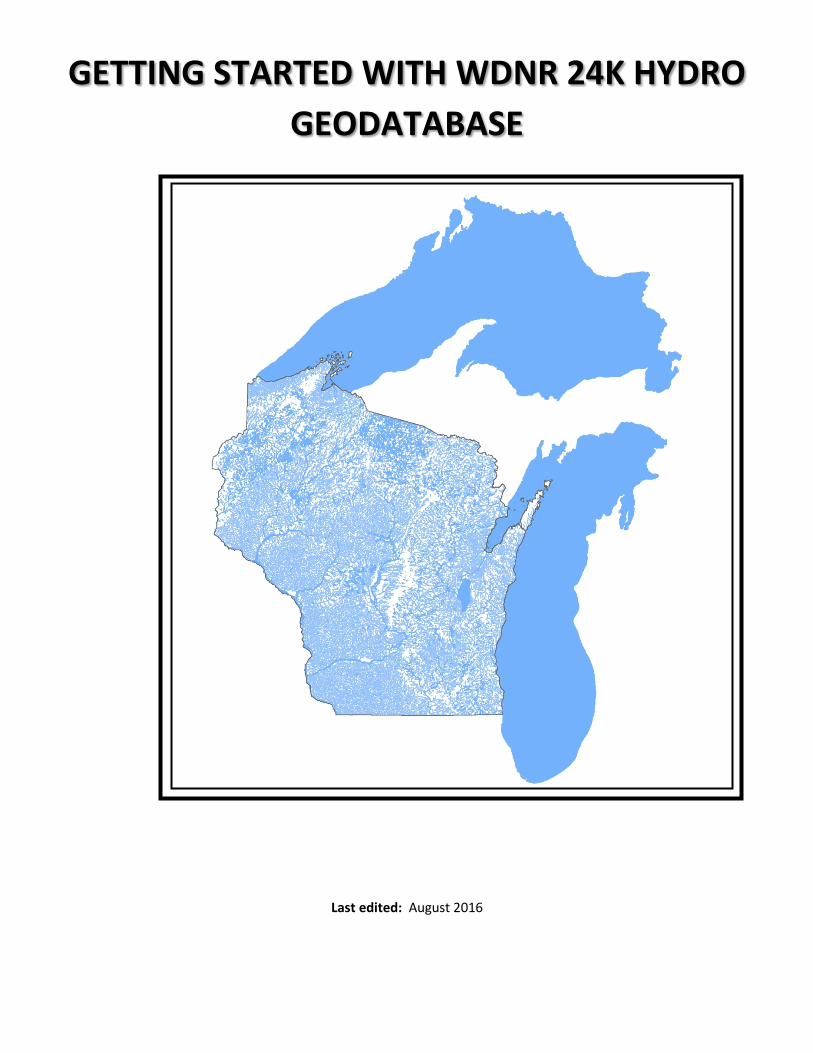
GETTING STARTED WITH WDNR 24K HYDRO GEODATABASE
Last edited: August 2016
TABLE OF CONTENTS
OVERVIEW ............................................................................................................................................. 1
WHAT IS A GEODATABASE? ................................................................................................................................................................... 1 HOW IS IT DIFFERENT THAN THE PREVIOUS COVERAGE / SHAPEFILES? ................................................................................................ 1 DATABASE SPECS ................................................................................................................................................................................... 2
Projection ......................................................................................................................................................................................... 2 Precision ........................................................................................................................................................................................... 2 Size.................................................................................................................................................................................................... 2
ACCESSING THE GEODATABASE ............................................................................................................ 2
LOCATION OF THE GEODATABASE ......................................................................................................................................................... 2 CONNECTING TO THE SDE HYDRO GEODATABASE USING ARCVIEW AND ARCMAP .............................................................................. 2 EXPORTING THE GEODATABASE ............................................................................................................................................................ 3
USING THE GEODATABASE .................................................................................................................... 4
LOADING THE DATA INTO ARCVIEW / ARCMAP ..................................................................................................................................... 4 CARTOGRAPHY ...................................................................................................................................................................................... 6
Layer Files ......................................................................................................................................................................................... 6 Symbolizing Intermittent vs Perennial and Primary vs Secondary flow ............................................................................................ 7
SPATIAL VIEWS .......................................................................................................................................................................................... 7 TRACING ................................................................................................................................................................................................ 9
APPENDIX A - GEODATABASE METADATA LINKS ................................................................................... 13
APPENDIX B - REQUESTING AN ARCSDE PERSONAL USER ACCOUNT ..................................................... 14
APPENDIX C - SAMPLE TRACING INSTRUCTIONS .................................................................................... 15
TRACE QUERY 1: FIND ALL TRIBUTARITES TO THE CLASS I TROUT STREAM PORTION OF BROWN CREEK IN BARRON COUNTY........... 15 TRACE QUERY 2: FIND THE SHORTEST PATH BETWEEN TWO POINTS (FROM BLACK RIVER – THE BULLET CHUTE UP TO HWY 35) ................. 19
APPENDIX D - GLOSSARY OF COMMON GEODATABASE TERMS................................................................ 22
APPENDIX E – EDITS.............................................................................................................................. 25
1
OVERVIEW
WHAT IS A GEODATABASE? WDNR 24K hydro was historically managed in ESRI ARC INFO coverage format and provided to the user community as shapefiles (hydlarc – lines and hydrshai – polygons). However, ESRI has developed a more robust spatial data storage and management system called “geodatabase” which has become the new standard framework for Arc GIS. Simply put, it is a container for spatial and attribute data which can take advantage of the latest data storage technologies. The geodatabase is a more robust and extendable data model compared to shapefiles and coverages. The main objective of the conversion of WDNR hydro from coverage to geodatabase was to take our existing hydro data and implement it in geodatabase. It was also important to keep the federal hydrography data model (National Hydrography Database – NHD) in mind during this transition. The NHD is now at 1:24,000 scale nation-wide and is already being managed in a geodatabase. USEPA, USGS, USFS as well as all of our neighboring state environmental agencies are adopting NHD as their framework surface water layer. It was determined that we should strive to be as consistent as possible with the federal model in order to facilitate a future consolidation of the WDNR hydro and federal NHD databases.
HOW IS IT DIFFERENT THAN THE PREVIOUS COVERAGE / SHAPEFILES?
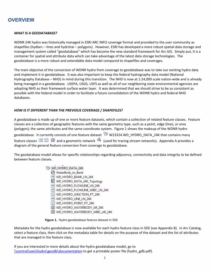
A geodatabase is made up of one or more feature datasets, which contain a collection of related feature classes. Feature classes are a collection of geographic features with the same geometry type, such as a point, edge (line), or area (polygon); the same attributes and the same coordinate system. Figure 1 shows the makeup of the WDNR hydro
geodatabase. It currently consists of one feature dataset W23324.WD_HYDRO_DATA_24K that contains many feature classes and a geometric network (used for tracing stream networks). Appendix A provides a diagram of the general feature conversion from coverage to geodatabase. The geodatabase model allows for specific relationships regarding adjacency, connectivity and data integrity to be defined between feature classes.
Figure 1. Hydro geodatabase feature dataset in SDE
Metadata for the hydro geodatabase is now available for each hydro feature class in SDE (see Appendix B). In Arc Catalog, select a feature class, then click on the metadata table for details on the purpose of the dataset and the list of attributes that are managed in the feature class. If you are interested in more details about the hydro geodatabase model, go to \\central\swis\hydro\geodb\documentation to get a printable poster file (hydro_gdb.pdf).
2
DATABASE SPECS
Projection
Wisconsin Transverse Mercator (WTM), North American Datum 1983/1991 adjustment (NAD91). This will be specified in ArcGIS version 10.0 as NAD 1983 Wisconsin TM (Meters).prj. You may be familiar with the previous naming convention of “NAD_1983_HARN_Transverse_Mercator” – same file, different name. Linear measures are in meters. Area measurements are in square meters.
Precision The 24K hydro layer is stored in SDE using high precision coordinate accuracy.
Size The hydro geodatabase is approximately 365MB in size.
ACCESSING THE GEODATABASE
LOCATION OF THE GEODATABASE For DNR employees, the geodatabase is stored centrally in the SDE data repository in the W23324 schema (directory). This is convenient for staff in the central office but may be somewhat problematic for the field offices due to network traffic issues. To use the geodatabase, it is recommended that field staff extract a local copy of the geodatabase on a regular basis. Instructions on how to properly export the database are provided under the Exporting the Geodatabase section at the bottom of page 3. The frequency of the extract will be up to each region based on their interest in keeping up with the edits. We also keep a copy out on our DNR FTP site for customers outside the department. It includes a file-based geodatabase, documentation and layer files. Location: ftp://dnrftp01.wi.gov/geodata/hydro_24k/
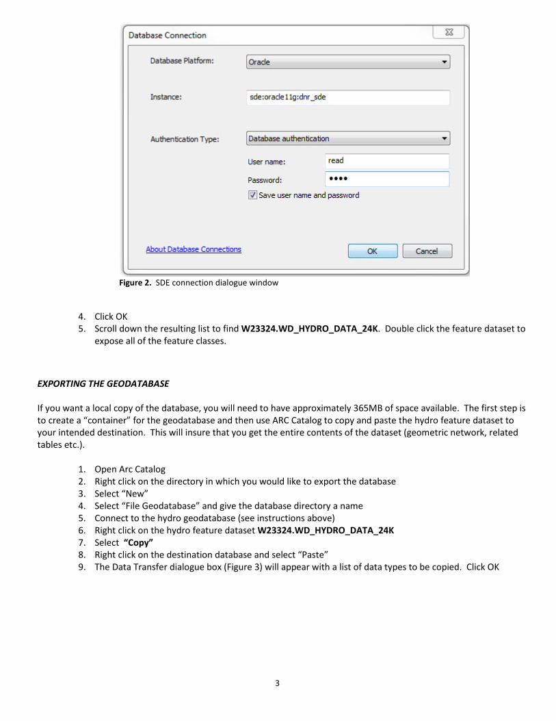
CONNECTING TO THE SDE HYDRO GEODATABASE USING ARCVIEW AND ARCMAP If you use ARCMAP 10.0 or 10.1 to view the hydro geodatabase, you will need to connect to production SDE using the Add Spatial Database Connection utility. The directions for connecting to SDE to view hydro are as follows:
1. From an existing ArcMap session, click the ADD DATA button OR from Arc Catalog, 2. Click on Database Connections 3. Double click Add Spatial Database Connections and fill in the dialogue box (Figure 2) using either your
personal Arc SDE login/password OR the generic User ID of READ and password ONLY temporarily if you don’t have your own Arc SDE personal login/password. This will connect you to production SDE.
3
Figure 2. SDE connection dialogue window
4. Click OK 5. Scroll down the resulting list to find W23324.WD_HYDRO_DATA_24K. Double click the feature dataset to
expose all of the feature classes.
EXPORTING THE GEODATABASE
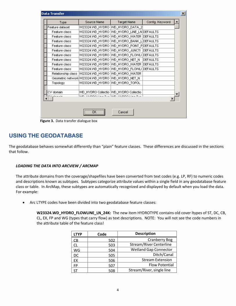
If you want a local copy of the database, you will need to have approximately 365MB of space available. The first step is to create a “container” for the geodatabase and then use ARC Catalog to copy and paste the hydro feature dataset to your intended destination. This will insure that you get the entire contents of the dataset (geometric network, related tables etc.).
1. Open Arc Catalog 2. Right click on the directory in which you would like to export the database 3. Select “New” 4. Select “File Geodatabase” and give the database directory a name 5. Connect to the hydro geodatabase (see instructions above) 6. Right click on the hydro feature dataset W23324.WD_HYDRO_DATA_24K 7. Select “Copy” 8. Right click on the destination database and select “Paste” 9. The Data Transfer dialogue box (Figure 3) will appear with a list of data types to be copied. Click OK
4
Figure 3. Data transfer dialogue box
USING THE GEODATABASE The geodatabase behaves somewhat differently than “plain” feature classes. These differences are discussed in the sections that follow.
LOADING THE DATA INTO ARCVIEW / ARCMAP
The attribute domains from the coverage/shapefiles have been converted from text codes (e.g. LP, RF) to numeric codes and descriptions known as subtypes. Subtypes categorize attribute values within a single field in any geodatabase feature class or table. In ArcMap, these subtypes are automatically recognized and displayed by default when you load the data. For example:
• Arc LTYPE codes have been divided into two geodatabase feature classes:
W23324.WD_HYDRO_FLOWLINE_LN_24K: The new item HYDROTYPE contains old cover ltypes of ST, DC, CB, CL, EX, FP and WG (types that carry flow) as text descriptions. NOTE: You will not see the code numbers in the attribute table of the feature class!
LTYP Code Description
CB 502 Cranberry Bog CL 503 Stream/River Centerline WG 504 Wetland Gap Connector DC 505 Ditch/Canal EX 506 Stream Extension FP 507 Flow Potential ST 508 Stream/River, single line
5
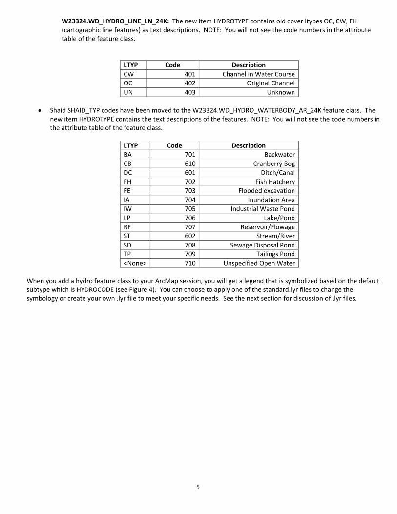
W23324.WD_HYDRO_LINE_LN_24K: The new item HYDROTYPE contains old cover ltypes OC, CW, FH (cartographic line features) as text descriptions. NOTE: You will not see the code numbers in the attribute table of the feature class.
LTYP Code Description CW 401 Channel in Water Course OC 402 Original Channel UN 403 Unknown
• Shaid SHAID_TYP codes have been moved to the W23324.WD_HYDRO_WATERBODY_AR_24K feature class. The
new item HYDROTYPE contains the text descriptions of the features. NOTE: You will not see the code numbers in the attribute table of the feature class.
LTYP Code Description BA 701 Backwater CB 610 Cranberry Bog DC 601 Ditch/Canal FH 702 Fish Hatchery FE 703 Flooded excavation IA 704 Inundation Area IW 705 Industrial Waste Pond LP 706 Lake/Pond RF 707 Reservoir/Flowage ST 602 Stream/River SD 708 Sewage Disposal Pond TP 709 Tailings Pond <None> 710 Unspecified Open Water
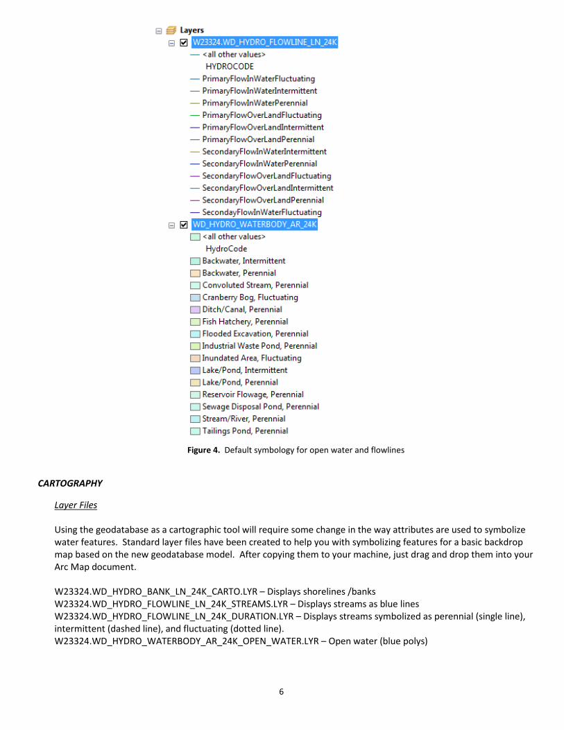
When you add a hydro feature class to your ArcMap session, you will get a legend that is symbolized based on the default subtype which is HYDROCODE (see Figure 4). You can choose to apply one of the standard.lyr files to change the symbology or create your own .lyr file to meet your specific needs. See the next section for discussion of .lyr files.
6
Figure 4. Default symbology for open water and flowlines
CARTOGRAPHY
Layer Files Using the geodatabase as a cartographic tool will require some change in the way attributes are used to symbolize water features. Standard layer files have been created to help you with symbolizing features for a basic backdrop map based on the new geodatabase model. After copying them to your machine, just drag and drop them into your Arc Map document. W23324.WD_HYDRO_BANK_LN_24K_CARTO.LYR – Displays shorelines /banks W23324.WD_HYDRO_FLOWLINE_LN_24K_STREAMS.LYR – Displays streams as blue lines W23324.WD_HYDRO_FLOWLINE_LN_24K_DURATION.LYR – Displays streams symbolized as perennial (single line), intermittent (dashed line), and fluctuating (dotted line). W23324.WD_HYDRO_WATERBODY_AR_24K_OPEN_WATER.LYR – Open water (blue polys)
7
Symbolizing Intermittent vs Perennial and Primary vs Secondary flow
In the coverage/shapefile model, flow (primary vs secondary) and duration (perennial, intermittent) were managed in separate fields. In the geodatabase, these two fields have been combined into the HYDROCODE item for QA/QC purposes. Hydrocode subtypes in the flowline feature class are as follows:
100 - Primary Flow Over Land Perennial 101 - Secondary Flow Over Land Perennial 110 - Primary Flow Over Land Intermittent 111 - Secondary Flow Over Land Intermittent 120 - Primary Flow Over Land Fluctuating 121 - Secondary Flow Over Land Fluctuating 200 - Primary Flow In Water Perennial 201 - Secondary Flow In Water Perennial 210 - Primary Flow In Water Intermittent 211 - Secondary Flow In Water Intermittent 220 - Primary Flow In Water Fluctuating 221 - Secondary Flow In Water Fluctuating
To symbolize streams as perennial or intermittent, you can either a) import the duration layer file or b) set the symbology of the flowline feature class as follows: 1. Right click on the flowline feature class in the legend 2. Select “Properties” 3. Click the Symbology tab 4. Click “Categories” in the Show: window on the left 5. Click “Unique Values” Under “Categories” 6. Click HYDROCODE in the Value Field box 7. Group all of the “perennial” records together by holding the <ctrl> key down while you click all the entries with
the word perennial in it. (NOTE: Primary vs secondary flow will not be differentiated in this exercise.) 8. Click the right mouse button on one of the selected records and select “Group Values” to consolidate all the
perennial records into one. 9. Group all of the “intermittent” records together by holding the <ctrl> key down while you click all the entries with
the word “intermittent” in it. 10. Click the right mouse button on one of the selected records and select “Group Values” to consolidate all the
intermittent records into one. 11. Group all of the “fluctuating” records together by holding the <ctrl> key down while you click all the entries with
the word “fluctuating” in it. 12. Click the right mouse button on one of the selected records and select “Group Values” to consolidate all the
fluctuating records into one. 13. Click on the symbol for each group to change the symbol and its color. Use this same grouping method if you want to group all primary flow records together and all secondary flow records together to symbolize them differently.
Spatial Views There are several spatial views in the hydro SDE schema (W23324) that you have access to. These can be loaded into your mxd as a feature class that has additional attribution. Note: The spatial views are located “outside” of the hydro dataset.
8
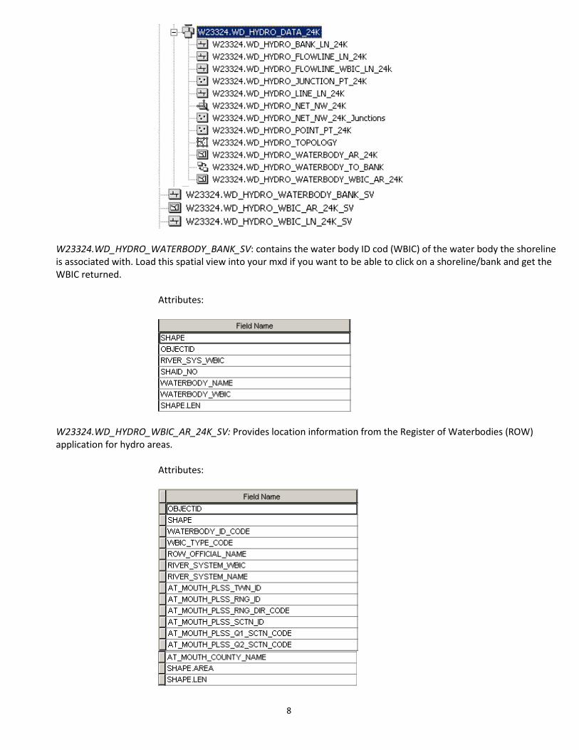
W23324.WD_HYDRO_WATERBODY_BANK_SV: contains the water body ID cod (WBIC) of the water body the shoreline is associated with. Load this spatial view into your mxd if you want to be able to click on a shoreline/bank and get the WBIC returned.
Attributes:
W23324.WD_HYDRO_WBIC_AR_24K_SV: Provides location information from the Register of Waterbodies (ROW) application for hydro areas.
Attributes:
9
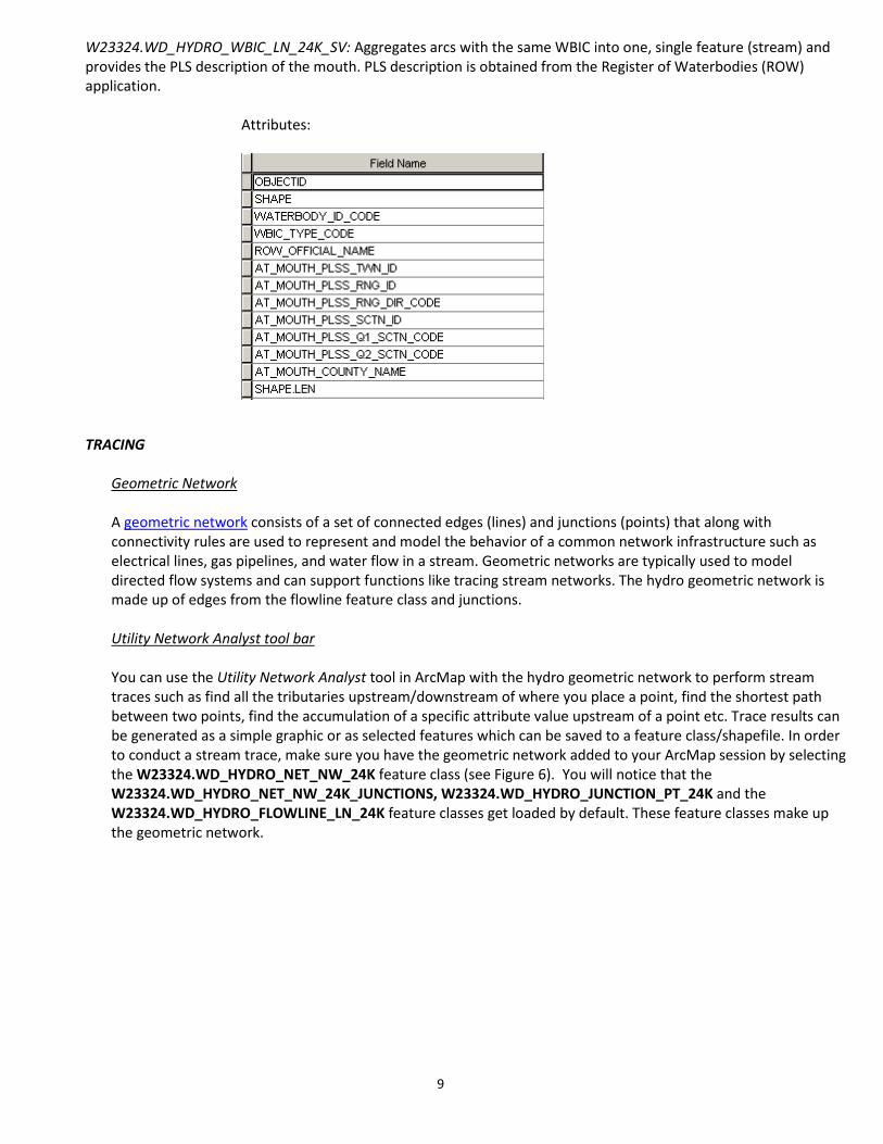
W23324.WD_HYDRO_WBIC_LN_24K_SV: Aggregates arcs with the same WBIC into one, single feature (stream) and provides the PLS description of the mouth. PLS description is obtained from the Register of Waterbodies (ROW) application.
Attributes:
TRACING
Geometric Network A geometric network consists of a set of connected edges (lines) and junctions (points) that along with connectivity rules are used to represent and model the behavior of a common network infrastructure such as electrical lines, gas pipelines, and water flow in a stream. Geometric networks are typically used to model directed flow systems and can support functions like tracing stream networks. The hydro geometric network is made up of edges from the flowline feature class and junctions.
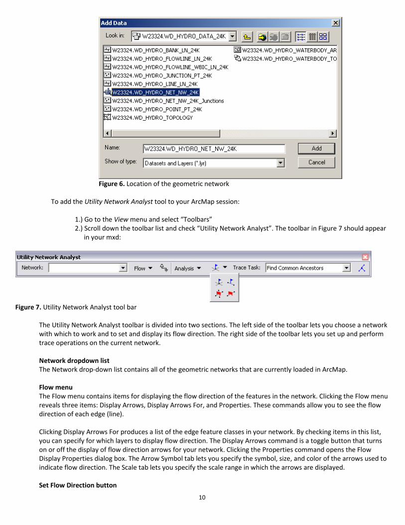
Utility Network Analyst tool bar You can use the Utility Network Analyst tool in ArcMap with the hydro geometric network to perform stream traces such as find all the tributaries upstream/downstream of where you place a point, find the shortest path between two points, find the accumulation of a specific attribute value upstream of a point etc. Trace results can be generated as a simple graphic or as selected features which can be saved to a feature class/shapefile. In order to conduct a stream trace, make sure you have the geometric network added to your ArcMap session by selecting the W23324.WD_HYDRO_NET_NW_24K feature class (see Figure 6). You will notice that the W23324.WD_HYDRO_NET_NW_24K_JUNCTIONS, W23324.WD_HYDRO_JUNCTION_PT_24K and the W23324.WD_HYDRO_FLOWLINE_LN_24K feature classes get loaded by default. These feature classes make up the geometric network.
10
Figure 6. Location of the geometric network
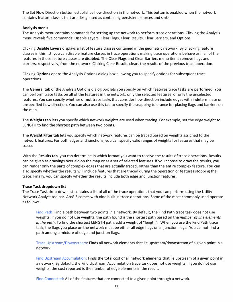
To add the Utility Network Analyst tool to your ArcMap session:
1.) Go to the View menu and select “Toolbars” 2.) Scroll down the toolbar list and check “Utility Network Analyst”. The toolbar in Figure 7 should appear
in your mxd:
Figure 7. Utility Network Analyst tool bar
The Utility Network Analyst toolbar is divided into two sections. The left side of the toolbar lets you choose a network with which to work and to set and display its flow direction. The right side of the toolbar lets you set up and perform trace operations on the current network. Network dropdown list The Network drop-down list contains all of the geometric networks that are currently loaded in ArcMap. Flow menu The Flow menu contains items for displaying the flow direction of the features in the network. Clicking the Flow menu reveals three items: Display Arrows, Display Arrows For, and Properties. These commands allow you to see the flow direction of each edge (line). Clicking Display Arrows For produces a list of the edge feature classes in your network. By checking items in this list, you can specify for which layers to display flow direction. The Display Arrows command is a toggle button that turns on or off the display of flow direction arrows for your network. Clicking the Properties command opens the Flow Display Properties dialog box. The Arrow Symbol tab lets you specify the symbol, size, and color of the arrows used to indicate flow direction. The Scale tab lets you specify the scale range in which the arrows are displayed. Set Flow Direction button
11
The Set Flow Direction button establishes flow direction in the network. This button is enabled when the network contains feature classes that are designated as containing persistent sources and sinks. Analysis menu The Analysis menu contains commands for setting up the network to perform trace operations. Clicking the Analysis menu reveals five commands: Disable Layers, Clear Flags, Clear Results, Clear Barriers, and Options. Clicking Disable Layers displays a list of feature classes contained in the geometric network. By checking feature classes in this list, you can disable feature classes in trace operations making trace operations behave as if all of the features in those feature classes are disabled. The Clear Flags and Clear Barriers menu items remove flags and barriers, respectively, from the network. Clicking Clear Results clears the results of the previous trace operation. Clicking Options opens the Analysis Options dialog box allowing you to specify options for subsequent trace operations. The General tab of the Analysis Options dialog box lets you specify on which features trace tasks are performed. You can perform trace tasks on all of the features in the network, only the selected features, or only the unselected features. You can specify whether or not trace tasks that consider flow direction include edges with indeterminate or unspecified flow direction. You can also use this tab to specify the snapping tolerance for placing flags and barriers on the map. The Weights tab lets you specify which network weights are used when tracing. For example, set the edge weight to LENGTH to find the shortest path between two points. The Weight Filter tab lets you specify which network features can be traced based on weights assigned to the network features. For both edges and junctions, you can specify valid ranges of weights for features that may be traced. With the Results tab, you can determine in which format you want to receive the results of trace operations. Results can be given as drawings overlaid on the map or as a set of selected features. If you choose to draw the results, you can render only the parts of complex edges that are actually traced, rather than the entire complex feature. You can also specify whether the results will include features that are traced during the operation or features stopping the trace. Finally, you can specify whether the results include both edge and junction features. Trace Task dropdown list The Trace Task drop-down list contains a list of all of the trace operations that you can perform using the Utility Network Analyst toolbar. ArcGIS comes with nine built-in trace operations. Some of the most commonly used operate as follows:
Find Path: Find a path between two points in a network. By default, the Find Path trace task does not use weights. If you do not use weights, the path found is the shortest path based on the number of line elements in the path. To find the shortest LENGTH path, add a weight of “length”. When you use the Find Path trace task, the flags you place on the network must be either all edge flags or all junction flags. You cannot find a path among a mixture of edge and junction flags.
Trace Upstream/Downstream: Finds all network elements that lie upstream/downstream of a given point in a network.
Find Upstream Accumulation: Finds the total cost of all network elements that lie upstream of a given point in a network. By default, the Find Upstream Accumulation trace task does not use weights. If you do not use weights, the cost reported is the number of edge elements in the result. Find Connected: All of the features that are connected to a given point through a network.
12
Find Disconnected: All of the features that are not connected to a given point through a network. Find Loops: Find loops that can result in multiple paths between points in a network.
Solve button While the Trace Task drop-down list is used to select the trace task, the Solve button is used to perform the trace operation once you have finished configuring your trace operation using the toolbar. The Solve button performs the trace operation that you selected in the Trace Task drop-down list by using the parameters that you specified using the Analysis Options dialog box and the placement of flags and barriers on the network. Appendix E provides sample instructions for performing two types of trace queries:
a.) find all tributaries upstream of the point you click b.) find shortest path between two points
13
APPENDIX A - GEODATABASE METADATA LINKS
W23324.WD_HYDRO_BANK_LN_24K W23324.WD_HYDRO_FLOWLINE_LN_24K W23324.WD_HYDRO_FLOWLINE_WBIC_LN_24K W23324.WD_HYDRO_JUNCTION_PT_24K W23324.WD_HYDRO_LINE_24K W23324.WD_HYDRO_POINT_PT_24K W23324.WD_HYDRO_WATERBODY_AR_24K W23324.WD_HYDRO_WATERBODY_WBIC_AR_24K
14
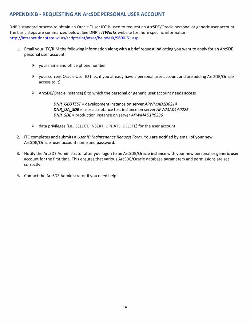
APPENDIX B - REQUESTING AN ArcSDE PERSONAL USER ACCOUNT
DNR’s standard process to obtain an Oracle “User ID” is used to request an ArcSDE/Oracle personal or generic user account. The basic steps are summarized below. See DNR’s ITWorks website for more specific information: http://intranet.dnr.state.wi.us/scripts/int/at/et/helpdesk/9600-61.asp.
1. Email your ITC/RIM the following information along with a brief request indicating you want to apply for an ArcSDE personal user account: your name and office phone number
your current Oracle User ID (i.e., if you already have a personal user account and are adding ArcSDE/Oracle
access to it)
ArcSDE/Oracle instance(s) to which the personal or generic user account needs access
DNR_GEOTEST = development instance on server APWMAD1D0214 DNR_UA_SDE = user acceptance test instance on server APWMAD1A0226 DNR_SDE = production instance on server APWMAD1P0236
data privileges (i.e., SELECT, INSERT, UPDATE, DELETE) for the user account.
2. ITC completes and submits a User ID Maintenance Request Form. You are notified by email of your new ArcSDE/Oracle user account name and password.
3. Notify the ArcSDE Administrator after you logon to an ArcSDE/Oracle instance with your new personal or generic user account for the first time. This ensures that various ArcSDE/Oracle database parameters and permissions are set correctly.
4. Contact the ArcSDE Administrator if you need help.
15
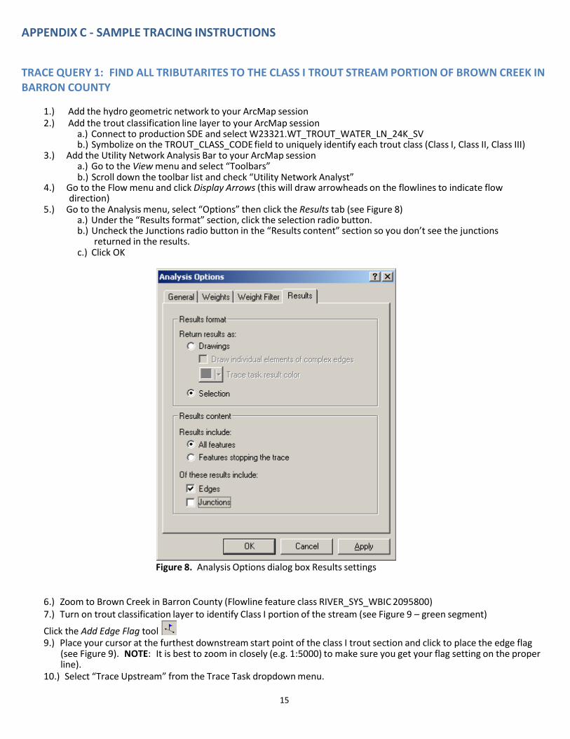
APPENDIX C - SAMPLE TRACING INSTRUCTIONS
TRACE QUERY 1: FIND ALL TRIBUTARITES TO THE CLASS I TROUT STREAM PORTION OF BROWN CREEK IN BARRON COUNTY
1.) Add the hydro geometric network to your ArcMap session 2.) Add the trout classification line layer to your ArcMap session
a.) Connect to production SDE and select W23321.WT_TROUT_WATER_LN_24K_SV b.) Symbolize on the TROUT_CLASS_CODE field to uniquely identify each trout class (Class I, Class II, Class III)
3.) Add the Utility Network Analysis Bar to your ArcMap session a.) Go to the View menu and select “Toolbars” b.) Scroll down the toolbar list and check “Utility Network Analyst”
4.) Go to the Flow menu and click Display Arrows (this will draw arrowheads on the flowlines to indicate flow direction)
5.) Go to the Analysis menu, select “Options” then click the Results tab (see Figure 8) a.) Under the “Results format” section, click the selection radio button. b.) Uncheck the Junctions radio button in the “Results content” section so you don’t see the junctions
returned in the results. c.) Click OK
Figure 8. Analysis Options dialog box Results settings
6.) Zoom to Brown Creek in Barron County (Flowline feature class RIVER_SYS_WBIC 2095800) 7.) Turn on trout classification layer to identify Class I portion of the stream (see Figure 9 – green segment)
Click the Add Edge Flag tool 9.) Place your cursor at the furthest downstream start point of the class I trout section and click to place the edge flag
(see Figure 9). NOTE: It is best to zoom in closely (e.g. 1:5000) to make sure you get your flag setting on the proper line).
10.) Select “Trace Upstream” from the Trace Task dropdown menu.

16
11.) Click the Solve button to initiate the trace.
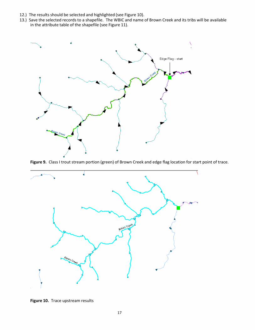
17
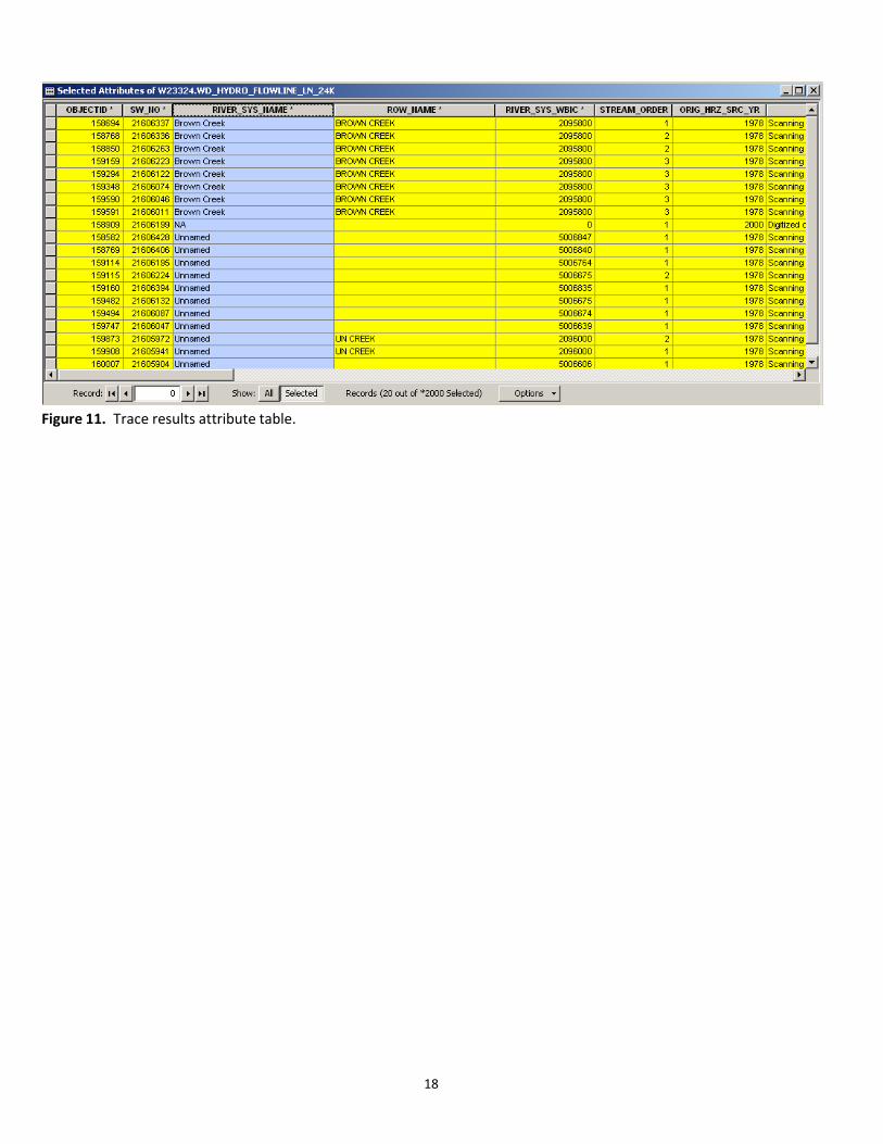
12.) The results should be selected and highlighted (see Figure 10). 13.) Save the selected records to a shapefile. The WBIC and name of Brown Creek and its tribs will be available
in the attribute table of the shapefile (see Figure 11).
Figure 9. Class I trout stream portion (green) of Brown Creek and edge flag location for start point of trace.
Figure 10. Trace upstream results
18
Figure 11. Trace results attribute table.
19
TRACE QUERY 2: FIND THE SHORTEST PATH BETWEEN TWO POINTS (From Black River – The Bullet Chute up to Hwy 35)
1.) Add the hydro geometric network to your ArcMap session 2.) Add the roads to your ArcMap session (K:\dvgislib\wi_tile\basehd_2\rdwlw924\rdwlarc.shp) 3.) Add the Utility Network Analysis Bar to your ArcMap session
a. Go to the View menu and select “Toolbars” b. Scroll down the toolbar list and check “Utility Network Analyst”
4.) Go to the Flow menu and click Display Arrows (this will draw arrowheads to indicate flow direction) 5.) Trace results are by default returned as a drawing/graphic. If you want the results to be returned as a
selection of arcs, go to the Analysis menu, select “Options” then click the Results tab. a. Under the “Results format” section, click the selection radio button. b. Uncheck the Junctions radio button in the “Results content” section so you don’t see the junctions
returned in the results. c. Click OK
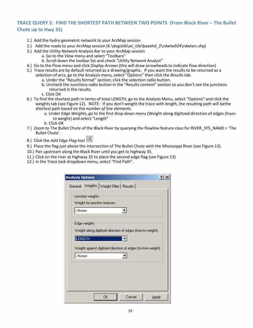
6.) To find the shortest path in terms of total LENGTH, go to the Analysis Menu, select “Options” and click the weights tab (see Figure 12). NOTE: If you don’t weight the trace with length, the resulting path will bethe shortest path based on the number of line elements.
a. Under Edge Weights, go to the first drop down menu (Weight along digitized direction of edges (from-to weight) and select “Length”
b. Click OK 7.) Zoom to The Bullet Chute of the Black River by querying the flowline feature class for RIVER_SYS_NAME = ‘The
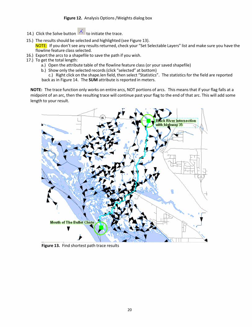
Bullet Chute’.
8.) Click the Add Edge Flag tool 9.) Place the flag just above the intersection of The Bullet Chute with the Mississippi River (see Figure 13). 10.) Pan upstream along the Black River until you get to highway 35. 11.) Click on the river at highway 35 to place the second edge flag (see Figure 13) 12.) In the Trace task dropdown menu, select “Find Path”.
20
Figure 12. Analysis Options /Weights dialog box
14.) Click the Solve button to initiate the trace. 15.) The results should be selected and highlighted (see Figure 13).
NOTE: If you don’t see any results returned, check your “Set Selectable Layers” list and make sure you have the flowline feature class selected.
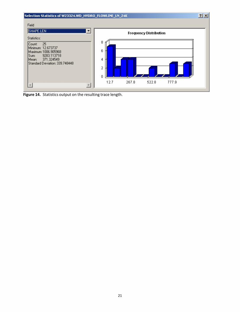
16.) Export the arcs to a shapefile to save the path if you wish. 17.) To get the total length:
a.) Open the attribute table of the flowline feature class (or your saved shapefile) b.) Show only the selected records (click “selected” at bottom)
c.) Right click on the shape.len field, then select “Statistics”. The statistics for the field are reported back as in Figure 14. The SUM attribute is reported in meters.
NOTE: The trace function only works on entire arcs, NOT portions of arcs. This means that if your flag falls at a midpoint of an arc, then the resulting trace will continue past your flag to the end of that arc. This will add some length to your result.
Figure 13. Find shortest path trace results
21
Figure 14. Statistics output on the resulting trace length.
22
APPENDIX D - GLOSSARY OF COMMON GEODATABASE TERMS (from ESRI on-line glossary)
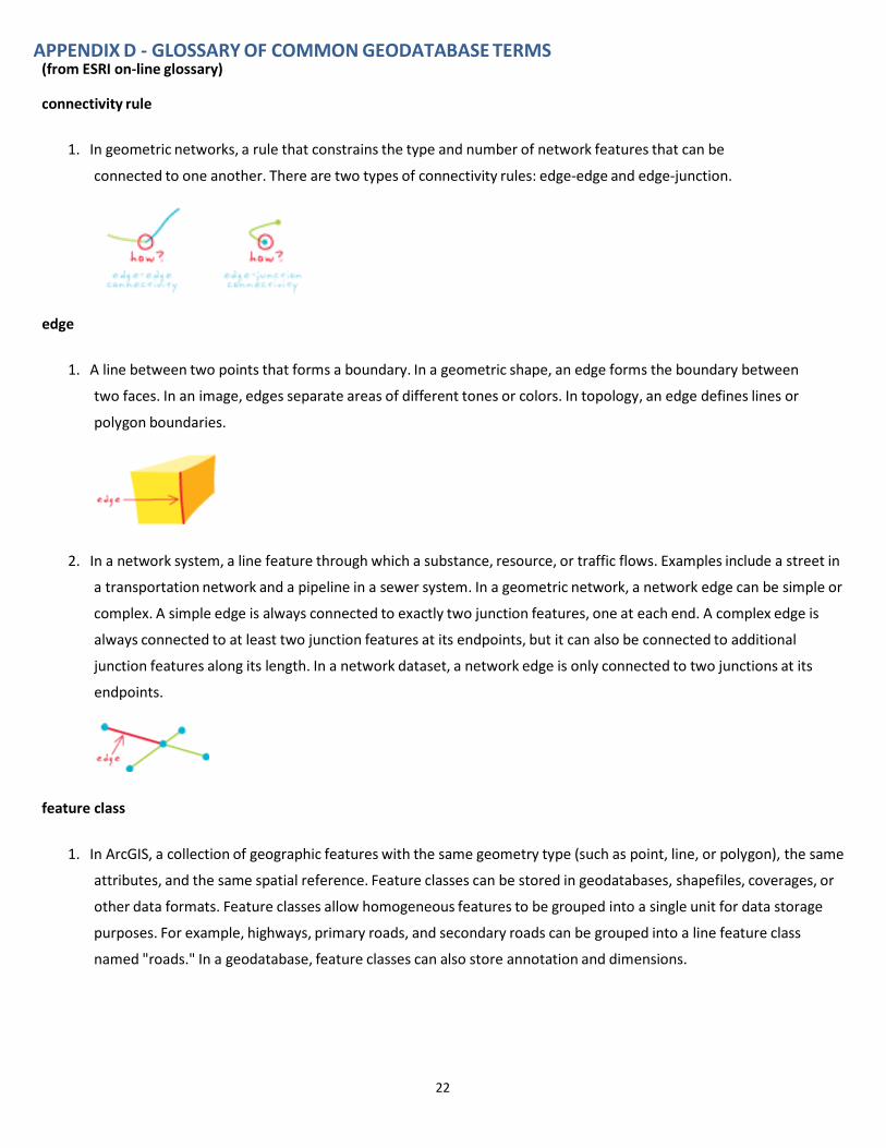
connectivity rule
1. In geometric networks, a rule that constrains the type and number of network features that can be
connected to one another. There are two types of connectivity rules: edge-edge and edge-junction.
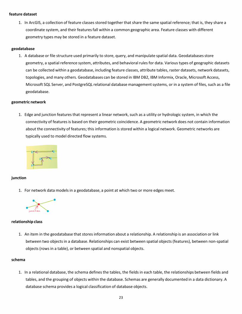
edge
1. A line between two points that forms a boundary. In a geometric shape, an edge forms the boundary between
two faces. In an image, edges separate areas of different tones or colors. In topology, an edge defines lines or
polygon boundaries.
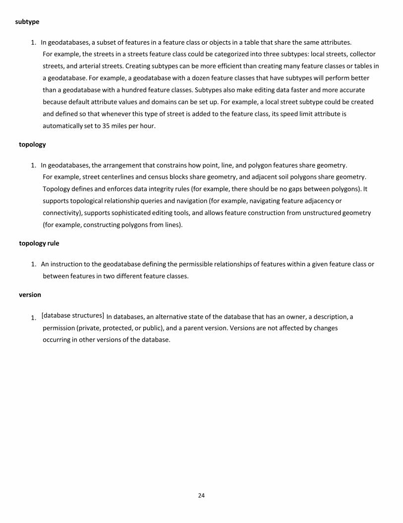
2. In a network system, a line feature through which a substance, resource, or traffic flows. Examples include a street in
a transportation network and a pipeline in a sewer system. In a geometric network, a network edge can be simple or
complex. A simple edge is always connected to exactly two junction features, one at each end. A complex edge is
always connected to at least two junction features at its endpoints, but it can also be connected to additional
junction features along its length. In a network dataset, a network edge is only connected to two junctions at its
endpoints.
feature class
1. In ArcGIS, a collection of geographic features with the same geometry type (such as point, line, or polygon), the same
attributes, and the same spatial reference. Feature classes can be stored in geodatabases, shapefiles, coverages, or
other data formats. Feature classes allow homogeneous features to be grouped into a single unit for data storage
purposes. For example, highways, primary roads, and secondary roads can be grouped into a line feature class
named "roads." In a geodatabase, feature classes can also store annotation and dimensions.
23
feature dataset
1. In ArcGIS, a collection of feature classes stored together that share the same spatial reference; that is, they share a
coordinate system, and their features fall within a common geographic area. Feature classes with different
geometry types may be stored in a feature dataset.
geodatabase
1. A database or file structure used primarily to store, query, and manipulate spatial data. Geodatabases store
geometry, a spatial reference system, attributes, and behavioral rules for data. Various types of geographic datasets
can be collected within a geodatabase, including feature classes, attribute tables, raster datasets, network datasets,
topologies, and many others. Geodatabases can be stored in IBM DB2, IBM Informix, Oracle, Microsoft Access,
Microsoft SQL Server, and PostgreSQL relational database management systems, or in a system of files, such as a file
geodatabase.
geometric network
1. Edge and junction features that represent a linear network, such as a utility or hydrologic system, in which the
connectivity of features is based on their geometric coincidence. A geometric network does not contain information
about the connectivity of features; this information is stored within a logical network. Geometric networks are
typically used to model directed flow systems.
junction
1. For network data models in a geodatabase, a point at which two or more edges meet.
relationship class
1. An item in the geodatabase that stores information about a relationship. A relationship is an association or link
between two objects in a database. Relationships can exist between spatial objects (features), between non-spatial
objects (rows in a table), or between spatial and nonspatial objects.
schema
1. In a relational database, the schema defines the tables, the fields in each table, the relationships between fields and
tables, and the grouping of objects within the database. Schemas are generally documented in a data dictionary. A
database schema provides a logical classification of database objects.
24
subtype
1. In geodatabases, a subset of features in a feature class or objects in a table that share the same attributes.
For example, the streets in a streets feature class could be categorized into three subtypes: local streets, collector
streets, and arterial streets. Creating subtypes can be more efficient than creating many feature classes or tables in
a geodatabase. For example, a geodatabase with a dozen feature classes that have subtypes will perform better
than a geodatabase with a hundred feature classes. Subtypes also make editing data faster and more accurate
because default attribute values and domains can be set up. For example, a local street subtype could be created
and defined so that whenever this type of street is added to the feature class, its speed limit attribute is
automatically set to 35 miles per hour.
topology
1. In geodatabases, the arrangement that constrains how point, line, and polygon features share geometry.
For example, street centerlines and census blocks share geometry, and adjacent soil polygons share geometry.
Topology defines and enforces data integrity rules (for example, there should be no gaps between polygons). It
supports topological relationship queries and navigation (for example, navigating feature adjacency or
connectivity), supports sophisticated editing tools, and allows feature construction from unstructured geometry
(for example, constructing polygons from lines).
topology rule
1. An instruction to the geodatabase defining the permissible relationships of features within a given feature class or
between features in two different feature classes.
version
1. [database structures] In databases, an alternative state of the database that has an owner, a description, a permission (private, protected, or public), and a parent version. Versions are not affected by changes
occurring in other versions of the database.
25
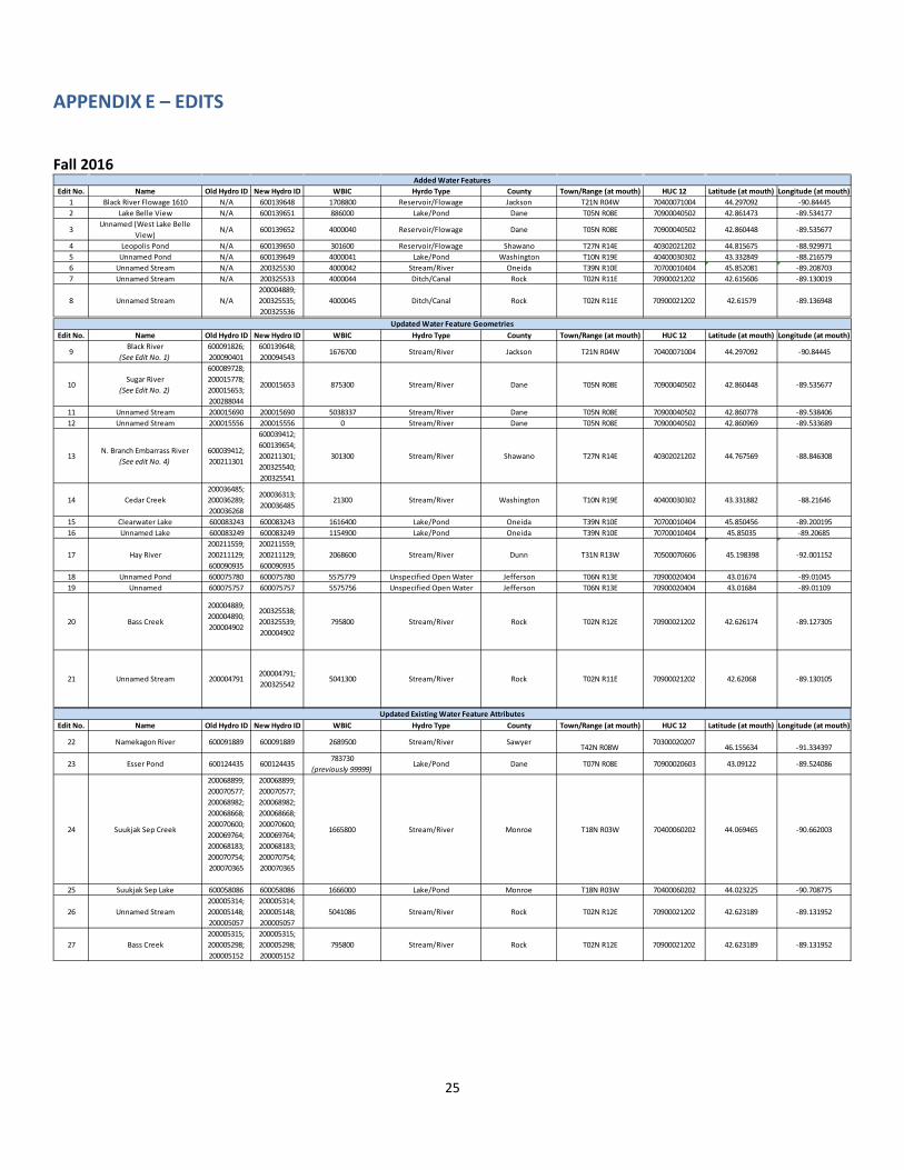
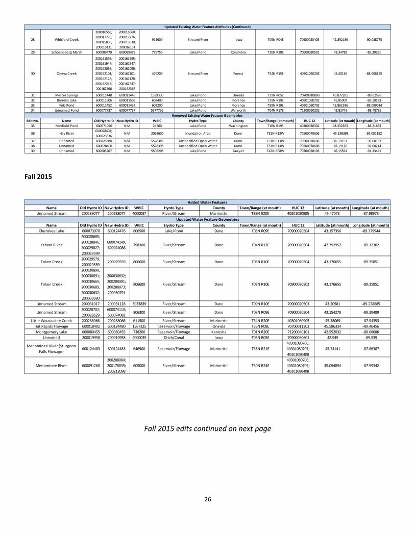
APPENDIX E – EDITS Fall 2016
Edit No. Name Old Hydro ID New Hydro ID WBIC Hyrdo Type County Town/Range (at mouth) HUC 12 Latitude (at mouth) Longitude (at mouth)1 Black River Flowage 1610 N/A 600139648 1708800 Reservoir/Flowage Jackson T21N R04W 70400071004 44.297092 -90.844452 Lake Belle View N/A 600139651 886000 Lake/Pond Dane T05N R08E 70900040502 42.861473 -89.534177
3Unnamed (West Lake Belle
View)N/A 600139652 4000040 Reservoir/Flowage Dane T05N R08E 70900040502 42.860448 -89.535677
4 Leopolis Pond N/A 600139650 301600 Reservoir/Flowage Shawano T27N R14E 40302021202 44.815675 -88.9299715 Unnamed Pond N/A 600139649 4000041 Lake/Pond Washington T10N R19E 40400030302 43.332849 -88.2165796 Unnamed Stream N/A 200325530 4000042 Stream/River Oneida T39N R10E 70700010404 45.852081 -89.2087037 Unnamed Stream N/A 200325533 4000044 Ditch/Canal Rock T02N R11E 70900021202 42.615606 -89.130019
8 Unnamed Stream N/A200004889;200325535;200325536
4000045 Ditch/Canal Rock T02N R11E 70900021202 42.61579 -89.136948
Added Water Features
Edit No. Name Old Hydro ID New Hydro ID WBIC Hydro Type County Town/Range (at mouth) HUC 12 Latitude (at mouth) Longitude (at mouth)
9Black River
(See Edit No. 1)600091826;200090401
600139648;200094543
1676700 Stream/River Jackson T21N R04W 70400071004 44.297092 -90.84445
10Sugar River
(See Edit No. 2)
600089728; 200015778; 200015653; 200288044
200015653 875300 Stream/River Dane T05N R08E 70900040502 42.860448 -89.535677
11 Unnamed Stream 200015690 200015690 5038337 Stream/River Dane T05N R08E 70900040502 42.860778 -89.53840612 Unnamed Stream 200015556 200015556 0 Stream/River Dane T05N R08E 70900040502 42.860969 -89.533689
13N. Branch Embarrass River
(See edit No. 4)600039412; 200211301
600039412;600139654;200211301;200325540;200325541
301300 Stream/River Shawano T27N R14E 40302021202 44.767569 -88.846308
14 Cedar Creek200036485; 200036289; 200036268
200036313;200036485
21300 Stream/River Washington T10N R19E 40400030302 43.331882 -88.21646
15 Clearwater Lake 600083243 600083243 1616400 Lake/Pond Oneida T39N R10E 70700010404 45.850456 -89.20019516 Unnamed Lake 600083249 600083249 1154900 Lake/Pond Oneida T39N R10E 70700010404 45.85035 -89.20685
17 Hay River200211559; 200211129; 600090935
200211559; 200211129; 600090935
2068600 Stream/River Dunn T31N R13W 70500070606 45.198398 -92.001152
18 Unnamed Pond 600075780 600075780 5575779 Unspecified Open Water Jefferson T06N R13E 70900020404 43.01674 -89.0104519 Unnamed 600075757 600075757 5575756 Unspecified Open Water Jefferson T06N R13E 70900020404 43.01684 -89.01109
20 Bass Creek
200004889;200004890;200004902
200325538;200325539;200004902
795800 Stream/River Rock T02N R12E 70900021202 42.626174 -89.127305
21 Unnamed Stream 200004791200004791;200325542
5041300 Stream/River Rock T02N R11E 70900021202 42.62068 -89.130105
Updated Water Feature Geometries
Edit No. Name Old Hydro ID New Hydro ID WBIC Hydro Type County Town/Range (at mouth) HUC 12 Latitude (at mouth) Longitude (at mouth)
22 Namekagon River 600091889 600091889 2689500 Stream/River SawyerT42N R08W
7030002020746.155634 -91.334397
23 Esser Pond 600124435 600124435783730
(previously 99999)Lake/Pond Dane T07N R08E 70900020603 43.09122 -89.524086
24 Suukjak Sep Creek
200068899;200070577;200068982;200068668;200070600;200069764;200068183;200070754;200070365
200068899;200070577;200068982;200068668;200070600;200069764;200068183;200070754;200070365
1665800 Stream/River Monroe T18N R03W 70400060202 44.069465 -90.662003
25 Suukjak Sep Lake 600058086 600058086 1666000 Lake/Pond Monroe T18N R03W 70400060202 44.023225 -90.708775
26 Unnamed Stream200005314;200005148;200005057
200005314;200005148;200005057
5041086 Stream/River Rock T02N R12E 70900021202 42.623189 -89.131952
27 Bass Creek200005315;200005298;200005152
200005315;200005298;200005152
795800 Stream/River Rock T02N R12E 70900021202 42.623189 -89.131952
Updated Existing Water Feature Attributes
26
Fall 2015
Fall 2015 edits continued on next page
28 Whitford Creek
200016560;200017276;200015830;200016131
200016560;200017276;200015830;200016131
911900 Stream/River Iowa T05N R04E 70900030403 42.892189 -90.038775
29 Schoeneberg Marsh 600089479 600089479 779750 Lake/Pond Columbia T10N R10E 70900020501 43.34782 -89.30651
30 Oneva Creek
200161595;200161947;200162096;200162101;200162128;200162247;200162366
200161595;200161947;200162096;200162101;200162128;200162247;200162366
476200 Stream/River Forest T34N R15E 40301040203 45.40136 -88.606155
31 Mercer Springs 600011448 600011448 1539300 Lake/Pond Oneida T39N R05E 70700010806 45.877285 -89.8259832 Barrens Lake 600011506 600011506 602400 Lake/Pond Florence T39N R19E 40301080702 45.85907 -88.1012333 Folz Pond 600011452 600011452 602200 Lake/Pond Florence T39N R19E 40301080702 45.861916 -88.09901434 Unnamed Pond 600077737 600077737 5577736 Lake/Pond Walworth T04N R17E 71200060202 42.82749 -88.48795
Updated Existing Water Feature Attributes (Continued)
Edit No. Name Old Hydro ID New Hydro ID WBIC Hydro Type County Town/Range (at mouth) HUC 12 Latitude (at mouth) Longitude (at mouth)35 Mayfield Pond 600071026 N/A 24700 Lake/Pond Washington T10N R19E 40400030302 43.332363 -88.21833
36 Hay River600028404; 600028336
N/A 2068600 Inundation Area Dunn T31N R13W 70500070606 45.198398 -92.001152
37 Unnamed 600028388 N/A 5528386 Unspecified Open Water Dunn T31N R13W 70500070606 45.19151 -92.0015338 Unnamed 600028400 N/A 5528398 Unspecified Open Water Dunn T31N R13W 70500070606 45.19126 -92.0021439 Unnamed 600005207 N/A 5505205 Lake/Pond Sawyer T42N R08W 70300020105 46.15554 -91.33441
Removed Existing Water Feature Geometries
Name Old Hydro ID New Hydro ID WBIC Hyrdo Type County Town/Range (at mouth) HUC 12 Latitude (at mouth) Longitude (at mouth)Unnamed Stream 200288077 200288077 4000037 River/Stream Marinette T35N R20E 40301080905 45.47073 -87.98978
Added Water Features
Name Old Hydro ID New Hydro ID WBIC Hydro Type County Town/Range (at mouth) HUC 12 Latitude (at mouth) Longitude (at mouth)Cherokee Lake 600073970 600124476 806500 Lake/Pond Dane T08N R09E 70900020504 43.157356 -89.379944
Yahara River
200028685; 200028846; 200029827; 200029599
600074149; 600074086
798300 River/Stream Dane T04N R12E 70900020504 42.792957 -89.12302
Token Creek200029579; 200029559
200029559 806600 River/Stream Dane T08N R10E 70900020504 43.176655 -89.35851
Token Creek
200030890; 200030891; 200030665; 200030689; 200030632; 200030690
200030632; 200288081; 200288073; 200030791
806600 River/Stream Dane T08N R10E 70900020503 43.176655 -89.35851
Unnamed Stream 200031017 200031128 5033839 River/Stream Dane T09N R10E 70900020503 43.20581 -89.278885
Unnamed Stream200028702; 200028629
600074110; 600074082
806300 River/Stream Dane T08N R09E 70900020504 43.154278 -89.38489
Little Wausaukee Creek 200288066 200288066 611500 River/Stream Marinette T34N R20E 40301080905 45.38069 -87.94353Hat Rapids Flowage 600018492 600124480 1567325 Reservoir/Flowage Oneida T36N R08E 70700011302 45.586334 -89.46456Montgomery Lake 600080455 600080455 738200 Reservoir/Flowage Kenosha T01N R20E 71200040101 42.552032 -88.08686
Unnamed 200019958 200019958 4000039 Ditch/Canal Iowa T06N R05E 70900030601 42.949 -89.939
Menominee River (Sturgeon Falls Flowage)
600124483 600124483 646900 Reservoir/Flowage Marinette T38N R21E40301080706; 40301080707; 40301080408
45.74141 -87.86387
Menominee River 600091260200288084; 200178839; 200212098
609000 River/Stream Marinette T30N R24E40301080706; 40301080707; 40301080408
45.094894 -87.59342
Updated Water Feature Geometries
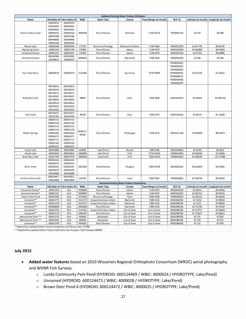
27
July 2015
• Added water features based on 2010 Wisconsin Regional Orthophoto Consortium (WROC) aerial photography
and WDNR Fish Surveys. o Lunda Community Park Pond (HYDROID: 600124469 / WBIC: 4000024 / HYDROTYPE: Lake/Pond) o Unnamed (HYDROID: 600124473 / WBIC: 4000028 / HYDROTYPE: Lake/Pond) o Brown Deer Pond 4 (HYDROID: 600124472 / WBIC: 4000025 / HYDROTYPE: Lake/Pond)
Name Old Hydro ID New Hydro ID WBIC Hydro Type County Town/Range (at mouth) HUC 12 Latitude (at mouth) Longitude (at mouth)
Cherry Valley Creek
200044979; 200045087; 200044934; 200045016; 200044788; 200044886; 200045350
200044979; 200045087; 200044934; 200045016; 200044788; 200044886; 200045350
4000038 River/Stream Richland T12N R01W 70700051102 43.524 -90.488
Mason Lake 600065099 600065099 175700 Reservoir/Flowage Marquette/Adams T14N R08E 40302010203 43.657795 -89.60795Big Spring Creek 200051933 200051799 176400 River/Stream Adams T14N R07E 40302010203 43.664883 -89.63803Unnamed Stream 200052197 200051937 176300 River/Stream Adams T14N R07E 40302010203 43.67223 -89.60886
Unnamed Stream200165085; 200288070
200165085; 200288070
4000036 River/Stream Marinette T34N R20E 40302010203 45.448 -87.998
Eau Claire River 600039579 600039579 2125600 River/Stream Eau Claire T27N R09W
70500050502; 70500060301; 70500060304; 70500060506; 70500060507; 70500060508; 70500060509
44.811703 -91.50321
Rieboldt Creek
200148053; 200148323; 200149217; 200149367; 200149665; 200149914; 200150422; 200150423
200148053; 200148323; 200149217; 200149367; 200149665; 200149914; 200150422; 200150423
99000 River/Stream Door T30N R28E 40301020103 45.09493 -87.081726
Peil Creek200145027; 200145303
200145027; 200145303
98700 River/Stream Door T30N R27E 40301020105 45.05535 -87.16484
Muehl Springs
200061515; 200061534; 200061572; 200061578; 200061663; 200061677; 200061717; 200061594; 200061622
200061515; 200061534; 200061572; 200061578; 200061663; 200061677; 200061717; 200061594; 200061622
5026271; 58700
River/Stream Sheboygan T16N R21E 40301011106 43.863983 -88.02073
Updated Existing Water Feature Attributes
Kuplic Lake 600034882 600034882 422600 Lake/Pond Oconto T28N R19E 40301040403 44.93102 -88.1812Bosak Lake 600016814 600016814 2666000 Lake/Pond Polk T37N R16W 70300010903 45.643246 -92.33826
Black Bear Lake 600017976 600017976 2669200 Lake/Pond Polk T36N R15W 70300010902 45.596146 -92.177086
Birch Creek
200204165; 200204275; 200204347; 200204470; 200204880
200204165; 200204275; 200204347; 200204470; 200204880
2833500 River/Stream Douglas T48N R13W 40103010502 46.622833 -92.03065
Smith Conley Creek200019957; 200019958
200019957; 200019958
914100 River/Stream Iowa T05N R05E 70900030601 42.939754 -89.92059
Name Old Hydro ID New Hydro ID WBIC Hydro Type County Town/Range (at mouth) HUC 12 Latitude (at mouth) Longitude (at mouth)Unnamed Stream* 200051933 N/A 5028689 River/Stream Adams T14N R07E 40302010203 43.66352 -89.62684Unnamed Stream* 200052197 N/A 5028600 River/Stream Adams T14N R07E 40302010203 43.665752 -89.60532Token Creek Pond 600073405 N/A 5573404 Reservoir/Flowage Dane T09N R10E 70900020503 43.202312 -89.28549
Unnamed** 600013775 N/A 5513773 Unspecified Open Water Marinette T38N R21E 40301080706 45.75332 -87.89024Unnamed** 600013759 N/A 5513757 Unspecified Open Water Marinette T38N R21E 40301080706 45.7523 -87.88006Unnamed** 600090830 N/A 5004248 River/Stream Marinette T38N R21E 40301080706 45.751793 -87.87542Unnamed** 600013763 N/A 5513761 Unspecified Open Water Out of State Out of State 40301080706 45.753757 -87.89464Unnamed** 600013719 N/A 5004165 River/Stream Out of State Out of State 40301080706 45.754627 -87.88612
Menominee River ** 600013725 N/A 609000 Backwater Out of State Out of State 40301080706 45.755 -87.883Menominee River ** 600013663 N/A 609000 Backwater Out of State Out of State 40301080706 45.756 -87.875
Unnamed** 600013790 N/A 5004263 River/Stream Out of State Out of State 40301080408 45.752 -87.858* Replaced by Updated Water Feature Attributes (see Mason Lake 175700)** Replaced by Updated Water Feature Geometry (see Sturgeon Falls Flowage 646900)
Removed Existing Water Feature Geometries
28
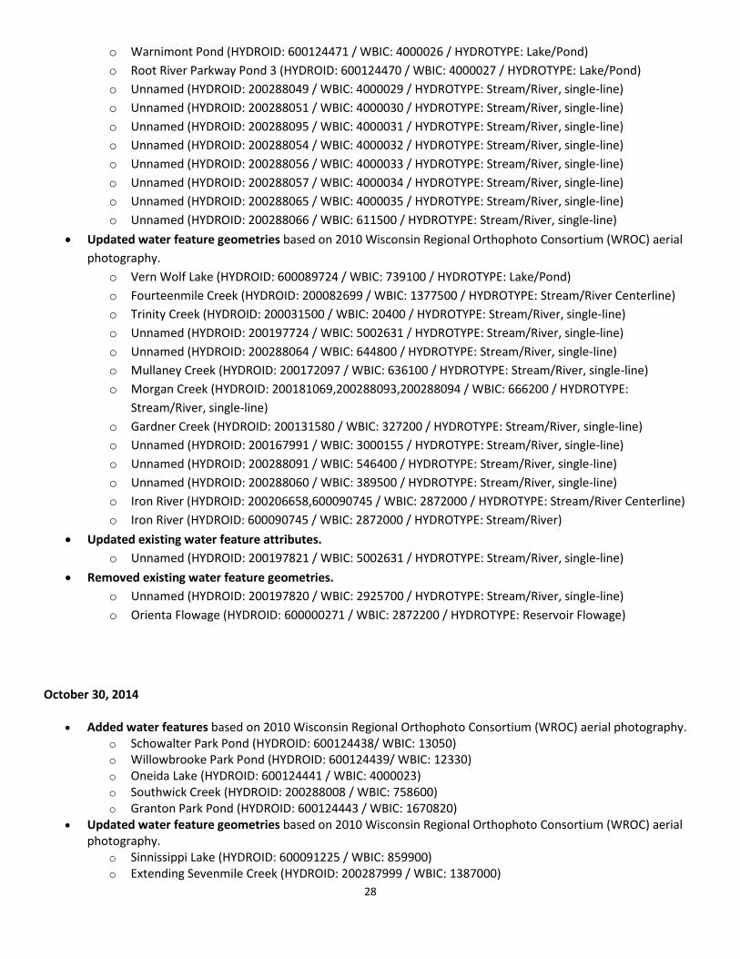
o Warnimont Pond (HYDROID: 600124471 / WBIC: 4000026 / HYDROTYPE: Lake/Pond) o Root River Parkway Pond 3 (HYDROID: 600124470 / WBIC: 4000027 / HYDROTYPE: Lake/Pond) o Unnamed (HYDROID: 200288049 / WBIC: 4000029 / HYDROTYPE: Stream/River, single-line) o Unnamed (HYDROID: 200288051 / WBIC: 4000030 / HYDROTYPE: Stream/River, single-line) o Unnamed (HYDROID: 200288095 / WBIC: 4000031 / HYDROTYPE: Stream/River, single-line) o Unnamed (HYDROID: 200288054 / WBIC: 4000032 / HYDROTYPE: Stream/River, single-line) o Unnamed (HYDROID: 200288056 / WBIC: 4000033 / HYDROTYPE: Stream/River, single-line) o Unnamed (HYDROID: 200288057 / WBIC: 4000034 / HYDROTYPE: Stream/River, single-line) o Unnamed (HYDROID: 200288065 / WBIC: 4000035 / HYDROTYPE: Stream/River, single-line) o Unnamed (HYDROID: 200288066 / WBIC: 611500 / HYDROTYPE: Stream/River, single-line)
• Updated water feature geometries based on 2010 Wisconsin Regional Orthophoto Consortium (WROC) aerial photography.
o Vern Wolf Lake (HYDROID: 600089724 / WBIC: 739100 / HYDROTYPE: Lake/Pond) o Fourteenmile Creek (HYDROID: 200082699 / WBIC: 1377500 / HYDROTYPE: Stream/River Centerline) o Trinity Creek (HYDROID: 200031500 / WBIC: 20400 / HYDROTYPE: Stream/River, single-line) o Unnamed (HYDROID: 200197724 / WBIC: 5002631 / HYDROTYPE: Stream/River, single-line) o Unnamed (HYDROID: 200288064 / WBIC: 644800 / HYDROTYPE: Stream/River, single-line) o Mullaney Creek (HYDROID: 200172097 / WBIC: 636100 / HYDROTYPE: Stream/River, single-line) o Morgan Creek (HYDROID: 200181069,200288093,200288094 / WBIC: 666200 / HYDROTYPE:
Stream/River, single-line) o Gardner Creek (HYDROID: 200131580 / WBIC: 327200 / HYDROTYPE: Stream/River, single-line) o Unnamed (HYDROID: 200167991 / WBIC: 3000155 / HYDROTYPE: Stream/River, single-line) o Unnamed (HYDROID: 200288091 / WBIC: 546400 / HYDROTYPE: Stream/River, single-line) o Unnamed (HYDROID: 200288060 / WBIC: 389500 / HYDROTYPE: Stream/River, single-line) o Iron River (HYDROID: 200206658,600090745 / WBIC: 2872000 / HYDROTYPE: Stream/River Centerline) o Iron River (HYDROID: 600090745 / WBIC: 2872000 / HYDROTYPE: Stream/River)
• Updated existing water feature attributes. o Unnamed (HYDROID: 200197821 / WBIC: 5002631 / HYDROTYPE: Stream/River, single-line)
• Removed existing water feature geometries. o Unnamed (HYDROID: 200197820 / WBIC: 2925700 / HYDROTYPE: Stream/River, single-line) o Orienta Flowage (HYDROID: 600000271 / WBIC: 2872200 / HYDROTYPE: Reservoir Flowage)
October 30, 2014
• Added water features based on 2010 Wisconsin Regional Orthophoto Consortium (WROC) aerial photography. o Schowalter Park Pond (HYDROID: 600124438/ WBIC: 13050) o Willowbrooke Park Pond (HYDROID: 600124439/ WBIC: 12330) o Oneida Lake (HYDROID: 600124441 / WBIC: 4000023) o Southwick Creek (HYDROID: 200288008 / WBIC: 758600) o Granton Park Pond (HYDROID: 600124443 / WBIC: 1670820)
• Updated water feature geometries based on 2010 Wisconsin Regional Orthophoto Consortium (WROC) aerial photography.
o Sinnissippi Lake (HYDROID: 600091225 / WBIC: 859900) o Extending Sevenmile Creek (HYDROID: 200287999 / WBIC: 1387000)
29
o Tombeau Lake (HYDROID: 600090583 / WBIC: 743800) • Removed existing water feature geometries.
o Unnamed stream (HYDROID: 200084662 / WBIC: 5022076) • Updated existing water feature attributes
o Grand Lake (HYDROID: 600089724 / WBIC: 161100) o Little Green (HYDROID: 600063695 / WBIC: 162500) o Big Twin Lake (HYDROID: 600062560 / WBIC: 146500)
Note: For previous update details, see Appendix E.
Spring 2014 and Initial Geodatabase Load
• The addition of all linework for all 8 digit HUCs that touch Wisconsin. This completes the hydrologic network to facilitate flow modeling of water into and out of the state. The linework was obtained from the National Hydrography Dataset (NHD).
• IN_STATE_CODE - allows you to turn off all of the new linework outside of the state for cartographic purposes. 0 = out of state, 1 = In State (includes buffer area from WDNR 24K Hydro)
• Additional water features added based on 2010 Wisconsin Regional Orthophoto Consortium (WROC) aerial photography.
• The addition of Lake Superior and Lake Michigan with flow connections from all of their tributaries. (Note: The source of this information is the 1:24,000-scale NHD - USGS National Hydrography Database)
• A hydrography junction feature class - junctions allow two or more lines to connect, and facilitate the transfer of flow between them. Hydrography junction subtypes indicate intersections at headwaters, stream confluences, shoreline intersections, etc.
• The hydrography bank feature class holds all of the shorelines separately from the water features. Water Body Identification Codes (WBICs) for shorelines are available by linking the bank feature class to the water area feature class via the "WATERBODYHYDROID" field.
• The "HYDROID" field replaces both "SW_NO" and "SHAID_NO" as the unique identifier for each feature, and is now unique across the entire database.
• A new point feature class has been created for future support of features such as springs, gauge stations, dams etc. However, this feature class is currently empty.
• Cartographic features such as original water course, channel in water area and wall features (e.g. fish hatchery walls, earthen walls, etc.) are now stored in a separate feature class called "W23324.WD_HYDRO_LINE_LN_24K".
• A new hydrography category of "UNSPECIFIED OPEN WATER" has been added to identify areas of open water which have not been classified.