Embed Size (px)
Citation preview

This co
pied d
ocum
ent is
mad
e ava
ilable
for th
e sole
purpo
se
of en
ablin
g its
cons
iderat
ion & re
view as
part o
f a pl
annin
g
proce
ss un
der th
e Plan
ning a
nd Env
ironm
ent A
ct 19
87.
This do
cumen
t mus
t not
be us
ed fo
r any
purpo
se w
hich m
ay
breac
h any
copy
right.
Geotechnical Landslip and Erosion Risk Assessment and Management Strategies
340BWhitegateRoadGlenauroa

Geotechnical Landslip and Erosion Risk Assessment and Management Strategies 340b Whitegate Road Glenaroua
Important Notes:
This co
pied d
ocum
ent is
mad
e ava
ilable
for th
e sole
purpo
se
of en
ablin
g its
cons
iderat
ion & re
view as
part o
f a pl
annin
g
proce
ss un
der th
e Plan
ning a
nd Env
ironm
ent A
ct 19
87.
This do
cumen
t mus
t not
be us
ed fo
r any
purpo
se w
hich m
ay
breac
h any
copy
right.
The author, Strata Geoscience and Environmental, gives permission for this report to
be copied and distributed to interested parties only if it is reproduced in colour and in
full including all appendicies. No responsibility is taken for the contents and
recommendations of this report if it is not reproduced as requested.
Strata Geoscience and Environmental reserves the right to submit this report the
relevant regulatory agencies where it has a responsibility to do so.
© Strata - Geoscience and Environmental.03803. 24/09/2020 2

Geotechnical Landslip and Erosion Risk Assessment and Management Strategies 340b Whitegate Road Glenaroua
Table of Contents
Abstract ................................................................................................................. 5
1.Introduction ...................................................................................................... 7 1.1 SiteLocation and Context ....................................................................................... 7 1.2 Scope of Work......................................................................................................... 7 1.3 Guidelines and Standards Referenced .................................................................... 8
2.DesktopReviewandSiteInvestigation ............................................................... 9 2.1 Conceptual Surface Geology andGeomorphology ................................................. 9 2.2 Conceptual Site Hydrogeology ................................................................................ 9 2.3 Potential for Soil Erosion....................................................................................... 10 2.4 Potential for Slope Instability................................................................................ 11 2.5 Development Specific Criteria............................................................................... 13 2.6 Site Investigation................................................................................................... 13
3.ResultsandDiscussion...................................................................................... 14 3.1 Field Reconnaissance ............................................................................................ 14 3.2 Laboratory Results ............................................................................................... 14 3.3 Discussion.............................................................................................................. 14 3.3.1 Wind, Sheet, Rill, Tunnel and Gully Erosion ....................................................... 14 3.3.2 Deep Seated Landslide, Debris, Slide/Flow and Rockfall Risks........................... 15 3.4.1 Erosion Risk Assessment ................................................................................... 17 3.4.2 Slope Instability Risk Assessment...................................................................... 18
4.RiskAssessmentConclusions ............................................................................ 20
5.ManagementStrategies.................................................................................... 22 5.1 Erosion Risk Management Strategies................................................................... 22 5.2 SlopeInstabiity Risk Management Strategies ...................................................... 26 5.3 Further Recommendations .................................................................................. 27
6.References........................................................................................................ 28
7.Appendices....................................................................................................... 29
This co
pied d
ocum
ent is
mad
e ava
ilable
for th
e sole
purpo
se
of en
ablin
g its
cons
iderat
ion & re
view as
part o
f a pl
annin
g
proce
ss un
der th
e Plan
ning a
nd Env
ironm
ent A
ct 19
87.
This do
cumen
t mus
t not
be us
ed fo
r any
purpo
se w
hich m
ay
breac
h any
copy
right.
© Strata - Geoscience and Environmental.03803. 24/09/2020 3
Geotechnical Landslip and Erosion Risk Assessment and Management Strategies 340b Whitegate Road Glenaroua
Table Index
Table1 –Erosion RiskAssessment……………………………………….……………...…20 Table2 –Slope Instability RiskAssessment……………………………………….……21
Figure Index
Figure1 – Site Location………………………………………………...………………………...…7 Figure2 – ExertofGeoscienceAustralia 1:250000GeologicalMap .……....…9 Figure3 –Planning Extract ……...……………………………...……………………………....10 Figure4 –EastGippslandSoilErosionManagement Plan Extract ……...……………………………...………………………………………………………….....11 Figure5 –EastGippslandSoilErosionManagementPlan Extract ……...……………………………...………………………………………………………….....12 Figure6 –EastGippslandSoilErosionManagementPlan Extract ……...……………………………...………………………………………………………….....13
Appendices
Appendix 1 Development Plans Appendix 2 Indicative Bore Logs from Proposed Development Area Appendix 3 Extracts EPA, Aust Geomechanics Guidelines (2007) Appendix 4 Terms and Conditions
This co
pied d
ocum
ent is
mad
e ava
ilable
for th
e sole
purpo
se
of en
ablin
g its
cons
iderat
ion & re
view as
part o
f a pl
annin
g
proce
ss un
der th
e Plan
ning a
nd Env
ironm
ent A
ct 19
87.
This do
cumen
t mus
t not
be us
ed fo
r any
purpo
se w
hich m
ay
breac
h any
copy
right.
© Strata - Geoscience and Environmental.03803. 24/09/2020 4

Geotechnical Landslip and Erosion Risk Assessment and Management Strategies 340b Whitegate Road Glenaroua
Abstract
Simon Luthi contracted Strata Geoscience and Environmental Pty Ltd to
perform an Geotechnical Landslip and Erosion Risk Assessment and
Management Strategies report of proposed development areas underlying
340b Whitegate Road Glenaroua. The proponent is proposing a residential
dwelling (see Appendix 1) in an area identified as a having potential risk of slope
instability and erosion.
Geotechnical reconnaissance of the proposed development area comprised
field observation of geomorphic, soil and water factors associated with
dispersive or aolian derived soils. The investigation found that uniform soil
conditions exist over the proposed development site, namely a variable veneer
of SILTS (ML/MC) overlying Silty CLAYS (CL/CH) terminating on inferred
bedrock, generally less than 1m below the existing ground surface. Inferred
bedrock outcroppings were also observed within the localised landscape and
proximal to the proposed dwelling site.
A risk assessment for slope instability and erosion of soils over the proposed
development areas has found:
• Slopes are generally above the nominated 7 degree threshold for debris slide/flow risks where soils are suitably deep enough for these processes to occur. In areas where surface bedrock is close to the surface such risks are low.
• Where slopes are greater than the nominated 7 degree threshold – treatment measures are suggested to reduce risk of slope instability to low levels in these areas. Principally this involves taking all foundations into competent bedrock (which is likely to be proximal to the ground surface), minimising any site disturbance and installing upslope drainage.
This co
pied d
ocum
ent is
mad
e ava
ilable
for th
e sole
purpo
se
of en
ablin
g its
cons
iderat
ion & re
view as
part o
f a pl
annin
g
proce
ss un
der th
e Plan
ning a
nd Env
ironm
ent A
ct 19
87.
This do
cumen
t mus
t not
be us
ed fo
r any
purpo
se w
hich m
ay
breac
h any
copy
right.
© Strata - Geoscience and Environmental.03803. 24/09/2020 5

Geotechnical Landslip and Erosion Risk Assessment and Management Strategies 340b Whitegate Road Glenaroua
• The risk of creating slope instability (landslide) over the site given the current development plans is low and should be accepted provided all treatment recommendations are adopted.
• Dispersive soil phases are likely to exist over the site. The presence
and severity of these dispersive phases are likely to vary enormously
over short distances. Such soils have the potential to cause tunnel and
gully erosion and require careful management with increasing site
development.
• Loose sandy topsoils are susceptible to sheet and rill erosion from wind
and water.
• The risk associated with site development creating soil erosion is high and treatment measures MUST be adopted to limit this risk to life and property.
Treatment measures to limit risk are detailed in Sections 4 and 5.
This co
pied d
ocum
ent is
mad
e ava
ilable
for th
e sole
purpo
se
of en
ablin
g its
cons
iderat
ion & re
view as
part o
f a pl
annin
g
proce
ss un
der th
e Plan
ning a
nd Env
ironm
ent A
ct 19
87.
This do
cumen
t mus
t not
be us
ed fo
r any
purpo
se w
hich m
ay
breac
h any
copy
right.
© Strata - Geoscience and Environmental.03803. 24/09/2020 6

Geotechnical Landslip and Erosion Risk Assessment and Management Strategies 340b Whitegate Road Glenaroua
1. Introduction
1.1 Site Location and Context
The proposed development area is located at 340b Whitegate Road Glenaroua.
This co
pied d
ocum
ent is
mad
e ava
ilable
for th
e sole
purpo
se
of en
ablin
g its
cons
iderat
ion & re
view as
part o
f a pl
annin
g
proce
ss un
der th
e Plan
ning a
nd Env
ironm
ent A
ct 19
87.
This do
cumen
t mus
t not
be us
ed fo
r any
purpo
se w
hich m
ay
breac
h any
copy
right.
Figure 1 Site Location
1.2 Scope of Work
It is the scope of this investigation to perform a risk assessment for the potential
to create soil erosion or slope instability given the current development proposal
(see Appendix 1). The scope has been determined in consultation with the
proponent and is subject to temporal and budgetary considerations. This
investigation will inform further sampling and analysis as well as the preparation
of site specific management plans if warranted.
© Strata - Geoscience and Environmental.03803. 24/09/2020 7

Geotechnical Landslip and Erosion Risk Assessment and Management Strategies 340b Whitegate Road Glenaroua
1.3 Guidelines and Standards Referenced
This investigation is made with reference to, or in general accordance with, the
following standards and guidelines:
• Standards Australia (1993) AS1726-1993 Geotechnical Site
Investigations
• Standards Australia (2004) AS/NZS4360 - Risk Management
• Standards Australia (1997) AS3798 “Guidelines for Earthworks on
commercial and residential subdivision”
• Australian Geomechanics Society (2007) Landslide Risk Management.
Australian Geomechanics 42(1) March 2007.
This co
pied d
ocum
ent is
mad
e ava
ilable
for th
e sole
purpo
se
of en
ablin
g its
cons
iderat
ion & re
view as
part o
f a pl
annin
g
proce
ss un
der th
e Plan
ning a
nd Env
ironm
ent A
ct 19
87.
This do
cumen
t mus
t not
be us
ed fo
r any
purpo
se w
hich m
ay
breac
h any
copy
right.
© Strata - Geoscience and Environmental.03803. 24/09/2020 8

Geotechnical Landslip and Erosion Risk Assessment and Management Strategies 340b Whitegate Road Glenaroua
2. Desktop Review and Site Investigation
2.1 ConceptualSurfaceGeologyand Geomorphology
Referring to the Geoscience Australia 1:250000 Mapping Series accessed via
GeoVic, the proposed dwelling is located on a moderately sloping spur
underlain by Humvale Siltstones (Dxh) which terminates into newer Quaternary
aged alluvial/fluvial deposits associated with the nearby Kurkuruk Creek. The
site occupies a mid-slope position in the localised landscape, with moderate –
steep slopes surrounding the proposed development areas.
This co
pied d
ocum
ent is
mad
e ava
ilable
for th
e sole
purpo
se
of en
ablin
g its
cons
iderat
ion & re
view as
part o
f a pl
annin
g
proce
ss un
der th
e Plan
ning a
nd Env
ironm
ent A
ct 19
87.
This do
cumen
t mus
t not
be us
ed fo
r any
purpo
se w
hich m
ay
breac
h any
copy
right.
Figure 2 Geoscience Australia 1:250000 Geological Map (Accessed via Geovic)
2.2 Conceptual SiteHydrogeology
Whilst site specific hydro-geological modelling has not been conducted and no
site specific data is available, it is likely that a shallow unconfined groundwater
aquifer exists under the site in unconsolidated fluvial/alluvial sediments. Base
flows for localised drainage lines and creeks are likely supplied by this shallow
ephemeral unconfined aquifer moving through or over subsoils. Localised
© Strata - Geoscience and Environmental.03803. 24/09/2020 9

Geotechnical Landslip and Erosion Risk Assessment and Management Strategies 340b Whitegate Road Glenaroua
groundwater is therefore likely moving in a south easterly direction. At the time
of this investigation this aquifer was observed. Shallow groundwater can
impact upon dispersive soils by causing tunnel erosion and it is therefore critical
to manage groundwater flows where it is impacting upon soils
2.3 PotentialforSoilErosion
Referring to the Vicplan planning overlays the site is identified as having erosion
management and significant landscape management overlays (Figure 3-6).
This co
pied d
ocum
ent is
mad
e ava
ilable
for th
e sole
purpo
se
of en
ablin
g its
cons
iderat
ion & re
view as
part o
f a pl
annin
g
proce
ss un
der th
e Plan
ning a
nd Env
ironm
ent A
ct 19
87.
This do
cumen
t mus
t not
be us
ed fo
r any
purpo
se w
hich m
ay
breac
h any
copy
right.
Figure 3 Planning Overlays
© Strata - Geoscience and Environmental.03803. 24/09/2020 10

Geotechnical Landslip and Erosion Risk Assessment and Management Strategies 340b Whitegate Road Glenaroua
Given the above further investigation over the proposed development area is
warranted.
2.4 PotentialforSlopeInstability
Landslide modelling by Mazengarb (2013) has produced zones with distinct
landslide risks shown in Figure 4 below. This models conceptual parameters
to determine slope thresholds for geological units.
This co
pied d
ocum
ent is
mad
e ava
ilable
for th
e sole
purpo
se
of en
ablin
g its
cons
iderat
ion & re
view as
part o
f a pl
annin
g
proce
ss un
der th
e Plan
ning a
nd Env
ironm
ent A
ct 19
87.
This do
cumen
t mus
t not
be us
ed fo
r any
purpo
se w
hich m
ay
breac
h any
copy
right.
Figure 7 Landslide zoning conceptual diagram (Mazengarb, 2013)
For modelling purposes slopes under 7 degrees with a 20m regression/run out
buffer are inferred to have minimal potential for slope instability. This follows
suggestions contained in Australian Geomechanics Guidelines (2007) for Good
Hill Side Construction Practice as well as Mazengarb (2013).
© Strata - Geoscience and Environmental.03803. 24/09/2020 11
Geotechnical Landslip and Erosion Risk Assessment and Management Strategies 340b Whitegate Road Glenaroua
There are three types of slope instability are defined, namely:
• Deep Seated Instability Hazards- failures of geological units where the
failure plane extends below any unmapped superficial soil or regolith
material that may exist onsite usually exceeding 5 meters (Mazengarb,
2004). This could occur due to down slope movement between bedding
planes in either unconsolidated overburden sediments of the underlying
older bedrock.
• Debris Flow/Slide Hazards - the action of unconsolidated sediments
(often containing loose rock) mixing with water after a significant rainfall
event(s) and flowing down slope (Mazengarb 2004). Also encompasses
soil creep and runouts in watercourses.
• Rock Fall Hazards - an independent movement of rock or soil fragments
through freefall, bouncing, rolling or sliding (Mazengarb, 2004).
This co
pied d
ocum
ent is
mad
e ava
ilable
for th
e sole
purpo
se
of en
ablin
g its
cons
iderat
ion & re
view as
part o
f a pl
annin
g
proce
ss un
der th
e Plan
ning a
nd Env
ironm
ent A
ct 19
87.
This do
cumen
t mus
t not
be us
ed fo
r any
purpo
se w
hich m
ay
breac
h any
copy
right.
© Strata - Geoscience and Environmental.03803. 24/09/2020 12

Geotechnical Landslip and Erosion Risk Assessment and Management Strategies 340b Whitegate Road Glenaroua
2.5 DevelopmentSpecificCriteria
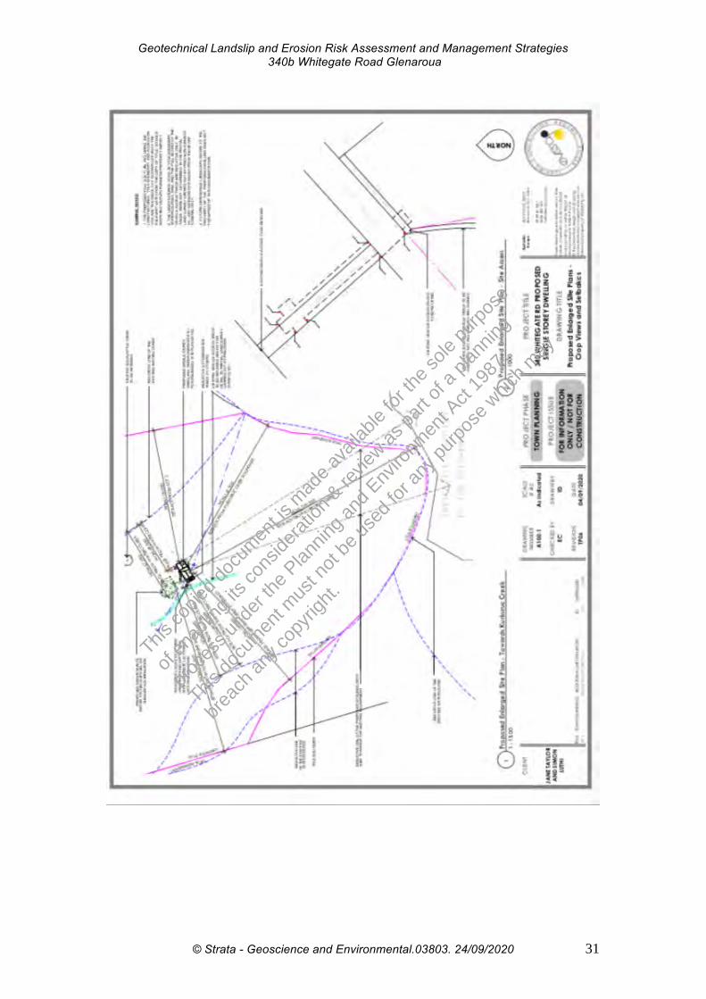
Development plan are presented in Appendix 1.
2.6 Site Investigation
Geomorphic slope factors were assessed via a visual inspection of the site, soil
and water factors were investigated by the drilling of geotechnical test bores to
2m or refusal on rock (which ever first). Soils were sampled at various depths
from the ground surface to as an initial screening investigation to inform the
requirement of follow up sampling where deep soil profiles were encountered.
Given the shallow nature of soils within the dwelling footprint, testing was not
conducted in this area.
This co
pied d
ocum
ent is
mad
e ava
ilable
for th
e sole
purpo
se
of en
ablin
g its
cons
iderat
ion & re
view as
part o
f a pl
annin
g
proce
ss un
der th
e Plan
ning a
nd Env
ironm
ent A
ct 19
87.
This do
cumen
t mus
t not
be us
ed fo
r any
purpo
se w
hich m
ay
breac
h any
copy
right.
© Strata - Geoscience and Environmental.03803. 24/09/2020 13

Geotechnical Landslip and Erosion Risk Assessment and Management Strategies 340b Whitegate Road Glenaroua
3. Results and Discussion
3.1 Field Reconnaissance
Field reconnaissance involved a site walk over to confirm geomorphology and
the drilling of geotechnical bores in proposed development areas to facilitate
soil sampling (where relevant). Logs are presented in Appendix 2.
General comments from field reconnaissance include:
o The site is moderately- steeply sloping, covered with pasture and
inferred bedrock outcroppings were observed within the localised
landscape.
o The dwelling location is on a south east sloping spur containing
north east and south west faces.
o The proposed dwelling site did not show any signs of instability or
erosion and surface bedrock outcroppings were observed.
o However, evidence of current or former erosion or slope instability
was seen in gullies approximately 100m from the proposed
dwelling location. Soils where significantly deeper in these areas
and had runoff concentrated.
o Slopes over the site are located on slopes greater than 7 degrees.
3.2 LaboratoryResults
Given the very shallow soils observed within the proposed dwelling site, soil
sampling and laboratory testing was not conducted.
3.3 Discussion
3.3.1 Wind,Sheet,Rill,TunnelandGullyErosion
Geotechnical reconnaissance found shallow loose Silts (ML) over CLAYS
(CL/CH) up to 1.0 mbgs (Appendix 2). In some areas surface bedrock was
observed. Light textured loosely packet topsoils (where present) are
susceptible to wind erosion if stripped of vegetation for prolonged periods.
This co
pied d
ocum
ent is
mad
e ava
ilable
for th
e sole
purpo
se
of en
ablin
g its
cons
iderat
ion & re
view as
part o
f a pl
annin
g
proce
ss un
der th
e Plan
ning a
nd Env
ironm
ent A
ct 19
87.
This do
cumen
t mus
t not
be us
ed fo
r any
purpo
se w
hich m
ay
breac
h any
copy
right.
© Strata - Geoscience and Environmental.03803. 24/09/2020 14

Geotechnical Landslip and Erosion Risk Assessment and Management Strategies 340b Whitegate Road Glenaroua
Whilst laboratory testing was not conducted from the dwelling site given the
very shallow soils in this area there is a risk of intercepting severely dispersive
soil phases (Class 1/2) over the site with significant amount of soil disturbance
combined with the fact that these phases are likely to vary enormously over
short distances.
Light textured topsoils where present can be eroded by wind and water if not
managed correctly. This will lead to sheet and rill erosion with the loss of topsoil
and potential sedimentation of waterways. It can also expose deeper subsoils
with dispersive phases which can lead to tunnel and gully erosion, particularly
on slopes. Active gully and tunnel erosion was observed approximately 100m
from the proposed dwelling site in areas of deeper soils on steeper slopes
where runoff is concentrated.
Given the potential presence of highly dispersive soil phases over the site, the
risk analysis presented in Section 3.4.1 has been prepared based upon the
assumption that highly dispersive phase are likely to be disturbed by the current
development plan.
3.3.2 Deep Seated Landslide,Debris,Slide/Flowand RockfallRisks
No evidence of active or former areas of slope instability were observed over
proposed building area. The majority of the site had slopes >7 degrees.
The site should have the following strategies implemented to limit risks:
• Employ deepened foundation designs into competent bedrock. This substrate is relatively shallow to the ground surface and will provide a competent and stable substrate for foundations, minimising slope instability risks to the dwelling.
• Exclude site cutting and bulk earthworks where possible or minimise when not possible.
• Revegetate immediately after soil disturbance.
• Manage soil water relations.
This co
pied d
ocum
ent is
mad
e ava
ilable
for th
e sole
purpo
se
of en
ablin
g its
cons
iderat
ion & re
view as
part o
f a pl
annin
g
proce
ss un
der th
e Plan
ning a
nd Env
ironm
ent A
ct 19
87.
This do
cumen
t mus
t not
be us
ed fo
r any
purpo
se w
hich m
ay
breac
h any
copy
right.
© Strata - Geoscience and Environmental.03803. 24/09/2020 15

Geotechnical Landslip and Erosion Risk Assessment and Management Strategies 340b Whitegate Road Glenaroua
A qualitative Geotechnical Landslip and Erosion risk assessment, in
accordance with Australian Geomechanics Society (2007) is presented in
Section 3.4.
This co
pied d
ocum
ent is
mad
e ava
ilable
for th
e sole
purpo
se
of en
ablin
g its
cons
iderat
ion & re
view as
part o
f a pl
annin
g
proce
ss un
der th
e Plan
ning a
nd Env
ironm
ent A
ct 19
87.
This do
cumen
t mus
t not
be us
ed fo
r any
purpo
se w
hich m
ay
breac
h any
copy
right.
© Strata - Geoscience and Environmental.03803. 24/09/2020 16
Geotechnical Landslip and Erosion Risk Assessment and Management Strategies 340b Whitegate Road Glenaroua
3.4.1 Erosion RiskAssessment Table 1 – Summary erosion hazards, consequences and risk, with suggested treatment options
and revised risk after treatment option implementation
Hazard: Likelihood Soil erosion of
occurrence
Rill and Sheet Erosion
Tunnel and Gully Erosion
Possible
Wind Erosion Possible
Possible
Consequencesto life and property
Medium
This co
pied d
ocum
ent is
mad
e ava
ilable
for th
e sole
purpo
se
of en
ablin
g its
cons
iderat
ion & re
view as
part o
f a pl
annin
g
proce
ss un
der th
e Plan
ning a
nd Env
ironm
ent A
ct 19
87.
This do
cumen
t mus
t not
be us
ed fo
r any
purpo
se w
hich m
ay
breac
h any
copy
right.
Medium
Major
Level of risk to life and property
Moderate
Moderate
High
Mitigation optionsto lower risk levels (see
Section 4 for further details)
Avoid excavations where possible and excavate only in dry weather where necessary.
Cover excavations as soon as possible after construction.
Chemical amelioration, re-vegetate and re-topsoil as soon as practical after disturbance
Capture and reticulate all runoff around disturbed areas Excavate only in stable weather
Cover excavations as soon as possible after construction.
Chemical amelioration, re-vegetate and re-topsoil as soon as practical after disturbance
Vegetate downslope swales (WSUD).
Avoid culverts and trenching where possible
Chemical amelioration, re-vegetate and re-topsoil. Use of weirs, rock lined swales to reduce water velocity.
Cover excavations as soon as possible after construction.
Excavate only in dry weather See Section 5 for further recommendations
Concepts and terminology from AGS (2007) Practice Note Guidelines for Landslide Risk Management
(See Appendix 3)
© Strata - Geoscience and Environmental.03803. 24/09/2020 17
Level or risk after
mitigation
Low
Low
Moderate-Low

Geotechnical Landslip and Erosion Risk Assessment and Management Strategies 340b Whitegate Road Glenaroua
3.4.2 SlopeInstabilityRiskAssessment
Table 2 –Summary of geotechnical hazards, consequences and risk, with suggested treatment
options and revised risk after treatment option implementation
Debris Slide/Slump/Creep
Deep Seated Landslide
Possible Medium Moderate
Likelihood Consequenc Likely level Level of risk Possible mitigation Hazard of es to of risk after to property options occurrence property mitigation
Unlikely Major
This co
pied d
ocum
ent is
mad
e ava
ilable
for th
e sole
purpo
se
of en
ablin
g its
cons
iderat
ion & re
view as
part o
f a pl
annin
g
proce
ss un
der th
e Plan
ning a
nd Env
ironm
ent A
ct 19
87.
This do
cumen
t mus
t not
be us
ed fo
r any
purpo
se w
hich m
ay
breac
h any
copy
right.
High
Adopt building/land application envelopes 20m buffers from areas with slopes > 7 degrees – both up and downslope where possible
Utilise deepenedfoundation designs (eg end bearing piles) in areas above this threshold
Lightweight, articulated, flexible construction methods
Adequate reticulation of all stormwater to discharge points capable of accepting 200mm/d.
Minimise/exclude bulk earthworks and site cutting
Minimise/exclude bulk earthworks and site cutting – design driveways to have flattest route across its distance.
Adequately stabilise all cuts with engineered retaining walls or Gabion Walls
Adopt building/land application envelopes 20m buffers from areas with slopes > 7 degrees – both up and downslope where possible
Utilise deepened foundation designs (eg end bearing piles) in areas above this threshold
Minimise/exclude soil disturbance and bulk earthworks
Fill batters must be adequately stabilised
Retain/promote deep rooted vegetation where it will not impact upon foundations.
Low
Low
© Strata - Geoscience and Environmental.03803. 24/09/2020 18

Geotechnical Landslip and Erosion Risk Assessment and Management Strategies 340b Whitegate Road Glenaroua
Foundations to be designed to cater for adverse soil water relations and founded on bedrock)
Lightweight, articulated, flexible construction methods
Adequate and deep upslope drainage
Irrigate wastewater downslope of all structures
Minimise/exclude bulk earthworks and site cutting – design driveways to have flattest route across its distance.
Adequately stabilise all cuts with engineered retaining walls or Gabion Walls
Rock falls and topples
Contain Medium Unlikely all liberated boulders
This co
pied d
ocum
ent is
mad
e ava
ilable
for th
e sole
purpo
se
of en
ablin
g its
cons
iderat
ion & re
view as
part o
f a pl
annin
g
proce
ss un
der th
e Plan
ning a
nd Env
ironm
ent A
ct 19
87.
This do
cumen
t mus
t not
be us
ed fo
r any
purpo
se w
hich m
ay
breac
h any
copy
right.
Low Low Concepts and terminology from AGS (2007) Practice Note Guidelines for Landslide Risk Management (See Appendix 3
*Risk needs further assessment when finalised development plan available.)
© Strata - Geoscience and Environmental.03803. 24/09/2020 19

Geotechnical Landslip and Erosion Risk Assessment and Management Strategies 340b Whitegate Road Glenaroua
4. Risk Assessment Conclusions
This investigation and risk assessment for the potential to create slope instability (landslip) over the proposed development areas has found:
• No evidence of current or former instability was observed over the proposed dwelling location.
• The largest risk associated with the creation of instability is associated with deeper soils >1m on slopes >7 degrees
• Risks to the dwelling and land application areas are low provided that all treatment measures are employed. Specifically, this involves employing deepened foundation designs into competent bedrock. This substrate is relatively shallow to the ground surface and will provide a competent and stable substrate for foundations, minimising slope instability risks to the dwelling. Further risk management of potential for slope instability can be ensured by excluding bulk earthworks and managing upslope runoff.
• If all treatment measures are employed the risk to life and property is low and tolerable.
This investigation and risk assessment for soil erosion over the proposed
development areas has found:
• No erosion was observed over the proposed dwelling site however severe tunnel and gully erosion was observed in deeper soils on steeper slopes approximately 100m from the proposed dwelling location.
• Dispersive soil phases are likely to exist over the site and have the risk of causing tunnel and gully erosion over time if inappropriately managed. The presence and severity of these dispersive phases are likely to vary enormously over short distances.
This co
pied d
ocum
ent is
mad
e ava
ilable
for th
e sole
purpo
se
of en
ablin
g its
cons
iderat
ion & re
view as
part o
f a pl
annin
g
proce
ss un
der th
e Plan
ning a
nd Env
ironm
ent A
ct 19
87.
This do
cumen
t mus
t not
be us
ed fo
r any
purpo
se w
hich m
ay
breac
h any
copy
right.
© Strata - Geoscience and Environmental.03803. 24/09/2020 20

Geotechnical Landslip and Erosion Risk Assessment and Management Strategies 340b Whitegate Road Glenaroua
• Deep sandy topsoils where disturbed present a further sheet and rill
erosion risk via wind or water.
• The risk associated with site development creating soil erosion is high
• Treatment measures MUST be adopted to limit this risk to life and
property.
This co
pied d
ocum
ent is
mad
e ava
ilable
for th
e sole
purpo
se
of en
ablin
g its
cons
iderat
ion & re
view as
part o
f a pl
annin
g
proce
ss un
der th
e Plan
ning a
nd Env
ironm
ent A
ct 19
87.
This do
cumen
t mus
t not
be us
ed fo
r any
purpo
se w
hich m
ay
breac
h any
copy
right.
© Strata - Geoscience and Environmental.03803. 24/09/2020 21

Geotechnical Landslip and Erosion Risk Assessment and Management Strategies 340b Whitegate Road Glenaroua
5. Management Strategies
5.1 Erosion RiskManagementStrategies
Given the above the following GENERAL erosion risk management strategies
are recommended to limit risk to life and property:
• Maintaining topsoils and minimising subsoil disturbance. Where
vegetation is stripped, it should be replaced or stabilised with jute
matting, hydro-seeding or similar as soon as possible after disturbance.
• Chemical amelioration of all disturbed areas using gypsum at an
application rate of 1kg/m2
• Conduct bulk earthworks throughout drier periods where possible.
• If possible do not construct culverts, trenches or drains in dispersive
soils.
• Avoid/limit bulk earthworks or construction of new dams if possible.
• Adopt the recommendations of EPA Publication 960 Guidelines for
Environmental Management – Doing it Right on Subdivisions (Appendix
3)
This co
pied d
ocum
ent is
mad
e ava
ilable
for th
e sole
purpo
se
of en
ablin
g its
cons
iderat
ion & re
view as
part o
f a pl
annin
g
proce
ss un
der th
e Plan
ning a
nd Env
ironm
ent A
ct 19
87.
This do
cumen
t mus
t not
be us
ed fo
r any
purpo
se w
hich m
ay
breac
h any
copy
right.
© Strata - Geoscience and Environmental.03803. 24/09/2020 22

Geotechnical Landslip and Erosion Risk Assessment and Management Strategies 340b Whitegate Road Glenaroua
With reference to the development plan (see Appendix 1) the following
recommendations are made:
• Roadways/driveways MUST:
o Install roading via the flattest possible routes.
o Have cambers slightly sloping down slope and roadside swales
and batters MUST be revegetated following the principles of
water sensitive urban design.
o The use of road bars and diversion mounds to channel water
away from roads is encouraged
o Subgrade MUST be compacted, treated with gypsum and a
suitable base layer must be rolled to limit infiltration into
dispersive soils under roads.
o Roadways should be completed as soon as possible after
topsoil stripping. Road routes should be stripped in stages to
limit erosion risk caused by disturbance and disturbed soil must
not be left de-vegetated for prolonged periods, especially
throughout wet periods.
o If culverts and drains are absolutely necessary ensure that they
are excavated in dispersive soils are capped with non
dispersive clays mixed with gypsum and topsoil and re –
vegetated and monitored.
o Construct rock weirs or line drains with rocks to reduce water
velocity.
o Follow the principals of water sensitive urban design
This co
pied d
ocum
ent is
mad
e ava
ilable
for th
e sole
purpo
se
of en
ablin
g its
cons
iderat
ion & re
view as
part o
f a pl
annin
g
proce
ss un
der th
e Plan
ning a
nd Env
ironm
ent A
ct 19
87.
This do
cumen
t mus
t not
be us
ed fo
r any
purpo
se w
hich m
ay
breac
h any
copy
right.
© Strata - Geoscience and Environmental.03803. 24/09/2020 23
Geotechnical Landslip and Erosion Risk Assessment and Management Strategies 340b Whitegate Road Glenaroua
• Services installation MUST:
o Avoid trenching systems and use above ground piping or aerial
cabling where possible.
o Where underground service installation is absolutely necessary
ensure dispersive soils are capped with non dispersive clays
mixed with gypsum and topsoil and re –vegetated and
monitored.
o Avoid onsite trenching systems for stormwater - construct lined
rock weirs or line drains with rocks to reduce water velocity.
o Follow the principals of water sensitive urban design for
stormwater reticulation – use grassed swales, lined weir
systems and encourage wetland to treat stormwater and reduce
water velocity.
• Future Dwellings/Outbuildings Construction Methods:
Given the presence of dispersive soils, mitigation should be undertaken as
follows:
o Cut and fill areas are to be covered with 150mm topsoil with
gypsum mixed at 1.0 kg/m2 and re-vegetated. Areas are then to
be mulched and track rolled. The areas are to be
monitored and any signs of tunnel erosion are to be rectified
immediately.
o Limit concentration of run-off from hardstands. Excavated ground
levels are to fall away from the house so that no water pools.
o Trenching in dispersive soils is to be avoided. Avoid trenching of
stormwater and water supply pipes from header tanks into the
clay layer. Lay piping scratched max 100mm deep into the topsoil
layer, cover with topsoil mounded over pipes and re-seed
immediately.
This co
pied d
ocum
ent is
mad
e ava
ilable
for th
e sole
purpo
se
of en
ablin
g its
cons
iderat
ion & re
view as
part o
f a pl
annin
g
proce
ss un
der th
e Plan
ning a
nd Env
ironm
ent A
ct 19
87.
This do
cumen
t mus
t not
be us
ed fo
r any
purpo
se w
hich m
ay
breac
h any
copy
right.
© Strata - Geoscience and Environmental.03803. 24/09/2020 24
Geotechnical Landslip and Erosion Risk Assessment and Management Strategies 340b Whitegate Road Glenaroua
• Wastewater Systems MUST;
o Be designed as an near surface system (eg sand filter, mound
or spray/drip irrigation NOT TRENCHES OR BEDS)
o Water to be treated to secondary levels
o All land application area must have vegetation maintained
o Land application envelopes must be located downslope of
building envelopes
o Underlying soils MUST be treated with Gypsum at a rate of
1Kg/m2
This co
pied d
ocum
ent is
mad
e ava
ilable
for th
e sole
purpo
se
of en
ablin
g its
cons
iderat
ion & re
view as
part o
f a pl
annin
g
proce
ss un
der th
e Plan
ning a
nd Env
ironm
ent A
ct 19
87.
This do
cumen
t mus
t not
be us
ed fo
r any
purpo
se w
hich m
ay
breac
h any
copy
right.
© Strata - Geoscience and Environmental.03803. 24/09/2020 25

Geotechnical Landslip and Erosion Risk Assessment and Management Strategies 340b Whitegate Road Glenaroua
5.2 SlopeInstabiityRiskManagementStrategies
Given the above the following GENERAL treatment measures are
recommended to limit risk to life and property from slope instability:
• Minimise/exclude bulk earthworks and site cutting – design
roading/driveways to have flattest route across its distance where
possible.
• Adequately stabilise all cuts with engineered retaining walls or Gabion
Walls
• Where this is not possible utilise the following treatment measures:
o Incorporate deepened foundation systems into competent bedrock
o Avoid trench based land application of storm or wastewater
o Adopt the recommendations of the Australian Geomechanics
Society for Good Hillside Construction Practice (2007) (Appendix
3)
This co
pied d
ocum
ent is
mad
e ava
ilable
for th
e sole
purpo
se
of en
ablin
g its
cons
iderat
ion & re
view as
part o
f a pl
annin
g
proce
ss un
der th
e Plan
ning a
nd Env
ironm
ent A
ct 19
87.
This do
cumen
t mus
t not
be us
ed fo
r any
purpo
se w
hich m
ay
breac
h any
copy
right.
© Strata - Geoscience and Environmental.03803. 24/09/2020 26
Geotechnical Landslip and Erosion Risk Assessment and Management Strategies 340b Whitegate Road Glenaroua
5.3 FurtherRecommendations
Lastly it is recommended that:
• A Soil and Water Management Plan, detailing specific treatment
measures must be commissioned.
• All treatment measures designed or installed by others MUST be ratified
by the author.
• All future development plans MUST be provided to strata to ratify
against this report. Failure to ensure this will void the modelling and
recommendations contained within this report.
• Ongoing monitoring of all works for signs of erosion must be undertaken
by owners or occupiers in conjunction with Strata Geoscience and
Environmental P/L.
Any questions or comments in relation to this investigation or its findings should
be directed towards the author.
This co
pied d
ocum
ent is
mad
e ava
ilable
for th
e sole
purpo
se
of en
ablin
g its
cons
iderat
ion & re
view as
part o
f a pl
annin
g
proce
ss un
der th
e Plan
ning a
nd Env
ironm
ent A
ct 19
87.
This do
cumen
t mus
t not
be us
ed fo
r any
purpo
se w
hich m
ay
breac
h any
copy
right.
S Nielsen MEngSc CPSS-2 Director Strata Geoscience and Environmental Pty Ltd E:[email protected]
© Strata - Geoscience and Environmental.03803. 24/09/2020 27

Geotechnical Landslip and Erosion Risk Assessment and Management Strategies 340b Whitegate Road Glenaroua
6. References
• Standards Australia (1993) AS1726-1993 Geotechnical Site
Investigations
• Standards Australia (2004) AS/NZS4360 - Risk Management
• Standards Australia (1997) AS3798 “Guidelines for Earthworks on
commercial and residential subdivision”
• EPA Publication 960 Guidelines for Environmental Management – Doing
it Right on Subdivisions
• East Gippsland Soil Erosion Management Plan
• Australian Geomechanics Society (2007) Landslide Risk Management.
Australian Geomechanics 42(1) March 2007.
• Mazengarb (2010) Landslide Risk Modelling. MRT
This co
pied d
ocum
ent is
mad
e ava
ilable
for th
e sole
purpo
se
of en
ablin
g its
cons
iderat
ion & re
view as
part o
f a pl
annin
g
proce
ss un
der th
e Plan
ning a
nd Env
ironm
ent A
ct 19
87.
This do
cumen
t mus
t not
be us
ed fo
r any
purpo
se w
hich m
ay
breac
h any
copy
right.
© Strata - Geoscience and Environmental.03803. 24/09/2020 28

Geotechnical Landslip and Erosion Risk Assessment and Management Strategies 340b Whitegate Road Glenaroua
7. Appendices
This report contains the following appendices:
Appendix 1 Development Plans Appendix 2 Indicative Bore Logs from Proposed Development Area Appendix 3 Extracts EPA, Aust Geomechanics Guidelines (2007) Appendix 4 Terms and Conditions
All appendices must accompany this report and be reproduced faithfully in full colour.
This co
pied d
ocum
ent is
mad
e ava
ilable
for th
e sole
purpo
se
of en
ablin
g its
cons
iderat
ion & re
view as
part o
f a pl
annin
g
proce
ss un
der th
e Plan
ning a
nd Env
ironm
ent A
ct 19
87.
This do
cumen
t mus
t not
be us
ed fo
r any
purpo
se w
hich m
ay
breac
h any
copy
right.
© Strata - Geoscience and Environmental.03803. 24/09/2020 29

Geotechnical Landslip and Erosion Risk Assessment and Management Strategies 340b Whitegate Road Glenaroua
Appendix1 DevelopmentPlans
This co
pied d
ocum
ent is
mad
e ava
ilable
for th
e sole
purpo
se
of en
ablin
g its
cons
iderat
ion & re
view as
part o
f a pl
annin
g
proce
ss un
der th
e Plan
ning a
nd Env
ironm
ent A
ct 19
87.
This do
cumen
t mus
t not
be us
ed fo
r any
purpo
se w
hich m
ay
breac
h any
copy
right.
© Strata - Geoscience and Environmental.03803. 24/09/2020 30
Geotechnical Landslip and Erosion Risk Assessment and Management Strategies 340b Whitegate Road Glenaroua
This co
pied d
ocum
ent is
mad
e ava
ilable
for th
e sole
purpo
se
of en
ablin
g its
cons
iderat
ion & re
view as
part o
f a pl
annin
g
proce
ss un
der th
e Plan
ning a
nd Env
ironm
ent A
ct 19
87.
This do
cumen
t mus
t not
be us
ed fo
r any
purpo
se w
hich m
ay
breac
h any
copy
right.
© Strata - Geoscience and Environmental.03803. 24/09/2020 31

Geotechnical Landslip and Erosion Risk Assessment and Management Strategies 340b Whitegate Road Glenaroua
Appendix2 Indicative BoreLogs fromProposedDwellingLocation
This co
pied d
ocum
ent is
mad
e ava
ilable
for th
e sole
purpo
se
of en
ablin
g its
cons
iderat
ion & re
view as
part o
f a pl
annin
g
proce
ss un
der th
e Plan
ning a
nd Env
ironm
ent A
ct 19
87.
This do
cumen
t mus
t not
be us
ed fo
r any
purpo
se w
hich m
ay
breac
h any
copy
right.
© Strata - Geoscience and Environmental.03803. 24/09/2020 32

Geotechnical Landslip and Erosion Risk Assessment and Management Strategies 340b Whitegate Road Glenaroua
This co
pied d
ocum
ent is
mad
e ava
ilable
for th
e sole
purpo
se
of en
ablin
g its
cons
iderat
ion & re
view as
part o
f a pl
annin
g
proce
ss un
der th
e Plan
ning a
nd Env
ironm
ent A
ct 19
87.
This do
cumen
t mus
t not
be us
ed fo
r any
purpo
se w
hich m
ay
breac
h any
copy
right.
© Strata - Geoscience and Environmental.03803. 24/09/2020 33

Geotechnical Landslip and Erosion Risk Assessment and Management Strategies 340b Whitegate Road Glenaroua
Appendix 3 Extracts from EPA Publication 960
This co
pied d
ocum
ent is
mad
e ava
ilable
for th
e sole
purpo
se
of en
ablin
g its
cons
iderat
ion & re
view as
part o
f a pl
annin
g
proce
ss un
der th
e Plan
ning a
nd Env
ironm
ent A
ct 19
87.
This do
cumen
t mus
t not
be us
ed fo
r any
purpo
se w
hich m
ay
breac
h any
copy
right.
© Strata - Geoscience and Environmental.03803. 24/09/2020 34

Geotechnical Landslip and Erosion Risk Assessment and Management Strategies 340b Whitegate Road Glenaroua
This co
pied d
ocum
ent is
mad
e ava
ilable
for th
e sole
purpo
se
of en
ablin
g its
cons
iderat
ion & re
view as
part o
f a pl
annin
g
proce
ss un
der th
e Plan
ning a
nd Env
ironm
ent A
ct 19
87.
This do
cumen
t mus
t not
be us
ed fo
r any
purpo
se w
hich m
ay
breac
h any
copy
right.
© Strata - Geoscience and Environmental.03803. 24/09/2020 35

Geotechnical Landslip and Erosion Risk Assessment and Management Strategies 340b Whitegate Road Glenaroua
This co
pied d
ocum
ent is
mad
e ava
ilable
for th
e sole
purpo
se
of en
ablin
g its
cons
iderat
ion & re
view as
part o
f a pl
annin
g
proce
ss un
der th
e Plan
ning a
nd Env
ironm
ent A
ct 19
87.
This do
cumen
t mus
t not
be us
ed fo
r any
purpo
se w
hich m
ay
breac
h any
copy
right.
© Strata - Geoscience and Environmental.03803. 24/09/2020 36

Geotechnical Landslip and Erosion Risk Assessment and Management Strategies 340b Whitegate Road Glenaroua
This co
pied d
ocum
ent is
mad
e ava
ilable
for th
e sole
purpo
se
of en
ablin
g its
cons
iderat
ion & re
view as
part o
f a pl
annin
g
proce
ss un
der th
e Plan
ning a
nd Env
ironm
ent A
ct 19
87.
This do
cumen
t mus
t not
be us
ed fo
r any
purpo
se w
hich m
ay
breac
h any
copy
right.
© Strata - Geoscience and Environmental.03803. 24/09/2020 37

Geotechnical Landslip and Erosion Risk Assessment and Management Strategies 340b Whitegate Road Glenaroua
This co
pied d
ocum
ent is
mad
e ava
ilable
for th
e sole
purpo
se
of en
ablin
g its
cons
iderat
ion & re
view as
part o
f a pl
annin
g
proce
ss un
der th
e Plan
ning a
nd Env
ironm
ent A
ct 19
87.
This do
cumen
t mus
t not
be us
ed fo
r any
purpo
se w
hich m
ay
breac
h any
copy
right.
© Strata - Geoscience and Environmental.03803. 24/09/2020 38

Geotechnical Landslip and Erosion Risk Assessment and Management Strategies 340b Whitegate Road Glenaroua
This co
pied d
ocum
ent is
mad
e ava
ilable
for th
e sole
purpo
se
of en
ablin
g its
cons
iderat
ion & re
view as
part o
f a pl
annin
g
proce
ss un
der th
e Plan
ning a
nd Env
ironm
ent A
ct 19
87.
This do
cumen
t mus
t not
be us
ed fo
r any
purpo
se w
hich m
ay
breac
h any
copy
right.
© Strata - Geoscience and Environmental.03803. 24/09/2020 39

Geotechnical Landslip and Erosion Risk Assessment and Management Strategies 340b Whitegate Road Glenaroua
This co
pied d
ocum
ent is
mad
e ava
ilable
for th
e sole
purpo
se
of en
ablin
g its
cons
iderat
ion & re
view as
part o
f a pl
annin
g
proce
ss un
der th
e Plan
ning a
nd Env
ironm
ent A
ct 19
87.
This do
cumen
t mus
t not
be us
ed fo
r any
purpo
se w
hich m
ay
breac
h any
copy
right.
© Strata - Geoscience and Environmental.03803. 24/09/2020 40

Geotechnical Landslip and Erosion Risk Assessment and Management Strategies 340b Whitegate Road Glenaroua
This co
pied d
ocum
ent is
mad
e ava
ilable
for th
e sole
purpo
se
of en
ablin
g its
cons
iderat
ion & re
view as
part o
f a pl
annin
g
proce
ss un
der th
e Plan
ning a
nd Env
ironm
ent A
ct 19
87.
This do
cumen
t mus
t not
be us
ed fo
r any
purpo
se w
hich m
ay
breac
h any
copy
right.
© Strata - Geoscience and Environmental.03803. 24/09/2020 41

Geotechnical Landslip and Erosion Risk Assessment and Management Strategies 340b Whitegate Road Glenaroua
This co
pied d
ocum
ent is
mad
e ava
ilable
for th
e sole
purpo
se
of en
ablin
g its
cons
iderat
ion & re
view as
part o
f a pl
annin
g
proce
ss un
der th
e Plan
ning a
nd Env
ironm
ent A
ct 19
87.
This do
cumen
t mus
t not
be us
ed fo
r any
purpo
se w
hich m
ay
breac
h any
copy
right.
© Strata - Geoscience and Environmental.03803. 24/09/2020 42
Geotechnical Landslip and Erosion Risk Assessment and Management Strategies 340b Whitegate Road Glenaroua
This co
pied d
ocum
ent is
mad
e ava
ilable
for th
e sole
purpo
se
of en
ablin
g its
cons
iderat
ion & re
view as
part o
f a pl
annin
g
proce
ss un
der th
e Plan
ning a
nd Env
ironm
ent A
ct 19
87.
This do
cumen
t mus
t not
be us
ed fo
r any
purpo
se w
hich m
ay
breac
h any
copy
right.
© Strata - Geoscience and Environmental.03803. 24/09/2020 43

Geotechnical Landslip and Erosion Risk Assessment and Management Strategies 340b Whitegate Road Glenaroua
Extracts From Australian Geomechanics Journals (2007)
This co
pied d
ocum
ent is
mad
e ava
ilable
for th
e sole
purpo
se
of en
ablin
g its
cons
iderat
ion & re
view as
part o
f a pl
annin
g
proce
ss un
der th
e Plan
ning a
nd Env
ironm
ent A
ct 19
87.
This do
cumen
t mus
t not
be us
ed fo
r any
purpo
se w
hich m
ay
breac
h any
copy
right.
© Strata - Geoscience and Environmental.03803. 24/09/2020 44

Geotechnical Landslip and Erosion Risk Assessment and Management Strategies 340b Whitegate Road Glenaroua
This co
pied d
ocum
ent is
mad
e ava
ilable
for th
e sole
purpo
se
of en
ablin
g its
cons
iderat
ion & re
view as
part o
f a pl
annin
g
proce
ss un
der th
e Plan
ning a
nd Env
ironm
ent A
ct 19
87.
This do
cumen
t mus
t not
be us
ed fo
r any
purpo
se w
hich m
ay
breac
h any
copy
right.
© Strata - Geoscience and Environmental.03803. 24/09/2020 45

Geotechnical Landslip and Erosion Risk Assessment and Management Strategies 340b Whitegate Road Glenaroua
This co
pied d
ocum
ent is
mad
e ava
ilable
for th
e sole
purpo
se
of en
ablin
g its
cons
iderat
ion & re
view as
part o
f a pl
annin
g
proce
ss un
der th
e Plan
ning a
nd Env
ironm
ent A
ct 19
87.
This do
cumen
t mus
t not
be us
ed fo
r any
purpo
se w
hich m
ay
breac
h any
copy
right.
© Strata - Geoscience and Environmental.03803. 24/09/2020 46
Geotechnical Landslip and Erosion Risk Assessment and Management Strategies 340b Whitegate Road Glenaroua
This co
pied d
ocum
ent is
mad
e ava
ilable
for th
e sole
purpo
se
of en
ablin
g its
cons
iderat
ion & re
view as
part o
f a pl
annin
g
proce
ss un
der th
e Plan
ning a
nd Env
ironm
ent A
ct 19
87.
This do
cumen
t mus
t not
be us
ed fo
r any
purpo
se w
hich m
ay
breac
h any
copy
right.
© Strata - Geoscience and Environmental.03803. 24/09/2020 47

Geotechnical Landslip and Erosion Risk Assessment and Management Strategies 340b Whitegate Road Glenaroua
Appendix 4 Terms and Conditions
Scope of Work These Terms and Conditions apply to any services provided to you (“the Client”) by Strata Geoscience and Environmental Pty Ltd (“Strata”). By continuing to instruct Strata to act after receiving the Terms and Conditions or not objecting to any of the Terms and Conditions the Client agrees to be bound by these Terms and Conditions, and any other terms and conditions supplied by Strata from time to time at Strata’s sole and absolute discretion. The scope of the services provided to the Client by Strata is limited to the services and specified purpose agreed between Strata and the Client and set out in the correspondence to which this document is enclosed or annexed (“the Services”). Strata does not purport to advise beyond the Services.
Third Parties The Services are supplied to the Client for the sole benefit of the Client and must not be relied upon by any person or entity other than the Client. Strata is not responsible or liable to any third party. All parties other than the Client are advised to seek their own advice before proceeding with any course of action.
Provision of Information The Client is responsible for the provision of all legal, survey and other particulars concerning the site on which Strata is providing the Services, including particulars of existing structures and services and features for the site and for adjoining sites and structures. The Client is also responsible for the provision of specialised services not provided by Strata. If Strata obtains these particulars or specialised services on the instruction of the Client, Strata does so as agent of the Client and at the Client's expense. Strata is not obliged to confirm the accuracy and completeness of information supplied by the Client or any third party service provider. The Client is responsible for the accuracy and completeness of all particulars or services provided by the Client or obtained on the Client’s behalf. Strata is not liable, and accepts no responsibility, for any claim, demand, charge, loss, damage, injury or expense whatsoever suffered by the Client or any other person or entity resulting from the failure of the Client or third party to provide accurate and complete information. In the event additional information becomes available to the Client, the Client must inform Strata in writing of that information as soon as possible. Further advice will be provided at the Client’s cost. Any report is prepared on the assumption that the instructions and information supplied to Strata has been provided in good faith and is all of the information relevant to the provision of the Services by Strata. Strata is not liable, and accepts no responsibility, for any claim, demand, charge, loss, damage, injury or expense whatsoever if Strata has been supplied with insufficient, incorrect, incomplete, false or misleading information.
IntegrityAny report provided by Strata presents the findings of the site assessment. While all reasonable care is taken when conducting site investigations and reporting to the Client, Strata does not warrant that the information contained in any report is free from errors or omissions. Strata is not liable, and accepts no responsibility, for any claim, demand, charge, loss, damage, injury or expense whatsoever resulting from errors in a report. Any report should be read in its entirety, inclusive of any summary and annexures. Strata does not accept any responsibility where part of any report is relied upon without reference to the full report.
Project Specific Criteria Any report provided by Strata will be prepared on the basis of unique project development plans which apply only to the site that is being investigated. Reports provided by Strata do not apply to any project other than that originally specified by the Client to Strata. The Report must not be used or relied upon if any changes to the project are made. The Client should engage Strata to further advise on the effect of any change to the project. Further advice will be provided at the Client’s cost. Strata is not liable, and accepts no responsibility, for any claim, demand, charge, loss, damage, injury or expense whatsoever where any change to the project is made without obtaining a further written report from Strata. Changes to the project may include, but are not limited to, changes to the investigated site or neighbouring sites, for instance, variation of the location of proposed building envelopes/footprints, changes to building design which may impact upon building settlement or slope stability, or changes to earthworks, including removal (site cutting) or deposition of sediments or rock from the site.
Subsurface Variations with Time Any report provided by Strata is based upon subsurface conditions encountered at the time of the investigation. Conditions can and do change significantly and unexpectedly over a short period of time. For example groundwater levels may fluctuate over time, affecting latent soil bearing capacity and ex-situ/insitu fill sediments may be placed/removed from the site. Changes to the subsurface conditions that were encountered at the time of the investigation void all recommendations made by Strata in any report. Strata is not liable, and accepts no responsibility, for any claim, demand, charge, loss, damage, injury or expense whatsoever resulting from any change to the subsurface conditions that were encountered at the time of the investigation. In the event of a delay in the commencement of a project or if additional information becomes available to the Client about a change in conditions
This co
pied d
ocum
ent is
mad
e ava
ilable
for th
e sole
purpo
se
of en
ablin
g its
cons
iderat
ion & re
view as
part o
f a pl
annin
g
proce
ss un
der th
e Plan
ning a
nd Env
ironm
ent A
ct 19
87.
This do
cumen
t mus
t not
be us
ed fo
r any
purpo
se w
hich m
ay
breac
h any
copy
right.
© Strata - Geoscience and Environmental.03803. 24/09/2020 48

Geotechnical Landslip and Erosion Risk Assessment and Management Strategies 340b Whitegate Road Glenaroua
becomes available to the Client, the Client should engage Strata to make a further investigation to ensure that the conditions initially encountered still exist. Further advice will be provided at the Client’s cost. Without limiting the generality of the above statement, Strata does not accept liability where any report is relied upon after three months from the date of the report, (unless otherwise provided in the report or required by the Australian Standard which the report purports to comply with), or the date when the Client becomes aware of any change in condition. Any report should be reviewed regularly to ensure that it continues to be accurate and further advice requested from Strata where applicable.
InterpretationSite investigation identifies subsurface conditions only at the discrete points of geotechnical drilling, and at the time of drilling. All data received from the geotechnical drilling is interpreted to report to the Client about overall site conditions as well as their anticipated impact upon the specific project. Actual site conditions may vary from those inferred to exist as it is virtually impossible to provide a definitive subsurface profile which accounts for all the possible variability inherent in earth materials. This is particularly pertinent to some weathered sedimentary geologies or colluvial/alluvial clast deposits which may show significant variability in depth to refusal over a development area. Rock incongruities such as joints, dips or faults may also result in subsurface variability. Soil depths and composition can vary due to natural and anthopogenic processes. Variability may lead to differences between the design depth of bored/driven piers compared with the actual depth of individual piers constructed onsite. It may also affect the founding depth of conventional strip, pier and beam or slab footings, which may result in increased costs associated with excavation (particularly of rock) or materials costs of foundations. Founding surface inspections should be commissioned by the Client prior to foundation construction to verify the results of initial site characterisation. Strata is not liable, and accepts no responsibility, for any claim, demand, charge, loss, damage, injury or expense whatsoever resulting from any variation from the site conditions inferred to exist.
Strata is not responsible for the interpretation of site data or report findings by other parties, including parties involved in the design and construction process. The Client must seek advice from Strata about the interpretation of the site data or report.
Report Recommendations Any report recommendations provided by Strata are only preliminary. A report is based upon the assumption that the site conditions as revealed through selective point sampling are indicative of actual conditions throughout an area. This assumption cannot be substantiated until earthworks and/or foundation construction is almost complete. Where variations in conditions are encountered, Strata should be engaged to provide further advice. Further advice will be provided at the Client’s cost. Strata is not liable, and accepts no responsibility, for any claim, demand, charge, loss, damage, injury or expense whatsoever if the results of selective point sampling are not indicative of actual conditions throughout an area or if the Client becomes aware of variations in conditions and does not engage Strata for further advice.
Geo-environmental Considerations Where onsite wastewater site investigation and land application system designs are provided by Strata, reasonable effort will be made to minimise environmental risks associated with the disposal of effluent within site boundaries with respect to relevant Australian guidelines and industry best practise at the time of investigation. Strata is not liable, and accepts no responsibility, for any claim, demand, charge, loss, damage, injury or expense whatsoever resulting from changes to either the project or site conditions that affect the onsite wastewater land application system’s ability to safely dispose of modelled wastewater flows.
Strata does not guarantee septic trench and bed design life beyond 10 years from installation, given the influence various household chemicals have on soil structural decline and premature trench failure in some soil types. Strata is not liable, and accepts no responsibility, for poor system performance where the Client cannot show that septic tanks have been de-sludged every three years or AWTS systems have been serviced in compliance with the manufacturer’s recommendations. Strata is not liable, and accepts no responsibility, for any loss associated with the selection of inappropriate plants for irrigation areas. Strata is not liable, and accepts no responsibility, for any expense whatsoever or loss associated with modification of design works requested by the permit authority. Strata is not liable and accepts no responsibility for any loss or poor system performance where both interim and final inspections are not commissioned throughout system construction.
Strata does not consider site contamination, unless the Client specifically instructs Strata to consider the site contamination in writing. If a request is made by the Client to consider site contamination, Strata will provide additional terms and conditions that will apply to the engagement.
Copyright and Use of Documents Copyright in all drawings, reports, specifications, calculations and other documents provided by Strata or its employees in connection with the Services remain vested in Strata. The Client has a licence to use the documents for the purpose of completing the project. However, the Client must not otherwise use the documents, make copies of the documents or amend the documents unless express approval in writing is given in advance by Strata. The Client must not publish or allow to be published, in whole or in part, any document provided by Strata or the name or professional affiliations of Strata, without first obtaining the written consent of Strata as to the form and context in which it is to appear.
If, during the course of providing the Services, Strata develops, discovers or first reduces to practice a concept, product or process which is capable of being patented then such concept, product or process is and remains the property of Strata and:
(a) the Client must not use, infringe or otherwise appropriate the same other than for the purpose of the project without first obtaining the written consent of Strata; and
This co
pied d
ocum
ent is
mad
e ava
ilable
for th
e sole
purpo
se
of en
ablin
g its
cons
iderat
ion & re
view as
part o
f a pl
annin
g
proce
ss un
der th
e Plan
ning a
nd Env
ironm
ent A
ct 19
87.
This do
cumen
t mus
t not
be us
ed fo
r any
purpo
se w
hich m
ay
breac
h any
copy
right.
© Strata - Geoscience and Environmental.03803. 24/09/2020 49
Geotechnical Landslip and Erosion Risk Assessment and Management Strategies 340b Whitegate Road Glenaroua
(b) the Client is entitled to a royalty free licence to use the same during the life of the works comprising the project.
Digital Copies of ReportIf any report is provided to the Client in an electronic copy except directly from Strata, the Client should verify the report contents with Strata to ensure they have not been altered or varied from the report provided by Strata.
This co
pied d
ocum
ent is
mad
e ava
ilable
for th
e sole
purpo
se
of en
ablin
g its
cons
iderat
ion & re
view as
part o
f a pl
annin
g
proce
ss un
der th
e Plan
ning a
nd Env
ironm
ent A
ct 19
87.
This do
cumen
t mus
t not
be us
ed fo
r any
purpo
se w
hich m
ay
breac
h any
copy
right.
© Strata - Geoscience and Environmental.03803. 24/09/2020 50

This co
pied d
ocum
ent is
mad
e ava
ilable
for th
e sole
purpo
se
of en
ablin
g its
cons
iderat
ion & re
view as
part o
f a pl
annin
g
proce
ss un
der th
e Plan
ning a
nd Env
ironm
ent A
ct 19
87.
This do
cumen
t mus
t not
be us
ed fo
r any
purpo
se w
hich m
ay
breac
h any
copy
right.
Land Capability Assessment and Onsite Wastewater System Design for
Lot 3 340B Whitegate Road Glenaroua
January 2020

LCA and Onsite System Design for Lot 3 340b Whitegate Road Glenaroua
Important Notes:
This co
pied d
ocum
ent is
mad
e ava
ilable
for th
e sole
purpo
se
of en
ablin
g its
cons
iderat
ion & re
view as
part o
f a pl
annin
g
proce
ss un
der th
e Plan
ning a
nd Env
ironm
ent A
ct 19
87.
This do
cumen
t mus
t not
be us
ed fo
r any
purpo
se w
hich m
ay
breac
h any
copy
right.
The author, Strata Geoscience and Environmental, gives permission for this report to
be copied and distributed to interested parties only if it is reproduced in colour and in
full including all appendicies. No responsibility is taken for the contents and
recommendations of this report if it is not reproduced as requested.
Strata Geoscience and Environmental reserves the right to submit this report the
relevant regulatory agencies where it has a responsibility to do so.
© Strata - Geoscience and Environmental. Report 03496 14/01/2020 2

LCA and Onsite System Design for Lot 3 340b Whitegate Road Glenaroua
1. Introduction
Strata Geoscience and Environmental Pty Ltd was commissioned to perform a limited scope Land Capability Assessment for:
Table 1 : Site and Client Details Client/Agent Simon Luthi Site Address Lot 3 340b Whitegate Road Glenaroua
(see Site Plan) Nature of Development New dwelling
This co
pied d
ocum
ent is
mad
e ava
ilable
for th
e sole
purpo
se
of en
ablin
g its
cons
iderat
ion & re
view as
part o
f a pl
annin
g
proce
ss un
der th
e Plan
ning a
nd Env
ironm
ent A
ct 19
87.
This do
cumen
t mus
t not
be us
ed fo
r any
purpo
se w
hich m
ay
breac
h any
copy
right.
The investigation was conducted based upon specific development plans
supplied by the client (Figures 2&3) and with reference to the following
documents:
1. EPA Victoria (2016) Code of Practice for Onsite Wastewater Management
2. Australian Standard AS1547-2012 Onsite Wastewater Management
The investigation also follows the principles outlined in:
1. 2006 MAV & DSE Model LCA Report
2. EPA Publication 746.1 Guidelines for Land Capability Assessment
3. MAV DEPI & EPA 2014 Land Capability Assessment Framework
4. AS1726-1993 Geotechnical Site Investigations.
2. Description of the Development
Table 2 Site Description
Site Address Lot 3 340b Whitegate Road Glenaroua
Owner/Developer/Agent Simon Luthi Address As above Council Area Mitchell Zoning Fz Allotment Size 41 Ha approx. Anticipated Wastewater Load Up to 450L/D (See Section 6) Availability of Sewer Unsewered and likely to be
unsewered in mid term
© Strata - Geoscience and Environmental. Report 03496 14/01/2020 3

LCA and Onsite System Design for Lot 3 340b Whitegate Road Glenaroua
3. Site Plans and Key Site Features
A range of soil and landscape features were assessed for their potential to
impact upon land application area siting and level of wastewater treatment
required over the site. Figures 1-2 give locality and proposed site plans
respectively whilst Table 3 summarises key features as in relation to effluent
management over the site.
This co
pied d
ocum
ent is
mad
e ava
ilable
for th
e sole
purpo
se
of en
ablin
g its
cons
iderat
ion & re
view as
part o
f a pl
annin
g
proce
ss un
der th
e Plan
ning a
nd Env
ironm
ent A
ct 19
87.
This do
cumen
t mus
t not
be us
ed fo
r any
purpo
se w
hich m
ay
breac
h any
copy
right.
© Strata - Geoscience and Environmental. Report 03496 14/01/2020 4

LCA and Onsite System Design for Lot 3 340b Whitegate Road Glenaroua
Figure 1 Locality Plan
This co
pied d
ocum
ent is
mad
e ava
ilable
for th
e sole
purpo
se
of en
ablin
g its
cons
iderat
ion & re
view as
part o
f a pl
annin
g
proce
ss un
der th
e Plan
ning a
nd Env
ironm
ent A
ct 19
87.
This do
cumen
t mus
t not
be us
ed fo
r any
purpo
se w
hich m
ay
breac
h any
copy
right.
© Strata - Geoscience and Environmental. Report 03496 14/01/2020 5
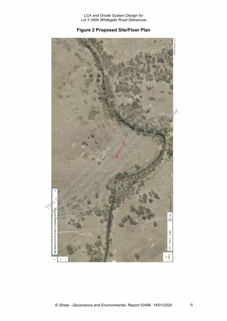
LCA and Onsite System Design for Lot 3 340b Whitegate Road Glenaroua
Figure 2 Proposed Site/Floor Plan
This co
pied d
ocum
ent is
mad
e ava
ilable
for th
e sole
purpo
se
of en
ablin
g its
cons
iderat
ion & re
view as
part o
f a pl
annin
g
proce
ss un
der th
e Plan
ning a
nd Env
ironm
ent A
ct 19
87.
This do
cumen
t mus
t not
be us
ed fo
r any
purpo
se w
hich m
ay
breac
h any
copy
right.
© Strata - Geoscience and Environmental. Report 03496 14/01/2020 6
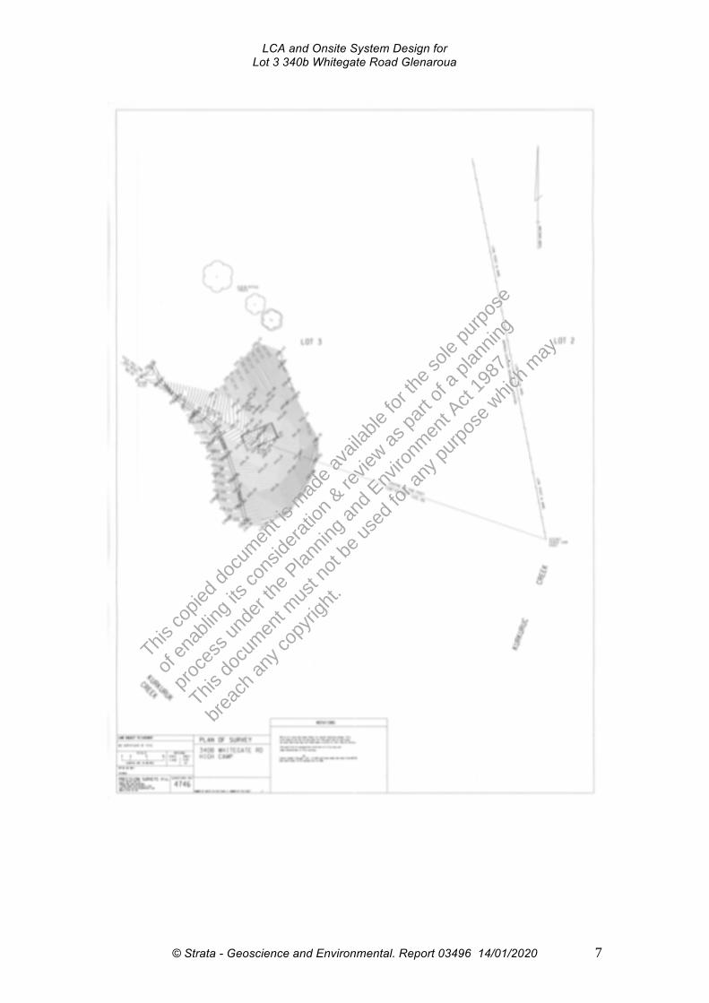
LCA and Onsite System Design for Lot 3 340b Whitegate Road Glenaroua
This co
pied d
ocum
ent is
mad
e ava
ilable
for th
e sole
purpo
se
of en
ablin
g its
cons
iderat
ion & re
view as
part o
f a pl
annin
g
proce
ss un
der th
e Plan
ning a
nd Env
ironm
ent A
ct 19
87.
This do
cumen
t mus
t not
be us
ed fo
r any
purpo
se w
hich m
ay
breac
h any
copy
right.
© Strata - Geoscience and Environmental. Report 03496 14/01/2020 7

LCA and Onsite System Design for Lot 3 340b Whitegate Road Glenaroua
Table 3 Site Features Climate The nearest weather station with long term data is the High Camp Station
with a mean annual rainfall of 620 mm (BOM 2019). The region has a near Mediterranean climate with maximum temperatures and minimum rainfall in the summer.
Exposure The site is relatively shielded with exposure to winds which predominate from the NW/SW directions
Vegetation Grass, Trees
Landform Slope
Slope Moderate
Fill No fill/disturbed soils evident in proposed land application areas
Rocks and Rock Outcrops
Surface rock outcroppings
Erosion Potential Tunnel and gully erosion evident
Surface Water >30m
Flood Potential Unknown Stormwater Run-on and Upslope Seepage
Seepage over subsoils likely
Groundwater Not encountered
Site Drainage and Subsurface Drainage
The site receives minimal run on and does not show signs of springs or other areas of ephemeral subsurface water retention. Given clay subsoils perched watertable may exist in some areas of the site
Recommended Buffer Distances
Given the significant land area, all buffer distances as stipulated in EPA (2016) are achievable.
Available Land Application Area
There is surplus space to land application area requirements
This co
pied d
ocum
ent is
mad
e ava
ilable
for th
e sole
purpo
se
of en
ablin
g its
cons
iderat
ion & re
view as
part o
f a pl
annin
g
proce
ss un
der th
e Plan
ning a
nd Env
ironm
ent A
ct 19
87.
This do
cumen
t mus
t not
be us
ed fo
r any
purpo
se w
hich m
ay
breac
h any
copy
right.
© Strata - Geoscience and Environmental. Report 03496 14/01/2020 8

LCA and Onsite System Design for Lot 3 340b Whitegate Road Glenaroua
4. Soil Assessment and Constraints
Soils have been assessed for their suitability for onsite wastewater
management through both desktop review and intrusive field investigation.
Field investigation consisted of drilling soil bores using a 50mm soil probe to
1.5m or refusal on rock with retrieval of undisturbed soil cores for logging,
sampling and testing for pH, EC, CEC, Emerson Class.
Bore logs and soil permeability data/soil test results (where relevant) are
presented in Appendix 1. As a general comment soil appeared to be relatively
uniform across the proposed development area with Clayey SANDS (SC)
grading to Clayey SILTS (ML) /Silty CLAYS (CL) subsoils.
With reference to the classification system of Isbell (2002) soils are classified
as Brown Sodosols being duplex soils with sodic phases. Soils will exhibit
duplex profiles with lighter Clayey SAND (SC) grading to Silty CLAYS
(CL/CH)/Clayey SILTS (ML) at variable depths from the existing ground
surface. Subsoils clays will exhibit a moderate structure and will show the
existence of vertical macropores throughout drier periods, significantly
increasing their unsaturated hydraulic conductivities. Subsoils will show
moderate to high cation exchange complex for the absorption of nutrients, may
contain dispersive phases and a slightly acidic pH trend.
This co
pied d
ocum
ent is
mad
e ava
ilable
for th
e sole
purpo
se
of en
ablin
g its
cons
iderat
ion & re
view as
part o
f a pl
annin
g
proce
ss un
der th
e Plan
ning a
nd Env
ironm
ent A
ct 19
87.
This do
cumen
t mus
t not
be us
ed fo
r any
purpo
se w
hich m
ay
breac
h any
copy
right.
© Strata - Geoscience and Environmental. Report 03496 14/01/2020 9
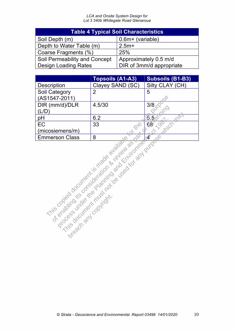
LCA and Onsite System Design for Lot 3 340b Whitegate Road Glenaroua
Table 4 Typical Soil Characteristics
Soil Depth (m) 0.6m+ (variable) Depth to Water Table (m) 2.5m+ Coarse Fragments (%) 25% Soil Permeability and Concept Design Loading Rates
Approximately 0.5 m/d DIR of 3mm/d appropriate
Topsoils (A1-A3) Subsoils (B1-B3) Description Clayey SAND (SC) Silty CLAY (CH) Soil Category (AS1547-2011)
2 5
DIR (mm/d)/DLR (L/D)
4.5/30 3/8
pH 6.2 5.5 EC (micosiemens/m)
33 68
Emmerson Class 8 4
This co
pied d
ocum
ent is
mad
e ava
ilable
for th
e sole
purpo
se
of en
ablin
g its
cons
iderat
ion & re
view as
part o
f a pl
annin
g
proce
ss un
der th
e Plan
ning a
nd Env
ironm
ent A
ct 19
87.
This do
cumen
t mus
t not
be us
ed fo
r any
purpo
se w
hich m
ay
breac
h any
copy
right.
© Strata - Geoscience and Environmental. Report 03496 14/01/2020 10
LCA and Onsite System Design for Lot 3 340b Whitegate Road Glenaroua
5. Land Capability Assessment Matrix 5.1 Assessment Matrices
Referring to MAV & DSE (2006), EPA Victoria Publication 746.1 Land
Capability Assessment for Onsite Domestic Wastewater Management and
MAV DEPI & EPA 2014 Land Capability Assessment Framework, a qualitative
LCA assessment table have been produced for the site.
This co
pied d
ocum
ent is
mad
e ava
ilable
for th
e sole
purpo
se
of en
ablin
g its
cons
iderat
ion & re
view as
part o
f a pl
annin
g
proce
ss un
der th
e Plan
ning a
nd Env
ironm
ent A
ct 19
87.
This do
cumen
t mus
t not
be us
ed fo
r any
purpo
se w
hich m
ay
breac
h any
copy
right.
© Strata - Geoscience and Environmental. Report 03496 14/01/2020 11

Table 6: Risk Assessment of Site Characteristics (MAV, DEPI, EPA 2014)
Characteristic
Level of Constraint Assessed Level of
Constraint for Site and Mitigation if
required
Nil or Minor Moderate Major
Aspect (affects solar radiation received)
North / North-East / North-West
East / West / South-East / South-West South
Minor
Climate (difference between annual rainfall and pan evaporation)
Excess of evaporation over rainfall in the wettest months
Rainfall approximates to evaporation
Excess of rainfall over evaporation in the wettest months
Moderate
Erosion 1
(or potential for erosion)
Nil or minor Moderate Severe Major – drip irrigate into topsoils
Exposure to sun and wind
Full sun and/or high wind or minimal shading
Dappled light Limited patches of light and little wind to heavily shaded all day
Nil
Fill 2
(imported) No fill or minimal fill,
or fill is good quality topsoil Moderate coverage and fill is
good quality Extensive poor quality fill and
variable quality fill Minor
Flood frequency (ARI) 3 Less than 1 in 100 years Between 100 and 20 years More than 1 in 20 years Minor
Groundwater bores 4 No bores onsite or on neighbouring properties
Setback distance from bore complies with requirements in
EPA Code of Practice 891.3 (as amended)
Setback distance from bore does not comply with requirements in EPA Code of Practice 891.3 (as
amended) Minor
This co
pied d
ocum
ent is
mad
e ava
ilable
for th
e sole
purpo
se
of en
ablin
g its
cons
iderat
ion & re
view as
part o
f a pl
annin
g
proce
ss un
der th
e Plan
ning a
nd Env
ironm
ent A
ct 19
87.
This do
cumen
t mus
t not
be us
ed fo
r any
purpo
se w
hich m
ay
breac
h any
copy
right.

LCA and Onsite System Design for Lot 3 340b Whitegate Road Glenaroua
Characteristic
Level of Constraint Assessed Level of
Constraint for Site and Mitigation if
required
Nil or Minor Moderate Major
Land area available for LAA
Exceeds LAA and duplicate LAA and buffer distance
requirements
Meets LAA and duplicate LAA and buffer distance requirements Insufficient area for LAA
Minor
Landslip (or landslip potential) 5
Nil Minor to moderate High or Severe Minor
Rock outcrops (% of surface)
<10% 10-20% >20% Major
Slope Form (affects water shedding ability)
Convex or divergent side-slopes Straight side-slopes Concave or convergent side-slopes
Minor
Slope gradient 6 (%)
(a) for absorption trenches and beds <6% 6-15% >15% Minor
(b) for surface irrigation <6% 6-10% >10% Minor
(c) for subsurface irrigation <10% 10-30% >30% Minor
Soil Drainage 7
(qualitative) No visible signs or likelihood of dampness, even in wet season
Some signs or likelihood of dampness
Wet soil, moisture-loving plants, standing water in pit; water ponding
on surface, soil pit fills
Moderate – avoid wet areas
This co
pied d
ocum
ent is
mad
e ava
ilable
for th
e sole
purpo
se
of en
ablin
g its
cons
iderat
ion & re
view as
part o
f a pl
annin
g
proce
ss un
der th
e Plan
ning a
nd Env
ironm
ent A
ct 19
87.
This do
cumen
t mus
t not
be us
ed fo
r any
purpo
se w
hich m
ay
breac
h any
copy
right.
© Strata - Geoscience and Environmental. Report 03496 14/01/2020 13

LCA and Onsite System Design for Lot 3 340b Whitegate Road Glenaroua
Characteristic
Level of Constraint Assessed Level of
Constraint for Site and Mitigation if
required
Nil or Minor Moderate Major
Stormwater run-on
Low likelihood of stormwater run-on
High likelihood of inundation by stormwater run-on
Minor
Surface waters -setback distance (m) 9
Setback distance complies with requirements in EPA Code of Practice 891.3 (as amended)
Setback distance does not comply with requirements in EPA Code of
Practice 891.3 (as amended)
Minor – 100m setback for secondary treatment
Vegetation coverage over the site
Plentiful vegetation with healthy growth and good potential for
nutrient uptake Limited variety of vegetation Sparse vegetation or no
vegetation
Minor
Level of Constraint Assessed Level of
Constraint for Site and Mitigation if
required
Characteristic Nil or Minor Moderate Major
Soil Drainage 8 (Field Handbook definitions)
Rapidly drained. Water removed from soil rapidly in relation
to supply, excess water flows
downward rapidly. No horizon remains wet for more than a
few hours after addition
Well drained. Water removed
from the soil readily, excess
flows downward. Some horizons may remain wet for several days
after addition
Moderately well drained. Water
removed somewhat slowly
in relation to supply, some horizons may
remain wet for a week or more after addition
Imperfectly drained. Water removed very slowly in
relation to supply, seasonal ponding, all horizons wet for periods of several
months, some mottling
Poorly/Very poorly drained. Water remains at or near the
surface for most of the year,
strong gleying. All horizons wet
for several months
Moderate
This co
pied d
ocum
ent is
mad
e ava
ilable
for th
e sole
purpo
se
of en
ablin
g its
cons
iderat
ion & re
view as
part o
f a pl
annin
g
proce
ss un
der th
e Plan
ning a
nd Env
ironm
ent A
ct 19
87.
This do
cumen
t mus
t not
be us
ed fo
r any
purpo
se w
hich m
ay
breac
h any
copy
right.
© Strata - Geoscience and Environmental. Report 03496 14/01/2020 14

LCA and Onsite System Design for Lot 3 340b Whitegate Road Glenaroua
Table 7: Risk Assessment of Soil Characteristics Level of Constraint Assessed Level of
Constraint for Site and Mitigation if
required Characteristic
Nil or Minor Moderate Major
Electrical Conductivity (ECe) (dS/m) as a measure of soil salinity 1
<0.8 0.8 - 2 >2 Minor
Emerson Aggregate Class (consider in context of sodicity)
4, 5, 6, 8 7 1, 2, 3 Major
Gleying 2
(see Munsell Soil Colour Chart)
Nil Some evidence of greenish grey / black or bluish grey /
black soil colours
Predominant greenish grey / black, bluish grey / black
colours
Minor
Mottling (see Munsell Soil Colour Chart)
Very well to well-drained soils generally have uniform
brownish or reddish colour
Moderately well to imperfectly drained soils have grey and/or
yellow brown mottles and in the mottled areas occur higher
in the profile the less well-drained the soil
Poorly drained soils have predominant grey colours
with yellow brown or reddish brown mottles located along root channels, large pores
and cracks
Minor
pH 3
(favoured range for plants)
5.5 - 8 is the optimum range for a wide range of plants; 4.5 - 5.5 suitable for many
acid-loving plants
<4.5, >8 Minor This
copie
d doc
umen
t is m
ade a
vaila
ble fo
r the s
ole pu
rpose
of en
ablin
g its
cons
iderat
ion & re
view as
part o
f a pl
annin
g
proce
ss un
der th
e Plan
ning a
nd Env
ironm
ent A
ct 19
87.
This do
cumen
t mus
t not
be us
ed fo
r any
purpo
se w
hich m
ay
breac
h any
copy
right.
© Strata - Geoscience and Environmental. Report 03496 14/01/2020 15

LCA and Onsite System Design for Lot 3 340b Whitegate Road Glenaroua
Characteristic Level of Constraint Assessed Level of
Constraint for Site and Mitigation if
required Nil or Minor Moderate Major
Rock Fragments (size & volume %)
0 – 10% 10 – 20 % >20% Major
Sodicity 4
(ESP %) <6% 6 – 8% >8% Moderate
Soil Depth to Rock or other impermeable layer (m) 5
>1.5 m 1.5 – 1 m <1 m Moderate
Soil Structure (pedality)
Highly or Moderately structured
Weakly-structured Structureless, Massive or hardpan
Minor
Soil Texture, 6
Indicative Permeability
Cat. 2b, 3a, 3b, 4a Cat. 4b, 4c, 5a Cat. 1, 2a, 5b, 5c, 6 Minor
Watertable Depth (m) below the base of the LAA
>2 m 2 – 1.5 m <1.5 m Moderate
This co
pied d
ocum
ent is
mad
e ava
ilable
for th
e sole
purpo
se
of en
ablin
g its
cons
iderat
ion & re
view as
part o
f a pl
annin
g
proce
ss un
der th
e Plan
ning a
nd Env
ironm
ent A
ct 19
87.
This do
cumen
t mus
t not
be us
ed fo
r any
purpo
se w
hich m
ay
breac
h any
copy
right.Legend:
Nil or Minor: If all constraints are minor, conventional/standard designs are generally satisfactory. Moderate: For each moderate constraint an appropriate design modification over and above that of a standard design, should be outlined. Major: Any major constraint might prove an impediment to successful on-site wastewater management, or alternatively will require in-depth investigation and incorporation of sophisticated mitigation measures in the
design to permit compliant onsite wastewater management.
© Strata - Geoscience and Environmental. Report 03496 14/01/2020 16

LCA and Onsite System Design for Lot 3 340b Whitegate Road Glenaroua
5.2 LCA Conclusions and Design Implications
Qualitative LCA modelling has identified the following site constraints:
• Soil texture – adopt DIR appropriate for clay soils
• Erosion - potential for inappropriate land application designs to cause
erosion. Adopt designs with shallow subsurface irrigation through
pressure compensating lines, incorporate gypsum and bed lines in
imported topsoils.
• Climate – use water balance model
• Proximal surface waters – maintain 100m setback
• Rocky Profiles – adopt irrigation designs
Please refer to See Section 6 and Appendices for specific system
recommendations.
This co
pied d
ocum
ent is
mad
e ava
ilable
for th
e sole
purpo
se
of en
ablin
g its
cons
iderat
ion & re
view as
part o
f a pl
annin
g
proce
ss un
der th
e Plan
ning a
nd Env
ironm
ent A
ct 19
87.
This do
cumen
t mus
t not
be us
ed fo
r any
purpo
se w
hich m
ay
breac
h any
copy
right.
© Strata - Geoscience and Environmental. Report 03496 14/01/2020 17
LCA and Onsite System Design for Lot 3 340b Whitegate Road Glenaroua
6. Proposed Onsite Wastewater System Design
6.1 General System Recommendations
Given the results of the LCA, the following recommendations are made for a
suitable wastewater treatment system:
• Given the site constraints, secondary treatment of effluent with
subsurface disposal via subsurface irrigation is a suitable method for
onsite wastewater system disposal.
6.2 Onsite Wastewater Flow and Land Application Area Modelling
For modelling purposes it is proposed that a two bedroom equivalent dwelling
with provision for mains water availability will be constructed. The dwelling is
assumed to have full water savings fixtures and a design flow allowance
under EPAV 2016 of 150 L per person per day. Therefore, the calculated
effluent flows and required irrigation area is as follows:
6.2.1 Water Balance and Land Application Area Modelling
Please refer to Appendix 2 for the water balance modelling based upon VLCAF
(2013). The nominated area method is used to calculate the area required to balance all
inputs and outputs, without the need for wet weather storage. As a result of these calculations,
at least 197 m2 of area is required to achieve zero wet weather storage.
6.2.2 Nutrient Balance and Land Application Area Modelling
Please refer to Appendix 3 for the nutrient balance modelling (Nitrogen and
Phosphorus) based upon VLCAF (2013). The methodology aims to ensure that the
LAA is of sufficient size to ensure all nutrients from the applied effluent are assimilated by
soils and vegetation. As a result of these calculations, at least 149 m2 of area is required to
achieve sustainable assimilation of N and P over the nominated system design life.
This co
pied d
ocum
ent is
mad
e ava
ilable
for th
e sole
purpo
se
of en
ablin
g its
cons
iderat
ion & re
view as
part o
f a pl
annin
g
proce
ss un
der th
e Plan
ning a
nd Env
ironm
ent A
ct 19
87.
This do
cumen
t mus
t not
be us
ed fo
r any
purpo
se w
hich m
ay
breac
h any
copy
right.
© Strata - Geoscience and Environmental. Report 03496 14/01/2020 18

LCA and Onsite System Design for Lot 3 340b Whitegate Road Glenaroua
BASED UPON THE ABOVE MODELLING THE MINIMUM MODELLED LAA REQUIREMENT IS 197 m2 FOR SECONDARY TREATED EFFLUENT BASED UPON THE NUTRIENT BALANCE MODEL.
6.3 System Design
6.3.1 Treatment System
Given the above modelling the following treatment system would be
appropriate:
• Min DN100 gravity fed sewer pipe
• Min 1500L Approved Packaged Treatment Plant
OR
• Min 3000L dual purpose septic tank with outlet filter
• Min 9 m2 gravity dosed EPA endorsed sand filter
• Min 1000L pump well
• Max 0.01mm inline filter
6.3.2 Land Application Areas
The land application areas could consist of:
• Min 197 m2 of subsurface irrigation with appropriate buffer zones
6.3.3 Provision of Adequate Setback Distances
Given the minimum land application areas modelled above combined with the
current development plan, setback distances complying with the minimum
requirements of EPA Vic (2016) are achievable (see Figure 2 and Appendix 4).
This co
pied d
ocum
ent is
mad
e ava
ilable
for th
e sole
purpo
se
of en
ablin
g its
cons
iderat
ion & re
view as
part o
f a pl
annin
g
proce
ss un
der th
e Plan
ning a
nd Env
ironm
ent A
ct 19
87.
This do
cumen
t mus
t not
be us
ed fo
r any
purpo
se w
hich m
ay
breac
h any
copy
right.
© Strata - Geoscience and Environmental. Report 03496 14/01/2020 19
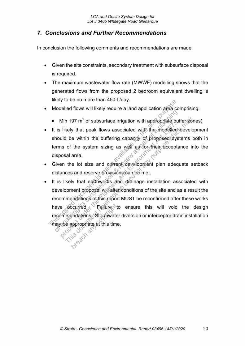
LCA and Onsite System Design for Lot 3 340b Whitegate Road Glenaroua
7. Conclusions and Further Recommendations
In conclusion the following comments and recommendations are made:
• Given the site constraints, secondary treatment with subsurface disposal
is required.
• The maximum wastewater flow rate (MWWF) modelling shows that the
generated flows from the proposed 2 bedroom equivalent dwelling is
likely to be no more than 450 L/day.
• Modelled flows will likely require a land application area comprising:
• Min 197 m2 of subsurface irrigation with appropriate buffer zones)
• It is likely that peak flows associated with the modelled development
should be within the buffering capacity of proposed systems both in
terms of the system sizing as well as for their acceptance into the
disposal area.
• Given the lot size and current development plan adequate setback
distances and reserve provisions can be met.
• It is likely that earthworks and drainage installation associated with
development proposal will alter conditions of the site and as a result the
recommendations of this report MUST be reconfirmed after these works
have occurred. Failure to ensure this will void the design
recommendations. Stormwater diversion or interceptor drain installation
may be appropriate at this time. This co
pied d
ocum
ent is
mad
e ava
ilable
for th
e sole
purpo
se
of en
ablin
g its
cons
iderat
ion & re
view as
part o
f a pl
annin
g
proce
ss un
der th
e Plan
ning a
nd Env
ironm
ent A
ct 19
87.
This do
cumen
t mus
t not
be us
ed fo
r any
purpo
se w
hich m
ay
breac
h any
copy
right.
© Strata - Geoscience and Environmental. Report 03496 14/01/2020 20
LCA and Onsite System Design for Lot 3 340b Whitegate Road Glenaroua
• If the prescriptions of this report are followed the likely human and environmental health risks associated with effluent disposal over the site is low.
S Nielsen MEngSc CPSS Director Strata Geoscience and Environmental Pty Ltd P: 0413545358 E: [email protected] W: www.strataconsulting.com.au
This co
pied d
ocum
ent is
mad
e ava
ilable
for th
e sole
purpo
se
of en
ablin
g its
cons
iderat
ion & re
view as
part o
f a pl
annin
g
proce
ss un
der th
e Plan
ning a
nd Env
ironm
ent A
ct 19
87.
This do
cumen
t mus
t not
be us
ed fo
r any
purpo
se w
hich m
ay
breac
h any
copy
right.
© Strata - Geoscience and Environmental. Report 03496 14/01/2020 21

LCA and Onsite System Design for Lot 3 340b Whitegate Road Glenaroua
8. References
• AS1726-1993- Geotechnical Site Investigations
• AS 1547-2012 Onsite Wastewater Disposal
• Bureau of Meteorology Website- Monthly Climate Statistics
• EPA (2016) Vic Code of Practice for Onsite Wastewater Management
• MAV & DSE 2006 (as amended) Model LCA Report
• VLCAF (2013) Victorian Land Capability Assessment Framework –
Calculation of Water and Nutrient Balances
• Isbell (2002) Australian Soil Classification (Revised Edn) CSIRO
Publishing
This co
pied d
ocum
ent is
mad
e ava
ilable
for th
e sole
purpo
se
of en
ablin
g its
cons
iderat
ion & re
view as
part o
f a pl
annin
g
proce
ss un
der th
e Plan
ning a
nd Env
ironm
ent A
ct 19
87.
This do
cumen
t mus
t not
be us
ed fo
r any
purpo
se w
hich m
ay
breac
h any
copy
right.
© Strata - Geoscience and Environmental. Report 03496 14/01/2020 22

LCA and Onsite System Design for Lot 3 340b Whitegate Road Glenaroua
Appendix 1 Indicative Borelog
This co
pied d
ocum
ent is
mad
e ava
ilable
for th
e sole
purpo
se
of en
ablin
g its
cons
iderat
ion & re
view as
part o
f a pl
annin
g
proce
ss un
der th
e Plan
ning a
nd Env
ironm
ent A
ct 19
87.
This do
cumen
t mus
t not
be us
ed fo
r any
purpo
se w
hich m
ay
breac
h any
copy
right.
© Strata - Geoscience and Environmental. Report 03496 14/01/2020 23

LCA and Onsite System Design for Lot 3 340b Whitegate Road Glenaroua
Appendix 2 Nutrient and Water Balance Calculations (after VLCAF 2013)
This co
pied d
ocum
ent is
mad
e ava
ilable
for th
e sole
purpo
se
of en
ablin
g its
cons
iderat
ion & re
view as
part o
f a pl
annin
g
proce
ss un
der th
e Plan
ning a
nd Env
ironm
ent A
ct 19
87.
This do
cumen
t mus
t not
be us
ed fo
r any
purpo
se w
hich m
ay
breac
h any
copy
right.
© Strata - Geoscience and Environmental. Report 03496 14/01/2020 24

LCA and Onsite System Design for Lot 3 340b Whitegate Road Glenaroua
Appendix 3 Wastewater System Design
This co
pied d
ocum
ent is
mad
e ava
ilable
for th
e sole
purpo
se
of en
ablin
g its
cons
iderat
ion & re
view as
part o
f a pl
annin
g
proce
ss un
der th
e Plan
ning a
nd Env
ironm
ent A
ct 19
87.
This do
cumen
t mus
t not
be us
ed fo
r any
purpo
se w
hich m
ay
breac
h any
copy
right.
© Strata - Geoscience and Environmental. Report 03496 14/01/2020 25

LCA and Onsite System Design for Lot 3 340b Whitegate Road Glenaroua
Irrigation Design
This co
pied d
ocum
ent is
mad
e ava
ilable
for th
e sole
purpo
se
of en
ablin
g its
cons
iderat
ion & re
view as
part o
f a pl
annin
g
proce
ss un
der th
e Plan
ning a
nd Env
ironm
ent A
ct 19
87.
This do
cumen
t mus
t not
be us
ed fo
r any
purpo
se w
hich m
ay
breac
h any
copy
right.
Figure 1 Irrigation cross section showing major delivery/flush lines and irrigation lines.
Figure 2 Irrigation Plan View
© Strata - Geoscience and Environmental. Report 03496 14/01/2020 26

LCA and Onsite System Design for Lot 3 340b Whitegate Road Glenaroua
Land Application Area Design and Construction Notes
1. Delivery/flush line diameter = 25 -30 mm 2. Irrigation line diameter = 12-16mm 3. Irrigation line spacing (A) =300 mm for Sands, Sandy Loams and Loams to 600mm for
Clay Loams, Light Clays and Heavy Clays (see the wastewater flow modelling section of this report for soil classification).
4. Dripper/Sprinkler spacing (B) as per manufacturers specifications. 5. A vacuum breaker should be installed at the highest point of the irrigation area (or in
the case of multiple irrigation lots at each lot). This breaker should be protected and marked).
6. A flush line should be installed at the lowest point of the irrigation area incorporating a return valve for back flushing of the system back into the treatment chamber.
7. All lateral lines MUST be installed parallel to the contours of the land. All minimum setbacks MUST be adhered to.
8. An inline filter must be inserted into the delivery line. 9. The first 100mm of the natural soil below the ground surface should be mechanically
tilled to aid line installation and soil permeability 10. Gypsum should be incorporated at the rate of 1kg/5m2 in dispersive soils. 11. Imported topsoil (not clay) should be applied as shown above. 12. Selected vegetation should be planted at a density of approx. 1 plant per 4m2.
Recommendation regarding suitable species is made in this report. 13. Irrigation areas greater than 400 m2 should be split into 100 m2 cells with effluent flows
switched between irrigation lots with an automatic valve system. 14. Where practical a 50% reserve area should be identified on the site to allow movement
of the irrigation area if required. 15. In areas of moderate to steep slopes (>10%) then upslope cut off drainage should be
installed to minimise shallow ground water recharge of the irrigation area from upslope. 16. All livestock and Vehicles MUST be excluded from irrigation area.
This co
pied d
ocum
ent is
mad
e ava
ilable
for th
e sole
purpo
se
of en
ablin
g its
cons
iderat
ion & re
view as
part o
f a pl
annin
g
proce
ss un
der th
e Plan
ning a
nd Env
ironm
ent A
ct 19
87.
This do
cumen
t mus
t not
be us
ed fo
r any
purpo
se w
hich m
ay
breac
h any
copy
right.
© Strata - Geoscience and Environmental. Report 03496 14/01/2020 27

LCA and Onsite System Design for Lot 3 340b Whitegate Road Glenaroua
Appendix 4 Extract from EPAV 2016
This co
pied d
ocum
ent is
mad
e ava
ilable
for th
e sole
purpo
se
of en
ablin
g its
cons
iderat
ion & re
view as
part o
f a pl
annin
g
proce
ss un
der th
e Plan
ning a
nd Env
ironm
ent A
ct 19
87.
This do
cumen
t mus
t not
be us
ed fo
r any
purpo
se w
hich m
ay
breac
h any
copy
right.
© Strata - Geoscience and Environmental. Report 03496 14/01/2020 28
LCA and Onsite System Design for Lot 3 340b Whitegate Road Glenaroua
This co
pied d
ocum
ent is
mad
e ava
ilable
for th
e sole
purpo
se
of en
ablin
g its
cons
iderat
ion & re
view as
part o
f a pl
annin
g
proce
ss un
der th
e Plan
ning a
nd Env
ironm
ent A
ct 19
87.
This do
cumen
t mus
t not
be us
ed fo
r any
purpo
se w
hich m
ay
breac
h any
copy
right.
© Strata - Geoscience and Environmental. Report 03496 14/01/2020 29

LCA and Onsite System Design for Lot 3 340b Whitegate Road Glenaroua
This co
pied d
ocum
ent is
mad
e ava
ilable
for th
e sole
purpo
se
of en
ablin
g its
cons
iderat
ion & re
view as
part o
f a pl
annin
g
proce
ss un
der th
e Plan
ning a
nd Env
ironm
ent A
ct 19
87.
This do
cumen
t mus
t not
be us
ed fo
r any
purpo
se w
hich m
ay
breac
h any
copy
right.
© Strata - Geoscience and Environmental. Report 03496 14/01/2020 30

LCA and Onsite System Design for Lot 3 340b Whitegate Road Glenaroua
Appendix 5 Permeability Test Methodology (AS1547-2012)
This co
pied d
ocum
ent is
mad
e ava
ilable
for th
e sole
purpo
se
of en
ablin
g its
cons
iderat
ion & re
view as
part o
f a pl
annin
g
proce
ss un
der th
e Plan
ning a
nd Env
ironm
ent A
ct 19
87.
This do
cumen
t mus
t not
be us
ed fo
r any
purpo
se w
hich m
ay
breac
h any
copy
right.
© Strata - Geoscience and Environmental. Report 03496 14/01/2020 31

LCA and Onsite System Design for Lot 3 340b Whitegate Road Glenaroua
This co
pied d
ocum
ent is
mad
e ava
ilable
for th
e sole
purpo
se
of en
ablin
g its
cons
iderat
ion & re
view as
part o
f a pl
annin
g
proce
ss un
der th
e Plan
ning a
nd Env
ironm
ent A
ct 19
87.
This do
cumen
t mus
t not
be us
ed fo
r any
purpo
se w
hich m
ay
breac
h any
copy
right.
© Strata - Geoscience and Environmental. Report 03496 14/01/2020 32

LCA and Onsite System Design for Lot 3 340b Whitegate Road Glenaroua
Appendix 6 Terms and Conditions Scope of WorkThese Terms and Conditions apply to any services provided to you (“the Client”) by Strata Geoscience and Environmental Pty Ltd (“Strata”). By continuing to instruct Strata to act after receiving the Terms and Conditions or by using this report and its findings for design and/or permit application processes and not objecting to any of the Terms and Conditions the Client agrees to be bound by these Terms and Conditions, and any other terms and conditions supplied by Strata from time to time at Strata’s sole and absolute discretion. The scope of the services provided to the Client by Strata is limited to the services and specified purpose agreed between Strata and the Client and set out in the correspondence to which this document is enclosed or annexed (“the Services”). Strata does not purport to advise beyond the Services.
Third Parties The Services are supplied to the Client for the sole benefit of the Client and must not be relied upon by any person or entity other than the Client. Strata is not responsible or liable to any third party. All parties other than the Client are advised to seek their own advice before proceeding with any course of action.
Provision of Information The Client is responsible for the provision of all legal, survey and other particulars concerning the site on which Strata is providing the Services, including particulars of existing structures and services and features for the site and for adjoining sites and structures. The Client is also responsible for the provision of specialised services not provided by Strata. If Strata obtains these particulars or specialised services on the instruction of the Client, Strata does so as agent of the Client and at the Client's expense. Strata is not obliged to confirm the accuracy and completeness of information supplied by the Client or any third party service provider. The Client is responsible for the accuracy and completeness of all particulars or services provided by the Client or obtained on the Client’s behalf. Strata is not liable, and accepts no responsibility, for any claim, demand, charge, loss, damage, injury or expense whatsoever suffered by the Client or any other person or entity resulting from the failure of the Client or third party to provide accurate and complete information. In the event additional information becomes available to the Client, the Client must inform Strata in writing of that information as soon as possible. Further advice will be provided at the Client’s cost. Any report is prepared on the assumption that the instructions and information supplied to Strata has been provided in good faith and is all of the information relevant to the provision of the Services by Strata. Strata is not liable, and accepts no responsibility, for any claim, demand, charge, loss, damage, injury or expense whatsoever if Strata has been supplied with insufficient, incorrect, incomplete, false or misleading information.
Integrity While all reasonable care is taken reporting to the Client, Strata does not warrant that the information contained in any report is free from errors or omissions. Strata is not liable, and accepts no responsibility, for any claim, demand, charge, loss, damage, injury or expense whatsoever resulting from errors in a report. Any report should be read in its entirety, inclusive of any summary and annexures.. Strata does not accept any responsibility where part of any report is relied upon without reference to the full report. Latter versions of any report invalidate any recommendations, assumptions, or designs contained in former reports. Strata is not liable, and accepts no responsibility, for any claim, demand, charge, loss, damage, injury or expense whatsoever based upon the use of older versions of any report.
Project Specific Criteria Any report provided by Strata will be prepared on the basis of unique project development plans which apply only to the site that is being investigated. Reports provided by Strata do not apply to any project other than that originally specified by the Client to Strata. The Report must not be used or relied upon if any changes to the project are made. The Client should engage Strata to further advise on the effect of any change to the project. Further advice will be provided at the Client’s cost. Strata is not liable, and accepts no responsibility, for any claim, demand, charge, loss, damage, injury or expense whatsoever where any change to the project is made without obtaining a further written report from Strata. Changes to the project may include, but are not limited to, changes to the investigated site or neighbouring sites, for instance, variation of the location of proposed building envelopes/footprints, changes to building design which may impact upon sewage treatment plant system design, specification and performance.
Interpretation
Strata is not responsible for the interpretation of site data or report findings by other parties, including parties involved in the design and construction process. The Client must seek advice from Strata about the interpretation of the site data or report.
Design/Report Recommendations
Where sewage treatment plant and/or application system designs are provided by Strata, reasonable effort will be made to minimise environmental, public health and commercial risks associated with the disposal of effluent within site boundaries with respect to relevant Australian guidelines and industry best practise at the time of investigation. Strata is not liable, and accepts no responsibility, for any claim, demand, charge, loss, damage, injury or expense whatsoever resulting from:
(i) changes to either the project or site conditions that affect the onsite wastewater land application system’s ability to safely dispose of modelled wastewater flows; or
(ii) changes to original use of site infrastructure or changes from original modelled loadings as a result of change of use or incorrect loading information supplied by the client: or
(iii) seepage, pollution or contamination or the cost of removing, nullifying or clearing up seepage, polluting or contaminating substances; or
(iv) poor system performance where septic tanks have not been de-sludged at maximum intervals of 3 years or sewage treatment plants have not been serviced in compliance with the manufacturers recommendations; or
(v) system /component failure of any recommended system/component; or
This co
pied d
ocum
ent is
mad
e ava
ilable
for th
e sole
purpo
se
of en
ablin
g its
cons
iderat
ion & re
view as
part o
f a pl
annin
g
proce
ss un
der th
e Plan
ning a
nd Env
ironm
ent A
ct 19
87.
This do
cumen
t mus
t not
be us
ed fo
r any
purpo
se w
hich m
ay
breac
h any
copy
right.
© Strata - Geoscience and Environmental. Report 03496 14/01/2020 33

LCA and Onsite System Design for Lot 3 340b Whitegate Road Glenaroua
(vi) poor contractor construction/installation practice; or (vii) Inferior product/component selection by installing contractor ; or (viii) any treatment plant , treatment plant component or land application area breakdown of any kind; or (ix) failure of the client to commission both interim and final inspections by the designer throughout the system
construction; or (x) the selection of inappropriate plants for irrigation areas or any increased cost associated with upkeep of
recommended plants or their replacement; or (xi) damage to any infrastructure by seepage/effluent including but not limited to foundations, walls, driveways
and pavements; or (xii) land instability, soil erosion or dispersion caused by seepage/effluent or the installation of sewage plant
infrastructure; or (xiii) Excavation difficulties given hard rock, watertables, collapsing soils or other difficult conditions; or (xiv) Dammages to underground services via excavation or system installation; or (xv) design changes requested by the Permit Authority;or (xvi) time delays associated with any of the above, or to strata or any of its representatives being able to mobilise
to site for any reason.
Furthermore Strata does not guarantee septic trench, bed or mound design life beyond 2 years from installation,. Strata does not warrant EPA sand filter designs.
Strata does not consider site contamination, unless the Client specifically instructs Strata to consider the site contamination in writing. If a request is made by the Client to consider site contamination, Strata will provide additional terms and conditions that will apply to the engagement.
Copyright and Use of Documents Copyright in all drawings, reports, specifications, calculations and other documents provided by Strata or its employees in connection with the Services remain vested in Strata. The Client has a licence to use the documents for the purpose of completing the project. However, the Client must not otherwise use the documents, make copies of the documents or amend the documents unless express approval in writing is given in advance by Strata. The Client must not publish or allow to be published, in whole or in part, any document provided by Strata or the name or professional affiliations of Strata, without first obtaining the written consent of Strata as to the form and context in which it is to appear.
If, during the course of providing the Services, Strata develops, discovers or first reduces to practice a concept, product or process which is capable of being patented then such concept, product or process is and remains the property of Strata and:
(i) the Client must not use, infringe or otherwise appropriate the same other than for the purpose of the project without first obtaining the written consent of Strata; and
(ii) the Client is entitled to a royalty free licence to use the same during the life of the works comprising the project.
Digital Copies of ReportIf any report is provided to the Client in an electronic copy except directly from Strata, the Client should verify the report contents with Strata to ensure they have not been altered in any way from the original provide by Strata.
This co
pied d
ocum
ent is
mad
e ava
ilable
for th
e sole
purpo
se
of en
ablin
g its
cons
iderat
ion & re
view as
part o
f a pl
annin
g
proce
ss un
der th
e Plan
ning a
nd Env
ironm
ent A
ct 19
87.
This do
cumen
t mus
t not
be us
ed fo
r any
purpo
se w
hich m
ay
breac
h any
copy
right.
© Strata - Geoscience and Environmental. Report 03496 14/01/2020 34

This co
pied d
ocum
ent is
mad
e ava
ilable
for th
e sole
purpo
se
of en
ablin
g its
cons
iderat
ion & re
view as
part o
f a pl
annin
g
proce
ss un
der th
e Plan
ning a
nd Env
ironm
ent A
ct 19
87.
This do
cumen
t mus
t not
be us
ed fo
r any
purpo
se w
hich m
ay
breac
h any
copy
right.
Bushfire Attack Level Rating for
Lot 3 340B Whitegate Road Glenaroua
May 2020
Important Notes:
This co
pied d
ocum
ent is
mad
e ava
ilable
for th
e sole
purpo
se
of en
ablin
g its
cons
iderat
ion & re
view as
part o
f a pl
annin
g
proce
ss un
der th
e Plan
ning a
nd Env
ironm
ent A
ct 19
87.
This do
cumen
t mus
t not
be us
ed fo
r any
purpo
se w
hich m
ay
breac
h any
copy
right.
The author, Strata Geoscience and Environmental, gives permission for this report to
be copied and distributed to interested parties only if it is reproduced in colour and in
full including all appendicies. No responsibility is taken for the contents and
recommendations of this report if it is not reproduced as requested.
Strata Geoscience and Environmental reserves the right to submit this report the
relevant regulatory agencies where it has a responsibility to do so.

1. Introduction
Strata Geoscience and Environmental was commissioned to perform a Bushfire Attached Level (BAL) assessment for:
Client and Site Details Client Name Simon Luthi
Site Address Lot 3 340B Whitegate Road Glenaroua
Proposed Development New dwelling
This co
pied d
ocum
ent is
mad
e ava
ilable
for th
e sole
purpo
se
of en
ablin
g its
cons
iderat
ion & re
view as
part o
f a pl
annin
g
proce
ss un
der th
e Plan
ning a
nd Env
ironm
ent A
ct 19
87.
This do
cumen
t mus
t not
be us
ed fo
r any
purpo
se w
hich m
ay
breac
h any
copy
right.
The investigation was conducted with reference to Australian Standard AS 3959-2009
2. Results
The results of the assessment are as follows:
FDI 100
Vegetation Type GROUP B –
Woodland
Distance to Vegetation Type (m) 60 (APPROX)
Effective Slope (°) DOWNSLOPE
BAL 19*
* MUST BE RECONFIMED WHEN DEVELOPMENT PLANS ARE FINALISED AND DEVEGETATION/SITE LANDSCAPING HAS BEEN COMPLETED. FAILURE TO ENSURE THIS WILL VOID THE ABOVE RATING.

This co
pied d
ocum
ent is
mad
e ava
ilable
for th
e sole
purpo
se
of en
ablin
g its
cons
iderat
ion & re
view as
part o
f a pl
annin
g
proce
ss un
der th
e Plan
ning a
nd Env
ironm
ent A
ct 19
87.
This do
cumen
t mus
t not
be us
ed fo
r any
purpo
se w
hich m
ay
breac
h any
copy
right.
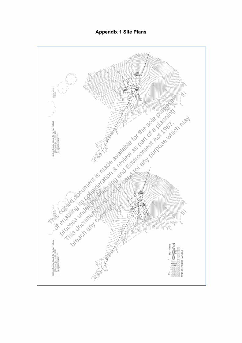
This co
pied d
ocum
ent is
mad
e ava
ilable
for th
e sole
purpo
se
of en
ablin
g its
cons
iderat
ion & re
view as
part o
f a pl
annin
g
proce
ss un
der th
e Plan
ning a
nd Env
ironm
ent A
ct 19
87.
This do
cumen
t mus
t not
be us
ed fo
r any
purpo
se w
hich m
ay
breac
h any
copy
right.
8700
20°
5900
35°
8530
7920
Split
Hou
se R
eloc
atio
n Op
tion
3 -S
ite P
lan
Scal
e 1:
500
@A3
Sp
lit H
ouse
Rel
ocat
ion
Optio
n 4
-Site
Pla
n Sc
ale
1:50
0@A3
-
500m
m e
xcav
atio
n fro
m N
GL 2
45.8
00
-50
0mm
exc
avat
ion
from
NGL
246
.600
-
5.9
m s
etba
ck fr
om a
cces
s tra
ck
-5.
9 m
set
back
from
acc
ess
track
-
35° a
ngle
from
Tru
e No
rth
-20
° ang
le fr
om T
rue
North
NGL
243.9
50
NORT
H TR
UE
245.7
00
NGL
ENTR
Y NG
L 24
4.450
FF
L 246
.220
LIVIN
G'S W
ING
FFL 2
45.77
0 24
6.600
NG
L 24
5.800
NG
L 24
3.950
NG
L BE
DROO
MS' W
ING
TERR
ACE
FFL 2
46.52
0 FF
L 246
.220
NGL
244.1
00
ENTR
Y LIV
ING'
S WIN
G TR
UE
FFL 2
44.97
0 NG
L 24
4.800
APPROX. 2800
NORT
H TE
RRAC
E NG
L 24
5.800
BE
DROO
MS' W
ING
FFL 2
45.42
0 FF
L 245
.720
GI N
AIL
PLCD
NG
L 24
4.400
NGL
244.4
00
APPROX. 3300
NGL
245.7
50
NGL
245.3
50
GI N
AIL
PLCD
NGL
244.5
50
NGL
500mm excavation
80
FFL B
edro
om
150 gap
270 SIP
TYPI
CAL
SET-
DOW
N DE
TAIL
Sca
le 1
:50@
A3
Appendix 1 Site Plans

Appendix 2 Extracts from AS3935-2009
This co
pied d
ocum
ent is
mad
e ava
ilable
for th
e sole
purpo
se
of en
ablin
g its
cons
iderat
ion & re
view as
part o
f a pl
annin
g
proce
ss un
der th
e Plan
ning a
nd Env
ironm
ent A
ct 19
87.
This do
cumen
t mus
t not
be us
ed fo
r any
purpo
se w
hich m
ay
breac
h any
copy
right.

This co
pied d
ocum
ent is
mad
e ava
ilable
for th
e sole
purpo
se
of en
ablin
g its
cons
iderat
ion & re
view as
part o
f a pl
annin
g
proce
ss un
der th
e Plan
ning a
nd Env
ironm
ent A
ct 19
87.
This do
cumen
t mus
t not
be us
ed fo
r any
purpo
se w
hich m
ay
breac
h any
copy
right.
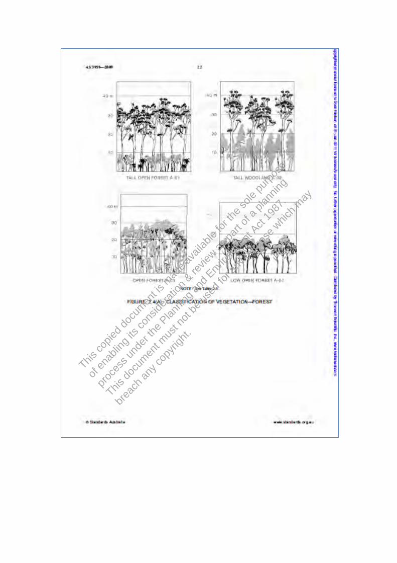
This co
pied d
ocum
ent is
mad
e ava
ilable
for th
e sole
purpo
se
of en
ablin
g its
cons
iderat
ion & re
view as
part o
f a pl
annin
g
proce
ss un
der th
e Plan
ning a
nd Env
ironm
ent A
ct 19
87.
This do
cumen
t mus
t not
be us
ed fo
r any
purpo
se w
hich m
ay
breac
h any
copy
right.

This co
pied d
ocum
ent is
mad
e ava
ilable
for th
e sole
purpo
se
of en
ablin
g its
cons
iderat
ion & re
view as
part o
f a pl
annin
g
proce
ss un
der th
e Plan
ning a
nd Env
ironm
ent A
ct 19
87.
This do
cumen
t mus
t not
be us
ed fo
r any
purpo
se w
hich m
ay
breac
h any
copy
right.

This co
pied d
ocum
ent is
mad
e ava
ilable
for th
e sole
purpo
se
of en
ablin
g its
cons
iderat
ion & re
view as
part o
f a pl
annin
g
proce
ss un
der th
e Plan
ning a
nd Env
ironm
ent A
ct 19
87.
This do
cumen
t mus
t not
be us
ed fo
r any
purpo
se w
hich m
ay
breac
h any
copy
right.

This co
pied d
ocum
ent is
mad
e ava
ilable
for th
e sole
purpo
se
of en
ablin
g its
cons
iderat
ion & re
view as
part o
f a pl
annin
g
proce
ss un
der th
e Plan
ning a
nd Env
ironm
ent A
ct 19
87.
This do
cumen
t mus
t not
be us
ed fo
r any
purpo
se w
hich m
ay
breac
h any
copy
right.

This co
pied d
ocum
ent is
mad
e ava
ilable
for th
e sole
purpo
se
of en
ablin
g its
cons
iderat
ion & re
view as
part o
f a pl
annin
g
proce
ss un
der th
e Plan
ning a
nd Env
ironm
ent A
ct 19
87.
This do
cumen
t mus
t not
be us
ed fo
r any
purpo
se w
hich m
ay
breac
h any
copy
right.

This co
pied d
ocum
ent is
mad
e ava
ilable
for th
e sole
purpo
se
of en
ablin
g its
cons
iderat
ion & re
view as
part o
f a pl
annin
g
proce
ss un
der th
e Plan
ning a
nd Env
ironm
ent A
ct 19
87.
This do
cumen
t mus
t not
be us
ed fo
r any
purpo
se w
hich m
ay
breac
h any
copy
right.

This co
pied d
ocum
ent is
mad
e ava
ilable
for th
e sole
purpo
se
of en
ablin
g its
cons
iderat
ion & re
view as
part o
f a pl
annin
g
proce
ss un
der th
e Plan
ning a
nd Env
ironm
ent A
ct 19
87.
This do
cumen
t mus
t not
be us
ed fo
r any
purpo
se w
hich m
ay
breac
h any
copy
right.

This co
pied d
ocum
ent is
mad
e ava
ilable
for th
e sole
purpo
se
of en
ablin
g its
cons
iderat
ion & re
view as
part o
f a pl
annin
g
proce
ss un
der th
e Plan
ning a
nd Env
ironm
ent A
ct 19
87.
This do
cumen
t mus
t not
be us
ed fo
r any
purpo
se w
hich m
ay
breac
h any
copy
right.

Appendix 2 Terms and Conditions
Scope of Work These Terms and Conditions apply to any services provided to you (“the Client”) by Strata Geoscience and Environmental Pty Ltd (“Strata”). By continuing to instruct Strata to act after receiving the Terms and Conditions or by using this report and its findings for design and/or permit application processes and not objecting to any of the Terms and Conditions the Client agrees to be bound by these Terms and Conditions, and any other terms and conditions supplied by Strata from time to time at Strata’s sole and absolute discretion. The scope of the services provided to the Client by Strata is limited to the services and specified purpose agreed between Strata and the Client and set out in the correspondence to which this document is enclosed or annexed (“the Services”). Strata does not purport to advise beyond the Services.
This co
pied d
ocum
ent is
mad
e ava
ilable
for th
e sole
purpo
se
of en
ablin
g its
cons
iderat
ion & re
view as
part o
f a pl
annin
g
proce
ss un
der th
e Plan
ning a
nd Env
ironm
ent A
ct 19
87.
This do
cumen
t mus
t not
be us
ed fo
r any
purpo
se w
hich m
ay
breac
h any
copy
right.
Third Parties The Services are supplied to the Client for the sole benefit of the Client and must not be relied upon by any person or entity other than the Client. Strata is not responsible or liable to any third party. All parties other than the Client are advised to seek their own advice before proceeding with any course of action.
Provision of Information The Client is responsible for the provision of all legal, survey and other particulars concerning the site on which Strata is providing the Services, including particulars of existing structures and services and features for the site and for adjoining sites and structures. The Client is also responsible for the provision of specialised services not provided by Strata. If Strata obtains these particulars or specialised services on the instruction of the Client, Strata does so as agent of the Client and at the Client's expense. Strata is not obliged to confirm the accuracy and completeness of information supplied by the Client or any third party service provider. The Client is responsible for the accuracy and completeness of all particulars or services provided by the Client or obtained on the Client’s behalf. Strata is not liable, and accepts no responsibility, for any claim, demand, charge, loss, damage, injury or expense whatsoever suffered by the Client or any other person or entity resulting from the failure of the Client or third party to provide accurate and complete information. In the event additional information becomes available to the Client, the Client must inform Strata in writing of that information as soon as possible. Further advice will be provided at the Client’s cost. Any report is prepared on the assumption that the instructions and information supplied to Strata has been provided in good faith and is all of the information relevant to the provision of the Services by Strata. Strata is not liable, and accepts no responsibility, for any claim, demand, charge, loss, damage, injury or expense whatsoever if Strata has been supplied with insufficient, incorrect, incomplete, false or misleading information.
Integrity Any report provided by Strata presents the findings of the site assessment. While all reasonable care is taken when conducting site investigations and reporting to the Client, Strata does not warrant that the information contained in any report is free from errors or omissions. Strata is not liable, and accepts no responsibility, for any claim, demand, charge, loss, damage, injury or expense whatsoever resulting from errors in a report. Any report should be read in its entirety, inclusive of any summary and annexures. Strata does not accept any responsibility where part of any report is relied upon without reference to the full report.
Project Specific Criteria Any report provided by Strata will be prepared on the basis of unique project development plans which apply only to the site that is being investigated. Reports provided by Strata do not apply to any project other than that originally specified by the Client to Strata. The Report must not be used or relied upon if any changes to the project are made. The Client should engage Strata to further advise on the effect of any change to the project. Further advice will be provided at the Client’s cost. Strata is not liable, and accepts no responsibility, for any claim, demand, charge, loss, damage, injury or expense whatsoever where any change to the project is made without obtaining a further written report from Strata. Changes to the project may include, but are not limited to, changes to the investigated site or neighbouring sites, for instance, variation of the location of proposed building envelopes/footprints, changes to building design which may impact upon building settlement or slope stability, or changes to earthworks, including removal (site cutting) or deposition of sediments or rock from the site.
Copyright and Use of Documents Copyright in all drawings, reports, specifications, calculations and other documents provided by Strata or its employees in connection with the Services remain vested in Strata. The Client has a licence to use the documents for the purpose of completing the project. However, the Client must not otherwise use the documents, make copies of the documents or amend the documents unless express approval in writing is given in advance by Strata. The Client must not publish or allow to be published, in whole or in part, any document provided by Strata or the name or professional affiliations of Strata, without first obtaining the written consent of Strata as to the form and context in which it is to appear.
If, during the course of providing the Services, Strata develops, discovers or first reduces to practice a concept, product or process which is capable of being patented then such concept, product or process is and remains the property of Strata and:
(i) the Client must not use, infringe or otherwise appropriate the same other than for the purpose of the project without first obtaining the written consent of Strata; and
(ii) the Client is entitled to a royalty free licence to use the same during the life of the works comprising the project.
Digital Copies of Report If any report is provided to the Client in an electronic copy except directly from Strata, the Client should verify the report contents with Strata to ensure they have not been altered or varied from the report provided by Strata.


![U Sole Rn Israeli Ionflict C W[1]](https://img.pdfslide.us/doc/110x75/54908e2fb47959072a8b4d50/u-sole-rn-israeli-ionflict-c-w1.jpg)