Embed Size (px)
Citation preview
Geotechnical Study Area G13 Overstrand, north Norfolk, UK
1
GEOTECHNICAL STUDY AREA G13
OVERSTRAND, NORTH NORFOLK, UK
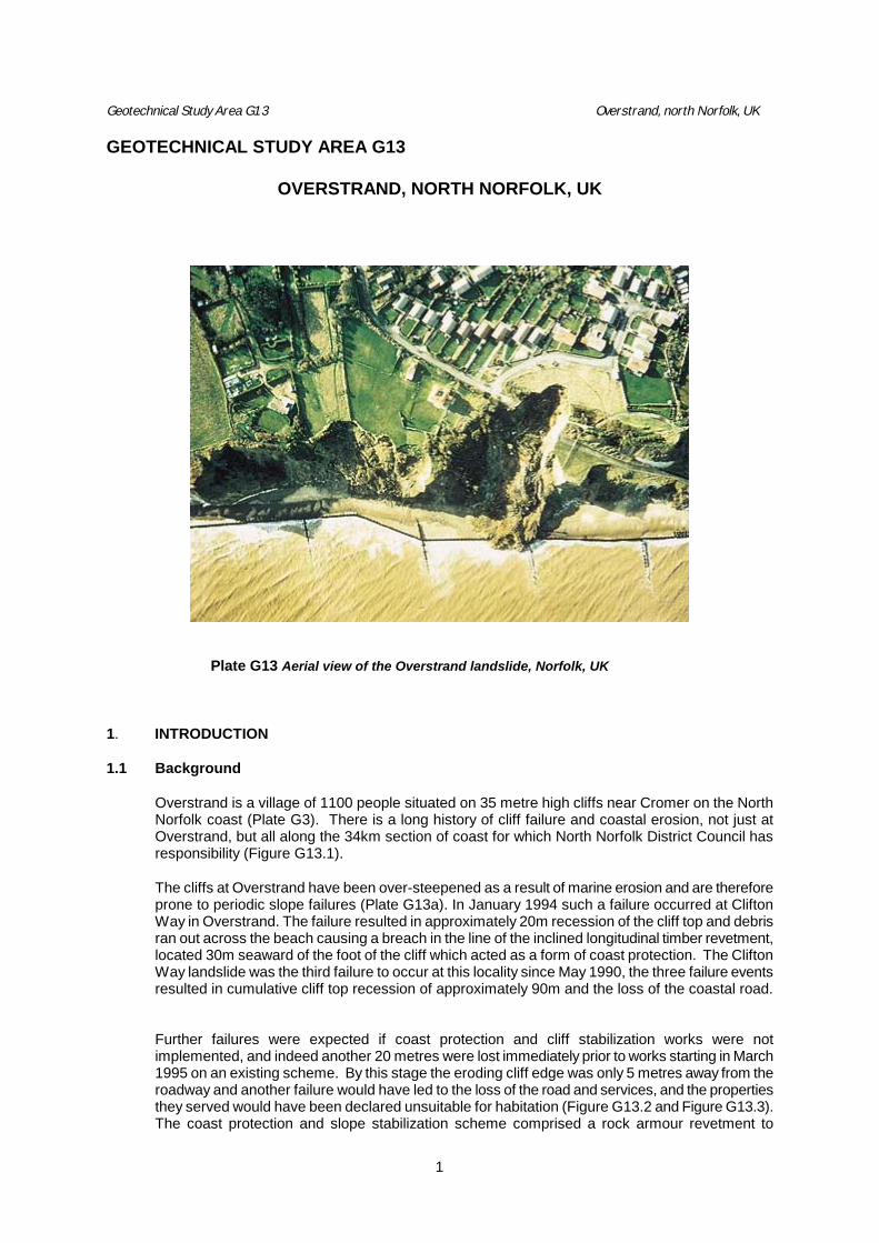
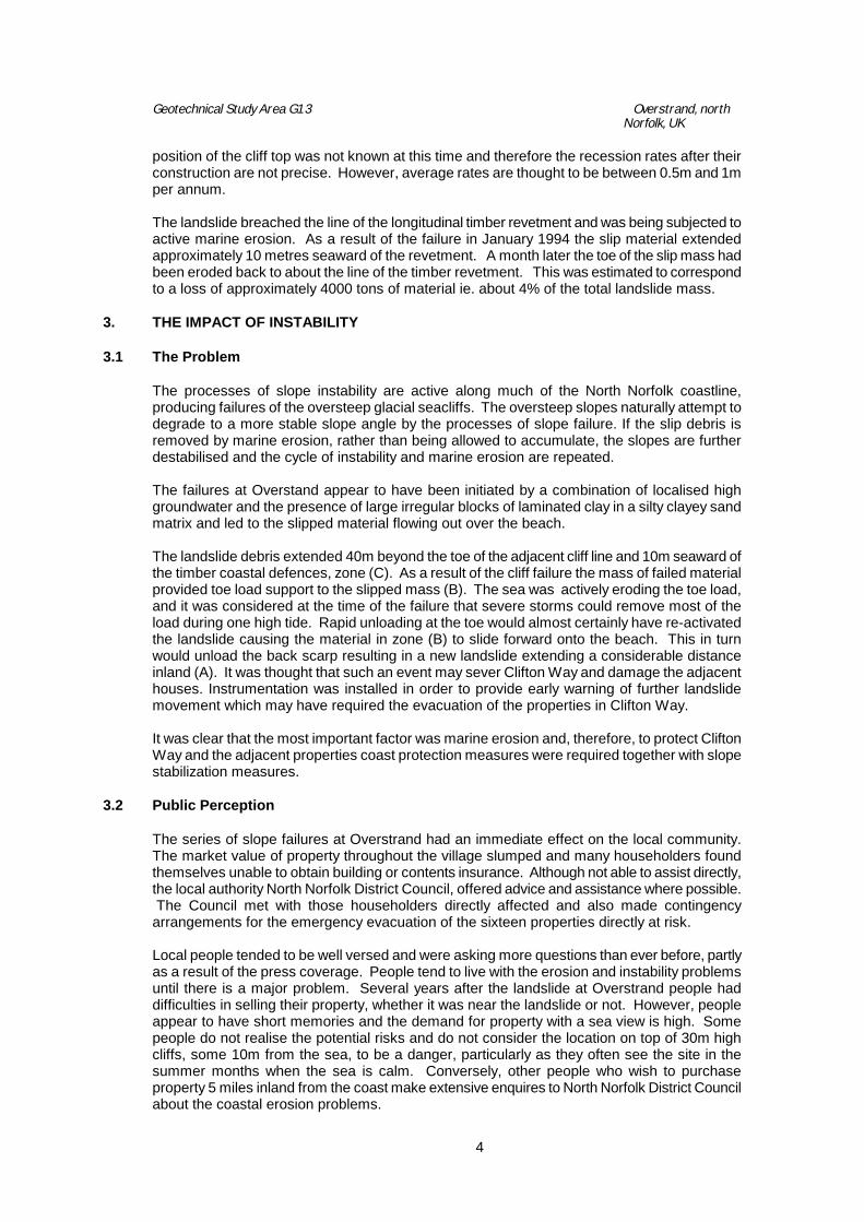
Plate G13 Aerial view of the Overstrand landslide, Norfolk, UK 1. INTRODUCTION 1.1 Background
Overstrand is a village of 1100 people situated on 35 metre high cliffs near Cromer on the North Norfolk coast (Plate G3). There is a long history of cliff failure and coastal erosion, not just at Overstrand, but all along the 34km section of coast for which North Norfolk District Council has responsibility (Figure G13.1). The cliffs at Overstrand have been over-steepened as a result of marine erosion and are therefore prone to periodic slope failures (Plate G13a). In January 1994 such a failure occurred at Clifton Way in Overstrand. The failure resulted in approximately 20m recession of the cliff top and debris ran out across the beach causing a breach in the line of the inclined longitudinal timber revetment, located 30m seaward of the foot of the cliff which acted as a form of coast protection. The Clifton Way landslide was the third failure to occur at this locality since May 1990, the three failure events resulted in cumulative cliff top recession of approximately 90m and the loss of the coastal road.
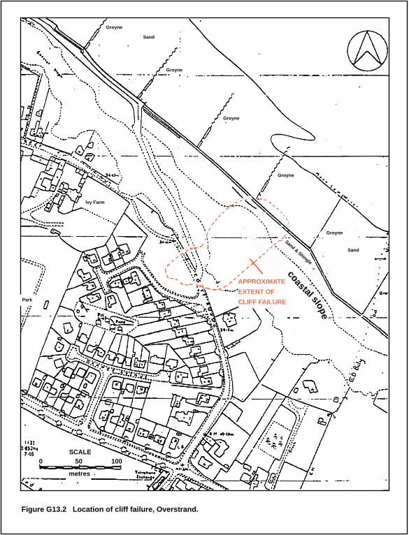
Further failures were expected if coast protection and cliff stabilization works were not implemented, and indeed another 20 metres were lost immediately prior to works starting in March 1995 on an existing scheme. By this stage the eroding cliff edge was only 5 metres away from the roadway and another failure would have led to the loss of the road and services, and the properties they served would have been declared unsuitable for habitation (Figure G13.2 and Figure G13.3). The coast protection and slope stabilization scheme comprised a rock armour revetment to
Geotechnical Study Area G13 Overstrand, north Norfolk, UK
2
prevent marine erosion at the toe of the landslide and various drainage and slope reprofiling measures within the landslide debris. Prior to construction work, emergency works were implemented to reduce the potential for further failures in the interim, and ground movement monitoring was installed in order to provide an early warning system for the cliff top properties. The extent of the scheme was restricted to the area of the existing landslide and the toe protection works extending no further from the cliffline than the toe of the slip mass. Earthworks were kept to a minimum so that the scheme did not significantly change either the morphology of the coastal slopes or the near shore sediment transport regime of the area which is classified as a Site of Special Scientific Interest.
2. THE STUDY AREA 2.1 Topography and Site Description
The coastal cliffs at Overstrand rise steeply at between 35_ and 50_ from sea-level to approximately 35m OD. Above the seacliff the ground gently rises inland to the south and the east. There is a sandy beach in front of the cliffs which covers a gently inclined foreshore, which decreases in elevation from 2-3m OD seawards at a gradient of about 1:50. The cliffs and foreshore are designated as a Site of Special Scientific Interest by virtue of their geological and geomorphological features. The special consent of English Nature was required prior to undertaking the coast protection and slope stabilization works which are otherwise specifically precluded.
2.2 Geology
The seacliffs at Overstrand are underlain by the Upper Chalk, the upper eroded surface of which is at approximately –4m OD below the current beach level. A thin bed of flints typically overlies the Chalk in this area, and also grey shelly sand, which in turn is overlain by a varied succession of shallow water deposits. These deposits largely comprise sands and gravels which are thought to be of pre-glacial Pleistocene origin. These deposits outcrop at the base of the seacliff where they are normally concealed by beach deposits and talus. Overlying the shallow water deposits are glacial tills, sands and laminated clays which form the main cliff profile. A marked feature of the cliff exposures in this area, associated with the ‘Cromer Ridge’, is the highly contorted and rapidly varying nature of these deposits and the presence of huge chalk erratics (visible in the cliff immediately to the west of the slip). This variation in lithology within the glacial deposits is evident in the scarp slopes surrounding the failure. In the west face of the failed cliff, extensive beds of sands and very stiff laminated clays, standing nearly vertical are present whilst in the south and west faces softer grey clays with silt laminations are present. The deep indentation of the slip into the cliffline and its slightly oblique orientation of the cliffline lend support to the view that the occurrence of the slope failure is strongly influenced by local geology and groundwater conditions in the area.
2.3 Drainage and Groundwater The general topography of the area is such that the area of the landslide appears to be a local low spot along the cliffline and as such it would be anticipated that groundwater flows would tend to concentrate in this area.
Geotechnical Study Area G13 Overstrand, north Norfolk, UK
3
The 1885 1:10560 scale Ordnance Survey map of the area shows the existence of clay pits and ponds in the immediate vicinity of the current cliff top. Anecdotal evidence from local residents suggests that there are springs which emerge from the cliffs on the eastern side of the landslide. The groundwater regime of the area is complex reflecting the highly variable nature of the soil deposits. A series of gravity wells were sunk into the sands, gravels and chalk beneath the glacial deposits to lower groundwater levels. The groundwater levels observed varied between 2m and 4m above OD (January 1994). The water levels within the wells were found to vary quite rapidly in response to rainfall events. In addition, perched water tables are known to be present within the glacial till deposits. The precise details of drainage network in the area for the highways and housing are not known, although it understood that some of the older properties are served by soakaways, and what is believed to be the remains of a soakaway was visible on the surface of the landslide mass. The landslide severed a number of pipes in the area including the line of the main sewer, resulting in discharge of water into the landslide mass. The sewer, a 225mm diameter pipe, served 60 houses and a school. The sewer was diverted around the landslide by over pumping between two manholes either side of the landslide and measures were taken to divert the flow from the drainage pipes.
2.4 Geomorphology and Landslides
The moderately high glacial cliffs which dominate this length of coastline are prone to the formation of significant rotational landslides and mudslides. The profile of the coastline south east of Cromer causes longshore currents to become stronger though they are still predominantly offshore. Whereas this stretch of coastline can be exposed to persistent easterly waves, longshore energy is low and the potential for sediment transport is variable; ie. north westerly and south easterly with a net south easterly drift. Beach monitoring shows that the beach is steepening and because it is narrow the average annual cliff recession of 1.5 –2m is commonplace making this a major source of sediment. Processes of slope instability are active along much of this coastline, producing failures of the oversteep glacial seacliffs. The oversteep slopes naturally attempt to degrade to a more stable slope angle by the processes of slope failure. Such failures involve the downslope movement of material, and effectively result in the forward movement of the toe of the slope and the regression of the crest to produce an overall shallower slope angle. If the slip debris is allowed to accumulate a more stable geometry is eventually achieved. Coastal soil slopes, where the toe is inadequately protected from marine erosion, fail to achieve this long term shallower slope angle as material is continually being removed from the toe. This causes the slope to be subjected to an ongoing cycle of slope failure and erosion resulting in the landward migration of the crest of the slope. At the same time, the back scar of the original failure is exposed to weathering and deterioration, leading to a succession of smaller failures, which tends to slow the overall process, but in the end is not sufficient to produce a stable slope. As a result of this cyclical process, failures at any one point tend to be several years apart.
The cliff line along this section of coast has been progressively receding as a result of marine erosion and associated landsliding. Average rates of cliff top recession have been estimated using historic survey maps of the area (1885, 1907,1930 and 1991). It is evident from these maps that the historic recession rates were both variable with respect to time and location. The surveys of 1885 and 1907 indicate average rates of recession of approximately 1.5 to 2m per year. Similarly from the 1907 and the 1930 surveys, the average rates of recession were about 2m per year. Between 1930 and 1991 beach protection measures were built at various times (for example 1969 and 1980), which gave partial protection to the toe of the cliffs. The accurate
Geotechnical Study Area G13 Overstrand, north Norfolk, UK
4
position of the cliff top was not known at this time and therefore the recession rates after their construction are not precise. However, average rates are thought to be between 0.5m and 1m per annum. The landslide breached the line of the longitudinal timber revetment and was being subjected to active marine erosion. As a result of the failure in January 1994 the slip material extended approximately 10 metres seaward of the revetment. A month later the toe of the slip mass had been eroded back to about the line of the timber revetment. This was estimated to correspond to a loss of approximately 4000 tons of material ie. about 4% of the total landslide mass.
3. THE IMPACT OF INSTABILITY 3.1 The Problem
The processes of slope instability are active along much of the North Norfolk coastline, producing failures of the oversteep glacial seacliffs. The oversteep slopes naturally attempt to degrade to a more stable slope angle by the processes of slope failure. If the slip debris is removed by marine erosion, rather than being allowed to accumulate, the slopes are further destabilised and the cycle of instability and marine erosion are repeated.
The failures at Overstand appear to have been initiated by a combination of localised high groundwater and the presence of large irregular blocks of laminated clay in a silty clayey sand matrix and led to the slipped material flowing out over the beach. The landslide debris extended 40m beyond the toe of the adjacent cliff line and 10m seaward of the timber coastal defences, zone (C). As a result of the cliff failure the mass of failed material provided toe load support to the slipped mass (B). The sea was actively eroding the toe load, and it was considered at the time of the failure that severe storms could remove most of the load during one high tide. Rapid unloading at the toe would almost certainly have re-activated the landslide causing the material in zone (B) to slide forward onto the beach. This in turn would unload the back scarp resulting in a new landslide extending a considerable distance inland (A). It was thought that such an event may sever Clifton Way and damage the adjacent houses. Instrumentation was installed in order to provide early warning of further landslide movement which may have required the evacuation of the properties in Clifton Way. It was clear that the most important factor was marine erosion and, therefore, to protect Clifton Way and the adjacent properties coast protection measures were required together with slope stabilization measures.
3.2 Public Perception
The series of slope failures at Overstrand had an immediate effect on the local community. The market value of property throughout the village slumped and many householders found themselves unable to obtain building or contents insurance. Although not able to assist directly, the local authority North Norfolk District Council, offered advice and assistance where possible. The Council met with those householders directly affected and also made contingency arrangements for the emergency evacuation of the sixteen properties directly at risk. Local people tended to be well versed and were asking more questions than ever before, partly as a result of the press coverage. People tend to live with the erosion and instability problems until there is a major problem. Several years after the landslide at Overstrand people had difficulties in selling their property, whether it was near the landslide or not. However, people appear to have short memories and the demand for property with a sea view is high. Some people do not realise the potential risks and do not consider the location on top of 30m high cliffs, some 10m from the sea, to be a danger, particularly as they often see the site in the summer months when the sea is calm. Conversely, other people who wish to purchase property 5 miles inland from the coast make extensive enquires to North Norfolk District Council about the coastal erosion problems.
Geotechnical Study Area G13 Overstrand, north Norfolk, UK
5
The response to the coast protections scheme at Overstrand by the local residents, major landowners and insurers was positive, once they saw that something had been done. Generally people are worried about instability and know that if their frontage is not protected they will not be able to sell their property.
4. ROLE OF KEY AGENCIES
The coastal authority for 34km of the North Norfolk coast, including the area of Overstrand, is North Norfolk District Council. In order to ensure public safety and to prevent further slope instability and the loss of houses and infrastructure at Overstrand, North Norfolk District Council undertook the following actions subsequent to the 1994 landslide: · Appointment of specialist consulting engineers; · Implementation of emergency works to limit further development of the cliff failure in the
short term; · A geotechnical investigation of the area; · Installation of monitoring equipment and an early warning system in order to evacuate the
properties if necessary; · Implementation of a coast protection and slope stabilization scheme; · Post construction monitoring.
The coast protection and slope stabilization measures were funded jointly by the Ministry of Agriculture Fisheries and Food and North Norfolk District Council. The County Highways Department paid for the monitoring and highway drains, which were not eligible for MAFF funding. The Shoreline Management Plan for the North Norfolk coast was implemented after construction of the coast protection scheme at Overstrand. North Norfolk District Council offer interested parties and people wishing to purchase property, a package of information for a charge of £50. The package includes extracts from the Local Plan and the Shoreline Management Plan (SMP) and any relevant detail of the area and the particular site of interest. People not wishing to purchase the package are given a general none specific statement by North Norfolk District Council and are permitted to view the SMP and Local Plan. Information is not offered over the phone because of the risk of mis-information and misunderstandings. An information pack is also available to schools and students at a cost of £5, or they can return it within 28 days in which case there is no charge. If emergencies arise as a result of instability, North Norfolk District Council instigate a general all-encompassing plan.
5. MONITORING
A ground investigation was undertaken after the landslide at Overstrand, prior to the construction works for the scheme. The ground investigation included 2 boreholes, 12 piezocone penetration tests and the installation of 8 push-in piezometers. In addition, piezometers were installed in some existing deep bored wells excavated before failure of the cliff. A ground movement early warning system, comprising electrolytic tiltmeters and a data logger connected to a computer and paging system, was installed. This system was an integral part and potential trigger for any emergency evacuation of property in the event of further major
Geotechnical Study Area G13 Overstrand, north Norfolk, UK
6
failure. After initial teething problems the system worked well and provided additional reassurance to the householders most at risk. After construction of the scheme (section 6) post contract monitoring was undertaken. Survey markers were fixed to several of the armourstones to enable any movement of the revetment to be detected. Similarly, the slope and beach areas were monitored. The tiltmeters installed to monitor the cliff top before the works commenced were retrieved and re-installed around the top of the slope to allow continued slope monitoring.
6. CURRENT STATUS AND APPROACH 6.1 Coastal Defences
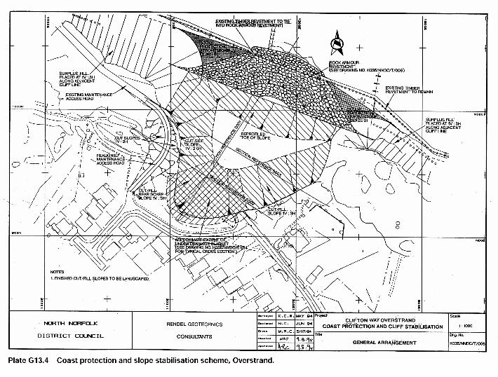
The Overstrand site is located approximately 175m south east of the end of the hard coastal defence measures, a concrete seawall, which protect the bulk of the Overstrand area. Prior to construction of the recent coast protection and slope stabilization scheme at Overstrand, the beach protection measures at the site consisted of an inclined longitudinal revetment sited approximately 25 to 30 metres seaward of the cliff line, together with groynes orientated normal to the cliffline. It is understood that the objective of the longitudinal revetment was to encourage the deposition of beach material behind the structure. This did not occur and in some locations scour hollows developed behind the revetment. Several possible stabilization measures were identified as being technically viable for the Overstrand landslide, although the structural solutions such as retaining walls were considered unacceptable from an environmental viewpoint. The need to maintain the cliff top alignment and minimise encroachment across the beach were severe restrictions on the choice of stabilization options. Due to the highly variable materials within the slipped mass the favoured design had to allow for complete flexibility with regard to modifications during construction. It was considered that an adequate improvement in slope stability could be achieved through reprofiling, draining, and strengthening the slipped mass. Construction of new coast protection and slope stabilization measures was started in March 1995. There were two main elements to the works:- the earthworks on the cliff slopes (including under-drainage) and coast protection in the form of a rock armour revetment. A general arrangement of the proposed remedial works is shown in Figure G13.4. Co-ordination of these two elements was vital if a further failure was to be avoided. Delays in obtaining suitable barge transport for the rock armour meant that significant construction work was not undertaken until the summer. The rock armour was delivered in the middle of the holiday season in July 1995, and the rock was stockpiled on the beach as close to the site as possible and the beach returned to the tourists. Removal of the slip debris was carried out in stages with the surplus material being placed along the toe of the cliff to the east and west of the site. Excavation was extended downwards through the slip material and the underlying beach in to the stable beach material about 1.5 metre below beach level. An incremental approach was adopted so that as each panel of slip debris was removed it was replaced with rock armour. Within the main body of the slip the debris was excavated to below the level of the slip plane. The general sequence adopted by the contractor was to excavate material working down from the top of the slope, cutting benches into the intact soil below the level of the slip plane as the excavation proceeded down the slope. Upon completion of the excavation in a given area a drainage blanket was placed and filling operations commenced. Where potentially more permeable horizons were exposed in the formation, ie sand layers, unpiped french drains were installed beneath the drainage blanket to provide additional flow capacity.
Geotechnical Study Area G13 Overstrand, north Norfolk, UK
7
The earthworks operations were progressed in sections across the site and excavation was permitted only over a narrow frontage so that there was careful control. The method and extent of working was also varied in response to movement of the debris. As well as the under drainage the scheme also incorporated a comprehensive system of surface drainage. The final clay surface was graded and compacted so as to minimise water penetration into the site. A network of piped and unpiped french drains was installed to control surface runoff and erosion.
7. EXPERIENCES, SUCCESSES AND PROBLEMS WITH THE CURRENT APPROACH, AND LESSONS LEARNT
In terms of the depth of land lost, the Overstrand landslide was one of the largest known on the North Norfolk coast. It also confirmed one of the most apparent features of the coastal cliffs in the area -that they are unpredictable in nature. The scale of the slip resulted from a localised, but large pocket of saturated soft silty clay and the highly engineered geotechnical solution prevented further encroachment and loss of land. Traditional methods that just protected the toe of the cliff from erosion would not have achieved the same result. The scheme was regarded as highly successful by local residents and by North Norfolk District Council. One aspect of the scheme that was not entirely successful was that the regraded slopes have not rapidly re-vegetated after re-grading. English Nature prevented re-grassing as the site is designated as a SSSI and they wanted natural vegetation to become established, but this has only happened slowly as the soil type was changed as part of the slope improvement measures. This has proved to be a cosmetic problem rather than a technical failing of the scheme. The study area therefore provides an example of a successful integrated approach to a serious instability problem that has been achieved following a thorough site investigation and good technical design, in consultation with local residents.
8. REFERENCES
Guest S. and Frew. 1997. Geotechnical and other aspects of the Overstrand Coast Protection Scheme. 32nd MAFF Conference of River and Coastal Engineers.
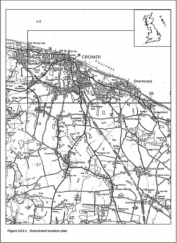
Figure G13.1 Overstrand location plan
Groyne
Groyne
Groyne
Groyne
Groyne
Sand
Sand
coastal slope
Sand & Shingle
Ivy Farm
Park
SCALE0 50 100
metres
APPROXIMATE
EXTENT OF
CLIFF FAILURE
Figure G13.2 Location of cliff failure, Overstrand.
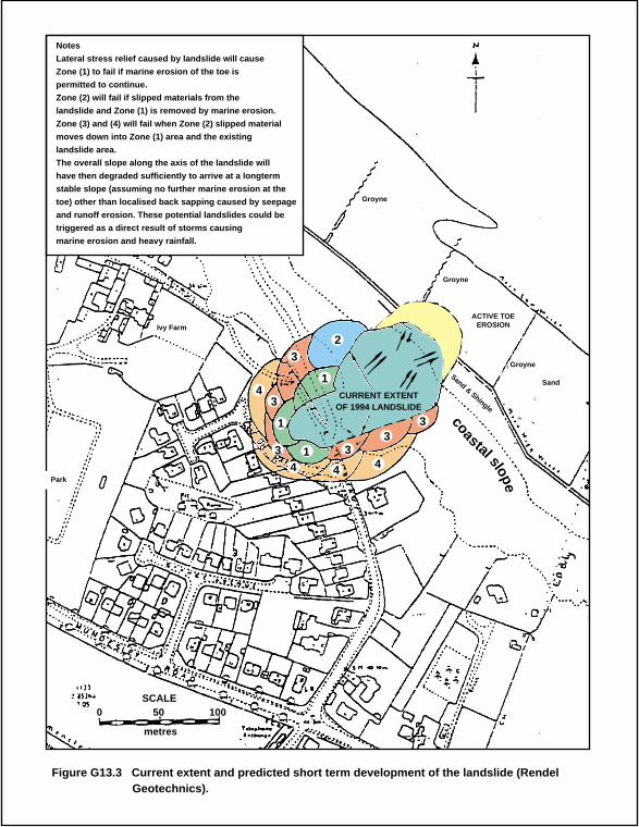
Notes
Lateral stress relief caused by landslide will cause
Zone (1) to fail if marine erosion of the toe is
permitted to continue.
Zone (2) will fail if slipped materials from the
landslide and Zone (1) is removed by marine erosion.
Zone (3) and (4) will fail when Zone (2) slipped material
moves down into Zone (1) area and the existing
landslide area.
The overall slope along the axis of the landslide will
have then degraded sufficiently to arrive at a longterm
stable slope (assuming no further marine erosion at the
toe) other than localised back sapping caused by seepage
and runoff erosion. These potential landslides could be
triggered as a direct result of storms causing
marine erosion and heavy rainfall.
Figure G13.3 Current extent and predicted short term development of the landslide (Rendel Geotechnics).
1
43
4 4
43
32
1
1 33
3
Groyne
Groyne
Groyne
ACTIVE TOEEROSION
Sand
coastal slope
Sand & Shingle
Ivy Farm
Park
SCALE0 50 100
metres
CURRENT EXTENTOF 1994 LANDSLIDE
Geotechnical Study Area G13 Overstrand, north Norfolk, UK
8
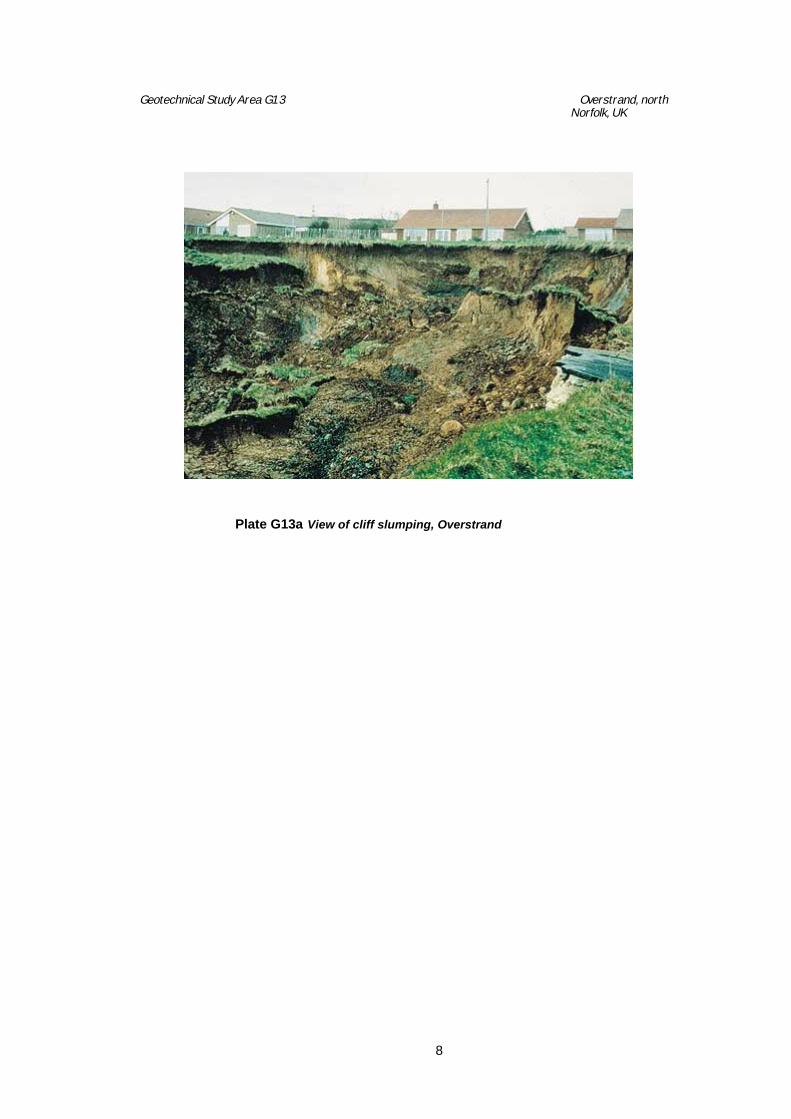
Plate G13a View of cliff slumping, Overstrand