Embed Size (px)
Citation preview

Geoscience Consulting (NZ) Limited 11283_1 5 Norwich Quay, Lyttelton 8082, New Zealand PO Box 110, Lyttelton 8841, New Zealand T (+64) (3) 328 9012 F (+64) (3) 328 9013 www.nzgeoscience.co.nz
GEOTECHNICAL INVESTIGATION
FOSTER BLOCK, GOULDS ROAD
ROLLESTON
SUBMITTED TO:
R.D. HUGHES DEVELOPMENTS LTD
PO BOX 848
CHRISTCHURCH 8140
21 December 2011
DISTRIBUTION
2 Copies – R.D. Hughes Developments Ltd
1 Copy – Geoscience Consulting (NZ) Ltd
Geotechnical Investigation – Foster Block, Goulds Road, Rolleston
11283_1 2
21 December 2011
CONTENTS
1 INTRODUCTION 3
2 SITE DESCRIPTION 3
3 GEOLOGY 4
4 GEOHAZARDS 4
4.1 Seismicity 4
4.2 Liquefaction and Lateral Spreading 4
5 FIELD INVESTIGATIONS 4
5.1 Test Pits 4
5.2 AutoScala (Penetrometer) Testing 5
5.3 Environment Canterbury (ECan) Borehole Logs 5
5.3.1 Groundwater 5
6 CONCLUSIONS 6
7 RECOMMENDATIONS 6
8 REFERENCES 6
9 LIMITATIONS 7
TABLES
Table 1: Summary of Typical Subsurface Conditions
FIGURES
Figure 1: Site Location Plan
APPENDICES
Appendix 1: Site Photographs
Appendix 2: Test Pit Logs
Appendix 3: AutoScala (Penetrometer) Logs
Appendix 4; ECan Borehole Logs
Geotechnical Investigation – Foster Block, Goulds Road, Rolleston
11283_1 3
21 December 2011
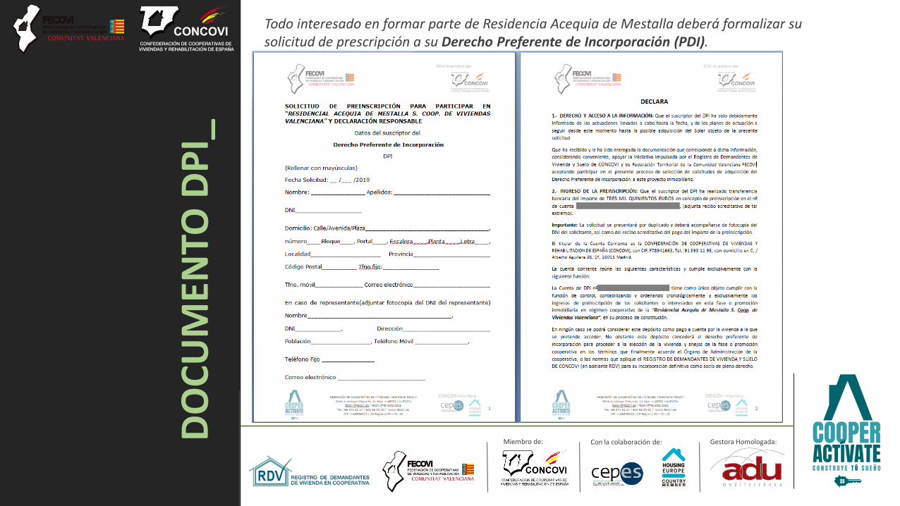
1 INTRODUCTION
Geoscience Consulting (NZ) Ltd (Geoscience) was requested by Kelvin Back of R.D. Hughes Developments Ltd to undertake a preliminary geotechnical investigation of a proposed residential sub-division site on Goulds Road, Rolleston (herein referred to as ‘the site’) as outlined in our proposal (ref. P11382, dated 9th November 2011).
We understand the site has recently been rezoned from rural to residential and that this report was commissioned in order to provide sufficient information for Geoscience to comment on the likely ‘Technical Category’1 into which this land will fall. This report is not intended for 224c sub-division sign off or for building consent purposes. The Selwyn District Council guidelines indicate further geotechnical testing may be required for these consents. A final report will be provided following earthworks to confirm the site technical category. We assume this will be required as a condition of subdivision consent.
Our scope of works included the following:
Desktop study of relevant publically available geotechnical and geological publications;
Undertake a visual inspection of the site to identify land damage following the recent earthquakes;
Organise and technical supervision approximately 12 test pits to depths of between 1 and 4 m.
Arrange for a sub-contractor to complete approximately 80 Mechanical Scala Penetrometer tests across the site to a target depth of 1-2 m.
Presentation of a report outlining our findings on the prevailing ground conditions and including our opinion as to the appropriate ‘Technical Category’ for the site. This will include a comment on the likely liquefaction potential at the site. We will also outline what further geotechnical work we consider will be required for sub-division consent.
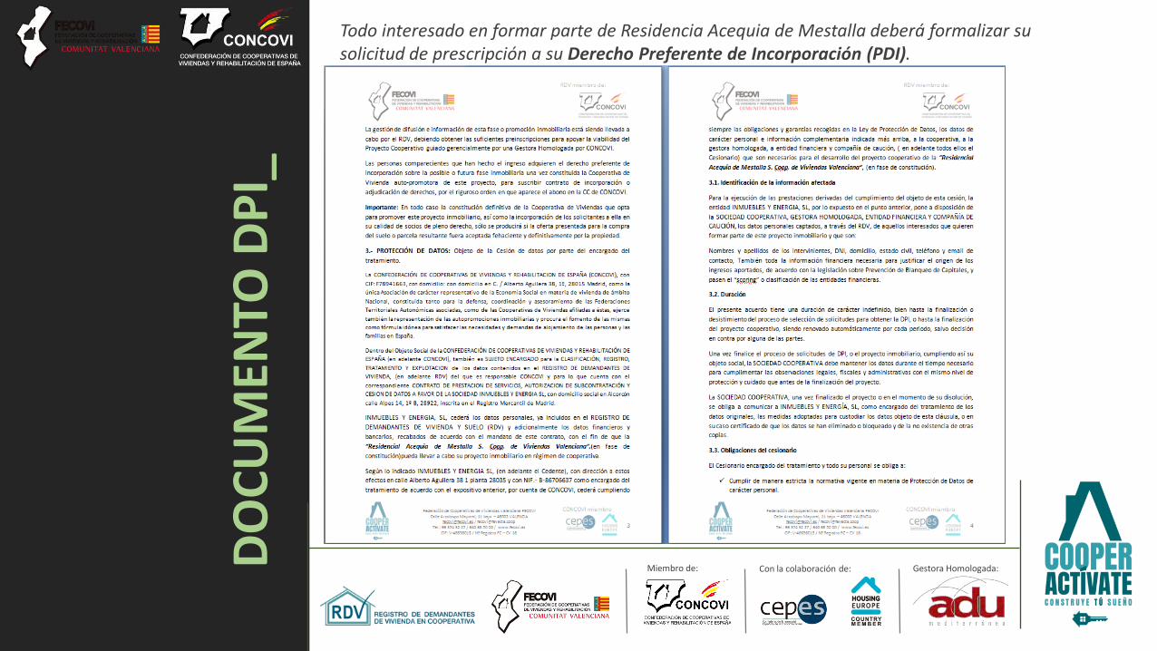
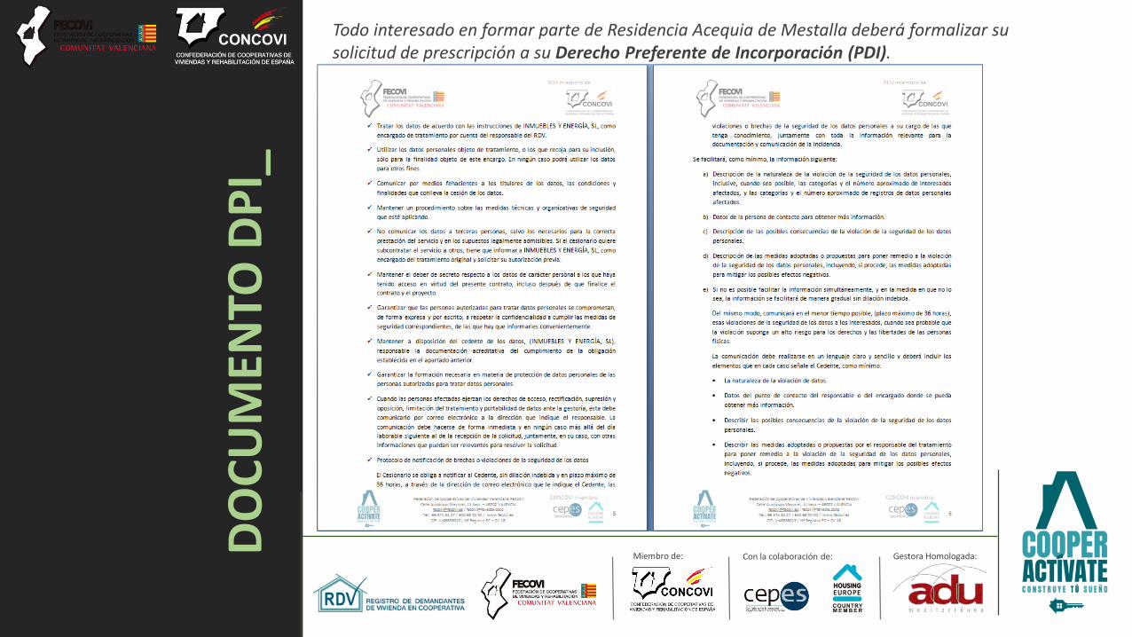
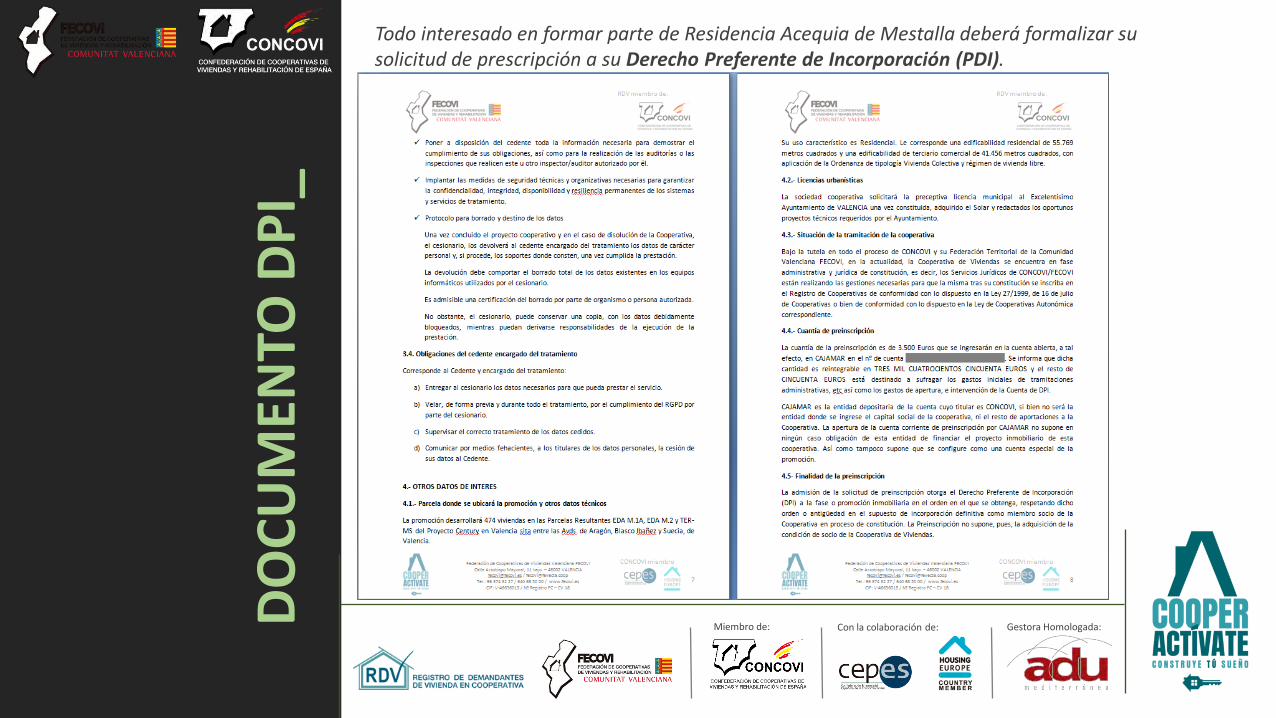
2 SITE DESCRIPTION
The site is located on relatively flat ground approximately 2 km southeast of the centre of Rolleston. The site is bound by Dynes Road to the northwest, Goulds Road to the West, East Maddisons Road to the southwest and farmland to the southeast and northeast (Figure 1). The site is currently used for a mixture of grazing and cropping. There are no significant watercourses in the area.
The Department of Building and Housing (DBH) has recently divided the CERA ‘Green Zone’ into the following Technical Categories1:
TC1 (‘Grey’) where “future land damage from liquefaction is unlikely, and ground settlements are expected to be within normally accepted tolerances”;
TC2 (‘Yellow’) where “minor to moderate land damage from liquefaction is possible in future large earthquakes”; and
TC3 (‘Blue’) where “moderate to significant land damage from liquefaction is possible in future significant earthquakes”.
The site does not yet have a classification and it was the aim of this report to give an indication as to what category we consider the land will fall into.
Site photographs are presented in Appendix 1.
Geotechnical Investigation – Foster Block, Goulds Road, Rolleston
11283_1 4
21 December 2011
3 GEOLOGY
The site is mapped2 as being underlain by brownish grey river alluvium.
4 GEOHAZARDS
4.1 Seismicity
Historically, Christchurch City has been considered to be in a region of low concentrations of active faults and seismicity. However, the Canterbury region has recently had three earthquakes with magnitude greater than 6. As a result, there is a heightened level of seismic risk stemming from the recently discovered Greendale, Lyttelton and Port Hills Faults. The recent seismic activity in the Canterbury region is currently considered to have increased the probability of another large (M6.0-6.9) earthquake to 21%3 between the time of writing and November 2012.
Preliminary mapping4 of the recent faulting in Canterbury illustrates the approximate locations of the Greendale Fault and sub-surface Lyttelton Fault rupture, the distribution of associated aftershocks since the 4th of September 2010 event, and known active faults in the Canterbury area. Large regional areas of faulting2,5 namely the Ashley Fault, Porters Pass-Amberley Fault Zone, and the Hope and Alpine Faults, are further afield but present a high seismic hazard risk to the Christchurch area due to the anticipated size of earthquakes generated. The largest of these faults is the Alpine Fault, which has a return period of 250-300 years and is expected to produce a M8 earthquake. The last rupture on the Alpine Fault is believed to have occurred in 17176.
4.2 Liquefaction and Lateral Spreading
The site is located outside the “potentially liquefiable ground zone” and “lateral spread zone” identified by the Selwyn District Council7, and we consider the potential for liquefaction and lateral spreading to be very low owing to the nature of the subsurface materials1 and depth to groundwater at the site.
Aerial photography8 taken in the days following the 22nd of February event shows no sign of any ejected sand and silt at the site and surrounding areas. We are unaware of any liquefaction or lateral spreading being observed within approximately 20 km of the site during the recent large earthquakes affecting the Canterbury region.
5 FIELD INVESTIGATIONS
5.1 Test Pits
Geoscience visited the site on the 30th of November 2011 and completed logging of materials from 12 machine excavated test pits. Our investigations found the geology to be consistent with published mapping, as summarised in Table 1.

Geotechnical Investigation – Foster Block, Goulds Road, Rolleston
11283_1 5
21 December 2011
Table 1: Summary of Typical Subsurface Conditions
Depth (m) Material Description Material Type Density/Consistency
0.0 to 0.3 SILT with trace to minor sand, dark brown, dry. TOPSOIL Stiff
0.3 to 4.0 Sandy fine to coarse GRAVEL, brown, well graded, rounded, dry. Some SAND lenses (<0.2 m) ALLUVIUM
Very Dense
>4.0 Inferred GRAVEL Very Dense
Groundwater was not encountered in any of the test pits.
Full logs are presented in Appendix 2 and are written in accordance with the New Zealand Geotechnical Society ‘Guideline for the Field Classification and Description of Soil and Rock for Engineering Purposes’9.
5.2 AutoScala (Penetrometer) Testing
The AutoScala is a small mechanical rig that pushes a Scala Penetrometer cone into the ground. A total of 91 tests were carried out approximately every 100 m across the site by Canterbury Geotest to a maximum depth of 1.2 m below ground level. The AutoScala tests were undertaken to assess the subsurface strength profile and to help determine if ground beneath the site meets the requirements of static “good ground”, defined in NZS 3604:201110 as follows:
“Where the number of blows per 100 mm depth of penetration below the underside of the proposed footing at each test site exceeds:
5 down to a depth equal to twice the width of the widest footing; and
3 at greater depths.
Furthermore, the definition of “good ground” also excludes organic topsoil, soft or very soft peat, soft or very soft clay and / or uncertified fill below the depth of footing at any test site. Sites prone to liquefaction also do not meet under the definition of “good ground”.
“Good ground” under static conditions was typically encountered immediately beneath the topsoil layer (on average 0.3 m) and at a maximum depth of 0.45 m below ground level.
AutoScala results including a summary sheet are presented in Appendix 3.
5.3 Environment Canterbury (ECan) Borehole Logs
A review was conducted of deep ECan borehole logs in the general area. A total of four representative borelogs from holes located either on or immediately adjacent to the site were reviewed. The logs from these holes are presented in Appendix 4 and indicate the site is underlain by a mixture of claybound and sandy gravels to depths of at least 114 m below ground level. Some minor clay and peat layers are recorded below approximately 28 m depth in some of the boreholes. None of these materials are prone to liquefaction.
5.3.1 Groundwater
Groundwater is recorded on the ECan borehole logs at depths ranging from 9 to 11 m below ground level.

Geotechnical Investigation – Foster Block, Goulds Road, Rolleston
11283_1 6
21 December 2011
6 CONCLUSIONS
Based on our site investigation and assessment we conclude the following:
Geotechnical materials underlying the site typically comprise of 0.3 m of topsoil underlain by very dense gravel to depths of at least several tens of metres and probably hundreds of metres depth.
AutoScala testing indicates “good ground” can typically be found immediately below the topsoil layer and at a maximum depth of 0.45 m.
ECan borehole logs in the area indicate groundwater can be found at between 9 and 11 m below ground level.
There is no evidence of any liquefaction having occurred at or near the site during recent large earthquakes. We consider the likelihood of liquefaction or lateral spreading occurring at the site to be very low based on the depth to groundwater and the nature of the sub-surface materials (namely gravel).
7 RECOMMENDATIONS
Based on our findings we consider the site characteristics to be consistent with a Technical Category 1 (TC1) classification where:
“Future land damage from liquefaction is unlikely. You can use standard foundations for concrete slabs or timber floors. Foundation requirements changed in 2011 and information is available on the Department of Building and Housing’s website”1:
It should be noted that while we consider the site suitable for residential sub-division, this report is not intended for 224c sub-division sign off or for building consent purposes. The Selwyn District Council guidelines indicate further geotechnical testing may be required for these consents. A final report will be provided following earthworks to confirm the site technical category. We assume this will be required as a condition of subdivision consent.
8 REFERENCES
1 The Department of Building and Housing, October 2011: Preview of the Update to: Guidance on House Repairs and Reconstruction following the Canterbury Earthquakes (http://www.dbh.govt.nz/earthquake--reconstruction-guidance-preview)
2 Brown, L.J., Weeber, J.H., 1992: Sheet 1 - Geology of the Christchurch Urban Area 1:25,000. Institute of Geological and Nuclear Sciences, Lower Hutt.
3 http://www.geonet.org.nz/var/storage/images/media/images/news/2011/chch_seismicity_04_09_11/58577-1-eng-GB/Chch_Seismicity_04_09_11.jpg
4 http://www.geonet.org.nz/canterbury-quakes/aftershocks/ 5 Rattenbury, M.S.; Townsend, D.B.; Johnston, M.R., 2006: Sheet 13 - Geology of the Kaikoura
Area 1:250,000. Institute of Geological and Nuclear Sciences, Lower Hutt. 6 Pettinga J.R., Yetton M.D., Van Dissen R.J., and Downes G., 2001: Earthquake Source
Identification and Characterisation for the Canterbury Region, South Island, New Zealand, Bulletin of the New Zealand Society for Earthquake Engineering, Vol 34, No. 4, pp 282-317
7 Selwyn District Council 2011: 2010 Canterbury Earthquake Liquefaction Report, Issue 05.6; Prepared by Geotech Consulting Ltd.
8 http://koordinates.com/#/layer/3185-christchurch-post-earthquake-aerial-photos-24-feb-2011/

Geotechnical Investigation – Foster Block, Goulds Road, Rolleston
11283_1 7
21 December 2011
9 New Zealand Geotechnical Society, 2005: Guideline for the Field Classification and Description of Soil and Rock for Engineering Purposes.
10 Standards Association of New Zealand, 2011: Timber Framed Buildings – New Zealand, NZS 3604:2011. Standards New Zealand, Wellington.
We also acknowledge the New Zealand GeoNet project and its sponsors EQC, GNS Science and LINZ, for providing data used in this report.
9 LIMITATIONS
(i) This report has been prepared for the use of our client, R.D. Hughes Developments Ltd, their professional advisers and the relevant Territorial Authorities in relation to the specified project brief described in this report. No liability is accepted for the use of any part of the report for any other purpose or by any other person or entity.
(ii) Assessments made in this report are based on the ground conditions indicated from published sources, site inspections and subsurface investigations described in this report based on accepted normal methods of site investigations. Variations in ground conditions may exist between test locations and therefore have not been taken into account in the report.
(iii) This Limitation should be read in conjunction with the IPENZ/ACENZ Standard Terms of Engagement.
We trust that this information meets your current requirements. Please do not hesitate to contact the undersigned on 03 328 9012 if you require any further information.
For and on behalf of Geoscience Consulting (NZ) Ltd,
Greg Martin
Associate Engineering Geologist

Geoscience Consulting (NZ) Limited 5 Norwich Quay, Lyttelton 8062, New Zealand PO Box 110, Lyttelton 8841, New Zealand T (+64) (3) 328 9012 F (+64) (3) 328 9013 www.nzgeoscience.co.nz
FIGURES

NTS 1 11283_1Project NumberScale Figure Number
Approved by MW
Foster Block, Goulds Road, RollestonProject
Description Site Location Plan
CM
Hughes Construction LtdClientDate
Drawn by
Nov-11
N
AutoScala Test Location
= Test Pit Location
Note:
Map and aerial photograph courtesy of Google Maps
TP07
XSite Location
N
SP7
SP90
SP71
SP74
SP55
SP59
SP31
SP30
SP21
SP19
SP20
SP22
SP25
SP32
SP33
SP60
SP57
SP58
SP61
SP75
SP76
SP73
SP70
SP89
SP88
SP91
SP80
SP72SP81
SP77 SP56SP62
SP34 SP24
SP18
SP23
SP5
SP4
SP10
SP17
SP35
SP54
SP63
SP69
SP68
SP79
SP78
SP64
SP65
SP45
SP46
SP36
SP27
SP11
SP3
SP12
SP16SP37
SP52
SP53SP67
SP66SP47
SP51
SP38SP15
SP29
SP2
SP13
SP1
SP28
SP14
SP26
SP40
SP39
SP49
SP48SP50
SP6
TP05
TP11
SP8
SP9
SP41
SP42
SP43
SP44
SP82
SP83 & SP84
SP85
SP86
SP87
TP10
TP09
TP08
TP12
TP06
TP04
TP03
TP02
TP01
Geoscience Consulting (NZ) Limited 5 Norwich Quay, Lyttelton 8062, New Zealand PO Box 110, Lyttelton 8841, New Zealand T (+64) (3) 328 9012 F (+64) (3) 328 9013 www.nzgeoscience.co.nz
APPENDIX 1
Site Photographs
N/A 1 to 6
Photo 1: View looking north east from centre of site. Photo 3: View looking south east.Photo 2: View looking south.
Photo 4: View looking west. Photo 6: Gravel removed from Test Pit.Photo 5: View of sub surface material in Test Pit 1.
Date taken 30/11/11 Client R. D. Hughes Developments Ltd
Taken by RC Project Foster Block, Goulds Road, Rolleston
Approved by GM Description Site Photographs
Scale Photo No. Project Number 11283_1
Geoscience Consulting (NZ) Limited 5 Norwich Quay, Lyttelton 8062, New Zealand PO Box 110, Lyttelton 8841, New Zealand T (+64) (3) 328 9012 F (+64) (3) 328 9013 www.nzgeoscience.co.nz
APPENDIX 2
Test Pit Logs

Material
Material
Graphic Log
Depth (m)
2
TP01
Project: Foster Block
Test Pit No.
R. D. Hughes Developments LtdClient:
Shear Vane
Excavation Dimensions: 3.00by2.00
Machine Type: 16 Tonne Digger
Vane No.: N/A
Engineering Log - Test Pit
1 of 1Sheet
11283Project No.
Principal: Kelvin Back
Test Pit Location: Refer to Site Location Plan
30/11/2011Date Started:
30/11/2011Date Completed:
JC/RCLogged By:
GMChecked By:
Excavation Information Material Substance
Soil - soil type, colour, structure, grading, bedding, plasticity, sensitivity; Secondary and minor components
Rock - colour, fabric, rock type; discontinuities; additional information
Classification
Symbol
Water Notes,
samples, tests etc
Moisture
Condition
Consistency /
Density Index
8
(Dial Readings kPa)
Scala(Blows/100mm)
4 6
EOH: 3.6 m
Termination: Target depthNotes:
Met target depth at 3.6 m. No groundwater encountered.
SILT with minor sand; dark brown. Low plasticity. [TOPSOIL]
Sandy fine to coarse GRAVEL; brown, rounded, well graded. Sand is medium to coarse.
Coarse SAND lense.
Coarse SAND lense.
0.2
0.4
0.6
0.8
1
1.2
1.4
1.6
1.8
2
2.2
2.4
2.6
2.8
3
3.2
3.4
3.6
ML
D St
GW
D MD
GW
D-M MD
GW
TOPSOIL
ALLUVIUM
Sketch/Photo

Material
Material
Graphic Log
Depth (m)
2
TP02
Project: Foster Block
Test Pit No.
R. D. Hughes Developments LtdClient:
Shear Vane
Excavation Dimensions: 3.00by2.00
Machine Type: 16 Tonne Digger
Vane No.: N/A
Engineering Log - Test Pit
1 of 1Sheet
11283Project No.
Principal: Kelvin Back
Test Pit Location: Refer to Site Location Plan
30/11/2011Date Started:
30/11/2011Date Completed:
JC/RCLogged By:
GMChecked By:
Excavation Information Material Substance
Soil - soil type, colour, structure, grading, bedding, plasticity, sensitivity; Secondary and minor components
Rock - colour, fabric, rock type; discontinuities; additional information
Classification
Symbol
Water Notes,
samples, tests etc
Moisture
Condition
Consistency /
Density Index
8
(Dial Readings kPa)
Scala(Blows/100mm)
4 6
EOH: 3 m
Termination: Target depthNotes:
Met target depth at 3.0 m. No groundwater encountered.
SILT with trace fine sand; dark brown, friable. Low plasticity. [TOPSOIL]
Sandy fine to coarse GRAVEL; brown, rounded, well graded. Sand is fine to coarse.
0.2
0.4
0.6
0.8
1
1.2
1.4
1.6
1.8
2
2.2
2.4
2.6
2.8
3
MLD St
GW
D MD
GW
D-M D
TOPSOIL
ALLUVIUM
Sketch/Photo
Material
Material
Graphic Log
Depth (m)
2
TP03
Project: Foster Block
Test Pit No.
R. D. Hughes Developments LtdClient:
Shear Vane
Excavation Dimensions: 3.00by2.00
Machine Type: 16 Tonne Digger
Vane No.: N/A
Engineering Log - Test Pit
1 of 1Sheet
11283Project No.
Principal: Kelvin Back
Test Pit Location: Refer to Site Location Plan
30/11/2011Date Started:
30/11/2011Date Completed:
JC/RCLogged By:
GMChecked By:
Excavation Information Material Substance
Soil - soil type, colour, structure, grading, bedding, plasticity, sensitivity; Secondary and minor components
Rock - colour, fabric, rock type; discontinuities; additional information
Classification
Symbol
Water Notes,
samples, tests etc
Moisture
Condition
Consistency /
Density Index
8
(Dial Readings kPa)
Scala(Blows/100mm)
4 6
EOH: 4 m
Termination: Target depthNotes:
Met target depth at 4.0 m. No groundwater encountered.
SILT with trace fine sand; dark brown, friable. Low plasticity. [TOPSOIL]
Sandy fine to coarse GRAVEL; brown, well graded, rounded. Sand is fine to coarse.
0.2
0.4
0.6
0.8
1
1.2
1.4
1.6
1.8
2
2.2
2.4
2.6
2.8
3
3.2
3.4
3.6
3.8
4
MLD St
GW
D-M MD
TOPSOIL
ALLUVIUM
Sketch/Photo
Material
Material
Graphic Log
Depth (m)
2
TP04
Project: Foster Block
Test Pit No.
R. D. Hughes Developments LtdClient:
Shear Vane
Excavation Dimensions: 3.00by2.00
Machine Type: 16 Tonne Digger
Vane No.: N/A
Engineering Log - Test Pit
1 of 1Sheet
11283Project No.
Principal: Kelvin Back
Test Pit Location: Refer to Site Location Plan
30/11/2011Date Started:
30/11/2011Date Completed:
JC/RCLogged By:
GMChecked By:
Excavation Information Material Substance
Soil - soil type, colour, structure, grading, bedding, plasticity, sensitivity; Secondary and minor components
Rock - colour, fabric, rock type; discontinuities; additional information
Classification
Symbol
Water Notes,
samples, tests etc
Moisture
Condition
Consistency /
Density Index
8
(Dial Readings kPa)
Scala(Blows/100mm)
4 6
EOH: 2 m
Termination: Target depthNotes:
Met target depth at 2.0 m. No groundwater encountered.
SILT with trace sand; dark brown, friable. Low plasticity. [TOPSOIL]
Sandy fine to coarseGRAVEL; brown, well graded, rounded. Sand is fine to coarse.
Medium SAND lense
0.2
0.4
0.6
0.8
1
1.2
1.4
1.6
1.8
2
MLD St
GW
D D
GW D-M D
TOPSOIL
ALLUVIUM
Sketch/Photo
Material
Material
Graphic Log
Depth (m)
2
TP05
Project: Foster Block
Test Pit No.
R. D. Hughes Developments LtdClient:
Shear Vane
Excavation Dimensions: 3.00by2.00
Machine Type: 16 Tonne Digger
Vane No.: N/A
Engineering Log - Test Pit
1 of 1Sheet
11283Project No.
Principal: Kelvin Back
Test Pit Location: Refer to Site Location Plan
30/11/2011Date Started:
30/11/2011Date Completed:
JC/RCLogged By:
GMChecked By:
Excavation Information Material Substance
Soil - soil type, colour, structure, grading, bedding, plasticity, sensitivity; Secondary and minor components
Rock - colour, fabric, rock type; discontinuities; additional information
Classification
Symbol
Water Notes,
samples, tests etc
Moisture
Condition
Consistency /
Density Index
8
(Dial Readings kPa)
Scala(Blows/100mm)
4 6
EOH: 3 m
Termination: Target depthNotes:
Met target depth at 3.0 m. No groundwater encountered.
SILT with minor sand; dark brown, friable. Low plasticity. [TOPSOIL]
Fine to medium SAND; brown, poorly graded.
Sandy fine to coarse GRAVEL; brown, rounded, well graded. Sand is fine to coarse.
0.2
0.4
0.6
0.8
1
1.2
1.4
1.6
1.8
2
2.2
2.4
2.6
2.8
3
MLD St
SPD L
GW
D-M MD
TOPSOIL
ALLUVIUM
Sketch/Photo
Material
Material
Graphic Log
Depth (m)
2
TP06
Project: Foster Block
Test Pit No.
R. D. Hughes Developments LtdClient:
Shear Vane
Excavation Dimensions: 3.00by2.00
Machine Type: 16 Tonne Digger
Vane No.: N/A
Engineering Log - Test Pit
1 of 1Sheet
11283Project No.
Principal: Kelvin Back
Test Pit Location: Refer to Site Location Plan
30/11/2011Date Started:
30/11/2011Date Completed:
JC/RCLogged By:
GMChecked By:
Excavation Information Material Substance
Soil - soil type, colour, structure, grading, bedding, plasticity, sensitivity; Secondary and minor components
Rock - colour, fabric, rock type; discontinuities; additional information
Classification
Symbol
Water Notes,
samples, tests etc
Moisture
Condition
Consistency /
Density Index
8
(Dial Readings kPa)
Scala(Blows/100mm)
4 6
EOH: 3 m
Termination: Target depthNotes:
Met target depth at 3.0 m. No groundwater encountered.
SILT with trace sand; dark brown. Low plasticity. [TOPSOIL]
Sandy fine to coarse GRAVEL; brown, well graded, rounded. Sand is fine to coarse.
0.2
0.4
0.6
0.8
1
1.2
1.4
1.6
1.8
2
2.2
2.4
2.6
2.8
3
ML D St
GW
D MDTOPSOIL
ALLUVIUM
Sketch/Photo
Material
Material
Graphic Log
Depth (m)
2
TP07
Project: Foster Block
Test Pit No.
R. D. Hughes Developments LtdClient:
Shear Vane
Excavation Dimensions: 3.00by2.00
Machine Type: 16 Tonne Digger
Vane No.: N/A
Engineering Log - Test Pit
1 of 1Sheet
11283Project No.
Principal: Kelvin Back
Test Pit Location: Refer to Site Location Plan
30/11/2011Date Started:
30/11/2011Date Completed:
JC/RCLogged By:
GMChecked By:
Excavation Information Material Substance
Soil - soil type, colour, structure, grading, bedding, plasticity, sensitivity; Secondary and minor components
Rock - colour, fabric, rock type; discontinuities; additional information
Classification
Symbol
Water Notes,
samples, tests etc
Moisture
Condition
Consistency /
Density Index
8
(Dial Readings kPa)
Scala(Blows/100mm)
4 6
EOH: 2 m
Termination: Target depthNotes:
Met target depth at 2.0 m. No groundwater encountered.
SILT with minor sand; dark brown. Low plasticity. [TOPSOIL]
Sandy fine to coarse GRAVEL; brown, rounded, well graded. Sand is medium to coarse.
0.2
0.4
0.6
0.8
1
1.2
1.4
1.6
1.8
2
MLD St
GW
D MD
TOPSOIL
ALLUVIUM
Sketch/Photo
Material
Material
Graphic Log
Depth (m)
2
TP08
Project: Foster Block
Test Pit No.
R. D. Hughes Developments LtdClient:
Shear Vane
Excavation Dimensions: 3.00by2.00
Machine Type: 16 Tonne Digger
Vane No.: N/A
Engineering Log - Test Pit
1 of 1Sheet
11283Project No.
Principal: Kelvin Back
Test Pit Location: Refer to Site Location Plan
30/11/2011Date Started:
30/11/2011Date Completed:
JC/RCLogged By:
GMChecked By:
Excavation Information Material Substance
Soil - soil type, colour, structure, grading, bedding, plasticity, sensitivity; Secondary and minor components
Rock - colour, fabric, rock type; discontinuities; additional information
Classification
Symbol
Water Notes,
samples, tests etc
Moisture
Condition
Consistency /
Density Index
8
(Dial Readings kPa)
Scala(Blows/100mm)
4 6
EOH: 2.3 m
Termination: Target depthNotes:
Met target depth at 2.3 m. No groundwater encountered.
SILT with minor sand; dark brown. Low plasticity. [TOPSOIL]
Silty fine SAND; light brown. Well graded.Sandy fine to coarse GRAVEL; brown, rounded, well graded. Sand is fine to coarse.
0.2
0.4
0.6
0.8
1
1.2
1.4
1.6
1.8
2
2.2
MLD St
SM D L
GW
D L-MD
TOPSOIL
ALLUVIUM
Sketch/Photo
Material
Material
Graphic Log
Depth (m)
2
TP09
Project: Foster Block
Test Pit No.
R. D. Hughes Developments LtdClient:
Shear Vane
Excavation Dimensions: 3.00by2.00
Machine Type: 16 Tonne Digger
Vane No.: N/A
Engineering Log - Test Pit
1 of 1Sheet
11283Project No.
Principal: Kelvin Back
Test Pit Location: Refer to Site Location Plan
30/11/2011Date Started:
30/11/2011Date Completed:
JC/RCLogged By:
GMChecked By:
Excavation Information Material Substance
Soil - soil type, colour, structure, grading, bedding, plasticity, sensitivity; Secondary and minor components
Rock - colour, fabric, rock type; discontinuities; additional information
Classification
Symbol
Water Notes,
samples, tests etc
Moisture
Condition
Consistency /
Density Index
8
(Dial Readings kPa)
Scala(Blows/100mm)
4 6
EOH: 2 m
Termination: Target depthNotes:
Met target depth at 2.0 m. No groundwater encountered.
SIlt with trace sand; dark brown. Low plasticity. [TOPSOIL]
Sandy fine to coarse GRAVEL; brown, well graded, rounded. Sand is fine to coarse.
0.2
0.4
0.6
0.8
1
1.2
1.4
1.6
1.8
2
ML D St
GW
D D
TS
ALLUVIUM
Sketch/Photo
Material
Material
Graphic Log
Depth (m)
2
TP10
Project: Foster Block
Test Pit No.
R. D. Hughes Developments LtdClient:
Shear Vane
Excavation Dimensions: 3.00by2.00
Machine Type: 16 Tonne Digger
Vane No.: N/A
Engineering Log - Test Pit
1 of 1Sheet
11283Project No.
Principal: Kelvin Back
Test Pit Location: Refer to Site Location Plan
30/11/2011Date Started:
30/11/2011Date Completed:
JC/RCLogged By:
GMChecked By:
Excavation Information Material Substance
Soil - soil type, colour, structure, grading, bedding, plasticity, sensitivity; Secondary and minor components
Rock - colour, fabric, rock type; discontinuities; additional information
Classification
Symbol
Water Notes,
samples, tests etc
Moisture
Condition
Consistency /
Density Index
8
(Dial Readings kPa)
Scala(Blows/100mm)
4 6
EOH: 2 m
Termination: Target depthNotes:
Met target depth at 2.0 m. No groundwater encountered.
SILT with trace sand; dark brown. Low plasticity. [TOPSOIL]
Sandy fine to coarse GRAVEL; brown, well graded, rounded. Sand is fine to medium.
Medium SAND lense.
0.2
0.4
0.6
0.8
1
1.2
1.4
1.6
1.8
2
ML D St
GW
D L-MD
GW
TOPSO
ALLUVIUM
Sketch/Photo
Material
Material
Graphic Log
Depth (m)
2
TP11
Project: Foster Block
Test Pit No.
R. D. Hughes Developments LtdClient:
Shear Vane
Excavation Dimensions: 3.00by2.00
Machine Type: 16 Tonne Digger
Vane No.: N/A
Engineering Log - Test Pit
1 of 1Sheet
11283Project No.
Principal: Kelvin Back
Test Pit Location: Refer to Site Location Plan
30/11/2011Date Started:
30/11/2011Date Completed:
JC/RCLogged By:
GMChecked By:
Excavation Information Material Substance
Soil - soil type, colour, structure, grading, bedding, plasticity, sensitivity; Secondary and minor components
Rock - colour, fabric, rock type; discontinuities; additional information
Classification
Symbol
Water Notes,
samples, tests etc
Moisture
Condition
Consistency /
Density Index
8
(Dial Readings kPa)
Scala(Blows/100mm)
4 6
EOH: 2.5 m
Termination: Target depthNotes:
Met target depth at 2.5 m. No groundwater encountered.
SILT with trace sand; dark brown. Low plasticity. [TOPSOIL]
Sandy fine to coarse GRAVEL; brown, rounded, well graded. Sand is fine to medium.
Medium SAND lense.
Medium SAND lense.
0.2
0.4
0.6
0.8
1
1.2
1.4
1.6
1.8
2
2.2
2.4
ML D St
GW
D MD
GW L
GW
TOPSO
ALLUVIUM
Sketch/Photo

Material
Material
Graphic Log
Depth (m)
2
TP12
Project: Foster Block
Test Pit No.
R. D. Hughes Developments LtdClient:
Shear Vane
Excavation Dimensions: 3.00by2.00
Machine Type: 16 Tonne Digger
Vane No.: N/A
Engineering Log - Test Pit
1 of 1Sheet
11283Project No.
Principal: Kelvin Back
Test Pit Location: Refer to Site Location Plan
30/11/2011Date Started:
30/11/2011Date Completed:
JC/RCLogged By:
GMChecked By:
Excavation Information Material Substance
Soil - soil type, colour, structure, grading, bedding, plasticity, sensitivity; Secondary and minor components
Rock - colour, fabric, rock type; discontinuities; additional information
Classification
Symbol
Water Notes,
samples, tests etc
Moisture
Condition
Consistency /
Density Index
8
(Dial Readings kPa)
Scala(Blows/100mm)
4 6
EOH: 2 m
Termination: Target depthNotes:
Met target depth at 2.0 m. No groundwater encountered.
SILT with trace sand; dark brown. Low plasticity. [TOPSOIL]
Fine to medium SAND; light brown. Well graded.
Sandy fine to coarse GRAVEL; brown, well graded, rounded. Sand is fine to coarse.
0.2
0.4
0.6
0.8
1
1.2
1.4
1.6
1.8
2
ML D St
SW D MD
GW
D D
TOPSOIL
ALLUVIUM
Sketch/Photo
Geoscience Consulting (NZ) Limited 5 Norwich Quay, Lyttelton 8062, New Zealand PO Box 110, Lyttelton 8841, New Zealand T (+64) (3) 328 9012 F (+64) (3) 328 9013 www.nzgeoscience.co.nz
APPENDIX 3
AutoScala (Penetrometer) Logs


Geoscience Consulting (NZ) Limited 5 Norwich Quay, Lyttelton 8062, New Zealand PO Box 110, Lyttelton 8841, New Zealand T (+64) (3) 328 9012 F (+64) (3) 328 9013 www.nzgeoscience.co.nz
APPENDIX 4
ECan Borehole Logs