Embed Size (px)
Citation preview
Project No. G1012-52-01C September 19, 2014
LIST OF REFERENCES
1. 2013 California Building Code, California Code of Regulations, Title 24, Part 2, based on the 2012 International Building Code, prepared by California Building Standards Commission, dated July, 2013.
2. ACI 318-11, Building Code Requirements for Structural Concrete and Commentary, prepared by the American Concrete Institute, dated August, 2011.
3. ACI 330-08, Guide for the Design and Construction of Concrete Parking Lots, prepared by the American Concrete Institute, dated June, 2008.
4. Afrouz, A. A., 1992, Practical Handbook of Rock Mass Classifications and Modes of Ground Failure, CRC Press.
5. American Geological Institute, 1982, AGI Data Sheets for Geology in the Field, Laboratory, and Office, second edition, Data Sheet 58.2.
6. ASCE 7-10, Minimum Design Loads for Buildings and Other Structures, Second Printing, April 6, 2011.
7. Bieniawski, Z. T., 1989, Engineering Rock Mass Classifications, Wiley: New York.
8. Boore, D. M. and G. M Atkinson (2008), Ground-Motion Prediction for the Average Horizontal Component of PGA, PGV, and 5%-Damped PSA at Spectral Periods Between 0.01 and 10.0 S, Eartquake Spectra, Volume 24, Issue 1, pages 99-138, February 2008.
9. California Geologic Survey (CGS), 2002, Geologic Map of the Jamul Mountains 7.5′ Quadrangle, San Diego County, California: A Digital Database, scale 1:24,000.
10. California Geological Survey (CGS), 2003, Earthquake Shaking Potential for California, from USGS/CGS Seismic Hazards Model, CSSC No. 03-02.
11. California Geologic Survey, Seismic Shaking Hazards in California, Based on the USGS/CGS Probabilistic Seismic Hazards Assessment (PSHA) Model, edited May 9, 2010. 10% probability of being exceeded in 50 years. http://redirect.conservation.ca.gov/cgs/rghm/pshamap/pshamap.asp
12. Campbell, K. W. and Y. Bozorgnia, NGA Ground Motion Model for the Geometric Mean Horizontal Component of PGA, PGV, PGD and 5% Damped Linear Elastic Response Spectra for Periods Ranging from 0.01 to 10 s, Preprint of version submitted for publication in the NGA Special Volume of Earthquake Spectra, Volume 24, Issue 1, pages 139-171, February 2008.
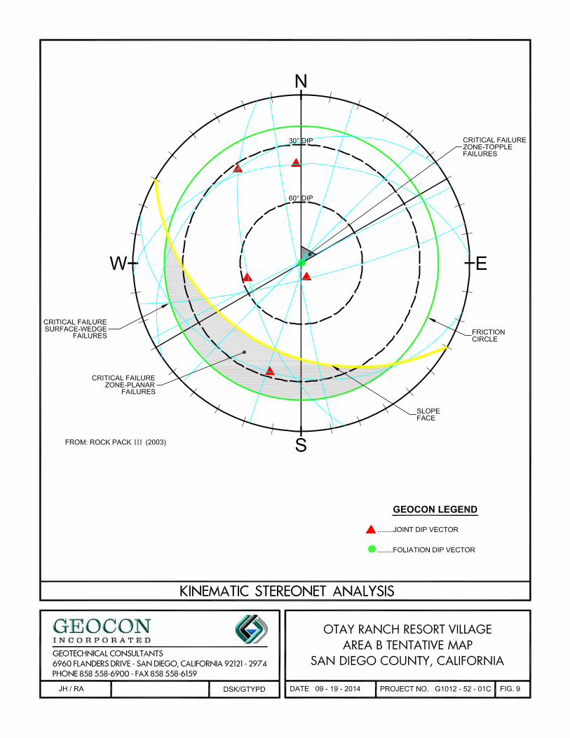
13. C. F. Watts & Associates, 2003, Rockpack III, A Computer Program for the Analysis of Rock Slope Stability.
14. Chiou, Brian S. J. and Robert R. Youngs, A NGA Model for the Average Horizontal Component of Peak Ground Motion and Response Spectra, preprint for article to be published in NGA Special Edition for Earthquake Spectra, Spring 2008.
LIST OF REFERENCES (Continued)
Project No. G1012-52-01C September 19, 2014
15. Geocon Inc., November 16, 2010, Geotechnical Investigation, Otay Ranch Resort Village, Otay Lakes Road Widening and Realignment, San Diego County, California (Project No. G1012-52-01A).
16. Geocon Inc. March 19, 2010, Preliminary Geotechnical Investigation, Otay Ranch Resort Village, San Diego County, California (Project No. G1012-52-01A).
17. Hoek, E. and J. W. Bray, 1981, Rock Slope Engineering, Institution of Mining and Metallurgy.
18. Ishihara, K. (1985), Stability of Natural Deposits During Earthquakes, Proceedings, 11th International Conference on Soil Mechanics and Foundation Engineering, San Francisco, pp. 321-376.
19. Jennings, C. W., 1994, Fault Activity Map of California and Adjacent Areas, California Geologic Data Map Series, Map No. 6.
20. Legg, M. R., J. C. Borrero, and C. E. Synolakis, 2002, Evaluation of Tsunami Risk to Southern California Coastal Cities, 2002 NEHRP Professional Fellowship Report, dated January.
21. Neblett & Associates, 2004, Preliminary Geologic/Geotechnical Feasibility for Environmental Impact Report, Otay Ranch Village 13, City of Chula Vista, County of San Diego, California, dated January 16 (Project No. 362-000-02).
22. Risk Company, EZ-FRISK, (Version 7.62) 2013.
23. Treiman, Jerome A., 1993, The Rose Canyon Fault Zone Southern California, California Division of Mines and Geology Publication.
24. URS, 2004, San Diego County Multi-Jurisdictional Hazard Mitigation Plan, San Diego County, California, dated March 15, (URS Project No. 27653042.00500).
25. U.S. Geological Survey (USGS), 2008, Deaggregation of Seismic Hazard for PGA and 2 Periods of Spectral Acceleration, USGS Website: http://geohazards.usgs.gov/deaggint/2008/.
26. USGS computer program, Seismic Hazard Curves and Uniform Hazard Response Spectra, http://earthquake.usgs.gov/designmaps/us/application.php.
27. Unpublished reports, aerial photographs and maps on file with Geocon Incorporated.
28. Walsh, Stephen L. and Demere, Thomas A., 1991, Age and Stratigraphy of the Sweetwater and Otay Formations, San Diego County California, In Abbott,P. L. and May, J. A., eds., 1991, Eocene Geologic history San Diego Region, Pacific section SEPM, Vol. 68,p. 131-148.