Embed Size (px)
Citation preview


Geotechnical investigation and risk assessment at Budapest metro line 4
Dr. Tibor HorváthGeovil Ltd.
INTERNATIONAL SOCIETY FOR SOIL MECHANICSAND GEOTECHNICAL ENGINEERINGHUNGARIAN NATIONAL COMMITTEE
24th -25th September 2010, Budapest ISSMGE TC 302
“Failures, Disputes, Causes and Solutions in Geotechnics”
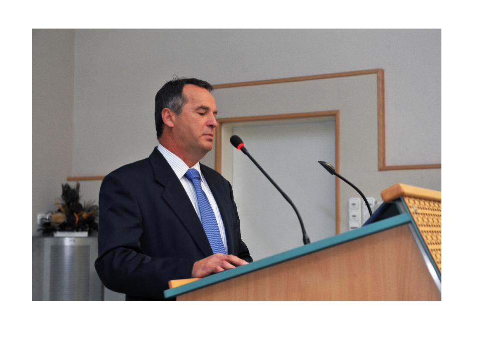
MAIN FEATURES OF METRO LINEMAIN FEATURES OF METRO LINE 4 4
Length of line: 12.7 km
Phase I: 7.4 km
Phase II: 3.2 km
Phase III: 2.1 km
Number of stations: 16
Phase I: 10 stations
Phase II: 4 stations
Phase III: 2 stations
Extensions:
Phase II currently holds licences from both railway and environmental authorities as far as Bosnyák tér, while the planned Phase III would extend as far as the Budaörs Flower Market.
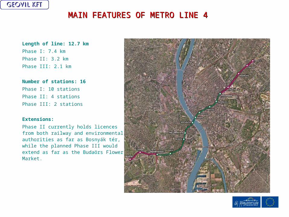
The route proceeds at a relatively shallow depth, at a rail-top level of 16-22 metres below the surface on average, the depth of 32-34 metres under the Danube, passing beneath an almost entirely built-up area and through extremely varied geological strata.
Buda section Danube Pest section

Enginner geological profile of Buda side
Kiscelli marly clay stone, weathered
Kiscelli marly clay stone, fissured
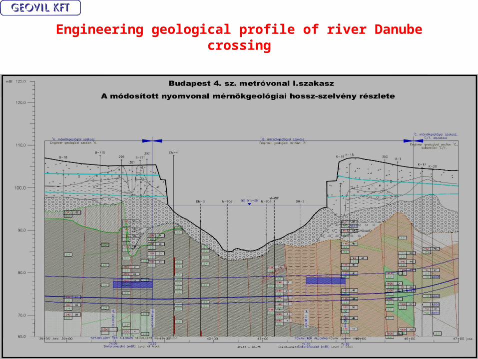
Engineering geological profile of river Danube crossing
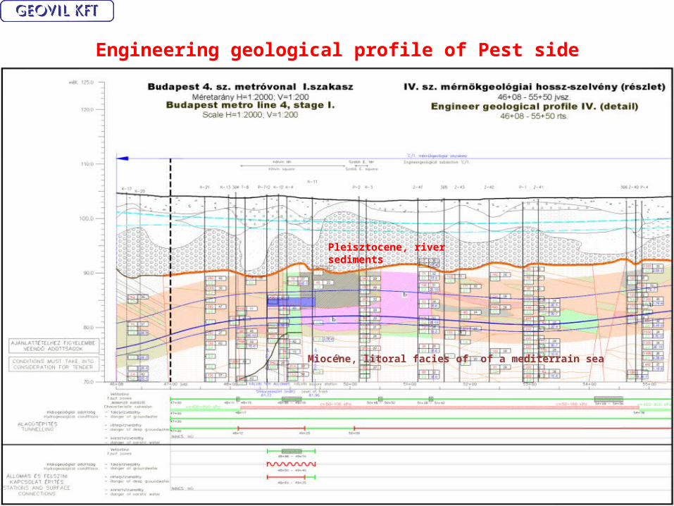
Engineering geological profile of Pest side
Pleisztocene, river sediments
Miocéne, litoral facies of of a mediterrain sea
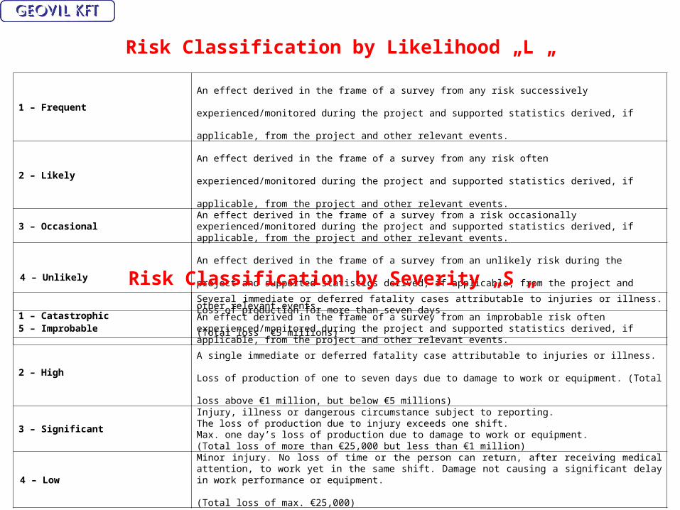
Risk Classification by Likelihood „L „
1 – FrequentAn effect derived in the frame of a survey from any risk successively experienced/monitored during the project and
supported statistics derived, if applicable, from the project and other relevant events.
2 – Likely An effect derived in the frame of a survey from any risk often experienced/monitored during the project and supported
statistics derived, if applicable, from the project and other relevant events.
3 – OccasionalAn effect derived in the frame of a survey from a risk occasionally experienced/monitored during the project and supported statistics derived, if applicable, from the project and other relevant events.
4 – Unlikely An effect derived in the frame of a survey from an unlikely risk during the project and supported statistics derived, if
applicable, from the project and other relevant events.
5 – ImprobableAn effect derived in the frame of a survey from an improbable risk often experienced/monitored during the project and supported statistics derived, if applicable, from the project and other relevant events.
Risk Classification by Severity „S „
1 – Catastrophic
Several immediate or deferred fatality cases attributable to injuries or illness. Loss of production for more than seven days.
(Total loss €5 millions)
2 – HighA single immediate or deferred fatality case attributable to injuries or illness. Loss of production of one to seven days due
to damage to work or equipment. (Total loss above €1 million, but below €5 millions)
3 – Significant
Injury, illness or dangerous circumstance subject to reporting.The loss of production due to injury exceeds one shift.Max. one day’s loss of production due to damage to work or equipment.(Total loss of more than €25,000 but less than €1 million)
4 – Low
Minor injury. No loss of time or the person can return, after receiving medical attention, to work yet in the same shift. Damage not causing a significant delay in work performance or equipment.
(Total loss of max. €25,000)

Risk Assessment Classification Matrix ”RI” (Risk Index)
Risk Severity / Likelihood
1 – Catastrophic 2 – High 3 – Significant 4 – Low
1 – Frequent1 2 3 4
2 – Likely2 4 6 8
3 – Occasional3 6 9 12
4 – Unlikely 4 8 12 16
5 – Improbable5 10 15 20
Risk Index (R) Risk classification Marking
1 – 4Very high V (Very high)V (Very high)
5 – 9High H ( High )H ( High )
10 – 14 Medium M (Medium)M (Medium)15 – 29 Low L (Low)L (Low)
Risk Index, Classification and Marking
• After determining the likelihood and severity of the risk we determined the risk index by means of the assessment matrix.
Risk index = Likelihood of occurrence x Severity of risk
RI = L x S
• The risk index has been calculated for the “starting/initial” cases and the cases yet remaining despite the efforts made to alleviate severity of the risks involved.

Elements of Risk Assessment Arise from Geology, Hydrogeology and Geotechnical features
• General risk from the level of geotechnical investigation, • Personal risk• Third party risk• Environmental risk• Risk of equipments• Risk of program and delay
Annex "A1.": Geotechnical risk level matrix table of Rákóczi Square Station with the section to be built by installing a diaphragm wall
Initial conditions, risks Residual conditions, risks
Risk L S RI RR Reduction L S RI RR Comments
GENERAL RISK FROM THE LEVEL OF GEOTECHNICAL SURVEYING
The geotechnical and hydrogeological data available for the preparation of working drawings and for construction are not reliable and insufficient.
2 1 2 VSupplementary geotechnical and hydrogeological surveys. Continuous geotechnical service during construction.
4 4 16 LIn order to reduce risk, we suggest 2 "dry land" bores and a hydrogeological survey.
The supplementary geotechnical surveys are not suitably assessed. 4 3 12 MConsultation with the specialist geotechnical service, continuous presence of the specialist service during construction.
5 4 20 LThe geotechnical specialist service maps the strata found during excavation continuously and provides information about it to construction management.
River water level 0.5 m higher than the highest flood level of the Danube. 3 3 9 HDuring the preparation of construction drawings, protection shall be planned. Continuous assessment of water level reports, a technical and personnel protection plan shall be prepared.
4 4 16 L
Groundwater level exceeds the estimated nominal design level 2 3 6 HContinuous monitoring and evaluation of data from groundwater monitoring wells and the Danube water levels. Preparation of a technical and personnel plan for protection against high groundwater levels.
4 4 16 L
Soil and rock conditions differ from those established by the supplementary geotechnical survey.
3 4 12 MConsultation with the specialist geotechnical service and the designer, additional geotechnical and hydrogeological tests and surveys to be performed as required.
4 4 16 L
0,00
10,00
20,00
30,00
40,00
50,00
60,00
70,00
80,00
90,00
100,00
very high
high
medium
low
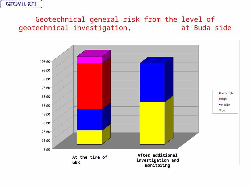
Geotechnical general risk from the level of geotechnical investigation, at Buda side
At the time of GBR After additional investigation and monitoring
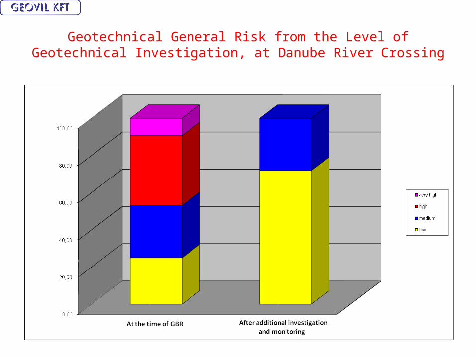
Geotechnical General Risk from the Level of Geotechnical Investigation, at Danube River Crossing

Geotechnical General Risk from the Level of Geotechnical Investigation at Pest side
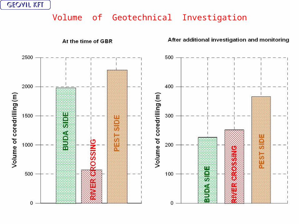
Volume of Geotechnical Investigation
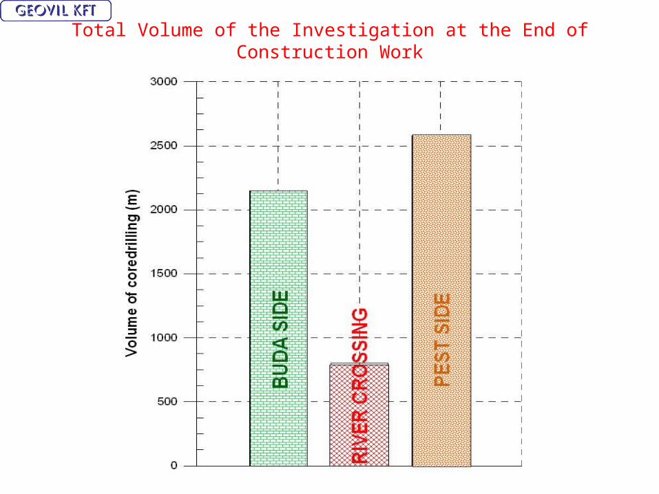
Total Volume of the Investigation at the End of Construction Work
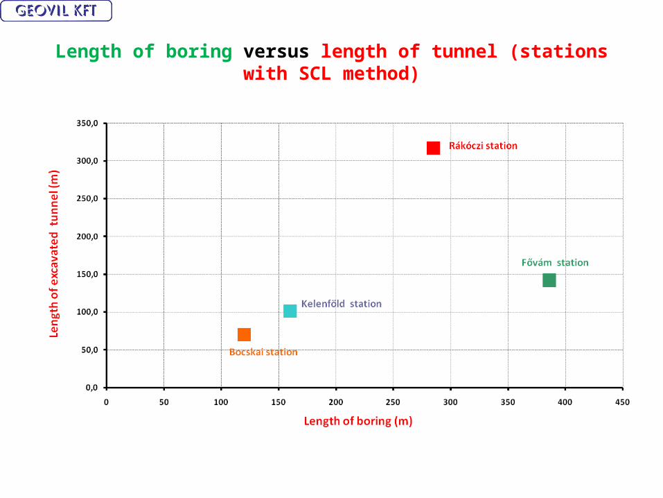
Length of boring versus length of tunnel (stations with SCL method)
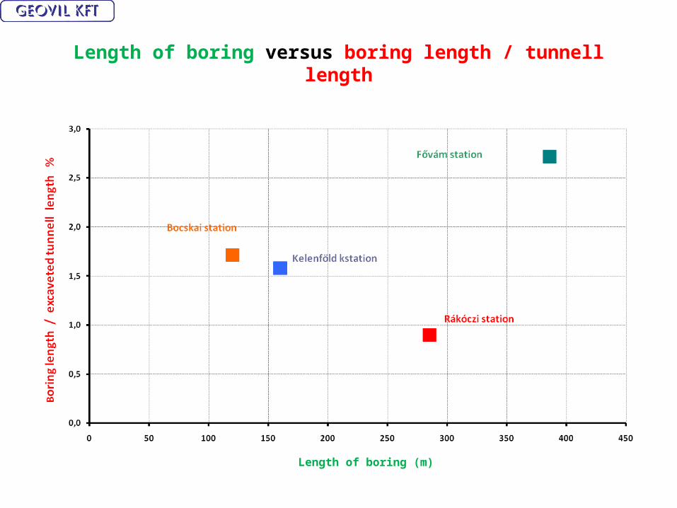
Length of boring versus boring length / tunnell length
Length of boring (m)

Length of boring versus length of tunnell
Recommended rate of USTNC/TT=1,2 *
* U.S. National Committe on Tunnelling Technology, 2005

Cost of geotechnical investigation / cost construction at SCL tunnells
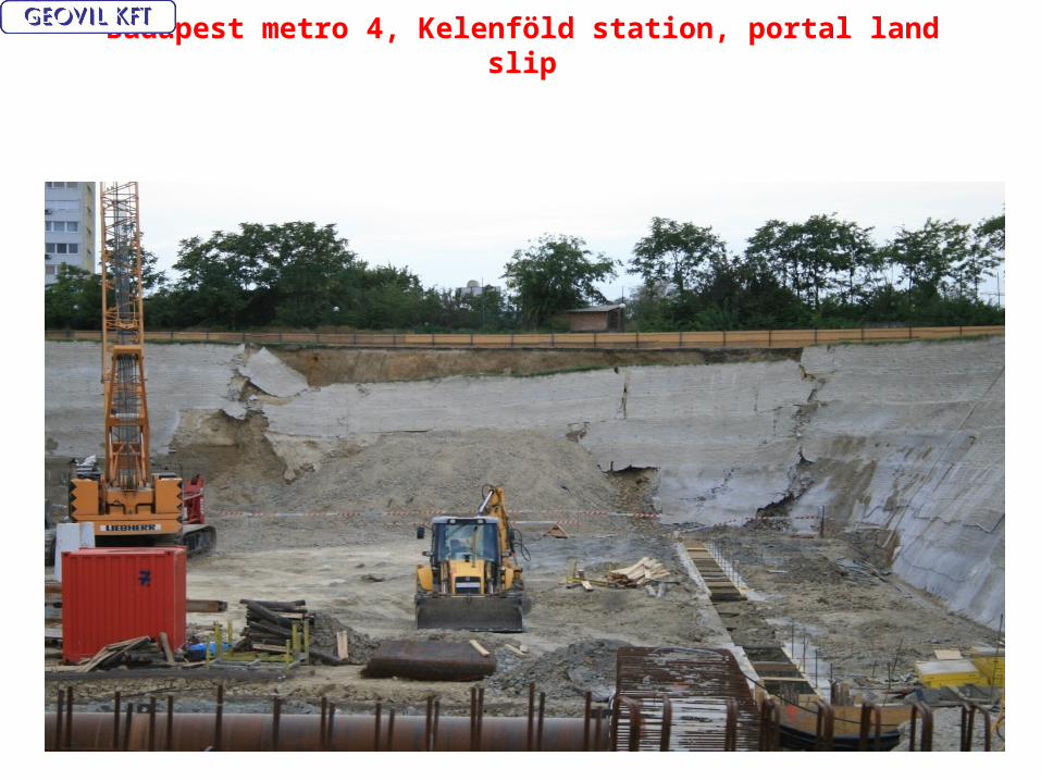
Budapest metro 4, Kelenföld station, portal land slip
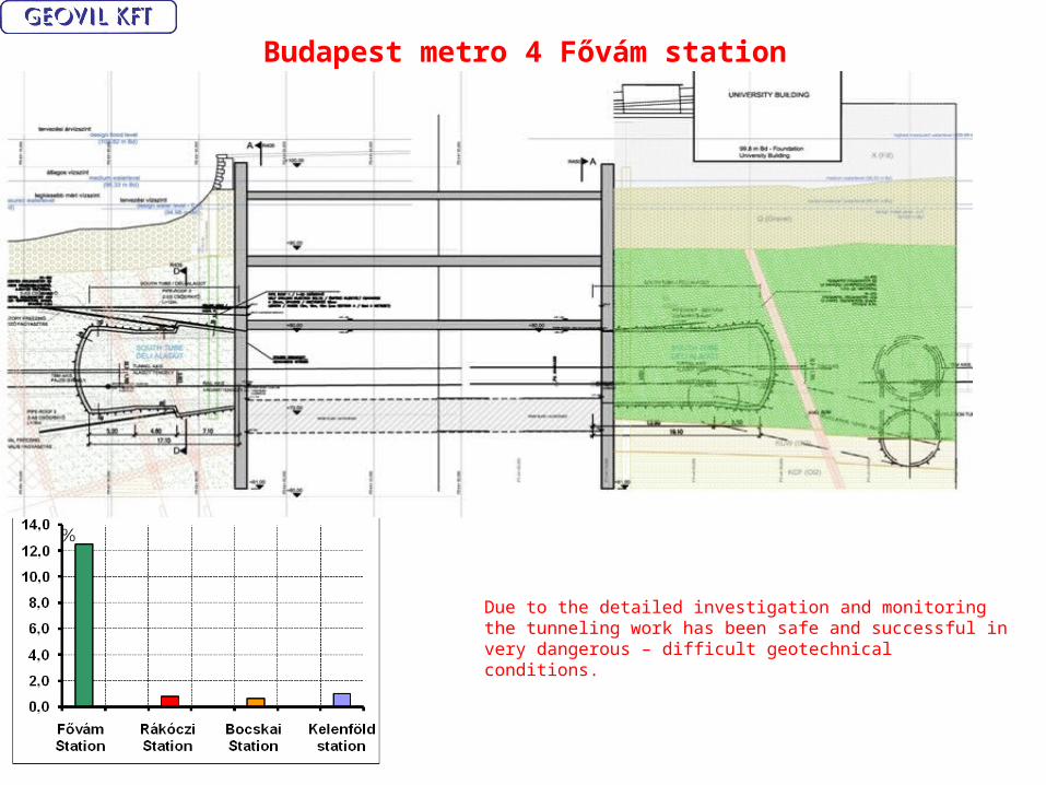
Budapest metro 4 Fővám station
Due to the detailed investigation and monitoring the tunneling work has been safe and successful in very dangerous – difficult geotechnical conditions.

Budapest metro 4 Rákóczi station SCL tunnell collapse – wash out
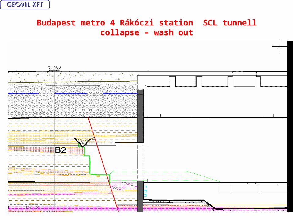
Budapest metro 4 Rákóczi station SCL tunnell collapse – wash out
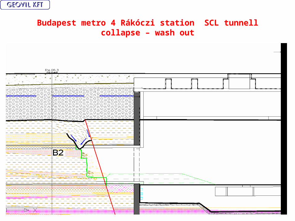
Budapest metro 4 Rákóczi station SCL tunnell collapse – wash out

Budapest metro 4 Rákóczi station SCL tunnell collapse – wash out

Budapest metro 4 Rákóczi station SCL tunnel collapse – wash out
Conclusions and recommendations
• The Geotechnical Risk Assessment comes from a suitable site investigation and the consequent building of an appropriate and coherent Engineering Geological model.
• It is desirable to create an international standard for the Geotechnical Risk Assessment, and to agree the parameters and guidelines for these recommendations.
• The Geotechnical Risk Assessment has a relationship to the quantity of meters of site investigation holes bored and the excavated length of tunnel. For the SCL tunnel ( soft tunneling at shallow depth ) the ratio of site investigation / excavated tunnel length should be 1.2 .
• For the Budapest metro 4 project, the recommended ratio was followed. This resulted in a project which was very safe, in geological, geotechnical terms also the project had very few disputes related to the geotechnical risk clauses

Thank you for your kind attention!