Embed Size (px)
Citation preview

Geotechnical damage in rural areas caused by the 2015 Gorkha Nepal Earthquake
Chiaro GabrieleJSPS RESEARCH FELLOW, University of TokyoLecturer, University of Canterbury, New Zealand
Kiyota T., Pokhrel R.M., Katagiri T.Institute of Industrial Science, University of TokyoGoda K.University of Bristol, United KingdomSharma K.University of Alberta, Canada
Tokyo, 1 June 2015

Outline:1. Damage survey
2. Tectonics of Nepal
3. Geotechnical damage (rural areas)3.1 Trishuli area3.2 Melamchi area3.3 Epicentral area (Baluwa)3.4 Pokhara Valley
4. Summary
5. Recommendations3

Advanced Party of Japanese Investigation Team for the 2015 Nepal Earthquake Disaster
JGS: Japanese Geotechnical SocietyJSCE: Japanese Society of Civil Engineers
ATC3, ISSMGE: Asian Technical Committee, Int. Society of Soil Mech. & Geotech. Eng.
Figure 1. Survey team: Kiyota Takashi; Katagiri Toshihiko; Pokhrel Pradeep; Pokhrel Rama Mohan; Chiaro Gabriele; and Goda Katsuichiro (from left to right) 2

1. Damage survey • Day 1 (5/1): Kathmandu (city center)• Day 2 (5/2): Trishuli and Melamchi• Day 3 (5/3): Kathmandu (suburbs)• Day 4 (5/4): Baluwa (Epicentral area)• Day 5-6 (5-6/5): Pokhara Valley• Day 7 (5/7): Briefing Kathmandu
0 25 50 km
Pokhara
Trishuli
Melamchi
Kathmandu
Baluwa
Mw6.7
Mw7.3
Mw6.6
Mw7.8VII
VIIIVI
Figure 2. Survey routes and location of investigation sites 3
2. Tectonics of Nepal
HimalayaTibetan Plateau
MBT
MFT MCT
NEPAL
Figure 3. Schematic illustration showing the relative motion and main features associated with the type of plate boundaries in Nepal (mod. after Sapkota et al., 2013)
MCT: Main Central Thrust MBT: Main Boundary ThrustMFT: Main Frontal Thrust
5

3. Geotechnical damage in rural areas
Figure 4. Typical village in mountainous areas of central Nepal6

3.1 Trishuli areaNorthwest of
Kathmandu City
0 5 10 km
Trishuli Gerkhu
Ranipauwa
Battar
Nigala
Kathmandu City
Photo 1,2
Photo 3,4
Photo 6-14 Photo 5
Figure 5. Survey routes and location of investigation sites along Trishuli Highway
50 km southeast of the Mw7.8 (4/25)
epicenter
7

Shallow landslide on steep slope
0.01 0.1 1 100
20
40
60
80
100
Perce
ntage
finer
by w
eigth:
%
Particle size: mm
Ranipauwa sand
D50=0.21
Weathered sedimentary rocks
Figure 6. (a) shallow landslide occurred near Ranipauwa; and (b) gradation of sand sample
(b)
(a)
1
8
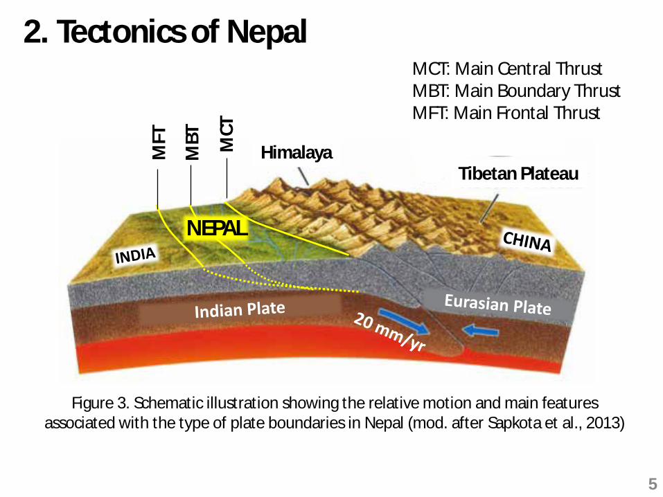
Damage to the Trishuli Highway
Steep slope
Figure 7. Cracks and fissures on the roadway triggered by the earthquake
Rain water and/or aftershockscan cause slope failure
2
9
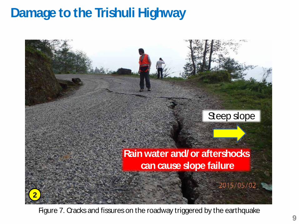
Rock fall along the Trishuli Highway
Cracks on the road
Figure 8. A bus impacted by falling rocks near Nigala village
Need for protectionsystems !!!
3
4
10

Damage to the Trishuli earth dam
Hydropower plant damaged
earth dam
Figure 9. A view of the reservoir and earth fill dam as seen from Gerkhu village
Dam Length: 1150mDam Height: 12m upstream side
20m downstream sideCrest width: 4 m
5
11

crest
earth fill dam12
Figure 10. (a) a view of the reservoir as seen from the upstream side; and (b) cracking at the upstream side
(a)
(b)
6
7
12

Figure 11. (a) schematic cross-section of Trishuli dam; (b) ground settlement at the upstream side; (c) cracking on the crest; and (d) no apparent damage at the downstream side
Compacted gravelly/silty soil
reservoir
?
Upstream side
Downstream side
Crest
Need investigations to verify dam body is not damaged
(a)
(b) (c)
(d)
89
10
13

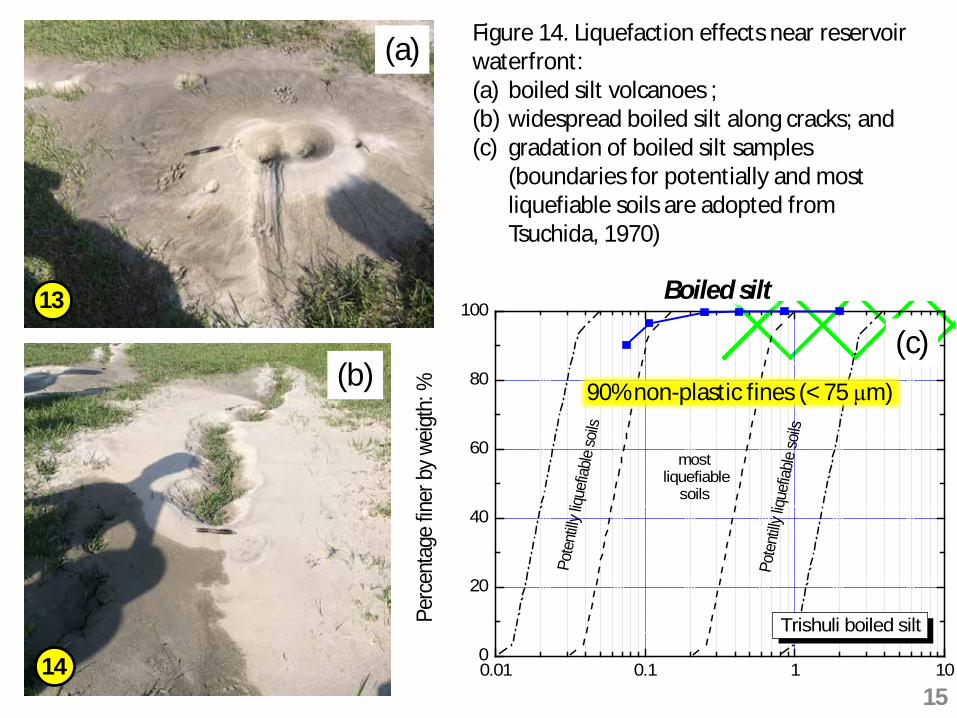
Soil liquefaction
Figure 12. Location of liquefied area at the reservoir waterfront
Figure 13. Cracking and lateral spreading of gently sloped ground
Max. distancefrom waterfront : 29m
Max. length: 52 mMax. opening: 60 cm
11
12
14
29 m
52 m
0.01 0.1 1 100
20
40
60
80
100
Perc
enta
ge fin
er b
y weig
th: %
Particle size: mm
Pote
ntilly
lique
fiable
soils
most liquefiable
soils
Pote
ntilly
lique
fiable
soils
Trishuli boiled silt
Figure 14. Liquefaction effects near reservoir waterfront: (a) boiled silt volcanoes ; (b) widespread boiled silt along cracks; and (c) gradation of boiled silt samples
(boundaries for potentially and most liquefiable soils are adopted from Tsuchida, 1970)
90% non-plastic fines (< 75 μm)
(a)
(c)(b)
Boiled silt13
1415

3.2 Melamchi areaTrishuli
Bahunipati
Melamchi
Kathmandu City
Photo 15
Photo 20
0 5 10 km
Northeast of Kathmandu City Photo 16,17
• 90 km from Mw7.8 (4/25)• 40 km from Mw6.7 (4/26)
Figure 15. Survey route and location of site investigations in Melamchi area
16

Retaining wall failure
Figure 16. Cracking on the roadway induced by retaining wall failure
Need stabilization work to avoid wall collapse
Sliding of the wall and settlement of the backfill
15
17

Ready-to-fall boulders
Figure 17. (a) shallow landslide near Melamchi town ; and (b) unstable boulders threatening houses and road
Shallow landslide and unstable rocks
16
17
(a) (b)
18
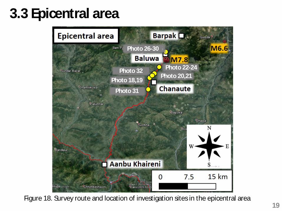
3.3 Epicentral area
Figure 18. Survey route and location of investigation sites in the epicentral area
Photo 31
Photo 18,19Photo 32
Photo 20,21Photo 22-24
Photo 26-30
19

Artificial slope
Figure 19. (a) Artificial slope survived earthquake; and (b) cracking on the slope
(a)
Expected collapse during rainy season
18
19
(b)
20
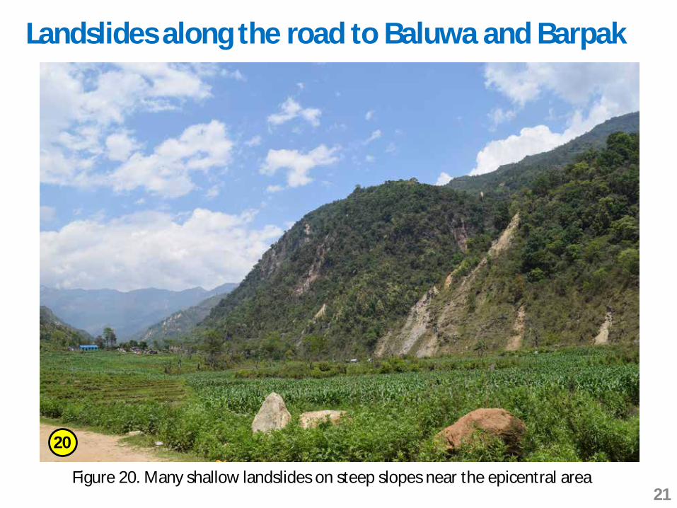
Landslides along the road to Baluwa and Barpak
Figure 20. Many shallow landslides on steep slopes near the epicentral area
20
21
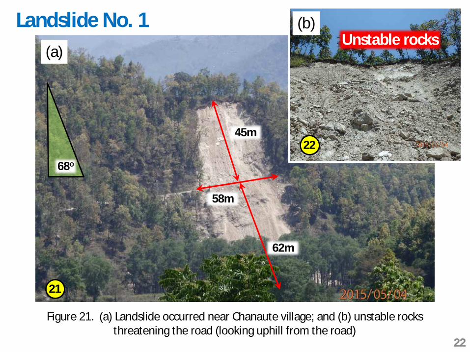
Landslide No. 1
45m
Figure 21. (a) Landslide occurred near Chanaute village; and (b) unstable rocks threatening the road (looking uphill from the road)
58m
62m
21
22
68o
(a)
(b)Unstable rocks
22

71m
38m
Landslide No. 2
22
(a)
(b)
(c)
23
24
Figure 22. (a) Collapsed hill blocking the road; (b) large size boulders; and (c) limestone rock fragment
Limestone
23
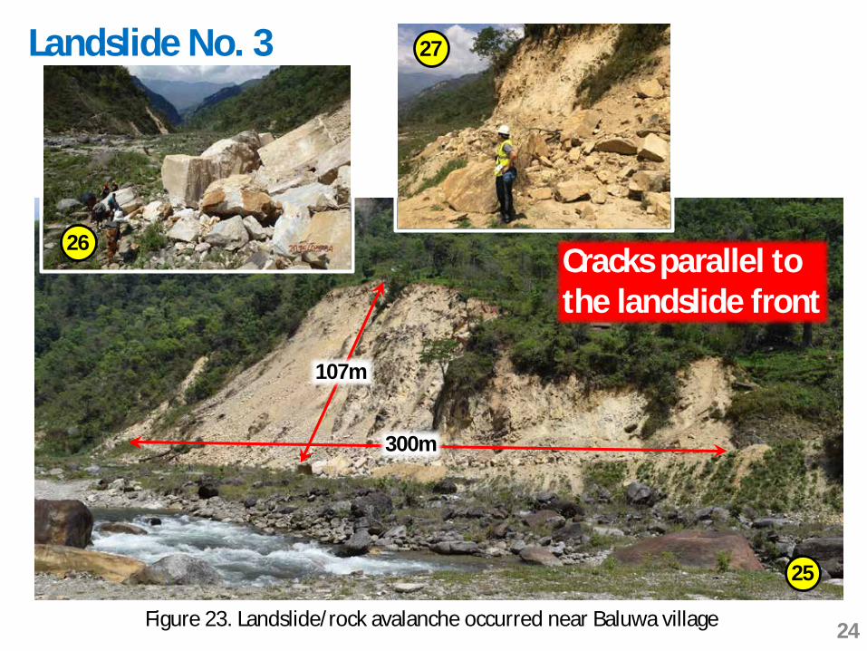
107m
300m
Landslide No. 3
Figure 23. Landslide/rock avalanche occurred near Baluwa village
25
Cracks parallel to the landslide front
26
27
24
29
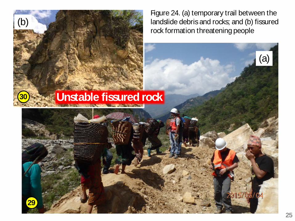
Figure 24. (a) temporary trail between the landslide debris and rocks; and (b) fissured rock formation threatening people
30 Unstable fissured rock
(a)
(b)
25

32Figure 26. Large-size rock fall
nearby Chanaute
30 Unstable cracked rock
(a)
31
Figure 25. Rock fall and temporary cleared road
Weathered rock
Rock block failure
Rock fall along the main road
More rock falls are anticipated during
rainy season/aftershoks
26
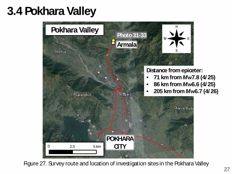
3.4 Pokhara ValleyPokhara Valley
0 2.5 5 km
POKHARACITY
ArmalaPhoto 31-33
Distance from epiceter:• 71 km from Mw7.8 (4/25)• 86 km from Mw6.6 (4/25)• 205 km from Mw6.7 (4/26)
Figure 27. Survey route and location of investigation sites in the Pokhara Valley27
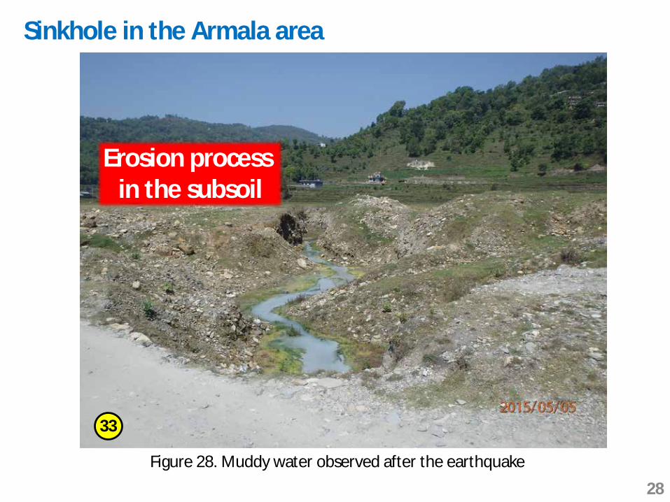
Sinkhole in the Armala area
Figure 28. Muddy water observed after the earthquake
33
Erosion process in the subsoil
28

No new sinkholes and no change in size of existing sinkholes
Nov 2014
May 2015
34
35
Figure 29. A typical sinkhole in the Armala area
Possible sinkhole formationduring rainy season
29

4. SummaryThe post-earthquake damage survey conducted fromMay 1 to 6 can be summarized as follows:
Trishuli area:• A number of landslides and rock falls occurred and
cracking of the road were often observed
• Silt boiling and lateral spreading of a gentle slopewere the evidence of liquefaction occurrence
• Damage to an earth fill dam was observed.However, fissures appeared along the dam axis andno water leakage was reported
30

Melamchi area:A number of landslides were triggered not only by themainshock but also by a major Mw6.7 aftershock thatoccurred 40 km northeast of Melamchi
Epicentral area:Landslides and rock falls occurred in many locations.One of the large landslides blocked the road betweenBaluwa village and Barpak village making it difficult forrescue teams to quickly reach affected disaster area
Pokhara Valley:In the Armala area, while sinkhole formation has beenin progress since November 2013, no new sinkholeswere formed by the earthquake
31

The following recommendations are given by theAuthors:
• Inspection of the landslide and rock fall areas iscrucial because cracked and unstable rocks still remainon the slope. Surviving slopes may experience furtherdamage during aftershocks and/or rainy season
• Cracking at the upstream side and on the crest ofTrishuli earth fill dam suggests deterioration of thedam body, which may be accelerated to failure of thedam. Therefore, rehabilitation works are required forthe dam as early as possible after conductingdetailed investigations
5. Recommendations
32

• In the mountainous area, formation of naturallandslide dams was reported. They should besurveyed in order to evaluate possible breaching
33

Full details of survey damage are reported in
Chiaro, G., Kiyota, T., Pokhrel, R.M., Goda, K., Katagiri, T. andSharma, K. (2015). Quick report on damage survey of the 25 April2015, Gorkha Earthquake, Nepal. Soils and Foundations, in review.
Goda, K., Kiyota, T., Pokhrel, R.M., Chiaro, G., Katagiri, T., Sharna, K.and Wilkinson, S. (2015). The 2015 Gorkha Nepal Earthquake:insights from earthquake damage survey. Frontiers in BuiltEnvironment (Earthquake Engineering), in review.
34

Thank you very much for your kind attention!
AcknowledgementsMr. Pokhrel P. (Tribhuvan University, Nepal)Mr.Kato, Y. (NHK)Mr. Hirano, M. and Mr. Kaneko, J. (The Mainichi Newspapers)
35