Embed Size (px)
Citation preview
GEOSPATIAL TECHNOLOGY INNOVATIONS FOR LAND TENURE
SECURITY IN EAST AFRICA - GETTING NEEDS
Ine Buntinx1, Serene Ho2, Joep Crompvoets3, Bruno Broucker4, Valérie Pattyn5
1,2,3,4KU Leuven, Leuven, Belgium
5Leiden University, Netherlands
[email protected], [email protected], [email protected], [email protected], [email protected]
Abstract
Sub-Saharan Africa has an immense challenge to rapidly and cheaply map millions of
unrecognized land rights. Current recording and mapping approaches did not succeed to
meet the promising expectations: disputes abound, investment is impeded, and the
community’s poorest lose out. In order to cope with these challenges a research project
called ‘its4land’ is carried out. Its4land is a European Commission Horizon 2020 project
aiming to develop an innovative suite of land tenure recording tools for three East
African countries (Ethiopia, Kenya, Rwanda). These land tenure tools are inspired by
geo-information technologies, including smart sketchmaps, UAV’s, automated feature
extraction and geocloud services. For each African country two specific case locations
are selected. The six case locations are Bahir Dar city (Ethiopia), Robit Bata rural Kebele
(Ethiopia), Kisumu County (Kenya), Kajiado County (Kenya), Musanze City (Rwanda) and
Busogo (Rwanda). In order to reach this overarching research goal, a fundamental first
step is to “get needs”, i.e. capture the specific needs, readiness, market opportunities of
end-users in the domain of land tenure information recording. Therefore, this paper
aims to elaborate the research design responding to these fundamentel first step. This
includes actor and case-specificic data collection and other methods like Actor Network
Theory, Multi-Actor Multi-Criteria Analysis and Market Gap Analysis. An integrated
design is also proposed to facilitate a coordinated approach to the complicated data
collection and analysis requirements. This way, the diverse nature of the actors of
interest with regards to readiness and potential impact on the project is taken into
account.
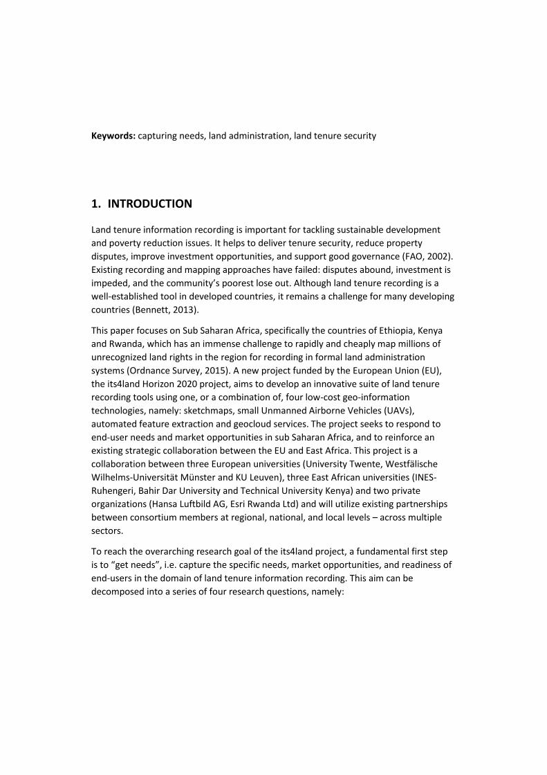
Keywords: capturing needs, land administration, land tenure security
1. INTRODUCTION
Land tenure information recording is important for tackling sustainable development
and poverty reduction issues. It helps to deliver tenure security, reduce property
disputes, improve investment opportunities, and support good governance (FAO, 2002).
Existing recording and mapping approaches have failed: disputes abound, investment is
impeded, and the community’s poorest lose out. Although land tenure recording is a
well-established tool in developed countries, it remains a challenge for many developing
countries (Bennett, 2013).
This paper focuses on Sub Saharan Africa, specifically the countries of Ethiopia, Kenya
and Rwanda, which has an immense challenge to rapidly and cheaply map millions of
unrecognized land rights in the region for recording in formal land administration
systems (Ordnance Survey, 2015). A new project funded by the European Union (EU),
the its4land Horizon 2020 project, aims to develop an innovative suite of land tenure
recording tools using one, or a combination of, four low-cost geo-information
technologies, namely: sketchmaps, small Unmanned Airborne Vehicles (UAVs),
automated feature extraction and geocloud services. The project seeks to respond to
end-user needs and market opportunities in sub Saharan Africa, and to reinforce an
existing strategic collaboration between the EU and East Africa. This project is a
collaboration between three European universities (University Twente, Westfälische
Wilhelms-Universität Münster and KU Leuven), three East African universities (INES-
Ruhengeri, Bahir Dar University and Technical University Kenya) and two private
organizations (Hansa Luftbild AG, Esri Rwanda Ltd) and will utilize existing partnerships
between consortium members at regional, national, and local levels – across multiple
sectors.
To reach the overarching research goal of the its4land project, a fundamental first step
is to “get needs”, i.e. capture the specific needs, market opportunities, and readiness of
end-users in the domain of land tenure information recording. This aim can be
decomposed into a series of four research questions, namely:
R1. What are stakeholders’ needs relevant to land tenure information recordation, and
how do these affect other stakeholders’ needs along the land tenure information
value system?
R2. How might the proposed geospatial technologies meet stakeholders’ land tenure
information recordation needs?
R3. Where the proposed technologies can better support stakeholders’ needs, how
ready are stakeholders to adopt these new technologies?
R4. What are the potential market opportunities associated with: 1) the introduction
and adoption of these new technologies; and 2) more current and complete land
tenure information?
The aim of this paper is to elaborate the research design for responding to these
research questions. The structure of the paper is as follows: first the different case
locations and their specific settings are summarized. This is followed by an in-depth
explanation of the proposed research design and methods and how these will be
integrated and applied in the case studies. The paper concludes with a short summary of
the major findings and intentions regarding the research design.
2. ETHIOPIA, KENYA AND RWANDA IN PERSPECTIVE
The measurement of the needs, readiness and market opportunities will take place in
the three different countries and the selected case study areas. For all three sub-
Saharan African countries two specific case locations are selected. Taken together, the
case studies are intended to illustrate the range of typical land tenure recording
situations across most of sub Saharan Africa; however, the final choices are also
determined by a range of criteria including:
project relevance – allowance to develop a suite of land tenure recording tools that
responds to the end-user needs and market opportunities in Sub Saharan Africa
applicability of the geospatial technologies (sketchmaps, uav, automated feature
extraction)
accessibility – areas should not be located in too remote places (i.e. no more than
1.5 days drive from a capital city)
availability of key spatial datasets, such as orthophotos, land cover/use maps
safety – unsafe areas are avoided
size – not too large as the research has to be manageable.
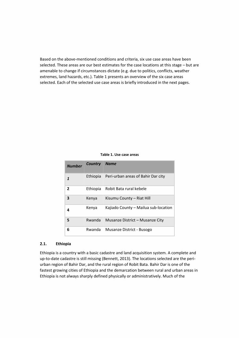
Based on the above-mentioned conditions and criteria, six use case areas have been
selected. These areas are our best estimates for the case locations at this stage – but are
amenable to change if circumstances dictate (e.g. due to politics, conflicts, weather
extremes, land hazards, etc.). Table 1 presents an overview of the six case areas
selected. Each of the selected use case areas is briefly introduced in the next pages.
Table 1. Use case areas
Number Country Name
1 Ethiopia Peri-urban areas of Bahir Dar city
2 Ethiopia Robit Bata rural kebele
3 Kenya Kisumu County – Riat Hill
4 Kenya Kajiado County – Mailua sub-location
5 Rwanda Musanze District – Musanze City
6 Rwanda Musanze District - Busogo
2.1. Ethiopia
Ethiopia is a country with a basic cadastre and land acquisition system. A complete and
up-to-date cadastre is still missing (Bennett, 2013). The locations selected are the peri-
urban region of Bahir Dar, and the rural region of Robit Bata. Bahir Dar is one of the
fastest growing cities of Ethiopia and the demarcation between rural and urban areas in
Ethiopia is not always sharply defined physically or administratively. Much of the
contemporary growth, where high levels of human-to-land interactions exist, is clearly
taking place in peri-urban areas in all directions of the city. The urban administration
considers this part of the city as part of rural land administration and proclamation,
whereas, the rural administration considers it as part of urban administration and policy.
In this context, these areas can be described as institutional ‘vacuum’ zones. Because of
this, land administration problems such as the high level of informality and land tenure
insecurity appear to be enduring problems and present ongoing challenges for
sustainable urban development (Adam, 2014).
Robit Bata kebele is a rural area, which is facing land degradation and fragmentation problems (Binggeli and Desissa, 2003). In order to tackle these problems, land tenure information is vital as input information for land consolidation purposes. Recent orthophotos are available to be used for land certification. Other strengths of this selected kebele are that it is topographically rather undulating and rural.
2.2. Kenya
The national cadastre in Kenya is largely incomplete and can be described as a
patchwork of isolated and inconsistent cadastres (Siriba and Mulaku, 2011). The
selected locations, Kisumu and Kajiado, have different problems regarding land
administration. Kisumu is facing a rapid conversion from rural to urban area. The main
problem here is that rural general boundaries cannot be maintained and secondly, the
properties are increasing in value and are now in need of better boundary descriptions.
On the other hand, Kajiado County is still dominated by nomadic pastoralism. The land
tenure system is characterized by group ranches without adequate survey control and
without proper land use planning. In the process of subdividing and registering private
land, pastoralists’ migration routes and their needs to access important resources such
as water points are often overlooked. In the meantime, pastoralists continue to practice
open range grazing and moving from place to place in search of pastures and water,
based on their traditional animal husbandry practices. Therefore, the area is
experiencing increased conflicts between nomadic pastoralism with communal grazing
areas and private property regimes like crop farmers and investors in search for land for
settlement, agriculture or tourism industry. Therefore, conflicts between pastoralists
and crop farmers and pastoralism and the tourism industry are common in the area
(Bennett, 2013).
2.3. Rwanda
Unlike Ethiopia and Kenya, Rwanda does not have a long land administration or national
cadastre history. Nevertheless, the efforts of the past decade paid off. The results and
prospects look very promising in terms of the implementation of a complete cadastre
system. However, the current system is not yet adapted to upcoming sustainable
development and land use challenges (Bennett, 2013). These problems will be
investigated in the Musanze district, which is subdivided into 15 sectors, among which
three are urban (Muhoza, Musanze and Cyuve). Despite the high population density,
Musanze district is predominantly rural with rather small parcel sizes. As such, Musanze
District is an excellent use case area to study the suitability of the suite of land tenure
recording tools for urban and rural smallholders.
Musanze city is one of the six secondary cities of the country (after Kigali City, the capital
of Rwanda) developed to support Kigali to alleviate and decentralise stress from people
looking for jobs and a better quality of life. After the land tenure regulation program was
completed in 2013, some sectors became urbanized at a rapid pace. Busogo sector is
located approximately 10 kilometres west of Musanze City and is more rural. The rural
areas are made of small plots with very fertile soils because of the volcanoes
surrounding them but a large part of the agricultural land and forest are being
transformed into built up areas. Both locations are located south of the Volcanoes
National Park, safe and easily accessible.
In summary, the Ethiopian cases focus on peri-urban and rural land certification, the
Kenyan cases address pastoralist land rights registration in the context of subdividing
group ranches into private holdings – and associated land disputes with other land uses,
and the Rwandese cases focus on urban and rural smallholders’ registration.
3. METHODOLOGY
To respond to the research questions, the following methodologies are proposed:
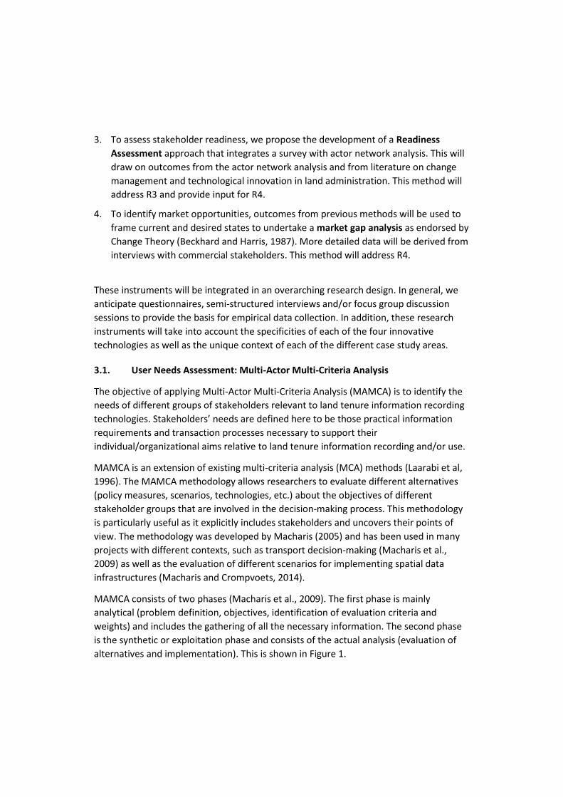
1. To capture stakeholders’ needs, we propose the use of the Multi-Actor Multi-
Criteria Approach – MAMCA (Macharis, 2005). This method will address R1 as well
as R2 and will provide input into other research questions.
2. To understand and map the current state and interactions of stakeholders along the
land tenure information value chain, we propose the use of Social Network
Analysis. The use of this method and its outcomes will feed into all research
questions R1-4.
3. To assess stakeholder readiness, we propose the development of a Readiness
Assessment approach that integrates a survey with actor network analysis. This will
draw on outcomes from the actor network analysis and from literature on change
management and technological innovation in land administration. This method will
address R3 and provide input for R4.
4. To identify market opportunities, outcomes from previous methods will be used to
frame current and desired states to undertake a market gap analysis as endorsed by
Change Theory (Beckhard and Harris, 1987). More detailed data will be derived from
interviews with commercial stakeholders. This method will address R4.
These instruments will be integrated in an overarching research design. In general, we
anticipate questionnaires, semi-structured interviews and/or focus group discussion
sessions to provide the basis for empirical data collection. In addition, these research
instruments will take into account the specificities of each of the four innovative
technologies as well as the unique context of each of the different case study areas.
3.1. User Needs Assessment: Multi-Actor Multi-Criteria Analysis
The objective of applying Multi-Actor Multi-Criteria Analysis (MAMCA) is to identify the
needs of different groups of stakeholders relevant to land tenure information recording
technologies. Stakeholders’ needs are defined here to be those practical information
requirements and transaction processes necessary to support their
individual/organizational aims relative to land tenure information recording and/or use.
MAMCA is an extension of existing multi-criteria analysis (MCA) methods (Laarabi et al,
1996). The MAMCA methodology allows researchers to evaluate different alternatives
(policy measures, scenarios, technologies, etc.) about the objectives of different
stakeholder groups that are involved in the decision-making process. This methodology
is particularly useful as it explicitly includes stakeholders and uncovers their points of
view. The methodology was developed by Macharis (2005) and has been used in many
projects with different contexts, such as transport decision-making (Macharis et al.,
2009) as well as the evaluation of different scenarios for implementing spatial data
infrastructures (Macharis and Crompvoets, 2014).
MAMCA consists of two phases (Macharis et al., 2009). The first phase is mainly
analytical (problem definition, objectives, identification of evaluation criteria and
weights) and includes the gathering of all the necessary information. The second phase
is the synthetic or exploitation phase and consists of the actual analysis (evaluation of
alternatives and implementation). This is shown in Figure 1.
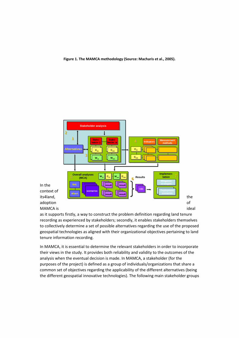
Figure 1. The MAMCA methodology (Source: Macharis et al., 2005).
In the
context of
its4land, the
adoption of
MAMCA is ideal
as it supports firstly, a way to construct the problem definition regarding land tenure
recording as experienced by stakeholders; secondly, it enables stakeholders themselves
to collectively determine a set of possible alternatives regarding the use of the proposed
geospatial technologies as aligned with their organizational objectives pertaining to land
tenure information recording.
In MAMCA, it is essential to determine the relevant stakeholders in order to incorporate
their views in the study. It provides both reliability and validity to the outcomes of the
analysis when the eventual decision is made. In MAMCA, a stakeholder (for the
purposes of the project) is defined as a group of individuals/organizations that share a
common set of objectives regarding the applicability of the different alternatives (being
the different geospatial innovative technologies). The following main stakeholder groups
Stakeholder analysisStakeholder analysis
Stake-
holder 1
Stake-
holder 1
C11C11 CCAlternativesAlternatives
Cn1Cn1 Cnm
Cnm
Stake-
holder m
Stake-
holder m
Ref.Ref.
AlternAltern
C11C11 Results
Implemen-
tation
Implemen-
tation
scenariosscenarios
resultresult
resultresult
CnmCnm
resultresult
resultresult
IndicatorsIndicators Measurementmethods
Measurement
methods
C11C11
CnmCnm
Mitigation
strategies
Mitigation
strategies
C11C11 CC
Wn1Wn1 Wnm
Wnm
W11W11 Wnm
Wnm
Overall analyses
(MCA)
+/0/-+/0/-Deployment
scenarios
Deployment
scenarios
11
22
6655
44
33
77
were defined: Public Sector entities, non-statutory entities, Private Sector entities,
NGOs/Not-for-Profit / Donors / Development partners, and Research & Development
entities. From these stakeholders groups a set of relevant stakeholders and
representatives will be determined, likely by experts. The final definition of the
objectives of the stakeholders will likely be an iterative process with multiple reviews
and adaptations due to frequent contact with the stakeholders themselves and
meetings with experts in the field of land tenure recording. The key stakeholders will be
determined based on their relevance and common objectives.
The objectives are then translated into criteria for each stakeholder (step 3), which need
to be weighted. Different strategies are valid when determining these criteria. In this
study, a combination of different approaches are used to inductively and deductively
determine a specific set of criteria per stakeholder group as well as their respective
weights. These include in-depth interviews with key representatives of each stakeholder
group as well as literature review. The resulting preliminary list is then validated by a
number of experts in land tenure recording in each specific country and/or use case
area, such as land registration/administration offices, etc. The feedback of these players
result in a final set of criteria per stakeholder. Weights (between 0 and 1) will be
assigned to these criteria by different members of each stakeholder group by using the
Analytical Hierarchy Process (AHP) method (Saaty, 1988). This MCA technique uses
pairwise comparisons to generate a ranking of the different criteria. Each criterion is
evaluated with regard to the others by using a 1–9 comparison scale. From each
stakeholder group, a to-be-determined number of representatives will evaluate ‘their’
set of criteria about the stakeholder group’s objectives. Based on the 9-point scale, the
AHP method uses eigenvectors and eigenvalues to determine the weight of each
criterion (Saaty, 1980; 1988).
In the fourth step, one or more relevant measurable indicators are formulated and
linked to each criterion partly based on a literature study. They allow evaluating the
performance of each alternative with regards to a given criterion and are either
quantitative or qualitative, depending on the criterion.
The fifth step aggregates all the information from the previous steps into an evaluation
matrix. Like the weight assignation in step 3, the AHP method is used to obtain the final
ranking. These pairwise comparisons are compiled in a matrix using the 1–9 scale by
Saaty (1988) and this aggregation needs strong support of experts and stakeholders to
argue the pairwise comparisons.
The scoring results of each alternative and each stakeholder group are calculated in step
6. They are generated through MCA using the weights of the criteria obtained in step 2
and the pairwise comparisons of step 5. The strengths and weakness of each alternative
for each stakeholder group is visualized in a graph chart. At this stage, a sensitivity
analysis, exploring the effects of a change of the weights on the ranking, can be
performed.
3.2. Readiness Assessment: Actor Network Analysis
The successful and sustainable adoption of the geospatial technologies in the different
case countries will be determined by stakeholders’ readiness for innovation. The
intention is to develop a readiness assessment tool for innovation in land information
recordation. For each of the case area, a quantitative and qualitative description of
readiness to adopt innovative land tenure recordation tools will be established.
Of the multiple possible approaches to assess readiness, a holistic conceptualization is
used. A working definition of readiness proposed for this project is: readiness involves
both social (cultural, organisational and regulatory) as well as technical abilities and
capacities for the adoption of innovative land information recordation tools. In contrast
to e.g. the e-government or ICT literature, where a plurality of readiness assessment
tools circulates (Alaaraj and Ibrahim, 2014), no such measurement instrument is readily
available for the adoption of land information recordation tools in developing countries.
Therefore, the following activities will be undertaken. Although analytically
distinguished, most activities will run in parallel.
3.2.1. Identifying the network of actors in a particular case site.
An important prerequisite for the actual readiness assessment is to identify the network
of actors that have a stake in land recordation in a particular case site. The concept of a
network is useful to reflect the dynamic and heterogeneous interactions between many
parties (Vancauwenberghe et al., 2011). A land information recordation network
captures the organizations that are involved in land recordation, or that will be involved
in the implementation of one of the geospatial tools. In addition, it captures the flows
and nature of the interaction that exist between these stakeholders and tools.
Latour’s (2005) Actor Network Theory (ANT) is an approach used to support
understanding of stakeholders’ interactions with others and their spheres of influence. A
major strength of this method is that the analysed network does not merely consider
people and organizations, but also non-human participants like geospatial tools.
Furthermore, the interactions and relations between the different actors are clearly
visualized. ANT will facilitate an actor network analysis (ANA) for each case location.
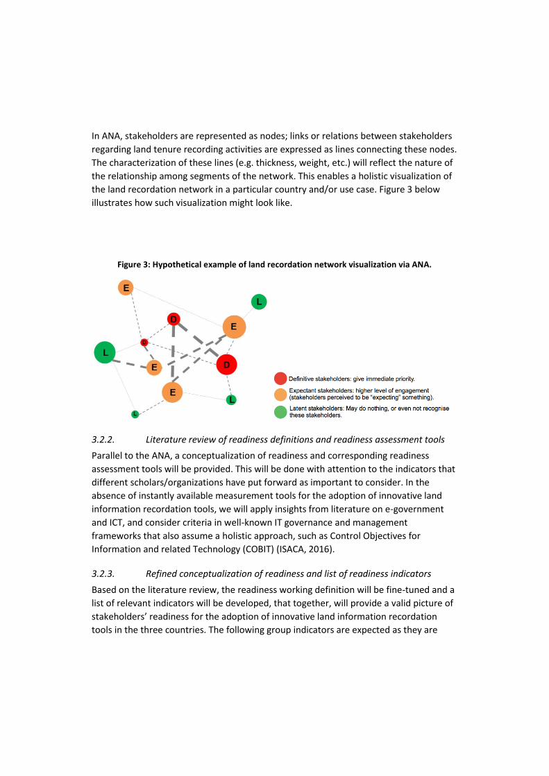
In ANA, stakeholders are represented as nodes; links or relations between stakeholders
regarding land tenure recording activities are expressed as lines connecting these nodes.
The characterization of these lines (e.g. thickness, weight, etc.) will reflect the nature of
the relationship among segments of the network. This enables a holistic visualization of
the land recordation network in a particular country and/or use case. Figure 3 below
illustrates how such visualization might look like.
Figure 3: Hypothetical example of land recordation network visualization via ANA.
3.2.2. Literature review of readiness definitions and readiness assessment tools
Parallel to the ANA, a conceptualization of readiness and corresponding readiness
assessment tools will be provided. This will be done with attention to the indicators that
different scholars/organizations have put forward as important to consider. In the
absence of instantly available measurement tools for the adoption of innovative land
information recordation tools, we will apply insights from literature on e-government
and ICT, and consider criteria in well-known IT governance and management
frameworks that also assume a holistic approach, such as Control Objectives for
Information and related Technology (COBIT) (ISACA, 2016).
3.2.3. Refined conceptualization of readiness and list of readiness indicators
Based on the literature review, the readiness working definition will be fine-tuned and a
list of relevant indicators will be developed, that together, will provide a valid picture of
stakeholders’ readiness for the adoption of innovative land information recordation
tools in the three countries. The following group indicators are expected as they are
either present in most readiness assessment frameworks (Alaaraj and Fatimah, 2014), or
in reviews of challenges to ICT and e-government in developing countries (e.g. Gil-Garcia
and Pardo, 2005; Lainhart, 2000):
1. Stakeholders’ competencies, skills and attitudes
2. Information and data
3. Infrastructure and technology
4. Legal and regulatory framework
5. Institutional and environmental framework.
As it appears from the tentative list of dimensions, the readiness assessment will
concern dimensions (and indicators) that relate to different aspects of the actor
network: some will concern the level of individual actors, whereas others will concern
the attributes of the network in general or the chain of interactions. The different
dimensions are strongly related to each other.
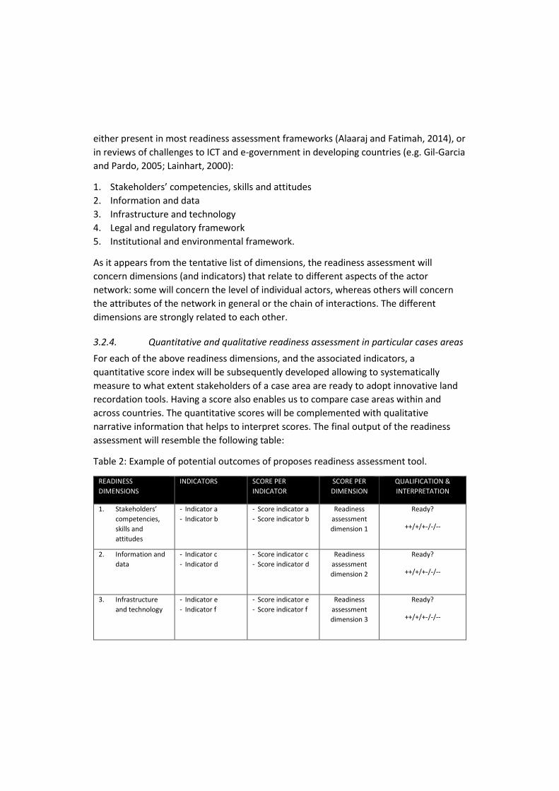
3.2.4. Quantitative and qualitative readiness assessment in particular cases areas
For each of the above readiness dimensions, and the associated indicators, a
quantitative score index will be subsequently developed allowing to systematically
measure to what extent stakeholders of a case area are ready to adopt innovative land
recordation tools. Having a score also enables us to compare case areas within and
across countries. The quantitative scores will be complemented with qualitative
narrative information that helps to interpret scores. The final output of the readiness
assessment will resemble the following table:
Table 2: Example of potential outcomes of proposes readiness assessment tool.
READINESS
DIMENSIONS
INDICATORS SCORE PER
INDICATOR
SCORE PER
DIMENSION
QUALIFICATION &
INTERPRETATION
1. Stakeholders’
competencies,
skills and
attitudes
- Indicator a
- Indicator b
- Score indicator a
- Score indicator b
Readiness
assessment
dimension 1
Ready?
++/+/+-/-/--
2. Information and
data
- Indicator c
- Indicator d
- Score indicator c
- Score indicator d
Readiness
assessment
dimension 2
Ready?
++/+/+-/-/--
3. Infrastructure
and technology
- Indicator e
- Indicator f
- Score indicator e
- Score indicator f
Readiness
assessment
dimension 3
Ready?
++/+/+-/-/--
4. Legal and
regulatory
framework
- Indicator g
- Indicator h
- Score indicator g
- Score indicator h
Readiness
assessment
dimension 4
Ready?
++/+/+-/-/--
5. Institutional and
environmental
framework
- Indicator i
- Indicator j
- Score indicator i
- Score indicator j
Readiness
assessment
dimension 5
Ready?
++/+/+-/-/--
This assessment will be based on a variety of data collection methods including
questionnaires/surveys, semi-structured interviews, workshops and human
observations. Finally, an overall readiness assessment will be developed by combining
the scores of the different dimensions.
3.3. Market Opportunities: Change Theory
Market opportunities are identified as gaps in product and service provision in the land
tenure sector, and relate to specific land tenure recording issues in East Africa.
Therefore, this research will provide a current state on the market and market’s needs,
and then, by comparing it with the desired state, identify the present gaps, so that
solutions and recommendations can be formulated in this respect. Inherently, a market
gap analysis is often a key strategy endorsed in change theory to determine readiness
(Beckhard and Harris, 1987); therefore, this research activity is closely associated with
the previous one.
Analysis of outputs from previous questionnaires, the actor network analysis and
MAMCA inputs and outcomes will support the definition of both current and desired
states. This will provide the foundation for in-depth interviews particularly focused on
private and commercial actors.
3.3.1. Establishing the current state
To build a base level understanding of the current context and market situation
pertaining to land tenure information recordation and use in each of the three countries
(focusing on the case areas), the outcomes of the data collection and analysis for
MAMCA and ANA will be leveraged to identify and quantify market characteristics. The
aim here is to provide a broad but comparable analysis of each of the country contexts.
The ANA described in the previous sub-section will serve to map and visualize current
characteristics of the relationships between stakeholders. This will identify transaction
flows between parts of the value system, make explicit organizational dependencies and
highlight significant sections of the value system (e.g. in transforming land tenure
information to other types of products and services. Similarly, outcomes of MAMCA
steps 1 to 3 will serve to provide qualitative characteristics of the current land tenure
recording system.
3.3.2. Establishing the desired state
Outputs from MAMCA will also serve to make explicit desired/ideal states relevant to
groups of stakeholders who have similar objectives. This data will be augmented by in-
depth interviews conducted with private and commercial stakeholders to obtain their
perspective on potential products and services. Factors of success for change to evolve
from current to desired states will be explored with experts and stakeholders in
workshops. Here, the intention is to identify several indicators of progress and to define
key factors of change.
Data collected will be then be analysed respective to current market conditions to
provide recommendations around potential market opportunities, and potentially help
to provide input into a country level implementation roadmap.
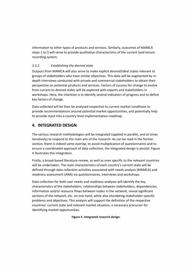
4. INTEGRATED DESIGN
The various research methodologies will be integrated (applied in parallel, and at times
iteratively) to respond to the main aim of the research. As can be read in the former
section, there is indeed some overlap; to avoid multiplication of questionnaires and to
ensure a coordinated approach of data collection, the integrated design is pivotal. Figure
4 illustrates this integration.
Firstly, a broad-based literature review, as well as ones specific to the relevant countries
will be undertaken. The main characteristics of each country’s current state will be
defined through data collection activities associated with needs analysis (MAMCA) and
readiness assessment (ANA) via questionnaires, interviews and workshops.
Data collection for both user needs and readiness analyses will identify the key
characteristics of the stakeholders, relationships between stakeholders, dependencies,
information and/or resource flows between nodes in the network, reveal significant
sections of the network, etc. on one hand, while also elucidating stakeholder-specific
problems and objectives. This analysis will support the definition of the respective
countries’ current state and relevant market situation, a necessary precursor for
identifying market opportunities.
Figure 4. Integrated research design.
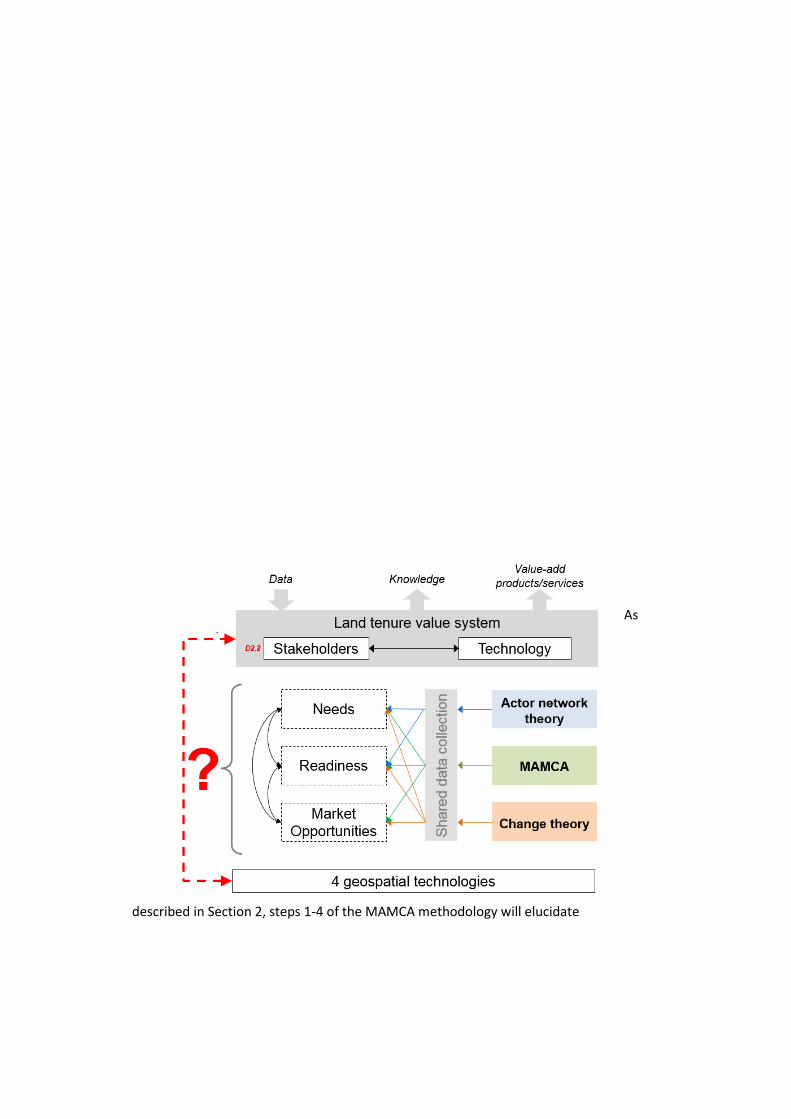
As
described in Section 2, steps 1-4 of the MAMCA methodology will elucidate
stakeholders’ needs specifically as problem definition, possible alternatives for using the
proposed technologies and objectives. Objectives are then translated into criteria, which
are weighted, before one or more measurable indicators are linked to each criterion.
These will then be analysed in Steps 5-6, which will support the identification of the
“ideal state” in terms of using these technologies in response to needs.
In parallel, deduced information about the current state and the ideal state will inform
the readiness assessment of each case area/country, of which key will be a visualized
network derived from ANA. This will support an aggregated perspective of readiness of
groups of stakeholders in adopting these technologies; as well, further ANA can be used
to support the visualization of various idealized actor-networks to support stakeholders’
determination of the future state. This will also provide some measure of input in the
development of an implementation roadmap.
Finally, outputs from the preceding research activities will provide input into identifying
market opportunities through gap analysis and interviews. The gap analysis will more
specifically elucidate current lack of abilities or services pertaining to processes,
technologies, skills, etc. Analysing these in relation to country/case area specific market
characteristics would identify potential market opportunities for product and service
providers. In parallel, interviews with the private sector will further refine these
recommendations.
5. APPLICATION OF THE RESEARCH DESIGN
The above methods description presents the ideal research design. Yet, from the case
study locations it is obvious that they differ in characteristics and complexity. It will
therefore be necessary to determine how exactly the different research methods will be
applied in the different case locations in a way that is feasible, integrated, valid and
consistent. Therefore, for the successful application, the following conditions and
prerequisites should be met.
First, depending on the case study, it will be necessary to delineate the number of
stakeholders to be interviewed per stage in the research design (needs; readiness;
market opportunities). It is likely that certain categories of stakeholders will be more
vital for the data collection in certain areas than in others. Likewise, the number of
participants per category might differ as well. While operationalizing the data collection,
the decision will be made per case study location as to who and for what purpose a
stakeholder will be questioned, interviewed or registered as participant at a group
discussion.
Second, while the previous paragraphs explicated the background of the data collection,
the application might differ slightly from the logical order presented there. It is obvious
that the methods presented form the scientific and methodological background of the
data collection. However, measuring needs, readiness and market opportunities will to a
large extent proceed simultaneously in order to avoid questioning the same
stakeholders multiple times. Where a stakeholder might have relevance for one or more
areas of interest, all effort will be made to coordinate field data collection exercises to
minimize the impact on stakeholders.
Third, though MAMCA, Readiness Analysis and gap analysis are presented as separate
vehicles to measure and analyse needs, readiness and market opportunities, the
integrated design reveals that there is indeed some overlap. This makes sense, because
needs, readiness and opportunities are of course interrelated. During the
operationalization of the research design, we will explore the feasibility and practicality
of extending each of the three frameworks to support data collection and analysis. Such
a mixed-method perspective will also serve to underpin to validity of the outcomes
(Creswell, 2009; Tashakkori & Teddlie, 1998).
Fourth, two case areas per three countries makes six in total. While preparing the
operationalization, it will be necessary to determine which and how data should be
collected per case study. It is possible that the same method will be used per country,
but it is equally possible that a different method will be necessary per case study. This
must be determined in collaboration with the other consortium members during the
course of the field data collection.
6. SHORT SUMMARY
Its4land delivers an innovative suite of land tenure recording tools that responds to sub-
Saharan Africa’s immense challenge to rapidly and cheaply map millions of unrecognized
land rights in the region. ICT innovation will play a key role. Existing
approaches have failed: disputes abound, investment is impeded, and the community’s
poorest lose out. Its4land reinforces strategic collaboration between the EU and East
Africa via a scalable and transferrable ICT solution. Established local, national, and
international partnerships drive the project results beyond R&D into the commercial
realm. its4land combines an innovation process with emerging geospatial technologies,
including smart sketchmaps, UAVs, automated feature extraction, and geocloud
services.
This paper provided the research design of the user-oriented part of the ‘its4land’-
project. It aims to capture stakeholders’ needs, readiness, and the market opportunities
regarding the application of the four geospatial innovative technologies by making use
of the Actor Network Theory, Multi-Actor Multi-Criteria Analysis and Change Theory. An
integrated design is also proposed to facilitate a coordinated approach to the
complicated data collection and analysis requirements.
This paper tried to elaborate the research design, which will be implemented during the
next stage. Based on the implementation findings, evaluations and related adjustments
will take place at a later phase of the research.
7. REFERENCES
Adam, A. G. (2014). Land Tenure in the Changing Peri‐Urban Areas of Ethiopia: The Case
of Bahir Dar City. International Journal of Urban and Regional Research, 38(6),
1970-1984.
Alaaraj, H., and Ibrahim, F. W. (2014). An overview and classification of e-readiness
assessment models. International Journal of Scientific and Research
Publications, 4(12).
Beckhard, R. and Harris, R. (1987). Organizational transitions: Managing complex
change. 2nd edition. Pearson Education Inc., Upper Saddle River, NJ.
Bennett, R. M., Van Gils, H.A.M. J., Zevenbergen, J. A., Lemmen, C.H. J., and Wallace, J.
(2013). Continuing tho bridge the cadastral divide. In: Proceedings of Annual
World and Conference on Land and Poverty, 8-11, 2013. Washington, DC: the
World Bank.
FAO. (2002). Land Tenure and Rural Development. Rome, Italy: FAO.
Gil-García, J. R., and Pardo, T. A. (2005). E-government success factors: Mapping
practical tools to theoretical foundations. Government information quarterly,
22(2), 187-216.
ISACA (2016). COBIT - http://www.isaca.org/Cobit/pages/default.aspx [accessed 15 July
2016].
Laarabi, A., Chevallier, J. J., and Martel, J. M. (1996). A spatial decision aid: A multi
criterion evaluation approach. Computers, Environment and Urban Systems,
20(6), 351–366.
Lainhart IV, J. W. (2000). COBIT™: A methodology for managing and controlling
information and information technology risks and vulnerabilities. Journal of
Information Systems, 14(s-1), 21-25.
Latour, B. (2005). Reassembling the social: An introduction to actor-network-theory
(Clarendon Lectures in Management Studies).
Macharis, C. (2005). The importance of stakeholder analysis in freight transport.
Quarterly Journal of Transport Law, Economics and Engineering, 8(25–26), 114–
126.
Macharis, C. and Crompvoets, J. (2014). A stakeholders-based assessment framework
applied to evaluate development scenarios for the spatial data infrastructure in
Flanders. Computers, Environment and Urban Systems, 46, 45-56.
Macharis, C., De Witte, A., and Ampe, J. (2009). The multi-actor, multi-criteria analysis
methodology (MAMCA) for the evaluation of transport projects: Theory and
practice. Journal of Advanced Transportation, 43(2), 183–202.
Porter, M. E. (1985). Competitive advantage. The Free Press, New York.Technology and
competitive advantage. Journal of business strategy, 5(3), 60-78.
Rayport, J.F. and Jaworksi, B.J. (2001). Cases in e-Commerce. McGraw-Hill Higher
Education.
Saaty, T. L. (1988). The analytic hierarchy process. New York: McGraw-Hill.
Siriba, D. N., Voß, W., & Mulaku, G. C. (2011). The Kenyan Cadastre and Modern Land
Administration. Zeitschrift fur Vermessungswesen, 136, 177-186.
Vancauwenberghe, G., Crompvoets, J., Bouckaert, G. and Vandenbroucke, D. (2011).
Social Network Analysis of the SDI in Flanders. In: Nedovic-Budic Z., Crompvoets
J., Georgiadou Y. (Eds.), Spatial Data Infrastructures in Context: North and
South, Chapter 6. CRC Press Taylor & Francis Group, 121-135.