Embed Size (px)
DESCRIPTION
Chris Cialek Statewide Advisory March 31, 2011. Geospatial Standards Status and Recommendations to the OET. Geospatial Standards. Approved Process for Developing Policies, Standards and Guidelines. Compliance. - PowerPoint PPT Presentation
Citation preview
Chris CialekStatewide AdvisoryMarch 31, 2011

Year Standard
1997
Codes for MN Counties
1998
State Agency Coordinate Interchange
1998
Geographic Metadata
2000
Positional Accuracy
1994 Codes for the Identification of States
2002 Codes for Lake and Wetland Basins
2006 Codes for Watersheds
2008 River Reach/Water Course IDs
2009 City, Township and Unorganized Territory Identifiers
2009 U.S. National Grid
- Stormwater Conveyance
- Thoroughfare, Landmark, and Postal Address Data Standard
- MN Geocode Model

1.0Propose Policy,
Standard or Guideline
2.0Develop Policy,
Standard or Guideline
3.0Adopt Policy, Standard or Guideline
4.0Implement Policy,
Standard or Guideline
Problem / Need
Proposed Policies, Standards and
Guidelines
Developed Policies, Standards and
Guidelines
Adopted Policies, Standards and
Guidelines
Identified need
Identified need
Stakeholder/partner input
Reviewer input
External reviewer input
Proposed policy, standard or guideline
Developed policy, standard or guideline
Approved Process for Developing Policies, Standards and Guidelines
\\adm-data.admin.state.mn.us\admindept\gda\home\ccialek\STANDARDS\Workgroups\IPO Process\Approved Process for PSG's for IPC-v2 B&W 3.vsd
Sponsor
Agency
IPCGI Council
"Community of interest"
AdminOffice of Technology
LEGEND:
IPC formalrecommendations
= out of scope
= process
= data / information (store)
= organization / stakeholder
Responsible
authority input
OT/Admin adopted policy, standard or guideline
(comes from external sources)
Approved Process for Developing Policies, Standards and Guidelines


What constitutes compliance? Agencies must be capable of translating their data into a form consistent with this standard for the purpose of exchanging data between organizations. Agencies may continue to store data in alternate formats of their choice, provided the capability exists to readily convert them.
How will compliance be measured? Evidence of compliance will be determined based on reports of satisfactory data transfers from receiving state, local and federal agencies, and private sector and citizen customers.

Use by Local Government? Use of this standard is recommended when local governments exchange data, or when any new public databases are being designed.
Use by local government, the private sector and the public in general is encouraged, but voluntary. This standard applies to data that are being transferred, and does not restrict how those data are internally stored.

2005 IPC sunsets OET created and IPO incorporated into it Process to ratify standards interrupted
2007 Standards Committee formed Geospatial Standards
Authorization Workgroup to try to influence reinstatement of standards process (see 2008 work plan)
2008 Met with OET Director of Strategic Planning:
Offered to include GI standards on OET web site without ratification pending development of a new governance model that is in progress

State CIO
All CIO Team
Architecture Review
Board
Info/Data Domain Team
Subject Matter Experts

Year Standard
1997
Codes for MN Counties
1998
State Agency Coordinate Interchange
1998
Geographic Metadata
2000
Positional Accuracy
1994 Codes for the Identification of States
2002 Codes for Lake and Wetland Basins
2006 Codes for Watersheds
2008 River Reach/Water Course IDs
2009 City, Township and Unorganized Territory Identifiers
2009 U.S. National Grid
- Stormwater Conveyance
- Thoroughfare, Landmark, and Postal Address Data Standard
- MN Geocode Model
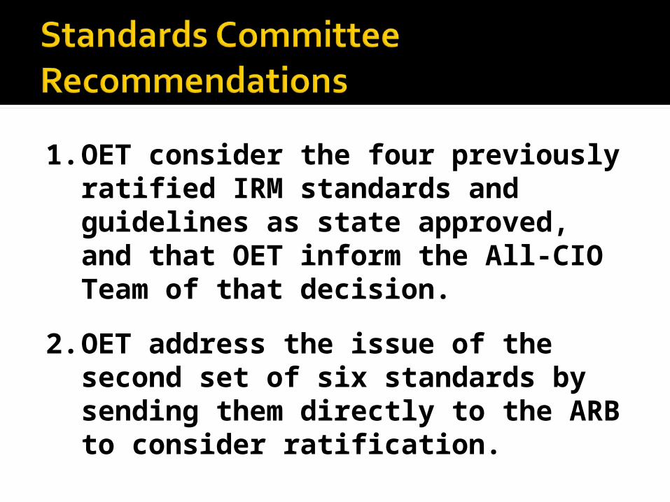
1. OET consider the four previously ratified IRM standards and guidelines as state approved, and that OET inform the All-CIO Team of that decision.
2. OET address the issue of the second set of six standards by sending them directly to the ARB to consider ratification.
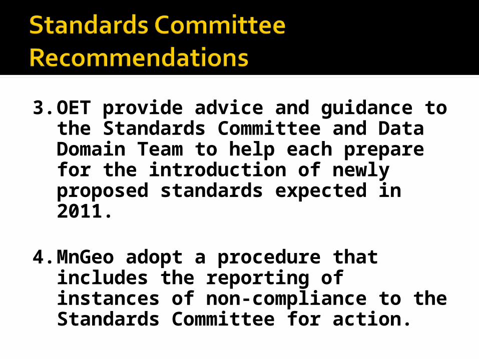
3. OET provide advice and guidance to the Standards Committee and Data Domain Team to help each prepare for the introduction of newly proposed standards expected in 2011.
4. MnGeo adopt a procedure that includes the reporting of instances of non-compliance to the Standards Committee for action.

Jan 11: Recommendations brought to State Agency Advisory
Jan 26: Presented to the ARB Feb 1: Met with Architecture Core Team to
begin working out details Feb 8: Standards Committee met; set up
Metadata Standard Review committee Mar 10: OET Data Domain Team responds:
Invited to send standards to AC Team for vetting Assist OET put standards in new template for
web publishing
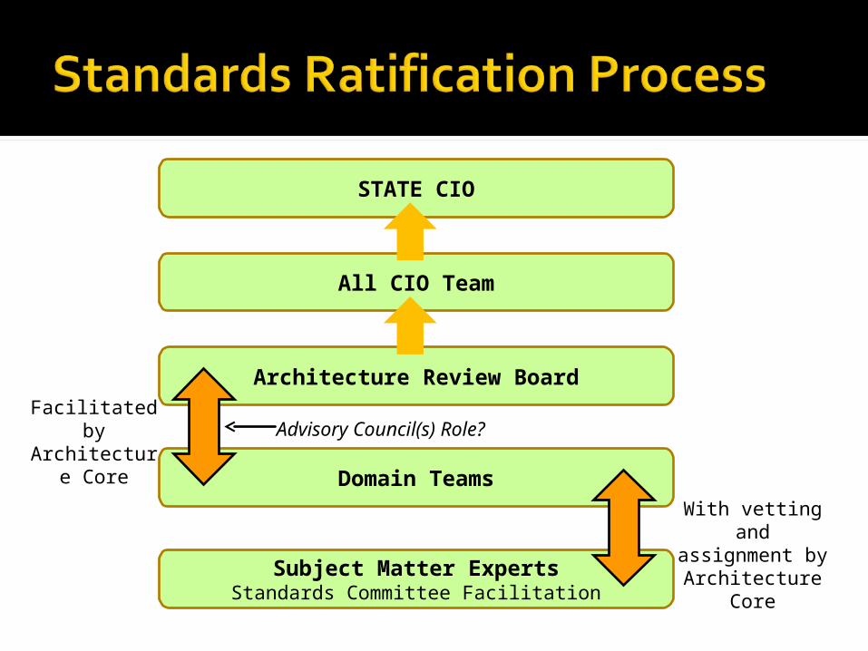
Subject Matter ExpertsStandards Committee Facilitation
Domain Teams
Architecture Review Board
STATE CIO
All CIO Team
With vetting and assignment by
Architecture Core
Facilitated by Architecture
CoreAdvisory Council(s) Role?

Formally submit standards to Architecture Core Group for re-consideration
Reorganize web publication material to fit OET‘s new template
Participate in Metadata WorkgroupContinue to move new standards
through Committee