Embed Size (px)
Citation preview

Geospatia
l S
cie
nce P
rog
ram
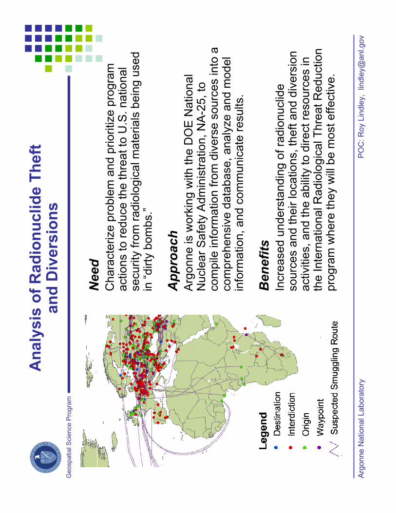
Need
Chara
cte
rize p
roble
m a
nd p
rioritize p
rogra
m
actions to r
educe the thre
at to
U.S
. national
security
fro
m r
adio
logic
al m
ate
rials
bein
g u
sed
in “
dirty
bom
bs.”
Approach
Arg
onne is w
ork
ing w
ith the D
OE
National
Nucle
ar
Safe
ty A
dm
inis
tration, N
A-2
5, to
co
mp
ile in
form
atio
n fro
m d
ive
rse
so
urc
es in
to a
com
pre
hensiv
e d
ata
base, analy
ze a
nd m
odel
info
rmation, and c
om
munic
ate
results.
Benefits
Incre
ased u
nders
tandin
g o
f ra
dio
nuclid
e
sourc
es a
nd their locations, th
eft
and d
ivers
ion
activitie
s, and the a
bili
ty to d
irect re
sourc
es in
the Inte
rnational R
adio
logic
al T
hre
at R
eduction
pro
gra
m w
here
they w
ill b
e m
ost effective.
PO
C:
Roy L
indle
y,
lin
dle
y@
anl.gov
Arg
onne N
ational Labora
tory
An
aly
sis
of
Rad
ion
uclid
e T
heft
an
d D
ivers
ion
s
Geospatia
l S
cie
nce P
rog
ram
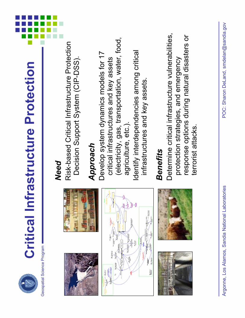
Cri
tical In
frastr
uctu
re P
rote
cti
on
PO
C:
Sharo
n D
eLand,
sm
dela
n@
sandia
.gov
Arg
onne,
Los A
lam
os,
Sandia
National Labora
tories
Need
Ris
k-b
ased C
ritical In
frastr
uctu
re P
rote
ction
Decis
ion S
upport
Syste
m (
CIP
-DS
S).
Approach
Develo
p s
yste
m d
ynam
ics m
odels
for
17
critical in
frastr
uctu
res a
nd k
ey a
ssets
(e
lectr
icity, gas, tr
ansport
ation, w
ate
r, food,
agriculture
, etc
.).
Identify
inte
rdependencie
sam
ong c
ritical
infr
astr
uctu
res a
nd k
ey a
ssets
.
Benefits
Dete
rmin
e c
ritical in
frastr
uctu
re v
uln
era
bili
ties,
pro
tection s
trate
gie
s, and e
merg
ency
response o
ptions d
uring n
atu
ral dis
aste
rs o
r te
rrorist attacks.

Geospatia
l S
cie
nce P
rog
ramEm
erg
en
cy P
lan
nin
g a
nd
Pre
pare
dn
ess
for
Sp
ecia
l-N
eed
s P
op
ula
tio
ns
Need
Som
e indiv
iduals
lack the p
hysic
al or
menta
l capacity to im
ple
ment evacuation o
rders
or
oth
er
pro
tective a
ctions in e
merg
encie
s.
Em
erg
ency p
lanners
and r
esponders
need to
unders
tand a
nd p
lan for
these issues.
Approach
Specia
l P
opula
tion P
lanner
(SP
P)
softw
are
and
a v
olu
nta
ry r
eg
istr
y o
f in
form
atio
n fro
m p
ers
on
s
with s
pecia
l needs w
as p
roduced b
y A
rgonne for
the A
labam
a E
merg
ency M
anagem
ent A
gency.
Benefits
SP
P s
oftw
are
can b
e e
asily
configure
d for
all-
hazard
s a
naly
sis
and a
ny g
eogra
phic
are
a. A
cost-
effective m
eth
odolo
gy for
com
pili
ng
specia
l-needs d
ata
has b
een e
sta
blis
hed.
Handlin
g o
f specia
l-needs issues in the
Ala
bam
a p
roje
ct are
a h
as b
een im
pro
ved.
PO
Cs:
Ed T
anzm
an,
tanzm
an@
anl.gov
Arg
onne N
ational Labora
tory

Geospatia
l S
cie
nce P
rog
ram
Thre
e r
ole
s f
or
geospatial data
in N
AR
AC
:
1.
Model calc
ula
tions
2.
Health e
ffects
usin
g d
ay/n
ight popula
tion
3.
Pro
duct
base m
aps
Geo
sp
ati
al D
ata
in
NA
RA
C
PO
C:
Hoyt
Walk
er,
hw
alk
er@
llnl.gov
Law
rence L
iverm
ore
National Labora
tory
Need
The N
ational A
tmospheric R
ele
ase A
dvis
ory
Cente
r (N
AR
AC
) pro
vid
es tools
and s
erv
ice
s t
ha
t m
ap
th
e
spre
ad o
f hazard
ous m
ate
rial in
the a
tmosphere
.
Approach
NA
RA
C is a
national cente
r fo
r pla
nnin
g,
pre
pare
dness, em
erg
ency r
esponse, and
assessm
ents
involv
ing a
wid
e v
ariety
of hazard
s,
inclu
din
g n
ucle
ar,
radio
logic
al, c
hem
ical, b
iolo
gic
al or
natu
ral em
issio
ns.
Benefits
NA
RA
C p
roducts
pro
vid
e info
rmation o
n a
ffecte
d
are
as, pote
ntial casualtie
s, h
ea
lth
eff
ects
, a
nd
re
com
mended p
rote
ctive a
ctions.
NA
RA
C h
as n
ational and g
lobal re
sponsib
ilities a
nd
responds a
t a w
ide r
ange o
f dom
ain
siz
es, w
hic
h
necessitate
s a
larg
e r
equirem
ent
for
multi-scale
geospatial in
form
ation.
Th
is w
ork
wa
s p
erf
orm
ed
un
de
r th
e a
usp
ice
s o
f th
e U
.S. D
ep
art
me
nt of E
ne
rgy
by t
he
Un
ive
rsity o
f C
alif
orn
ia, L
aw
ren
ce
Liv
erm
ore
Na
tio
na
l L
ab
ora
tory
un
de
r
co
ntr
act N
o. W
-74
05
-En
g-4
8.
U
CR
L-P
RE
S-2
18
02
9
NA
RA
C d
ispe
rsio
n p
atte
rns c
an b
e
transfe
rred to c
om
me
rcia
l G
IS fo
r
dis
pla
y a
nd a
na
lysis
with
oth
er
data
.

Geospatia
l S
cie
nce P
rog
ram
Cri
tical In
frastr
uctu
re P
rote
cti
on
PO
Cs:
Randy M
ichels
en,
rem
@la
nl.gov
/ T
here
sa B
row
n,
tjbro
wn@
sandia
.gov
Los A
lam
os a
nd S
andia
National Labora
tories
Need
GIS
support
for
the N
ational In
frastr
uctu
re
Sim
ula
tion a
nd A
naly
sis
Cente
r (N
ISA
C).
Approach
GIS
-based tools
for
modelin
g, sim
ula
tion, and
analy
sis
of critical in
frastr
uctu
res, th
eir
inte
rdependencie
s, com
ple
xitie
s a
nd p
ote
ntial
consequences o
f dis
ruptions.
Ap
ply
NIS
AC
to
ols
Su
pp
ort
to
DH
S
Unders
ecre
tary
for
Em
erg
ency P
repare
dness
& R
esponse, D
OE
Off
ice o
f E
nerg
y A
ssura
nce
and o
ther
federa
l agencie
s.
Benefits
Addre
ss inte
rdependency issues (
polic
y,
pla
nnin
g, crisis
response a
nd
education/tra
inin
g)
at national, r
egio
nal, u
rban
and m
etr
opolit
an s
cale
s.
Geospatia
l S
cie
nce P
rog
ram
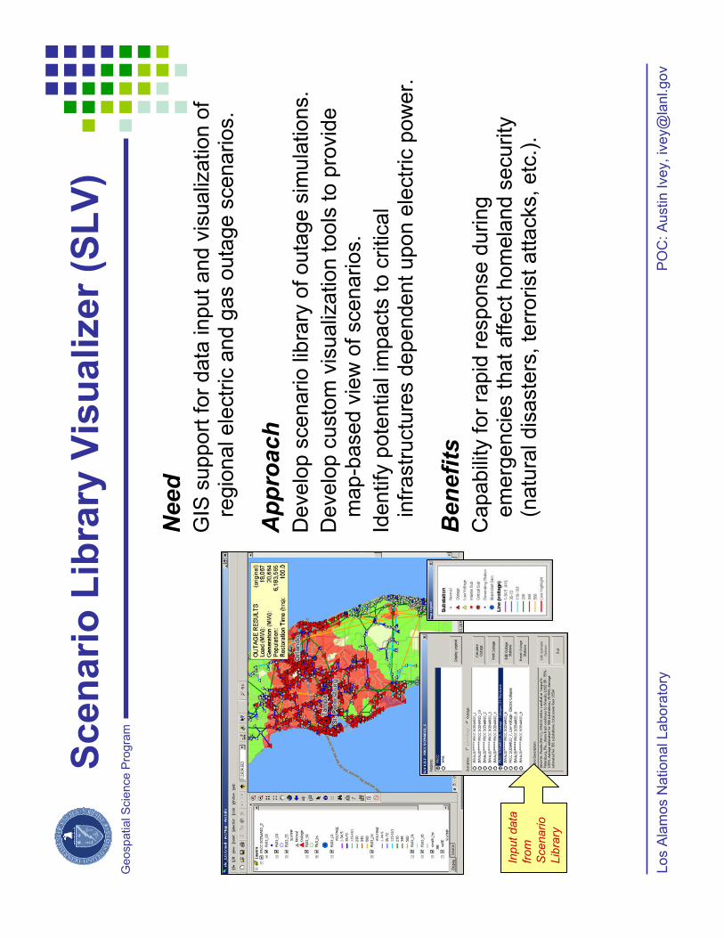
Scen
ari
o L
ibra
ry V
isu
alizer
(SL
V)
PO
C:
Austin I
vey,
ivey@
lanl.gov
Los A
lam
os N
ational Labora
tory
Need
GIS
support
for
data
input and v
isualiz
ation o
f re
gio
nal ele
ctr
ic a
nd g
as o
uta
ge s
cenarios.
Approach
Develo
p s
cenario lib
rary
of outa
ge s
imula
tions.
Develo
p c
usto
m v
isualiz
ation tools
to p
rovid
e
map-b
ased v
iew
of scenarios.
Ide
ntify
po
ten
tia
l im
pa
cts
to
critica
l in
frastr
uctu
res d
ependent upon e
lectr
ic p
ow
er.
Benefits
Ca
pa
bili
ty fo
r ra
pid
re
sp
on
se
du
rin
g
em
erg
encie
s that aff
ect hom
ela
nd s
ecurity
(n
atu
ral dis
aste
rs, te
rrorist attacks, etc
.).
Input data
from
Scenario
Lib
rary
Geospatia
l S
cie
nce P
rog
ramSeco
nd
Lin
e o
f D
efe
nse (
SL
D)
PO
C:
Kevin
Saeger,
saeger@
lanl.gov
Los A
lam
os N
ational Labora
tory
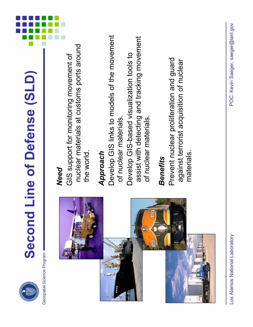
Need
GIS
support
for
monitoring m
ovem
ent of
nucle
ar
mate
rials
at custo
ms p
ort
s a
round
the w
orld.
Approach
Develo
p G
IS lin
ks to m
odels
of th
e m
ovem
ent
of nucle
ar
mate
rials
.
Develo
p G
IS-b
ased v
isualiz
ation tools
to
assis
t w
ith d
ete
cting a
nd tra
ckin
g m
ovem
ent
of nucle
ar
mate
rials
.
Benefits
Pre
vent nucle
ar
pro
lifera
tion a
nd g
uard
again
st te
rrorist acquis
itio
n o
f nucle
ar
mate
rials
.

Geospatia
l S
cie
nce P
rog
ram
Em
erg
en
cy
Pre
pa
red
ne
ss
an
d R
es
po
ns
e
Need
To s
upport
the O
ffic
e f
or
Ele
ctr
icity D
eliv
ery
& E
nerg
y
Relia
bili
ty,
Infr
astr
uctu
re a
nd E
nerg
y R
esto
ration
Div
isio
n’s
Vis
ualiz
ation a
nd M
odelin
g W
ork
gro
up
during n
atu
ral or
technolo
gic
al dis
aste
rs.
Approach
Usin
g a
variety
of to
ols
and w
ork
ing u
nder
the
coord
ination o
f N
ET
L, subje
ct
ma
tte
r e
xp
ert
s f
rom
severa
l of D
OE
’s N
ational Labora
tories levera
ge
exis
ting e
xpert
ise to r
espond t
o n
atu
ral and m
an-m
ade
em
erg
encie
s that im
pact energ
y infr
astr
uctu
re.
Benefit
Oak R
idge N
ational Labora
tory
’s G
IST
gro
up p
rovid
es
expert
ise o
n p
opula
tion d
ynam
ics, dem
ogra
phic
analy
sis
, m
ultim
odal com
modity flo
w a
naly
sis
, and
transport
ation r
outing a
nd c
ontingency p
lannin
g.
68
7,1
01
5,5
92
,95
6T
ota
l
22
4,2
79
1,7
01
,59
32
5%
18
4,3
72
1,5
05
,19
65
0%
18
7,6
77
1,5
94
,80
67
5%
90
,77
37
91
,36
11
00
%
SE
NIO
R
TO
TA
L
PO
PU
LA
TIO
ND
AM
AG
E
Oak R
idge N
ational Labora
tory
PO
C: B
udhendra
Bhaduri,
bhaduribl@
orn
l.gov

Geospatia
l S
cie
nce P
rog
ram
Data
Searc
h &
Retr
ieval
Data
Searc
h &
Retr
ieval
Ge
oc
on
form
an
ce
Ge
oc
on
form
an
ce
Seg
men
tati
on
Seg
men
tati
on
Featu
re M
ap
pin
gF
eatu
re M
ap
pin
g
Imag
e-t
o-I
nte
llig
en
ce A
rch
ive (
I2IA
)
Need
The a
mount of data
availa
ble
to im
age a
naly
sts
to
day is e
norm
ous, ty
pic
ally
exceedin
g m
ultip
le
tera
byte
s a
nd h
undre
ds o
f th
ousands o
f in
div
idu
al im
ag
e file
s.
Approach
Develo
pm
ent of an a
gent-
based s
yste
m
arc
hitectu
re that auto
nom
ously
manages a
m
assiv
e b
ut dynam
ic im
age d
ata
arc
hiv
e that
transfo
rms d
ata
to a
n inte
lligence a
rchiv
e to a
id
national security
needs.
Benefit
Effectively
and e
ffic
iently m
anagin
g tera
byte
s o
f im
ag
e d
ata
is e
sse
ntia
l to
ra
pid
re
sp
on
se
to
dis
cre
te e
vents
and a
ssessm
ent of th
reats
and
vuln
era
bili
ties. A
llow
s r
apid
vis
ual query
to
retr
ieve s
imila
r obje
cts
in a
rchiv
e a
nd c
hange
dete
ction in a
space-t
ime fra
mew
ork
.
Oak R
idge N
ational Labora
tory
PO
C: B
udhendra
Bhaduri,
bhaduribl@
orn
l.gov

Geospatia
l S
cie
nce P
rog
ram
Hy
dro
log
ic T
ran
sp
ort
As
se
ss
me
nt
Sy
ste
m
(HY
TR
AS
)
Need
Nucle
ar,
bio
logic
al and c
hem
ical agents
ente
r w
ate
rways fro
m m
any s
ourc
es: in
dustr
ial
facili
ties a
dja
cent to
wate
rways, vessels
tr
avelin
g o
n w
ate
rways, surf
ace d
epositio
n o
f airborn
e m
ate
rials
, and o
thers
.
Approach
Applic
ation a
nd inte
gra
tion o
f w
ate
rshed
modelin
g techniq
ues (
based o
n U
SD
A’s
NR
CS
ra
infa
ll-ru
noff m
odel, n
on-p
oin
t conta
min
ant
data
, pre
cip
itation, te
mpera
ture
, soil
type, la
nd
use/land c
over,
and p
opula
tion d
istr
ibution
data
sets
).
Benefit
HY
TR
AS
pre
dic
ts the tra
nsport
of nucle
ar,
bio
logic
al, a
nd c
hem
ical agents
in s
urf
ace
wate
rs, and d
ow
nstr
eam
exposure
ris
k
assessm
ent re
sultin
g fro
m incid
ents
.
Oak R
idge N
ational Labora
tory
PO
C: B
udhendra
Bhaduri,
bhaduribl@
orn
l.gov

Geospatia
l S
cie
nce P
rog
ram
Sen
so
rNet
Need
The e
merg
ing technic
al in
novations in p
ublic
safe
ty w
ill
be info
rmation technolo
gie
s: W
irele
ss D
ata
/Mobile
C
om
puting, In
telli
gent V
ideo S
urv
eill
ance, G
IS,
Situation A
ware
ness, Location-B
ased S
erv
ices (
GP
S),
R
FID
Taggin
g, S
ensor
Netw
ork
s, B
iom
etr
ics,
Fore
casting,
Info
rmation F
usio
n, and A
naly
tics.
Approach
Thro
ugh c
olla
bora
tion w
ith O
pen G
eospatial
Consort
ium
(O
GC
), t
he N
ational In
stitu
te f
or
Sta
ndard
s a
nd T
echnolo
gy (
NIS
T),
and t
he
Org
aniz
ation f
or
the A
dvance
me
nt o
f S
tructu
red
In
form
ation S
tandard
s (
OA
SIS
), p
rom
ote
in
tero
pera
bili
ty a
nd info
rmation s
haring s
tandard
s f
or
inte
rfacin
g a
uto
nom
ous s
ensor
netw
ork
s.
Benefit
Deplo
ym
ent
of
SensorN
et
test
be
ds in
a v
arie
ty o
f lo
cations a
nd o
pera
tional settin
gs t
ha
t te
st
an
d r
efin
e
va
rio
us a
sp
ects
of
the
em
erg
ing t
echnic
al solu
tions.
Ra
dio
log
ica
l
Ch
em
ica
l
Mete
oro
log
ical
Bio
log
ica
l
Co
mm
an
d-a
nd
-Co
ntr
ol
Pe
rfo
rman
ce S
up
po
rt
An
aly
sis
, M
od
elin
g, an
d P
red
icti
on
Oak R
idge N
ational Labora
tory
PO
C: B
udhendra
Bhaduri,
bhaduribl@
orn
l.gov

Geospatia
l S
cie
nce P
rog
ram
Inte
llig
en
t C
on
se
qu
en
ce
Ma
na
ge
me
nt
Need
Exis
ting c
onsequent m
anagem
ent appro
aches
are
constr
ain
ed b
y lack o
f in
tegra
tion o
f behavio
ral, s
ocia
l, a
nd p
hysic
al m
odels
and
sp
atia
l d
ata
.
Approach
Inte
gra
te s
ound b
ehavio
ral assum
ptions,
dynam
ic tra
ffic
assig
nm
ent, a
nd h
igh-
resolu
tion d
em
ogra
phic
data
in a
GIS
fr
am
ew
ork
for
an e
vacuation m
odel.
Benefit
Allo
ws local pla
nnin
g a
nd r
esponse a
naly
sis
on a
national basis
to a
ssess r
eal tim
e
consequence a
naly
sis
, com
poundin
g effects
fr
om
dis
aste
rs, and e
nerg
y im
pacts
of
dis
aste
rs.
Oak R
idge N
ational Labora
tory
PO
C: B
udhendra
Bhaduri,
bhaduribl@
orn
l.gov

Geospatia
l S
cie
nce P
rog
ram
Em
erg
en
cy R
esp
on
se G
IS a
nd
Wir
ele
ss
Tech
no
log
y
Need
Te
lem
etr
y s
yste
ms a
re n
ecessary
to
allo
w
em
erg
ency r
esponse o
rganiz
ations to p
rovid
e fie
ld
data
, fa
ste
r, a
nd w
ith g
reate
r re
liabili
ty t
o d
ecis
ion
makers
during a
nucle
ar
incid
ent.
Approach
Real-T
ime D
ata
Acquis
itio
n a
nd D
issem
ination
(RD
AD
) is
an a
rchitectu
re b
ein
g d
evelo
ped a
t th
e D
OE
R
em
ote
Sensin
g L
abora
tory
(R
SL)
that allo
ws m
obile
data
acquis
itio
n p
latform
s to m
ove d
ata
thro
ugh a
ny I
P
com
munic
ation c
hannel to
centr
al com
mand a
nd
contr
ol assets
.Im
ple
menta
tion o
f th
is s
yste
m is b
ein
g
appro
ached w
ithin
exis
ting o
pera
tional, s
ecurity
, and
netw
ork
ing c
onstr
ain
ts.
Benefits
As fie
ld d
ata
are
colle
cte
d a
nd t
ransm
itte
d,
they a
re
made a
vaila
ble
for
real-
tim
e d
ispla
y a
nd a
naly
sis
usin
g
inte
rnet
mappin
g a
pplic
ations. T
his
pro
vid
es
imm
edia
te a
ccess to v
alu
able
em
erg
ency info
rmation
by d
ecis
ion m
akers
acro
ss the c
ountr
y.
PO
C:
Jam
es E
ssex,
essexjj@
nv.d
oe.g
ov
Rem
ote
Sensin
g L
abora
tory
Geospatia
l S
cie
nce P
rog
ram
GIS
fo
r N
uc
lea
r E
me
rge
nc
y R
es
po
ns
e
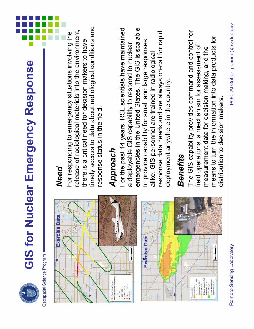
Need
For
respondin
g to e
merg
ency s
ituations involv
ing the
rele
ase o
f ra
dio
logic
al m
ate
ria
ls in
to t
he
en
viro
nm
en
t,th
ere
is a
critical need f
or
decis
ion m
akers
to h
ave
tim
ely
access to
da
ta a
bo
ut
radio
logic
al conditio
ns a
nd
response s
tatu
s in t
he f
ield
.
Approach
For
the p
ast
14 y
ears
, R
SL s
cie
ntists
have m
ain
tain
ed
a d
eplo
yable
GIS
capabili
ty to r
espond t
o n
ucle
ar
em
erg
encie
s in the U
nited S
tate
s.
The G
IS is s
cala
ble
to
pro
vid
e c
apabili
ty for
sm
all
and larg
e r
esponses
alik
e. G
IS p
ers
onnel are
tra
ined in r
adio
logic
al
response d
ata
needs a
nd a
re a
lways o
n-c
all
for
rapid
deplo
ym
ent anyw
here
in
th
e c
ou
ntr
y.
Benefits
The G
IS c
apabili
ty p
rovid
es c
om
mand a
nd c
ontr
ol fo
r field
opera
tions,
a m
echanis
m f
or
assessm
ent
of
measure
ment
data
for
decis
ion m
akin
g,
and t
he
means t
o t
urn
the info
rmation into
data
pro
ducts
for
dis
trib
ution to d
ecis
ion m
akers
.
PO
C:
Al G
uber,
gubera
oe.g
ov
Rem
ote
Sensin
g L
abora
tory
Exerc
ise D
ata
Exerc
ise D
ata
Geospatia
l S
cie
nce P
rog
ramKatr
ina R
esp
on
se G
IS S
up
po
rt
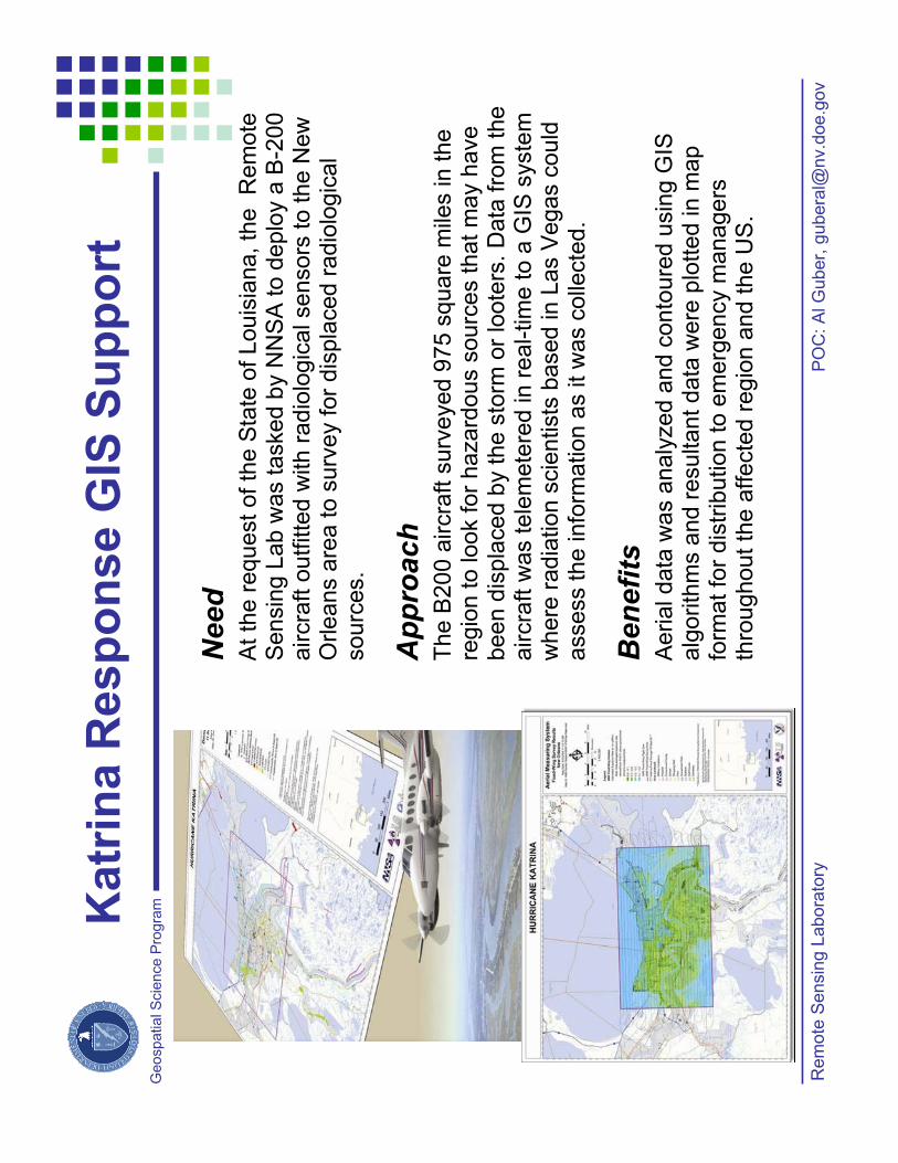
Need
At
the
re
qu
est
of
the
Sta
te o
f Louis
iana,
the
Rem
ote
S
ensin
g L
ab w
as tasked b
y N
NS
A to d
eplo
y a
B-2
00
aircra
ft o
utfitte
d w
ith r
adio
logic
al sensors
to t
he N
ew
O
rleans a
rea t
o s
urv
ey f
or
dis
pla
ced r
adio
logic
al
so
urc
es.
Approach
The B
200 a
ircra
ft s
urv
eyed 9
75 s
quare
mile
s in the
regio
n to look for
hazard
ous s
ou
rce
s t
ha
t m
ay h
ave
been d
ispla
ced b
y the s
torm
or
loote
rs.
Data
fro
m the
aircra
ft w
as t
ele
me
tere
din
re
al-tim
e t
o a
GIS
syste
m
where
radia
tion s
cie
ntists
based in L
as V
egas c
ould
a
ssess th
e in
form
atio
n a
s it w
as c
olle
cte
d.
Benefits
Aerial data
was a
naly
zed a
nd c
onto
ure
d u
sin
g G
IS
alg
orith
ms a
nd r
esultant
data
were
plo
tted in m
ap
form
at
for
dis
trib
ution t
o e
merg
ency m
anagers
th
roughout
the a
ffecte
d r
egio
n a
nd t
he U
S.
PO
C:
Al G
uber,
gubera
oe.g
ov
Rem
ote
Sensin
g L
abora
tory

Geospatia
l S
cie
nce P
rog
ramS
RS
Re
mo
te W
ork
er
Pro
gra
m
Need
To
pro
vid
e c
en
tra
lize
d tra
ckin
g a
nd
accounta
bili
ty for
work
ers
at re
mote
locations.
Approach
Utiliz
e d
ata
ba
se
ta
ble
s a
nd g
eogra
phic
event
them
es to a
llow
editin
g b
y m
ultip
le d
ispatc
hers
to
a c
entr
aliz
ed d
ata
base.
Benefits
Notifies d
ispatc
her
if a
rea is r
estr
icte
d (
keeps
work
er
safe
).
Notifies d
ispatc
her
when w
ork
er
is o
verd
ue.
Pro
vid
es p
ers
onnel accounta
bili
ty in c
ase o
f site
em
erg
ency.
Coord
inate
s e
merg
ency s
erv
ices for
pers
onnel.
Imple
ments
consis
tent sta
ndard
s, re
quirem
ents
, expecta
tions.
Help
s to c
reate
com
munity o
f tr
ain
ed
dis
patc
hers
.
Re
mo
te
Wo
rke
r
Web
pag
e
Re
mo
te W
ork
er
Map
PO
C:
D.
M.
Isim
ing
er,
Jr.
/ d
avid
.isim
inger@
srs
.gov
Savannah R
iver
Site
Geospatia
l S
cie
nce P
rog
ram
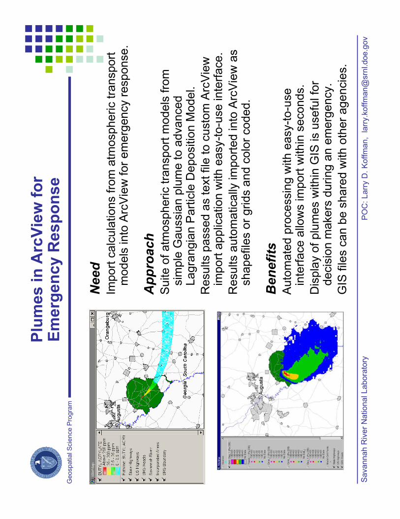
Need
Import
calc
ula
tions fro
m a
tmospheric tra
nsport
m
odels
into
Arc
Vie
wfo
r em
erg
ency r
esponse.
Approach
Suite o
f atm
ospheric tra
nsport
models
fro
m
sim
ple
Gaussia
n p
lum
e to a
dvanced
Lagra
ngia
nP
art
icle
Depositio
n M
odel.
Results p
assed a
s text file
to c
usto
m A
rcV
iew
import
applic
ation w
ith e
asy-t
o-u
se inte
rface.
Results a
uto
matically
im
port
ed into
Arc
Vie
wa
s
sh
ap
efile
so
r g
rid
s a
nd
co
lor
co
de
d.
Benefits
Auto
mate
d p
rocessin
g w
ith e
asy-t
o-u
se
inte
rface a
llow
s im
port
within
seconds.
Dis
pla
y o
f plu
mes w
ithin
GIS
is u
sefu
l fo
r decis
ion m
akers
during a
n e
merg
ency.
GIS
file
s c
an b
e s
hare
d w
ith o
ther
agencie
s.
PO
C:
La
rry D
. K
off
ma
n,
larr
y.k
off
man@
srn
l.do
e.g
ov
Savannah R
iver
National Labora
tory
Plu
mes in
Arc
Vie
wfo
r E
me
rge
nc
y R
es
po
ns
e

Geospatia
l S
cie
nce P
rog
ram
Need
Analy
ze 5
0 y
ears
of w
ind d
ata
over
the S
outh
east
for
tem
pora
l and s
patial tr
ends.
Approach
A w
indro
se
is a
gra
phic
repre
senta
tion o
f w
ind v
elo
city
frequency o
ver
som
e p
eriod o
f tim
e, show
ing s
peed
ranges a
nd d
irection.
Auto
mate
d p
rocessin
g o
f w
ind d
ata
with a
custo
m
Arc
Vie
wapplic
ation c
reate
s w
indro
se
shapefile
sfo
r gra
phic
dis
pla
y.
The w
indro
se
shapefile
sare
locate
d g
eogra
phic
ally
usin
g s
tation c
oord
inate
s.
Benefits
Auto
mate
d p
rocessin
g to c
reate
win
dro
se
gra
phic
s
allo
ws for
easy c
reation o
f th
ousands o
f w
indro
ses
repre
senting v
ari
ous tim
e r
anges.
Geogra
phic
pla
cem
ent
of
win
dro
ses
allo
ws for
vis
ual
corr
ela
tion o
f spatial re
lationship
s.
Auto
mation a
llow
s for
movie
s t
o b
e g
enera
ted.
PO
C:
La
rry D
. K
off
ma
n,
larr
y.k
off
man@
srn
l.do
e.g
ov
Savannah R
iver
National Labora
tory
Win
dro
se
An
aly
sis
in
a
Geo
sp
ati
al F
ram
ew
ork