Embed Size (px)
Citation preview
Geospatial Maturity Index (GMI)
GMI Survey Walk-through Guide & Methodology
May 2019
GMI Survey Walk-through Guide & Methodology
P a g e | 1 © 2019 PSD ALL RIGHTS RESERVED
Introduction
The Geospatial Maturity Index (GMI) is the latest addition to the suite of public sector benchmarking
initiatives developed by the Public Sector Digest. The GMI serves to audit existing GIS programs and allow
participating public sector organizations to compare themselves against their peer groups and track their
progress over time based on specific core competencies.
The GMI provides participants with access to accurate and comprehensive comparative information to
assist with GIS program development and capacity building across organizations. Webinars and virtual
roundtable meetings help participants share best practices and spur on innovation. The results of this
survey will solely be used to inform a national analysis of geospatial maturity for the public sector.
Individual survey results and comparative rankings will be provided back to each respondent, comparing
their organization to the national average. Respondents can also opt to receive a specialized State of
Maturity report which will detail the organization’s program gaps and provide trend analysis comparing
to similar organizations of type and size. Additionally, aggregated survey results will inform several
themed reports to be published openly to geospatial communities providing greater insights.
Completing the Survey
Survey respondents are encouraged to reference the following survey walk-through guide to assist with
the completion of the 2019 GMI survey in SurveyMonkey. Explanations of each question included in the
survey can be found in this walk-through guide, which PSD has developed to provide clarification around
potentially new or unfamiliar concepts. The survey consists of scored and unscored questions, which
have been labelled as such in this walk-through guide and within the survey itself. The survey consists of
four sections: Organization Information, Readiness, Implementation, and Impact. Respondents can
complete the survey within SurveyMonkey at their own pace, with the application saving the latest
entries into the survey as long as the survey is completed from the same IP address. We encourage
respondents to work collaboratively across relevant departments to complete the survey, facilitating the
development of a corporate-wide view of your GIS program.
Please contact us at [email protected] if you have any questions or problems with completing the survey.
START THE SURVEY HERE: https://www.surveymonkey.com/r/geospatialmaturity2019
GMI Survey Walk-through Guide & Methodology
P a g e | 2 © 2019 PSD ALL RIGHTS RESERVED
Organization Information
1. Contact Information. (Unscored)
2. Organization Information. US respondents within a local government entity (County, City,
Town, etc.) should select Single-Tier municipality unless another option is more applicable.
(Unscored)
3. Please provide the number of employees working in your entire organization in terms of total
full-time and full-time equivalent staff. (Unscored)
Readiness
Sub-category: Program Structure
4. Geospatial data programs can exist as independent entities within some organizations (Centralized), while in others, GIS staff are integrated throughout various departments and rely on cross-departmental operations (Decentralized). Hybrid organizations fit somewhere in-between where geospatial data programs operate somewhat independently but maintain some cross-departmental operational requirements. This question seeks to determine how centralized or decentralized your organization’s geospatial data program is. (Unscored)
5. This question looks to determine if your organization has a GIS-specific team (or department). If your organization has a decentralized GIS team, but a well-defined GIS program, please indicate “yes”, or describe your unique program in “other.” (Scored)
6. This question is intended to provide an accurate picture of how many GIS staff (including part-time) work within the organization - this may be within one centralized department or decentralized across several departments. (Unscored)
7. This question looks to identify if your organization has full time staffing resources to the GIS department/team or if operations are maintained on a part time basis (Unscored)
8. This question seeks to understand whether GIS is a centralized operation within the organization, and which department it falls under. Answers to this question will shed light on the department(s) under which GIS typically operates and who determines management priorities. (Unscored)
9. Official name of GIS team (or department). (Unscored)
10. This question will provide a clear picture of how long the organization has been using and investing in the processing and application of geospatial data. If your GIS operations are decentralized and not a part of one branch, how long have you had an established GIS program? (Unscored)
11. This question seeks to determine whether your GIS team (or department) has moved to another part of your organization’s structure since its inception. (Unscored)
12. Answers to this question will illustrate how geospatial data programs have evolved within organizations, and why change in program leadership was necessary (if it was at all). (Unscored) NOTE: If you answered NO to question 11, your survey will skip this question and question numbering will shift for all questions below.
GMI Survey Walk-through Guide & Methodology
P a g e | 3 © 2019 PSD ALL RIGHTS RESERVED
13. This question seeks to understand which departments within your organization are using GIS
data, and how integral GIS is to the organization. (Scored)
14. This question looks to identify which departments within your organization have advanced
access to GIS data. “Power users” are defined as individuals with access to raw/original GIS
data vs. output (or read only). (Unscored)
Sub-category: Strategic Alignment
15. Approval of official GIS Strategy or Multi-year Plan is not required by council/boards, official
plans can be approved by senior management as long as strategic and measurable actions
and goals are identified within an official document. (Scored)
16. This question seeks to understand why your organization initiated the development of a GIS
Strategy or Multi-year Plan. NOTE: If you answered NO to question 15, your survey will skip
this question, impacting the numbering of all following questions. (Unscored)
17. Once the development of a GIS Strategy or Multi-Year Plan was initiated, who completed the
strategy/plan? This question looks to identify the origin of GIS strategies and Multi-year plans
and the presence of external organizations when developing these guiding documents. NOTE:
If you answered NO to question 15, your survey will skip this question, impacting the
numbering of all following questions. (Unscored)
18. Please upload the organization’s GIS Strategy or Plan (or screenshot of your document) as
well as provide the name of Plan in the comment box for response validation. Uploaded
documents will not be shared with any third parties. NOTE: If you answered NO to question
15, your survey will skip this question, impacting the numbering of all following questions.
(Unscored)
19. Answers to this question will establish whether there are defined expectations of service
providers, and whether users (both internal and external) are aware of the steps required to
access geospatial data and services. (Scored)
20. This question seeks to understand to what extent geospatial data is formally recognized as
critical to attaining goals and initiatives in the organization. Select all that apply and list any
other plans or strategies in which the use of geospatial data is considered a required set of
information to be incorporated into planning. (Scored)
21. Please provide references (Title of document and URL if available) of any corporate plan that
your organization has prioritized the use of geospatial data to support the goals/initiatives of
the plan. These will be used for validation purposes. NOTE: If you answered NONE to question
20, your survey will skip this question, impacting the number of all following questions.
(Unscored)
22. Along with a clear vision of business process mapping, it is critical for an organization’s GIS
program to have a data policy implemented, to inform the governance and framework for
geospatial data management. Some organization’s have a workflow methodology in place,
but not yet a formal GIS data policy. Please indicate the status of your organization. Note: If
the organization has a data policy external to the GIS department/team that SPECIFICALLY
mentions GIS data and its subsequent management, respondent should answer “Yes”.
(Scored)
GMI Survey Walk-through Guide & Methodology
P a g e | 4 © 2019 PSD ALL RIGHTS RESERVED
23. Upload the organization’s GIS Policy (or a screenshot of the policy) for response validation.
Uploaded documents will not be shared with any third parties. NOTE: If you answered NO to
question 22, your survey will skip this question, impacting the numbering of all following
questions. (Unscored)
24. In understanding the organizational effectiveness of an organization’s GIS program, it is
important to have a clear picture of the methodology employed to prioritize planning.
(Unscored)
Sub-Category: Program Funding
25. Please provide an approximate value for each budget. In combining this information with
your organization’s other answers throughout the survey, PSD will be able to gain a better
understanding of how well-resourced GIS staff and the GIS Department are, and where
financial resources may be lacking. (Unscored)
26. This question speaks directly to the budget made available for maintaining support, licensing,
and software components required by the geospatial data program, as well as for maintaining
existing datasets. A sufficient technical and financial budget means that the department is
provided with enough resources to maintain and grow the organization’s GIS capabilities.
(Scored)
27. If your organization does have access to funds to innovate in GIS, are these funds allocated
through the budget, through specific grant funding, or through another source – please
explain. (Unscored)
28. Answers will indicate to what extent (if at all), collaboration between the GIS Department and
other business units, either within or outside of the organization, occurs to support GIS
capacity. (Scored)
Sub-category: Program Capacity
29. Understanding the leadership under which geospatial data management typically falls, and
what the expectations are of management, will paint a picture of the degree to which the
program is run, and how the program is used to complement other departments and
programs within the organization. (Unscored)
30. Name the GIS-related courses taken, degrees obtained, and/or GIS related work experience
of your GIS Team Manager (or most senior manager responsible for GIS in your organization).
(Unscored)
31. This question seeks to determine whether an HR needs assessment of the geospatial data
program has been conducted, acknowledged, and acted upon. (Scored)
32. Answers to this question will provide a picture of whether GIS staff with specialized
experience/training are employed by the organization. (Scored)
33. In this context, “competent” means that staff can perform the necessary work without
needing to consult external resources to operate enterprise-level programs. (Scored)
34. In this context, a viable GIS program consists of one that has sufficient staff to maintain the
existing program. (Scored)
GMI Survey Walk-through Guide & Methodology
P a g e | 5 © 2019 PSD ALL RIGHTS RESERVED
35. In this context, a sustainable GIS program consists of sufficient staffing levels to meet the
future needs of the GIS program and expand GIS utilization. (Scored)
36. This question seeks to understand whether GIS teams are engaged with consistent efforts to
supply end-users with data or instructions that support the end-users’ objectives of extracting
any data they deem necessary. In other words, is the GIS team equipping end-users with
sufficient tools to complete their tasks? (Scored)
37. Answers will provide insight into how focused and specialized project management positions
are in GIS projects. (Scored)
38. PSD is looking to see how (if at all) talent development and investment in employees is
fostered by the organization. If opportunities not listed above exist, please explain what these
opportunities are, how frequently they are presented, and what employees who partake will
gain from them. (Scored)
39. Are professional development opportunities a part of a long-term strategy, that takes into
consideration employee development and program growth? Is growth an expectation or
requirement of employees looking to succeed within the organization? NOTE: If you
answered “We do not provide professional development opportunities” to question 38,
your survey will skip this question, impacting the numbering of all following questions.
(Scored)
Implementation
Sub-category: Geospatial Data
40. This question seeks to gather baseline or general information as it pertains to GIS data.
Understanding how the data is housed, maintained, and used across the organization helps
to provide context to future questions. “Centrally managed production database” refers to
the organization’s spatial data warehouse, which contains all the authoritative GIS data for
the region. Regarding “data modelling,” there has not yet been an established standard for
participating organizations to be held to when it comes to best data modelling practices. For
the purposes of this survey, an organization whose spatial data has undergone data modelling
is one who has an approved and consistently applied standard for the data modelling process.
(Scored)
41. Is there an individual (or group) who are designated responsible, by way of official
documentation (policies and procedures), for monitoring and maintaining geospatial
datasets? Are these monitoring and maintenance expectations outlined in an official
document? (Scored)
42. Metadata is an important but often overlooked component of GIS data. Put simply, metadata
is ‘data about the data’, and is critical to having a clear picture of the currency, scale, and
appropriateness of using GIS data. Metadata can be stored as an inherent part of the GIS
data, or it may be stored as a separate document. (Scored)
43. Metadata is the core of a Data Catalog. Data catalogs are designed to collect data about the
data inventory but also about processes, people, and platforms related to the data. This
question identifies whether in addition to maintaining metadata, your organization catalogs
the data by organizational use. (Scored)
GMI Survey Walk-through Guide & Methodology
P a g e | 6 © 2019 PSD ALL RIGHTS RESERVED
44. This question will shed light on whether the age of the data source is identified and managed
appropriately by the GIS team. Data versioning is one method to achieve data age
management. NOTE: If data versioning is not the method used by your organization, please
select “Other” and detail how your organization accounts for the age of the data within the
database. (Scored)
45. This question looks to identify what methods are currently used by organizations to maintain
data quality. If the procedures your organization uses to maintain data quality are not listed
(or are informal) please explain the process used. (Scored)
46. Are there processes in place to ensure that duplicate GIS data/work is not being done in other
departments? (Scored)
47. This question seeks to understand if the security of GIS data is a focus point within data
security management policies that may exist within your organization. (Scored)
48. In every GIS environment there is a data workflow. As part of this workflow, GIS staff can
input and process data from external sources (e.g. financial systems, asset management
systems, etc.), and use this inflow to continuously update the organization’s spatial dataset.
At the same time, GIS staff are also able to transform data taken from external sources, and
create new visualization productions, and share certain (filtered) data sets with the public.
This process is known as Extract, Transform, Load (ETL) and can be done manually, using
scripts or commercial software for more complex processes. (Scored)
49. Non-authoritative commercial datasets refer to the data produced and updated by third
parties such as Google. Answers to this question will help PSD gauge how reliant an
organization is on these non-authoritative data sources. Additionally, please provide a
comment as to under what circumstances are non-authoritative data sets acceptable. Does
your organization have a policy guiding the usage of these datasets? (Unscored)
50. This question looks to identify the most common non-authoritative commercial datasets in
use by public sector organizations. NOTE: If you answered NO to question 49, your survey will
skip this question, impacting the numbering of all following questions. (Unscored)
Sub-category: Geospatial Technology
51. Answers to this question will provide insight into what types of software organizations are
using and allow for analysis of trends that run consistent with certain software. (Unscored)
52. Organizations are regularly adding to, changing, and augmenting GIS software solutions.
Understanding which GIS software products are most common will help to identify the
presence of multi-software solutions vs. singular software utilization. (Unscored)
53. In this context, “regular back-ups” can be interpreted to mean that back-ups occur frequently
enough that, should failure occur, existing data would be recovered. Data should be backed
up as often as data is updated. (Scored)
54. Please factor in all core GIS staff and non-core GIS staff when providing answers to this
question. If hardware use varies by team, please indicate as much in the “please explain” box.
(Scored)
55. This question seeks to understand how sophisticated GIS data collection is throughout the
organization. Answers may vary, depending on how many staff are involved in data collection,
GMI Survey Walk-through Guide & Methodology
P a g e | 7 © 2019 PSD ALL RIGHTS RESERVED
and how centralized or decentralized the data collection process is. If some data collectors
operate outside of the GIS Department, and collect/provide data to the GIS Department using
methods different than what is used by core GIS staff, please indicate that this is the case.
(Scored)
56. This question looks to identify trends within organizations as to how they plan to enhance
the current software inventory (Scored).
57. It is understood that some regions have been directed not to transition to the CGVD2013.
The intention of this query is to establish which applicable organizations have made the
switch to the new reference standard for heights across Canada. if your organization has been
given explicit instruction not to transition please select “other” and explain further. For Non-
Canadian respondents, please select “other” and identify that you are a non-Canadian
respondent. (For Reference: https://www.nrcan.gc.ca/earth-sciences/geomatics/geodetic-
reference-systems/9054) (Unscored)
58. Understanding how technical support is provided to the GIS department provides insight into
one facet for capacity for growth. In this context “Organization’s IT department” is assuming
that GIS and IT are separate departments only; where “Managed within GIS department”
accounts for separate departments and incorporated departments with IT. (Scored)
59. What does the relationship between the GIS Department and broader IT systems/business
units look like? What systems, privileges, and tools are integrated with IT systems? Are there
any areas where IT has not been properly or sufficiently integrated with GIS software,
hardware, or data? (Scored)
60. Does the server’s infrastructure exist and operate in-house, or in an external cloud? (e.g.
Database server, mapping server, portal, etc.). (Scored)
61. This question seeks to understand the trends for cloud-based solutions for GIS systems.
NOTE: If you answered NO to question 60, your survey will skip this question, impacting the
numbering of all following questions. (Unscored)
62. Has there been a formal effort to determine how accessible GIS data and systems are to the
public? (Scored)
63. Does your organization bring in revenue by charging external bodies for geospatial consulting
services? If the organization charges for geospatial products or services, what are the
products or services? (Unscored)
Impact
Sub-category: Collaboration
64. Is there a defined, standardized approach the members of the organization can take to
communicate questions, problems, or feedback to the geospatial data team? If answering
“other”, outline the process employed, how it has played a role in improving and achieving
departmental objectives, and who does and does not engage in the process. (Scored)
65. This question seeks to determine whether input from other departments is sought or
accepted by the geospatial data team when making investments in new or improved
software. (Scored)
GMI Survey Walk-through Guide & Methodology
P a g e | 8 © 2019 PSD ALL RIGHTS RESERVED
66. In the context of this question, “regularly” would consist of keeping the IT department
informed of changes or developments made that would (have the potential to) impact the IT
department. If the GIS team is a component of the IT Department please answer “yes”,
provided that the IT Department is regularly informed of GIS activities. (Scored)
67. A GIS Communications Plan refers to a plan that the department abides by, that governs how
a department is to communicate and deliver GIS products and services to the intended
audience (internal and external). (Scored)
68. Answers to this question can vary, including anything from partnerships with the academic
community, non-profit organizations, businesses, contractors, other municipalities, other
levels of government, etc. (Scored)
69. This question will identify common trends of external partnerships for GIS activities. NOTE: If
you answered NO to question 68, your survey will skip this question, impacting the
numbering of all following questions. (Unscored)
70. “Community of Practice” refers to an internal group or network of GIS knowledge, comprised
of GIS staff from other internal departments. (Scored)
71. Once again, answers will vary significantly, depending on how centralized/decentralized GIS
operations are, and how often GIS staff work with members of other departments and
management levels. If collaboration occurs on an ad-hoc basis, provide an estimate as to the
frequency of collaboration. (Scored)
Sub-category: Engagement
72. This question seeks to understand how accessible the organization’s GIS services and data
are to external business units. (Scored)
73. This question is intended to identify the availability and accessibility of GIS services and data
to the public. (Scored)
74. Please explain the process by which you offer GIS information/data and/or services to the
public. NOTE: If you answered NO to question 73, your survey will skip this question,
impacting the numbering of all following questions. (Unscored)
75. This question is looking to establish the accessibility of GIS training opportunities and
materials to both internal and external users within the organization. (Scored)
76. Please identify the frequency by which your organization provides GIS training to users.
NOTE: If you answered “No formal training provided” to question 75, your survey will skip
this question, impacting the numbering of all following questions. (Unscored)
77. Please identify the types of GIS training provided to users. NOTE: If you answered “No formal
training provided” to question 75, your survey will skip this question, impacting the
numbering of all following questions. (Unscored)
78. While senior management is not expected to work directly with GIS tools and data the same
way members of the GIS department are, it is important that senior staff have a solid
understanding of the work and importance of the GIS department. Without corporate buy-
in, GIS departments often find it difficult to extend the benefits of GIS work into other
departments and maximize the program’s potential. (Scored)
GMI Survey Walk-through Guide & Methodology
P a g e | 9 © 2019 PSD ALL RIGHTS RESERVED
79. This question provides an opportunity to expand on areas in which the organization’s GIS
team (or department) are struggling, and where there is room for improvement. (Unscored)
80. What does the future of your organization’s GIS program (including your team/department)
look like? (Unscored)
81. Having a plan/strategy to account for leadership retirement/turnover is critical in maintaining
the long-term viability and sustainability of any departmental initiative. This question seeks
to understand the prevalence of leadership succession planning for GIS department/team
managers. (Scored)
82. Please expand on the leadership succession plan that your organization has in place (or is
developing). Note: if you answered “NO” to question 81, your survey will skip this question,
impacting the numbering of all following questions. (Unscored)
83. Opportunity to provide a brief case study on recent success stories from within your
organization’s GIS team (or department). (Unscored)
84. Has the organization’s GIS department/team (or someone within the GIS team) been
recognized or awarded by any external organizations for good performance, innovative work,
excellence, etc.? (scored)
85. Please provide the name of the award, year award was received, and the name of the
organization that provided the award for validation purposes. (Unscored)
SURVEY SCORING METHODOLOGY
In preparation for the launch of the 2019 GMI survey, PSD convened a group of expert advisors from
across industry, government, and the non-profit sectors to provide feedback for survey development
and enhancement over the previous year. In addition, the 2018 survey was created referencing the latest
published research and best practices in public sector GIS program development and maturity
assessment, PSD consulted URISA’s GIS Capability Maturity Model and the Slimgim GIS Maturity Model.
The final version of the GMI survey is informed by the Slimgim family of templates attributed to Paul
Giroux of Mass Maturity Inc.
After refining the survey categories and draft questions, PSD gathered feedback from GIS practitioners
across the country, to ensure that the survey reflects all organization sizes and that the terminology used
is well-defined. The following scoring methodology is meant to help provide public sector organizations
with a roadmap to develop greater geospatial maturity. This survey, and the corresponding maturity
assessment, in no way addresses all components of a mature GIS program, but rather is meant as a
starting point for GIS program benchmarking for the public sector.
GMI Survey Walk-through Guide & Methodology
P a g e | 10 © 2019 PSD ALL RIGHTS RESERVED
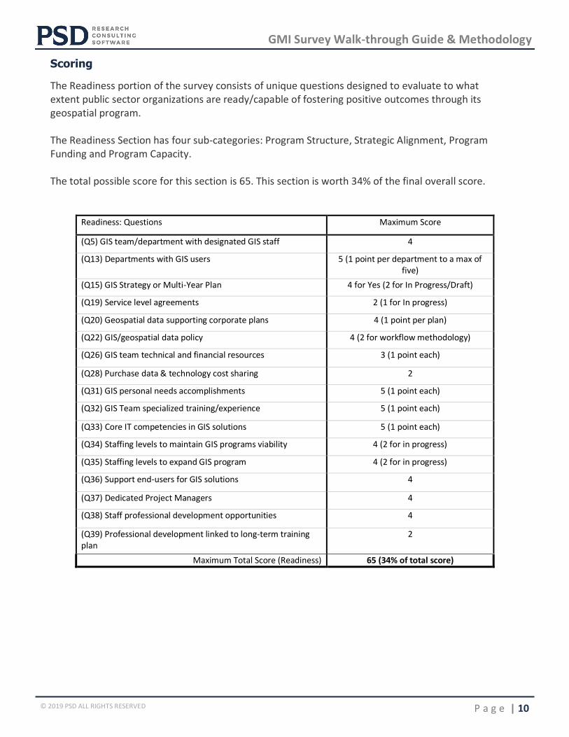
Scoring
The Readiness portion of the survey consists of unique questions designed to evaluate to what extent public sector organizations are ready/capable of fostering positive outcomes through its geospatial program. The Readiness Section has four sub-categories: Program Structure, Strategic Alignment, Program Funding and Program Capacity. The total possible score for this section is 65. This section is worth 34% of the final overall score.
Readiness: Questions Maximum Score
(Q5) GIS team/department with designated GIS staff 4
(Q13) Departments with GIS users 5 (1 point per department to a max of five)
(Q15) GIS Strategy or Multi-Year Plan 4 for Yes (2 for In Progress/Draft)
(Q19) Service level agreements 2 (1 for In progress)
(Q20) Geospatial data supporting corporate plans 4 (1 point per plan)
(Q22) GIS/geospatial data policy 4 (2 for workflow methodology)
(Q26) GIS team technical and financial resources 3 (1 point each)
(Q28) Purchase data & technology cost sharing 2
(Q31) GIS personal needs accomplishments 5 (1 point each)
(Q32) GIS Team specialized training/experience 5 (1 point each)
(Q33) Core IT competencies in GIS solutions 5 (1 point each)
(Q34) Staffing levels to maintain GIS programs viability 4 (2 for in progress)
(Q35) Staffing levels to expand GIS program 4 (2 for in progress)
(Q36) Support end-users for GIS solutions 4
(Q37) Dedicated Project Managers 4
(Q38) Staff professional development opportunities 4
(Q39) Professional development linked to long-term training plan
2
Maximum Total Score (Readiness) 65 (34% of total score)
GMI Survey Walk-through Guide & Methodology
P a g e | 11 © 2019 PSD ALL RIGHTS RESERVED
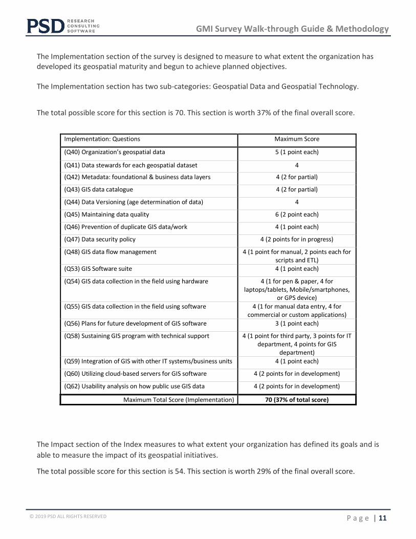
The Implementation section of the survey is designed to measure to what extent the organization has developed its geospatial maturity and begun to achieve planned objectives. The Implementation section has two sub-categories: Geospatial Data and Geospatial Technology.
The total possible score for this section is 70. This section is worth 37% of the final overall score.
Implementation: Questions Maximum Score
(Q40) Organization’s geospatial data 5 (1 point each)
(Q41) Data stewards for each geospatial dataset 4
(Q42) Metadata: foundational & business data layers 4 (2 for partial)
(Q43) GIS data catalogue 4 (2 for partial)
(Q44) Data Versioning (age determination of data) 4
(Q45) Maintaining data quality 6 (2 point each)
(Q46) Prevention of duplicate GIS data/work 4 (1 point each)
(Q47) Data security policy 4 (2 points for in progress)
(Q48) GIS data flow management 4 (1 point for manual, 2 points each for scripts and ETL)
(Q53) GIS Software suite 4 (1 point each)
(Q54) GIS data collection in the field using hardware 4 (1 for pen & paper, 4 for laptops/tablets, Mobile/smartphones,
or GPS device)
(Q55) GIS data collection in the field using software 4 (1 for manual data entry, 4 for commercial or custom applications)
(Q56) Plans for future development of GIS software 3 (1 point each)
(Q58) Sustaining GIS program with technical support 4 (1 point for third party, 3 points for IT department, 4 points for GIS
department)
(Q59) Integration of GIS with other IT systems/business units 4 (1 point each)
(Q60) Utilizing cloud-based servers for GIS software 4 (2 points for in development)
(Q62) Usability analysis on how public use GIS data 4 (2 points for in development)
Maximum Total Score (Implementation) 70 (37% of total score)
The Impact section of the Index measures to what extent your organization has defined its goals and is
able to measure the impact of its geospatial initiatives.
The total possible score for this section is 54. This section is worth 29% of the final overall score.
GMI Survey Walk-through Guide & Methodology
P a g e | 12 © 2019 PSD ALL RIGHTS RESERVED
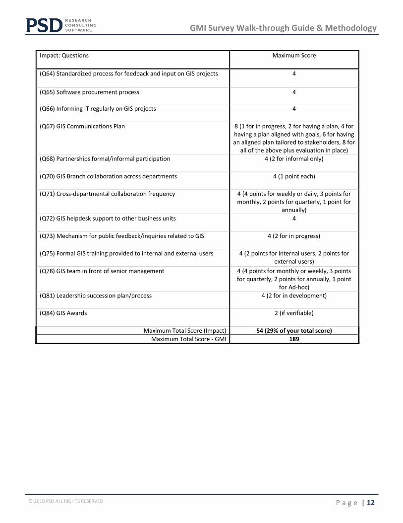
Impact: Questions Maximum Score
(Q64) Standardized process for feedback and input on GIS projects 4
(Q65) Software procurement process 4
(Q66) Informing IT regularly on GIS projects 4
(Q67) GIS Communications Plan 8 (1 for in progress, 2 for having a plan, 4 for having a plan aligned with goals, 6 for having an aligned plan tailored to stakeholders, 8 for
all of the above plus evaluation in place)
(Q68) Partnerships formal/informal participation 4 (2 for informal only)
(Q70) GIS Branch collaboration across departments 4 (1 point each)
(Q71) Cross-departmental collaboration frequency 4 (4 points for weekly or daily, 3 points for monthly, 2 points for quarterly, 1 point for
annually)
(Q72) GIS helpdesk support to other business units 4
(Q73) Mechanism for public feedback/inquiries related to GIS 4 (2 for in progress)
(Q75) Formal GIS training provided to internal and external users 4 (2 points for internal users, 2 points for external users)
(Q78) GIS team in front of senior management 4 (4 points for monthly or weekly, 3 points for quarterly, 2 points for annually, 1 point
for Ad-hoc)
(Q81) Leadership succession plan/process 4 (2 for in development)
(Q84) GIS Awards 2 (if verifiable)
Maximum Total Score (Impact) 54 (29% of your total score)
Maximum Total Score - GMI 189