Embed Size (px)
Citation preview

Chapter 2
Formalizing Geosimulation withGeographic Automata Systems (GAS)
2.1 Cellular Automata and Multiagent Systems—Unite!
Geosimulation requires a genuinely geographic framework for modeling urban systems,
one as formulated on the basis of objects located in space. Ideally, such an approach
would allow for simulated geographic entities to be specified as automata; moreover,
Cellular Automata (CA) and Multiagent Systems (MAS) concepts could ideally be
combined by considering collections of interacting geographic automata. In this chapter,
we introduce such a framework, which considers geographic objects, interacting to form
Geographic Automata Systems (GAS) and urban phenomena as a whole are considered as
the outcomes of collective dynamics among multiple animate and inanimate geographic
automata.
2.1.1 The Limitations of CA and MAS for Urban Applications
Cellular Automata (CA) or Multiagent Systems (MAS) formalisms are already tantaliz-
ingly close to fulfilling the requirements of geosimulation. Applied in isolation, CA and
MAS approaches have been used to simulate a wide variety of urban phenomena
(O’Sullivan and Torrens, 2000; Torrens, 2002; Benenson and Torrens, 2004). Never-
theless, the amalgamation of CA and MAS tools for urban simulation necessitates certain
awkward methodological compromises and most combined CA–MAS computer environ-
ments and applications exploit a strict CA view of the geographic systems that they model.
Either CA cells are granted some degree of agency in their state descriptions and are
# 2004 John Wiley & Sons, Ltd ISBN: 0-470-84349-7Geosimulation: Automata-based Modeling of Urban Phenomena. I. Benenson and P. M. To r r e n s
simply reinterpreted as artificial agents (Box, 2001) and/or MAS are imposed on top of
CA and simulated agents are interpreted as responding to averaged cell conditions
(Portugali, 2000; Polhill et al., 2001). While these frameworks are certainly useful,
they are based on pragmatic rather than theoretical considerations: the combination of CA
and MAS in this manner is a function of the limitations of the available tools rather than
being informed by knowledge or theory regarding how real urban systems function in
space.
From the geosimulation point of view, a reliance on CA cells as the basis for defining
space and spatial interaction is superfluous, and a reliance on regular partitions of space
(Figure 2.1a) can be regarded as a weakness for urban applications of CA; not all
urban spaces are regular in their delineation. The assumption of regularity is largely
superficial, however, and CA have been implemented on a variety of nonregular
tessellations: arbitrary networks (Figure 2.1b), irregular partitions or Voronoi tessellations
(Figure 2.1c) (Semboloni, 2000b; Shi and Pang, 2000; O’Sullivan, 2001; Benenson et al.,
2002). In this case, the form of the neighborhood and the number of neighbors varies
between automata in the CA. An assortment of definitions of neighborhoods, based on
connectivity, adjacency, or distance can be applied to these generalized CA.
Another more important weakness of the CA approach is the inability of automata cells
to move within the lattice in which they reside. Despite repeated attempts to interpret
units’ mobility (Portugali et al., 1994; Schonfisch and Hadeler, 1996; Wahle et al., 2001),
the genuine inability to allow for automata movement in the CA framework catalyzed
geographers’ recent interest in MAS. This tendency is especially strong in urban
geography, where the CA framework is regarded as insufficient in dealing with mobile
objects such as pedestrians, migrating households, or relocating firms.
The main geographic advantage of agent automata lies in their ability to transmit
information by themselves, moving to another location, which can be at any distance from
an agent’s current position. Agents’ spatial behavior can manifest more complex
forms than simple relocation. For example, landlord agents might perform spatially
mediated sale and purchasing of real estate; the spatial behavior of agents designed to
represent car drivers could include the choice of links and turning opportunities at
junctions, etc.
Generally, agent automata employed in social science research (Epstein, 1999; Kohler,
2000) are used to represent individual decision-makers (or, sometimes, groups of
decision-makers). Consequently, the states that are attributed to agent automata are
usually designed to represent socioeconomic characteristics, and agent transition rules
commonly correspond to human-like behaviors. For the most part, however, work in
agent-based simulation in the social sciences outside geography is non-spatial in nature,
as are the tools that are used. There is a compelling justification for developing MAS
that are flexible enough to describe the sorts of spatial behaviors and interactions
mentioned in the previous paragraph. Many of the decisions and behaviors of geographic
agents are spatial in nature, and this distinguishes agent tools used in geographic
applications.
Intuitively, we might identify several geographic mechanisms that are essential to
simulating an urban system:
- A typology of entities;
- The space in which they are situated;
22 Geosimulation: Automata-based Modeling of Urban Phenomena
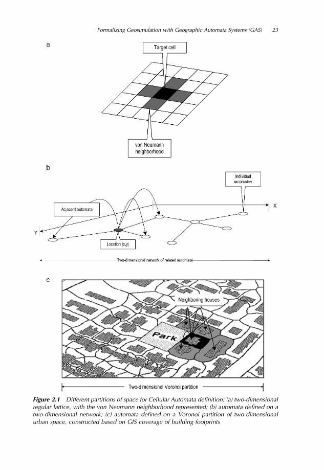
Figure 2.1 Different partitions of space for Cellular Automata definition: (a) two-dimensionalregular lattice, with the von Neumann neighborhood represented; (b) automata defined on atwo-dimensional network; (c) automata defined on a Voronoi partition of two-dimensionalurban space, constructed based on GIS coverage of building footprints
Formalizing Geosimulation with Geographic Automata Systems (GAS) 23

- The spatial relationships between entities;
- The processes governing the changes of entities’ characteristics; and
- The processes governing the changes of their location in space.
Simulating such a system, then, involves explicit formulation of all these five components.
Neither CA nor MAS can fully provide these requirements in isolation. The geography
of the CA framework is problematic for urban simulation because CA are incapable of
representing autonomously mobile entities. MAS are weak as a single tool because of the
generality of the concept and the broad problem that existing MAS tools and methodo-
logies still underestimate the importance of space and relocation behavior. In many cases,
the simulated entities represented by CA and MAS models do not behave as we
understand they should, largely because the modeling framework will not permit them to.
2.1.2 The Need for Truly Geographic Representations in Automata Models
Despite the widely acknowledged suitability of automata tools for geographic modeling
(Gimblett, 2002), there has been relatively little exploration into the development of
patently spatial automata tools for urban simulation. This is partly due to the history of
automata development. The idea of abstract automata dates to Alan Turing’s work on
Turing Machines in the 1930s (Levy, 1992). The CA framework was popularized by John
von Neumann and Stanislaw Ulam in the 1950s during the development of the first digital
computers (Levy, 1992), and the idea of connected and interacting spatial units was
developed by Norbert Wiener’s work on cybernetics (Wiener, 1948/1961). Originally, CA
were pioneered for the description of networks of units influencing each other by means of
signals transferred along links. These networks were used as an abstraction of several
phenomena: universal computational devices, neural networks, the human brain, cellular
tissue, ecological webs, etc. Interest in CA remained obscure for two decades after these
initial developments, until interest was revived by the popularity of John Horton
Conway’s Game of Life (Gardner, 1970, 1971), as well as many applications in physics,
chemistry, biology, and ecology (Wolfram, 2002).
However, the introduction of automata tools in geography is a relatively recent
phenomenon. It took geography, as a discipline, a further 20 years to adopt the concept,
long after automata research had permeated other fields. Despite direct analogies between
land parcels and cells on the one hand and land-uses and cell states on the other,
geographical applications of CA models were few and far between. A few sound examples
published in the 1970s (Chapin and Weiss, 1968; Albin, 1975; Nakajima, 1977; Tobler,
1979) were nonetheless ignored, before interest was revived in the 1980s (Couclelis,
1985; Phipps, 1989). However, it was not until the 1990s that CA modeling became a
widespread research activity in geography, popularized by applications in urban geogra-
phy (Batty, Couclelis, and Eichen, 1997; O’Sullivan and Torrens, 2000).
The study of MAS has taken place much more recently than that of CA. Human-based
interpretations of MAS have their foundation in the work of Schelling and Sakoda
(Schelling, 1969, 1971, 1974, 1978; Sakoda, 1971). Just as with CA, the tool began to
feature prominently in the geographical literature only in the mid-1990s (Portugali et al.,
1997; Sanders et al., 1997; Benenson, 1999; Dijkstra et al., 2000), following its
introduction in ecology and economics at the end of the 1980s (De Angelis and
24 Geosimulation: Automata-based Modeling of Urban Phenomena

Gross, 1992; Tesfatsion, 1997). Until recently, the mainstream of MAS research in
geography involved populating regular CA with agents of one or several kinds, which
could migrate between CA cells, or simply reinterpreting CA as agent-based models, by
attributing anthropomorphic state variables to cells. Often, it is assumed that agents’
migration behavior depends on the properties of neighboring cells and neighbors (Epstein
and Axtell, 1996; Benenson, 1998; Portugali, 2000). Very recent explicit agent-based
models locate agents in relation to real-world geographic features, such as houses or
roads, the latter stored as GIS layers (Benenson et al., 2002) or landscape units—
pathways and view points (Gimblett, 2002). These models clearly demonstrate the
potential of MAS for modeling the intricacies of human spatial behavior.
As a spatial science, geography concerns itself with the behavior and distribution of
objects in space. In urban geography, these are necessarily urban objects—households,
pedestrians, vehicles—and urban features—land parcels, shops, roads, sidewalks, etc. In
dynamic spatial systems, all these objects change their properties and/or location; the goal
of a geographic model is to mimic these activities and their consequences, often at
multiple scales. In the discussion that follows, we present a framework that aims to infuse
spatial properties into automata tools. The framework adopts an object-based and
explicitly spatial view of urban systems. It assumes that urban objects—agents and
features—are all individual automata and, as characteristic of automata, their rules of
behavior can be defined a priori. Urban objects are also conceptualized as geographic
automata, with focus on their spatial properties and behaviors. Under this framework, a
city system can be modeled as a collection of geographic automata, as a Geographic
Automata System.
2.2 Geographic Automata Systems (GAS)
The Geographic Automata System (GAS) framework unites CA and MAS formalisms in
such a way as to directly reflect a geographic and object-based—more specifically,
automata-based—view of urban systems. However, this necessitates a re-working of the
automata idea to incorporate the five essential components mentioned in Section 1 of this
chapter.
2.2.1 Definitions of Geographic Automata Systems
We consider a distinct class of automata, Geographic Automata Systems (GAS), as
consisting of geographic automata of various types. In general, automata are characterized
by states and transition rules. In the case of geographic automata, we also introduce
functionality to enable the explicit consideration of space and spatial behavior. In CA,
pre-defined partitions are often used as a proxy for geography. The approach that we adopt
with GAS differs; instead of pre-defined partitions, we introduce an independent set of
geo-referencing rules for situating geographic automata in space. Likewise, we define
neighborhood rules, rather than relying on fixed neighborhood patterns that are incapable
of being varied in space or time once delineated. Considering the mobile functionality
introduced by the agent-based paradigm, we also consider a set of independent movement
rules that allow for the independent navigation of geographic automata in their simulated
environments.
Formalizing Geosimulation with Geographic Automata Systems (GAS) 25

Formally, a Geographic Automata System (GAS), G, may be defined as consisting of
seven components:
G � ðK; S; TS; L; ML; N; RNÞ ð2:1Þ
Here, K denotes a set of types or ontologies of automata featured in the GAS and three
pairs of symbols denote the rest of the components noted in Section 1 of this chapter, each
representing a specific spatial or non-spatial characteristic and the rules that determine its
dynamics.
The first pair denotes a set of states S, associated with the GAS, G consisting of subsets
of states Sk of automata of each type k2K, and a set of state transition rules TS, used to
determine how automata states should change over time. The second pair represents
location information. L denotes the geo-referencing conventions that dictate the location
of automata in the system and ML denotes the movement rules for automata, governing
changes in their location. According to general definition (1.1) and (1.2) of Chapter 1,
state transitions and changes in location for geographic automata depend on automata
themselves and on input (I), given by the states of neighbors. The third pair in (2.1)
specifies this condition. N represents the neighbors of the automata and RN represents the
neighborhood rules that govern how automata relate to the other automata in their vicinity.
General automata can be easily specified in terms of the framework laid out above. If
the state of a geographic automaton, G, at time t is St, and the automaton is located at Lt,
then external input, It, is defined by its neighbors Nt. The state transition, movement, and
neighborhood rules—TS, ML, and RN —define G’s state, location, and neighbors at time
t þ 1. To animate, or spatially enable the GAS, the following rules are applied to each of
its automata:
TS: ðSt; Lt; NtÞ ! Stþ1
ML: ðSt; Lt; NtÞ ! Ltþ1
RN: ðSt; Lt; NtÞ ! Ntþ1
ð2:2Þ
Exploration with GAS then becomes an issue of qualitative and quantitative investigation
of the spatial and temporal behavior of G, given all of the components defined above. In
this way, GAS models offer a framework for considering the spatially enabled interactive
behavior of elementary geographic objects in a system.
2.2.1.1 Geographic Automata Types
As mentioned, GAS may be composed of automata of different types or ontologies. At an
abstract level, we can distinguish between fixed and non-fixed geographic automata. Fixed
geographic automata represent objects that do not change their location over time and thus
have close analogies with CA cells. For example, in the context of urban systems, a
variety of urban objects may be specified as fixed geographic automata: road links,
building footprints, parks, etc. Fixed geographic automata may be subject to any of the
transition rules outlined already, except rules of motion, ML. Non-fixed geographic
automata symbolize entities that change their location over time. The full range of
rules for GAS can be applied to non-fixed geographic automata, including movement
rules. Typical examples of non-fixed urban automata include pedestrians, vehicles, and
householders (Figure 2.2).
26 Geosimulation: Automata-based Modeling of Urban Phenomena

Any piece of an urban system usually contains objects of both fixed and non-fixed type.
For example, in a GAS model of housing dynamics, apartments and houses might be
represented by fixed geographic automata, with state variables describing several of their
characteristics that are important for residential choice: number of rooms, floor level,
value, architectural style, the year of establishment, presence of elevators, etc. Non-fixed
geographic automata in the GAS model might represent households, with state variables
including economic status of a family, mean age of parents, and number of children.
The characteristics of fixed and non-fixed automata often depend on each other. For
example, the value of an apartment depends on the real estate in the property and
property’s neighborhood and on the population of the neighborhood.
2.2.1.2 Geographic Automata States and State Transition Rules
As with the general automata discussed in earlier sections and the previous chapter, a
variety of state variables S may be assigned to the individual geographic automata that
comprise a GAS, and these states describe the characteristics of the automata in that
system. Any variable can be used to derive state values, including variables of geographic
significance: height, accessibility, visibility, etc. In the case of non-fixed automata, state
variables of relevance to the movement rules of the system may be introduced, for
example, heading, speed, progress toward destination.
State transition rules TS are based on geographic automata of all types from K. It is
worth mentioning that, in the context of the GAS framework, CA are artificially closed,
simply because cell state transition rules are driven only by cells. In contrast, the states
of urban infrastructure objects represented by means of geographic automata depend
on the neighboring objects of the infrastructure, but are also driven by non-fixed
geographic automata—agents—that may be responsible for governing object states
such as land-use, land value, etc. In this way, urban objects do not simply mutate
(O’Sullivan and Torrens, 2000); rather, state transition is governed by all relevant objects.
This is a crucial concept for simulating human-driven urban systems, in which people
interact and are affected by their environments.
For example, a transition rule, Tvalue_update 2 TS, that describes the change in value of
real estate in the model should depend on the states of the real estate objects and, more
importantly, on various attributes of the households that occupy them. In terms of (non-
fixed) householder geographic automata, a transition rule Teconomic_update 2 TS, describing
Figure 2.2 An urban system represented as a set of layers of objects of different types
Formalizing Geosimulation with Geographic Automata Systems (GAS) 27

changes in the economic status of a householder could be defined. Similarly, we could
specify a rule, Mhouseholder_locate 2 ML, describing the way households change their
residence, and Mhouseholder_neighbor 2 RN, describing how householders’ neighbors are
determined.
2.2.1.3 Geographic Automata Spatial Referencing and Migration Rules
Geo-referencing conventions L govern how geographic automata should be registered in
space. For fixed geographic automata, geo-referencing is a straightforward process
in most instances; these automata can be geo-referenced by recording their position
coordinates. However, for non-fixed geographic automata, geo-referencing is dynamic;
automata may move and this demands specific conventions. Also, their location in relation
to other automata, represented in simulated goals, destinations, opportunities, etc., may be
dynamic in space and time. It is also worth noting that there are instances in which geo-
referencing is dynamic for fixed geographic automata also, for example, when land parcel
objects are sub-divided during simulation.
Formally, we say that automata in a GAS can be geo-referenced to simulated spaces
directly and indirectly (Figure 2.3).
Fixed geographic automata are usually located by means of direct geo-referencing.
Direct methods of geo-referencing follow a vector GIS approach, using coordinate lists.
Such a list indicates all spatial details necessary to represent an object—automata
boundaries, centroids, nodes’ location, etc. The details of the particular rules depend on
the automata employed in a modeling exercise. For typical urban objects such as buildings
or street segments, 2D footprint polygons or 3D prisms may be used to register objects in
space. Varying resolutions may be employed, depending on the model application. For
example, when modeling housing dynamics at a ‘‘microscopic’’ scale, data such as
building perimeter, outer borders, and road segments may be required (Figure 2.4a).
However, in other cases, this amount of detail may not be needed and the centroid of a
building and centerlines of road segments may be enough to register automata in the
model (Figure 2.4b). In abstract models, cell-based approximations may suffice
(Figure 2.4c).
The second method by which geographic automata might be geo-referenced, indirectly,
is by pointing to other automata. For example, in the instance of a model of property
Figure 2.3 Direct and indirect geo-referencing of fixed and non-fixed GA
28 Geosimulation: Automata-based Modeling of Urban Phenomena

dynamics, we can geo-reference householders by address (Figure 2.5a). Landlords
provide a more complex example: they can be geo-referenced by their home addresses,
but also by pointing to the properties that they own (Figure 2.5b).
Indirect referencing, by pointing, is mostly relevant for non-fixed geographic automata,
but can also be used for fixed geographic automata, for example, for apartments in a house
(Torrens, 2001). Indirect geo-referencing is convenient for dynamic modeling, with
references varying as a simulation evolves. There is a growing volume of research
into geo-referencing formalisms, particularly associated with location-based services
(Goodchild, 2001).
The movement rule-set, ML, is important for the specification of non-fixed automata
and GAS-based research into different formulations of ML offers great potential for
geographic inquiry. Particularly in terms of urban simulation, automata-based models
have most often been formulated as CA. Even when cells are used to encode movement-
like behaviors, as is often the case in traffic models, transition rules are used to mimic
movement (Portugali et al., 1994; Schonfisch and Hadeler, 1996), rather than representing
the motion of traveling objects as vehicles, pedestrians, householders, institutions, etc. in
real urban systems. In other areas of research, realistic rules, ML, for encoding automata
movement, based on repel–attract–synchronize interactions between close neighbors, are
being developed, for example, in Animat research (Meyer, 2000) and in the gaming
industry (Reynolds, 1999). There is much opportunity for geographers to contribute to this
Figure 2.4 Direct geo-referencing. (a) Buildings are represented by means of foundationcontours; road segments by means of road boundaries. (b) Buildings are represented by meansof foundation centroids; road segments by means of a road segment centerline. (c) Buildingcentroids and roads are represented by cells
Figure 2.5 Indirect geo-referencing by pointing. (a) Locating householder agents by pointingto the houses they occupy. (b) Locating a landowner agent by pointing to its properties
Formalizing Geosimulation with Geographic Automata Systems (GAS) 29

line of research. Traditionally, attention has focused on the generation of realistic
choreographies for automata, particularly in traffic models, through the specification of
rules for collision avoidance, obstacle negotiation, lane-changing, flocking, behavior at
junctions, etc. (Torrens, 2004). However, there remain many relatively neglected areas of
inquiry: spatial cognition, migration, way-finding, navigation, etc.
2.2.1.4 Geographic Automata Neighbors and Neighborhood Rules
Another component of GAS that needs explicit definition is the set of neighbors of
automata, N, and the rule set for determining the change in neighborhood relationships
between automata, RN. The set of neighbors of different types is necessary for the
application of transition rules TS (state transition) and ML (movement), which depend on
properties of geographic automata and their neighbors. In contrast to the static and
symmetrical neighborhoods employed in traditional CA models (Figure 2.1a), spatial
relationships between geographic automata vary in space (Figure 2.1b,c) and time, and,
thus, RN rules should be formulated in such a way as to account for geographic automata
locations neighbors at each time step in a model’s evolution.
Neighborhood rules for fixed geographic objects are relatively easy to define (simply
because the objects are static in space). There are a variety of geographical ways in which
neighborhood rules N can be expressed for them—via adjacency of the units in regular or
irregular tessellations, connectivity of network nodes, proximity, etc. Similarly, other
spatial notions of neighborhood, related to the incorporation of human-like automata into
GAS, such as accessibility, visibility, and mental maps can be formally encoded as RN
rules.
Non-fixed geographic automata pose more of a challenge when specifying neighbor-
hood rules, because the objects—and hence their neighborhood relations—are dynamic in
space and time. It can be done straightforwardly, via distance and nearest-neighbor
relations, as used in Boids models (Reynolds, 1987), but can become very heavy
computationally when more complex definitions of visibility or accessibility are involved.
In this case, it is more appropriate to base neighborhood rules on indirect location, as
defined in the sections above, and consider two indirectly located automata as neighbors
when the automata they point to are neighbors.
For example, in Figure 2.6, two householder agents are established as neighbors by
assessing the neighborhood relationship between the houses in which they reside.
Figure 2.6 Definition of neighboring relations for indirectly located geographic automata.Two householders are neighbors if they are located in the same property or in neighboringproperties
30 Geosimulation: Automata-based Modeling of Urban Phenomena

2.2.2 GAS as an Extension of Geographic Information Systems
GAS have strong affiliations with Geographic Information Systems (GIS). Indeed,
re-formulation of automata tools as GAS opens up some exciting opportunities for
tightly-coupling automata, Geographic Information Science (GISci.), and GIS. On a basic
level, GIS is the natural environment for preparing and visualizing GAS models.
Advancing further, GAS are based on the ability of GIS to register data spatially, and
to use spatial analysis to shape data as layers of entity-level objects and to estimate
relationships between them (Torrens and Benenson, 2005).
2.2.2.1 GAS as an Extension of the Vector Model
Geographic automata models are tightly bound to vector GIS (Figure 2.1).
First, geographic automata of many types correspond to GIS features, which can be
used to derive automata location. For fixed geographic automata, it is done directly, by
using the coordinate representation of a corresponding GIS feature.
Second, the majority of relationships between geographic automata can be naturally
evaluated within vector GIS: standard overlay operators such as point-in-polygon,
buffering, intersection, etc., make it possible to determine how automata are situated in
relation to other automata. More specifically, neighborhood rules are readily available for
evaluating adjacency, contiguity, continuity, distance, accessibility, visibility, and so on.
Third, and as mentioned, GIS are an excellent tool for visualizing and querying the
outcomes of GAS simulations.
Finally, recent advances in GIS technology guarantee a functional GIS background for
potential GAS computational environments. A number of GIS libraries can be interfaced
with other software through the Component Object Model (COM) (Microsoft Corporation
and Digital Equipment Corporation, 1995; Ungerer and Goodchild, 2002) or technologies
such as JavaBeansTM (Sun Microsystems, 2002).
However, in many ways, GAS move far beyond vector GIS, just as CA models go far
beyond raster GIS. First, this relates to GAS object types—GIS features do not cover all
the variety of geographic automata types. Landlords, as part of housing GAS, are a typical
example of this kind: their own location might not be important for the model, while the
location of the real estate that they possess really is. Consequently, the location of
landlords in such a housing model should be implemented by pointing to real estate
holdings. Second, GAS are dynamic, while GIS are not. The essence of GAS is in the rules
of state, location, and neighborhood transitions: TS, ML, RN, which do not have analogies
in GIS; GIS would benefit from the introduction of automata-like functionality.
Indeed there are opportunities to extend regular vector GIS, especially open source GIS
(Baylor University, 2002; Centre for Computational Geography, 2003) toward GAS;
recent raster GIS extensions to CA provide a proof-of-concept for such development
(Clark Labs, 2002).
2.2.2.2 GAS and Raster Models
While GAS have obvious affiliations with vector GIS; they are also functionally
connected to raster GIS in several ways. Each pixel of a raster layer can be regarded,
at least morphologically, as an automata cell, geo-referenced by column and row positions
Formalizing Geosimulation with Geographic Automata Systems (GAS) 31

within a GIS scene. Based on these coordinates, one can easily consider a pixel-cell as a
point or square feature of vector GIS, and the latter fully enable vector GIS functionality,
including estimation of relations between objects. Nonetheless, the conceptual difference
between features originating from cells of raster and features of vector GIS layers still
remains; the latter are normally chosen to represent real-world objects, while the former
are not. The choice of a raster or vector view is beyond the GAS scheme and evidently
depends on the goal of a model. Irregular tessellations based on land partition fit naturally
into real-world simulations, while raster representations essentially simplify neighbor-
hood definitions and other relationships.
2.3 GAS as a Tool for Modeling Complex Adaptive Systems
Urban systems are widely regarded as complex adaptive systems (Portugali, 2000); GAS
offer much potential for simulating their various properties, their spatial attributes in
particular. GAS models of urban systems are built as collectives of interacting geographic
automata and these interactions may be specified in such a way that they facilitate the
emergence of higher-level entities, phenomena, and events, from the bottom-up. Complex
systems exhibit self-organization phenomena—emergence, bifurcations, catastrophes—
and GAS models can be used to reflect phases of continuous quantitative development in
urban systems as well as recognizing and modeling possible abrupt and qualitative
changes in their dynamics. The relevance of GAS to applications of complex system
theory is geographic in nature; the focus in GAS models is, primarily, on investigating
self-organization in space.
Spatial systems can self-organize in two ways, and this reflects the aforementioned
dichotomy of fixed and non-fixed objects encapsulated in the GAS framework. First, fixed
elements can change their properties in a way that entails emergence of assembled spatial
objects or the dissolution of existing ones; models of voting are an obvious example
(Stauffer, 2001). Second, the same can happen when non-fixed elements change not only
their properties, but also their locations, as in residential dynamics models initiated by
Schelling and Sakoda (Schelling, 1969, 1971, 1974, 1978; Sakoda, 1971). The alteration
of states and locations is an especially important consideration in geographic automata
that represent human individuals. The behavior of the latter is essentially based on the
ability to recognize emergence or, in the opposite instance, disintegration among
ensembles of objects (as, for example, concentration of householders in particular
groups). These abilities can be formally considered as positive feedbacks, which
accelerate or decelerate the self-organization processes in urban systems.
2.4 From GAS to Software Environments for Urban Modeling
2.4.1 Object-Oriented Programming as a Computational Paradigm for GAS
Operationally, geosimulation modeling is ‘‘Simulation of GAS.’’ Any geosimulation
environment should therefore provide functionality for the representation of all three
GAS components defined in Section 2 of this chapter: to implement and locate urban
objects; to determine neighborhood and other spatial relationships between them; and to
32 Geosimulation: Automata-based Modeling of Urban Phenomena

formulate state transition, migration, and neighborhood rules. The Object-Oriented
Programming (OOP) paradigm provides an excellent framework for facilitating these
sorts of representations, and, furthermore, allows for the depiction of single automata and
collectives of automata in a relatively seamless manner. In what follows, we concentrate
on the logic of the GAS implementation as a OOP simulation environment framework,
discussing abstract software classes that form the logical core of such a software
environment; for the most part, we ignore issues such as implementing specific models,
user interfaces, performance, data storage, visualization, etc.
2.4.2 From an Object-Based Paradigm for Geosimulation Software
Any simulation software environment must come equipped with some clear determination
of its own position between the extremes of abstract concepts and rigid formalizations.
Ideally, an environment for geosimulation should be ‘‘open,’’ as open as the concepts of
urban dynamics it is used to simulate. However, the greater the freedom afforded to the
user, the lower the potential benefit to be gleaned from specialized simulation software.
General-purpose programming languages implemented within user-friendly OOP devel-
opment environments—such as Java, VB. Net, Delphi, Cþþ or C#—are standard tools,
always at hand and directly ‘‘under user control.’’ Simulation environments based on
predetermined formalization of laws of system dynamics promise significant reduction of
development time; however, as a tool, those environments are invariably bound to the laws
of system dynamics, as well as specific kinds of data. The software cooperates only if you
ask it to, in the right way, and feed it the right data snacks. The assumptions of the
underlying concept also constrain the tool, functionally. Invariably, there is significant
overhead in terms of learning time and more often than not this is accompanied by a level
of anxiety, on the part of the user, related to discovering that something ‘‘does not fit,’’ too
late in the process.
Simulation practitioners are aware of this, and there is a relatively recent trend or shift
toward favoring development environments that support specific concepts of the system in
question. Where software is based on automata concepts, the resulting environments are
generally quite extensible in functional terms. We follow this line of reasoning, and assert
that two fundamental features of a software environment for geosimulation should be as
follows:
(a) Openness for different formalizations of objects’ behavior, provided that the user
accepts a GAS-based view of the system;
(b) Users’ full responsibility for the formalizations’ correctness.
This sort of view has already been realized in some popular agent-based simulation
environments. The first such environment to enjoy popular use was SWARM, followed by
SWARM-based systems such as MAML (Gulyas et al., 1999) and EVO (Krumpus, 2001).
The new kid to the block is Repast (RePast, 2003), which was developed from scratch,
around a SWARM-like conceptual framework.
Geosimulation is a modeling paradigm and its realization is bound to concept-oriented
software. We argue that a reference to urban systems is sufficient to specify a universal
object-oriented paradigm in a way that facilitates ‘‘object-conversant’’ students of urban
studies in formalizing and studying the dynamics of urban phenomena through simula-
tion-based experimnentation and exploration. Let us demonstrate what we mean.
Formalizing Geosimulation with Geographic Automata Systems (GAS) 33

2.4.3 GAS Simulation Environments as Temporally Enabled OODBMS
Geosimulation considers urban infrastructure and social objects as spatially located
discrete entities, characterized by several properties, which can be directly interpreted
as software objects. Computer avatars of real-world urban entities comprise only one of
the three basic components of GAS; to reflect the full range of components, the
environment should interpret relationships between entities, and self-organizing ensem-
bles of entities, as software objects.
Vector GIS, to which the GAS approach can be considered as tightly-coupled, points in
the direction of avenues for implementing GAS as software. GIS is an extension of a
relational database, and data storage, updating, querying, and computation within GIS
environments is organized in the framework of the entity-relationship data model (ERM).
The main concept of ERM lies in consideration of real-world objects—entities—
separately from relationships between them. To preserve GIS structure, GAS formalism
should also have a basis in this delineation. OOP and ERM are the cornerstones of Object-
Oriented Database Management Systems (OODBMS) (Booch, 1994); it makes sense that
a ‘‘straightforward’’ geosimulation environment could conveniently rely on OODBMS
logic.
Consideration of OODBMS theory immediately raises a basic problem likely to be
encountered in the development of any geosimulation software environment: generally,
ERM and OOP ideas contradict each other (Booch, 1994)! The source of contradiction is
the absence of a general solution for managing relationships between objects. A range of
partial solutions—software patterns—have been proposed, all of which depend on the
nature of objects and the semantics of their relationships, and one can refer to computer
science publications for complex examples demanding complex solutions (Peckham
et al., 1995). Below we discuss the simplest of patterns; luckily for us, it is nonetheless
sufficient for all geosimulation models we are aware of.
2.4.4 Temporal Dimension of GAS
A basis for fixed and non-fixed objects, and direct and by-pointing locating, implies
specification of Geographic Automata Systems within Object-Oriented GIS. However, the
dynamic nature of GAS also implicates temporal dimensions of GIS databases, and, thus
entails its own limitations. Given these considerations, transition rules TS, ML, and RN,
should be defined in a way that avoids conflicts when states, locations, or neighborhood
relations are created, updated, or destroyed.
A triplet of transition rules determines the states S, locations L, and neighbors N of
automata at time t þ 1 based on their values at time t. It is very well known that different
interpretations of the ‘‘hidden’’—time—variable in a discrete system can critically
influence model formulation and resulting dynamics (Liu and Andersson, 2004). There
are several ways to implement time in a dynamic system. On the one hand, we consider
time as governed by an external clock, which commands simultaneous application of
rules (2.2) to each automaton and at each ‘‘tick’’ of some artificial, simulated clock. On
the other hand, each automaton can have its own internal clock and, thus, the units of time
in (2.2) can have different meaning for different automata. Formally, these approaches are
expressed as synchronous or asynchronous modes of updating of automata states. System
dynamics strongly depend on the details of the mode employed (Berec, 2002).
34 Geosimulation: Automata-based Modeling of Urban Phenomena

2.5 Object-Based Environment for Urban Simulation (OBEUS)—a Minimal
Implementation of GAS
Under GAS, an abstract concept can be formalized in different ways. We assert that GAS
simulation software should be ‘‘down to earth,’’ that is, implementation of an abstract idea
should be appropriate for users who are not programming experts. In what follows, we
describe the Object-Based Environment for Urban Simulation (OBEUS), which has been
developed as a simplest implementation of the GAS concept in a software environment
(Benenson et al., 2004). OBEUS is sufficient for all urban geosimulation models we are
aware of.
There are three categories of classes in the OBEUS scheme: Universal, Model, and
User-defined. Classes that belong to the Universal category are considered as those that
are necessary for simulating any urban process. The Model category of classes inherits
abstract Universal classes and is necessary for specifying any model of a specific class. In
what follows, a model of housing dynamics is considered as an example of such a class.
User-defined classes reflect specificity in users’ models and are constructed anew, if necessary,
in each application. In the discussion that follows, we only focus on abstract classes.
2.5.1 Abstract Classes of OBEUS
OBEUS is a software environment based on a GAS conceptual core. As such, the basic
components of GAS are defined in OBEUS with respect to automata types k 2 K, its states
Sk, location L, and neighborhood relations N to other objects. These are implemented by
means of three abstract root classes:
- Population, which contains information regarding the population of objects of given
type k as a whole;
- GeoAutomata, acting as a container for geographic automata of given type k;
- GeoRelationship, which facilitates specification of (spatial, but not necessarily) rela-
tionships between geographic automata of the same or different types.
Figure 2.7 illustrates the hierarchy of OBEUS abstract classes and their main methods
by means of a UML diagram (Booch et al., 1999).
The location information for geographic automata essentially depends on whether the
object we consider is fixed or non-fixed. This dichotomy is handled using abstract classes,
Estate and Agent. The Estate class is used to represent fixed geographic automata (land
parcels and properties in a residential context). The Agent class represents non-fixed
geographic automata (householders and landlords in a residential context).
Fixed objects are located directly, in a manner similar to vector GIS, that is, by means
of a coordinate list. Features of planar GIS layers or 3D CAD models can represent urban
objects in spatially explicit models. For theoretical models, the points of a regular grid
usually suffice.
Non-fixed urban objects are located by pointing to one or several fixed objects. For
example, householders are located by pointing to their habitats, as it was shown in
Figure 2.5a. Non-fixed urban objects, the location of which is relatively unimportant but
Formalizing Geosimulation with Geographic Automata Systems (GAS) 35

Attr
ibut
e <a
bstr
act>
calc
ulat
e V
alue
():v
oid
getP
rese
ntat
ionC
olor
():C
olor
getO
utpu
tFile
For
mat
():S
trin
g
Con
tinuo
usva
lue:
rea
lD
iscr
ete
valu
e: in
tV
ecto
rva
lue:
Vec
tor
side
A: O
bjec
tsi
deB
: Obj
ect
attr
ibut
e: A
ttrib
ute[
]at
tach
(): v
oid
deta
ch()
: voi
d
getA
ttrib
utes
(): v
oid
upda
teA
ttrib
utes
(): v
oid
Age
ntE
stat
eRel
atio
nge
tTim
eOfC
reat
ion(
):in
t
Ent
ityD
omai
nRel
atio
n
getT
imeO
fCre
atio
n()
getO
ther
Sid
e(O
bjec
t req
uest
or):
Obj
ect
Geo
Rel
atio
nshi
p <a
bstr
act>
attr
ibut
e: A
ttrib
ute[
]up
date
Attr
ibut
es()
:voi
dge
tAttr
ibut
e(in
dex)
:Attr
ibut
e
Geo
Aut
omat
on <
abst
ract
>
Est
ateE
stat
eRel
atio
n
Hou
seH
ouse
getN
umbe
rOfN
BH
ouse
s():
Inte
ger
Hou
seho
lder
Hou
sege
tNum
berO
fNei
gnbo
rs()
:Inte
ger
getM
eanN
BH
Val
ue()
:Attr
ibut
e[]
Val
ue: A
ttrib
ute
upda
teV
alue
():A
ttrib
ute[
]
Hou
seH
ouse
hold
erD
omai
nH
ouse
getD
ista
nceT
oDom
ain(
Hou
seho
lder
D:D
omai
n):R
eal
entit
ies:
Ent
ity[]
loca
tion:
Est
ate
Age
nt <
abst
ract
>
getL
ocat
ion(
):E
stat
ese
tLoc
atio
n():
Est
ate
rela
tedE
stat
es: E
stat
eEst
ateR
elat
ion
Est
ate
<abs
trac
t>
getR
elat
edE
stat
es(P
opul
atio
n)()
:Est
ate[
]
getM
eanN
BR
Sta
tus(
):A
ttrib
ute[
]ec
onom
icS
tatu
s: A
ttrib
ure
calc
ulat
eDis
satis
fact
ion(
):re
al
Hou
seH
olde
r
crite
riaA
ttrib
ute:
Attr
ibut
e[]
Pop
ulat
ion
<abs
trac
t>
upda
teD
omai
n(cr
iteria
, Pop
ulat
ion)
:Dom
ain
entit
ies:
Ent
ity[]
build
Dom
ain(
crite
ria):
void
getD
omai
nEnt
ities
():E
ntity
[]
Geo
Dom
ain
<abs
trac
t>
City
<ab
stra
ct>
getG
ener
alC
onst
rain
ts()
Hou
seho
lder
City
getim
mig
rant
s():
Hou
seho
lder
[]
Hou
seho
lder
Pop
getN
umbe
rOfD
wel
lings
():In
tege
rge
tVac
antH
ouse
s():
Hou
se[]
Hou
seP
op
getP
erim
eter
():r
eal
getA
rea(
):re
al
Hou
seho
lder
Dom
ain
leav
eHou
se(c
riter
ia):
Boo
lean
choo
seH
ouse
(int C
hoic
eHeu
ristic
,Hou
seLi
st[]:
Hou
se):
Hou
sele
aveC
ity()
: Boo
lean
nn
n
nn
11
11
1
Figu
re2.7
Hie
rarc
hy
of
OB
EUS
abst
ract
clas
ses
(tra
nsp
aren
tblo
cks)
and
exte
nsi
on
of
OB
EUS
for
resi
den
tial
dyn
amic
sm
odel
ing
(gra
yblo
cks)

which retains important properties, are related to possessions—fixed objects—by pointing;
for example, landlords point to their properties, as in Figure 2.5b.
Following from this, three abstract relationship classes can be specified: EstateEstate,
AgentEstate, and AgentAgent. The latter is not implemented; the only way of locating
Agents modeled in OBEUS is by pointing to Estates; consequently, direct relationships
between non-fixed objects are not allowed (Figure 2.8). The reasons are nothing but
utilitarian.
First, spatial relations between fixed objects are also fixed after these objects are
established; thus, they can be estimated and updated only when new fixed objects are
created. Second, relationships between non-fixed objects can be easily obtained as a
superposition of relationships of non-fixed–fixed and fixed–fixed type. Third, re-estima-
tion of non-fixed–non-fixed relationships can become unwieldy if many non-fixed objects
change their location simultaneously. All urban models we are aware of can be interpreted
in terms of the fixed–fixed and non-fixed–fixed relationships and a majority of them
accounts for only one, two, or three relationship classes at most.
2.5.2 Management of Time
The OBEUS architecture utilizes both Synchronous and Asynchronous modes of updating
time.
In Synchronous mode, all objects are assumed to change simultaneously. The calling
order of the objects has no influence in this mode, but conflicts arise when agents compete
over limited resources, as in the case of two householders trying to occupy the same
apartment. Resolution, if ever, of these conflicts depends on the model’s context, a
decision OBEUS leaves to the modeler. It is worth noting that the logic of synchronous
updating often passes conflicts further in time. If two mutually avoiding agents occupy
adjacent locations and simultaneously leave them at a given time-step, then in synchro-
nous mode nothing can prevent occupation of these locations by another pair of avoiding
agents.
Figure 2.8 Possibilities of object location in OBEUS
Formalizing Geosimulation with Geographic Automata Systems (GAS) 37

In Asynchronous mode, objects change in turn, with each observing an urban reality as
left by the previous object. Conflicts between objects are thereby resolved; instead, the
order of updating (often, but not necessarily, random) is critical as it may influence results.
OBEUS demands that the modeler define an order of object actions according to several
templates; random sequence, pre-defined sequence, sequence in order of some character-
istic are currently being implemented.
2.5.3 Management of Relationships
Relationships in GAS models can change in time and this might cause conflicts, when, in
housing applications, for example, a landlord wants to sell his property, while the tenant
does not want to leave the apartment. This example represents the general problem of
consistency in managing relationships. It has no single general solution; there are plenty
of complex examples discussed in the computer science literature (Peckham et al., 1995).
In OBEUS, we follow the development pattern proposed by Noble (2000). To maintain a
consistency in relationships, an object on one side, termed the leader, is responsible for
managing the relationship. The other side, the follower, is comprised of passive objects.
The leader provides an interface for managing the relationship, and invokes the followers
when necessary. There is no need to establish leader or follower ‘‘roles’’ in a relationship
between fixed objects once the relationship is established, while, in relationships between
a non-fixed and a fixed object, the non-fixed object is always the leader and is responsible
for creating and updating the relationship. For instance, in a relationship between a
landlord and her property—Figure 2.5b—when ownership cannot be shared, the landlord
initiates the relationship and is able to change it.
Relationships between fixed objects should be initialized when fixed objects are
initiated, and only then retrieved. Relationships between non-fixed and fixed objects are
initiated or eliminated according to requests from the former because they are always
leaders within the relationships.
The distinction between objects and relationships, and employment of the leader–
follower pattern, offers immediate advantages for software applications. For example, it
provides an identical framework for CA and explicit GIS-based land-use models, both of
which are based on neighborhood relationships. For a square CA grid and von Neumann
or Moore neighborhoods, the degree of neighborhood relationship is either 1:4 or 1:8,
while for White and Engelen’s (1993) constrained CA, the degree of neighborhood
relationship is 1:113, based on neighborhoods of radius 6 around the cell. The only
difference between CA models and GIS-based representation of land units based on
Voronoi or other partitions of a plane (Flache and Hegselmann, 2001; Benenson et al.,
2002) is the variation in degree of neighborhood relationship from parcel to parcel, which
is identical for cells in the CA. The distance between the cell and its neighbor, the length
of the common boundary, and other factors, can be considered attributes of a neighbor-
hood relationship object.
The leader and follower should be defined separately for each relationship. In addition
to that consistency, the latter ensures that the algorithm implemented for relationship
updating will result from intentional thought. There is no proof that the majority of real-
world situations can be imitated by the leader–follower pattern, although we are not aware
of any natural instance, in urban models, where this pattern is insufficient.
38 Geosimulation: Automata-based Modeling of Urban Phenomena

2.5.4 Implementing System Theory Demands
Systems theory suggests another challenge for automata modeling in which the usefulness
of the GAS–OBEUS approach appears to offer advantages.
The idea of self-organization is external to GAS and it is not necessary to incorporate it
into software implementation. Nonetheless, self-organization is too often important for
studying urban systems; it cannot be ignored, even at the first step of GAS software
implementation. Emerging spatial ensembles of geographic automata are supported in
OBEUS by means of an abstract class GeoDomain. The simplest approach to emergence,
determined by the set of a priori given predicates defined on geographic automata is
implemented; domains are thus limited to capturing ‘‘foreseeable’’ self-organization of
specific types.
Domains intuitively represent industrial or commercial areas, rich or poor neighbor-
hoods, or areas displaying a specific architectural style. We assume that domains can be
determined by fixed predicates, defined on unitary objects. Let us give an example; the set
of unitary objects DC form a domain, satisfying criterion C if
1. For each d2DC, a sufficient number of d’s neighbors (but not necessarily d itself)
satisfy criterion C;
2. DC contains a sufficient number of unitary objects.
Figure 2.9 presents a simple illustration of ‘‘dark gray’’ domain DC, with criterion C
demanding that ‘‘50% or more of the neighbors within a 3 � 3 Moore neighborhood are
dark gray.’’
The importance of domains for representing urban phenomena is evident. A suburb
containing many expensive apartments is considered an expensive neighborhood; the
value of other real estate in that market consequently increases. One can investigate the
consequences, for the city, of the positive feedback generated by the unsatisfied demand of
wealthy agents who enter the area, buy properties, and subsequently reinforce these areas
as ‘‘expensive’’ domains. Alternatively, an expensive domain can disappear when, for
example, wealthy agents become aware of a nearby polluting factory and migrate out of
Figure 2.9 Illustration of the domain criterion. A cell belongs to ‘‘dark gray’’ domain DC if50% or more of its neighbors within a 3 � 3 Moore neighborhood are dark gray
Formalizing Geosimulation with Geographic Automata Systems (GAS) 39

the area. Another domain criterion may be based on the age of urban objects (e.g., the age
of buildings), an idea utilized in deltatron CA (Clarke, 1997; Candau et al., 2000).
As with non-fixed objects, domains in OBEUS can be related to fixed objects only.
These relationships can capture properties such as distance between unitary fixed objects
and the domain; several definitions of distance based on objects’ and domains’ centroids,
boundaries, etc., can be evidently applied. Analysis of available urban models demands
consideration of domains of fixed as well as non-fixed objects (low-cost dwellings and
poor households, for example).
Domains can always change, which automatically makes them leaders in the relation-
ship with unitary objects. As in the case of non-fixed objects, OBEUS ignores direct
relationships between domains and non-fixed objects or domain-domain relationships.
2.5.5 Miscellaneous, but Important, Details
Some of the properties of an urban system relate naturally to the city as a whole. These
properties concern relationships between populations’ attributes, as, say, the mean number
of apartments in a building. The software class City (Figure 2.7) represents the city as a
whole. The software manages a single instance of the City class, a singleton according to
Gamma et al. (1995).
An abstract class Attribute (Figure 2.7) is not directly related to the idea motivating this
chapter but it is useful and convenient, so we will mention it anyway. In OBEUS,
attributes are typed, and common data types are supported, as are arrays. Attribute arrays
are of the same scalar type so as to support internal comparisons between the array’s
different elements (e.g., different components of householder income).
OBEUS is only one example; many other software systems exist, and several have
rather large and active development and use bases. For the most part, these environments
are mostly aimed at MAS simulations, and some offer GAS-like or close-to-GAS abilities.
Their description is somewhat of a sideline to the discussion relevant to this book. No
doubt any description we could document here will be out-of-date quite quickly; such is
the nature of software development in a quickly growing area.
2.6 Verifying GAS Models
GAS models, as any other models, should be verified, adjusted to a particular system,
place, and time to compare the performance of the model to the properties of the real
system being simulated. Specified by direct application of the object-based view of
geographic reality, geosimulation models are applied in the following sections to a broad
spectrum of urban phenomena, which differ greatly in the level of their abstraction. The
models vary from very abstract description of collectives of objects randomly wandering
over rectangular grids, to detailed quantitative varieties that imitate residential dynamics
in the Yaffo area of Tel-Aviv during the period 1951–1995, at the resolution of separate
buildings.
Geosimulation deals with objects in space and time; consequently, employing it in full,
one could, for example, relate a geosimulation model to time-series of urban 2D maps,
which might represent objects involved in the description of the system or a variety of
40 Geosimulation: Automata-based Modeling of Urban Phenomena
systems that the model talks about. As in the case of any spatial model, to do that, it is
necessary to establish a few things:
(1) Initial conditions—the states of model objects, the coordinate location of fixed
objects, neighborhood relationships and relationships necessary for indirect location
that define the values of S, L, at a zero moment t0 in which the simulation is begun;
(2) Boundary conditions, or, in geographic terms, spatial constraints—the conditions that
should be held during the entire simulation run and;
(3) The values of model parameters, which should be employed to run the simulation
ahead in time—the parameters that specify the rules of state transitions TS, migrations
ML, and neighborhood rules RN.
One of the goals of scientific research is to develop theory that explains the whole
spectrum of phenomena being considered; that is why we are usually interested in as broad
a spectrum of initial conditions, constraints, and parameters as possible—characteristic
of all possible instances of the phenomena we try to explain with the help of the model.
Dataware resources are evidently crucial for this purpose. As discussed in the
introductory chapter of this book, recent progress in development of high-resolution
geographic data supply is significant, and remotely-sensed imagery and GIS databases are
ready for feeding geosimulation models with necessary information (Gimblett, 2002;
Benenson and Omer, 2003; Torrens, 2004b). Quite often, the situation looks close to
ideal—the simulated area is covered with a series of remotely sensed images and/or high-
resolution GIS layers, say, layers of houses and land parcels and images of their use at
different moments in time. Despite progress in this arena, however, a closer view of these
kinds of data invariably reveals some incompleteness, and a number of compromises are
often necessary if the model is to work with the data.
This state of dataware is relatively new, and brings standard technical problems of
verification into the focus of geographic research. A huge general literature on the topic
based mostly on non-geographic examples is at hand (Albrecht et al., 1993; Brown, 1993;
Smith and Kandel, 1993; Roache, 1998), and geography, as a field, should still adopt those
developments. In this section, we will briefly examine examples of validation and verifica-
tion. The issue as a whole will, undoubtedly, be one of the hot topics in future geosimu-
lation research. We will discuss model-specific issues when they occur in later chapters.
2.6.1 Establishing Initial and Boundary Conditions
For explicit models, we can be certain of data demands, while at the same time the
problem of incompleteness in those resources may often need to be addressed. Consider
an example. In a model of Arab-Jewish ethnic residential dynamics in the Israeli city of
Yaffo, developed for simulation of a period spanning from 1951 to 1995 (Benenson
et al., 2002), two high-resolution GIS layers of buildings (with attributes capacity and
architectural style) and road networks (with an attribute width) are used as constraints. In
the model, these layers are constructed in 1995, while applied from the beginning of 1951;
the belief being that the infrastructure did not change very much in that time. The initial
condition demanded in the model is the distribution of Arab and Jewish families at
resolution of separate buildings in 1951, which is unavailable. Those conditions are
Formalizing Geosimulation with Geographic Automata Systems (GAS) 41

constructed in a synthetic way; the population fractions of Arabs and Jews are randomly
distributed over the areas they were assumed to populate in 1951, proportional to
buildings’ capacity for inhabitants. The uncertainty of the population distribution in
1951 should thus be investigated (see Chapter 5).
That was an explicit model; what about abstract models? Abstract models concentrate
on features that are characteristic of many instances of the phenomena being considered.
Let us consider models aimed at explaining the emergence of urban structure as a typical
flavor (Batty and Xie, 1997, 1999; Wu, 1998c; Andersson et al., 2002). Generally, space is
represented in such models as a rectangular grid of points; initially, that space is either
‘‘empty’’ or randomly filled with the objects being considered. The constraints employed
are very general and regard the size, resolution, or form of the grid; investigation through
simulation generally concentrates on self-organization of spatial patterns as a conse-
quence of model rules.
The models we consider in this book cover a spectrum between explicit and abstract
formulation. Discussion in Chapters 4 and 5, devoted to Cellular Automata and
Multiagent Systems, begins with abstract models and proceeds from there in a more
and more specific fashion, toward explicit models; in parallel, initial and boundary
conditions become more and more detailed and more and more real-world data are
employed.
2.6.2 Establishing the Parameters of a Geosimulation Model
The objects of GAS systems change their state, location, and relations with other objects
according to state transition, location, and neighborhood rules. To establish the model the
analytical form of the rules should be provided; when defined, the parameters of the rules
might be estimated based on comparison of model outcomes and real-world data or their
abstraction. As we mentioned above, series of 2D maps or coverages are common output
from geosimulation models, and comparison can be performed according to every
characteristic of these maps.
Of course, there is no substitute for visual comparison, really, in terms of expertise. The
model developer is her own best expert system, especially at initial stages of model
investigation. ‘‘The eye of the human model developer is an amazingly powerful map
comparison tool, which detects easily the similarities and dissimilarities that matter,
irrespective of the scale at which they show up’’ (Straatman et al., 2004). Quantitative
methods of comparison of this nature characterize model maps and real maps and provide
a measure of similarity between them. Visually, we do that simultaneously and implicitly.
Statistical methods do that explicitly. As typical examples let us consider two approaches,
pixel-to-pixel comparison of maps on the basis of �2 criteria and �2-based statistics such
as the kappa index of agreement (KIA) �, and fractal dimension.
Criterion � is very popular in remote sensing (Congalton and Mead, 1983), and is
applied to raster maps. The pixels-values of two maps, one representing model output
characteristics and one representing pixels of a real-world map of the same characteristics
should be classified into the same categories i ¼ 1; 2; . . .K. Then a K-by-K cross-table
that gauges the number of pixels that belong to category i on one map and j on the other,
should be performed, and the criteria �2 should be used to reveal whether the
correspondence between the two maps is non-random.
42 Geosimulation: Automata-based Modeling of Urban Phenomena

Significance of � is the same as that of �2 and the value of � is a convenient measure of
correspondence between model output and a map of real-world conditions:
� ¼ ðPO PCÞ=ð1 PCÞ ð2:3Þ
where PO is an observed correspondence—a number of pixels that belong to identical
categories on both maps—and PC is a chance agreement; it is calculated as follows:
� ¼�
NX
i
xii X
i
xiþxþi
���N2
Xxiþxþi
�ð2:4Þ
where i ¼ 1; 2; . . . K; xii is the number of pixels in cell i along the diagonal (that is,
belonging to the same category i on both maps), x is the total number of observations in
row i, and xþi in column i of the cross-table, and N is the total number of pixels.
The value of � varies within the interval [1, 1] and the closer � is to unity, the better
the simulation is judged as representing reality. It is worth noting that, to measure
correspondence for one category only, � can be applied to each of the K categories
separately (Rosenfield and Fitzpatrick-Lins, 1986) and, for completeness, that negative �means that two maps non-randomly ‘‘oppose’’ each other; this is a non-typical case in
modeling research.
Analysis or measurement of fractal dimension may be applied to one map. In order to
compare model output and the real-world map, it is necessary to calculate the fractal
dimension of each of them and to compare the resulting two numbers (Batty and Longley,
1994).
Fractal dimension as a measure of comparison has been used in many cases (White and
Engelen, 1993, 1994, 1997; Batty and Longley, 1994; Benguigui et al., 2001), as has the
kappa-statistic (White and Engelen, 1997; Wu, 1998b).
When measures of correspondence between the maps are defined, we can try to
establish the parameters of the rules employed. In the example of the Yaffo model
mentioned previously and discussed in detail in Chapters 5, one of the rules dictates that a
simulated Jewish householder leave a neighborhood when the fraction of Arab neighbors
there is too high. Analytically, this rule can be expressed as a curve, and that curve
specifies the probability of departure from a neighborhood, depending on the fraction of
the strangers there. The simplest analytical form of this curve—a linear function—has two
parameters, and to verify the model it is necessary to specify their numeric values, or,
more generally, the intervals these parameters belong to. The same verification procedure
may be followed in the case of an abstract model; intervals of variation, rather than exact
numeric values, are usually of interest in that case.
How would one go about finding, or settling on, the values of parameters or intervals of
their variation, such that they yield a ‘‘fit’’ model? If we are to apply strict mathematical
methods, the rules have to be formulated in quite a strict way; for instance, as probabilities
of changes that depend linearly on modeled factors. In many cases, we want to employ a
conditional, if-then-else, approach, non-smooth dependencies, etc. That is one reason why
approaches to validation or verification that involve as little mathematics as possible are
most popular in geosimulation contexts.
The typical, and sometimes dangerous; procedure may be politely called ‘‘intuitive
tuning.’’ Under this approach, the researcher ‘‘plays’’ with the model until values of
Formalizing Geosimulation with Geographic Automata Systems (GAS) 43

parameters are uncovered that provide reasonable fit to ‘‘reality.’’ It is clear that nothing
can be guaranteed with these trials, and better parameter sets may be missed. Nonetheless,
in many model examples, the experience of the researcher, and her expert knowledge of
the system and conditions of the system, is sufficient to reach quite a good fit. Some of the
most popular urban geosimulation models have been tuned in this way, for example Roger
White, Guy Engelen, and co-authors have done this quite successfully for their many-
parametric land-use model, under application to many real-world situations (White and
Engelen, 1993, 1994; Engelen et al., 1995, 2002; White and Engelen, 1997, 2000; White
et al., 1997; White, 1998).
More rigorously, one can rerun the model with all possible sets of parameter values to
get the set that maximizes some criteria of correspondence. The latter, for example, can be
a mean value of � over all the time moments for which the model and reality can be
compared. It is clear that the number of model parameters should be low in this instance,
to make this approach realistic, and the research completely depends on the hardware
power available for doing so. Keith Clarke and co-authors have developed these sorts of
approaches in their SLEUTH model of land-use change (Clarke, 1997; Clarke et al., 1997;
Clarke and Gaydos, 1998). They limit themselves to ten or so parameters.
In a case of simple analytical formulation of the rules, mathematical methods of
dynamic programming can be performed and recent early attempts to apply these methods
in geosimulation modeling have been developed (Arai and Akiyama, 2004; Straatman
et al., 2004).
2.6.3 Testing the Sensitivity of Geosimulation Models
None of the components we determine when verifying a geosimulation model are
exact. That is why questions of what may happen if the initial conditions, constraints,
or model rules are changed slightly or essentially are of principal value in geosimula-
tion. Investigation of model sensitivity to variation in each of these components is
necessarily part of a verification process and this is a traditional topic of elaboration in
the general literature on simulation. Until now, the focus, in geosimulation modeling, has
been on investigating one aspect of sensitivity—to stochastic perturbation of model
components.
This is usually approached by adding stochastic terms to initial and boundary
conditions, as well as to transition rules, and running a simulation several times to obtain
the distribution of the results. The stochastic terms also serve as a proxy for unexplained
factors in a model, equivalent to the error term in a regression equation (White and
Engelen, 1993, 1994, 1997, 2000; Engelen et al., 1997, 2002; White, 1998; Ward et al.,
2000; Yeh and Li, 2002).
2.7 Universality of GAS
The Geographic Automata Systems framework is a unified scheme for representing
discrete, object-based geographic systems. The framework is designed as a skeleton of the
geosimulation paradigm and we dare to assert that it is sufficient for formalization and
44 Geosimulation: Automata-based Modeling of Urban Phenomena

analysis of any urban system. The logical chain between geographic systems and GAS
representation is as follows:
Geographic system ! Priority of location information and spatial relations
between elements ! Collective dynamics of geographic automata in space
Indeed, geographic automata are located and behave in space—urban space—in most
of the examples discussed throughout this book. The depiction of space necessitates
location conventions, which differentiate between fixed (houses, land parcels, road
segments) and moving urban objects (householders, pedestrians, cars). A minimal
realization of GAS can borrow location conventions from vector GIS regarding fixed
objects, and utilize the latter as anchors for moving, non-fixed, objects. This has close
analogies with the ways in which we understand real urban entities to move within fixed
urban infrastructure, such as he example of a pedestrian shopper moving from Calvin
Klein by foot, on toward Diesel by taxi cab, and on to Versace by limousine. The minimal
location conventions presented above are also sufficient for representing neighborhood
and other spatial relationships. Thinking empirically, a tautological statement such as,
‘‘householders living in nearby houses are my neighbors’’ could easily be represented in a
GAS context, involving little more than the expression of neighborhood relations between
non-fixed householders via fixed real estate units.
Formally, we use the notions of direct and indirect location to encapsulate these sorts
of expressions in a simulation framework; informally, we claim that, for the majority
of situations, this is just the way humans describe space and spatial behavior. It is
not surprising, therefore, that a minimal GAS environment is sufficient for interpret-
ing most, if not all, urban CA and MAS simulations we know. The priority of geography
in the framework reinforces the strengths of the simulation environment for spatial
purposes; as geographers, of course, we would argue its strengths for all purposes. Once
we think of the main elements of a system in non-spatial terms, for example, broker agents
in a stock exchange model (Luna and Stefansson, 2000), or Internet users on an
Information Autobahn (Leonard, 1997), the problem of selecting the relationships that
are important for the model arises immediately. The common-sense geographic back-
ground for studying complex urban spatial phenomena fades away in non-spatial
systems.
A further advantage of the GAS framework is that it is reusable; the minimal GAS
skeleton allows for a degree of standardization between automata models and other
systems, not least of which are GIS. It also provides a mechanism for transferability. Until
now, the majority of—if not all—urban simulations, could be investigated only by their
developers. The development of a software environment for GAS would breach this
barrier, potentially offering opportunities to turn urban modeling from art into science. As
mentioned, it has the additional benefit of allowing for exploration into the complex
adaptive properties of systems.
Two additional steps are necessary for full implementation of the GAS framework;
none, we think, demand decades of development. The first requirement is that the GAS
framework should be transformed into a software environment. We have begun to build
such an environment with OBEUS (Benenson et al., 2004); similar approaches, also based
on object-based views of environmental processes, have recently been developed in
ecology (Ginot et al., 2002). The second requirement is that a high-level, preferably
Formalizing Geosimulation with Geographic Automata Systems (GAS) 45

geography-specific, simulation language based on the GAS approach should be devel-
oped. The goal is to enable the formulation of simulation rules in terms of objects’ spatial
behavior. We believe that the continued development of simulation languages—for
description rather than modeling (Schumacher, 2001)—that has gathered steam in the
last decade, coupled with advances in GISci. and spatial ontologies (Kuhn, 2001), could
answer this requirement in the near future.
We have formulated the general framework of geosimulation and described its
formalization in Geographic Automata Systems (GAS). The latter combine CA and
MAS into a united framework. Before proceeding to disscussion of urban geosimulation
models (Chapters 4 and 5), let us review general systems theory, which is a necessary
foundation what we might refer to as pre-geosimulation models, those mostly formulated
in the seventies and eighties, were based on systems theory and we discuss such models in
the next chapter.
46 Geosimulation: Automata-based Modeling of Urban Phenomena