Embed Size (px)
Citation preview

GeoServer in productionWe do it, here it is how!
Ing. Andrea AimeIng. Simone Giannecchini
GeoSolutions

GeoSolutions
Founded in Italy in late 2006
Expertise
• Image Processing, GeoSpatial Data Fusion
• Java, Java Enterprise, C++, Python
• JPEG2000, JPIP, Advanced 2D visualization
Supporting/Developing FOSS4G projects GeoServer, MapStore
GeoNetwork, GeoNode, Ckan
Clients
Public Agencies
Private Companies
http://www.geo-solutions.it
FOSS4G 2017, BostonAugust 14th-19th 2017

Contents
Intro
Preparing raster data
Preparing vector data
Optimizing styling
Output tuning
Tiling and caching
Resource control
Deploy considerations
In Production care
FOSS4G 2017, BostonAugust 14th-19th 2017

Intro
FOSS4G 2017, BostonAugust 14th-19th 2017

Basic Info
GeoServer release model
Time boxed
Development
Stable
Maintenance
Don’t be scared by nightly releases
Basic Optimizations
Study your data
Study your users
Study the deployment environment
Using your brain is the first optimization
FOSS4G 2017, BostonAugust 14th-19th 2017
Objectives
https://www.youtube.com/watch?v=GDpmVUEjagg
FOSS4G 2017, BostonAugust 14th-19th 2017

Data preparation objectives
Objectives
Fast extraction of a subset of the data
Fast extraction at the desired scale denominator/zoom level
Check-list
Avoid having to open a large number of files per request
Avoid parsing of complex structures and slow compressions
Get to know your bottlenecks
CPU vs Disk Access Time vs Memory
FOSS4G 2017, BostonAugust 14th-19th 2017

Preparing raster inputs
FOSS4G 2017, BostonAugust 14th-19th 2017

Problematic input formats
PNG/JPEG direct serving
Bad formats (especially in Java)
No tiling (or rarely supported)
Chew a lot of memory and CPU for decompression
Mitigate with external overviews
Any input ASCII format (GML grid, ASCII grid)
ECW, fast, compresses well, but…
Did you know you have to buy a license to use it on server side software?
FOSS4G 2017, BostonAugust 14th-19th 2017

JPEG 2000 on the rise (but…)
Becoming more and more popular with satellite imagery
Extensible and rich, not (always) fast, can be difficult to tune for performance (might require specific encoding options)
For now, fast serving at scale requires a proprietary library (Kakadu)
But keep an eye on OpenJPEG, effort underway to make it faster/use less memory:
http://www.openjpeg.org/
FOSS4G 2017, BostonAugust 14th-19th 2017

GeoTIFF for the win
To remember: GeoTiff is a swiss knife
But you don’t want to cut a tree with it!
Tremendously flexible, good for for most (not all) use cases
BigTiff pushes the GeoTiff limits farther
Use GeoTiff when
Overviews and Tiling stay within 4GB
No additional dimensions
Consider BigTiff for very large file (> 4 GB)
Support for tiling
Support for Overviews
Can be inefficient with very large files + small tiling
FOSS4G 2017, BostonAugust 14th-19th 2017
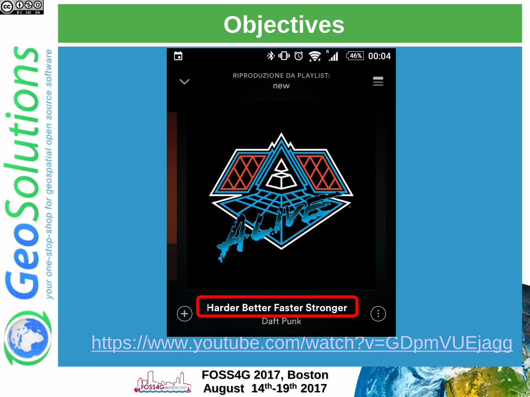
Possible structures
Single GeoTiffwith internal tiling
and overviews
(GeoTiff < 2GB,
BigTiff < 20-50GB)
Mosaic of GeoTiff, each one
with internal tiling and overviews
(< 500GB, not too many files)Pyramid
1
2
3
FOSS4G 2017, BostonAugust 14th-19th 2017

Choosing formats and layouts
For single granules (< 20Gb) GeoTiff is generally a
good fit
Use ImageMosaic when:
A single file gets too big (inefficient seeks, too much
metadata to read, etc..)
Multiple Dimensions (time, elevation, others..)
Avoid mosaics made of many very small files
Single granules can be large
Use Tiling + Overviews + Compression on granules
Use ImagePyramid when:
Tremendously large dataset
Too many files / too large files
Need to serve at all scales
Especially low resolution
FOSS4G 2017, BostonAugust 14th-19th 2017

Raster data preparation
Re-organize (merge files, create pyramid, reproject)
Compress (eventually)
Retile, add overviews
Get all the details in our training material:
FOSS4G 2017, BostonAugust 14th-19th 2017
http://geoserver.geo-solutions.it/edu/en/raster_data/index.html

Preparing vector inputs
FOSS4G 2017, BostonAugust 14th-19th 2017

Choosing a format
Slow formats, text
based, not indexed
WFS
GML
DXF
CSV
GeoJSON
Good formats, local
and indexable
Shapefile
GeoPackage
Spatial databases:
PostGIS, Oracle
Spatial, DB2, SQL
server, MySQL
NoSQL: SOLR,
MongoDB, …
FOSS4G 2017, BostonAugust 14th-19th 2017
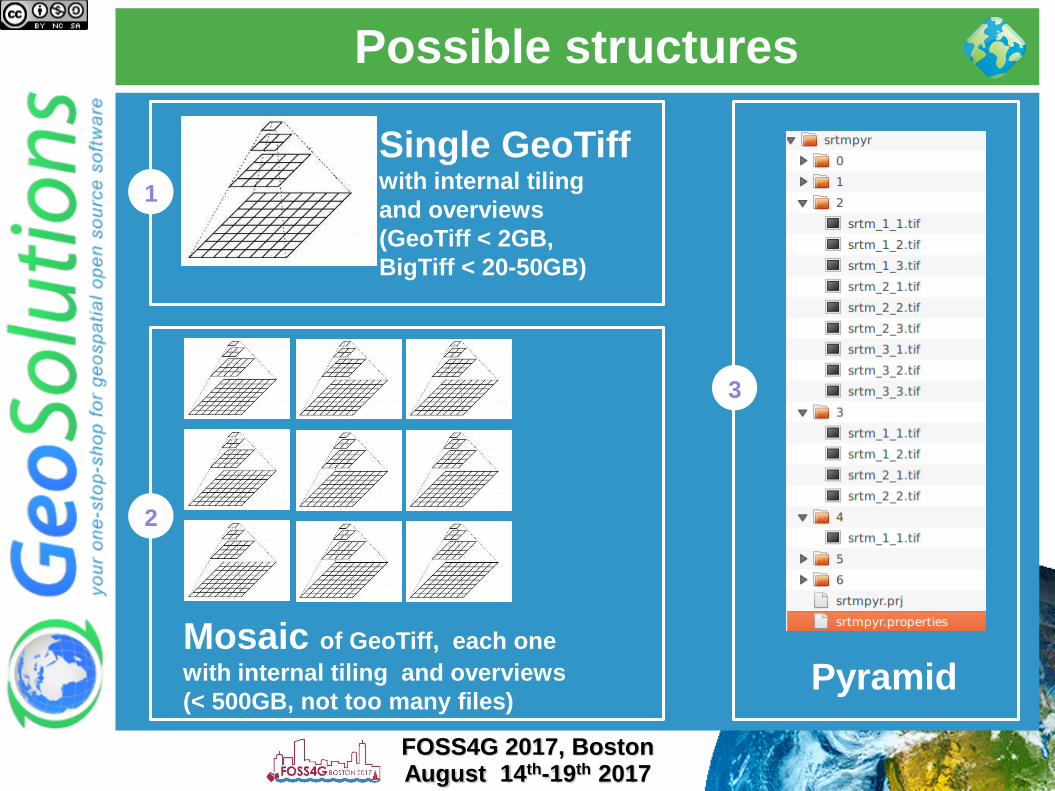
DBMS checklist
Choose PostGIS if you can, it has the best query
planner for spatial and plans every query based on
the query parameter (GIS makes for wildly different
optimal plans depending on the bbox you queried)
Rich support for complex native filters
Use connection pooling
Validate connections (with proper pooling)
Table Clustering
Spatial and Alphanumeric Indexing
Spatial and Alphanumeric Indexing
Spatial and Alphanumeric Indexing
…
Did we mention indexes?
FOSS4G 2017, BostonAugust 14th-19th 2017

Connection pooling tricks
Connection pool size should be proportional to the
number of concurrent requests you want to serve (obvious
no?)
Activate connection validation
Mind networking tools that might cut connections sitting
idle (yes, your server is not always busy), they might cut
the connection in “bad” ways (10 minutes timeout before
the pool realizes the TCP connection attempt gives up)
Read more
Advanced Database Connection Pooling
Configuration
DBMS Connections Params Explained
FOSS4G 2017, BostonAugust 14th-19th 2017
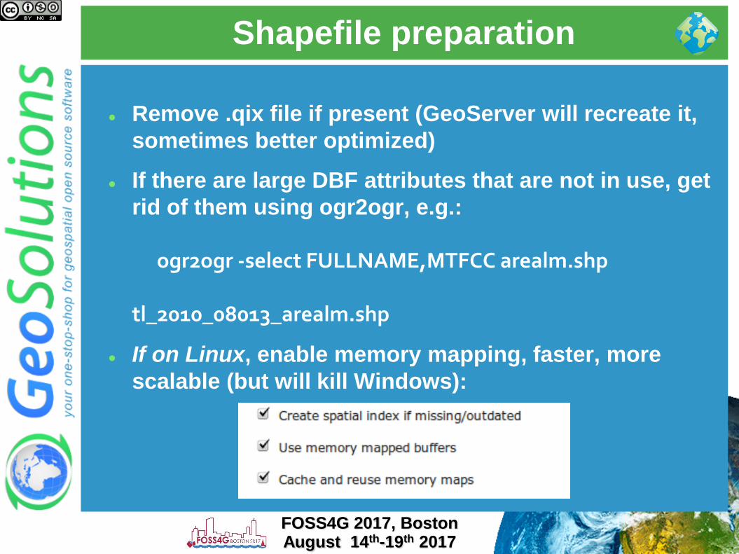
Shapefile preparation
Remove .qix file if present (GeoServer will recreate it,
sometimes better optimized)
If there are large DBF attributes that are not in use, get
rid of them using ogr2ogr, e.g.:
ogr2ogr -select FULLNAME,MTFCC arealm.shp
tl_2010_08013_arealm.shp
If on Linux, enable memory mapping, faster, more
scalable (but will kill Windows):
FOSS4G 2017, BostonAugust 14th-19th 2017

Shapefile filtering
Stuck with shapefiles and have scale dependent
rules like the following?
Show highways first
Show all streets when zoomed in
Use ogr2ogr to build two shapefiles, one with just
the highways, one with everything, and build two
layers, e.g.:
ogr2ogr -sql "SELECT * FROM
tl_2010_08013_roads WHERE MTFCC in
('S1100', 'S1200')" primaryRoads.shp
tl_2010_08013_roads.shp
Or hire us to develop non-spatial indexing for
shapefile!
FOSS4G 2017, BostonAugust 14th-19th 2017

Optimize styling
FOSS4G 2017, BostonAugust 14th-19th 2017

Use scale dependencies
Never show too much data
the map should be readable, not a graphic blob. Rule of thumb: 1000 features max in the display
Show details as you zoom in
Eagerly add MinScaleDenominator to your rules
Add more expensive rendering when there are less features
Key to get both a good looking and fast map
FOSS4G 2017, BostonAugust 14th-19th 2017

Labeling
Labeling conflict resolution is expensive, limit to the
most inner zooms
Careful with maxDisplacement, makes for various
label location attempts
GeoServer 2.9 onwards has per char space allocation,
much better looking labelling, but more expensive
too, disable if in dire need via sysvar
–Dorg.geotools.disableLetterLevelCache=true
FOSS4G 2017, BostonAugust 14th-19th 2017

FeatureTypeStyle
GeoServer uses SLD FeatureTypeStyle objects as Z
layers for painting
Each one allocates its own rendering surface (which
can use a lot of memory), use as few as possible
FOSS4G 2017, BostonAugust 14th-19th 2017

z-ordering
Use DBMS as the data source
Add indexes on the fields used for z-ordering
If at all possible, use cross-feature type and cross-layer
z-ordering on small amounts of data (we need to go
back and forth painting it)
FOSS4G 2017, BostonAugust 14th-19th 2017

Tiling and caching
FOSS4G 2017, BostonAugust 14th-19th 2017

Tile caching with GWC
Tile oriented maps, fixed zoom levels and fixed grid
Useful for stable layers, backgrounds
Protocols: WMTS, TMS, WMS-C, Google Maps/Earth, VE
Speedup compared to dynamic WMS: 10 to 100 times, assuming tiles are already cached (whole layer pre-seeded)
Suitable for:
Mostly static layer
No/few dynamic parameters (CQL filters, SLD params, SQL query params, time/elevation, format options)
FOSS4G 2017, BostonAugust 14th-19th 2017

Embedded GWC advantage
No double encoding when using meta-tiling, faster
seeding
FOSS4G 2017, BostonAugust 14th-19th 2017

Space considerations
Seeding Colorado, assuming 8 cores, one layer, 0.1 sec
756x756 metatile, 15KB for each tile
Do yours: http://tinyurl.com/3apkpss
Not enough disk space? Set a disk quota
Zoom
levelTile count Size (MB)
Time to seed
(hours)
Time to
seed (days)
13 58,377 1 0 0
14 232,870 4 0 0
15 929,475 14 0 0
16 3,713,893 57 1 0
17 14,855,572 227 6 0
18 59,396,070 906 23 1
19 237,584,280 3,625 92 4
20 950,273,037 14,500 367 15
FOSS4G 2017, BostonAugust 14th-19th 2017

Client side cache
Make client not request tiles, use their local cache
instead
HTTP headers, time to live, eTag
Does not work with browsers in private mode
<expireClientsList>
<expirationRule minZoom="0" expiration="7200" />
<expirationRule minZoom="10" expiration="600" />
</expireClientsList>
FOSS4G 2017, BostonAugust 14th-19th 2017

Choose the right format
Use the right formats:
JPEG for background data (e.g. ortos)
PNG8 + precomputed palette for
background vector data (e.g. basemaps)
PNG8 full for vector overlays with
transparency
image/vnd.jpeg-png for raster overlays
with transparency
The format impacts also the disk space
needed! (as well as the generation time)
Check this blog post
FOSS4G 2017, BostonAugust 14th-19th 2017

Vector tiles
Extension to support vector tiles
Still new, but:
PNG encoding is often 50% of the request
time when there is little data in the tile
Gone with Vector tiles
Vector tiles allow over-zooming, meaning
you can build less zoom levels (reducing
the total size by a factor of 4 or 16)
Vector tiles are more compact
However, not an OGC/ISO standard
FOSS4G 2017, BostonAugust 14th-19th 2017
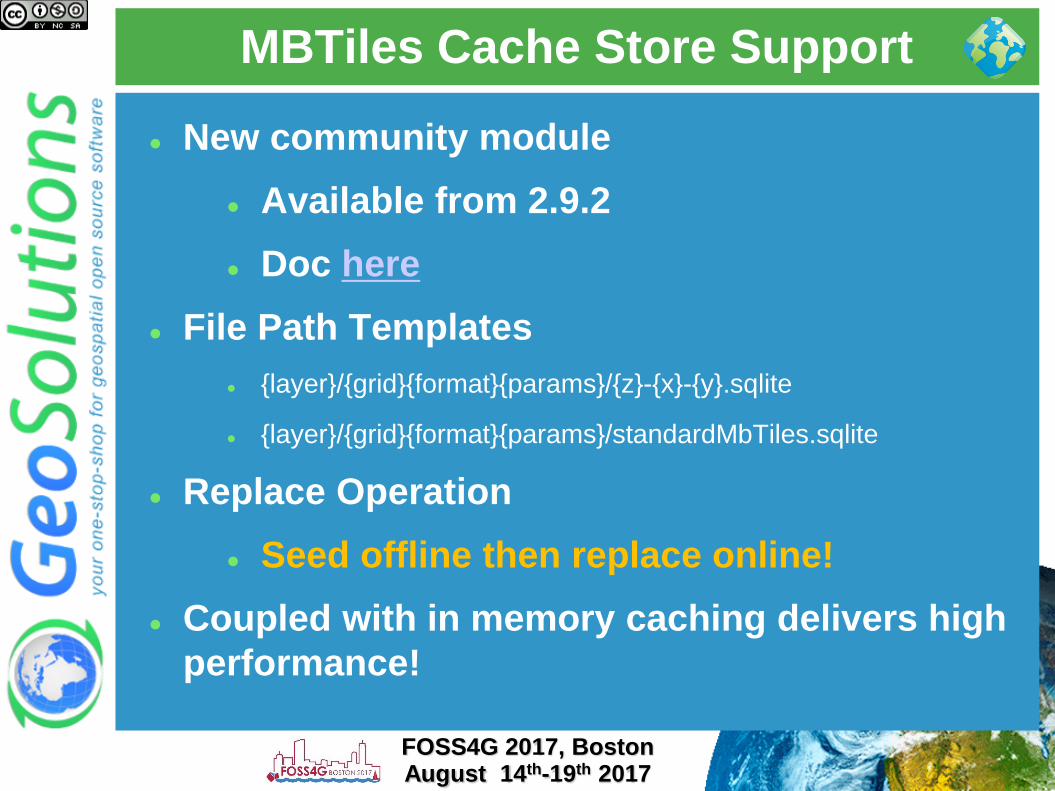
MBTiles Cache Store Support
New community module
Available from 2.9.2
Doc here
File Path Templates
{layer}/{grid}{format}{params}/{z}-{x}-{y}.sqlite
{layer}/{grid}{format}{params}/standardMbTiles.sqlite
Replace Operation
Seed offline then replace online!
Coupled with in memory caching delivers high
performance!
FOSS4G 2017, BostonAugust 14th-19th 2017
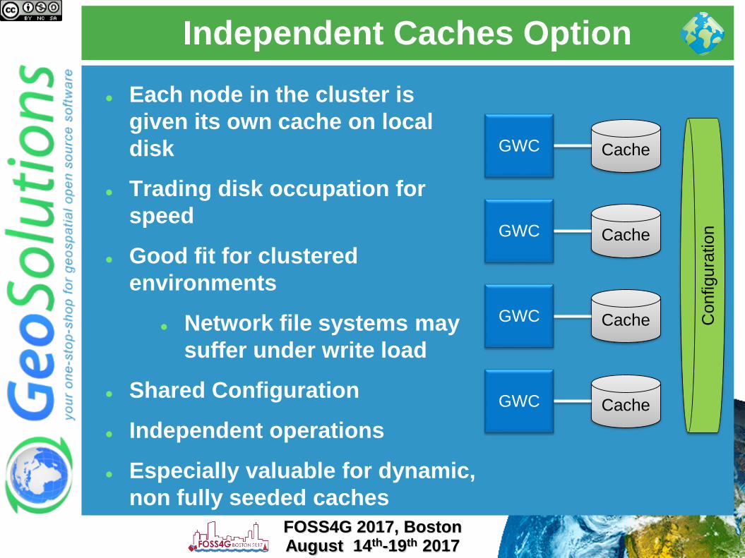
Independent Caches Option
Each node in the cluster is
given its own cache on local
disk
Trading disk occupation for
speed
Good fit for clustered
environments
Network file systems may
suffer under write load
Shared Configuration
Independent operations
Especially valuable for dynamic,
non fully seeded caches
FOSS4G 2017, BostonAugust 14th-19th 2017
GWC Cache
GWC Cache
GWC Cache
GWC Cache
Configura
tion

Resource control
FOSS4G 2017, BostonAugust 14th-19th 2017

What happens on your server
FOSS4G 2017, BostonAugust 14th-19th 2017

Set the Resource Limits
Limit the amount of resources dedicated to an
individual request
Improve fairness between requests, by preventing
individual requests from hijacking the server and/or
running for a very long time
EXTREMELY IMPORTANT in production environment
WHEN TO TWEAK THEM?
Frequent OOM Errors despite plenty of RAM
Requests that keep running for a long time (e.g.
CPU usage peaks even if no requests are being
sent)
DB Connection being killed by the DBMS while in
usage (ok, you might also need to talk to the DBA..)
FOSS4G 2017, BostonAugust 14th-19th 2017

Resource limits per service
WMS
WFS WCS
FOSS4G 2017, BostonAugust 14th-19th 2017

Control-flow
Control how many requests are executed in parallel,
queue others:
Increase throughput
Control memory usage
Enforce fairness
More info here
FOSS4G 2017, BostonAugust 14th-19th 2017
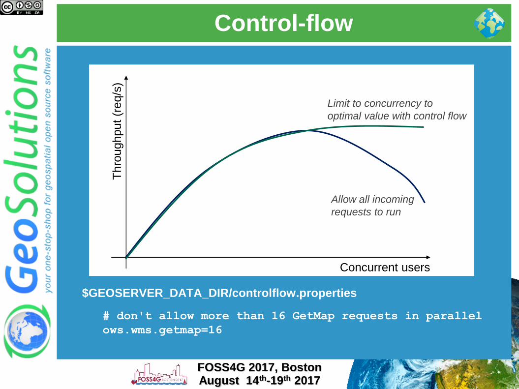
Control-flow
$GEOSERVER_DATA_DIR/controlflow.properties
# don't allow more than 16 GetMap requests in parallel
ows.wms.getmap=16
FOSS4G 2017, BostonAugust 14th-19th 2017
Thro
ughput
(req/s
)
Concurrent users
Allow all incoming
requests to run
Limit to concurrency to
optimal value with control flow

JVM and deploy configuration
FOSS4G 2017, BostonAugust 14th-19th 2017

Go back and optimize the rest first
There is no “GO FAST!” option in the Java
Virtual Machine
The options discussed here are not going to
help if you did not prepare the data and the
styles
They are finishing touches that can get
performance up once the major data
bottlenecks have been dealt with
Check “Running in production” instructions
here
FOSS4G 2017, BostonAugust 14th-19th 2017
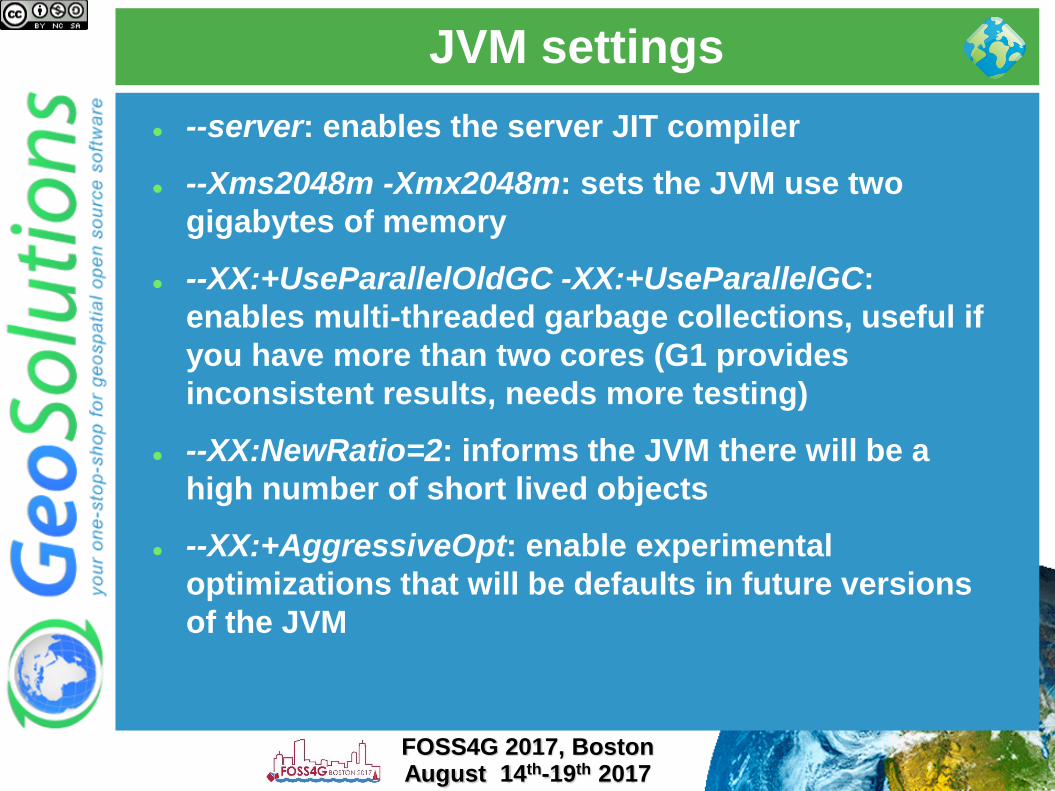
JVM settings
--server: enables the server JIT compiler
--Xms2048m -Xmx2048m: sets the JVM use two
gigabytes of memory
--XX:+UseParallelOldGC -XX:+UseParallelGC:
enables multi-threaded garbage collections, useful if
you have more than two cores (G1 provides
inconsistent results, needs more testing)
--XX:NewRatio=2: informs the JVM there will be a
high number of short lived objects
--XX:+AggressiveOpt: enable experimental
optimizations that will be defaults in future versions
of the JVM
FOSS4G 2017, BostonAugust 14th-19th 2017

Marlin renderer
The OpenJDK Java2D renderer scales up, but it’s not
super-fast when the load is small (1 request at a time)
The Oracle JDK Java2D renderer is fast for the single
request, but does not scale up
Marlin-renderer to the rescue:
https://github.com/bourgesl/marlin-renderer
It is already the
official renderer for
OpenJDK 9 (beta)
But for now
GeoServer won’t
run on JDK 9!
FOSS4G 2017, BostonAugust 14th-19th 2017

Upgrade!
Performance tends to go up version by version
Please do use a recent GeoServer version
FOSS4G 2010 vector benchmark with different
versions of GeoServer, throughput keeps on
improving
FOSS4G 2017, BostonAugust 14th-19th 2017

Raster subsystem configuration
Install the TurboJPEG extension
Enable JAI Mosaicking native
acceleration
Give JAI enough memory
Don’t raise JAI memory
Threshold too high
Rule of thumb: use 2 X #Core
Tile Threads (check next slide)
Play with tile Recycling against
your workflows (might help,
might not)
FOSS4G 2017, BostonAugust 14th-19th 2017

We are in prod, now what?
FOSS4G 2017, BostonAugust 14th-19th 2017
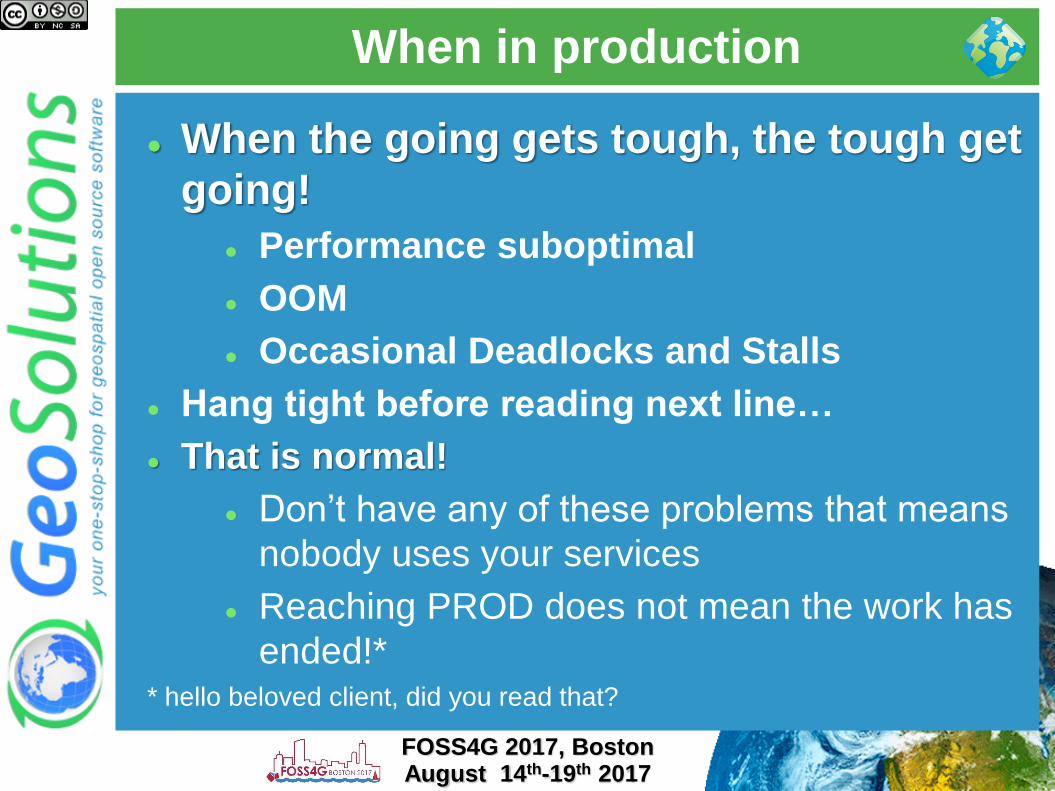
When in production
When the going gets tough, the tough get
going!
Performance suboptimal
OOM
Occasional Deadlocks and Stalls
Hang tight before reading next line…
That is normal!
Don’t have any of these problems that means
nobody uses your services
Reaching PROD does not mean the work has
ended!** hello beloved client, did you read that?
FOSS4G 2017, BostonAugust 14th-19th 2017

When in production
Ok, we are in the same boat
Thanks, but what can I do?
Here some key concepts
Logging
Monitoring
Metering
You want to be able to know what
happens before it actually happens*!
or better before someone call you on the phone screaming
and shouting!
FOSS4G 2017, BostonAugust 14th-19th 2017

When in production
Logging
When you are sick, a good doctor should
ask you how you feel, right?
We should do the same with GeoServer
Logs are hard to read
Logging levels are your friend
Look for known errors first
Logs of a network exposed service are
usually full of errors and exceptions
Unless nobody uses that service ☺FOSS4G 2017, BostonAugust 14th-19th 2017

When in production
Monitoring
When you are in PROD you have to
understand and monitor every bit
involved DBMS, Disks
CPU, Memory , Network
Other Software
Proactivity
Alerting low RAM, high cpu, low disk
space
Actions service dead/stuck then restart
FOSS4G 2017, BostonAugust 14th-19th 2017
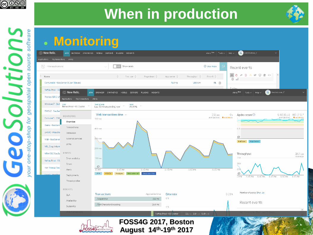
When in production
Monitoring
FOSS4G 2017, BostonAugust 14th-19th 2017

When in production
Monitoring
Troubleshooting GeoServer
FOSS4G 2017, BostonAugust 14th-19th 2017
When in production
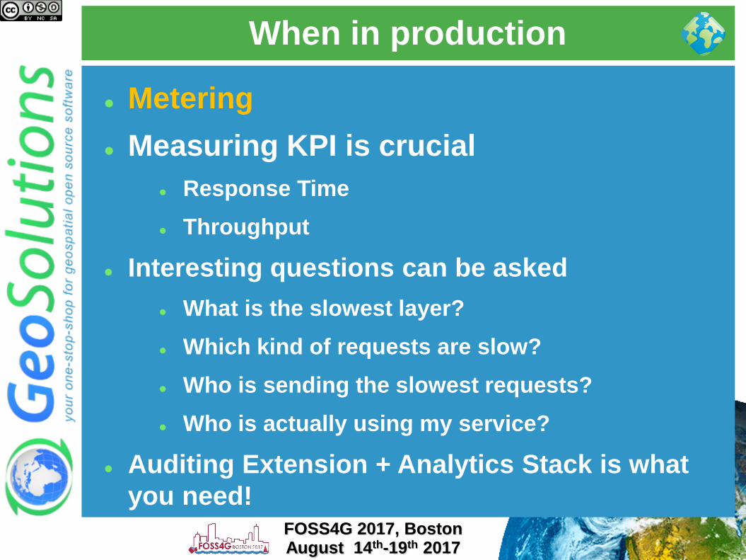
Metering
Measuring KPI is crucial
Response Time
Throughput
Interesting questions can be asked
What is the slowest layer?
Which kind of requests are slow?
Who is sending the slowest requests?
Who is actually using my service?
Auditing Extension + Analytics Stack is what
you need!FOSS4G 2017, BostonAugust 14th-19th 2017

When in production
Metering
FOSS4G 2017, BostonAugust 14th-19th 2017

When in production
Document the entire infrastructure
Monitor every bit
Use alerts and actions to be proactive
Keep calm and take snapshots before
taking actions
Is there any magic?
Well knowing your components
inside out helps a lot ☺
FOSS4G 2017, BostonAugust 14th-19th 2017