Embed Size (px)
Citation preview

Georgia Geography
Created by Blair Weikel
Adapted by Megan Rainwater

AKS:
• describe Georgia with regard to physical features and location (GPS SS8G1) (8SS_C2007-30)– 30a - locate Georgia in relation to region, nation, continent and
hemisphere– 30b - differentiate the five geographic regions of Georgia
including the Blue Ridge Mountains, Ridge and Valley, Appalachian Plateau, Piedmont and Coastal Plain
– 30c - locate and evaluate the importance of key physical features on the development of Georgia including Fall Line, Okefenokee Swamp, Appalachian Mountains, Chattahoochee and Savannah Rivers, and barrier islands
– 30d - evaluate the impact of climate on Georgia’s development

Lets get specific:• What hemisphere is
Georgia located in?– Northern Hemisphere
• What continent is Georgia located on?– North America
• What nation is Georgia located in?– United States of
America
• What region of the USA is Georgia located in?– Southeast
Now, lets use our maps to illustrate these locations.

My ExampleNorth
East
South
West
North American Continent
USA
Georgia
NORTHERN HEMISPHERE
SOUTHERN Hemisphere
Southeastern Part of the USA

Georgia’s Geographic Regions
Created by Blair Weikel
Adapted by Meg Rainwater

Before we begin…
• Using page 9 of your book label the following regions:– Coastal Plain– Piedmont– Blue Ridge Mountains– Ridge and Valley– Appalachian Plateau
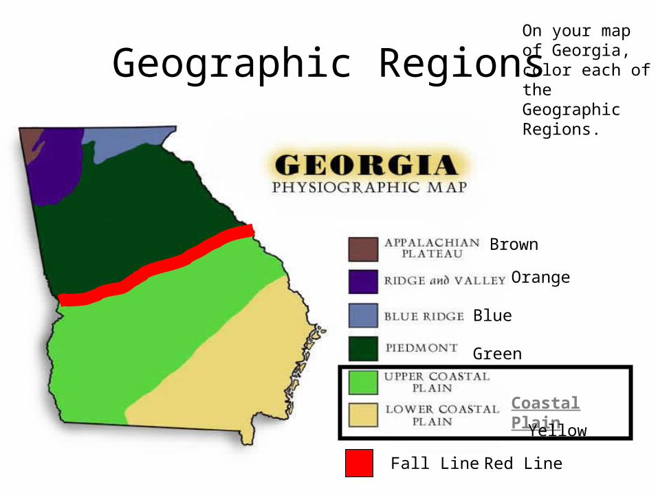
Geographic Regions
Coastal Plain
Fall Line
On your map of Georgia, color each of the Geographic Regions.
Brown
Orange
Blue
Green
Yellow
Red Line
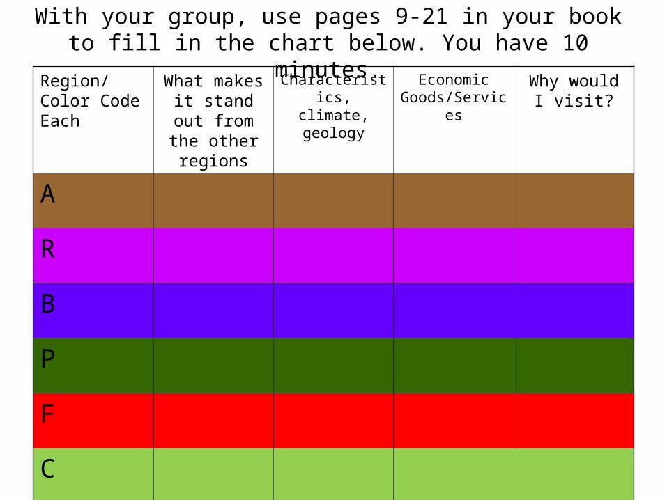
With your group, use pages 9-21 in your bookto fill in the chart below. You have 10 minutes.
Region/ Color Code Each
What makes it stand out from
the other regions
Characteristics, climate, geology
Economic Goods/Services
Why would I visit?
A
R
B
P
F
C

Appalachian Plateau
• Characteristics:– Smallest in state– Northwest corner of
the state– Lookout Mountain is
located in this region– Part of TAG Corner,
where Tennessee, Alabama, and Georgia meet
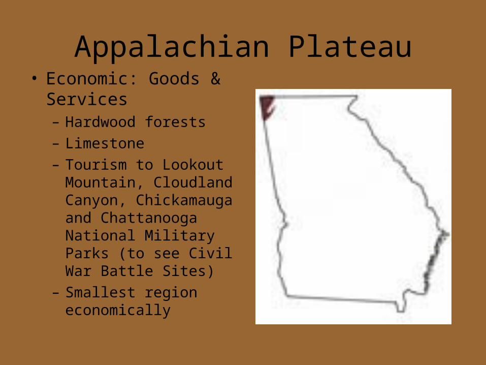
Appalachian Plateau• Economic: Goods &
Services– Hardwood forests– Limestone– Tourism to Lookout
Mountain, Cloudland Canyon, Chickamauga and Chattanooga National Military Parks (to see Civil War Battle Sites)
– Smallest region economically
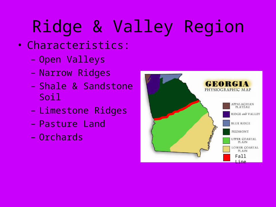
Ridge & Valley Region• Characteristics:
– Open Valleys– Narrow Ridges– Shale & Sandstone
Soil– Limestone Ridges– Pasture Land– Orchards
Fall Line

Ridge & Valley Region• Economic Goods and
Services– Mining– Farming– Apples are famous in
Ellijay– Carpet & Textiles are
located in Dalton, GA– Dalton GA is the
CARPET CAPITAL OF THE WORLD
Fall LineFall Line

Blue Ridge Region
• Characteristics:– Southernmost portion of the
Appalachian Mountains– Highest point in the State-
Brasstown Bald, 4784 feet above sea level
– First gold rush in the USA took place here in 1828
– Highest & largest group of mountains in the state located here
– Precipitation is prevalent & provides water for entire state
– Lots of erosion due to poor soil– Beginning of the Appalachian
Trail
Fall LineFall Line

Blue Ridge Region• Economic Goods and
Services– Tourism in the
Mountains– Helen GA &
Brasstown Bald are tourist attractions
– Hardwood forests– Vegetable farming– Apples Fall LineFall Line

Piedmont Region
• Characteristics:– Means “Foot of the Mountains”– Most populated region of the
state– Once home to plantations– Gently rolling hills– Heartland of the state know for
its red clay soil– ½ of the state’s population
lives here– Home to the state and regions
largest city: Atlanta– Home to the state’s capital:
Atlanta
Fall LineFall Line
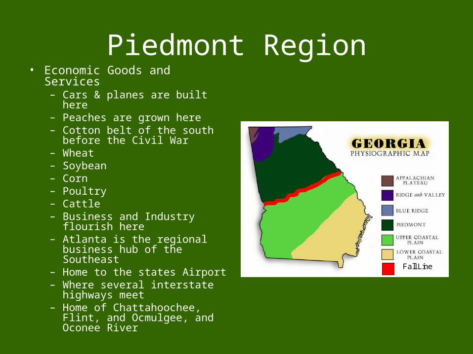
Piedmont Region• Economic Goods and Services
– Cars & planes are built here– Peaches are grown here– Cotton belt of the south before
the Civil War– Wheat– Soybean– Corn– Poultry– Cattle– Business and Industry flourish
here– Atlanta is the regional
business hub of the Southeast– Home to the states Airport– Where several interstate
highways meet– Home of Chattahoochee, Flint,
and Ocmulgee, and Oconee River
Fall LineFall Line

Fall Line• Characteristics:
– Geographic boarder where rivers produce waterfalls
– This is the ancient coastline that GA use to have when the ocean levels were higher
– Divides GA’s water sources:
• North of the Fall line, people rely on surface water or man-made reservoirs
• South of the Fall Line, aquifers allow people to use wells
Fall LineFall Line

Fall Line• Economic Goods and
Services– Early settlers were
deterred in their exploration due to all of the waterfalls
– Later settlers and current businesses use the waterfalls to provide power to their businesses
– Fertile soil and easy power make a great place to settle
– Cities like Augusta, Milledgeville, Macon & Columbus were formed because cargo was transferred form boats to trains and wagons
Fall LineFall Line

Coastal Plain• Characteristics:
– Forms Georgia’s boarder with Florida
– Forms the Atlantic Ocean Boarder
– 3/5 of the state– Largest region– Dougherty Plain= fertile
region where peanuts, corn, and pecan trees thrive
– Home to Savannah & Brunswick
– Home to barrier islands– Cumberland Island– Continental Shelf: part of
the continent that extends into the Atlantic Ocean
Fall LineFall Line

Coastal Plain• Economic Goods and
Services– Farming Hub of the state– Onion farming (Vidalia
Onions)– Fishing– Peanut Farming– Cotton Farming– Vegetable Farming– Tree Farming– Center for Navel stores– Savannah & Brunswick
Shipyards were liberty ships were built during WWII– Now, major ports in the state
– Tourism hub of state because of coastal towns
Fall LineFall Line

Georgia’s Physical Features
Created by Blair Weikel
Adapted By Meg Rainwater

Georgia’s Physical Features
• You will receive a map of Georgia to label several physical features on the back of the map, you will draw a chart to fill in about the features.
Fall LineFall Line
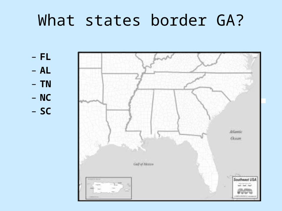
What states border GA?
– FL– AL– TN– NC– SC

Okefenokee Swamp• Means:
– Land of the Trembling Earth• Where:
– Southeastern part of Georgia– Outer coastal plain
• What: – Second largest freshwater
swamp in the USA• Covers ½ million acres
– National Wildlife Refuge is home to more than 1000 types of plants & animals
• Cypress trees dominate the landscape
• Black bears, snakes, alligators, armadillos, frogs, deer, water birds
• Home to the Seminole Indians

Appalachian Mountains • Stretch from GA to Maine
– Southeastern end of the Appalachian Mountain chain lies within Georgia’s Blue Ridge Region
– Brasstown Bald is the highest point in Georgia
– One hundred million years of erosion has worn away the Blue Ridge Mountains, they were once 75% taller than they are today
• Mining put this region on the map– GOLD was discovered in Dahlonega in
1828!
• Home to the Cherokee Indians

Chattahoochee River
• 436 mile waterway– Creates the border between
GA and AL– Supplies water for Atlanta– Transportation artery has
carried cotton, delivered power to textile mills, moved freight, furnished hydroelectric power, and provided drinking water for the state
• Cherokee for “river of the painted rock”
• Manmade lakes dot it:– Lake Lanier– West Pointe Lake– Walter E. George Reservoir

Savannah River• 314 mile waterway
– Forms the boarder between SC and GA
– The only river in GA that flows from outside the states boarders
• Means, “blue water”• Three manmade lakes are
along this river: – J. Strom Thurmond – Lake Lake Russell– Lake Hartwell
• Savannah & Brunswick Ports are located along the river
• Hernando de Soto was the first European to “see” this river
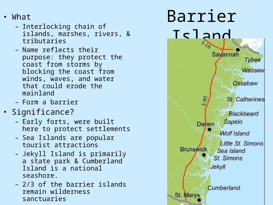
Barrier Island• What
– Interlocking chain of islands, marshes, rivers, & tributaries
– Name reflects their purpose: they protect the coast from storms by blocking the coast from winds, waves, and water that could erode the mainland
– Form a barrier
• Significance?– Early forts, were built here to
protect settlements– Sea Islands are popular tourist
attractions– Jekyll Island is primarily a state
park & Cumberland Island is a national seashore.
– 2/3 of the barrier islands remain wilderness sanctuaries

Atlantic Ocean• GA has 100 miles of
coastline along the Atlantic
• Major economic resource for the state:– Tourism, ports, fishing,
wildlife refuges, businesses
• Provides access to intracoastal waterway– 1000 mile inland
waterway that links New York to Miami, FL

Mini Quiz 1.The Chattahoochee River forms a border between Georgia and this state.
2.This feature flows along Georgia’s Eastern border.
3.This state borders GA to the South.
4.Gold was found in this area in the early 1800s. Today, tourists love to come here.
5.The Savannah River forms a border between GA and this state.
6.This state borders GA to the Northwest.
7.Forts were built here to defend early settlements of Georgia.
8.This area is a National Wildlife Refuge with more than 1,000 plants and animals.
9.This state borders GA to the Northeast.
10.This physical feature has tides.
11.This major river provides drinking water for Georgians and forms part of the state’s western border.
a) Savannah River
b) Okefenokee Swampc) Appalachian
Mountainsd) Atlantic Oceane) Chattahoochee Riverf) Barrier Islandg) Floridah) Alabamai) Tennesseej) North Carolinak) South Carolina

Climate! 30d.Evaluate the impact of climate on Georgia’s development
Created by Blair Weikel
Adapted by Meg Rainwater

Basic Definitions
• Climate - The day-to-day conditions and changes over a period of time. A regions’ climate remains stable over time.
• Weather - Refers to the day-to-day conditions and changes in the atmosphere. Weather varies constantly!
• Precipitation - The amount of water falling to earth at a specific place within a specified period of time; "the storm brought several inches of precipitation“
• The lack of precipitation over a period of time that results in water shortages.

Georgia
• Mild Climate• Four distinct seasons• Hot Summers• Highest temperatures
in state occur in July• Moderately cold
winters• Coldest temperatures
in state occur in January
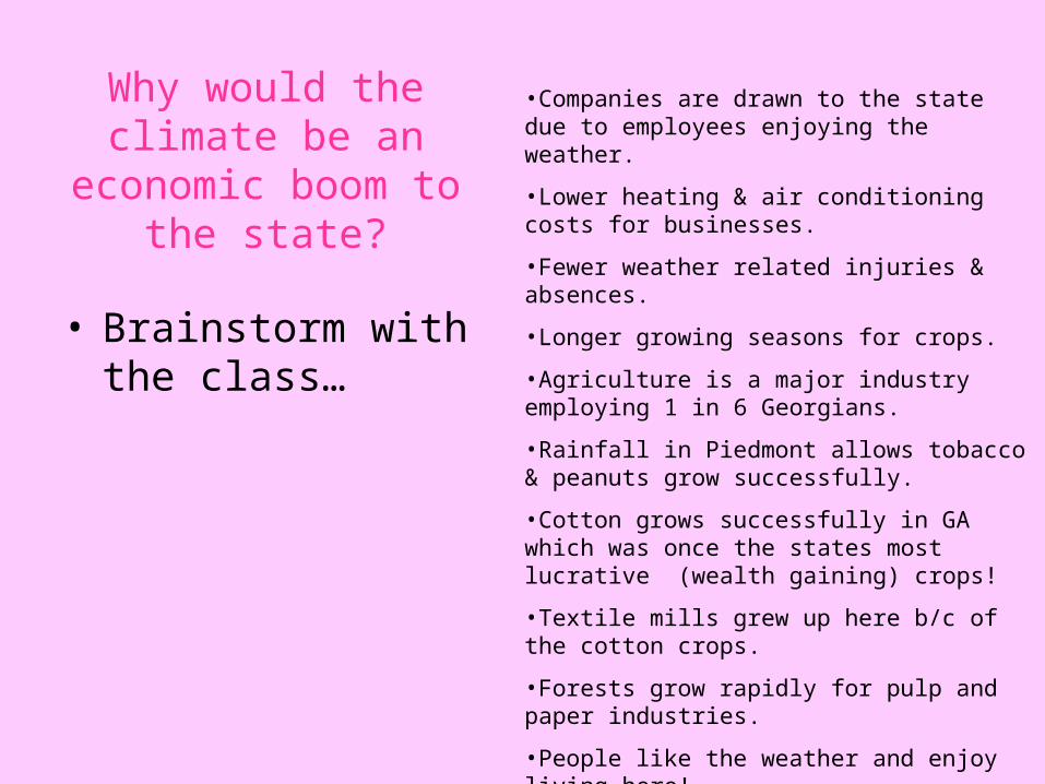
Why would the climate be an economic boom to the
state?
• Brainstorm with the class…
•Companies are drawn to the state due to employees enjoying the weather.
•Lower heating & air conditioning costs for businesses.
•Fewer weather related injuries & absences.
•Longer growing seasons for crops.
•Agriculture is a major industry employing 1 in 6 Georgians.
•Rainfall in Piedmont allows tobacco & peanuts grow successfully.
•Cotton grows successfully in GA which was once the states most lucrative (wealth gaining) crops!
•Textile mills grew up here b/c of the cotton crops.
•Forests grow rapidly for pulp and paper industries.
•People like the weather and enjoy living here!
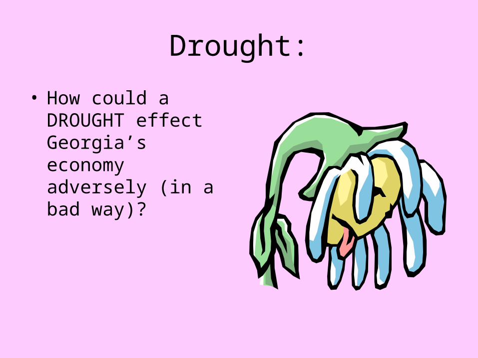
Drought:
• How could a DROUGHT effect Georgia’s economy adversely (in a bad way)?

More Definitions
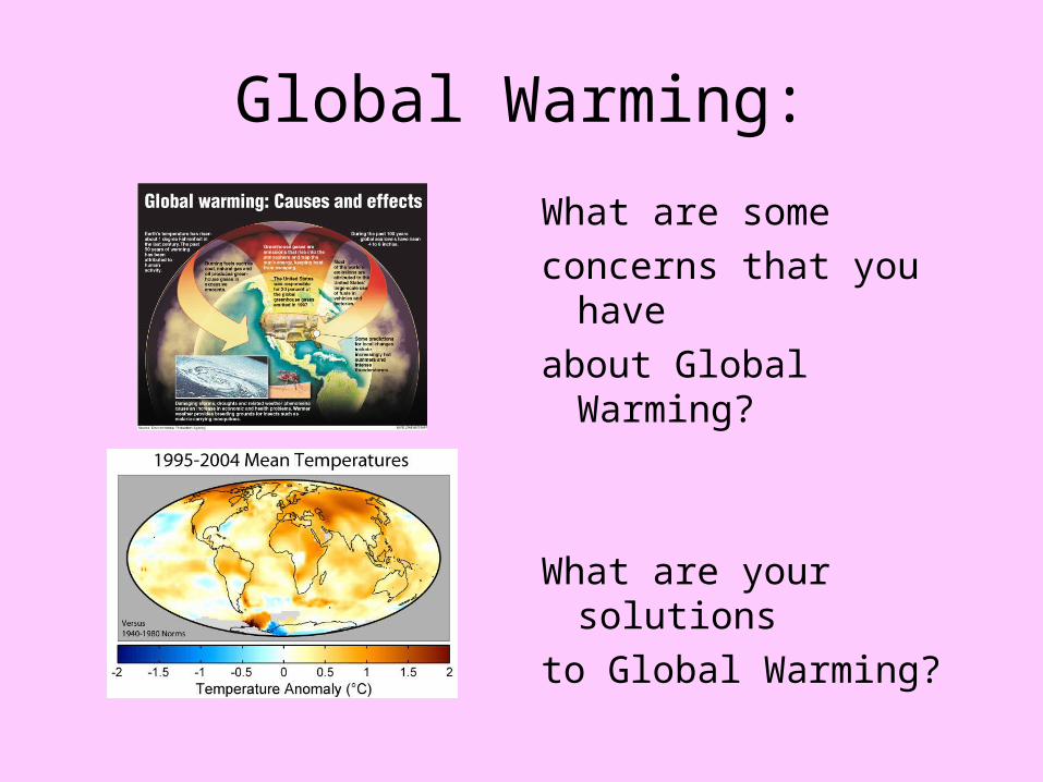
• Global Warming is the term that describes the raising of the average temperature on earth due to excess carbon dioxide in the atmosphere. Researchers are finding rising temperatures and precipitation amounts as results from global warming.
.
• Spawned when waters if 80 F or more transform the heat energy of tropical waters into strong winds and heavy waves
• Funnel shaped wind whirlwinds that are dangerous cyclonic
wind that move in a counterclockwise direction. As they touch the earth, they literally pull debris up into the air.
Global Warming:
What are some
concerns that you have
about Global Warming?
What are your solutions
to Global Warming?

Transportation!• explain how the interstate highway system,
Hartsfield - Jackson International Airport and Georgia’s deepwater ports help drive the state’s economy (GPS SS8G2) (8SS_C2007-31) • 31a - explain how the three transportation
systems interact to provide domestic and international goods to the people of Georgia
• 31b - examine how the three transportation systems provide jobs for Georgians

How do goods come into the state?
• Georgia is the center for transportation in the Southeast because…

What transportation systems, located in Georgia, lead to its economic success?
Seaports of Savannah, Brunswick and St. Marys
Hartsfield-Jackson International Airport
Interstate Highways
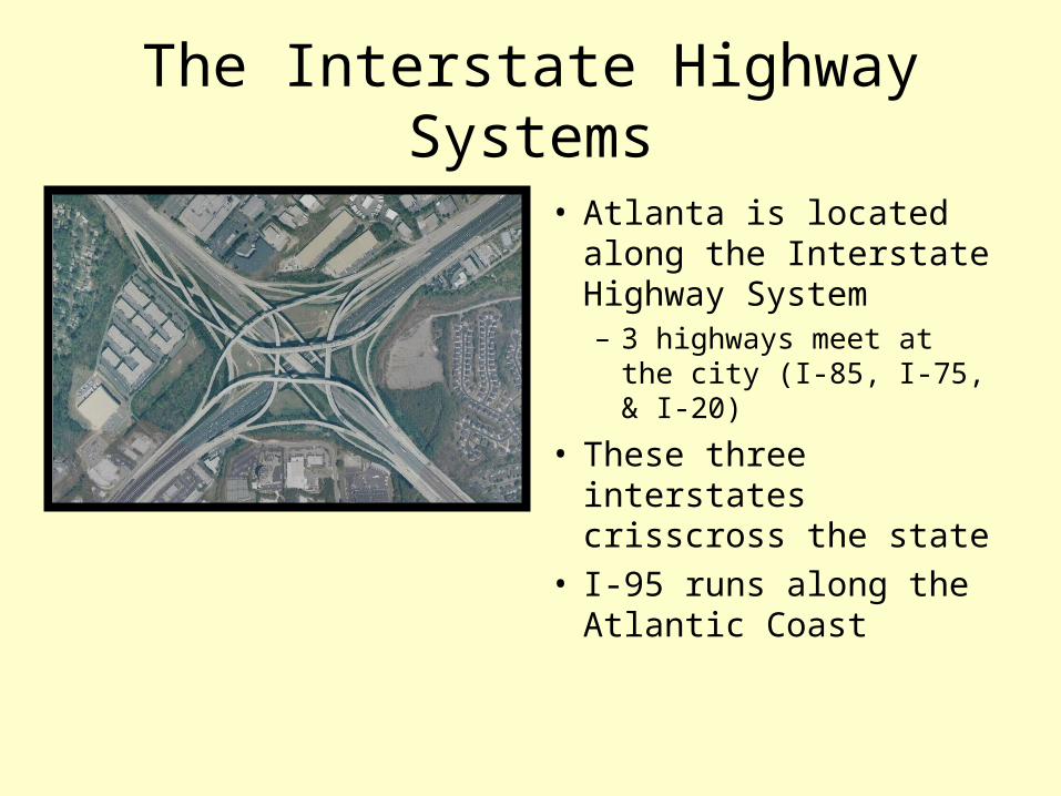
The Interstate Highway Systems
• Atlanta is located along the Interstate Highway System– 3 highways meet at the
city (I-85, I-75, & I-20)
• These three interstates crisscross the state
• I-95 runs along the Atlantic Coast

Hartsfield-Jackson International Airport
• The busiest airport in the world
• Handles close to 54,000 metric tons of cargo a month

Savannah, Brunswick & St. Mary’s Shipyard!
• Deepwater ports handle enormous loads of cargo– Cars– Containers
• Fruits• Vegetables• Computers• Appliances• Etc

What are the benefits of Georgia’s Transportation System?
•Provide state producers & service providers with excellent ways to distribute their products to national and international markets.
•Think GA Peaches in China
•Trucks carry shipments & containers to seaports & airports
•Ships carry parts to manufacturers in other countries
•Airplanes carry people and products all over the globe.
•GA’s investment in transportation systems is a huge factor in the states economic success!
•More jobs are available for GA residents!
Jobs…
• How do the transportation systems in GA increase the number of jobs in the state?

Jobs Grow:
• People are needed to:– Drive, load, unload,
and service trucks, planes & ships
• 16,000 jobs are supported for every $1 Billion of goods exported