Embed Size (px)
Citation preview
Tectonophysics xxx (2013) xxx–xxx
TECTO-125740; No of Pages 20
Contents lists available at SciVerse ScienceDirect
Tectonophysics
j ourna l homepage: www.e lsev ie r .com/ locate / tecto
Geophysical anomalies and quartz microstructures, Eastern Warburton Basin,North-east South Australia: Tectonic or impact shock metamorphic origin?
Andrew Y. Glikson a,⁎, I. Tonguç Uysal b, John D. Fitz Gerald c, Erdinc Saygin c
a Planetary Science Institute, Australian National University and Queensland Geothermal Energy Centre of Excellence, University of Queensland, Australiab Queensland Geothermal Energy Centre of Excellence - University of Queensland, Australiac Research School of Earth Science, Australian National University, Australia
⁎ Corresponding author. Tel./fax: +61 2 6296 3853.E-mail address: [email protected] (A.Y. G
0040-1951/$ – see front matter © 2013 Elsevier B.V. Allhttp://dx.doi.org/10.1016/j.tecto.2012.12.036
Please cite this article as: Glikson, A.Y., et alAustralia: Tectonic or impact shock metam
a b s t r a c t
a r t i c l e i n f oArticle history:Received 9 July 2012Received in revised form 23 November 2012Accepted 25 December 2012Available online xxxx
Keywords:Warburton BasinCooper BasinQuartz planar microstructuresMagnetic anomalyTomography anomalyGeothermal
The EasternWarburton Basin, Northeast SouthAustralia, featuresmajor geophysical anomalies, including amag-netic high of near-200 nT centred on a ~25 km-widemagnetic low (b100 nT), interpreted in termsof amagmat-ic body below 6 km depth. A distinct seismic tomographic low velocity anomaly may reflect its thick (9.5 km)sedimentary section, high temperatures and possible deep fracturing. Scanning electronmicroscope (SEM) anal-yses of granites resolves microbreccia veins consisting of micron-scale particles injected into resorbed quartzgrains. Planar and sub-planar elements in quartz grains (Qz/PE) occur in granites, volcanics and sediments ofthe >30,000 km-large Eastern Warburton Basin. The Qz/PE include multiple intersecting planar to curvedsub-planar elements with relic lamellae less than 2 μm wide with spacing of 4–5 μm. Qz/PE are commonlyre-deformed, displaying bent and wavy patterns accompanied with fluid inclusions. U-stage measurements ofa total of 243 planar sets in 157 quartz grains indicate dominance of ∏{10–12}, ω{10–13} and subsidiary§{11–22}, {22–41}, m{10–11} and x{51–61} planes. Transmission Electron Microscopy (TEM) analysis displaysrelic narrow≤1 μm-wide lamellae and relic non-sub grain boundaries where crystal segments maintain opticalcontinuity. Extensive sericite alteration of feldspar suggests hydrothermal alteration to a depth of ~500 m belowthe unconformity which overlies the Qz/PE-bearing Warburton Basin terrain. The data are discussed in terms of(A) Tectonic–metamorphic deformation and (B) impact shock metamorphism producing planar deformationfeatures (Qz/PDF). Deformed Qz/PE are compared to re-deformed Qz/PDFs in the Sudbury, Vredefort,Manicouagan and Charlevoix impact structures. A 4–5 km uplift of the Big Lake Granite Suite during~298–295 Ma is consistent with missing of upper Ordovician to Devonian strata and possible impact rebound.The occurrence of circular seismic tomography anomalies below the east Warburton Basin, the PoolowanaBasin and the Woodleigh impact structure signifies a potential diagnostic nature of circular tomographicanomalies.
© 2013 Elsevier B.V. All rights reserved.
1. Introduction
Geophysical and drilling exploration of the Australian continentand off shore continental shelves have led to the discovery of largecircular structures some of which contain evidence of shock metamor-phism, including Woodleigh (120 km-diameter; ~359±4 Ma; Gliksonet al., 2005a,b; Iasky et al., 2001; Mory et al., 2000; Reimold et al.,2003; Uysal et al., 2001, 2002) and Talundilly (90 km-diameter;~112–115 Ma; Gorter and Glikson, 2012; Longley, 1989). Possible im-pact structures include Gnargoo (D=75 km; Iasky and Glikson, 2005)and Mount Ashmore (>50 km-diameter; end-Eocene; Glikson et al.,2010). Here we consider the significance of magnetic, gravity and seis-mic tomography anomalies associated with the Eastern WarburtonBasin, buried under the south-western Cooper Basin (Fig. 1), includingthe identification of planar and sub-planar microstructures in quartz
likson).
rights reserved.
., Geophysical anomalies andorphic origin? Tectonophysic
grains in late Carboniferous granites and early Palaeozoic sedimentsand volcanic rocks in this terrain.
The Warburton Basin extends over an area ~400,000 km2 innorth-eastern South Australia (Fig. 1). It consists of a >4.5 km thickearly Cambrian to early mid-Ordovician sequence, comprising abasal suite of felsic volcanic rocks overlain by late Cambrian carbon-ates and Ordovician pelagic to shelf clastic sediments (Gatehouse etal., 1995; Gravestock and Gatehouse, 1995; Radke, 2009; Roberts etal., 1990; Sun, 1997, 1998; Sun et al., 1994). Devonian sediments aremostly missing except in the north-west. The Eastern WarburtonBasin underwent deformation in the late Devonian (part of the AliceSprings Orogeny) as well as deformation associated with intrusion ofmid to late Carboniferous granitoids (Big Lake Granite Suite; 323±5 Ma to 298±4 Ma; Gatehouse et al., 1995). Emplacement of thegranites was followed by rapid uplift by 4–5 km at ~298–295 Ma(Gravestock and Jensen-Schmidt, 1998), leading to deep erosion asso-ciated with end-Carboniferous glaciation, which accounts for a majorunconformity and a lacuna of missing mid-Ordovician to upper
quartz microstructures, Eastern Warburton Basin, North-east Souths (2013), http://dx.doi.org/10.1016/j.tecto.2012.12.036

Fig. 1. Known extent of the Warburton Basin based on the ‘C’ seismic horizon (Cretaceous marker). The Birdsville Track Ridge divides the eastern Warburton Basin, which underliesthe Cooper Basin, from the Western Warburton Basin, also termed Poolowana Basin.From Fig. 9 of Radke (2009).
2 A.Y. Glikson et al. / Tectonophysics xxx (2013) xxx–xxx
Carboniferous strata (Veevers, 2009). The Cooper Basin above theEastern Warburton Basin comprises a ~2 km-thick sequence of lateCarboniferous and Permian glacial deposits (Merimelia and Tirrawarraformations) deformed along NE–SW tectonic ridges (Gidgealpa–Merrimelia–Yanapurra, Innamincka, Nappacoongee, Murteree, Dunoonridges) separated by paleo-depressions (Patchawarra, Nappamerri,Allunga and Tenappera troughs) (Fig. 2). The Cooper Basin, whichhosts major geothermal, oil and gas deposits (Chopra, 2003; PIRSA,2010a–d;Wyborn et al., 2004), is overlain by a 3 km-thickMesozoic se-quence of the Eromanga Basin.
Planar and sub-planar elements in quartz (Qz/PE)1 grains ingranites, sediments and volcanic rocks, identified in drill core samples(Appendix I), extend over an area ~220×195 km-large (betweenWalkillie-1 in the north, Cutapirrie-1 in the south, Kalladeina-1, andJennet-1 in the west and Tickalara-1 in Queensland in the east)(Figs. 1, 2; Appendix I). The nature and significance of thesemicrostruc-tures will be considered in relation to magnetic, gravity, seismic and
1 Terms used in this paper are defined as follows: Qz/PE — planar elements in quartzof no genetic connotation; Qz/MDL — metamorphic deformation lamella in quartz ofknown tectonic origin; Qz/PDF — Planar deformation features of shock metamorphicorigin.
Please cite this article as: Glikson, A.Y., et al., Geophysical anomalies andAustralia: Tectonic or impact shock metamorphic origin? Tectonophysic
tomographic data from the Eastern Warburton Basin and underlyingcrust.
2. Structure of the Cooper and Eastern Warburton basins
2.1. Paleo-structure of the Warburton Basin
Isopach maps outline the south-western part of the Cooper Basinas an elongated NE–SW depression split into at least three troughsby arcuate tectonic ridges which separate end-Carboniferous tomid-Triassic depositories of the Cooper Basin (Figs. 1 and 2). These line-aments include from north to south the Birdsville Track Ridge,Gidgealpa–Merimelia–Innamincka (GMI) Ridge, Big Lake fault, WarraRidge and the Dunoon–Murteree and Nappacoongee Ridges which sepa-rate the Cooper Basin into the Patchawarra, Nappamerri, Tenappera andAllunga troughs (Fig. 2) (Boucher, 2001, 2002; Gravestock andJensen-Schmidt, 1998; Meixner et al., 1999, 2000; Sun, 1997). Thepre-end Carboniferous unconformity, defined as the Z seismic horizon,is near-4000 m deep and is underlain by early Palaeozoic WarburtonBasin sediments intruded by Big Lake Granite Suite (Gravestock andJensen-Schmidt, 1998; Meixner et al., 1999, 2000; PIRSA, 2010a–d;Radke, 2009; Sun, 1997). The isopach maps (PIRSA, 2010a–d) suggest
quartz microstructures, Eastern Warburton Basin, North-east Souths (2013), http://dx.doi.org/10.1016/j.tecto.2012.12.036

Fig. 2. Top ‘basement’ (Z horizon) depth structure map and structural elements, including key ‘basement’well intersections sub-cropping beneath the Cooper and Eromanga Basins.The Z horizon (base of the Cooper Basin) was mapped from seismic data with well log control. The ‘basement’ includes Cambro-Ordovician Warburton Basin sediments andvolcanics, Carboniferous intrusives and Proterozoic metasediments. The airborne survey area covering the Strzelecki and Innamincka 1:250 000-scale map sheets is shown.From Meixner et al. (2000).
3A.Y. Glikson et al. / Tectonophysics xxx (2013) xxx–xxx
that the evolution of the Cooper Basin was controlled by movementsalong these early lineaments, including northwest-directed thrustingalong the GMI ridge (Fig. 2). The origin of the northeast-trending ridgesmay be attributed to northwest – southeast compression associatedwith pre-late Carboniferous tectonic events (Radke, 2009) or, alterna-tively, to paleo-topographic basement features (Boucher, 1996).
2.2. Magnetic and Bouguer gravity anomalies
The crust underlying the Patchawarra trough, the northern sectorof the southwest Cooper Basin, is marked by a positive magnetic
Please cite this article as: Glikson, A.Y., et al., Geophysical anomalies andAustralia: Tectonic or impact shock metamorphic origin? Tectonophysic
anomaly >15,000 km2-large reaching +200 nT, centred by the~25 km-wide Tirrawarra magnetic anomaly of up to +100 nT (Fig. 3).The anomaly has been modelled in terms of a deep seated (>6 km)mafic body (Meixner et al., 1999, 2000) (Fig. 4). Modelling of gravityanomalies below the Patchawarra trough, using background values of~2.8 g/cm3, leads to density estimates in the range of 2.8–2.99 g/cm3
(A. Meixner, pers. com., 2011). Positive gravity anomalies are stronglyoverprinted by Northeast–southwest tectonic ridges and depressions,the latter reflecting low-density granite cupolas of the Big Lake GraniteSuite (Fig. 4). Meixner et al. (2000) interpret the sub-Patchawarramag-netic high in the following terms: “This body may have resulted from
quartz microstructures, Eastern Warburton Basin, North-east Souths (2013), http://dx.doi.org/10.1016/j.tecto.2012.12.036

Fig. 3. (A) Airborne magnetic image of eastern Central Australia (Geoscience Australia). The black circle corresponds to the white circle in (B); (B) 1st vertical derivative image of theCooper Basin and surrounds (Geoscience Australia): dotted white circle outlines the minimum distribution of Qz/PE in Eastern Warburton Basin strata and intrusive granitoids fromthe present study of drill holes; dotted circle T — the Tirrawarra magnetic anomaly, as in image C; (C) low-pass filtered image of the total magnetic intensity reduced to the pole gridincluding ‘Basement’well intersections (Big Lake Granite Suite— red, Mooracoochie Volcanics— yellow, basalt— green, sediments— tan, Proterozoic— blue). The image contains mag-netic intensities ranging from−110 nT (black) to 260 nT (white).
4 A.Y. Glikson et al. / Tectonophysics xxx (2013) xxx–xxx
magma formed by decompression processes associated with crustal exten-sion related to basin formation. Another possibility is that the magma orig-inated from hot spot activity and there has been subsequent thermalsubsidence”.
The Patchawarra trough is bound to the southeast by thrust faultsassociated with the GMI Ridge, showing about 3.5 km northwardmovement (Meixner et al., 2000) (Fig. 5). To the northwest the troughis bound by doming of the Birdsville Track Ridge. The strong gravitylow of the deep Nappamerri trough to the south represents thelow-density of the Big Lake Granite Suite, regarded as high level cupolasof a deeper batholith (Fig. 4). The high-density magnetic body belowthe Patchawarra trough may be interpreted in terms of up-doming ofthe deep crust.
Possible western and north western margins of a circular structuremay be outlined by airborne magnetic maps by anomalies in the west(Fig. 3). The circle outlined in the figure contains the known mini-mum distribution of Qz/PEs in the Warburton Basin terrain. A paucityof drill holes west of the Birdsville Track Ridge precludes tests of pos-sible quartz microstructures in this area. The relations between theWarburton Basin and the Worominta terrain to the southeast are ob-scured by the 3 to 4 km-thickness of overlying sediments.
Please cite this article as: Glikson, A.Y., et al., Geophysical anomalies andAustralia: Tectonic or impact shock metamorphic origin? Tectonophysic
2.3. Seismic tomography
Seismic ambient noise tomography has recently become an impor-tant tool to image the seismic velocity structure of the Earth from shal-low to lower crust. A number of studies have been conducted atdifferent parts of the Earth (US, Shapiro et al., 2005; South Korea, Kangand Shin, 2006; Australia, Saygin and Kennett, 2010, 2012; Arroucauet al., 2010; Europe, Yang et al., 2007; Stehly et al., 2009). The methoduses the ambient seismic waves continuously recorded at seismicstations around the world. By cross-correlating the simultaneouslyrecorded seismic ambient noise at two different stations, Green'sfunction of the Earth can be extracted. This wavelet carries informa-tion from the medium along the connecting path of the two stations.By systematically conducting cross-correlations between the differentstations of a seismic network, it is possible to measure the traveltime variations between each station pair. These measurements arethen used in a tomographic inversion method to map variationsof the seismic velocities for the region that is covered by the seismicnetwork.
A recent study of the ambient seismic noise tomography of theAustralian continent (Saygin and Kennett, 2010, 2012) indicates close
quartz microstructures, Eastern Warburton Basin, North-east Souths (2013), http://dx.doi.org/10.1016/j.tecto.2012.12.036

Fig. 4. (a) Bouguer gravity image showing interpreted granitic bodies and Basement well intersections (Big Lake Suite Granite — red, Mooracoochie Volcanics — yellow, basalt —green, sediments — tan, Proterozoic — blue). The positions of modelled profiles (yellow) are shown. The image contains gravity values ranging from −40 mm/s2 (black) to −9 mm/s2 (white). The letters refer to features discussed in the text. (b) Computer modelling along profiles shown in (a). A background density of 2.8 g/cm3 and a backgroundsusceptibility of 0.0 SI were used.Figures 6 and 8 of Meixner et al., 2000.
Fig. 5. A composite NW–SE seismic section showing a regional correlation of seismic packages between the Birdsville Track Ridge (BT), Patchawarra Trough (PT) and the Gidgealpa–Merrimelia–Innamincka Ridge (GMI) (see Figs. 1, 2), displaying NW-oriented thrusting and doming beneath the Patchawarra Trough, NW Cooper Basin. Z — seismically definedbasal Cooper unconformity above the Warburton Basin; P — basal Permian horizon; C — basal Cretaceous horizon.Figure 4A of Sun, 1997.
5A.Y. Glikson et al. / Tectonophysics xxx (2013) xxx–xxx
Please cite this article as: Glikson, A.Y., et al., Geophysical anomalies and quartz microstructures, Eastern Warburton Basin, North-east SouthAustralia: Tectonic or impact shock metamorphic origin? Tectonophysics (2013), http://dx.doi.org/10.1016/j.tecto.2012.12.036
6 A.Y. Glikson et al. / Tectonophysics xxx (2013) xxx–xxx
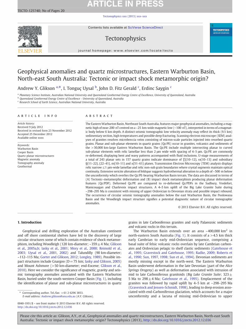
spatial correspondence between the features of the group wavespeedanomaly map and the characteristics of major geological provinces ofAustralia (Fig. 6a). In this study, Rayleigh type surface wave groupvelocity variation maps are created from the tomographic imaging ofthe ambient seismic noise cross-correlations.
Fig. 6. A. Results of group velocity tomography for the Australia continent using Rayleigh wavd) 12.5 s. From Saygin and Kennett, 2010. Low periods are interpreted in terms of sedimentapproximate distribution of Qz/PEs shown in Figs. 2 and 3. B. Rayleigh wave group velocitywith the Woodleigh impact structure, Carnarvon Basin, Western Australia.
Please cite this article as: Glikson, A.Y., et al., Geophysical anomalies andAustralia: Tectonic or impact shock metamorphic origin? Tectonophysic
Low wavespeeds show strong correlation with the thickness ofsedimentary cover along with high temperatures. The anomalieswhich are imaged with shorter period surface waves are mostlyassociated with thick sedimentary sequences. At the longer periods re-ducedwavespeeds aremost likely caused by the elevated temperatures.
e data extracted from ambient noise for different period ranges. a) 5 s. b) 6.6 s. c) 8.3 s.ary thicknesses and high periods in terms of temperature. The circle corresponds to thetomography at 4 s for Western Australia, displaying a low velocity anomaly coinciding
quartz microstructures, Eastern Warburton Basin, North-east Souths (2013), http://dx.doi.org/10.1016/j.tecto.2012.12.036

7A.Y. Glikson et al. / Tectonophysics xxx (2013) xxx–xxx
Thenorth-eastern part of SouthAustralia includes a sharp lowvelocityanomaly over the Eastern Warburton Basin (139°–141°E; 27°–29°S). Asecond strong anomaly corresponds to the West Warburton Basin(Poolowanna Trough, Simpson Desert Basin). The two anomalies areseparated from each other by the Birdsville Track Ridge (Figs. 1, 2, 6).Strong low velocity anomalies pertain to a short seismic period of up to8.3 s whereas somewhat weaker anomalies pertain to the 12.5 s period(Fig. 6a), which emphasizes the role of the combined ~9.5 km-thick sed-imentary pile of the Eromanga–Cooper–Warburton basins (Radke, 2009)(Fig. 7). However, relatively thin sedimentary thicknesses pertain to theWest Warburton (Poolowanna) Basin, where the strong tomographicanomalies (Fig. 6a) remain unexplained, hinting at yet unresolved factors.
The temperature image at 5 km depth (Somerville et al., 1994)(Fig. 8) indicates high-T anomalies extending over large regions innortheast South Australia, northwest New South Wales and westernQueensland. It follows that the marked tomographic low velocityanomalies of the east and west Warburton basins may involve factorsadditional to sedimentary thicknesses and temperatures, possibly in-cluding high degree of fracturing and deep crustal features, such asmagmatic bodies, consistent with Maixner's (1999, 2000) magneticand gravity model (Fig. 4).
3. Petrology and microstructural analysis
The significance of quartz microstructures observed in the EasternWarburton Basin and associated granites was investigated by polarisingmicroscopy, scanning electronmicroscopy and transmission electronmi-croscopy. Granitoid samples from Moomba-1, McLeod-1, Habanero-1and Big Lake-1 wells contain penetrative lamellar sets ≤1–2 μm-widespaced about≥4 μm apart within sectors of quartz grains. Quartz grainsin sediments and volcanic rocks from the Eastern Warburton Basin
Fig. 7. Phanerozoic and Proterozoic sediment thickness within the Central Basins region, deribetween and beyond delineated basins. These areas indicate either possible extension to theseFrom Radke, 2009.
Please cite this article as: Glikson, A.Y., et al., Geophysical anomalies andAustralia: Tectonic or impact shock metamorphic origin? Tectonophysic
disclose similar planar and sub-planar microstructures, commonlydisplaying wavy, bent and clouded features. Scanning electron micros-copy (SEM) and Energy Dispersive Spectrometry (EDS) analyses usinga Jeol-6400 SEM (analyst: A. Glikson; supervisors: F. Brink, H. Chen)was performed on 3 granitoid core samples (Moomba-1 2857.4m;McLeod-1 3745.9m; Big Lake-1 3057m), including point chemical anal-yses of element abundances at detection levels of >2000 ppm (Appen-dix III). Using a 15 KeV accelerating voltage, spot analyses were carriedwith a 1 micron-size beam, with a spectrum collection time of 80 s(120 s real time) at 8000 cps. Accuracy and precision are based on ref-erence standards by Astimex Scientific Limited MINM25-53 (SerialNumber 95–050) using standard olivine, diopside, almandine garnet,albite and barite.
The distribution of drill holes through the southern Cooper Basin isportrayed in Fig. 9. Moomba-1 2857.4m sample is an altered coarse-grained (~0.5 mm-large) granitoid with quartz displaying resorbedgrain boundaries injected by microbreccia composed of micron totens of micro-scale quartz, sericite and minor magnetite (Fig. 10A).McLeod-1 3745.9m sample is an altered coarse-grained granitoid con-taining K-feldspar, albite and sericite, injected by microbreccia veins.Hydrothermal alteration is manifested by partly corroded/resorbedquartz grains and partly corroded/resorbed magnetite grains (Fig. 10B).Big Lake-1 3057m sample is a K-feldspar–albite–quartz granitoidconsisting of resorbed quartz fragments injected by microbreccia.The corroded boundaries of quartz and magnetite grains and theabundance of sericite are consistent with hydrothermal alteration ofthe granitoids.
Measurements on a 4-axis Universal stage (Alexopoulos et al., 1988;Carter, 1965, 1968; Robertson et al., 1968; Stoffler and Langenhorst,1994; von Engelhardt and Bertsch, 1969) were performed on a totalof 243 planar and sub-planar elements within 157 quartz grains.The Qz/PE are only partly expressed in electron backscatter mode or
ved by modelling by FrOG Tech (2005). Relatively thick sedimentary successions extendPhanerozoic basins and/or undiscovered underlying Phanerozoic and Proterozoic basins.
quartz microstructures, Eastern Warburton Basin, North-east Souths (2013), http://dx.doi.org/10.1016/j.tecto.2012.12.036

Fig. 8. Estimated crustal temperature map at 5 km depth (Somerville et al., 1994) with matching low velocity anomalies (I–IV) of tomographic images from 8.3 s and 12.5 s.From Saygin and Kennett, 2010.
8 A.Y. Glikson et al. / Tectonophysics xxx (2013) xxx–xxx
secondary electron scanning (SE1) model since, where unaltered, theyconsist of material similar to identical to the host quartz, suggestingthat they do not constitute open cleavage. Planar and sub-planar ele-ments in quartz (Qz/PE) identified in the Moomba, McLeod, Big Lakeand Habanero drill holes include well-defined parallel micron-scalelamellae (≤2 μm) spaced at intervals commonly ≥4 μm (Fig. 11Ad,Da, c, Ea, b). Less well defined, undulating, wavy and bent planar fea-tureswhich displaywider inter-lamellar spacing of >5 μmare common(Fig. 11Ab, Cc, d). Many quartz grains contain multiple intersectingQz/PE (Fig. 11B). Planar and sub-planar features are commonlymarkedby fluid inclusions (“decorated PE”) (Fig. 11Bd, Cb, Da, Ec). Divergingplanar elements described as “feather” features (French and Koeberl,2010; Poelchau and Kenkmann, 2011) are observed (Fig. 11Ed).
Universal stage measurements using a 4-axis U-stage Leitz micro-scope (magnification ×120) focussed on granite samples, which com-monly contain large quartz grains with a higher proportion of relativelywell preserved planar and sub-planar Qz/PE. The analysis of Qz/PEs iscomplicated by the relatively small proportion of Qz/PE-bearing quartzgrains in most samples, the restriction of planar and sub-planar sets tosmall sectors within the grains and the common wavy and clouded na-ture of Qz/PE, requiring selection of least-bent elements for measure-ment. Measurements are complicated by: (1) recrystallization mosaicsand irregular extinction of the host quartz and thereby the definition ofthe C optic axis; (2) errors in the definition of the horizontal and verticalorientations of wavy Qz/PE, and (3) clouded nature of many quartzlamellae, obscuring the definition of planar and sub-planar verticality.
The relative paucity of PE-bearing quartz grains in any one thin sec-tion required preparation ofmultiple sections. For each Qz/PE themeanof 5measurements of the angle between the C optic axis and the pole toplanar elements (COAQZ^PPE) was recorded on the Wulf stereogram.Errors arising from the wavy and bent nature of many Qz/PE and errorsin readings of the C optic axis and vertical positioning of lamellae are es-timated to total ±5°.
Please cite this article as: Glikson, A.Y., et al., Geophysical anomalies andAustralia: Tectonic or impact shock metamorphic origin? Tectonophysic
The results are presented as frequency distribution plots correlatedwith Miller Indexed crystal lattice orientations (Fig. 12A,B,C). Measure-ments included 154Qz/PE sets in 78 quartz grains inMoomba-1, 38 setsin 28 grains in McLeod-1 and 51 sets in 51 grains in Warburton Basinsediments and volcanics, a statistical population consistent with studiesof theWoodleigh structure (51 planar sets/19 quartz grains, P. Haines inGlikson et al., 2005b), Chesapeake Bay (32 planar sets/24 grains; inFrench and Koeberl, 2010) and Yarrabubba (100 planar sets/44 quartzgrains; Macdonald et al., 2003). Planar elements in quartz grains maydisplay up to four intersecting Qz/PE sets (Fig. 12). 48% of Moomba-1and 16% of McLeod-1 quartz grains contain more than one Qz/PE set.
Measurements (Appendix II) are plotted in terms of (1) frequencypercent of measured angles (COAQZ^PPE) at 5° histogram intervals and(2) indexed Qz/PEwithin±3° for Qz/PE in granites and±4° for Qz/PEin sediments and volcanics (Fig. 12). Peak index measurements corre-spond to Miller indices {10–13}, {10–12}, {11–22}, {11–21}, {22–41},{10–11}, {10–10} and {51–61}. The plots demonstrate a prevalenceof {10–13} and {10–12}.
3.1. Transmission electron microscopy
Transmission electron microscopy was aimed at resolving thesubmicron-scale characterisation of planar and other microstructures,in particular the identification of their full crystallographic orienta-tion. Sample Moomba-1 2857.4m was chosen for preparation of apetrographic thin section mounted using crystalbond resin. This sec-tion was surveyed with polarised light to find the best examples ofplanar lamellar features in quartz grains. A 3 mm circular Cu gridwas glued to the section surface at one of these locations. This grid,with its attached piece of section, was carefully removed and thinnedin a conventional Ar-ion mill. After C-coating, the thinned specimenwas examined using 300 kV electrons for imaging, diffraction andEDX analysis in a Philips CM300 TEM (operating at 300 kV) equipped
quartz microstructures, Eastern Warburton Basin, North-east Souths (2013), http://dx.doi.org/10.1016/j.tecto.2012.12.036

Fig. 9. Thickness of an altered top basement zone in drill holes in the Cooper Basin.After Boucher, 2001, Figure A8.
9A.Y. Glikson et al. / Tectonophysics xxx (2013) xxx–xxx
with EDAX ultra-thin window X-ray detector and Gatan slow-scanCCD camera.
In petrographic thin section, the chosen grain appears as inFig. 13A–B. The angle between the trace of lamellae and the opticallyfast direction in the quartz crystal was noted to be ~10°. As displayedin Fig. 13B, healed fractures cross this crystal almost orthogonally tothe lamellar trace. Analysis of diffraction in TEM allows determinationof the full crystallographic orientation of the grain selected. The planeof the thin section is very close to normal to {10–1–2}. The averageorientation of the planar lamellae is approximately {62–87}. Whilelamellar orientation is near {10–11}, it is clearly not parallel to this
Please cite this article as: Glikson, A.Y., et al., Geophysical anomalies andAustralia: Tectonic or impact shock metamorphic origin? Tectonophysic
low-index plane, consistent with the non-zero optical extinctionangle measured in the light microscope for this section.
The lamellae in most places are composed of parallel walls acrosswhich the crystal orientation changes by a few degrees at most, in thissense they are subgrain boundaries. Adjacent walls are separated byb1 to 2 μmand they are unusual for subgrains in that thewallsmaintaina roughly constant separation (Fig. 13C). The sharpness of the lamellarboundaries varies considerably, in most places their walls are rough ata sub-micron scale (Fig. 13D), and in a few they are smooth and flat.Fig. 13D also shows that pores in the range 50–200 nm occur in thequartz crystal. Few of these are located at lamellar boundaries.
quartz microstructures, Eastern Warburton Basin, North-east Souths (2013), http://dx.doi.org/10.1016/j.tecto.2012.12.036

Fig. 10. A. Moomba-1 2857.4m: SEM image of hydrothermally altered microbreccia-injected granitoid. (a) backscatter image of microbreccia veins injected into quartz grains;(b) SE1 image of frame A; (c) secondary magnetite within microbreccia veins; (d) magnified view of microbreccia vein consisting of quartz, sericite and magnetite. B. McLeod-13745.9m SEM image of altered granitoid containing K-feldspar, albite and sericite, injected by microbreccia veins, including resorbed quartz grains and resorbed magnetite grains.(a) Microbreccia veins injected into radiating fractures in partly resorbed quartz grains; (b) resorbed magnetite grain within altered albite; (c) microbreccia containing K-feldsparand resorbed magnetite; (d) detail of microbreccia veins (MB) containing sericite and injected into quartz grains.
10 A.Y. Glikson et al. / Tectonophysics xxx (2013) xxx–xxx
There is usually a high but variable density of curved dislocationsin the crystal regions adjacent to the lamellar boundaries. In a few re-gions, the lamellae appear to be entirely defined by variation in dislo-cation density (Fig. 13E), without any presence of a recognisablesubgrain boundary or of a sharp crystal orientation change. In theparts of the thinned section where healed fracture planes were seenprior to specimen milling, the microstructure in TEM is very different.
Please cite this article as: Glikson, A.Y., et al., Geophysical anomalies andAustralia: Tectonic or impact shock metamorphic origin? Tectonophysic
Large angular pores are present, plus elongate subgrains which arequite different (Fig. 13F) in shape and orientation to those shownabove. Some pores were seen to contain a few tiny crystals (a fewnm thick) of other phases such as layer silicates. Regions surroundingpores and subgrains contain many dislocations.
The walls of the Qz/PEs were identified as having {62–87} crystal-lographic orientation. Such planes in quartz lie near 53° to the C axis,
quartz microstructures, Eastern Warburton Basin, North-east Souths (2013), http://dx.doi.org/10.1016/j.tecto.2012.12.036

Fig. 11. A. Planar Elements (Qz/PE) in quartz grains in sediments from drill cores in the Eastern Warburton Basin. Circles in (d) indicate planar intervals of b2 μm, suggestive a clas-sification in terms of Planar Deformation Features (Qz/PDF). Slight lamellar undulation (a–c) signifies either classification as Qz/MDL or post. B. Intersecting partly deformed PlanarDeformation Features (Qz/PDF) and planar features (Qz/PF) in quartz grains in sediments from drill cores in the Warburton Basin, including multiple cross sets. White lines markparallel to planar features. C. Metamorphic Deformation Lamellae (Qz/MDL) representing deformed Planar Deformation Features (Qz/PDF) and Planar Features (Qz/PF) in quartzgrains in sediments from drill cores in the Eastern Warburton Basin, displaying decorated planar cross sets (a & b) and undulating planar sets (c & d) (see text). D. Planar Defor-mation Features (Qz/PDF) in quartz in granitoids from the Moomba-1 and McLeod-1 drill holes. (a) NW–SE traces mostly spaced at b10 μm and superposed by a reticulate set ofplanar fractures (Qz/PF) (on the right hand side of the image). (b) 3 quartz grains containing penetrative Qz/PDF (grain A), partially expressed Qz/PDFs (grain B) and a wavy planarset (grain C). (c) Magnification of Qz/PDFs from image (a). The b2 μm intervals between planar elements allows distinction from tectonic Bohm lamellae. (d) Qz/PDFs in quartzgrain in granitoid sample from McLeod-1 drill hole, showing deflection along a younger fracture (top left). PPL — plane polarised. CN — cross nicols. E. Planar Deformation Features(Qz/PDF) in quartz in granitoids from the Moomba-1. (a) Qz/PDFs (north–south) superposed by a rectangular set of Planar Features (Qz/PF) and younger fractures. (b) Magnifiedimage of (a); (c) planar features, characterised by relatively crude inclusion-dotted planes; (d) feather-like planar features. PPL — plane polarised. CN — cross nicols. Note themultiple Qz/PDF and Qz/PF sets in (a), (b) and (c).
11A.Y. Glikson et al. / Tectonophysics xxx (2013) xxx–xxx
Please cite this article as: Glikson, A.Y., et al., Geophysical anomalies and quartz microstructures, Eastern Warburton Basin, North-east SouthAustralia: Tectonic or impact shock metamorphic origin? Tectonophysics (2013), http://dx.doi.org/10.1016/j.tecto.2012.12.036
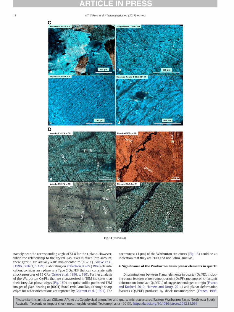
Fig. 11 (continued).
12 A.Y. Glikson et al. / Tectonophysics xxx (2013) xxx–xxx
namely near the corresponding angle of 51.8 for the r-plane. However,when the relationship to the crystal ba> axes is taken into account,these Qz/PEs are actually ~10° mis-oriented to {10–11}. Grieve et al.(1996, Table 1, p. 189), elaborating on Robertson et al.'s (1968) classifi-cation, consider an r plane as a Type C Qz/PDF that can correlate withshock pressures of 15 GPa (Grieve et al., 1996, p. 190). Further analysisof the Warburton Qz/PEs that are characterised in TEM indicates thattheir irregular planar edges (Fig. 13D) are quite unlike published TEMimages of glass-bearing or {0001} Brazil twin lamellae, although sharpedges for other orientations are reported by Goltrant et al. (1991). The
Please cite this article as: Glikson, A.Y., et al., Geophysical anomalies andAustralia: Tectonic or impact shock metamorphic origin? Tectonophysic
narrowness (1 μm) of the Warburton structures (Fig. 13) could be anindication that they are PDFs and not Bohm lamellae.
4. Significance of the Warburton Basin planar elements in quartz
Discriminations between Planar elements in quartz (Qz/PE), includ-ing planar features of non-genetic origin (Qz/PF), metamorphic–tectonicdeformation lamellae (Qz/MDL) of suggested endogenic origin (Frenchand Koeberl, 2010; Hamers and Drury, 2011) and planar deformationfeatures (Qz/PDF) produced by shock metamorphism (French, 1998;
quartz microstructures, Eastern Warburton Basin, North-east Souths (2013), http://dx.doi.org/10.1016/j.tecto.2012.12.036

Fig. 11 (continued).
13A.Y. Glikson et al. / Tectonophysics xxx (2013) xxx–xxx
French and Koeberl, 2010) are extensively discussed in the literature(Alexopoulos et al., 1988; Carter, 1965, 1968; Carter and Friedman,1965; Fairbairn, 1941; Ferrière and Osinski, 2009; French and Koeberl,2010; Grieve et al., 1996; Ingerson and Tuttle, 1945; Lyons et al., 1993;Vernooij and Langenhorst, 2005).
The following criteria have been proposed:
A. Qz/PDF lamellae are defined by diagnostic Miller indices, whichare correlated with specific shock levels (French, 1998). By con-trast Qz/MDL lamellae show a wide scatter of low COAQz^PPE an-gles ~20–30° as well as higher angles on frequency distributionplots (Lyons et al., 1993; French, 1998, figure 4.25).
B. Qz/PDF can form two or more sets in shock metamorphosed rocks(Grieve et al., 1996; Robertson et al., 1968; Stoffler and Langenhorst,1994). Qz/MDL consists mostly of only one set of lamellae withinany one quartz grain (French and Koeberl, 2010).
C. Qz/PDF lamellae are thinner at b1–2 μm-thick. Qz/MDL lamellaeconsist of segments usually >2–4 μm thick.
D. Qz/PDFs are originally perfectly planar. Qz/MDL may display undula-tion, bending and wavy patterns.
E. In TEMQz/PDFs display no optical misorientation between borderingcrystal segments. By contrast Qz/MDL form distinct boundaries be-tween separate subgrains with optic orientations which depart byapproximately b5° from each other and from the orientation of thehost quartz.
F. TEM studies indicate Qz/PDFs are either amorphous or composed ofquartz with low dislocation densities. By contrast Qz/MDL lamellaeare more commonly altered and display high dislocation densities(Goltrant et al., 1991).
G. Qz/PDF in SEM-Cathode Luminescence is straight, narrow, well-defined features, whereas tectonic deformation lamellae are thicker,slightly curved, and there is often no clear boundary between lamel-lae and host quartz (Hamers and Drury, 2011).
Vernooij and Langenhorst (2005) discriminate between planarfeatures in quartz formed during dynamic shock metamorphism
Please cite this article as: Glikson, A.Y., et al., Geophysical anomalies andAustralia: Tectonic or impact shock metamorphic origin? Tectonophysic
(Qz/PDF) and during slow tectonic deformation (Qz/MDL) and usingthe following criteria:
A. Qz/PDFs are perfectly planar instead of slightly curved;B. Qz/PDFs form strictly parallel, well defined, mostly rhombohedral
crystallographic planes;C. Qz/PDF spacing is usually b1 μm instead of 2–4 μm;D. Qz/PDFs do not induce a misorientation within the crystal and,
thus, are not sub grain walls or dislocation bands;E. The density of free dislocations in Qz/PDF is low compared to
Qz/MDL quartz with deformation lamellae.
Quartz grains in granites of the Big Lake Suite and WarburtonBasin sediments and volcanic rocks contain planar sets which meetcriteria which correspond to Qz/MDL as well as features consistentwith criteria defined for Qz/PDF:
1. Criteria which correspond to Qz/MDL include a common occurrenceofwavy (Fig. 11Db), bent (Fig. 11Dd), undulating (Fig. 11Ab, c; C), di-vergent (Fig. 11Ed) and clouded (Fig. 11B) planar features, as well asoccurrence of planar elements unindexed in terms of Miller indices(Moomba-1: 28.8%; McLeod-1: 18.9%; Warburton Basin sedimentsand volcanics: 27%) (Fig. 12C).
2. Criteria consistent with Qz/PDF include relic quartz segments withperfectly planar elements (Figs. 11Aa,d; a,c; Ea,b; 13B), multipleplanar sets per quartz grain (Fig. 11E), planar elements withnarrow ≤1–2 μm lamellae at ~4–5 μm inter-lamellar spacing(Fig. 11D) which correspond to Miller indices ω{10–13}, ∏{10–12}or r{10–11} (Fig. 12), and non-sub grain boundaries observed byTEM (Fig. 13C).
Vernooij and Langenhorst's (2005) criteria for discrimination be-tween Qz/PDF and Qz/MDL are based on comparisons between experi-mentally deformed single quartz crystals and Qz/PDF from shockedrocks of the Ries crater, which underwent little post-impact deforma-tion. The authors comment on the post-shock annealing and hydrother-mal activity with consequent recrystallization and decoration by fluidinclusions of the Ries rocks. However, these criteria do not account for
quartz microstructures, Eastern Warburton Basin, North-east Souths (2013), http://dx.doi.org/10.1016/j.tecto.2012.12.036

14 A.Y. Glikson et al. / Tectonophysics xxx (2013) xxx–xxx
Please cite this article as: Glikson, A.Y., et al., Geophysical anomalies andAustralia: Tectonic or impact shock metamorphic origin? Tectonophysic
the occurrence within confirmed impact such as Sudbury, Vredefort,Manicouagan and Charlevoix of structures of microstructures in quartzwhich display features consistent with criteria pertaining to bothQz/MDL as well as Qz/PDF. Examples include quartz grains docu-mented in:
(1) Vredefort impact structure: Qz/PDF may be bent and clouded/decorated, including basal {0001} sets (Grieve et al., 1990,Figure 2) and multiple sets (Fricke et al., 1990, Figure 7), in-cluding quartz grains in clasts entrained in granophyre veins(Buchanan and Reimold, 2002, Figure 5). Grieve et al. (1990,Figure 2) compare the Vredefort planar features with slightlyundulating planar features from Mistatsin and Charlevoix im-pact structures. These authors conclude that the planar fea-tures are “anomalous but still suggestive of an impact origin”
(2) Charlevoix impact structure (Trepmann and Spray, 2004);(3) Manicouagan impact structure (Figure 7; Robertson, 1975,
Figure 3a);(4) Impact breccia of the Onaping Formation, Sudbury impact
structure (Grieve et al., 2010).
A number of structures with documented re-deformed Qz/PDFwhere shock metamorphism has been suggested, include Azuara(Ernstson et al., 1985) and Maniitsoq impact structures Garde et al.(2012).
Possible examples of planar elements formed by processes otherthan shock metamorphism were proposed by Lyons et al. (1993), in-cluding (1) an ignimbrite from the Toba volcanic eruption, withquartz grain displaying somewhat undulating lamellae plotting awide scatter on (COAQZ^PPDF) frequency diagrams; (2) sandstonesand quartzite from Finland and California showing either single ormultiple planar elements. For example the Tapeat Sandstone (Lyonset al., 1993) contains grains with multiple fine scale parallel lamellaeof ~4–5 μm width, with a scatter of 10–55° on (COAQZ^PPDF) fre-quency plots. Whether the Tapeat quartz grains represent Qz/MDLis not clear as the unit is not a highly deformed formation, nor is itassociated with shock metamorphism. It remains an open questionwhether the quartz grains with planar lamellae may be derivedfrom an allochtonous shock metamorphosed terrain. Evidence forpreservation of shock produced microstructures in transported detri-tal quartz grains is provided by Cavosie et al. (2010) from the study ofalluvial sediments of the Vaal River which drain the Vredefort impactstructure.
From the discussion above it appears that no criteria have beenproposed which distinguish between re-deformed Qz/PDFs associatedwith established impact structures (Vredefort, Sudbury, Charlevoixand Manicouagan) and Qz/MDL of proposed endogenic tectonic-metamorphic origin. As discussed in Section 6 no example of Qz/MDLis known from structural environments where a purely endogenic tec-tonic origin is established or shock metamorphism ruled out.
Evidence for the origin of quartz lamellae in the Eastern WarburtonBasin includes:
(1) Agreement of measured COAQZ^PPE angles with Miller indices,mainly ω{10–13} and ∏{10–12}, indicative of shock levelshigher than 20 GPa (French, 1998; Langenhorst, 2002);
Fig. 12. A. Percent frequency distribution of angles between C-optic axes (COAQZ) andpoles to planar elements (PPE) for 154 planar sets in 78 quartz grains from Moomba-1granitoid core samples. Upper — % frequency at 5% intervals; lower — % frequency of an-gles indexed at ±3° from Miller Indices correlated with shock metamorphism of quartz.B. Percent frequency distribution of angles between C-optic axes (COAQZ) and poles to pla-nar elements (PPE) for 38 planar sets in 28 quartz grains from McLeod-1 granitoid coresamples. Upper — %frequency at 5% intervals; lower — %frequency of angles indexed at±3° from Miller Indices correlated with shock metamorphism of quartz. C. Percent fre-quency distribution of angles between C-optic axes (COAQZ) and poles to planar elements(PPE) in 41 quartz grains from sediments and volcanics from Warburton Basin core sam-ples. Upper — %frequency at 5% intervals; lower — %frequency of angles indexed at ±4°from Miller Indices correlated with shock metamorphism of quartz.
quartz microstructures, Eastern Warburton Basin, North-east Souths (2013), http://dx.doi.org/10.1016/j.tecto.2012.12.036

Fig. 13. A. Warburton quartz grain selected for TEM showing distinct planar lamellae in two regions circled, view in crossed polarizers. B. Detail of top left region of figure 13A.Plane polarised light. Planar elements (oriented NW–SE) are prominent. A few irregular curved cracks (e.g. centre) and healed cracks, indicated by planes of fluid inclusions(oriented NE–SW in bottom right corner), are also imaged. C. Low magnification TEM image showing sharp planar domains corresponding to Planar Deformation Features. D. A“rough” lamellar boundary with both dislocations (narrow dark lines) and pores (semi-circular features≤200 nm diameter) in the crystal nearby. The quartz crystal is misorientedby 1–2° across this boundary (producing the strong intensity change at the boundary). This type of microstructure is characteristic of most of the lamellae examined. E. Bands ofdifferent dislocations densities defining a very narrow lamellae. Note the rarity of pores. This type of lamellar microstructure is uncommon. F. Big pores (irregular lighter regions),elongate sub-grains (most of which are dark in this view), both aligned NW–SE, and dislocations from a region of healed cracks. The elongation of subgrains is almost perpendicularto the orientation of lamellae shown in 6C, D and E.
15A.Y. Glikson et al. / Tectonophysics xxx (2013) xxx–xxx
(2) Observation by optical microscopy and TEM of lamellaeb1–2 μm wide with ~4–5 μm spacing;
(3) Occurrence of multiple intersecting lamellae, and(4) TEM observation of relic non-sub-grain boundaries between
planar segments in optically coherent host quartz.
These elements are associated with or overprinted by undulating,wavy and bent planar features, wide inter-planar spaced lamellae, lowangle birefringence and sub-grain boundaries. Re-deformation, recrys-tallization and annealing of quartz lamellaewhich contain relic featurescorresponding to Qz/PDF are likely to be associated with post-shock
Please cite this article as: Glikson, A.Y., et al., Geophysical anomalies andAustralia: Tectonic or impact shock metamorphic origin? Tectonophysic
centripetal-oriented deformation associated with formation of a centraluplift and with hydrothermal activity triggered by shock metamor-phism (Naumov, 2002; Pirajno, 2005).
5. Hydrothermal alteration
Boucher (1996, 2001) analysed wireline log signatures and drillcores, reporting evidence of an altered zone up to 524 m-thick at thetop of the early to mid-Palaeozoic basement underlying the CooperBasin, interpreted alternatively in terms of weathering, hydrothermalalteration or as wireline logging anomalies. The presence of quartz
quartz microstructures, Eastern Warburton Basin, North-east Souths (2013), http://dx.doi.org/10.1016/j.tecto.2012.12.036

16 A.Y. Glikson et al. / Tectonophysics xxx (2013) xxx–xxx
microstructures within the altered granitoids and surroundingWarburton Basin sediments allows alternative views of the origin thegeothermal activity, for example in terms of shock metamorphism-triggered high-temperature fluid circulation such as is documented inlarge impact structures (Allen et al., 1982; French, 1998; French andKoeberl, 2010; Glikson et al., 2005b; Naumov, 2002; Pirajno, 2005;Uysal et al., 2001, 2005; Zurcher et al., 2005). In terms of such hypothe-sis, the extent of the altered zone, which covers an area larger than10,000 km2 under the Cooper Basin (Boucher, 2001; Figure 9),may cor-respond to shock metamorphism-affected basement sectors.
The Cooper Basin located in South Australia and Queensland hostssome of the hottest granites known located at economic drilling depths(240 °C at 3.5 km). Granite core samples from Moomba-1 and BigLake-1 are strongly altered with pervasive sericite (illite) and quartzprecipitation probably associated with intense micro fracturing andveining. The extent of hydrothermal alteration decreases with depthat McLeod-1, Jolokia-1 and Habanero-1. Highly altered granites inthese wells are substantially enriched in lithophile elements, particu-larly in Cs, Rb, Be, Th, U and rare earth elements (REE), relative to theupper continental crust (UCC) (Uysal et al., 2010). U and Th contentswith concentrations of up to 30 and 144 ppm, respectively, are 10 and13 times higher than those of UCC. The enrichment of heat-producingelements was promoted by a regional hydrothermal event leadingto the precipitation of U and Th-bearing minerals including illite,K-feldspar and thorite.
The thermal historymodel for theWarburton, Cooper and EromangaBasins, based on K-feldspar 40Ar/39Ar geochronology, indicates highgeothermal gradient conditions, possibly associated with hydrothermalcirculations, prevailed from the mid-Carboniferous to the mid-Triassic(McLaren and Dunlap, 2006). However, according to thermal historystudies based on apatite fission track and vitrinite reflectance data,paleo-temperatures reached a peak at 90–100 Ma, coinciding withearly Cretaceous Eromanga Basin burial pulse with rapid sedimentaccumulation (Deighton et al., 2003; Gallagher et al., 1994) and withGondwana rifting episodes in eastern Australia, leading to the extensionbetween Australia and Antarctica (Veevers et al., 1991). Crystalinityindex (illite Crystalinity) of the sericite from the Big Lake Suite GraniteSuite indicates hydrothermal temperatures ranging from 200 °C(Moomba-1 and Big Lake-1) to 300 °C (McLeod 1 and Jolokia 1)(Uysal et al., 2010). The calculated oxygen and hydrogen isotopecompositions of fluids in equilibrium with the illites from the granitesand sedimentary rocks have lower δ18O and deuterium, comparable tometeoric waters of most high-latitude sedimentary basins (Uysal etal., 2010). Hence, stable isotope data of alterationminerals in the graniteand overlying sedimentary rocks suggest operation of a hydrothermalsystem involving high latitude meteoric waters during extensionaltectonism in the Cooper Basin. Sericite from granite in Moomba-1and McLeod-1 yields an Rb–Sr isochron age of 93.2±7.8 Ma, consis-tent with episodic hydrothermal fluid flow events associated withGondwana rifting (Uysal, unpublished data). The isotopic data ofthe sericite suggest that earlier hydrothermal minerals from the Car-boniferous–Permian thermal events have been recrystallized duringthe Cretaceous thermal event.
6. Discussion
Major magnetic and seismic tomographic anomalies below theEastern Warburton Basin, combined with the widespread occurrenceof quartz microstructures, are amenable for alternative interpretationsin terms of (1) tectonic-metamorphic origin, or (2) a potential existenceof a large shock metamorphosed terrain below the Cooper Basin.
6.1. Tectonic-metamorphic model
Examples of planar microstructures of a possible tectonic–metamorphic origin discussed in the earlier section include {0001}
Please cite this article as: Glikson, A.Y., et al., Geophysical anomalies andAustralia: Tectonic or impact shock metamorphic origin? Tectonophysic
planes in quartz grains in ignimbrites and detrital quartz grains insandstones of unknown provenance (Lyons et al., 1993). Other exam-ples include occurrence of planar microstructures from quartz grainswithin quartzite enclaves in the Rooiberg Felsite, Bushveld Complex(French, 1990). In the latter instance the undulating sub-planarfeatures are marked by fluid inclusions and display a wide scatteron CQZOA^PPE angles on frequency distribution diagrams (French,1990, Figures 4 and 5), as distinct from frequency distribution pat-terns corresponding to shock metamorphism-indicative Miller indi-ces (Fig. 12). Although a shock metamorphic origin has beeninvoked for the Bushveld Complex (Rhodes, 1975), this remains un-confirmed. Nor can the quartz microstructures be attributed to purelytectonic–metamorphic processes as little penetrative deformation isshown by their host rocks.
In the Eastern Warburton Basin, a tectonic–metamorphic origin ofthe quartz microstructures may have ensued in connection with defor-mation which produced the dome and thrust structures which affectlarge parts of the basin (Fig. 5). Detailed studies of drill cores throughoutthe Basin document widespread fracturing and local formation of brec-cia (Sun, 1999, and as observed by the authors). However, the rocks donot display penetrative deformation distinct from those of otherPalaeozoic sedimentary basins and which could potentially accountfor the widespread occurrence of quartz microstructures.
No example of Qz/MDL is known from structural environmentswhere shock metamorphism can be ruled out, or purely endogenictectonic origin is established. The juxtaposition of re-deformed planarand sub-planar microstructures with structures such as the Vredefort,Sudbury, Manicouagan and Charlevoix, whose impact origin is con-firmed by the presence of shatter cones, melt breccia, pseudotachylite,Iridium anomalies and other features diagnostic of extra-terrestrial im-pact, invites consideration of a possible shock metamorphic model forthe Eastern Warburton Basin.
6.2. A shock metamorphic model
Evidence for the presence of remnant Qz/PDF elements of a shockmetamorphic origin in quartz grains of the Eastern Warburton Basinincludes:
(A) Miller indices indicative of shock metamorphism, correlatedwith shock levels >22 GPa (French, 1998; Langenhorst, 2002);
(B) Occurrence of multiple sets of intersecting Qz/PDF, Qz/PFs;(C) Narrow width lamellae b1–2 μm and inter-lamellar spacing of
~4–5 μm observed by optical microscope and by TEM;(D) TEM evidence for relic optically coherent (non-sub-grain)
lamellae.
In this model, post-shock deformation of Qz/PDF produced wavy,bent and clouded Qz/PE, containing relic elements of shock-producedQz/PDF.
Shock metamorphic features are correlated with shock levels inthe following terms (French, 1998):
(1) Mineral fracturing c{0001} and r{10–11} in quartz: 5–7 GPa;(2) Basal Brazil twins {0001}: 8–10 GPa;(3) Qz/PDF ω {10–13}: >10 GPa;(4) Transformation of quartz to stishovite — 12–15 GPa;(5) Qz/PDF ∏{10–12}: >20 GPa;(6) Transformation of quartz to coesite — >30 GPa.
Langenhorst (2002) correlates the appearance of ∏{10–12} with>22 GPa pressure. Based on the presence of ∏{10–12} Miller indicesinWarburton Basin quartz grains, pressures of>20 GPamaybe inferred.Such shock pressures are found in large impact structures, includingYarrabubba impact structure, Western Australia (Macdonald et al.,2003), Woodleigh impact structure, Western Australia (D=120 km;
quartz microstructures, Eastern Warburton Basin, North-east Souths (2013), http://dx.doi.org/10.1016/j.tecto.2012.12.036

17A.Y. Glikson et al. / Tectonophysics xxx (2013) xxx–xxx
age ~359 Ma) (Glikson et al., 2005a,b; Uysal et al., 2001, 2002), theChesapeake Bay impact structure (D=85 km; age ~35 Ma) and largeimpact structures Type D (Robertson et al., 1968).
The distribution of planar elements (PE)may allowa preliminary es-timate of the dimensions of a shockmetamorphosed terrain in terms ofthe attenuation of shock pressures of (P~Rx) (P— attenuation rate; R isdistance from the impact centre; x— exponent of−3.6) (Whitehead etal., 2003). Robertson (1975) charted the distribution of shock pressurezones from Qz/PDF and K-feldspar/PDF around the core of the~100 km-diameter Manicouagan impact structure, Quebec. He ob-served a rapid decline in pressure from levels of 22.5 GPa at the coreto less than 5 GPa at a radial distance of about 10 km, restricting pres-sures of >5 GPa to the inner 20% of the structure. Since Qz/PDF occurmainly in inner zones of impact structures, the distribution of quartzmicrostructures in the Eastern Warburton Basin over a minimum areaof 220×195 km would place lower limits on the diameter of theshock metamorphic aureole.
The low density (2.64–2.76 g/cm3) of parts of the modelled base-ment below the Cooper Basin (Meixner et al., 1999, 2000) (Fig. 4) isconsistent with magmatic differentiation of high level low-densitygranite cupolas and also with hydration and fracturing related to im-pact, by analogy to the Woodleigh impact structure (Glikson et al.,2005a,b) and Mount Ashmore possible impact structure (Glikson etal., 2010).
Sediments and volcanic rocks of upper Ordovician to UpperCarboniferous age are mostly missing in the Eastern WarburtonBasin. This suggests either non-deposition or deep erosion at thelate Carboniferous, represented by the sub-Cooper Basin unconformi-ty. Removal of these strata may have occurred in part during uplift as-sociated with the Alice Springs Orogeny, marked by the ages of theintrusive late Carboniferous granitoids (323±5 Ma to 298±4 Ma;Gatehouse et al., 1995), as well as following the rapid uplift periodat ~2.98–2.95 Ga which led to exposure and erosion of the Big LakeGranite Suite (Gravestock and Jensen-Schmidt, 1998). These authorsremark on the rapid uplift of the Big Lake Granite Suite from its orig-inal plutonic depth of ~5 km to the surface at the end-Carboniferous,i.e. within a short geologic period constrained by the 298±4 Ma ageof the Qz/PDF-bearing Innamincka granite and the ~295 Ma age ofthe Merimelia and Tirrawarra glacial sediments, determined by pol-len. These authors state (1998, p.47):
“The apparent lack of preserved Devonian strata, and exposure on thebasin floor of granites that had been deeply emplaced only ten millionyears previously, indicates considerable and rapid uplift ~300 millionyears ago of the region that was to become the Cooper Basin. TheGondwana glaciation was triggered in part by uplift of central Australiaand thus the Cooper Basin floor was an ‘erosional land surface carvedout of the ground uplifted during the Kanimblan and Alice SpringsOrogenies” … “topographic extremes (along the pre-end Carbonifer-ous unconformity) varied from at least 600 m (the maximum thick-ness of basal strata) to possibly 5000 m (emplacement depth ofgranite uplifted to be exposed on the basin floor), although this upperlimit would have been reduced considerably by erosion.”
These observations are consistent with shock metamorphism-triggered crustal rebound and subsequent isostatic rise of the EasternWarburton Basin and the Big Lake Granite Suite. Possibly the north-west thrusting along the GMI Ridge and doming along the BirdsvilleTrack Ridge (Fig. 5) may reflect high level compressive effects in-duced by the rise of large volumes of the Big Lake Granite Suite.Given the depth of the missing section it would follow crater depositssuch as breccia and melt breccia and shatter coned zones would havebeen removed by deep erosion, which may explain their absencein observed drill holes. On the other hand, a shock metamorphicmodel requires the presence of ejecta in contemporaneous lateCarboniferous sediments, which have not been encountered to date.
Please cite this article as: Glikson, A.Y., et al., Geophysical anomalies andAustralia: Tectonic or impact shock metamorphic origin? Tectonophysic
The period following shock metamorphism of the 298±4 MaInnamincka Granite is represented by a major hiatus (lacuna) acrosscentral Australia, including uplift and exhumation of basement ter-rains (Veevers, 2009) (Fig. 14). The uplift of a shock metamorphosedterrain at mid-latitudes at which the Warburton Basin was located bythe end Carboniferous (Klootwijk, 2009) is consistent with the exten-sive glaciation represented by the Merimelia and Tirrawarra forma-tions. A reversal of the apparent polar wander path (APWP) duringthis period (Klootwijk, 2009) suggests major tectonic movementsduring the end Carboniferous.
Evidence for shockmetamorphismbears potential implications for theorigin of radiogenic K-U–Th enrichment and high temperatures, such asthose measured under a 3.5–4.5 km-thick insulating sedimentary coverin the Nappamerri Trough between Moomba dome and Innamincka,where geothermal gradients as high as 55–60 °C/km are measured(Middleton, 1979; Radke, 2009; Wyborn et al., 2004) and temperaturesof ~225 °C occur at a 5 km depth over an area about 79,000 km2 large.The highest temperatures occur near Innamincka in the proximity ofMcLeod-1, where maximum shock pressures of >22 GPa are indicatedby the Qz/PDF data. Extreme total heat flow of 7.5–10.3 mW m−3 areinterpreted in terms of enrichment of the Big Lake Granite Suite in radio-genic heat-producing elements, including Uranium (13.7, 16.5 ppm),Thorium (46, 74 ppm) and Potassium (5.2, 6.0% K2O) (Chopra, 2003;McLaren and Dunlap, 2006; Middleton, 1979; Sandiford and McLaren,2002).
The presence of a highly radiogenic basement sectorswithin 3–4 kmof the surface is consistent with upwardmigration and reconcentrationof large ion lithophile elements associated with a shockmetamorphismgenerated hydrothermal cell, a process inherent in large impacts(Naumov, 2002), including Woodleigh (Glikson et al., 2005b), Shoe-maker impact structure and Yarrabubba impact structure (Pirajno,2005).
The tomographic anomaly below theEasternWarburtonBasinmaybeattributed, in addition to sedimentary and thermal factors, to deep crustalfracturing and is consistent with a presence of a mafic body suggested bygravity and magnetic modelling (Meixner et al., 1999, 2000). The pres-ence of a distinct tomography anomaly under the 120 km-diameterWoodleigh impact structure, Carnarvon Basin, Western Australia, pro-vides a marked analogy in this regard (Fig. 6b). In so far as such featuresare underlain by mantle anomalies, an upward migration of volatilesmay be tested by trace element and isotopic studies.
With the exception of microbreccia veins injected into quartz grainsof the Big Lake granite (Fig. 10), andwhichmay represent recrystallizedpseudotachylite veinlets, nomelt fraction has been identified in the drillcores examined. In terms of a shock metamorphic model, as the bulk ofthe Warburton sub-crater basement consists of ductile sediments, in-cluding shale and sandstone, the shock would be mostly attenuated.
Shock metamorphism on dimensions exceeding 200 km can beexpected to result in major ejecta fallout units and tsunami depositsconsistent with the effects of a large end-Carboniferous event. Themid to Late Pennsylvanian (~306–299 Ma) is a period of climatechange, plant extinctions in North America (Dimichele and Phillips,1996). A search for ejecta in drill cores from the Bonaparte Basin,where end-Carboniferous sediments are preserved, recovered tuff-deposits containing granite fragments (Capuzzo and Bussy, 2001;Gorter et al., 2008). However, to date no shock metamorphic featureswere observed in these rocks. At the present state of knowledge proofof an existence of a major impact structure beneath the Cooper basinand the Big Lake Suite cannot be established and requires a deep crustalseismic reflection transects.
To summarize, the origin of the magnetic, Bouguer gravity, seismictomography anomalies and modelling of a possible deep crustal maficbody under the Tirrawarra magnetic anomaly is open to a range of in-terpretations. However, the presence of a deep crustal tomographicanomaly under Woodleigh, a proven impact structure, underpinsthe significance of similar anomalies under the Warburton and
quartz microstructures, Eastern Warburton Basin, North-east Souths (2013), http://dx.doi.org/10.1016/j.tecto.2012.12.036

Fig. 14. Permian basins of Australia (Veevers, 2009, Figure 1) with a long (≥30 Ma) pre-Permian lacuna in Australia. The vertical lined zones signify missing Devonian to late Carbon-iferous strata, representing a major lacuna, whereas the black areas in western, northwestern and eastern margins represent areas where the lacuna is terminated by marine strata.
18 A.Y. Glikson et al. / Tectonophysics xxx (2013) xxx–xxx
Poolowanna basins (Fig. 6a, b). The agreement between the crystallo-graphic indices of planar quartz microstructures in Warburton Basingranites and sediments and those of planar deformation features(PDF) and re-deformed PDF around established impact structuresrequires further studies. This agreement includes (1) Miller indicesindicative of shock metamorphism, correlated with shock levels>22 GPa (French, 1998; Langenhorst, 2002); (2) occurrence ofmultiplesets of intersecting Qz/PDF, Qz/PFs; (3) narrowwidth lamella b1–2 μmand inter-lamellar spacing of ~4–5 μm observed by optical microscopeand by TEM; (4) TEM evidence for relic optically coherent (non-sub-grain) lamella. This evidence, coupled with the geophysical model of amafic deep crustal body, requires further tests of a possible extra-terrestrial impact origin of the western Warburton Basin beneath theCooper Basin.
Acknowledgements
We are grateful to John Vickers and Harry Kokonnen for thin sec-tion preparation, Tony Eggleton, Peter Haines and John Fitzgerald foradvice with U-stage analysis, Frank Brink and Hua Chen for help withSEM-EDS analysis, Alan Whittaker for help with image processing,Elinor Alexander, Rodney Boucher, Prame Chopra, John Gorter, VictorGostin, Peter Haines, Peter Hough, Robert Iasky, Chris Klootwijk, NickLemon, Tony Meixner, Martin Norvick, Hugh O'Neill, Bruce Radke,Erdinc Saygin, John Veevers, Xiaowen Sun and Doone Wyborn fordiscussions, Les Tucker, David Groom, Karen Groom and MichaelWillison of PIRSA for help with examination and sampling of drillcores. We thank PIRSA, Tony Meixner, Xiowen Sun and Bruce Radkefor permission to include their figures in this report, Elaine Appelbeefor drafting several figures, Adam Garde for review, and Victor Gostin,John Gorter, Victor Masaitis and Richard Grieve for their commentson the manuscript.
Appendix A. Supplementary data
Supplementary data to this article can be found online at http://dx.doi.org/10.1016/j.tecto.2012.12.036.
References
Alexopoulos, J.S., Grieve, R.A.F., Robertson, P.B., 1988. Microscopic lamellar deforma-tion features in quartz: discriminative characteristics of shock-generated varieties.Geology 16, 796–799.
Please cite this article as: Glikson, A.Y., et al., Geophysical anomalies andAustralia: Tectonic or impact shock metamorphic origin? Tectonophysic
Allen, C.C., Gooding, J.L., Keil, K., 1982. Hydrothermally altered impact melt rock andbreccia. Contribution to the soils of Mars. Journal of Geophysical Research 82,10083–10101.
Arroucau, P., Rawlinson, N., Sambridge, M., 2010. New insight into Cainozoic sedimentarybasins and Palaeozoic suture zones in southeast Australia from ambient noise surfacewave tomography. Geophysical Research Letters 37, L07303. http://dx.doi.org/10.1029/2009GL041974.
Boucher, R.K., 1996. Cooper Basin ridges: are they structural? MESA Journal 21, 30–32.Boucher, R.K., 2001. Nature and origin of the altered zone at the base Cooper Basin un-
conformity, South Australia. South Australia. Department of Primary Industries andResources, Report Book 2001/012.
Boucher, R.K., 2002. Warburton Basin GIS data atlas (CD-ROM). Government of SouthAustralia, Department of Primary Industries and Resources, Report 2001/019.
Buchanan, P.C., Reimold, W.U., 2002. Planar deformation features and impact glass ininclusions from the Vredefort Granophyre, South Africa. Meteoritics and PlanetaryScience 37, 807–822.
Capuzzo, N., Bussy, F., 2001. Syn-sedimentary volcanism in the Late CarboniferousSalvan-Dorenaz Basin, Western Alps. Natura Bresciana 25, 203–211.
Carter, N.J., 1965. Basal quartz deformation lamellae — a criterion for recognition ofimpactites. American Journal of Science 263, 786–806.
Carter, N.J., 1968. Meteoritic impact and deformation of quartz. Science 160, 526–528.Carter, N.J., Friedman, M., 1965. Dynamic analysis of deformed quartz and calcite from
the Dry Creek Ridge Anticline, Montana. American Journal of Science 263, 747–785.Cavosie, A.J., Quintero, R.R., Radovan, H.A., Moser, D.E., 2010. A record of ancient cata-
clysm in modern sand: shock microstructures in detrital minerals from the VaalRiver, Vredefort Dome, South Africa. Geological Society of America Bulletin 122,1968–1980.
Chopra, P., 2003. The search for hot dry rock energy. Preview Australian Society ofExploration Geophysics 107, 34–36.
Deighton, I., Draper, J.J., Hill, A.J., Boreham, C.J., 2003. A hydrocarbon generation modelfor the Cooper and Eromanga Basins. Australian Petroleum Production and Explo-ration Journal 43, 433–451.
DiMichele, W.A., Phillips, T.L., 1996. Climate change, plant extinctions and vegetationalrecovery during the Middle–Late Pennsylvanian Transition: the case of tropicalpeat-forming environments in North America. Geological Society London SpecialPublication 102, 201–221.
Ernstson, K., Hammann, W., Fiebag, J., Graup, G., 1985. Evidence of an impact origin forthe Azuara structure (Spain). Earth and Planetary Science Letters 74, 361–370.
Fairbairn, H.W., 1941. Deformation lamellae in quartz from the Ajibik Formation,Michigan.Geological Society of America Bulletin 52, 1265–1278.
Ferrière, L., Osinski, G., 2009. Characterization of shock-metamorphic effects in quartzfrom sandstones at the Houghton impact structure, Canada (abstract). Meteoriticsand Planetary Science 44, A68.
French, B.M., 1990. Absence of shock metamorphic effects in the Bushveld Complex,South Africa: results of an intensive search. Tectonophysics 171, 287–301.
French, B.M., 1998. Traces of catastrophe: a handbook of shock-metamorphic effects interrestrial meteorite impact craters. Lunar and Planetary Institute, Houston, TX(Contribution CB-954. 120 pp.).
French, B.M., Koeberl, C., 2010. The convincing identification of terrestrial meteoriteimpact structures: what works, what doesn't, and why. Earth-Science Reviews98, 123–170.
Fricke, A., Medenbach, O., Schreyer, W., 1990. Fluid inclusions, planar elements andpseudotachylites in the basement rocks of the Vredefort structure, South Africa.Tectonophysics 171, 169–183.
FrOG Tech, 2005. Oz SeebaseTM. FrOG Tech DVD.
quartz microstructures, Eastern Warburton Basin, North-east Souths (2013), http://dx.doi.org/10.1016/j.tecto.2012.12.036

19A.Y. Glikson et al. / Tectonophysics xxx (2013) xxx–xxx
Gallagher, K., Dumitru, T.A., Gleadow, A.J.W., 1994. Constraints on the vertical motionof east Australia during the Mesozoic. Basin Research 6, 77–94.
Garde, A.A., McDonald, I., Dyck, B., Keulen, N., 2012. Searching for giant, ancient impactstructures on Earth: The Mesoarchaean Maniitsoq structure, West Greenland.Earth and Planetary Science Letters 337–338, 197–210.
Gatehouse, C.G., Fanning, C.M., Flint, R.B., 1995. Geochronology of the Big Lake Suite,Warburton Basin, north-east South Australia. Quarterly Geological Notes GeologicalSurvey South Australia 128, 8–16.
Glikson, A.Y., Mory, A.J., Iasky, R.P., Pirajno, F., Golding, S.D., Uysal, I.T., 2005a. Woodleigh,Southern Carnarvon Basin, Western Australia: history of discovery, Late Devonianage, and geophysical and morphometric evidence for a 120 km diameter impactstructure. In: Glikson, A.Y., Haines, P.W. (Eds.), Shoemaker Memorial Issue on theAustralian impact record: 1997–2005 update Australian Journal of Earth Sciences52, 545–553.
Glikson, A.Y., Mory, A.J., Iasky, R.P., Pirajno, F., Golding, S.D., Uysal, I.T., 2005b.Woodleigh, Southern Carnarvon Basin, Western Australia: history of discovery,Late Devonian age, and geophysical and morphometric evidence for a 120 km-diameter impact structure. Australian Journal of Earth Sciences 52, 545–553.
Glikson, A.Y., Jablonsky, D., Westlake, S., 2010. Origin of the Mt Ashmore structural dome,west Bonaparte Basin, Timor Sea. Australian Journal of Earth Sciences 57, 411–430.
Goltrant, O., Cordier, P., Doukhan, J.C., 1991. Planar deformation features in shockedquartz; a transmission electron microscopy investigation. Earth and PlanetaryScience Letters 106, 103–115.
Gorter, J., Glikson, A.Y., 2012. Talundilly, Western Queensland, Australia, geophysicaland petrological evidence for an 84 km large impact structure and an Early Creta-ceous impact cluster. Australian Journal of Earth Science 59, 51–73.
Gorter, J., Poynter, S.E., Bayford, S.W., Caudullo, A., 2008. Glacially influenced petroleumplays in the Kulshill Group (Late Carboniferous–Early Permian) of the southeasternBonaparte Basin, Western Australia. APPEA Journal 2008, 69–98.
Gravestock, D.I., Gatehouse, C.G., 1995. Eastern Warburton Basin. In: Drexel, J.F., Preiss,W.V. (Eds.), Geology of South Australia. Vol. 2, The Phanerozoic. South Australia.Geological Survey Bulletin 54, 31–34.
Gravestock, D.I., Jensen-Schmidt, B., 1998. Petroleum geology of South Australia:chapter 5: Cooper Basin — structural setting. Report Book 98/9, pp. 47–66.
Grieve, R.A.F., Coderre, J.M., Robertson, P.B., Alexopoulos, J., 1990. Microscopic planardeformation features in quartz of the Vredefort structure: anomalous but stillsuggestive of an impact origin. Tectonophysics 171, 185–200.
Grieve, R.A.F., Langenhorst, F., Stöffler, D., 1996. Shock metamorphism of quartz innature and experiment: II. Significance in geoscience. Meteoritics and PlanetaryScience 31, 6–35.
Grieve, R.A.F., Ames, D.E., Morgan, J.V., Artemieva, N., 2010. The evolution of theOnaping Formation at the Sudbury impact structure. Meteoritics & PlanetaryScience 45, 159–782.
Hamers, M.F., Drury, M.R., 2011. Scanning electron microscope-cathodoluminescence(SEM-CL) imaging of planar deformation features and tectonic deformation lamel-lae in quartz. Meteoritics and Planetary Science. http://dx.doi.org/10.1111/j.1945-5100.2011.01295.x.
Iasky, R.P., Glikson, A.Y., 2005. Gnargoo: a possible 75 km-diameter post-EarlyPermian–pre-Cretaceous buried impact structure, Carnarvon Basin, WesternAustralia. In: Glikson, A.Y., Haines, P.W. (Eds.), Shoemaker Memorial Issue on theAustralian impact record: 1997–2005 updateAustralian Journal of Earth Sciences52, 575–586.
Iasky, R.P., Mory, A.J., Blundell, K.A., 2001. A geophysical interpretation of the Woodleighimpact structure, southern Carnarvon Basin, Western Australia. Geological Survey ofWestern Australia Report, p. 79.
Ingerson, E., Tuttle, O.F., 1945. Relations of lamellae and crystallography of quartz and fab-ric directions in some deformed rocks. EOS. Transactions of the American GeophysicalUnion 26, 95–105.
Kang, T.-S., Shin, J.S., 2006. Surface-wave tomography from ambient seismic noise ofaccelerograph networks in southern Korea. Geophysical Research Letters 33, L17303.
Klootwijk, C., 2009. Australia's controversial Middle–Late Palaeozoic pole path andGondwana–Laurasia interaction. Australian Journal of Earth Science 56, 273–308.
Langenhorst, F., 2002. Shock metamorphism of some minerals: basic introductionand microstructural observations. Bulletin of the Czech Geological Survey 77 (4),265–282.
Longley, I.M., 1989. The Talundilly anomaly and its implications for hydrocarbon explora-tion of Eromanga astroblemes. In: O'Neil, B.J. (Ed.), The Cooper and Eromanga Basins,Australia: Proceedings of the Cooper and Eromanga Basins Conference, Adelaide,1989, pp. 473–490.
Lyons, J.B., Officer, C.B., Borella, P.E., Lahodynsky, R., 1993. Planar lamellar substructuresin quartz. Earth and Planetary Science Letters 119, 431–440.
Macdonald, F.A., Bunting, J.A., Cina, S., 2003. Yarrabubba — a large, deeply erodedimpact structure in the Yilgarn Craton, Western Australia. Earth and PlanetaryScience Letters 213, 235–247.
McLaren, S., Dunlap, W.J., 2006. Use of 40Ar/39Ar K-feldspar thermochronology in basinthermal history reconstruction: an example from the Big Lake Suite granites,Warburton Basin, South Australia. Basin Research 18, 189–203.
Meixner, A.J., Boucher, R.K., Yeates, A.N., Gunn, P.J., Richardson, L.M., Frears, R.A., 1999.Interpretation of geophysical and geological data sets, Cooper Basin region. SouthAustralia: Australian Geological Survey Organisation, Record, 1999/22.
Meixner, T.J., Gunn, P.J., Boucher, R.K., Yeats, A.N., Murray, L., Yeats, T.N., Richardson,L.M., Freares, R.A., 2000. The nature of the basement to the Cooper Basin region.South Australia Exploration Geophysics 31, 024–032.
Middleton, M.F., 1979. Heat flow in the Moomba, Big lake gas field of the Cooper Basinand implications for hydrocarbon maturation. Bulletin of the Australian Society ofExploration Geophysics.
Please cite this article as: Glikson, A.Y., et al., Geophysical anomalies andAustralia: Tectonic or impact shock metamorphic origin? Tectonophysic
Mory, A.J., Iasky, R.P., Glikson, A.Y., Pirajno, 2000. Woodleigh, Carnarvon Basin, WesternAustralia: a new 120 km-diameter impact structure. Earth and Planetary ScienceLetters 177, 119–128.
Naumov, M.V., 2002. Impact generated hydrothermal systems. In: Plado, J., Pesonen, L.J.(Eds.), Impacts in Precambrian Shields. Springer, pp. 117–173.
Pirajno, F., 2005. Hydrothermal processes associated with meteorite impact structures:evidence from three Australian examples and implications for economic resources.Australian Journal Earth Science 52 (4/5), 587–606.
PIRSA, 2010a. Cooper Basin. http://www.pir.sa.gov.au/petroleum/access_to_data/petroleum_publications/petroleum_geology_of_south_australia/vol_2_-_eromaga_basin_2nd_edition.
PIRSA, 2010c. Cooper Basin Folio No. 1. http://www.pir.sa.gov.au/petroleum/access_to_data/seismic_data/seismic_mapping_products/cooper_basin_mapping_products/cooper_basin_folio.
PIRSA, 2010. Cooper Basin Folio No. 2. http://www.pir.sa.gov.au/petroleum/access_to_data/seismic_data/seismicmapping_products/cooper_basin_mapping_products/cooper_basin_folio_-vol.2. Petroleum Geology of South Australia, Eromaga basin2nd edition.
PIRSA (Primary Industry, Resources, South Australia), 2010b. Eromanga Basin. http://www.pir.sa.gov.au/petroleum/access_to_data/petroleum_publications/.
Poelchau, M.H., Kenkmann, T., 2011. Feather features: a low-shock-pressure indicatorin quartz. Journal of Geophysical Research 116 (13 pp.).
Radke, B., 2009. Hydrocarbon & geothermal prospectivity of sedimentary basins inCentral Australia Warburton, Cooper, Pedirka, Galilee, Simpson & Eromanga Basins.Geoscience Australia Record 2009/25.
Reimold, W.U., Koeberl, C., Hough, R., McDonald, I., Bevan, A., Amare, French, B.M.,2003. Woodleigh impact structure: shock petrography and geochemical studies.Meteoritics & Planetary Science 7, 1109–1130.
Rhodes, R.C., 1975. New evidence for impact origin of the Bushveld Complex, SouthAfrica. Geology 3, 549–554.
Roberts, D.C., Carroll, P.G., Sayers, J., 1990. The Kalladeina Formation — a WarburtonBasin Cambrian carbonate play. The APEA Journal 30, 166–184.
Robertson, P.B., 1975. Zones of shock metamorphism at the Charlevoix impact struc-ture, Quebec. Bulletin of the Geological Society of America 86, 1630–1638.
Robertson, P.B., Dence, M.R., Vos, M.A., 1968. Deformation in rock-forming mineralsfrom Canadian craters. In: French, B.M., Short, N.M. (Eds.), Shock Metamorphismof Natural Materials. Mono Book Corp., Baltimore, MD, pp. 433–452.
Sandiford, M., McLaren, S., 2002. Tectonic feedback and the ordering of heat producingelements within the continental lithosphere. Earth and Planetary Science Letters204, 133–150.
Saygin, E., Kennett, B.L.N., 2010. Ancient seismic tomography of Australian continent.Tectonophysics 481, 116–125.
Saygin, E., Kennett, B.L.N., 2012. Crustal structure of Australia from ambient seismic noisetomography. Journal of Geophysical Research 117, B01304. http://dx.doi.org/10.1029/2011JB008403.
Shapiro, N.M., Campillo, M., Stehly, L., Ritzwoller, M.H., 2005. High resolution surfacewave tomography from ambient seismic noise. Science 307, 1615–1618.
Somerville, M., Wyborn, D., Chopra, P., Rahman, S., Estrella, D., Van der Meulen, T.,1994. Hot dry rocks feasibility study. Energy Research and Development Corpora-tion Report 94/243, 133 p.
Stehly, L., Fry, B., Campillo, M., Shapiro, N.M., Guilbert, J., Boschi, L., Giardini, D., 2009.Tomography of the Alpine region from observations of seismic ambient noise.Geophysical Journal International 178 (1), 338–350.
Stoffler, D., Langenhorst, F., 1994. Shock metamorphism of quartz in nature and exper-iment: I. Basic observation and theory. Meteoritics 29, 155–181.
Sun, X., 1997. Structural style of the Warburton Basin and control in the Cooper andEromanga Basins, South Australia. Exploration Geophysics 28, 333–339.
Sun, X., 1998. Prediction of carbonate reservoirs and traps by applying sequence stra-tigraphy in the Eastern Warburton Basin, South Australia, 1998. The APPEA Journal38, 380–398.
Sun, X., 1999. Fracture analysis of the Eastern Warburton Basin (Early Palaeozoic),South Australia. National Centre for Petroleum Geology and Geophysics, ReportBook, 99/00014.
Sun, X., Stuart, W.J., Warren, J.K., 1994. Stratigraphy and sedimentology of Cambro-Ordovician successions, Eastern Warburton Basin, South Australia. PESA Journal22, 107–111.
Trepmann, C., Spray, J.G., 2004. Post-shock crystal plastic processes in quartz from crys-talline target rocks of the Charlevoix impact structure. Lunar and Planetary ScienceXXXV (1370.pdf).
Uysal, T., Golding, S.D., Glikson, A.Y., Mory, A.J., Glikson, M., 2001. K–Ar evidence fromillitic clays of a Late Devonian age for the 120 km diameter Woodleigh impactstructure, southern Carnarvon Basin, Western Australia. Earth and Planetary ScienceLetters 192, 281–289.
Uysal, T., Golding, S.D., Glikson, A.Y., Mory, A.J., Glikson, M., Iasky, R.P., Pirajno, 2002.Reply to “Comment on: ‘K–Ar evidence from illitic clays of a Late Devonian agefor the 120 km diameter”. Earth and Planetary Science Letters 201, 253–260.
Uysal, I.T., Mory, A.Y., Golding, S.D., Bolhar, R., Collerson, K.D., 2005. Clay mineralogical,geochemical and isotopic tracing of the evolution of the Woodleigh impact struc-ture, Southern Carnarvon Basin, Western Australia. Contributions to Mineralogyand Petrology 149, 576–590.
Uysal, I.T., Gasparon, M., van Zyl, J., Wyborn, D., 2010. Alterationmineralogy and geochemis-try as an exploration tool for detecting basement heat sources in sedimentary basins.European Geological Union Conference, Abstract, Vienna, Austria, May 2010.
Veevers, J.J., 2009. Mid-Carboniferous Centralian uplift linked by U–Pb zircon chronol-ogy to the onset of Australian glaciation and glacio-eustasy. Australian Journal ofEarth Sciences 56, 711–717.
quartz microstructures, Eastern Warburton Basin, North-east Souths (2013), http://dx.doi.org/10.1016/j.tecto.2012.12.036

20 A.Y. Glikson et al. / Tectonophysics xxx (2013) xxx–xxx
Veevers, J.J., Powell, C.M., Roots, S.R., 1991. Review of sea-floor spreading aroundAustralia .1. Synthesis of the patterns of spreading. Australian Journal of EarthScience 38, 373–389.
Vernooij, M.J.C., Langenhorst, F., 2005. Experimental reproduction of tectonic deforma-tion lamellae in quartz and comparison to shock-induced planar deformation fea-tures. Meteoritics & Planetary Science 40, 1353–1361.
von Engelhardt, W., Bertsch, W., 1969. Shock induced planar deformation features inquartz from the Ries Crater, Germany. Contributions to Mineralogy and Petrology20, 203–234.
Whitehead, J., Grieve, R.A., Spray, J., 2003. Planar deformation features in theWoodleigh impact structure, Western Australia, and their bearing on the degreeof structural uplift. Northeastern Section — 38th Annual Meeting, Session No. 7.(http://gsa.confex.com/gsa/2003NE/finalprogram/abstract_51307.htm).
Please cite this article as: Glikson, A.Y., et al., Geophysical anomalies andAustralia: Tectonic or impact shock metamorphic origin? Tectonophysic
Wyborn, D., de Graaf, L., Davidson, S., Hann, S., 2004. Development of Australia's first hotfractured rock (HFR) underground heat exchanger, Cooper Basin, South Australia. In:Boult, P.J., Johns, D.R., Lang, S.C. (Eds.), Eastern Australian Basins Symposium II, ESASpecial Publication, pp. 423–430.
Yang, Y., Ritzwoller, M.H., Levshin, A.L., Shapiro, N.M., 2007. Ambient noise Rayleighwavetomography across Europe. Geophysical Journal International 168 (1), 259–274.
Zurcher, L., Kring, D.A., Dettman, D., Rollog, M., 2005. Stable isotope record of post-impactfluid activity in the Yaxcopoil-1 borehole, Chicxulub impact structure, Mexico. In:Kenkmann, T., et al. (Ed.), Large Meteorite Impacts and Planetary Evolution III:Geological Society of America Special Paper, 384, pp. 323–338.
quartz microstructures, Eastern Warburton Basin, North-east Souths (2013), http://dx.doi.org/10.1016/j.tecto.2012.12.036