Embed Size (px)
Citation preview
1
GEO/OC 103 Field Trip Guide to the Oregon Coast
Prepare a field trip report that includes the answers to the 5 questions in bold from this guide. Please TYPE your answers in a word processor! Turn your
report in to your TA!
TWO MAIN SITES TO VISIT: 1. Geology and Tide pools at Seal Rock State Park
a. Consult the attached tide table and go ONLY at low tide!! 2. Public Wing of the Hatfield Marine Science Center
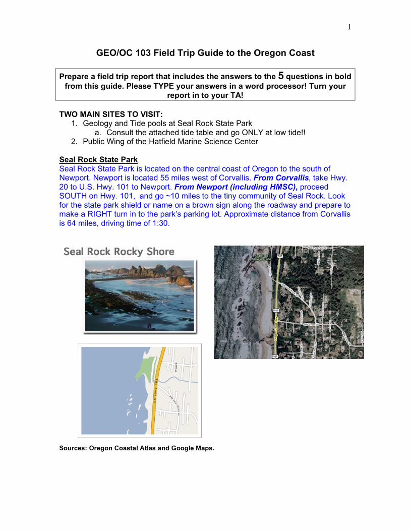
Seal Rock State Park Seal Rock State Park is located on the central coast of Oregon to the south of Newport. Newport is located 55 miles west of Corvallis. From Corvallis, take Hwy. 20 to U.S. Hwy. 101 to Newport. From Newport (including HMSC), proceed SOUTH on Hwy. 101, and go ~10 miles to the tiny community of Seal Rock. Look for the state park shield or name on a brown sign along the roadway and prepare to make a RIGHT turn in to the park’s parking lot. Approximate distance from Corvallis is 64 miles, driving time of 1:30.
Sources: Oregon Coastal Atlas and Google Maps.
2
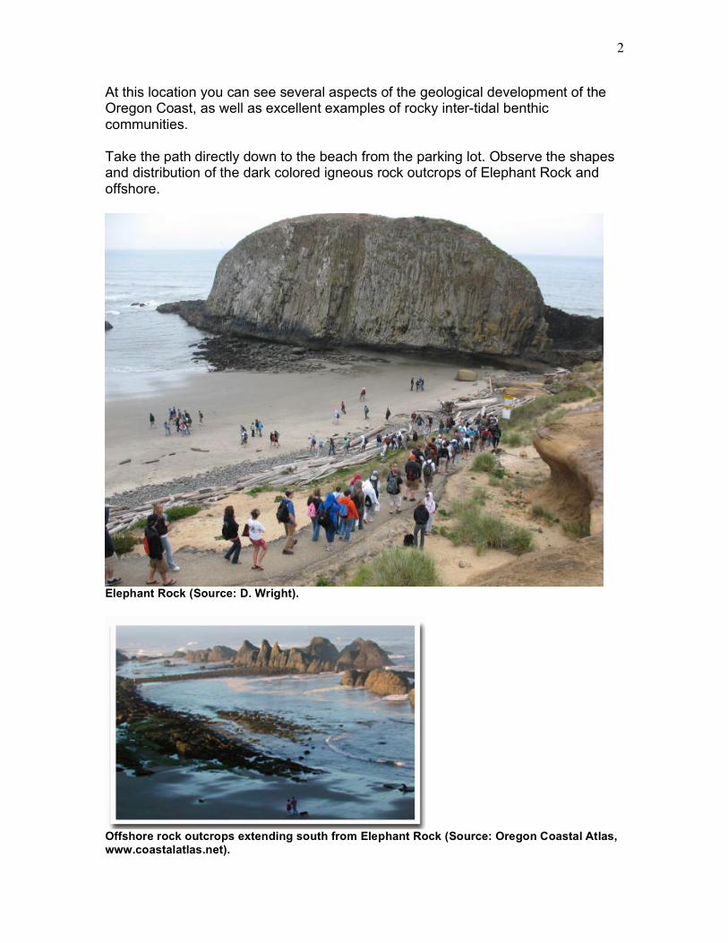
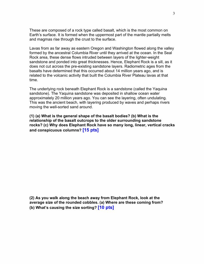
At this location you can see several aspects of the geological development of the Oregon Coast, as well as excellent examples of rocky inter-tidal benthic communities. Take the path directly down to the beach from the parking lot. Observe the shapes and distribution of the dark colored igneous rock outcrops of Elephant Rock and offshore.
Elephant Rock (Source: D. Wright).
Offshore rock outcrops extending south from Elephant Rock (Source: Oregon Coastal Atlas, www.coastalatlas.net).
3
These are composed of a rock type called basalt, which is the most common on Earth’s surface. It is formed when the uppermost part of the mantle partially melts and magmas rise through the crust to the surface. Lavas from as far away as eastern Oregon and Washington flowed along the valley formed by the ancestral Columbia River until they arrived at the ocean. In the Seal Rock area, these dense flows intruded between layers of the lighter-weight sandstone and ponded into great thicknesses. Hence, Elephant Rock is a sill, as it does not cut across the pre-existing sandstone layers. Radiometric ages from the basalts have determined that this occurred about 14 million years ago, and is related to the volcanic activity that built the Columbia River Plateau lavas at that time. The underlying rock beneath Elephant Rock is a sandstone (called the Yaquina sandstone). The Yaquina sandstone was deposited in shallow ocean water approximately 20 million years ago. You can see the layering, often undulating. This was the ancient beach, with layering produced by waves and perhaps rivers moving the well-sorted sand around. (1) (a) What is the general shape of the basalt bodies? (b) What is the relationship of the basalt outcrops to the older surrounding sandstone rocks? (c) Why does Elephant Rock have so many long, linear, vertical cracks and conspicuous columns? [15 pts] (2) As you walk along the beach away from Elephant Rock, look at the average size of the rounded cobbles. (a) Where are these coming from? (b) What’s causing the size sorting? [10 pts]
4
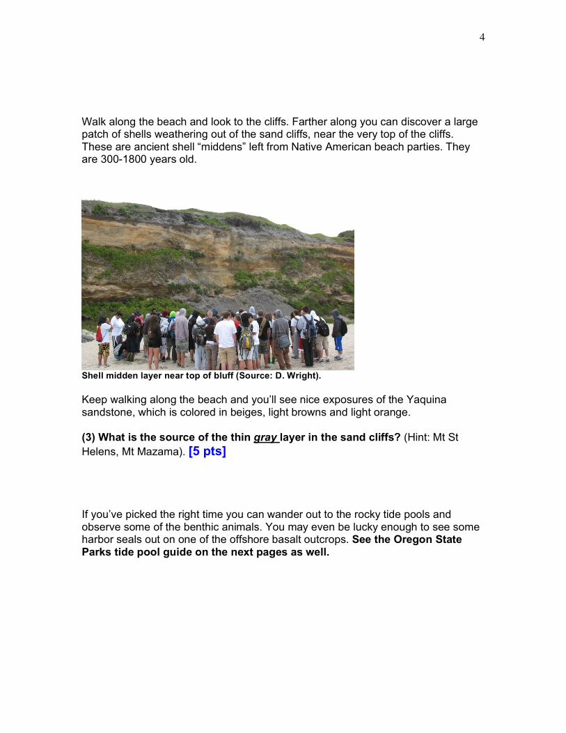
Walk along the beach and look to the cliffs. Farther along you can discover a large patch of shells weathering out of the sand cliffs, near the very top of the cliffs. These are ancient shell “middens” left from Native American beach parties. They are 300-1800 years old.
Shell midden layer near top of bluff (Source: D. Wright). Keep walking along the beach and you’ll see nice exposures of the Yaquina sandstone, which is colored in beiges, light browns and light orange. (3) What is the source of the thin gray layer in the sand cliffs? (Hint: Mt St Helens, Mt Mazama). [5 pts] If you’ve picked the right time you can wander out to the rocky tide pools and observe some of the benthic animals. You may even be lucky enough to see some harbor seals out on one of the offshore basalt outcrops. See the Oregon State Parks tide pool guide on the next pages as well.
Please leave plants and animals just as you found them. State parks are nature preserves, where all living things are protected for others to enjoy.
www.oregonstateparks.org
This publication is available in alternative formats on request. Write to OPRD, 725 Summer St. NE Suite C,
Salem, OR 97301; or call (503) 986-0707 (for the hearing impaired 1-800-735-2900).
Printed on recycled paper
63400-8136 (6/08)
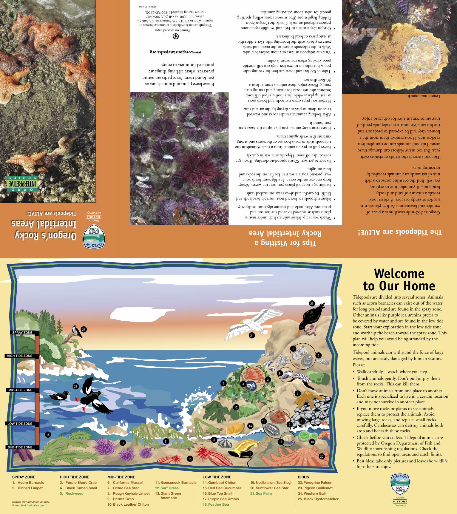
The Tidepools are ALIVE!
Oregon’s 362-mile coastline is a place of wonder and fascination. At first glance, it is a series of sandy beaches. A closer look reveals a mixture of sand and rocky headlands. If you take time to explore, you will find the coastline home to a rich mix of extraordinary animals revealed by retreating tides.
Tidepools attract thousands of visitors each year. But too many visitors can damage these areas. Tidepool animals can be trampled by a careless step. If you remove them from their homes, they will be exposed to predators and the hot sun. We must treat tidepools gently if they are to remain alive for others to enjoy.
Tidepools are divided into several zones. Animals such as acorn barnacles can exist out of the water for long periods and are found in the spray zone. Other animals like purple sea urchins prefer to be covered by water and are found in the low tide zone. Start your exploration in the low tide zone and work up the beach toward the spray zone. This plan will help you avoid being stranded by the incoming tide.
Tidepool animals can withstand the force of large waves, but are easily damaged by human visitors. Please:
• Walkcarefully—watchwhereyoustep.
• Touchanimalsgently.Don’tpullorprythemfrom the rocks. This can kill them.
• Don’tmoveanimalsfromoneplacetoanother.Each one is specialized to live in a certain location and may not survive in another place.
• Ifyoumoverocksorplantstoseeanimals, replace them to protect the animals. Avoid moving large rocks, and replace small rocks carefully. Carelessness can destroy animals both atop and beneath these rocks.
• Checkbeforeyoucollect.Tidepoolanimalsareprotected by Oregon Department of Fish and Wildlife sport fishing regulations. Check the regulations to find open areas and catch limits.
• Bestidea:takeonlypicturesandleavethewildlifefor others to enjoy.
Welcome to Our Home
spray zone
1. acorn Barnacle
2. ribbed Limpet
HigH Tide zone
3. purple shore Crab
4. Black Turban snail
5. rockweed
Mid-Tide zone
6. California Mussel
7. ochre sea star
8. rough Keyhole Limpet
9. Hermit Crab
10. Black Leather Chiton
11. gooseneck Barnacle
12. surf grass
13. giant green anemone
Low Tide zone
14. gumboot Chiton
15. red sea Cucumber
16. Blue Top snail
17. purple sea Urchin
18. Feather Boa
19. nudibranch (sea slug)
20. sunflower sea star
21. sea palm
Birds
22. peregrine Falcon
23. pigeon guillemot
24. western gull
25. Black oystercatcher
Tips for Visiting a Rocky Intertidal Area
•Watchyourstep.Manyanimalshideundermarineplants such as seaweed to avoid the hot sun and predators. Also, rocks and marine algae can be slippery.
•Manytidepoolsarelocatednearunstableheadlandsandbluffs. Be careful and always stay on marked trails.
•Exploringatidepoolplacesyounearthewaves.Alwayskeep one eye on the ocean. If a big wave heads your way, pretend you’re a sea star. Lie flat on the rocks and hold on tight.
•Expecttogetwet.Wearappropriateclothing.Ifyougetsoaked, dry off soon. Hypothermia sets in quickly.
•Neverpullorpryananimalfromarock.Animalsinthetidepools stick to rocks because of the waves and strong currents that wash against them.
•Pleasereturnanyanimalyoupickuptotheexactspotyou found it.
•Afterlookingatanimalsunderrocksandseaweed, re-cover them to prevent drying by the air and sun.
•Harborsealpupsoftenuserocksandbeachareasas resting places while their mothers feed offshore. Seabirds also use rocks for nesting and rearing their young. Please enjoy these animals from at least a 50-foot distance.
•Tidesof0.0feetandlowerarebestforvisitingtide-pools, but tides up to two feet high can still provide good viewing when the ocean is calm.
•Visitthetidepoolsatleastonehourbeforelowtide.Walk to the tidepools closest to the ocean and work your way back with the incoming tide. Get a tide table at state parks or local businesses.
•OregonDepartmentofFishandWildliferegulationsprotect tidepool animals. Check the Oregon Sport Fishing Regulations (free at most stores selling sporting goods) for rules about collecting animals.
spray zone
high tide zone
Mid-tide zone
Low tide zone
sub-tide zone
22
23
18
17 21
15
19
12
5 4
14
10
16
9
8
20
13
11
7
3
6
1
2
24
25
Brown text indicates animal.Green text indicates plant.
INTERPRETIVE SerieS
OPrD
Lemon nudibranch
5
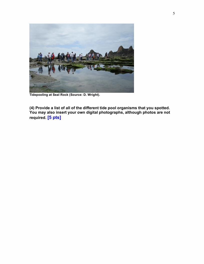
Tidepooling at Seal Rock (Source: D. Wright). (4) Provide a list of all of the different tide pool organisms that you spotted. You may also insert your own digital photographs, although photos are not required. [5 pts]
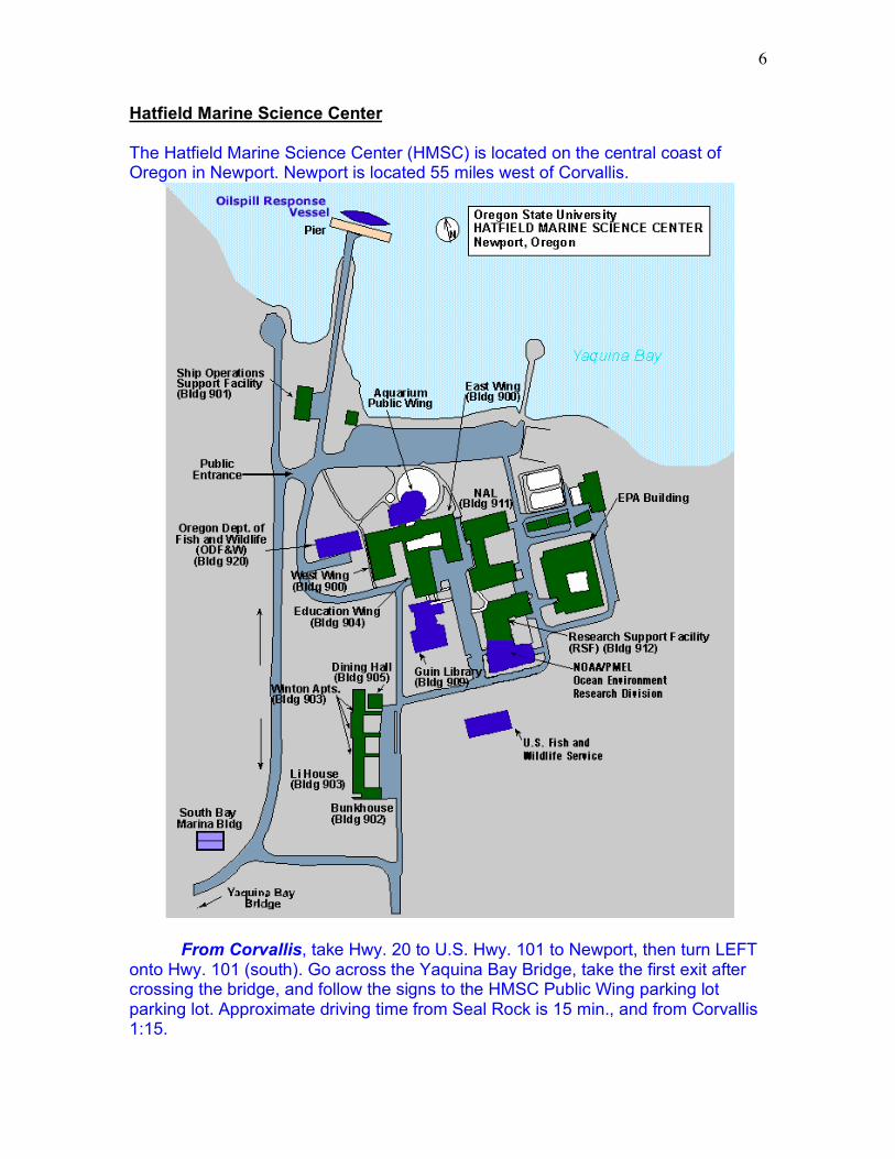
6
Hatfield Marine Science Center The Hatfield Marine Science Center (HMSC) is located on the central coast of Oregon in Newport. Newport is located 55 miles west of Corvallis.
From Corvallis, take Hwy. 20 to U.S. Hwy. 101 to Newport, then turn LEFT onto Hwy. 101 (south). Go across the Yaquina Bay Bridge, take the first exit after crossing the bridge, and follow the signs to the HMSC Public Wing parking lot parking lot. Approximate driving time from Seal Rock is 15 min., and from Corvallis 1:15.
7
From Seal Rock, turn LEFT on to Hwy. 101 (to go north). Just before reaching the Yaquina Bay Bridge, you'll see the signs for your exit to the Visitor Center to the right. Follow the signs to the HMSC Public Wing parking lot. From Yaquina Head turn RIGHT on to Hwy. 101 (to go south). Approximate distance from Corvallis is 54 miles, driving time of 1:10. OSU’s Hatfield Marine Science Center (HMSC) is a research and teaching facility located in Newport, Oregon on the Yaquina Bay estuary, about one mile from the open waters of the Pacific Ocean. The HMSC plays an integral role in programs of marine and estuarine research and instruction, as a laboratory facility serving resident scientists, as a base for far-ranging oceanographic studies, and as a classroom for students. It has research facilities that support investigations in marine fisheries, aquaculture, water quality, marine biology, botany, microbiology, zoology and oceanography. The Center is well equipped with appropriate specialized instruments, constant temperature rooms, computer equipment, etc. Wet laboratories are provided with running fresh and seawater. Meeting rooms and lecture rooms are located in close proximity to the laboratories. OSU researchers are resident at HMSC of course, but there are also facilities occupied by the National Oceanic and Atmospheric Administration (NOAA), the U.S. Fish and Wildlife Service (USFWS), the Oregon Department of Fish and Wildlife (ODFW), and Environmental Protection Agency (EPA). Spend about an hour looking at the various exhibits throughout visitor center, including the Resource Room and the octopus and touch tanks (those attending the regularly scheduled field trip will also be treated to a special presentations in the auditorium). See the visitor center map below.
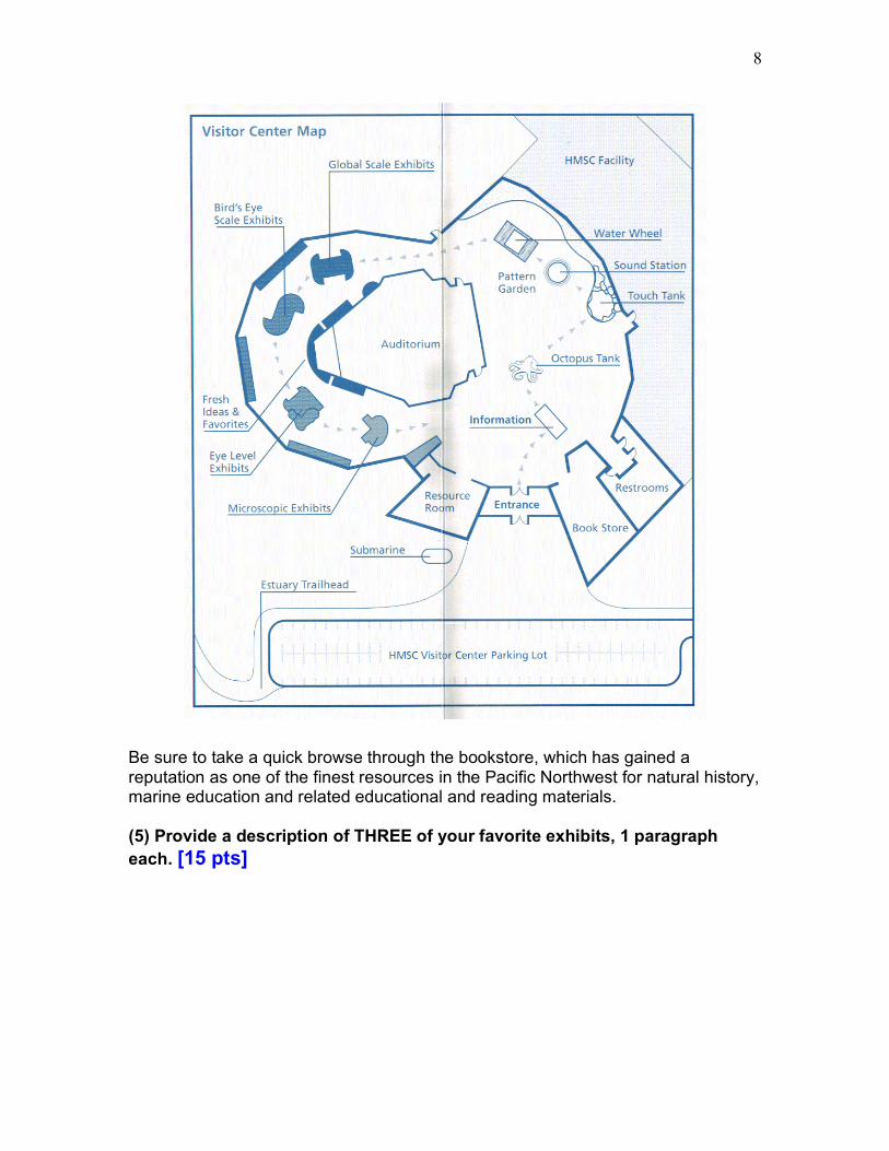
8
Be sure to take a quick browse through the bookstore, which has gained a reputation as one of the finest resources in the Pacific Northwest for natural history, marine education and related educational and reading materials. (5) Provide a description of THREE of your favorite exhibits, 1 paragraph each. [15 pts]
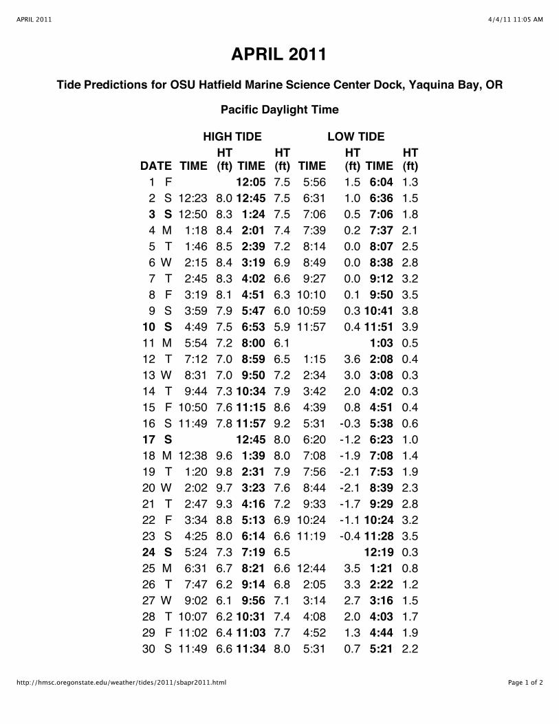
4/4/11 11:05 AMAPRIL 2011
Page 1 of 2http://hmsc.oregonstate.edu/weather/tides/2011/sbapr2011.html
APRIL 2011Tide Predictions for OSU Hatfield Marine Science Center Dock, Yaquina Bay, OR
Pacific Daylight Time
HIGH TIDE LOW TIDE
DATE TIMEHT(ft) TIME
HT(ft) TIME
HT(ft) TIME
HT(ft)
1 F 12:05 7.5 5:56 1.5 6:04 1.32 S 12:23 8.0 12:45 7.5 6:31 1.0 6:36 1.53 S 12:50 8.3 1:24 7.5 7:06 0.5 7:06 1.84 M 1:18 8.4 2:01 7.4 7:39 0.2 7:37 2.15 T 1:46 8.5 2:39 7.2 8:14 0.0 8:07 2.56 W 2:15 8.4 3:19 6.9 8:49 0.0 8:38 2.87 T 2:45 8.3 4:02 6.6 9:27 0.0 9:12 3.28 F 3:19 8.1 4:51 6.3 10:10 0.1 9:50 3.59 S 3:59 7.9 5:47 6.0 10:59 0.3 10:41 3.8
10 S 4:49 7.5 6:53 5.9 11:57 0.4 11:51 3.911 M 5:54 7.2 8:00 6.1 1:03 0.512 T 7:12 7.0 8:59 6.5 1:15 3.6 2:08 0.413 W 8:31 7.0 9:50 7.2 2:34 3.0 3:08 0.314 T 9:44 7.3 10:34 7.9 3:42 2.0 4:02 0.315 F 10:50 7.6 11:15 8.6 4:39 0.8 4:51 0.416 S 11:49 7.8 11:57 9.2 5:31 -0.3 5:38 0.617 S 12:45 8.0 6:20 -1.2 6:23 1.018 M 12:38 9.6 1:39 8.0 7:08 -1.9 7:08 1.419 T 1:20 9.8 2:31 7.9 7:56 -2.1 7:53 1.920 W 2:02 9.7 3:23 7.6 8:44 -2.1 8:39 2.321 T 2:47 9.3 4:16 7.2 9:33 -1.7 9:29 2.822 F 3:34 8.8 5:13 6.9 10:24 -1.1 10:24 3.223 S 4:25 8.0 6:14 6.6 11:19 -0.4 11:28 3.524 S 5:24 7.3 7:19 6.5 12:19 0.325 M 6:31 6.7 8:21 6.6 12:44 3.5 1:21 0.826 T 7:47 6.2 9:14 6.8 2:05 3.3 2:22 1.227 W 9:02 6.1 9:56 7.1 3:14 2.7 3:16 1.528 T 10:07 6.2 10:31 7.4 4:08 2.0 4:03 1.729 F 11:02 6.4 11:03 7.7 4:52 1.3 4:44 1.930 S 11:49 6.6 11:34 8.0 5:31 0.7 5:21 2.2
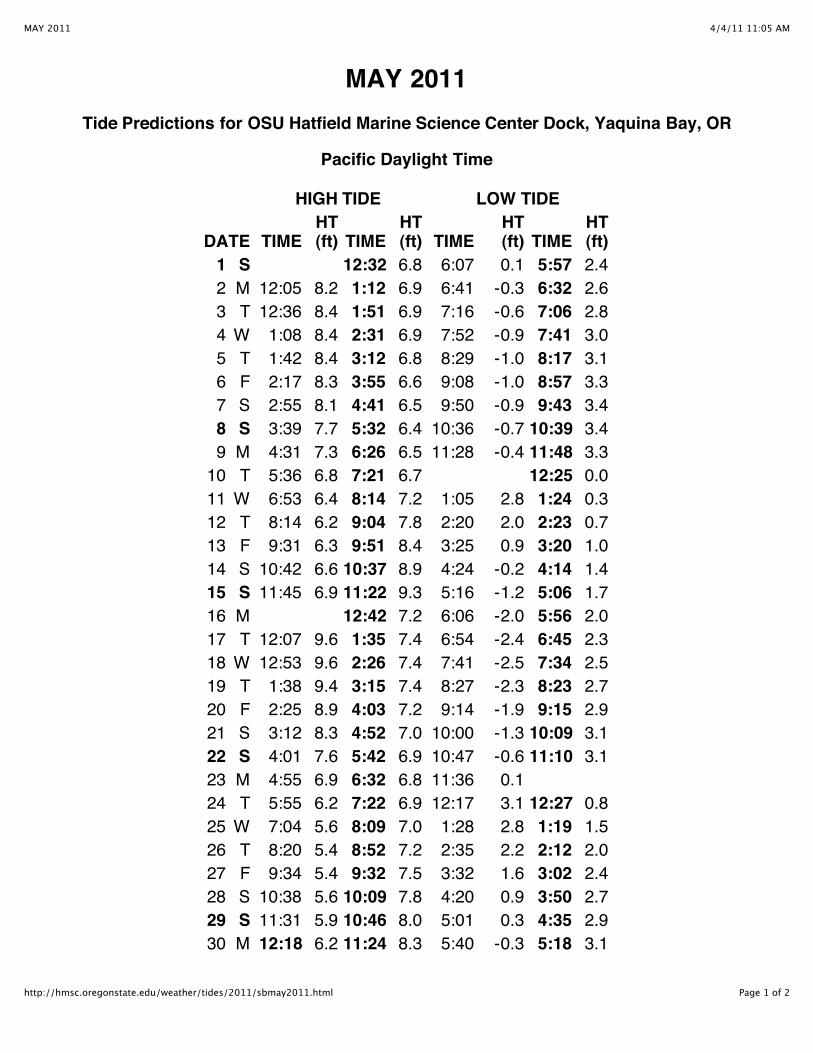
4/4/11 11:05 AMMAY 2011
Page 1 of 2http://hmsc.oregonstate.edu/weather/tides/2011/sbmay2011.html
MAY 2011Tide Predictions for OSU Hatfield Marine Science Center Dock, Yaquina Bay, OR
Pacific Daylight Time
HIGH TIDE LOW TIDE
DATE TIMEHT(ft) TIME
HT(ft) TIME
HT(ft) TIME
HT(ft)
1 S 12:32 6.8 6:07 0.1 5:57 2.42 M 12:05 8.2 1:12 6.9 6:41 -0.3 6:32 2.63 T 12:36 8.4 1:51 6.9 7:16 -0.6 7:06 2.84 W 1:08 8.4 2:31 6.9 7:52 -0.9 7:41 3.05 T 1:42 8.4 3:12 6.8 8:29 -1.0 8:17 3.16 F 2:17 8.3 3:55 6.6 9:08 -1.0 8:57 3.37 S 2:55 8.1 4:41 6.5 9:50 -0.9 9:43 3.48 S 3:39 7.7 5:32 6.4 10:36 -0.7 10:39 3.49 M 4:31 7.3 6:26 6.5 11:28 -0.4 11:48 3.310 T 5:36 6.8 7:21 6.7 12:25 0.011 W 6:53 6.4 8:14 7.2 1:05 2.8 1:24 0.312 T 8:14 6.2 9:04 7.8 2:20 2.0 2:23 0.713 F 9:31 6.3 9:51 8.4 3:25 0.9 3:20 1.014 S 10:42 6.6 10:37 8.9 4:24 -0.2 4:14 1.415 S 11:45 6.9 11:22 9.3 5:16 -1.2 5:06 1.716 M 12:42 7.2 6:06 -2.0 5:56 2.017 T 12:07 9.6 1:35 7.4 6:54 -2.4 6:45 2.318 W 12:53 9.6 2:26 7.4 7:41 -2.5 7:34 2.519 T 1:38 9.4 3:15 7.4 8:27 -2.3 8:23 2.720 F 2:25 8.9 4:03 7.2 9:14 -1.9 9:15 2.921 S 3:12 8.3 4:52 7.0 10:00 -1.3 10:09 3.122 S 4:01 7.6 5:42 6.9 10:47 -0.6 11:10 3.123 M 4:55 6.9 6:32 6.8 11:36 0.124 T 5:55 6.2 7:22 6.9 12:17 3.1 12:27 0.825 W 7:04 5.6 8:09 7.0 1:28 2.8 1:19 1.526 T 8:20 5.4 8:52 7.2 2:35 2.2 2:12 2.027 F 9:34 5.4 9:32 7.5 3:32 1.6 3:02 2.428 S 10:38 5.6 10:09 7.8 4:20 0.9 3:50 2.729 S 11:31 5.9 10:46 8.0 5:01 0.3 4:35 2.930 M 12:18 6.2 11:24 8.3 5:40 -0.3 5:18 3.1
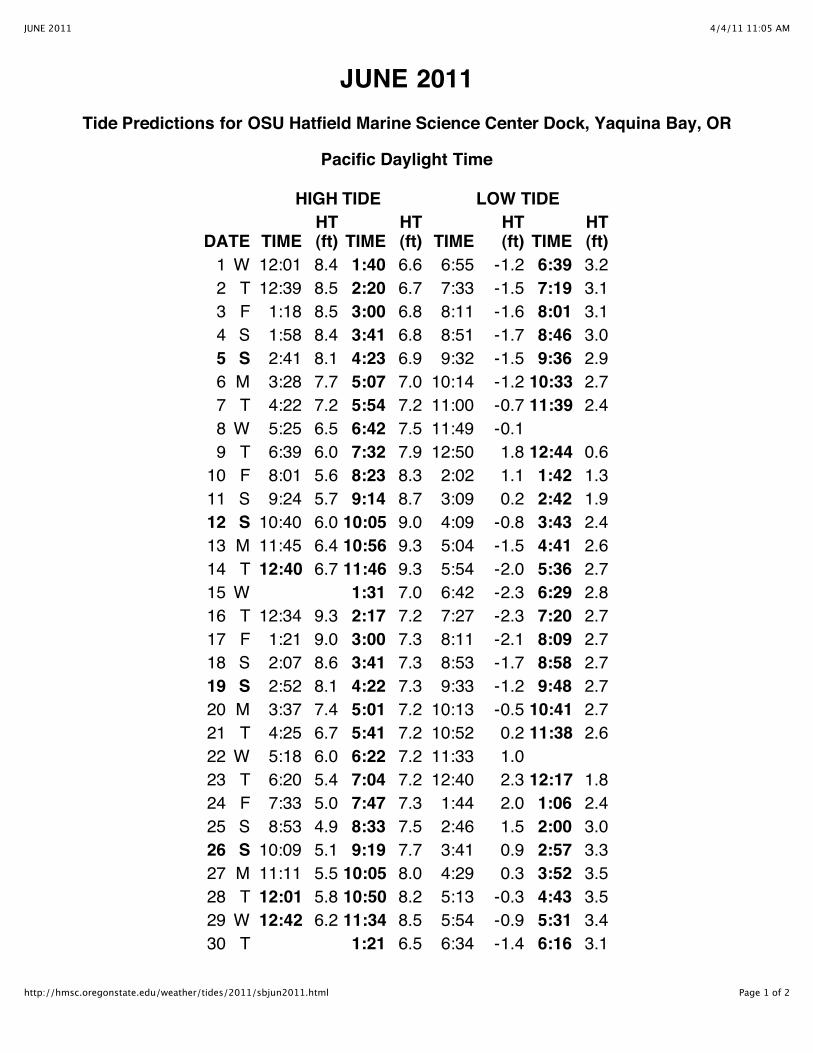
4/4/11 11:05 AMJUNE 2011
Page 1 of 2http://hmsc.oregonstate.edu/weather/tides/2011/sbjun2011.html
JUNE 2011Tide Predictions for OSU Hatfield Marine Science Center Dock, Yaquina Bay, OR
Pacific Daylight Time
HIGH TIDE LOW TIDE
DATE TIMEHT(ft) TIME
HT(ft) TIME
HT(ft) TIME
HT(ft)
1 W 12:01 8.4 1:40 6.6 6:55 -1.2 6:39 3.22 T 12:39 8.5 2:20 6.7 7:33 -1.5 7:19 3.13 F 1:18 8.5 3:00 6.8 8:11 -1.6 8:01 3.14 S 1:58 8.4 3:41 6.8 8:51 -1.7 8:46 3.05 S 2:41 8.1 4:23 6.9 9:32 -1.5 9:36 2.96 M 3:28 7.7 5:07 7.0 10:14 -1.2 10:33 2.77 T 4:22 7.2 5:54 7.2 11:00 -0.7 11:39 2.48 W 5:25 6.5 6:42 7.5 11:49 -0.19 T 6:39 6.0 7:32 7.9 12:50 1.8 12:44 0.610 F 8:01 5.6 8:23 8.3 2:02 1.1 1:42 1.311 S 9:24 5.7 9:14 8.7 3:09 0.2 2:42 1.912 S 10:40 6.0 10:05 9.0 4:09 -0.8 3:43 2.413 M 11:45 6.4 10:56 9.3 5:04 -1.5 4:41 2.614 T 12:40 6.7 11:46 9.3 5:54 -2.0 5:36 2.715 W 1:31 7.0 6:42 -2.3 6:29 2.816 T 12:34 9.3 2:17 7.2 7:27 -2.3 7:20 2.717 F 1:21 9.0 3:00 7.3 8:11 -2.1 8:09 2.718 S 2:07 8.6 3:41 7.3 8:53 -1.7 8:58 2.719 S 2:52 8.1 4:22 7.3 9:33 -1.2 9:48 2.720 M 3:37 7.4 5:01 7.2 10:13 -0.5 10:41 2.721 T 4:25 6.7 5:41 7.2 10:52 0.2 11:38 2.622 W 5:18 6.0 6:22 7.2 11:33 1.023 T 6:20 5.4 7:04 7.2 12:40 2.3 12:17 1.824 F 7:33 5.0 7:47 7.3 1:44 2.0 1:06 2.425 S 8:53 4.9 8:33 7.5 2:46 1.5 2:00 3.026 S 10:09 5.1 9:19 7.7 3:41 0.9 2:57 3.327 M 11:11 5.5 10:05 8.0 4:29 0.3 3:52 3.528 T 12:01 5.8 10:50 8.2 5:13 -0.3 4:43 3.529 W 12:42 6.2 11:34 8.5 5:54 -0.9 5:31 3.430 T 1:21 6.5 6:34 -1.4 6:16 3.1