Embed Size (px)
Citation preview

_____________________________________________________________________________________________________ *Corresponding author: E-mail: [email protected];
Journal of Geography, Environment and Earth Science International 11(1): 1-12, 2017; Article no.JGEESI.34674 ISSN: 2454-7352
Geomorphometric Parameters of Ikpa River and its Implications for the Planning of Fluvial Hazards in
the Northeast of Akwa Ibom State
M. N. Ezemonye1, Ikpong S. Umo1,2*, C. C. Ojinma2, M. C. Ike2
and A. Iweka Enwereuzor2
1Department of Geography and Regional Planning, University of Benin, Nigeria. 2Department of Geography and Environmental Studies, Alvan Ikoku Federal College Education,
Owerri, Nigeria.
Authors’ contributions
This work was carried out in collaboration between all authors. Author MNE designed the statistical analysis and managed literature searches. Author ISU wrote the first draft of the manuscript,
performed the statistical analysis and wrote the protocol. Authors CCO, MCI and AIE managed the typing of the manuscript of the study and managed the literature searches. All authors read and
approved the final manuscript.
Article Information
DOI: 10.9734/JGEESI/2017/34674 Editor(s):
(1) Wen-Cheng Liu, Department of Civil and Disaster Prevention Engineering, National United University, Taiwan and Taiwan Typhoon and Flood Research Institute, National United University, Taipei, Taiwan.
(2) Zeyuan Qiu, Department of Chemistry and Environmental Sciences, New Jersey Institute of Technology, USA. Reviewers:
(1) P. A. Azeez, India Salim Ali Centre for Ornithology and Natural History, India. (2) Riad Hosein, University of the West Indies, Trinidad and Tobago.
(3) Angelo Paone, Università degli Studi di Napol, Italy. Complete Peer review History: http://www.sciencedomain.org/review-history/20068
Received 29 th October 2016 Accepted 2 nd June 2017
Published 15 th July 2017
ABSTRACT This article examines the geomorphometry of Ikpa River as a major determinant of the planning pattern for fluvial hazards in the Northeast of Akwa Ibom State. Geomorphometric parameters were computed for the entire area and the seven sub-basins sampled within the main watershed. A descriptive analysis of the parameters indicates that the dendritic Ikpa Watershed is a natural river with homogenous geologic formation and possesses high degree of integration of the smaller rivers. Sixteen geomorphometric parameters were measured for the seven sub-basins. Using Principal Component Analysis, four major geomorphometric parameters were identified and they
Original Research Article
Ezemonye et al.; JGEESI, 11(1): 1-12, 2017; Article no.JGEESI.34674
2
explained 96.8 percent of the total variance. The four components were texture (34.6%), areal (33.2%), shape (19.0%) and form (10.0%)}. Relationships were sought among four variables using multiple regression model. Result of the multiple coefficient of determination (R) yielded 0.997, with the adjusted R of 0.982, which explained 98.2 percent of the proportion of variance in the series. The findings imply that the prevailing flood and erosion in the Ikpa River basin is associated with its geomorphometry. We recommend appropriate monitoring of the forms and processes; and the establishment of dam at the confluence of the fourth order sub-basin to regulate flood and other water-induced hazards associated with the downstream region of the watershed.
Keywords: Ikpa River; geomorphometry; planning; fluvial hazards; dam project.
1. INTRODUCTION The evolution of landforms in a drainage basin is usually the outcome of interactions between the flows of matter and energy, and the nature of topographical surface [1-2]. The determination of interrelations especially between or among some critical geomorphometric parameters (relief, aerial, texture, form, shape etc.), are indispensable for appropriate water and land resource planning, with manageable negative geomorphic responses in the future as a result of dam construction and allied works. Geomorphometry is the measurement and analysis of whole or specific surface features defined by one or more processes, and separated from adjacent parts of the land surface according to clear criteria of delimitation [Evans cited in [3]. Basin geomorphometry therefore is concerned with the application of the knowledge of geomorphometry in the determination of geometry and dimension of landform in a river basin. This is inevitable with the recent increase in incidence of flood, erosion and other fluvio-geomorphologic hazards. Consequently, the International Geomorphological Union [4] has emphasized the need for in-depth quantitative studies of river basins that are not gauged, regardless of their sizes to reveal and define more clearly their real nature, than can be done by areal inspections. Despite the above observations, researches on the geomorphometric and fluvial potentials of many basins in Akwa Ibom State and other parts of the Niger Delta are as yet not given the required attention. Besides, attempts made to determine the complex interactions among critical geomorphometric parameters that account for most variations in the medium size drainage basins are few [5-7]. We believe that a better understanding of the morphological relationships that exist in the basin can aid the regulation of fluvial hazards such as flood and erosion that are prevalent in most basin areas.
In the humid tropical environment of Akwa Ibom State, where Ikpa River is located, the variability of rainfall amounts and storm surges have posed severe threat to life, property and environmental security, resulting from flood, erosion and other process-induced disasters [8-9]. The movement of water and sediment in a drainage basin determine the discharge rate over a period of time. In many instances, such mobile agents are presumably influenced by certain dimensional and dimensionless geomorphometric parameters. What may not have been properly determined is the exact nature of relationships that exist between geomorphometric parameters in most basins of southern Nigeria. This has motivated case studies to explore relationships while stressing the need to clarify obvious ambiguity in the parameterization of basins. In various river basins of the world, varying parameters have been identified and used in the explanations of such relationships, although some of these parameters tend to be redundant or abandoned in some researches. In Jordan, [10] computed twenty-six morphometric parameters (including basin area, length, perimeter, density, texture etc) for Zerqa River using ASTER DEM and ArcGIS software to 43 derived sub-basins. Principal Component Analysis was used with other statistical methods to reduce the 26parameters into six major components which accounted for 79.3% of the total variance explained by the original morphometric variables. Their study suggested that morphometric analysis can be employed in flash floods risk and floods hazard assessment for the basin and other river catchments. Similarly [11] studied dams comprising of 19%, 9.8% and 6.4% of total relief in the three corresponding drainage basins in Corvallis (USA). A comparison of stream-gradient-contributing-area and parameter values was
Ezemonye et al.; JGEESI, 11(1): 1-12, 2017; Article no.JGEESI.34674
3
estimated from field data. Their findings suggested a strong effect of network structure, which varied significantly among the sites, profile, shape and relief due to the effects of relatively immobile wood and boulders deposited in the valley by debris-flows. In Himalayan region of India, [12] studied the discharge behaviour of Lidder River Basin. Analysis of basin using geospatial technique revealed that the entire area has uniform lithology and was structurally permeable (coarse texture). From integrated analysis of morphometric parameters, important hydrologic behaviour of the 17 sampled watersheds was inferred. They concluded that the basin area was highly prone to weathering, flooding, erosion and landslide. Altaf et al. [13] studied the morphological and hydrological characteristics of Maros River in Hungary using DEM (ArcGIS) software with a horizontal resolution of 2 m. The result showed maximum discharge of 2655 m3/s; minimum discharge 27 m3/s in the region of misfit paleo-channel and a mean channel slope value (31.0 mkm-1) and others. They concluded that morphology of the basin channel played vital role in water/sediment transportation and aggradation of alluvial fan. In Eastern India, [14] studied 18 morphometric parameters of Kushkarani River Basin using data that were developed from Toposheets(SOI), satellite imageries and SRTM DEM of United States Geological Survey (USGS).Out of total river basin only 11% area comes under highly diversified surface and maximum part of the area comes under quite monotonous surface with least variation. Their model results indicated that the highly diversified surface was prone to rills and gully erosion. Khatun and Pal [15] studied the morphometric and hydrological implications of Ajani and Jhiri River Basin in Maharashtra, India. Their results revealed that hydrological response of the sampled watersheds changed in response to spatial variations in morphometric parameters. Also, network analysis showed an increased in 1st and 2nd order but decreased in 4th and 5th order streams. They concluded that discharge behaviours were independent of structural control of both Ajani and Jhiri River Basin. Within the North-eastern Nigeria, [16] examined the relationship between drainage basin area and stream length for Gongola (Adamawa) River.
They used power equation in the analyzing the two parameters. Their findings affirmed a postulation that drainage area and stream length are related in a power function. They emphasized the need for comparative studies of drainage basin with similar geometric, climatic and hydrologic conditions. In western Nigeria, [17] examined the morphometric characteristics of Oba river drainage basin in the South-west of Nigeria with the use of GIS. Descriptive analyses revealed that the 6th order basin has a total stream length of 2754.48 km, stream number of 2979, basin length of 96.1km while basin area and perimeter were 2494.45 km2 and 291 km respectively. They concluded that results obtained were helpful for determining the tendency for flood events in the watershed. From the preceding review, there are clear indications that each drainage basin may vary based on the prevalent geologic, topographic, climatic and other characteristics [18], thereby influencing their geomorphometric relationships differently. It is being suspected that differences in the choice of geomorphometric parameters have raised a number of issues such as which parameter(s) enhance the understanding of a basin evolution and which parameter(s) account for major influence on the landscape or hydrological planning of a basin. These in effect have motivated the researchers to carry out this study on the Ikpa River Basin of Akwa Ibom State. 1.1 Aim and Objectives of the Study The aim of this study is to analyze the relationships among distinct geomorphometric parameters of Ikpa River Basin in Akwa Ibom State, Nigeria. To achieve this aim, the following specific objectives are investigated.
1. To examine the nature of geomorphometry of Ikpa River Basin in Akwa Ibom State.
2. To determine the correlations among geomorphometric parameters of Ikpa River Basin in Akwa Ibom State.
3. To assess the implications of findings on the fluvial hazard planning within the basin area.
1.2 Hypothesis This paper is built on a null hypothesis that:“there are no significant correlations among basin area,
Ezemonye et al.; JGEESI, 11(1): 1-12, 2017; Article no.JGEESI.34674
4
stream length, stream number, perimeter, average bifurcation ratio, basin density, length of overland flow, stream frequency, basin intensity, circularity ratio, elongation ratio, relative ratio, relief ratio, mean altitude, mean stream length and form factor in Ikpa River Basin”.
2. DESCRIPTION OF THE STUDY AREA
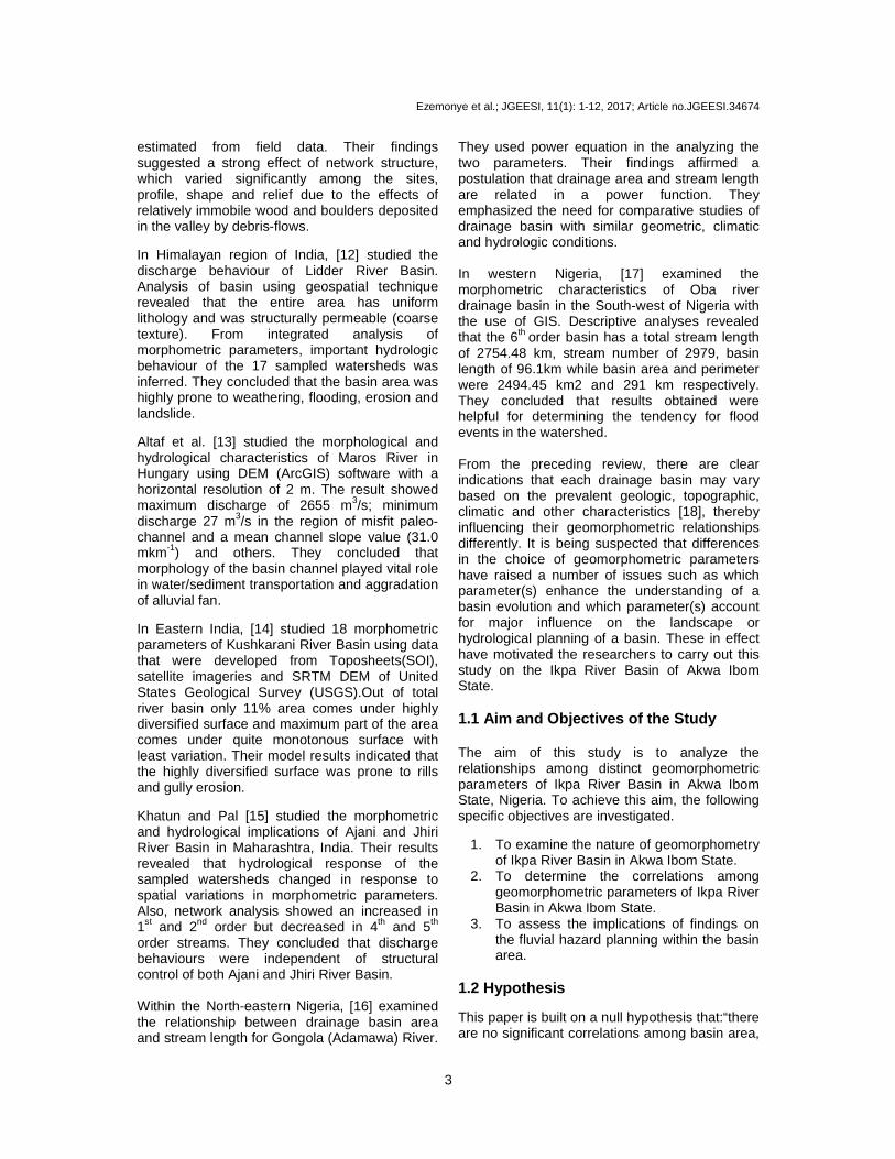
2.1 Locations The Ikpa River is a major tributary of the Cross River. It is found in the Northeast Akwa Ibom State, East Niger Delta of Nigeria. Absolutely, the Ikpa River Basin is located between longitude 7°46 134.9ll and 8°3 111.9l1, East of Greenwich Meridian and latitudes 5°0 13.801l1 and 5°16 149.12911, North of the Equator.
2.2 Climate, Geology and Relief Climate of the study area is humid Tropic (Af) climate. It has a mean annual rainfall of 2443.3 mm with double maxima based on rainfall data of 1977 to 2013. The rainy season lasts between the months of April to October and its peak in July, while the dry season falls between the months of November to May annually (see e.g. [8] and [9]). The short dry season usually occur in the month of August and is popularly known as August break and often last for two weeks. The
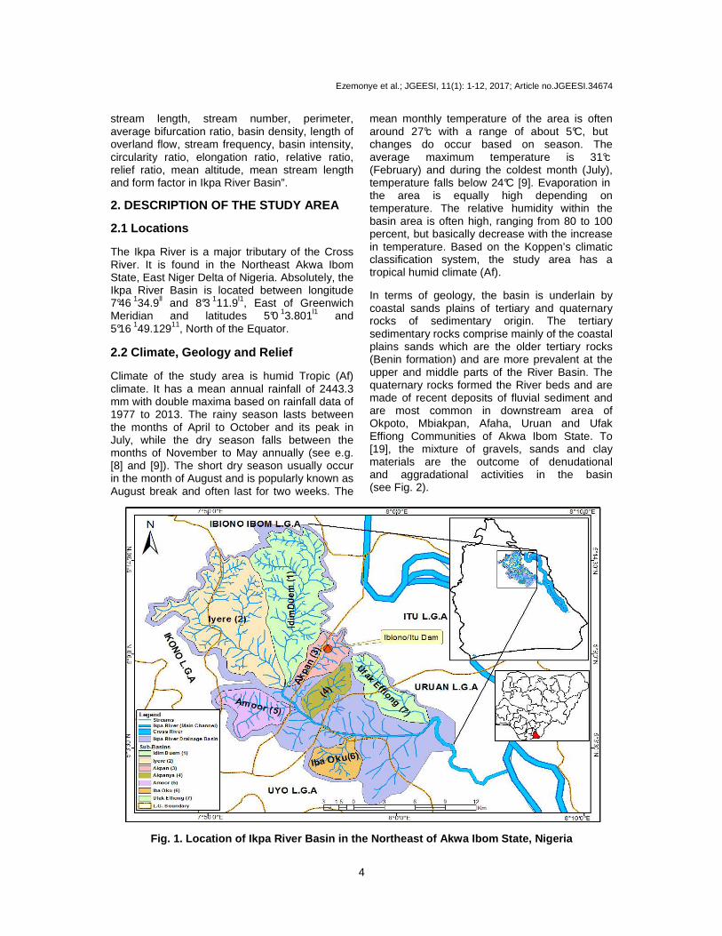
mean monthly temperature of the area is often around 27°c with a range of about 5°C, but changes do occur based on season. The average maximum temperature is 31°c (February) and during the coldest month (July), temperature falls below 24°C [9]. Evaporation in the area is equally high depending on temperature. The relative humidity within the basin area is often high, ranging from 80 to 100 percent, but basically decrease with the increase in temperature. Based on the Koppen’s climatic classification system, the study area has a tropical humid climate (Af). In terms of geology, the basin is underlain by coastal sands plains of tertiary and quaternary rocks of sedimentary origin. The tertiary sedimentary rocks comprise mainly of the coastal plains sands which are the older tertiary rocks (Benin formation) and are more prevalent at the upper and middle parts of the River Basin. The quaternary rocks formed the River beds and are made of recent deposits of fluvial sediment and are most common in downstream area of Okpoto, Mbiakpan, Afaha, Uruan and Ufak Effiong Communities of Akwa Ibom State. To [19], the mixture of gravels, sands and clay materials are the outcome of denudational and aggradational activities in the basin (see Fig. 2).
Fig. 1. Location of Ikpa River Basin in the Northeast of Akwa Ibom State, Nigeria
Ezemonye et al.; JGEESI, 11(1): 1-12, 2017; Article no.JGEESI.34674
5
Fig. 2. Relief of Ikpa River Drainage Basin (Extracted from USGS DEM [20]) The relief of the basin varies from one location to another. However, geomorphometric analysis using United State Geological Survey (USGS DEM, 2016) and ArcGIS software indicate that the highest elevation (483 meters) is in a Town called Obotme, Ini Local Government Area, where the Ikpa River originated and flows North-south to South-west direction into the Cross River as shown in Fig. 2. 3. METHODOLOGY AND DATA Data on sixteen basin geomorphometric parameters were computed from four topographic sheets of Ikot Ekpene (sheet 322 NE); Ikot Ekpene (Sheet 322 SE); Uwet (Sheet 323 SW); and Calabar (Sheet 331 NW) each produced on a scale of 1:50,000 by the Federal Survey Department in Nigeria. The drainage basin was digitized and extracted with the used of Geographic Information System (GIS) environment, while map of the study area was extracted (USGS DEM). The drainage basin was delineated according to Strahler ordering scheme [21,22], to form the basis for this geomorphometric analysis. The first part of sampling in drainage basin entails demarcating the networks. A blue-line crenulation method was used in support of analogue maps. Using GIS, stream segments were ordered numerically as order 1 starting from the basin’s head waters to a confluence of the two fourth-orders [Fig. 2]. In
Strahler scheme [21], two first-order stream segments join to form a second-order stream. Similarly, two second-order streams join to form a third-order stream and so on [1,17] and [23]. A total of seven (five 3rd and two 4th order) sub-basins were selected using stratified sampling technique to represent the Ikpa River System. This is because geomorphologists and other earth scientists often consider third-order basin and above as well matured for geomorphometric studies [see [8,13], and the immensity of the entire basin justifies the use of probability sampling. Geomorphometric data generated from topographic maps and GIS software environment are analyzed descriptively to examine the nature of the entire Ikpa River (see formula for each geomorphometric parameter in Table 1 attached as appendix). Also, multivariate statistics (Principal Component Analysis (PCA) is used to identify a pattern of relationships. Its rationale is to reduce the sixteen geomorphometric parameters into few major variables based on their relationship with each other and removed those variables that are redundant. Multiple linear regression is used to evaluate the strength of relationships among the geomorphometric parameters selected for this study. Its rationale is to determine the proportion of variance explained by variables in the model. Analysis of Variance (ANOVA) is used to test for significance of the
Ezemonye et al.; JGEESI, 11(1): 1-12, 2017; Article no.JGEESI.34674
6
association among distinct geomorphometric parameters in the series. Statistical Packages for Social Sciences (SPSS) version 17.0 is used for statistical analyses. 4. RESULTS AND DISCUSSION 4.1 Description of the Nature of Ikpa
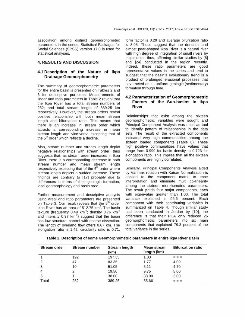
Drainage Geomorphometry The summary of geomorphometric parameters for the entire basin is presented on Tables 2 and 3 for descriptive purposes. Measurements of linear and ratio parameters in Table 2 reveal that the Ikpa River has a total stream numbers of 252; and total stream length of 389.25 km respectively. However, the stream orders reveal positive relationship with both mean stream length and bifurcation ratio. This means that there is an increase in stream order which attracts a corresponding increase in mean stream length and vice-versa excepting that of the 5th order which reflects a decline. Also, stream number and stream length depict negative relationships with stream order, thus suggests that, as stream order increases in Ikpa River, there is a corresponding decrease in both stream number and mean stream length respectively excepting that of the 5th order where stream length depicts a sudden increase. These findings are contrary to [17] probably due to differences in terms of their geologic formation, local geomorphology and basin area. Further measurement and descriptive analysis using areal and ratio parameters are presented on Table 3. Our result reveals that the 5th order Ikpa River has an area of 512.75 km2. The basin texture {frequency 0.49 km-1; density 0.76 km-1 and intensity 0.37 km-2} suggest that the basin has low structural control with coarse dissection. The length of overland flow offers 0.67 km. The elongation ratio is 1.42, circularity ratio is 0.71,
form factor is 0.29 and average bifurcation ratio is 3.95. These suggest that the dendritic and almost pear-shaped Ikpa River is a natural river with high degree of integration of small rivers by major ones; thus, affirming similar studies by [8] and [24] conducted in the region recently. Indeed, these ratio parameters are good representative values in the series and tend to suggest that the basin’s evolutionary trend is a product of prolonged erosional processes that have acted on its uniform geologic (sedimentary) formation through time. 4.2 Parameterization of Geomorphometric
Factors of the Sub-basins in Ikpa River
Relationships that exist among the sixteen geomorphometric variables were sought and Principal Component Analysis was used as tool to identify pattern of relationships in the data sets. The result of the extracted components indicated very high communalities among the sixteen loaded components (Table 6). These high positive communalities have values that range from 0.999 for basin density to 0.723 for elongation ratio. This implies that all the sixteen components are highly correlated. Similarly, Principal Components Analysis aided by Varimax rotation with Kaiser Normalization is applied to the component matric to ease interpretation and eliminate multi co-linearity among the sixteen morphometric parameters. The result yields four major components, each with eigenvalue greater than 1.00. The total variance explained is 96.6 percent. Each component with their contributing variables is summarized on Table 4. Though similar study had been conducted in Jordan by [10], the difference is that their PCA only reduced 26 geomorphometric parameters into six main components that explained 79.3 percent of the total variance in the series.
Table 2. Description of some Geomorphometric parameters in entire Ikpa River Basin
Stream order Stream number Stream length
(km) Mean stream length (km)
Bifurcation ratio
1 192 197.35 1.03 = = = 2 47 83.35 1.77 4.09 3 10 51.05 5.11 4.70 4 2 19.50 9.75 5.00 5 1 38.00 38.00 2.00 Total 252 389.25 55.66 = = =
Ezemonye et al.; JGEESI, 11(1): 1-12, 2017; Article no.JGEESI.34674
7
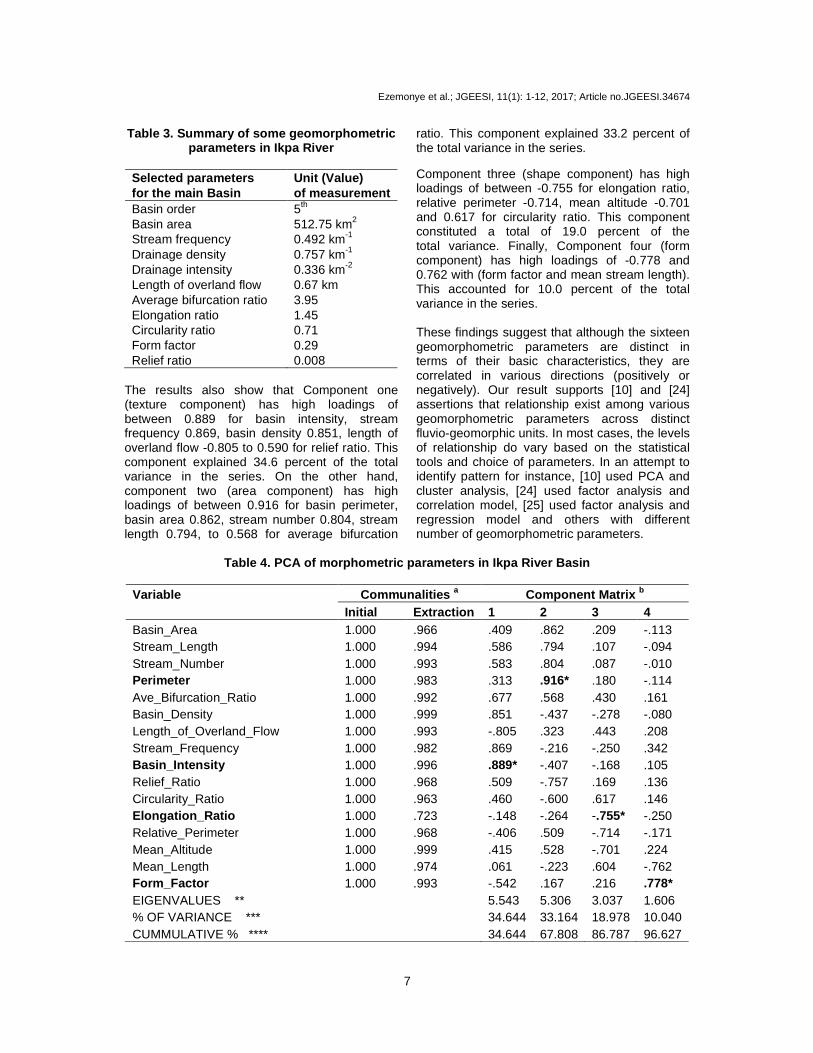
Table 3. Summary of some geomorphometric parameters in Ikpa River
Selected parameters for the main Basin
Unit (Value) of measurement
Basin order 5th Basin area 512.75 km2 Stream frequency 0.492 km-1 Drainage density 0.757 km-1 Drainage intensity 0.336 km-2 Length of overland flow 0.67 km Average bifurcation ratio 3.95 Elongation ratio 1.45 Circularity ratio 0.71 Form factor 0.29 Relief ratio 0.008
The results also show that Component one (texture component) has high loadings of between 0.889 for basin intensity, stream frequency 0.869, basin density 0.851, length of overland flow -0.805 to 0.590 for relief ratio. This component explained 34.6 percent of the total variance in the series. On the other hand, component two (area component) has high loadings of between 0.916 for basin perimeter, basin area 0.862, stream number 0.804, stream length 0.794, to 0.568 for average bifurcation
ratio. This component explained 33.2 percent of the total variance in the series. Component three (shape component) has high loadings of between -0.755 for elongation ratio, relative perimeter -0.714, mean altitude -0.701 and 0.617 for circularity ratio. This component constituted a total of 19.0 percent of the total variance. Finally, Component four (form component) has high loadings of -0.778 and 0.762 with (form factor and mean stream length). This accounted for 10.0 percent of the total variance in the series. These findings suggest that although the sixteen geomorphometric parameters are distinct in terms of their basic characteristics, they are correlated in various directions (positively or negatively). Our result supports [10] and [24] assertions that relationship exist among various geomorphometric parameters across distinct fluvio-geomorphic units. In most cases, the levels of relationship do vary based on the statistical tools and choice of parameters. In an attempt to identify pattern for instance, [10] used PCA and cluster analysis, [24] used factor analysis and correlation model, [25] used factor analysis and regression model and others with different number of geomorphometric parameters.
Table 4. PCA of morphometric parameters in Ikpa River Basin
Variable Communalities a Component Matrix b
Initial Extraction 1 2 3 4 Basin_Area 1.000 .966 .409 .862 .209 -.113 Stream_Length 1.000 .994 .586 .794 .107 -.094 Stream_Number 1.000 .993 .583 .804 .087 -.010 Perimeter 1.000 .983 .313 .916* .180 -.114 Ave_Bifurcation_Ratio 1.000 .992 .677 .568 .430 .161 Basin_Density 1.000 .999 .851 -.437 -.278 -.080 Length_of_Overland_Flow 1.000 .993 -.805 .323 .443 .208 Stream_Frequency 1.000 .982 .869 -.216 -.250 .342 Basin_Intensity 1.000 .996 .889* -.407 -.168 .105 Relief_Ratio 1.000 .968 .509 -.757 .169 .136 Circularity_Ratio 1.000 .963 .460 -.600 .617 .146 Elongation_Ratio 1.000 .723 -.148 -.264 -.755* -.250 Relative_Perimeter 1.000 .968 -.406 .509 -.714 -.171 Mean_Altitude 1.000 .999 .415 .528 -.701 .224 Mean_Length 1.000 .974 .061 -.223 .604 -.762 Form_Factor 1.000 .993 -.542 .167 .216 .778* EIGENVALUES ** 5.543 5.306 3.037 1.606 % OF VARIANCE *** 34.644 33.164 18.978 10.040 CUMMULATIVE % **** 34.644 67.808 86.787 96.627
Ezemonye et al.; JGEESI, 11(1): 1-12, 2017; Article no.JGEESI.34674
8
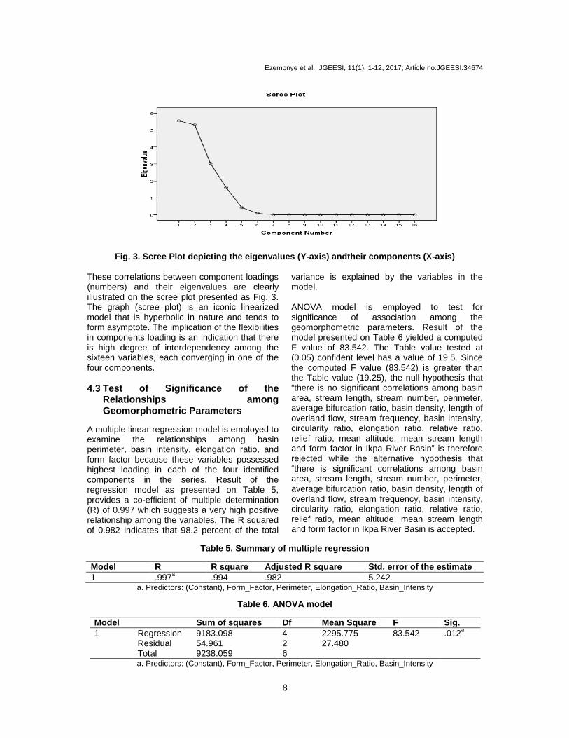
Fig. 3. Scree Plot depicting the eigenvalues (Y-axis) andtheir components (X-axis) These correlations between component loadings (numbers) and their eigenvalues are clearly illustrated on the scree plot presented as Fig. 3. The graph (scree plot) is an iconic linearized model that is hyperbolic in nature and tends to form asymptote. The implication of the flexibilities in components loading is an indication that there is high degree of interdependency among the sixteen variables, each converging in one of the four components. 4.3 Test of Significance of the
Relationships among Geomorphometric Parameters
A multiple linear regression model is employed to examine the relationships among basin perimeter, basin intensity, elongation ratio, and form factor because these variables possessed highest loading in each of the four identified components in the series. Result of the regression model as presented on Table 5, provides a co-efficient of multiple determination (R) of 0.997 which suggests a very high positive relationship among the variables. The R squared of 0.982 indicates that 98.2 percent of the total
variance is explained by the variables in the model. ANOVA model is employed to test for significance of association among the geomorphometric parameters. Result of the model presented on Table 6 yielded a computed F value of 83.542. The Table value tested at (0.05) confident level has a value of 19.5. Since the computed F value (83.542) is greater than the Table value (19.25), the null hypothesis that “there is no significant correlations among basin area, stream length, stream number, perimeter, average bifurcation ratio, basin density, length of overland flow, stream frequency, basin intensity, circularity ratio, elongation ratio, relative ratio, relief ratio, mean altitude, mean stream length and form factor in Ikpa River Basin” is therefore rejected while the alternative hypothesis that “there is significant correlations among basin area, stream length, stream number, perimeter, average bifurcation ratio, basin density, length of overland flow, stream frequency, basin intensity, circularity ratio, elongation ratio, relative ratio, relief ratio, mean altitude, mean stream length and form factor in Ikpa River Basin is accepted.
Table 5. Summary of multiple regression
Model R R square Adjusted R square Std. error of the estimate 1 .997a .994 .982 5.242
a. Predictors: (Constant), Form_Factor, Perimeter, Elongation_Ratio, Basin_Intensity
Table 6. ANOVA model
Model Sum of squares Df Mean Square F Sig. 1 Regression 9183.098 4 2295.775 83.542 .012a
Residual 54.961 2 27.480 Total 9238.059 6 a. Predictors: (Constant), Form_Factor, Perimeter, Elongation_Ratio, Basin_Intensity
Ezemonye et al.; JGEESI, 11(1): 1-12, 2017; Article no.JGEESI.34674
9
5. IMPLICATIONS OF FINDINGS ON THE PLANNING OF FLUVIAL HAZARD IN THE BASIN
Our descriptive analyses summarized as Tables 2 and 3 reveal that most of the Rivers located within the coastal plains sand deposits of the tertiary time and quaternary periods [19] in the Northeast of Akwa Ibom State, Nigeria, evolve through normal erosional processes; which according to [25] are directly linked with the nature of its climate and local geomorphology. The drainage network of the Ikpa River is dendritic and has been significantly influenced by geomorphic, climatic, lithologic, tectonic, structural and other factors. These make the area more vulnerable to erosion and flood hazards. Similarly, distinct geomorphometric parameters tend to exhibit strong positive or negative relationship with each other. The implication of these findings is that planning and policy formulations should be directed towards redressing the diverse human activities within the watershed especially in area of infrastructures (such as road, bridge, housing, irrigation, dam and others) which often alter the area, shape and form of the basin. This is very important as certain geomorphometric elements (stream length, basin area, elongation ratio and average bifurcation ratio) were found to exercise either very strong positive or negative influence on the evolutionary trends and other morphological/fluvial variables of the basin. Such cognizance through appropriate planning and management of the Ikpa River basin can enhance effective mitigation or control of the negative geomorphic responses prevailing in the basin area, which often affect the life span of roads, bridges, houses, farmlands and other socio-economic activities. Recently [8] and [9] have identified prolonged and torrential rainfall, anthropogenic interferences and other environmental factors as key issues that accelerate flooding, erosion and land sliding. Since development is a spatial process and may affect the proper functioning of a basin if not properly regulated. Table 4 reveals that drainage basin as a fundamental geomorphic system and planning unit operates based on natural principles. These principles are often measured using morphological attributes). Man bears the responsibility of applying caution in his actions to avert unwarranted damages and activation of a chain of negative reactions. This is very crucial especially when considering the real and
potential impacts of changing pattern of precipitation (as emphasized in [8] and [25]) on form-process within the vulnerable basin areas in Southern Nigeria given the flooding and erosion disasters. 6. CONCLUSION AND RECOMMENDA-
TIONS From the foregoing, the influences, variations and relationships between various geomorphometric parameters have been established. The study concludes that significant correlations exist among distinct geomorphometric parameters in Ikpa River Basin. This indicates that the prevailing flood, erosion and associated hazards in the area are mostly related to the basin geomorphometry .For instance, our analysis of the basin texture {frequency 0.49km-1; density 0.76km-1 and intensity 0.37km-2} indicate clearly that the basin has low structural control with coarse dissection. In another perspective, the elongation ratio of 1.42, circularity ratio of 0.71, form factor of 0.29 and average bifurcation ratio of3.9 suggest that the dendritic and almost pear-shaped Ikpa River is a natural river with high degree of integration of small rivers by major ones. This finding affirming similar studies by [26] and others conducted outside the basin. Indeed, our ratio parameters are good representative values in the series and tend to suggest that the basin’s evolutionary trend is a product of prolonged erosional processes that have acted on its uniform geologic (sedimentary) formation through time. In view of the findings reached and the implications discussed in the course of our work, this study recommends that Government, its agencies and non-governmental bodies should co-operate and establish appropriate gauging and other monitoring facilities for the entire Ikpa River Basin. If this properly done, it could provide the needed data that will enhance proper management and forecast of discharge behaviour and avert negative geomorphic responses in the basin area and its effect on people through prolonged flooding and erosional activities. Similarly, more researches should be conducted to evaluate the nature of interactions between critical geomorphometric parameters and hydrological processes in the area. We believe that such knowledge will enhance sustainable
Ezemonye et al.; JGEESI, 11(1): 1-12, 2017; Article no.JGEESI.34674
10
use of the basin as Nigeria’s heritage especially when considering the climate variability and change impacts in this 21st century. ACKNOWLEDGEMENT We sincerely acknowledge the contributions and supports of the three reviewers whose comments contributed immensely in improving the quality of this paper, and those from Mrs Agnes E. Umoren and Mr Obot Ibanga as well as other researchers whose works are referenced in this article. COMPETING INTERESTS Authors have declared that no competing interests exist. REFERENCES 1. Zavoianu I. Morphometry of drainage
basin. Amsterdam, Elsevier; 1985. 2. Maharaji VT, Wood LJ. A quantitative
paleo-geomorphic study of the fluvio-deltaic reservoirs in the Atoka Interval, Fort Worth, Texas. Gulf Coast Association of Geological Societies. 2009;59:495–509.
3. Jarvis RS, Clifford NJ. Specific geomorphometry. In A. Gouldie et al. (ed.) Geomorphological techniques. Produced for the British Geomorphological Research Group. Canada, Routledge. 1990;70–79.
4. International Geomorphological Union (IGU) Conference; 2012.
5. Aper JA. Stream discharge response to basin parameters in the Lower Benue River basin. Unpublished M.Sc. Thesis, University of Nigeria, Nsukka; 2000.
6. Aper JA. Stream discharge characteristic in the Lower Benue drainage basin. Unpublished Ph.D. thesis, University of Nigeria, Nsukka; 2006.
7. Effiong J. Drainage basin morphometry, land use and discharge in Calabar River basin, Cross River State, Nigeria. Unpublished Ph.D. thesis, University of Calabar; 2010.
8. Umo IS. Drainage Basin Morphometry and Discharge in Ikpa River, Akwa Ibom State, Nigeria. Unpublished MSc. Thesis, Department of Geography, University of Benin; 2014.
9. Udosen CE. Rainfall pattern in Iba Oku River Basin, Akwa Ibom State and Its Implication on Stream Flow Regimes. Journal of Scientific Research. 2012;2(2): 31-40.
10. Farhan Y, Elmaji I, Khalil O. GIS-based morphometric analysis of fourth-order sub- basins of the Zerqa River (Northern Jordan) using multivariate statistical techniques. Natural resources. 2016;7: 461-480. Available:http://dx.doi.org/10.4236/nr.2016.78040
11. Lancaster ST, Grant GE. Debris dam and the relief of headwater streams. Geomorphology. 2006;82:84–97.
12. Altaf F, Meraji G, Romshoo SA. Morphometric analysis to infer hydrological behaviour of Western Lidder River Basin, India; 2013. Available:http://www.dx.doi.org/10.115/2013/178021 (Retrieved on Jan. 2014)
13. Sumeghy B, Kiss T. Morphological and hydrological characteristics of paleo-channel on the alluvial fan of Maros River, Hungary. Journal of Environmental Geography. 2012;5(1-2):11–17.
14. Khatun S, Pal S. Categorization of morphometric surface through morphometric diversity analysis in Kushkarani River basin of Eastern India. Asian Journal of Physical and Chemical Sciences. 2017;2(1):1-19. DOI: 10.9734/AJOPACS/2017/31098
15. Golekar RB, Baride MV, Patil DN. Morphometric analysis and hydrological implication of Ajani and Jhiri River basin Maharashtra, India. Archives of Applied Science Research. 2013;5(2):33–41.
16. Oyegoke SO, Ifeadi C. Relationship between drainage area and stream length for River Gongola, Nigeria. The Pacific Journal of Science and Technology. 2007; 8(2):184-189.
17. Jesuleye IA, OkekeUH, Atijosan AO, Badru RA, Adewoyin JE, Alaga AT. Morphometry assessment of Oba river basin and its implications for flood. Journal of Geography, Environment and Earth Science International. 2016;8(3):1-10.
18. Umeuduji JE. Analysis of Drainage Basin Parameters in the Aboine, Nigeria. Seminar paper presented to the Department of Geography, University of Nigeria Nsukka. 1990.
19. Orajaka SO. Eastern Nigeria: Geology. In GEK Ofomata Nigeria in maps: Eastern States. Ethiope publishing house, Benin City, Nigeria; 1974: 5-10
20. United State Geological Survey.
Ezemonye et al.; JGEESI, 11(1): 1-12, 2017; Article no.JGEESI.34674
11
21. Strahler AN. Quantitative analysis of watershed geomorphology. Transactions of the American geophysical union. 1952; 38.
22. Strahler AN. Quantitative geomorphology of drainage basin and channels networks. In TV Chow (ed.) Hand book of applied hydrology. 1964;4-39.
23. Zăvoianu I. Relationships between suspended sediment load discharge and the total number and length of stream segments. Journal of Geography and Regional Planning. 2013;6(2):31-40.
24. Anyadike RNC, Phile-Eze PO. Response to basin parameters in southeastern Nigeria. Geografiska annaler series (A), physical geography. 1989;71(1):75- 84.
25. Udosen CE. Gully erosion in Ikpa river basin: A threshold phenomenon. Lagos, Time Communication; 2008.
26. Olomo RO. Modern comprehensive practical geography. Benin City, Ehispress; 2008.
27. Horton RE. Erosional development of streams and their drainage basins: Hydro-physical approach to quantitative geomorphology. GSA Bulletin. 1945;56: 275–370.
28. Miller VC. A quantitative geomorphic studyof drainage basin characteristics in the Clinch Mountain area, Virginia and Tennessee. Project NR 389042, Technical Report 3. New York: Columbia University, Department of Geology, ONR, Geography Branch; 1953.
Ezemonye et al.; JGEESI, 11(1): 1-12, 2017; Article no.JGEESI.34674
12
APPENDIX
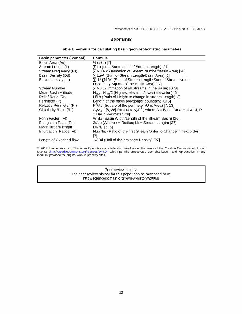
Table 1. Formula for calculating basin geomorphometric parameters
Basin parameter (Symbol) Formula Basin Area (Au) ¼ (a+b) [7] Stream Length (L) ∑ Lu (Lu = Summation of Stream Length) [27] Stream Frequency (Fs) ∑ Nu/A (Summation of Stream Number/Basin Area) [26] Basin Density (Dd) ∑ Lu/A (Sum of Stream Length/Basin Area) [1] Basin Intensity (Id) ∑ L*∑N /A2 (Sum of Stream Length*Sum of Stream Number
Divided by Square of the Basin Area) [27] Stream Number ∑ Nu (Summation of all Streams in the Basin) [GIS] Mean Basin Altitude Hmax – Hmin/2 (Highest elevation/lowest elevation) [6] Relief Ratio (Rr) H/Lb (Ratio of Height to change in stream Length) [8] Perimeter (P) Length of the basin polygon(or boundary) [GIS] Relative Perimeter (Pr) P2/Au (Square of the perimeter /Unit Area) [7, 13] Circularity Ratio (Rc) Ab/Ac [8, 26] Rc = (4 � A)/P2 ; where A = Basin Area, � = 3.14, P
= Basin Perimeter [28] Form Factor (Ff) Wb/Lb (Basin Width/Length of the Stream Basin) [26] Elongation Ratio (Re) 2r/Lb (Where r = Radius; Lb = Stream Length) [27] Mean stream length Lu/Nu [5, 6] Bifurcation Ratios (Rb) Nu1/Nu2 (Ratio of the first Stream Order to Change in next order)
[7] Length of Overland flow 1/2Dd (Half of the drainage Density) [27]
_________________________________________________________________________________ © 2017 Ezemonye et al.; This is an Open Access article distributed under the terms of the Creative Commons Attribution License (http://creativecommons.org/licenses/by/4.0), which permits unrestricted use, distribution, and reproduction in any medium, provided the original work is properly cited.
Peer-review history: The peer review history for this paper can be accessed here:
http://sciencedomain.org/review-history/20068