Embed Size (px)
Citation preview

Geomorphology is the Study of Landformsd th P th t C t Thand the Processes that Create Them,
Usually by Erosion, Transportation and Deposition
Fluvial = running water, rivers and floodplains
Glacial = flowing ice in cold environments, moraine
Aeolian = wind, usually in deserts, sand dunes
Sh li ti b h d liffShoreline = wave action, beach and cliff
Lacustrine = lakes are temporary features peat bogLacustrine lakes are temporary features, peat bog

Rivers Flood in a Perfectly Natural Process.Its Just Inconvenient for Peoplep

They Spend Billions $$$ Trying to Control RiversThey Spend Billions $$$ Trying to Control Rivers

The River Floods the Floodplain, the Flat Area on Either Side of the RiverEither Side of the River
So, people build levees to protect the floodplain

In Spite of All theIn Spite of All the Money Spent, They Still Flood When theStill Flood When the Big One Happens.

The Colorado River is One of the Most Manipulated Rivers
E h P i ilon Earth, Primarily for Water Supply for Growing Citiesfor Growing Cities and Agricultural Interests of theInterests of the Southwest.

Aeolian Processes Occur Primarily in DesertsAeolian Processes Occur Primarily in Deserts
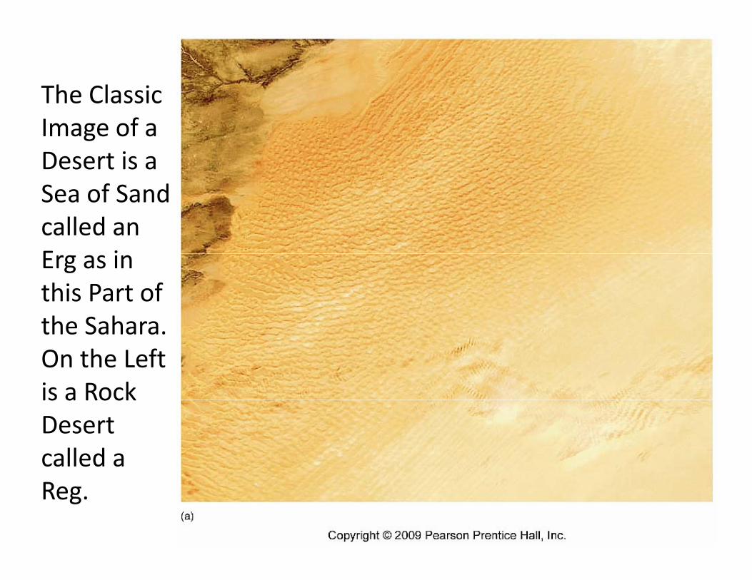
The Classic Image of a Desert is a Sea of Sand called an E iErg as in this Part of the Saharathe Sahara.On the Left is a Rockis a Rock Desert called a Reg.

Wi d CWinds Can Move Tons of Sand Each Day

The Exact Form of the Sand Dune Is Determined by Type/Amount of Sand and Type of Prevailing WindsType/Amount of Sand and Type of Prevailing Winds.
Transverse where winds prevail from
di i lone direction only
Parabolic where sand is anchored by vegetation

The Star Dune Forms Where the Direction of the Winds Change with the Seasons It Can LookWinds Change with the Seasons. It Can Look
Like a Starfish on an Air Photo

Sand Dunes Have Been Compared to Ocean Waves. Both are Formed by Wind y
But the Processes are Very Different

Action of Waves Along a Shoreline Can Erode Rock Making a Cliff and Deposit Sand Making a BeachMaking a Cliff and Deposit Sand Making a Beach

Coastal Landforms Are Usually Due to a C bi i f L l T h d W A iCombination of Local Topography and Wave Action


Two Types of Glaciers
Continental Glaciers Can Cover Thousands of Square Miles of Land to Depths of Thousands of Feet. The Antarctic Glacier and the Former North American Glacier Are Examples.
The Alpine Glacier is Smaller and Creates the Spectacular Landforms of Some Mountains.
Each Creates Their Own Characteristic Set of Landforms

18 Thousand Years Ago, This Glacier Covered 1/3 of the Continent Some Depths of Ice Were 2of the Continent. Some Depths of Ice Were 2 Miles Thick, Comparable to Antarctica Today

In the U.S., the Glacier Pushed South to the Ohio River and then Melted, Retreating Northward Leaving Glaciofluvial Landforms Including the Great Lakes

Glacialofluvial landforms Are Still Evident on the L d f thLandscape of the Mid‐west.

An Alpine Landscape Formed By Water Has a R d d S h ARounded, Smooth Appearance

Alpine Landscapes formed by Glaciers Has a Sharp Jagged Craggy AppearanceSharp Jagged, Craggy Appearance

The Horn is a Classic Feature of Alpine Gl iGlaciers

Alpine Glaciers Flow Slowly Down Valleys Until They Melt. They Erode and Transport
dTremendous Amounts of Rock and Soil called Till OftenSoil called Till. Often Till Is Deposited at the End of thethe End of the Glacier as a Terminal Moraine. These Can Be Hundreds of Feet Tall.

Moraines Are Deposits of Rock and Mud Scraped U d M d b Gl iUp and Moved by a Glacier.

Alpine LandscapesAlpine Landscapes Modified by Glacial Action Are InstantlyAction Are Instantly Recognizable. The Horn, U‐Shaped pValley and Hanging Valley All Examples.

The U‐Shaped Valley with Flat Bottom and Steep Sid W ll i Cl i F f Al i Gl iSide Walls is a Classic Feature of Alpine Glaciers

Yosemite National Park Is Famous for Its S l Gl i l L dfSpectacular Glacial Landforms.
The Valley Was Filled with Ice as High as the Cliff