Embed Size (px)
Citation preview

Page | 1
Geomorphology by Pmfias.com
Interior Of The Earth .................................................................... 1
Seismic waves ................................................................................... 3
Propagation of Earthquake Waves ........................................ 5
Earth’s Layers ................................................................................... 6
Earth Movements............................................................................ 8
Earth Movements – Exogenetic Forces .............................. 11
Continental Drift Theory - Tectonics .................................. 14
Convectional Current Theory – Tectonics ........................ 19
Paleomagnetism .......................................................................... 20
Concept of Sea Floor Spreading ............................................ 21
Plate Tectonics .............................................................................. 22
Plate Tectonics - Interaction of Plates ............................... 24
Comparison: Continental Drift – See Floor Spreading – Plate Tectonics .............................................................................. 27
Ocean - Ocean Convergence or The Island - Arc Convergence ................................................................................... 29
Continent - Ocean Convergence Or The Cordilleran Convergence ................................................................................... 32
Continent - Continent Convergence or The Himalayan Convergence ................................................................................... 35
Formation of Himalayans and Tibet .................................. 36
Continent – Arc Convergence or New Guinea Convergence ................................................................................... 39
Orogeny ............................................................................................ 39
Divergent boundary ................................................................... 44
Transcurrent boundary or transform edge ..................... 49
Important mountain ranges ................................................... 49
Volcanism ........................................................................................ 55
Volcanic Landforms .................................................................... 62
Volcanism Types – Exhalative, Effusive, Explosive and Subaqueous Volcanism ............................................................. 65
Hotspot Volcanism ...................................................................... 68
Earthquakes ................................................................................... 70
Seismic Waves or Earthquake Waves ................................ 71
Tsunami ........................................................................................... 73
2004 Indian Ocean Tsunami .................................................. 76
ROCKS - Different kinds of rocks ........................................... 79
Landforms and Cycle of Erosion ........................................... 84
Fluvial Erosional Landforms .................................................. 84
Fluvial Depositional Landforms............................................ 89
Karst Landforms and Cycle of Erosion ............................... 91
Marine Landforms and Cycle of Erosion............................ 92
Marine Erosional Landforms .................................................. 93
Marine Depositional Landforms ........................................... 93
Coastlines ......................................................................................... 94
Glacial Landforms and Cycle of Erosion ............................ 96
Glacial Erosional Landforms................................................... 97
Glacial Depositional Landforms ............................................ 97
Arid Landforms and Cycle of Erosion .................................. 98
Erosional Arid Landforms ........................................................ 98
Arid Depositional Landforms ............................................... 100
Lakes ............................................................................................... 102
Important Lakes on Earth ..................................................... 105
Plateau ........................................................................................... 108
Plateau Formation.................................................................... 108
Plateau Types .............................................................................. 109
Major plateaus of the World ................................................ 110
Interior Of The Earth
▪ The configuration of the surface of the earth is largely a product of the processes operating in the interior of the earth.
Exogenic as well as endogenic processes are
constantly shaping the landscape.
Why know about earth’s interior
Understanding of the earth's interior is essential to understand the nature of changes that take place over and below the earth's surface.
• To understand geophysical phenomenon
like volcanism, earthquakes etc..
• To understand the internal structure of various solar system objects
• To understand the evolution and present composition of atmosphere
• Future deep-sea mineral exploration etc.
Sources of information about the
interior
Direct Sources

Page | 4
waves called surface waves. These
waves move along the surface. ▪ The velocity of waves changes as they travel
through materials with different elasticity (stiffness) (Generally density with few
exceptions). The more elastic the material is, the higher is the velocity.
Their direction also changes as they reflect or refract when coming across materials with different densities.
▪ There are two types of body waves. They are
called P and S-waves.
Behavior of Earthquake Waves
• The earthquake waves are measured with
the help of a seismograph and are of three types—
1. the 'P' waves or primary waves (longitudinal nature),
2. secondary waves or 'S' waves (transverse in nature) while the
3. surface waves are long or ‘L’ waves.
• The velocity and direction of the earthquake waves undergo changes when the medium through which they are travelling changes.
• When an earthquake or underground nuclear test sends shock waves through the Earth, the cooler areas, which generally are rigid, transmit these waves at a higher velocity than the hotter areas.
Primary Waves (P waves)
• Also called as the longitudinal or compressional waves.
• Particles of the medium vibrate along the direction of propagation of the wave.
• P-waves move faster and are the first to arrive at the surface.
• These waves are of high frequency.
• They can travel in all mediums.
• Velocity of P waves in Solids > Liquids > Gases
• Their velocity depends on shear strength or elasticity of the material.
[We usually say that the speed of sound waves depends on density. But there are few exceptions. For example: Mercury (liquid metal) has density greater than Iron but speed of sound in mercury is lesser compared to that in iron. This is because the shear strength of mercury is very low (this is why mercury is liquid) compared to that of iron.]
• The shadow zone for ‘P’ waves is an area that corresponds to an angle between 1030 and 1420
• This gives clues about Solid inner core.
Secondary Waves (S waves)
• Also called as transverse or distortional waves.
• Analogous to water ripples or light waves.
• S-waves arrive at the surface with some time lag.
• A secondary wave cannot pass through liquids or gases.
• These waves are of high frequency waves.
• Travel at varying velocities (proportional to shear strength) through the solid part of the Earth's crust, mantle.
• The shadow zone of 'S' waves extends almost halfway around the globe from the earthquake's focus.
• The shadow zone for ‘S’ waves is an area that corresponds to an angle between 1030 and 1800
Page | 13
pressures controlled by wetting and drying cycles.
Unloading and Expansion
• Removal of overlying rock load because of continued erosion causes vertical pressure release with the result that the upper layers of the rock expand producing disintegration of rock masses.
• In areas of curved ground surface, arched fractures tend to produce massive sheets or exfoliation slabs of rock.
Granular Disintegration
• Rocks composed of coarse mineral grains commonly fall apart grain by grain or undergo granular disintegration.
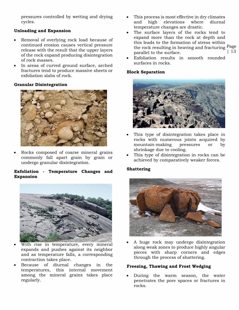
Exfoliation - Temperature Changes and Expansion
• With rise in temperature, every mineral expands and pushes against its neighbor and as temperature falls, a corresponding contraction takes place.
• Because of diurnal changes in the temperatures, this internal movement among the mineral grains takes place regularly.
• This process is most effective in dry climates and high elevations where diurnal temperature changes are drastic.
• The surface layers of the rocks tend to expand more than the rock at depth and this leads to the formation of stress within the rock resulting in heaving and fracturing parallel to the surface.
• Exfoliation results in smooth rounded
surfaces in rocks.
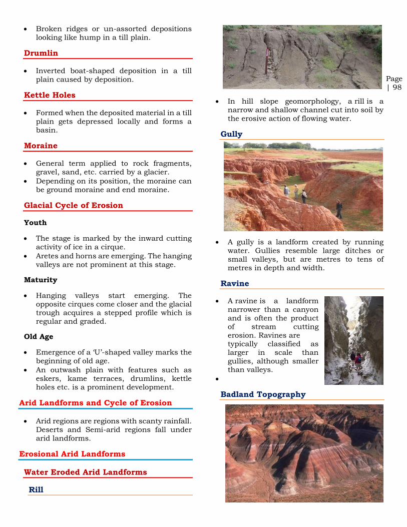
Block Separation
• This type of disintegration takes place in rocks with numerous joints acquired by mountain-making pressures or by shrinkage due to cooling.
• This type of disintegration in rocks can be achieved by comparatively weaker forces.
Shattering
• A huge rock may undergo disintegration along weak zones to produce highly angular pieces with sharp corners and edges through the process of shattering.
Freezing, Thawing and Frost Wedging
• During the warm season, the water penetrates the pore spaces or fractures in rocks.

Page | 21
• Periods of "normal" polarity (i.e., when the north-seeking end of the compass needle points toward the present north magnetic pole, as it does today) have alternated with periods of "reversed" polarity (when the north-seeking end of the compass needle points southward)[I have explained this in detail in the video].
• As today's magnetic field is close to the earth's rotational axis, continental drift could be tested by ascertaining the magnetic characteristics of ancient rocks.
Paleomagnetism: Strong evidence of See
Floor Spreading and Plate Tectonics
• Some of the strongest evidence in support of the theory of see floor spreading and plate tectonics comes from studying the magnetic fields surrounding oceanic ridges.
• Rocks formed from this underwater volcanic activity were mainly basalt, which is low silica, iron-rich, volcanic rock that makes up most of the ocean floor.
• Basalt contains magnetic minerals and as the rock is solidifying, these minerals align themselves in the direction of the magnetic field.
• This basically locks in a record of which way the magnetic field was positioned at the time that part of the ocean floor was created.
• Paleomagnetists [scientists who study past magnetic fields], took a look at the ocean floor going out away from oceanic ridges (either side of the oceanic ridges), they found magnetic stripes that were flipped so that one stripe would be normal polarity and the next reversed.
How could this be?
• These oceanic ridges were actually boundaries with tectonic plates pulling apart.
• This movement of the plates allowed the magma to rise up and harden into new rock.
• As the new rock was formed near the ridge, older rock, which formed millions of years ago when the magnetic field was reversed, got pushed farther away, resulting in this magnetic striping.
• Rising magma assumes the polarity of Earth’s geomagnetic field before it solidifies into oceanic crust.
• At spreading centres, this crust is separated into parallel bands of rock by successive waves of emergent magma.
• When Earth’s geomagnetic field undergoes a reversal, the change in polarity is recorded in the magma, which contributes to the alternating pattern of magnetic striping on the seafloor.
Concept
of Sea Floor Spreading
• The idea that the seafloor itself moves (and carries the continents with it) as it expands from a central axis was proposed by Harry Hess.
• According to this theory, the intense heat generated by radioactive substances in the mantle (100-2900 km below the earth
surface) seeks a path to escape, and gives
rise to the formation of convention currents in the mantle.
• Wherever rising limbs of these currents
meet, oceanic ridges are formed on the sea
floor and wherever the failing limbs meet,
trenches are formed.
• Seafloor spreading is a process that occurs at mid-ocean ridges, where new oceanic crust is formed through volcanic activity and then gradually moves away from the ridge.

Page | 31
• Central arc is formed due to the subduction of the Pacific Plate under the Philippine Plate (island formation is not significant along this arc). The trench formed is Izu Trench.
• Southern Arc is formed due to the subduction of the Philippine Plate under the Eurasian Plate. The trench formed is Ryukyu Trench.
• Japanese island arc was very close to the mainland.
• The force exerted by the Pacific plate and the Philippine plate tilted the arc towards its east giving rise to the Sea of Japan.
Explain the formation of thousands of
islands in Indonesian and Philippines
archipelagos
[20 marks - Mains 2014]
I suggest you to rely on mrunal.org answer key to know how to write an answer.
Archipelago: an extensive group of islands. [All the above mentioned ones and + few more]
Island arc: narrow chain of islands which are volcanic in origin. Island arc is usually curved. The convex side will have a trench if it’s an oceanic arc. Japan, Philippines, Hawaii etc. are oceanic arcs. Cascade range, Western Chile range etc. are examples of continental arcs.
Model Answer [May not be ideal, there is always scope for optimization] [I followed the formula 20 marks = 200 words]
• Indonesian archipelago and Philippine archipelago are located along the plate margins. Both the archipelagoes were formed due to ocean – ocean convergence.
• Indonesian archipelago was formed due to convergence between Sunda oceanic plate (part of Eurasian plate) and Indo – Australian plate whereas Philippine archipelago was formed due to convergence between Sunda oceanic plate and Philippine Sea plate. [if you can’t remember names, you should avoid these kind of points]
• In ocean – ocean convergence, two oceanic plates converge or collide. The denser plate subducts into the asthenosphere below the convergence zone and forms a trench at the
surface. This region below the convergence zone is called the zone of subduction.
• In the zone of subduction, due to high temperature and pressure, the rocks undergo metamorphosis and the sediments in the oceanic plate melt to form magma.
• The magma being lighter moves upwards. It is at high pressure due to the buoyant force offered by the surrounding denser medium. At the surface magma escapes in the form of volcanic eruptions.
• The magma solidifies creating a volcanic
layer. Subsequent volcanism builds layer over layer and a volcanic mountain if formed. Such mountains are formed all along the converging edge above the less denser plate.
• Over time the mountains merge and oceanic crust gets transformed into continental crust.
• And this is how Indonesian archipelago and Philippine archipelago are formed.
[Figure must for this answer]

Page | 90
Arcuate or Fan-shaped (Curved)
• This type of delta results when light depositions give rise to shallow, shifting distributaries and a general fan-shaped profile. Examples: Nile, Ganga, Indus.
Bird’s Foot Delta (Elongated)
• This type of delta emerges when limestone sediment deposits do not allow downward seepage of water.
• The distributaries seem to be flowing over projections of these deposits which appear as a bird’s foot.
• The currents and tides are weak in such
areas and the number of distributaries lesser as compared to an arcuate delta. Example: Mississippi river.
Estuaries
• Sometimes the mouth of the river appears to be submerged. This may be due to a drowned valley because of a rise in sea level.
• Here fresh water and the saline water get mixed. When the river starts ‘filling its mouth’ with sediments, mud bars, marshes and plains seem to be developing in it.
• These are ideal sites for fisheries, ports and industries because estuaries provide access to deep water, especially if protected from currents and tides. Example: Hudson estuary.
Cuspate Delta
• This is a pointed delta formed generally along strong coasts and is subjected to strong wave action. There are very few or no distributaries in a cuspate delta.
• Example: Tiber river on west coast of Italy.
High-constructive deltas – Elongate and Lobate Delta
Page | 98
• Broken ridges or un-assorted depositions looking like hump in a till plain.
Drumlin
• Inverted boat-shaped deposition in a till plain caused by deposition.
Kettle Holes
• Formed when the deposited material in a till plain gets depressed locally and forms a basin.
Moraine
• General term applied to rock fragments,
gravel, sand, etc. carried by a glacier.
• Depending on its position, the moraine can be ground moraine and end moraine.
Glacial Cycle of Erosion
Youth
• The stage is marked by the inward cutting activity of ice in a cirque.
• Aretes and horns are emerging. The hanging valleys are not prominent at this stage.
Maturity
• Hanging valleys start emerging. The opposite cirques come closer and the glacial trough acquires a stepped profile which is regular and graded.
Old Age
• Emergence of a ‘U’-shaped valley marks the beginning of old age.
• An outwash plain with features such as eskers, kame terraces, drumlins, kettle holes etc. is a prominent development.
Arid Landforms and Cycle of Erosion
• Arid regions are regions with scanty rainfall. Deserts and Semi-arid regions fall under arid landforms.
Erosional Arid Landforms
Water Eroded Arid Landforms
Rill
• In hill slope geomorphology, a rill is a narrow and shallow channel cut into soil by the erosive action of flowing water.
Gully
• A gully is a landform created by running water. Gullies resemble large ditches or small valleys, but are metres to tens of metres in depth and width.
Ravine
• A ravine is a landform narrower than a canyon and is often the product of stream cutting erosion. Ravines are typically classified as larger in scale than gullies, although smaller than valleys.
•
Badland Topography

Page
| 1
Climatology and Climatic
Regions by Pmfias.com
Jet streams ......................................................................................... 1
Air Masses .......................................................................................... 6
Fronts ................................................................................................... 8
Classification of Fronts................................................................. 9
Tropical Cyclones ......................................................................... 12
Temperate Cyclones or Extra Tropical Cyclones or Mid-Latitude Cyclones or Frontal Cyclones .............................. 25
Tropical Cyclones and Temperate Cyclones Comparison .............................................................................................................. 28
Polar Vortex ................................................................................... 29
Ozone Hole [Ozone Depletion at South Pole] .................. 31
El Nino .............................................................................................. 33
El Nino Southern Oscillation [ENSO] .................................. 35
Indian Ocean Dipole effect (Not every El Nino year is same in India)................................................................................ 36
El Niño Modoki ............................................................................. 36
La Nina ............................................................................................. 37
Koeppen’s scheme Of Classification Of Climate ............. 38
Tropical Wet Climate (Af) ....................................................... 39
Tropical Monsoon Climate ...................................................... 45
Savanna Climate or Tropical Wet and Dry Climate or Sudan Climate ............................................................................... 49
B: Desert Climate ......................................................................... 51
Steppe Climate or Temperate Continental Climate or Temperate Grassland Climate ............................................... 55
Mediterranean Climate or Warm Temperate Western Margin Climate or Warm Temperate West Coast Climate.............................................................................................. 59
Warm Temperate Eastern Margin Climate..................... 62
British Type Climate ................................................................... 65
Taiga Climate or Boreal Climate .......................................... 69
Laurentian Climate or Cool Temperate Eastern Marine Climate.............................................................................................. 72
Tundra Climate or Polar Climate or Arctic Climate .... 75
Jet streams
Geostrophic Wind
The velocity and direction of the wind are the net result of the wind generating forces.
The winds in the upper atmosphere, 2 - 3 km above the surface, are free from frictional effect of the surface and are controlled by the pressure gradient and the Coriolis force.
An air parcel initially at rest will move from high pressure to low pressure because of the Pressure Gradient Force (PGF).
However, as that air parcel begins to move, it is deflected by the Coriolis force to the right in the northern hemisphere (to the left in the southern hemisphere).
As the wind gains speed, the deflection increases until the Coriolis force equals the pressure gradient force (2 – 3 km above the ground, friction is low and winds travel at greater speeds).
At this point, the wind will be blowing parallel to the isobars (perpendicular to Pressure Gradient Force). When this happens, the wind is referred to as geostrophic wind.
Why winds don’t flow from tropical high pressure (in upper troposphere) to polar low (in upper troposphere) directly as shown in figure below?

Page
| 10
Once this boundary resumes its forward motion, becomes a warm front or cold front.
Weather along a stationary front
Cumulonimbus clouds are formed. Overrunning of warm air along such a front causes frontal precipitation.
Cyclones migrating along a stationary front can dump heavy amounts of precipitation, resulting in significant flooding along the front.
Cold and Warm Front Gif
Gif Images
Cold Front
Such a front is formed when a cold air mass replaces a warm air mass by advancing into it or that the warm air mass retreats and cold air mass advances (cold air mass is the clear winner).
In such a situation, the transition zone between the two is a cold front.
Cold front moves up to twice as quickly as warm fronts.
Frontolysis begin when the warm air mass is completely uplifted by the cold air mass.
Weather along a cold front
The weather along such a front depends on a narrow band of cloudiness and precipitation.
Severe storms can occur. During the summer months thunderstorms are common in warm sector.
In some regions like USA tornadoes occur in warm sector.
Produce sharper changes in weather. Temperatures can drop more than 15 degrees within the first hour.
Cloud formation along a cold front
The approach of a cold front is marked by increased wind activity in warm sector and the appearance of cirrus clouds, followed by lower, denser altocumulous and altostratus.

Page
| 16
countered by an opposing force called centrifugal force), the air in the vortex is forced to form a region of calmness called an eye at the center of the cyclone. The inner surface of the vortex forms the eye
wall, the most violent region of the cyclone.
[Eye is created due to tangential force acting on wind that is following a curvy path]
All the wind that is carried upwards loses its moisture and becomes cold and dense. It descends to the surface through the cylindrical eye region and at the edges of the cyclone.
Continuous supply of moisture from the sea is the major driving force behind every cyclone. On reaching the land the moisture supply is cut off and the storm dissipates.
If ocean can supply more moisture, the storm will reach a mature stage.
Mature stage
At this stage, the spiraling winds create multiple convective cells with successive calm and violent regions.
The regions with cumulonimbus cloud (rising limbs of convective cell) formation

Page
| 36
that of Port Darwin
Pressure high over eastern Pacific and low over
Reverse
Drought conditions in Eastern Pacific and good rainfall in Western Pacific (Northern Australia and Indonesia)
Reverse
Good for Indian Monsoons Bad for Indian Monsoons
Indian Ocean Dipole effect (Not
every El Nino year is same in India)
Although ENSO was statistically effective in explaining several past droughts in India, in the recent decades the ENSO-Monsoon relationship seemed to weaken in the Indian subcontinent. For e.g. the 1997, strong ENSO failed to cause drought in India.
However, it was later discovered that just like ENSO was an event in the Pacific Ocean, a similar seesaw ocean-atmosphere system in the Indian Ocean was also at play. It was discovered in 1999 and named the Indian Ocean Dipole (IOD).
The Indian Ocean Dipole (IOD) is defined by the difference in sea surface temperature between two areas (or poles, hence a dipole) – a western pole in the Arabian Sea (western Indian Ocean) and an eastern pole in the eastern Indian Ocean south of Indonesia.
IOD develops in the equatorial region of Indian Ocean from April to May peaking in October.
With a positive IOD winds over the Indian Ocean blow from east to west (from Bay of Bengal towards Arabian Sea). This results in the Arabian Sea (western Indian Ocean near African Coast) being much warmer and eastern Indian Ocean around Indonesia becoming colder and dry.
In the negative dipole year (negative IOD), reverse happens making Indonesia much warmer and rainier.
It was demonstrated that a positive IOD index often negated the effect of ENSO, resulting in increased Monsoon rains in
several ENSO years like the 1983, 1994 and 1997.
Further, it was shown that the two poles of the IOD - the eastern pole (around Indonesia) and the western pole (off the African coast) were independently and cumulatively affecting the quantity of rains for the Monsoon in the Indian subcontinent.
Similar to ENSO, the atmospheric component of the IOD was later discovered and named as Equatorial Indian Ocean Oscillation [EQUINOO][Oscillation of
warm water and atmospheric pressure between Bay of Bengal and Arabian Sea].
Impact on IOD on Cyclonogeneis in
Northern Indian Ocean
Negative IOD (Arabian Sea warmer than Bay of Bengal) results in more cyclones than usual in Arabian Sea.
Positive IOD results in stronger than usual cyclonogenesis in Bay of Bengal. Cyclonogenesis in Arabian Sea is suppressed.
El Niño Modoki
Page | 1
Climatology and Climatic
Regions by Pmfias.com
Latitudes and Longitudes ........................................................... 1
Motions of the earth: Rotation and Revolution ................ 6
Atmosphere ....................................................................................... 9
Temperature Distribution on Earth ................................... 14
Lapse Rate ....................................................................................... 20
Latent Heat of Condensation ................................................. 24
Vertical Distribution of Temperature ................................ 25
Pressure Systems .......................................................................... 27
Factors affecting Wind Movement ...................................... 33
General Circulation of the Atmosphere ............................. 37
Classification of Winds .............................................................. 39
Water Cycle - Hydrological Cycle ......................................... 43
Smog .................................................................................................. 50
Precipitation .................................................................................. 52
Thunderstorm ............................................................................... 55
Lightning and thunder .............................................................. 58
Tornado ............................................................................................ 60
Latitudes and Longitudes
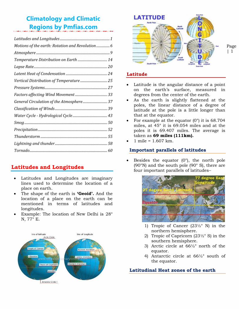
• Latitudes and Longitudes are imaginary lines used to determine the location of a place on earth.
• The shape of the earth is ‘Geoid’. And the location of a place on the earth can be mentioned in terms of latitudes and longitudes.
• Example: The location of New Delhi is 28° N, 77° E.
Latitude
• Latitude is the angular distance of a point on the earth’s surface, measured in degrees from the center of the earth.
• As the earth is slightly flattened at the poles, the linear distance of a degree of latitude at the pole is a little longer than that at the equator.
• For example at the equator (0°) it is 68.704 miles, at 45° it is 69.054 miles and at the poles it is 69.407 miles. The average is taken as 69 miles (111km).
• 1 mile = 1.607 km.
Important parallels of latitudes
• Besides the equator (0°), the north pole (90°N) and the south pole (90° S), there are four important parallels of latitudes–
1) Tropic of Cancer (23½° N) in the
northern hemisphere. 2) Tropic of Capricorn (23½° S) in the
southern hemisphere. 3) Arctic circle at 66½° north of the
equator. 4) Antarctic circle at 66½° south of
the equator.
Latitudinal Heat zones of the earth

Page | 8
Revolution
• The second motion of the earth around the sun in its orbit is called revolution. It takes 365¼ days (one year) to revolve around the sun.
• Six hours saved every year are added to make one day (24 hours) over a span of four years. This surplus day is added to the month of February. Thus every fourth year, February is of 29 days instead of 28 days. Such a year with 366 days is called a leap year.
Solstice
• On 21st June, the northern hemisphere is tilted towards the sun. The rays of the sun fall directly on the Tropic of Cancer. As a result, these areas receive more heat.
• The areas near the poles receive less heat as the rays of the sun are slanting.
• The north pole is inclined towards the sun
and the places beyond the Arctic Circle experience continuous daylight for about six months.
• Since a large portion of the northern hemisphere is getting light from the sun, it is summer in the regions north of the equator. The longest day and the shortest night at these places occur on 21st June.
• At this time in the southern hemisphere all these conditions are reversed. It is winter season there. The nights are longer than
the days. This position of the earth is called the summer solstice.
• On 22nd December, the Tropic of Capricorn receives direct rays of the sun as the south pole tilts towards it. As the sun’s rays fall vertically at the Tropic of Capricorn (23½° s), a larger portion of the southern hemisphere gets light. Therefore, it is summer in the southern hemisphere
with longer days and shorter nights. The reverse happens in the northern hemisphere. This position of the earth is called the winter solstice.
Equinox
• On 21st March and September 23rd, direct rays of the sun fall on the equator. At this position, neither of the poles is tilted towards the sun; so, the whole earth experiences equal days and equal nights. This is called an equinox.

Page | 26
1. Long nights, so that the outgoing radiation is greater than the incoming radiation.
2. Clear skies, which allow unobstructed escape of radiation.
3. Calm and stable air, so that there is no vertical mixing at lower levels.
Types of Temperature Inversion
Temperature Inversion in
Intermontane Valley (Air Drainage Type of Inversion)
• Sometimes, the temperature in the lower layers of air increases instead of decreasing with elevation. This happens commonly along a sloping surface.
• Here, the surface radiates heat back to space rapidly and cools down at a faster rate than the upper layers. As a result the lower cold layers get condensed and become heavy.
• The sloping surface underneath makes them move towards the bottom where the cold layer settles down as a zone of low temperature while the upper layers are relatively warmer.
• This condition, opposite to normal vertical distribution of temperature, is known as Temperature Inversion.
• In other words, the vertical temperature gets inverted during temperature inversion.
• This kind of temperature inversion is very strong in the middle and higher latitudes. It can be strong in regions with high mountains or deep valleys also.
Ground Inversion (Surface Temperature Inversion)
• A ground inversion develops when air is cooled by contact with a colder surface until it becomes cooler than the overlying atmosphere; this occurs most often on clear nights, when the ground cools off rapidly by radiation. If the temperature of surface air drops below its dew point, fog may result.
• This kind of temperature inversion is very common in the higher latitudes.
• Surface temperature inversion in lower and middle latitudes occurs during cold nights and gets destroyed during daytime.

Page | 30
• After saturation (complete loss of moisture) at the ITCZ, the air moving away from equatorial low pressure belt in the upper troposphere becomes dry and cold.
• This dry and cold wind subsides at 30°N and S.
• So the high pressure along this belt is due to subsidence of air coming from the equatorial region which descends after becoming heavy.
• The high pressure is also due to the blocking effect of air at upper levels because of the Coriolis force.
Climate
• The subsiding air is warm and dry, therefore, most of the deserts are present along this belt, in both hemispheres.
• A calm condition (anticyclonic) with feeble winds is created in this high pressure belt.
• The descending air currents feed the winds blowing towards adjoining low pressure belts.
• This belt is frequently invaded by tropical
and extra-tropical disturbances.
Horse Latitudes
• The corresponding latitudes of sub-tropical
high pressure belt are called horse latitudes.
• In early days, the sailing vessels with cargo of horses found it difficult to sail under calm conditions of this high pressure belt.
• They used to throw horses into the sea when fodder ran out. Hence the name horse latitudes.
Question mains 2013: Major hot deserts in northern hemisphere are
located between 20-30 degree north and on the western side of the continents. Why?

Page | 53
drops of rain after being released by the clouds become solidified into small rounded solid pieces of ice and which reach the surface of the earth are called hailstones. These are formed by the rainwater passing through the colder layers. Hailstones have several concentric layers of ice one over the other.
• Rainfall: drop size more than 0.5 mm
• Virage: raindrops evaporate before reaching the earth
• Drizzle: light rainfall; drop size less than 0.5 mm
• Mist: evaporation occurs before reaching the ground leading to foggy weather
• Snowfall: fine flakes of snow fall when the
temperature is less than 0°C
• Sleet: frozen raindrops and refrozen melted snow; mixture of snow and rain or merely partially melted snow
• Hail: precipitation in the form of hard rounded pellets is known as hail; 5 mm and 50 mm
Types of Rainfall
• On the basis of origin, rainfall may be classified into three main types – the convectional, orographic or relief and the cyclonic or frontal.
Conventional Rainfall
• The, air on being heated, becomes light and rises up in convection currents. As it rises, it expands and loses heat and consequently, condensation takes place and cumulous clouds are formed. This process releases latent heat of condensation which further heats the air and forces the air to go further up.
• Convectional precipitation is heavy but of short duration, highly localised and is associated with minimum amount of cloudiness. It occurs mainly during
summer and is common over equatorial doldrums in the Congo basin, the Amazon basin and the islands of south-east Asia.
Orographic Rainfall
• When the saturated air mass comes across a mountain, it is forced to ascend and as it rises, it expands (because of fall in pressure); the temperature falls, and the moisture is condensed.
• This type of precipitation occurs when warm, humid air strikes an orographic
barrier (a mountain range) head on. Because of the initial momentum, the air is forced to rise. As the moisture laden air gains height, condensation sets in, and soon saturation is reached. The surplus moisture falls down as orographic precipitation along the windward slopes.
• The chief characteristic of this sort of rain is that the windward slopes receive greater rainfall. After giving rain on the windward side, when these winds reach the other slope, they descend, and their temperature rises. Then their capacity to take in

Page
| 1
Oceanography by Pmfias.com
Oceanography by Pmfias.com................................................... 1
Ocean Relief ....................................................................................... 1
Marginal Seas ................................................................................... 5
Bays, gulfs, and Straits ................................................................. 8
The Pacific Ocean ........................................................................... 9
The Atlantic Ocean ...................................................................... 10
The Indian Ocean ......................................................................... 11
Ocean currents .............................................................................. 12
Temperature Distribution of Oceans .................................. 17
Pacific Ocean Currents .............................................................. 21
Atlantic Ocean Currents ........................................................... 24
Sargasso Sea .................................................................................. 25
Indian Ocean Currents .............................................................. 26
Ocean Salinity ................................................................................ 27
Tides ................................................................................................... 29
Types of Tides ................................................................................ 31
Coral Reefs ...................................................................................... 35
Ideal Conditions for Coral Growth ....................................... 37
Resources from the Ocean ....................................................... 40
Jurisdiction over the Seas ......................................................... 44
Sea Level Change ......................................................................... 46
Ocean Relief
Ocean relief is largely due to tectonic, volcanic, erosional and depositional processes and their interactions.
Ocean relief features are divided into major and minor relief features.
Major Ocean Relief Features
Four major divisions in the ocean relief are:
1. the continental shelf, 2. the continental slope, 3. the continental rise, 4. the Deep Sea Plain or the abyssal plain.
Minor Ocean Relief Features
Ridges,
Hills,
Seamounts,
Guyots,
Trenches,
Canyons,
Sleeps,
Fracture zones,
Island arcs,
Atolls,
Coral reefs,
Submerged volcanoes and
Sea-scarps.
Continental Shelf
Continental Shelf is the gently sloping seaward extension of continental plate.
These extended margins of each continent are occupied by relatively shallow seas and gulfs.
Continental Shelf of all oceans together cover 7.5% of the total area of the oceans.
Gradient of continental is of 1° or even less.
The shelf typically ends at a very steep slope, called the shelf break.

Page
| 2
The continental shelves are covered with variable thicknesses of sediments brought down by rivers, glaciers etc..
Massive sedimentary deposits received over a long time by the continental shelves, become the source of fossil fuels [Petroleum].
Examples: Continental Shelf of South-East Asia, Great Banks around Newfoundland,
Submerged region between Australia and New Guinea.
The shelf is formed mainly due to 1. submergence of a part of a continent 2. relative rise in sea level 3. Sedimentary deposits brought down
by rivers
There are various types of shelves based on different sediments of terrestrial origin —
1. glaciated shelf (Surrounding Greenland), 2. coral reef shelf (Queensland, Australia), 3. shelf of a large river (Around Nile Delta), 4. shelf with dendritic valleys (At the
Mouth of Hudson River) 5. shelf along young mountain ranges
(Shelves between Hawaiian Islands).
Width
The average width of continental shelves is between 70 – 80 km.
The shelves are almost absent or very narrow along some of the margins like the coasts of Chile, the west coast of Sumatra, etc. [Ocean – Continent Convergence and Ocean – Ocean Convergence].
It is up to 120 km wide along the eastern coast of USA. On the contrary, the Siberian shelf in the Arctic Ocean, the largest in the world, stretches to 1,500 km in width.
Depth

Page
| 15
the western shores and the cold currents along the eastern shores.
Convergence: warm and cold currents meet.
Divergence: a single current splits into multiple currents flowing in different directions.
The shape and position of coasts play an important role in guiding the direction of currents.
The currents flow not only at the surface but also below the sea surface (due to salinity and temperature difference).
For instance, heavy surface water of the Mediterranean Sea sinks and flows westward past Gibraltar as a sub-surface current.
Effects of Ocean Currents
Ocean currents have a number of direct and indirect influences on human activities.
Desert formation
Cold ocean currents have a direct effect on desert formation in west coast regions of the tropical and subtropical continents.
There is fog and most of the areas are arid due to desiccating effect (loss of moisture).
Rains
Warm ocean currents bring rain to coastal areas and even interiors. Example: Summer Rainfall in British Type climate.
Warm currents flow parallel to the east coasts of the continents in tropical and subtropical latitudes. This results in warm and rainy climates. These areas lie in the western margins of the subtropical anti-cyclones.
Moderating effect
They are responsible for moderate temperatures at coasts. [North Atlantic Drift brings warmness to England. Canary cold current brings cooling effect to Spain, Portugal etc.]
Fishing
Mixing of cold and warm ocean currents bear richest fishing grounds in the world.
Example: Grand Banks around Newfoundland, Canada and North-Eastern Coast of Japan.
The mixing of warm and cold currents help to replenish the oxygen and favor the growth of planktons, the primary food for fish population. The best fishing grounds

Page
| 26
Indian Ocean Currents
Indian ocean is half an ocean, hence the behavior of the North Indian Ocean Currents is different from that of Atlantic Ocean Currents or the Pacific Ocean Currents.
Also, monsoon winds in Northern Indian ocean are peculiar to the region, which directly influence the ocean surface water movement [North Indian Ocean Currents].
Indian Ocean Currents and Monsoons
The currents in the northern portion of the Indian Ocean change their direction from season to season in response to the seasonal rhythm of the monsoons. The effect of winds is comparatively more pronounced in the Indian Ocean.
Winter Circulation
Under the influence of prevailing trade winds [easterly trade winds], the north equatorial current and the south equatorial current start from the south of Indonesian islands, moving from east to west.
This raises the level of western Indian (south-east of horn of Africa) ocean by few centimeters. And this creates a counter-equatorial current which flows between the north equatorial current and the south equatorial current in west-east direction.
The north-east monsoons drive the water along the coast of Bay of Bengal to circulate in an anti-clockwise direction.
Similarly, the water along the coast of
Arabian Sea also circulate in an anti-clockwise circulation.
Summer Circulation – North Equatorial Current Counter-Equatorial
Current are Absent
In summer, due to the effects of the strong south-west monsoon and the absence of the north-east trades, a strong current flows from west to east, which completely obliterates the north equatorial
current. Hence, there is no counter-
equatorial current as well.
Thus, the circulation of water in the northern part of the ocean is clockwise during this season.
Southern Indian Ocean Currents -
Agulhas current, Mozambique current,
West Australian current
The general pattern of circulation in southern part of the Indian Ocean is quite similar to that of southern Atlantic and

Page
| 30
Together, the gravitational pull and the centrifugal force are responsible for creating the two major tidal bulges on the earth.
On the side of the earth facing the moon, a tidal bulge occurs while on the opposite side though the gravitational attraction of the moon is less as it is farther away, the centrifugal force causes tidal bulge on the other side.
The ‘tide-generating’ force is the difference between these two forces; i.e. the gravitational attraction of the moon and the centrifugal force.
On the surface of the earth, nearest the moon, pull or the attractive force of the moon is greater than the centrifugal force, and so there is a net force causing a bulge towards the moon.
On the opposite side of the earth, the attractive force is less, as it is farther away from the moon, the centrifugal force is dominant. Hence, there is a net force away from the moon. It creates the second bulge away from the moon.
Factors Controlling the Nature and
Magnitude of Tides
The movement of the moon in relation to the earth.
Changes in position of the sun and moon in relation to the earth.
Uneven distribution of water over the globe.
Irregularities in the configuration of the oceans.
https://www.youtube.com/watch?v=CTQ6ciHENgI
On the surface of the earth, the horizontal tide generating forces are more important than the vertical forces in generating the tidal bulges.
The tidal bulges on wide continental shelves, have greater height. When tidal
bulges hit the mid-oceanic islands they become low.
The shape of bays and estuaries along a coastline can also magnify the intensity of tides.
Funnel-shaped bays greatly change tidal magnitudes. When the tide is channeled between islands or into bays and estuaries they are called tidal currents (tidal bore is one such tidal current).
Tides of Bay of Fundy, Canada

Page | 1
Indian Geography by Pmfias.com
India As A Geographical Unit .................................................... 1
Rock System Based on Geological History Of India ........ 3
Major Physical Divisions of India ............................................ 6
Himalayan Ranges ......................................................................... 7
Major Passes in India and Indian Sub-continent .......... 17
Indo – Gangetic – Brahmaputra Plain ............................... 20
Peninsular Plateau ...................................................................... 25
Hill Ranges of the Peninsular Plateau ............................... 29
Coastline of India – Indian Coastline .................................. 32
Indian Islands ................................................................................ 35
Drainage patterns ....................................................................... 37
Indus River System ...................................................................... 45
Ganga River System .................................................................... 49
Brahmaputra River System .................................................... 53
Peninsular River System or Peninsular Drainage ........ 54
East Flowing Peninsular Rivers ............................................ 56
West Flowing Rivers of The Peninsular India ................ 65
Indian Monsoons .......................................................................... 73
Indian Climate ............................................................................... 90
Natural Vegetation of India.................................................. 111
Soil .................................................................................................... 117
Major Soil Groups of India ..................................................... 121
Soil Degradation ........................................................................ 127
Soil Conservation ....................................................................... 133
India As A Geographical Unit
East-West Extent of Main Land India (Including Pak occupied Kashmir-POK):
68° 7' east to 97° 25' east longitude
South-North Extent of Main Land India:
8° 4' north to 37° 6' north latitude
Locational Extent: 8° 4' N to 37° 6' N latitude and 68° 7' E to 97° 25' East longitude.
The southernmost point of the country is the Pygmalion Point or Indira Point is located at 6° 45' N latitude.
North-south extent from Indira Col in Kashmir to Kanniyakumari is 3,214 km.
East-west width from the Rann of Kachachh to Arunachal Pradesh is 2,933 km.
With an area of 32,87,263 sq km, India is the seventh largest country of the world.
India accounts for about 2.4 per cent of the total surface area of the world.

Page | 26
It is the plateau of eastern Rajasthan. [Marwar plain is to the west of Aravalis whereas Marwar plateau is to the east].
The average elevation is 250-500 m above sea level and it slopes down eastwards.
It is made up of sandstone, shales and limestones of the Vindhayan period.
The Banas river, along with its tributaries [Berach river, Khari rivers] originate in
the Aravali Range and flow towards northwest into Chambal river. The erosional activity of these rives make the plateau top appear like a rolling plain.
[Rolling Plain: ‘Rolling plains’ are not completely flat: there are slight rises and fall in the land form. Ex: Prairies of USA]
Central Highland

Page | 37
At present these islands are collectively known as Lakshadweep.
The Lakshadweep Islands are a group of 25 small islands.
They are widely scattered about 200-500 km south-west of the Kerala coast.
Amendivi Islands are the northern most while the Minicoy island is the southernmost.
All are tiny islands of coral origin {Atoll} and are surrounded by fringing reefs.
The largest and the most advanced is the Minicoy island with an area of 4.53 sq km.
Most of the islands have low elevation and do not rise more than five metre above sea
level (Extremely Vulnerable to sea level change).
Their topography is flat and relief features such as hills, streams, valleys, etc. are absent.
New Moore Island
It is a small uninhabited offshore sandbar landform {Marine Landforms} in the Bay of Bengal, off the coast of the Ganges-Brahmaputra Delta region.
It emerged in the Bay of Bengal in the aftermath of the Bhola cyclone in 1970. It keeps on emerging and disappearing.
Although the island was uninhabited and there were no permanent settlements or stations located on it, both India and Bangladesh claimed sovereignty over it because of speculation over the existence of oil and natural gas in the region.
The issue of sovereignty was also a part of the larger dispute over the Radcliffe Award methodology of settling the maritime boundary between the two nations
Drainage patterns
Based on the shape and formation of river patters, there are different drainage patterns.
Basics
Drainage basin
Other terms that are used to describe drainage basins are catchment, catchment area, catchment basin, drainage area, river
basin, and water basin. The drainage basin includes both the
streams and rivers and the land surface.
The drainage basin acts as a funnel by
collecting all the water within the area covered by the basin and channeling it to a
single point.
In closed ("endorheic") drainage basins the water converges to a single point inside the basin, known as a sink, which may be a permanent lake [Lake Aral], dry lake [some desert lakes], or a point where surface water is lost underground [sink holes in Karst landforms]. Other Examples: Lake Chad [Africa], Dead Sea etc.
Drainage Divide

Page | 48
Chenab River
The Chenab originates from near the Bara Lacha Pass in the Lahul-Spiti part of the Zaskar Range.
Two small streams on opposite sides of the pass, namely Chandra and Bhaga, form its headwaters at an altitude of 4,900 m.
The united stream Chandrabhaga flows in the north-west direction through the Pangi valley, parallel to the Pir Panjal range.
Near Kistwar, it cuts a deep gorge.
It enters the plain area near Akhnur in Jammu and Kashmir.
From here it through the plains of Pakistani Punjab to reach Panchnad where it joins the Satluj after receiving the waters of Jhelum and Ravi rivers.
Ravi River
The Ravi has its source in Kullu hills near the Rohtang Pass in Himachal Pradesh.
It drains the area between the Pir Panjal and the Dhaola Dhar ranges.
After crossing Chamba, it takes a south-westerly turn and cuts a deep gorge in the Dhaola Dhar range.
It enters Punjab Plains near Madhopur and later enters Pakistan below Amritsar.
It debouches into the Chenab a little above Rangpur in Pakistani Punjab.
Beas River
The Beas originates near the Rohtang Pass, at a height of 4,062 m above sea level, on the southern end of the Pir Panjal Range, close to the source of the Ravi.
It crosses the Dhaola Dhar range and it takes a south-westerly direction and meets the Satluj river at Harike in Punjab.
It is a comparatively small river which is only 460 km long but lies entirely within the Indian territory.
Satluj River
The Satluj rises from the Manasarovar-Rakas Lakes in western Tibet at a height of 4,570 m within 80 km of the source of the Indus.
Like the Indus, it takes a north-westerly
course upto the Shipki La on the Tibet-
Himachal Pradesh boundary.
It cuts deep gorges where it pierces the Great Himalaya and the other Himalayan ranges.
Before entering the Punjab plain, it cuts a gorge in Naina Devi Dhar, where the famous Bhakra dam has been constructed.
After entering the plain at Rupnagar (Ropar), it turns westwards and is joined by the Beas at Harike.

Page | 75
Indian Monsoons – Classical Theory: Sir
Edmund Halley’s Theory
Summer Monsoon
In summer the sun’s apparent path is vertically over the Tropic of Cancer resulting in high temperature and low pressure in Central Asia.
The pressure is sufficiently high over Arabian Sea and Bay of Bengal. Hence winds flowed from Oceans flow towards landmass in summer.
This air flow from sea to land bring heavy rainfall to the Indian subcontinent.
Winter Monsoon
In winter the sun’s apparent path is vertically over the Tropic of Capricorn.
The north western part of India grows colder than Arabian Sea and Bay of Bengal and the flow of the monsoon is reversed.
The basic idea behind Classical theory is similar to land and sea breeze formation except that in the case of monsoons the day and night are replaced by summer and winter.
Drawbacks: The monsoons do not develop equally everywhere on earth and the thermal concept of Halley fails to explain the intricacies of the monsoons such as the sudden burst of monsoons, delay in on set of monsoons sometimes, etc..
Indian Monsoons – Modern theory: Air
Mass Theory
According to this theory, the monsoon is simply a modification of the planetary winds of the tropics.
The theory is based on the migration of ITCZ based on seasons.
Indian Monsoons – Role of ITCZ [Inter-
Tropical Convergence Zone]
The southeast trade winds in the southern hemisphere and the northeast trade winds in the northern hemisphere meet each other near the equator.
The meeting place of these winds is known as the Inter-Tropical Convergence Zone (ITCZ).
This is the region of ascending air, maximum clouds and heavy rainfall.
The location of ITCZ shifts north and south of equator with the change of season.

Page | 83

Page | 121
In cold climates of the Himalayan region, the process of vegetation decay is very slow and the soils are acidic in nature.
In areas of heavy rainfall and high temperature, the soils are red or lateritic. Why?
Torrential rainfall during the rainy season washes the upper soil and leaches the materials into deeper horizon.
During the dry summer season the evaporation exceeds precipitation and through capillary action iron and aluminium oxides are transported to the surface making the soil red.
In areas of alternate wet and dry climate, the leached material which goes deep down in the horizon is brought up and the
blazing sun bakes the top soil so hard that it resembles a brick. Therefore, this soil is called lateritic which literally means
brick.
Natural Vegetation
Natural vegetation reflects the combined effects of relief and climate.
The formation and development of soil is very much influenced by the growth of vegetation.
The decayed leaf material adds much needed humus to soil thereby increasing its fertility.
The densely forested areas contain some of the best soils in India. There is a close
relationship between the vegetation types and soil types in India.
Major Soil Groups of India

Page | 1
Economic Geography by
Pmfias.com
Iron Ore ............................................................................................... 1
Iron Ore Distribution Across the World ............................... 4
Iron Ore Distribution in India ................................................... 5
Coal ....................................................................................................... 6
Distribution of Coal in India ...................................................... 8
Distribution of Coal across the World ................................ 15
Petroleum and Mineral Oil ...................................................... 16
Natural gas ..................................................................................... 24
Unconventional Gas Reservoirs ............................................. 28
Bauxite .............................................................................................. 32
Lead and Zinc ................................................................................ 33
Tungsten .......................................................................................... 34
Pyrites ............................................................................................... 34
Gold Reserves in India ............................................................... 34
Gold Distribution Across the World .................................... 35
Silver Distribution – India & World .................................... 35
Manganese ...................................................................................... 36
Chromite .......................................................................................... 37
Copper ............................................................................................... 38
Nickel ................................................................................................. 39
Graphite ........................................................................................... 40
Diamonds......................................................................................... 41
Non-Metallic Minerals ............................................................... 43
Nuclear fission............................................................................... 46
Types of Nuclear Reactors ....................................................... 49
Atomic Minerals ........................................................................... 53
India's Three-Stage Nuclear Power Programme .......... 57
Iron Ore
The below data is important for Prelims [Will be helpful to answer some logic based questions in mains]
To understand about the factors that influence the location of Iron and Steel Industry, we have to understand about iron ore smelting.
Smelting is a process of converting ore to metal by removing impurities.
Commonly found impurities in Iron Ore
Silicon
Found in small quantities.
Slightly raises the Strength and Hardness of Steel.
Acts as a de-oxidizing Agent ==> small quantities is good. [Oxides decrease the strength of Iron]
Sulphur
A VERY harmful element.
Forms Iron Sulphide which is a very brittle substance.
Greatly reducing the Strength of Steel ==> very bad.
Phosphorous
Combines with Iron to form a Phosphide.
It increases the hardness and Tensile strength of Steel.
It SERIOUSLY affects the ductility and resistance to shock or impact ==> bad.
Lead
Added to all classes of Steel to improve the machinability of the Steel.
It improves tool life ==> small quantities is good.
Manganese
A powerful and most effective de-oxidant.
Has a good effect on Sulphur ==> small quantities is good.
Tin
It forms a low melting point brittle film round the grain boundaries making the Steel practically useless ==> very bad.
Oxygen
Has a bad influence on the properties of steel ==> very bad. [Oxides make Iron and steel weak]
Of the impurities, some are beneficial when present in small quantities while the others are harmful no matter what their proportion is.

Page | 4
Government policy – Development agenda, land acquisition, ease of doing business = labor laws, unambiguous and fair taxation policy, least government interference, less red tapeism, quick environmental clearance.
This notes covers only Mineral Distribution. Read mrunal.org/geography for Industrial Locational Factors].
Iron Ore Distribution Across the
World
Iron Ore in China – Manchuria,
Sinkiang, Si-kiang, Shandog Peninsula
Iron Ore in Europe – Ruhr, South
Whales, Krivoy Rog, Bilbao, Lorraine
Iron Ore in South America – Carajas,
Itabira, Minas Geriais
Iron ore in Africa – Transvaal, Liberia
Iron ore in Russia, Kazakhstan – Ural
region, Magnitogorsk
Iron Ore in North America – Great
Lakes [Mesabi Region], Labrador
Iron Ore in Australia – Pilbara Region,
Koolyanobbing, Iron Duke, Iron Knob
Page | 7
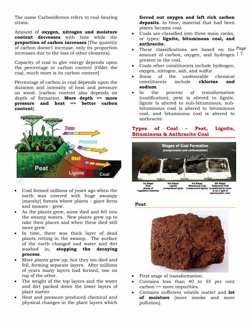
The name Carboniferous refers to coal-bearing strata.
Amount of oxygen, nitrogen and moisture content decreases with time while the proportion of carbon increases [The quantity of carbon doesn’t increase, only its proportion increases due to the loss of other elements].
Capacity of coal to give energy depends upon the percentage or carbon content [Older the coal, much more is its carbon content].
Percentage of carbon in coal depends upon the duration and intensity of heat and pressure on wood. [carbon content also depends on depth of formation. More depth == more pressure and heat == better carbon content].
Coal formed millions of years ago when the earth was covered with huge swampy [marshy] forests where plants - giant ferns and mosses - grew.
As the plants grew, some died and fell into the swamp waters. New plants grew up to take their places and when these died still more grew.
In time, there was thick layer of dead plants rotting in the swamp. The surface of the earth changed and water and dirt washed in, stopping the decaying process.
More plants grew up, but they too died and fell, forming separate layers. After millions of years many layers had formed, one on top of the other.
The weight of the top layers and the water and dirt packed down the lower layers of plant matter.
Heat and pressure produced chemical and physical changes in the plant layers which
forced out oxygen and left rich carbon deposits. In time, material that had been plants became coal.
Coals are classified into three main ranks, or types: lignite, bituminous coal, and anthracite.
These classifications are based on the amount of carbon, oxygen, and hydrogen present in the coal.
Coals other constituents include hydrogen, oxygen, nitrogen, ash, and sulfur.
Some of the undesirable chemical constituents include chlorine and sodium.
In the process of transformation (coalification), peat is altered to lignite, lignite is altered to sub-bituminous, sub-bituminous coal is altered to bituminous coal, and bituminous coal is altered to anthracite.
Types of Coal – Peat, Lignite,
Bituminous & Anthracite Coal
Peat
First stage of transformation.
Contains less than 40 to 55 per cent carbon == more impurities.
Contains sufficient volatile matter and lot of moisture [more smoke and more pollution].

Page | 28
Storage facilities are essential for safeguard against shortages or supply disruptions.
Downstream sector
This sector involves refining, processing and marketing of products and byproducts of crude oil.
Unconventional Gas Reservoirs
Conventional reservoirs of oil and natural gas are found in permeable sandstone.
Unconventional Gas Reservoirs occur in relatively impermeable sandstones, in joints and fractures or absorbed into the matrix of shales [Shale is a Sedimentary Rock], and in coal seams.
Given current economic conditions and state of technology, they are more expensive to exploit.
Example: Tight gas, shale gas, and coal-bed methane.
Coalbed Methane
Considerable quantities of methane is trapped within coal seams.
A significant portion of this gas remains as free gas in the joints and fractures of the coal seam.
Large quantities of gas are adsorbed on the internal surfaces of the micropores within the coal itself.
This gas can be accessed by drilling wells into the coal seam and pumping large quantities of water that saturate the seam. [water will occupy the gaps and pores and will push out the gas]
It is now becoming an important source of natural gas.
Unlike much natural gas from conventional reservoirs, coalbed methane contains very little heavier hydrocarbons such as propane or butane.
The presence of this gas is well known from its occurrence in underground coal mining, where it presents a serious safety risk.
Fire Accidents in Coal Mines are mainly due to Coalbed Methane, and Lignite deposits which undergo spontaneous combustion.
Coalbed Methane in India
With one of the largest proven coal reserves, and one of the largest coal producer in the world, India holds significant prospects for commercial recovery of coalbed methane.
The country has an estimated 700-950 billion cubic metre of coalbed methane.
Problems in Exploration, Extraction of
Coalbed Methane in India
The state-run firms are holding mines in joint venture with private companies and the latter do not have rights to explore coalbed methane [private sector companies at present have no rights to extract unconventional gas reservoirs –– coalbed methane and shale gas].
CBM extraction falls under Ministry of Petroleum & Natural Gas whereas coal mining falls under Ministry of Coal. Contractors are not allowed to mine gas from coal seams or coal bed methane (CBM) and coal in the same block due to the turf war [common feature of Indian Bureaucracy] between the two ministries and other associated bureaucratic hurdles.
Extracting unconventional gas is a capital intensive process and at the present levels

Page | 43
force. This gives graphite it’s very low hardness, its perfect cleavage and its slippery feel.
[Pencil Lead is not made of lead as we normally beleive. It is made of graphite. You know why?]
make diamond an exceptionally hard material.
Non-Metallic Minerals
Mica
Mica is a naturally occurring non-metallic mineral that is based on a collection of silicates.
Mica is a very good insulator that has a wide range of applications in electrical and electronics industry.
It can withstand high voltage and has low power loss factor.
It is used in toothpaste and cosmetics
because of its glittery appearance. It also acts as a mild abrasive in toothpaste.
India is one of the foremost suppliers of mica to the world. Mica-bearing igneous rocks occur in AP, Bihar, Jharkhand, Maharashtra, Rajasthan.
Mica Reserves in India
1. Andhra Pradesh (41 per cent) 2. Rajasthan (21 per cent) 3. Odisha (20 per cent) 4. Maharashtra (15 per cent)
5. Bihar (2 per cent) 6. Jharkhand (Less than 1 per cent)
Mica Distribution and Production in
India
India has a near monopoly in the production of mica [60 % of world's total].
Production decreased in recent times due to fall in demand in the international market. Fall in demand is due to better synthetic alternatives that are available.
Andhra Pradesh
1st in production [93 %].
The mica belt lies in Nellore district [Gudur Mica mines].
Vishakhapatnam, West Godavari and Krishna are other important mica producing districts.
Rajasthan
2nd in production [6.3 %].
The main mica belt extends from Jaipur to Udaipur [Along Aravalis].
Jharkhand
3rd in production.
Mica is found in a belt extending for about 150 km in length and 32 km in width from Gaya district of Bihar to Hazaribagh and Koderma districts of Jharkhand. This belt contains the richest deposits of high quality ruby mica.
Koderma is a well-known place for mica production in Jharkhand.
Mica Exports
India is the largest exporter of mica.
Certain grades of Indian mica are and will remain vital to the world's electrical industries.
Major exports are carried out through Kolkata and Vishakhapatnam ports.
Important imports of Indian mica are Japan (19%), the USA (17%), U.K, etc.