Embed Size (px)
Citation preview
312
Geoarchaeology and Archaeomineralogy (Eds. R. I. Kostov, B. Gaydarska, M. Gurova). 2008. Proceedings of the International Conference, 29-30 October 2008 Sofia, Publishing House “St. Ivan Rilski”, Sofia, 312-314.
GEOMORPHOLOGICAL SURVEY OF THE AREA OF ARCHAEOLOGICAL SITE BOSILKOVO (BANITE MUNICIPALITY), SOUTH BULGARIA Rossitsa Kenderova
University of Sofia “St. Kliment Ohridski”, 15 Tzar Osvoboditel Blvd., 1504 Sofia; [email protected]
ABSTRACT. The results from geomorphological study of the archaeological site Bosilkovo, situated in the Prespa Ridge, Middle Rhodopes are resented. The function of the site was as a sanctuary and it was active from the Chalcolithic to the Iron Age. One profile and specific sediment materials were described and sampled in order to specify their origin. Morphoscopic analysis of the pebble and full granulometric analysis of all the horizons have been made. Attention is paid to the colour of the soil, referring to the differences in the anthropogenically influenced deposits and the lowest horizons of the weathering curst.
Geological and geomorphological setting The archaeological site is defined as prehistoric sanctuary. Several banks situated at different places are observed that have different height and state of preservation. The highest bank has average height of 1.5 m and it surrounds the North site of the peak. It has West-East orientation. At the highest part of the peak are situated two more banks, which look like hills (they have a 5-3 and 3-2 m height). The date of the site is according to the pottery data. The largest quantity of pottery is from the Late Chalcolithic, followed by sherds from the Late Bronze Age (up to 1300 BC) and there are several fragments from the Iron Age. It is remarkable that the Chalcolithic is on the surface of the outward bank. On the North slope the bank lies on a layer from the Late Chalcolithic. Moreover, there are rounded and not rounded ceramic pieces observed. The sanctuary is situated on a relict hill. It is defined as slope bornhardt, situated at the right site of Gloginsko Dere River, which is a left tributary of the Davidkovska Arda River. According to the geomorphological setting (Kanev, 1981; Geography of Bulgaria, 1997), this area is part of the West Rhodopes and the Prespa Ridge (with highest peak Prespa, 2000 m). Referring to some new ideas (Baltakov, 2003) this territory belongs to the Middle Rhodopes. They are separated from the Western Rhodopes by the gorge of Vatcha River to Gorna Arda. According to petrography the area is built of Gneiss-migmatite complex of Precambrian age, present by migmatites and migmatized double mica gneisses. Because of their
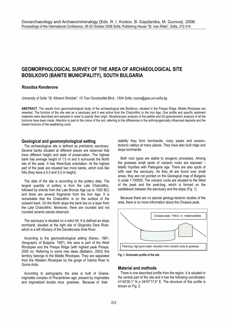
stability they form bornhardts, rocky peaks and erosion-tectonic valleys at many places. They have also built ridge and slope bornhardts. Both rock types are stable to exogenic processes. Among the gneisses small spots of volcanic rocks are exposed – felsitic rhyolites with Paleogene age. There are also spots of tuffs near the sanctuary. As they all are found over small areas, they are not pointed on the Geological map of Bulgaria in scale 1:100000. The volcanic rocks are situated to the West of the peak and the peat-bog, which is formed on the saddleback between the sanctuary and the slope (Fig. 1). Because there are no special geology-tectonic studies of the area, there is no more information about the Chukara peak.
Fig. 1. Schematic profile of the site
Material and methods There is one described profile from the region. It is situated in the central part of the site and it has the following coordinates: 41о42’00,1” N и 24о57’17,9” E. The structure of this profile is shown on Fig. 2.
Peat-bog, high grunt water, transition from volcanic rocks to gneisses
Chukara peak, 1184,6 m; metamorphites
313
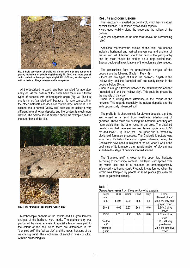
Fig. 2. Field description of profile М1: 0-5 cm; soil; 5-30 cm; humus with gravel; inclusions of pebble, clayish-sandy fill; 30-42 cm; more grayish and clayish than the upper layer; clayish fill; 42-55 cm; weathering curst with inclusions of large non-rounded brown pieces
All the described horizons have been sampled for laboratory analyses. At the bottom of the outer bank there are different types of deposits with anthropogenic origin (Fig. 3). The first one is named “trampled soil”, because it is more compact than the other materials and does not contain large inclusions. The second one is named “yellow soil” because the colour is very different from all other deposits and the content is much more clayish. The “yellow soil” is situated above the “trampled soil” in the outer bank of the site.
Fig. 3. The “trampled” soil and the “yellow clay”
Morphoscopic analysis of the pebble and full granulometric analysis of the horizons were made. The granulometry was performed by sieve analysis. A special attention was paid to the colour of the soil, since there are differences in the “trampled soil”, the “yellow clay” and the lowest horizons of the weathering curst. The mechanism of sampling was consulted with the archaeologists.
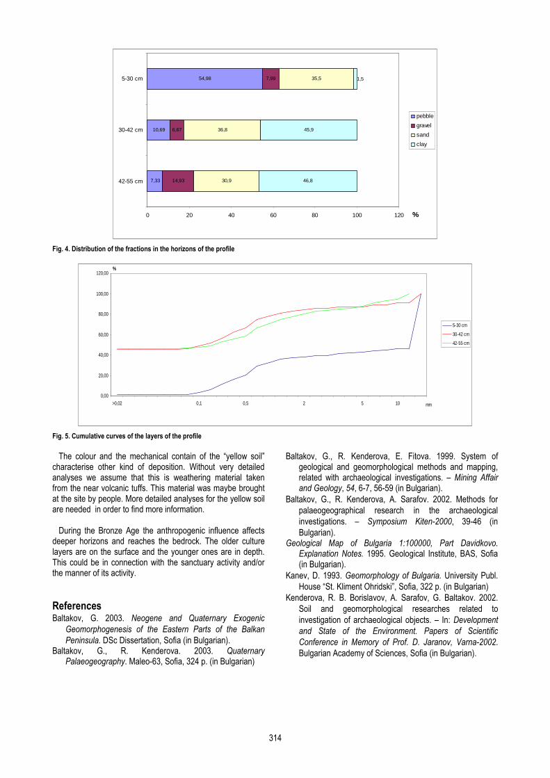
Results and conclusions The sanctuary is situated on bornhardt, which has a natural special situation. It is defined by two main aspects: ▪ very good visibility along the slope and the valleys at the bottom; ▪ very well separation of the bornhardt above the surrounding relief. Additional morphometric studies of the relief are needed including horizontal and vertical unevenness and analysis of the erosion set. Attention should be paid to the petrography and the rocks should be marked on a large scaled map. Special geological investigations of the region are also needed. The conclusions from the granulometric analysis of the deposits are the following (Table 1; Fig. 4-5): ▪ there are two types of fills in the horizons: clayish in the “yellow clay” and the “trampled soil” and sandy-clayish in the deposits below 30 cm; ▪ there is a huge difference between the natural layers and the “trampled soil” and the “yellow clay”. This could be proved by the quantity of the clay; ▪ there is a distinguished difference in the colour of the horizons. This regards especially the natural deposits and the anthropogenically influenced soil. The profile M1 is characteristic for eluvium deposits, e.g. they are formed as a result from weathering (destruction) of gneisses. These rocks are building the bornhardt and they are more stable than the other rocks in the area. The obtained results show that there are two main layers: upper – up to 30 cm and lower – up to 55 cm. The upper one is formed by eluvial-soil formation processes. The Chalcolithic pottery was found in it. Probably the anthropogenic influence during the Chalcolithic developed in this part of the soil when it was in the beginning of its formation, e.g. transformation of eluvium into soil when the stage of humification had started. The “trampled soil” is close to the upper two horizons according to mechanical content. This layer is not spread over the whole site and it is assumed as anthropogenically influenced weathering curst. Probably it was formed when the terrain was trampled by people at some places (for example paths or gathering places). Table 1 Generalized results from the granulometric analysis
Layer (cm)
Pebble Gravel Sand Clay Colour (Munsell charts)
5-30 54.98 7.99 35.5 1.5 2.5Y 3/2 very dark grayish brown
30-42 10.69 6.67 36.8 45.9 2.5Y 4/3 olive brown
42-55 7.33 14.93 30.9 46.8 2.5Y 4/4 olive brown
“Yellow soil”
10YR 7/4 very pale brown
“Trampling soil”
2.5Y 5/3 light olive brown
314
7,33
10,69
54,98
14,93
6,67
7,99
30,9
36,8
35,5
46,8
45,9
1,5
0 20 40 60 80 100 120
42-55 cm
30-42 cm
5-30 cm
%
pebble
gravel
sand
clay
Fig. 4. Distribution of the fractions in the horizons of the profile
0,00
20,00
40,00
60,00
80,00
100,00
120,00
>0,02 0,1 0,5 2 5 10 mm
%
5-30 cm
30-42 cm
42-55 cm
Fig. 5. Cumulative curves of the layers of the profile
The colour and the mechanical contain of the “yellow soil” characterise other kind of deposition. Without very detailed analyses we assume that this is weathering material taken from the near volcanic tuffs. This material was maybe brought at the site by people. More detailed analyses for the yellow soil are needed in order to find more information. During the Bronze Age the anthropogenic influence affects deeper horizons and reaches the bedrock. The older culture layers are on the surface and the younger ones are in depth. This could be in connection with the sanctuary activity and/or the manner of its activity.
References Baltakov, G. 2003. Neogene and Quaternary Exogenic
Geomorphogenesis of the Eastern Parts of the Balkan
Peninsula. DSc Dissertation, Sofia (in Bulgarian). Baltakov, G., R. Kenderova. 2003. Quaternary
Palaeogeography. Maleo-63, Sofia, 324 p. (in Bulgarian)
Baltakov, G., R. Kenderova, E. Fitova. 1999. System of
geological and geomorphological methods and mapping, related with archaeological investigations. – Mining Affair and Geology, 54, 6-7, 56-59 (in Bulgarian).
Baltakov, G., R. Kenderova, A. Sarafov. 2002. Methods for
palaeogeographical research in the archaeological
investigations. – Symposium Kiten-2000, 39-46 (in
Bulgarian). Geological Map of Bulgaria 1:100000, Part Davidkovo.
Explanation Notes. 1995. Geological Institute, BAS, Sofia (in Bulgarian).
Kanev, D. 1993. Geomorphology of Bulgaria. University Publ.
House “St. Kliment Ohridski”, Sofia, 322 p. (in Bulgarian)
Kenderova, R. B. Borislavov, A. Sarafov, G. Baltakov. 2002.
Soil and geomorphological researches related to
investigation of archaeological objects. – In: Development
and State of the Environment. Papers of Scientific
Conference in Memory of Prof. D. Jaranov, Varna-2002.
Bulgarian Academy of Sciences, Sofia (in Bulgarian).