Embed Size (px)
Citation preview
International Journal of Environment and Geoinformatics 3 (2), 11-23 (2016)
Geomorphic Regionalization of Coastal Zone Using Geospatial
Technology
Manoranjan Mishra1*
1 Gangadhar Meher University, Department of Geography, 768004, ORISSA-IN
Received 13 May 2016 Corresponding author*
E-mail: [email protected] Accepted 24 June 2016
Abstract
The world coastal environment is made of diversified landforms and are also potentially vulnerable to climate
variability, delta sinking, extreme events and anthropogenic interferences. Sustainable management of coastal
resources and transforming quality ecosystem services to future generation are the goals of Integrated Coastal
Zone Management (ICZM). Geographical homogenous unit are the basic implementation locus and back bone
of these kinds of integrated management strategy and activities. However, coastal zone management projects in
developing world using use arbitrary land-ward and sea-ward boundaries from physical reference as unit of
management. The oversimplified fixed distance approaches are not able to map the spatial and temporal
changes in coastal systems. The spatio-temporal variations of coastal systems are configured in geomorphic
landforms and further that work on interaction between natural forces and anthropogenic inputs. The present
research work is an attempt to present a simplified method of regionalization geomorphic landforms using
geospatial platforms for delineating Orissa coast into smaller homogenous geographic unit as reference point
for future management. Geomorphic landforms are reconstructed using Enhanced Thematic Mapper Plus
(ETM+) imagery, Survey of India topomaps, field survey and Digital Elevation Model data at geographic
information system (GIS) plat form. Seventy geomorphic features covering an area of 5033.64 km2 were
identified and further, regionalized into five homogenous geographic units. The need of time is to recognize
unsustainable coastal systems in these homogenous geographic units by fine tuning development parameters
and also same time allowing coastal systems to adapt naturally to any kind of variability. Although, the
methodology applied to Orissa for delineation homogenous geographic area but it can be replicated to any
coast in world.
Keywords: Coastal landforms, Geospatial technique, Geomorphic regionalization, Homogenous geographic
units & Integrated coastal zone management
Introduction
The coastal landscapes of the world are under
tremendous stresses from climate change,
environmental change, sea level changes,
population growth and developmental pressure.
These coastal stretch are approximately home
of 60 % of the population and also considered a
symbol of human develop and inequality
(UNEP, 2007; Yu et al., 2010 & Magarotto, et
al., 2014). The fragile coastal natural systems
are also highly dynamic in terms of diverse
ecosystems, complex geomorphic configuration
and a place for intensive anthropogenic
activities. Again, the collision between self-
regulated natural forces and constructed world
aggravate the sensitive coastal ecosystem to
high risk zone with characteristic spatial
heterogeneity, variability and uncertainty
(Kumar, et al., 2010 & Lin et al., 2013). Thus
managing the coastal zone under Integrated
Coastal Zone Management emphasized the role
of spatial information, coherent relational data
base management system for effective
sustainable regional development of the area
(Ya´n˜ ez-Arancibia & Day, 2004; Fresca,
2007). Majority coastal managers and decision
makers in developing countries are using this
term ‘coastal zone management’ as variety of
development programmes and mostly land use
plans with administrative boundary as the unit
of delineation (OECD, 1992; CCD, 1997 &
CRZ, 2011). However, integrated vision of
coastal zone is possible only by defining a clear
picture of spatial homogenous unit and also
managed on their specific characteristics and
11
M. Mishra / IJEGEO 3 (2), 11-23 (2016)
12
needs. The correct way to delineate these
geographical homogenous units is to map the
relational space between conflicting natural
forces and cultural landscapes. Thus,
regionalization of geomorphic landforms is
appropriate method for identifying these
homogenous units and also representation of
processes answering the complex problems
(Dramisa et al., 2011; Vannametee et al., 2012
& Embabi & Moaward, 2014).
Geomorphological mapping involves
categorizing the transitional space into
conceptual spatial units/entities based upon
morphology (form), genetics (process),
composition and structure, chronology,
environmental system associations (land cover,
soils, ecology), as well as spatial topological
relationships of surface features (landforms)
(Bishop, et al., 2012 & Embabi, 2014). Natural
regionalization of coastal geomorphic
landforms into geographical unit can be
backbone for future management strategy in
developing countries like India.
Recent advancement in geospatial technology,
numerical modeling and geocomputational
algorithms have revolutionized the field of
geomorphology and allowed geoscientists to go
beyond traditional mapping (Bishop et al.,
2012). The availability open source Landsat
Imagery and GIS software have allowed new
insight of rapid mapping of landforms in
developing countries that would otherwise
uneconomic and time consuming processes.
Advances in spatial and temporal resolution in
satellite imagery have helped to produced
spatio-temporal geomorphic mapping at
different scale used by coastal managers around
the world (Silva et al., 2007; Costa et al., 2008;
Henriques & Tenedorio, 2009 & James et al.,
2012). Majority of the coastal landforms are
delineated by onscreen digitization manually or
digital image processing by superimposing
DEM or google earth (Evans, 2012;
Seijmonsbergen, 2012). However, semi-
automated extraction methods are used now
days for geomorphological mapping (Qin et al.,
2009; Moawad and Khidr, 2011;
Seijmonsbergen et al., 2011; Bishop et al.,
2012; Evans, 2012; Seijmonsbergen, 2012;
Wilson, 2012). Thus, modern digital
geomorphological map consists layers of spatial
and non-spatial data base stored in GIS
platform which can be used for visualization,
analysis and thematic mapping.
With above background, this paper tries to
develop new method of delineating coastal zone
into smaller geographical unit that can provide
possible answer in managing theses vulnerable
ecosystems in a sustainable way. This study
introduces a methodology of geomorphic
regionalization i.e. classification of coastal zone
into homogenous geographical unit based on
geospatial technology. The study area chosen is
the most unexplored coast of Orissa, India. The
spatial homogenous units should be further
integrated with stronger conservation plans and
will be tool of Integrated Coastal Zone
Management (ICZM) of the state for achieve
sustainable regional development.
Study Area
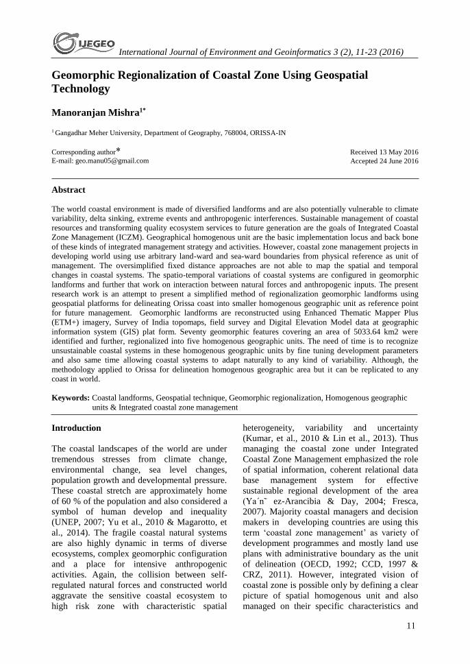
The chosen coastline for the study, Orissa is
located on the eastern coast of India and has a
coastline of 480 km with co-ordinates of 17°
48'N, 81°24´E to 22°34´N, 87°29´E including
immense natural resources (Fig. 1).
The coastal plain belong to post-Tertiary period
are combination of several deltas of varied size
and shapes (Sinha, 1971). Further, it is bulged
out in middle portion from Brahamagiri in
Chilika lake (SW) to Chandabali (NNE)
making convexity of the coast by three major
river Brahmani, Baitarni and Mahandi showing
recent delta formation. Again, the coastline is
dotted with bay bars, spit, hook made by
offshore long currents and estuaries in mouth of
major rivers. The study area attracts
international tourists and pilgrimage because it
is having a world heritage site. It is gifted with
Asia’s largest natural brackish water lagoon
(Chilika) and world’s largest known nesting
beach of Olive Ridley sea turtles (Gahirmatha
and Rusikulaya). The coast is impregnated with
one natural harbor Paradeep and number of
minor ports.
M. Mishra / IJEGEO 3 (2), 11-23 (2016)
13
Figure 1: Location of study area with administrative division of coastal Orissa
The study area having a tropical climate and
summer temperature ranges between 35°- 45°C
and seasonal low of 12°- 14°C. The monsoon
cyclones are directly responsible for high
annual rainfall measured above 140 cm. These
areas are also vulnerable to multiple disasters
like cyclonic storms, storm surge, high tide,
floods, delta sinking and sea level changes. The
threats to these kinds of extreme events have
increased many folds due to high population
growth and unplanned investments. Super
cyclone 1999 has caused massive damage and
destruction of life and property in Jagatsighpur
district. Loss of land to shoreline changes are a
common phenomenon in the study area.
Witnessing these changes in last two decades,
Government of Orissa started Integrated
Coastal Zone Management project sponsored
by World Bank to deal with these kind of crisis.
The present study is an attempt to naturally
regionalize coastal landforms in to smaller
geographical unit, which can facilitate the
district administration for developing stronger
conservation plan for future policy making
processes.
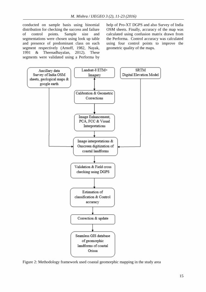
Materials and Methods
Advance geospatial platforms are ideal tools
not only for delineating coastal landforms but
also scan spatial and temporal variability
processes. The following data bases were used
for identification of geomorphic landforms and
also natural delineation of coastal geomorphic
landforms.
Survey of India OSM sheets having scale of
1:50,000 were scanned at 500 dpi using HP
Scan Jet 3300 C scanner and saved in Tagg
Image File Format (TIFF) before geo-
referencing. The ETM image and scanned
survey of India OSM sheets were rectified
using 300 – 400 ground control points taken
from field survey using Pro-XT DGPS. The
pixel coordinates of ETM images and OSM
sheets were substituted with GCP using affine
transformation representing the real world with
overall RMSE of less than 1 meter. All the geo-
referenced images were projected to UTM
system, WGS-84 and Zone 45 North and
clipped, stacked to match the boundary of entire
M. Mishra / IJEGEO 3 (2), 11-23 (2016)
14
area. On screen image interpretation techniques
were used for mapping coastal land forms in the
study area. Additionally, false colour composite
visual interpretation, principal component
analysis and image enhancement techniques
were applied to highlight the coastal
geomorphic feature (Mishra & Sharma, 2009;
Kumar et al., 2010; Kaliraj and Chandraseka,
2012 & Mishra, 2013,). False colour composite
were used for better visual representation of
micro features in the study area. A standard
FCC choose three original bands in red, green
and blue as RGB. However, it was found that
73 % of image variance in FCC but 97 %
variations was found in PCA than original
images. Therefore, algorithms of PCA were
correlated with two multispectral bands for
identifying potential geomorphic landforms
information. Further, first three PC images (PC
1, 2, 3) contains 98 % of variations of originals
six ETM bands representing significant
compression of the data. The other bands
showed only 2 % of original variations. The
first principal component contains maximum
information combined with PC2 image because
it shows better interpretation value. ETM
images were enhanced to visualize image
detection and also improve the geometric
details of the study area. Linear edge
enhancement techniques were applied to
delineate geomorphic landforms edge, shape by
using brightness of pixels of two adjacent
features. Images were interpreted using digital
image process and landforms were classified
and extracted.
Table 1. Source of databases used for analysis for study
Name of Data Year of
Publication
Scale/Resolution Source
Landsat 8
(ETM+)
2010 30 m (WRS – 2, Path
– 139, Row – 46)
http://earthexplorer.usgs.gov/
Open Series
Maps (OSM)
2010 1: 50,000 Survey of India
SRTM 2010 90 m http://earthexplorer.usgs.gov/
Geological map 1997 1:125,000 Geological Survey of India
Google Earth 2010 8 m https://www.google.com/earth/
Field survey
using Trimble
Pro- XT DGPS
2010 >1m Field Survey
Three dimensional or terrain data are one of the
best data for geo-analysis of landforms. Shuttle
Radar Topography Mission (SRTM) data with
90 m and resample to 1km were used to create
digital elevation model. DGPS ground truth
data and SRTM fill free software were used for
patching null data hole and progressive infilling
of surrounding data. The relief and dissection
pattern of landforms were analyzed using DEM
and Survey of India OSM sheets. Hillshading
with different azimuths and sun elevation angle
were used for mapping structural changes in the
study area. Further, geomorphic landforms
generated were over laid with DEM using ESRI
3D Analyst to map and classify the cliff area.
Ancillary data like GIS map, existing
geomorphological map, google earth were used
for analysis and updating geo-information. A
classification scheme and legends were used
(Table 3) for balancing the specificity of
geomorphic features for reasonable accuracy
and also translated to cater needs of wide range
of user community. A detail methodology flow
chart is given below in Fig. 2.
Coastal managers, policy and decision makers
require a high quality map for delineation of
coastal zone management units and
conservation purpose. Quality checks were
carried at every stage of interpretations like
preliminary interpretation checks, on screen
digitization checks, validation checks using
DGPS and estimation of classification and
control accuracy. As coastal geomorphic
mapping are quite detail and exhaustive in
nature, there is high probability of typology
errors while digitizing different themes.
Therefore, classification accuracy tests were
M. Mishra / IJEGEO 3 (2), 11-23 (2016)
15
conducted on sample basis using binomial
distribution for checking the success and failure
of control points. Sample size and
segmentations were chosen using look up table
and presence of predominant class on each
segment respectively (Arnoff, 1982, Nayak,
1991 & Theenadhayalan, 2012). These
segments were validated using a Performa by
help of Pro-XT DGPS and also Survey of India
OSM sheets. Finally, accuracy of the map was
calculated using confusion matrix drawn from
the Performa. Control accuracy was calculated
using four control points to improve the
geometric quality of the maps.
Figure 2: Methodology framework used coastal geomorphic mapping in the study area
M. Mishra / IJEGEO 3 (2), 11-23 (2016)
16
Results
The study areas were classified using Jenks
methods for each and every pixels of the study
area to define the homogenous geomorphic
units. The basis of classification were derived
using ordinal scale, where the minimum value
(1) highlighting the highest relevance from
sensitive point of view and maximum value (5)
indicate the lowest relevance. Table 1 shows
the thematic classification of coastal landforms
indicating the relevance of spatial-temporal
contribution of different units in regionalization
of coastal management processes in the study
area.
Table 2: Geomorphic Regionalization of coastal landforms
Spatial Units Geomorphic Code Landforms
Homogenous Geographic Unit - 1
90200 Young Coastal Plain
90201 Beach Ridge (YCP)
90202 Beach Ridge Complex (YCP)
90203 Swale (YCP)
90204 Young Mud Flats (YCP)
90205 Brackish water Creeks(YCP)
90108 Coastal Sand Sheet
90210 Beach Young Coastal Plain
90211 Spit(YCP)
90212 Offshore Island (YCP)
90216 Channel Island Bar
90217 Island
Homogenous Geographic Unit - 2
90100 Old Coastal Plain
90101 Paleo Beach Ridge(OCP)
90102 Paleo Beach Ridge Complex(OCP)
90103 Swale (OCP)
90104 Older Mudflats(OCP)
Homogenous Geographic Unit - 3
80100 Deltaic Plain(UP)
80101 Abandoned Channel (UDP)
80102 Buried Channel(UDP)
80105 Point Bar(UDP)
80106 Channel Bar(UDP)
80107 Natural Levee(UDP)
80108 Back Swamp(UDP)
80109 Flood Basin(UDP)
80200 Deltaic Plain(LW)
80201 Abandoned Channel(LDP)
80202 Buried Channel(LDP)
80204 Cut-Off Meander(LDP)
80205 Point Bar(LDP)
M. Mishra / IJEGEO 3 (2), 11-23 (2016)
17
80206 Channel Bar(LDP)
80207 Natural Bar(LDP)
80208 Back Swamp(LDP)
60000 Alluvial Plain
60100 Alluvial Plain (Old Upper)
60103 Oxbow Alluvial Plain (Older)
60104 Abandoned Channel (All Old)
60200 Alluvial Plain (Young Low)
60201 Buried Channel(Young Low)
60202 Migrated River Course(Young Low)
60204 Abandoned Channel (Young Low)
60207 Meander Scar (Young Low)
70100 Flood Plain
70101 Buried Channel(FLP)
70103 Cut-Off Meander(FLP)
70104 Point Bar(FLP)
70105 Channel Bar(FLP)
70106 Natural Levee(FLP)
70107 Back Swamp(FLP)
Homogenous Geographic Unit - 4
10100 Structural Hill
10104 Intermontane Valley
10200 Structural Hill Small
10204 Intermontane Valley Small
10205 Linear Ridge/Dyke
20000 Denudational Hills
20200 Denudational Hills(large)
20300 Residual Hills
30403 Latertic Undisected
40000 Piedmont Zone
50101 Shallow Weathered Pediplain
50102 Moderately Weathered Pediplain
50103 Deeply Weathered Pediplain
50104 Filled in Valley
50105 Gully Eroded
50300 Pediment-Inselberg Complex
50301 Valley Floor
50302 Inselberg
Homogenous Geographic Unit - 5 99999 Water Bodies
M. Mishra / IJEGEO 3 (2), 11-23 (2016)
18
The present work provides a framework for
simplifying and delineating the immense range
of variations encountered in examining
landforms across coastal Orissa. Although, the
stability of coastal systems depends upon many
stakeholders but the output of interactions is
imprinted in geomorphic landforms. Again, the
geomorphic landforms of Orissa coast are
quantitatively complied from SAC shown in
table 2. The fundamental function of
geomorphological mapping is to understand
natural and cultural landscapes through time.
The five homogenous geographic unit naturally
regionalized geomorphic landforms are
described in details below.
Table 3. Coastal landforms (Km2) of Orissa coast (Complied from SAC, 1992)
Coastal Landforms Area
(Km2)
Coastal
Landforms
Area
(Km2)
Coastal
Landforms
Area
(Km2)
High tidal/Supratidal
mud
56.6 Dense
Mangroves
108.5 Flood plain
areas
530.1
Intertidal mudflats 74.6 Sparse
Mangroves
84.4 Ox bow lake 5.3
Subtidal mudflats 120.1 Other
vegetations
143.3 Salt pans 14.4
Sandy beach 120.3 Lagoon 790 Point bars 11.1
Bars/Barrier
islands/month bars
31.6 Other water
bodies
7.7 Meander scar 11.1
Beach ridges/swale 75.1 Paleo-mudflats 2405.2
Tidal flats 34.7 coastal dunes 64.7
Paleo-channels 19.4
Abandoned
channels
12.5
Paleo-beach
ridge
332.6
Total Area 5033.64
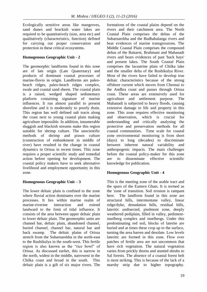
Homogenous Geographic Unit - 1
The landforms found in this unit are beach
ridges, beach ridges complex, swale, young
mud flats, brackish water creeks, beach and spit
which are of recent origin. The width of this
zone varies along the coastal areas but it
typically consists of young coastal plains, with
a contour of 10m depth in the sea. This is the
most dynamic region where the interaction of
different coastal processes likes waves, tidal
surge, storm surge and current takes place. This
is also the most sensitive area of coastal zone.
The boundary of HGU - 1 can be used as the
boundary of regulation zone. In order to
regulate this zone, it is necessary to have an
understanding of present land use conditions
and precise delineation of HTL (high tide line)
and LTL (low tide line). Severe cyclonic events
are mainly responsible for modifications of the
landscape in this zone in coastal Orissa.
Extreme weather events result in severe
shoreline changes, Thereby, affecting coastline
configuration: beach and dune erosion,
modifications of dune complexes, dune
breaching, over wash, inlet formation and at
many places, complete elimination of sand-
dune complexes. Coastal policy should have
some mechanism to adopt against extreme
events like protection and conservation of
ecological sensitive areas, managed retreat and
accommodate. Managed retreat means
constructing setback zones, shifting of
buildings, no development in susceptible areas,
relocation, realignment, creating upland
buffers, hazard insurance, appropriate land use,
regulation of hazard zones and an improved
drainage system.
M. Mishra / IJEGEO 3 (2), 11-23 (2016)
19
Ecologically sensitive areas like mangroves,
sand dunes and brackish water lakes are
required to be quantitatively (size, area etc) and
qualitatively (characteristics, function) defined
for carrying out proper conservation and
protection in these critical ecosystems.
Homogenous Geographic Unit - 2
The geomorphic landforms found in this zone
are of late origin (Late Quaternary) and
products of dominant coastal processes of
marine-fluvio in origin. Landforms are paleo-
beach ridges, paleo-beach ridges complex,
swale and coastal sand sheets. The coastal plain
is a raised, wedged shaped sedimentary
platform containing signature of marine
influences. It run almost parallel to present
shoreline and it is moderately to poorly drain.
This region has well defined salt tracts along
the coast next to young coastal plain making
agriculture impossible. In addition, innumerable
sluggish and blackish streams make this region
suitable for shrimp culture. The unscientific
methods of shrimp and prawn culture
(construction of embankment in middle of
river) have resulted in the change in coastal
dynamics in Orissa in recent times. This zone
requires a proper scientific study and remedial
action before opening for development. The
coastal policy makers have to seek alternative
livelihood and employment opportunity in this
zone.
Homogenous Geographic Unit – 3
The lower deltaic plain is confined to the zone
where fluvial action dominates over the marine
processes. It lies within marine realm of
marine-riverine interaction and extend
landward to the limit of tidal influence. It
consists of the area between upper deltaic plain
to lower deltaic plain. The geomorphic units are
channel bar, deltaic plain, abandoned channel,
buried channel, channel bar, natural bar and
back swamp. The deltaic plains of Orissa
stretch from the Subarnarekha in the north-east
to the Rushikulya in the south-west. This fertile
region is also known as the “rice bowl” of
Orissa. As discussed earlier, this is narrow in
the north, widest in the middle, narrowest in the
Chilka coast and broad in the south. This
deltaic plain is a gift of six major rivers. The
formations of the coastal plains depend on the
rivers and their catchment area. The North
Coastal Plain comprises the deltas of the
Subarnarekha and the Budhabalanga rivers and
bear evidences of marine transgressions. The
Middle Coastal Plain comprises the compound
deltas of the Baitarni, Brahmani and Mahanadi
rivers and bears evidences of past 'back bays'
and present lakes. The South Coastal Plain
comprises the lacustrine plain of Chilka lake
and the smaller delta of the Rushikulya River.
Most of the rivers have failed to develop true
deltaic characteristics because of the strong
offshore current which moves from Chennai to
the Andhra coast and passes through Orissa
coast. These areas are extensively used for
agriculture and settlement purpose. The
Mahanadi is subjected to heavy floods, causing
extensive damage to life and property in this
zone. This zone requires effective monitoring
and observation, which is crucial for
understanding and critically analysing the
protective and preservation methods for all
coastal communities. Time scale for coastal
zone environmental monitoring is from short
(days) to long (decades) to discriminate
between inherent natural variability and
anthropogenic impacts. The main challenges
before the coastal policy-maker for this zone
are to disseminate effective scientific
knowledge for publication.
Homogenous Geographic Unit - 4
This is the meeting zone of the arable tract and
the spurs of the Eastern Ghats. It is termed as
the 'zone of transition. Soil erosion is rampant
here. The landform found in this zone are
structural hills, intermontane valley, linear
ridge/dyke, denudation hills, residual hills,
lateritic undisected, piedmont zone, deeply
weathered pediplain, filled in valley, pediment-
inselberg complex and inselbergs. Under this
predominating red soil, blocks of laterite are
buried and at times these crop up to the surface,
turning the area barren and desolate. Low levels
lateritic are formed in this zone. Flow ever
patches of fertile area are not uncommon that
have rich vegetation. The natural vegetation
varies from prickly thorns and stunted shrubs to
Sal forests. The absence of a coastal forest belt
is most striking. This is because of the lack of a
marshy strip due to higher topography.
M. Mishra / IJEGEO 3 (2), 11-23 (2016)
20
Therefore, the most ideal step in this zone for
coastal managers would be to recognise coastal
geological processes, preserve natural
landforms, and promote afforestation.
Homogenous Geographic Unit - 5
Water bodies include river, lakes, creeks,
wetlands, estuaries and water ways. This zone
is most sensitive and lifeline of coastal
population of Orissa. The rivers from North to
South are the Subarnarekha, the Budha
Balanga, the Baitarni, the Brahmani, the
Mahanadi and the Rushikulya. The most
important reservoirs are at Balimela, on the
river Sileru, Rengali over the Brahmani,
Mandira over the Sankh, a tributary to the
Brahmani near Rourkela and upper Indravati in
the river Indravati. Among the natural ones,
Chilka Lake is the most famous lake in India.
The lake level fluctuates in different seasons.
The primary task of coastal policy-maker in this
zone is to use inter-disciplinary method and
tool to monitor water quality, integrated
industrial pollution control and environmental
risk assessment.
Fig. 3 Homogenous geographic unit of Orissa coast
Discussion and Conclusions
To date the research on coastal zone are more
on implementation of ICZM and pratical
objectivity are more driven by global problems
of climate change and global warming (Pethick
et al., 2003 & IPCC, 2013). Costal
managements in developing countries are more
highlighting the concept integrated assessment
of large scale complex problem in
oversimplified manner without practical
solution. The present unsustainable conditions
of Orissa coast reflect the unregulated
development in last four decades affecting the
amount sediment use to circulate within the
systems (Syvitski, et al., 2009 & Kumar et. al,
2010). The adhoc delineation of coastal zone
into CRZ and CZM in Odisha coast are done
arbitrarily without giving clear picture about
internal stakeholders, interactions and
sensitivity of coastal systems. This study has
attempted to provide a rational regionalization
of geomorphic landforms response to
perturbations, which is the critical component
of coastal managements. Although, mapping
the highly complex systems in micro scale in a
cumbersome job but advance geospatial
platforms has made it easy and also efficient
M. Mishra / IJEGEO 3 (2), 11-23 (2016)
21
tool for delineating homogenous unit without
errors and misclassification. This approach used
open sources data like Landsat ETM+ imagery,
ancillary data bases, DGPS field survey data
and also digital image processing at ERDAS &
ARC GIS platforms to map the coastal
geomorphic landforms at micro-scale. Addition
of digital LIDAR coastal changes product and
3D geophysical data sources are able to identify
coastal landforms with high precision and
accuracy (Zhou & Xie, 2009 & Allen et al.,
2012). These geospatial methods can be
replicated in other coastal region depending
upon specific management objective and set
goals of national coastal policy.
The prediction about changes in dynamic and
complex coastal systems should entail more on
long time period geomorphic data and further to
remain elusive goal of sustainable coastal zone
management policy. In summary, homogenous
geomorphic management unit based
regionalization should be starting point for
ICZM strategic plan. Rational regionalization
of landforms of Orissa coast to five
homogenous units should be integrated with
socio-economic characteristics of each unit for
developing overall integrated value and will be
spatial tool for implementation of coastal zone
management at micro-scale. Future, coastal
policy and programme should not depend upon
more protection and preservation but mapping
and identifying the spatial sensitive coastal
zone followed remedial measures in time.
Therefore, the task of coastal mangers in
developing countries is to locate and manage
these kinds of changes in coastal systems but
allow these systems to adjust naturally within
the ecosystems. The job of scientific
community is to provide society with a
carefully constructed spatial data base with a
defining precise limit of tolerance of coastal
systems for utilizing the resources in
sustainable manner in longer time periods.
References
Allan James, L.A., E. Hodgson, M.E.,
Ghoshal, S and Latiolais, M.M. (2012).
Geomorphic change detection using historic
maps and DEM differencing: The temporal
dimension of geospatial analysis,
Geomorphology 137, pp. 181–198.
Arnoff, S. (1982). Classification accuracy: a
user approach. Photogrammetric
Engineering and Remote Sensing, 48(8), pp.
1299–1307.
Bishop, M.P., James, L.A., Shroder, J.F.,
Walsh, S.J. (2012). Geospatial technologies
and digital geomorphological mapping:
concepts, issues and research.
Geomorphology 137, pp. 5–26.
CCD (1997). Revised Coastal Zone
Management Plan, Sri Lanka. Coast
Conservation Department, Ministry of
Fisheries and Aquatic Resources
Development, Sri Lanka, 1997.
Coastal Regulation Zone (CRZ) Notification
(2011). Ministry of Environment, Forests
and Climate Change, Govt. of India. (http://
www.moef.nic.in/downloads/public-
information/CRZ-Notification- 2011.pdf).
Costa, M.F., Araújo, M.C.B., Souza, S.T., and
Silva-Cavalcanti, J.S. (2008). Verticalização
Da Praia Da Boa Viagem (Recife,
Pernambuco) eSuas Consequências
Socioambientais. Revista Da Gestão
Costeira Integrada 8 (2), pp. 233–245.
Dramisa, F., Guidab, D., Cestari, A. (2011).
Nature and aims of geomorphological
mapping. In: Smith, M.J., Paron, P.,
Griffiths, J.S. (Eds.), Geomorphological
Mapping. Elsevier, Amesterdam,
Embabi, N.S., Badawy, M. (2014). A semi-
automated approach for mapping
geomorphology of El Bardawil Lake,
Northern Sinai, Egypt using integrated
remote sensing and GIS techniques.,
Egyptian Journal of Remote Sensing and
Space Sciences, Vol. 17, pp. 41-60.
Evans, I.S. (2012). Geomorphometry and
landform mapping: what is a landform?
Geomorphology 137, pp. 94–106.
Fresca, T.M. (2007). A Área Central de
Londrina: Uma Análise Geográfica. Revista
Geografia (Londrina., 16, (2), pp. 143-166.
Henriques, C. and Tenedório, J.A. (2009).
“Remote Sensing, GIS Application and
Simulation of Coastal Land Use Changes
Based on Cellular Automata: A Case Study
of Maputo, Mozambique.” Journal of
Coastal Research. 56, pp. 1518–1521.
M. Mishra / IJEGEO 3 (2), 11-23 (2016)
22
IPCC (2013). Summary for policymakers. In:
Stocker TF, Qin D, Plattner G-K, Tignor M,
Allen SK, Boschung J, Nauels A, Xia Y,
Bex V, Midgley PM (eds) Climate change
2013: the physical science basis.
Contribution ofWorking Group I to the Fifth
Assessment Report of the
Intergovernmental Panel on Climate
Change. Cambridge University Press,
Cambridge
Kaliraj, S. and Chandrasekar, N. (2012).
Spectral Recognition Techniques and MLC
of IRS P6 LISS III image for Coastal
Landforms Extraction along South West
Coast of Tamilnadu, India, Bonfring
International Journal of Advances in Image
Processing,2(3), pp. 1-7.
Kumar TS, Mahendra RS, Nayak S,
Radhakrishnan K, Sahu KC. (2010). Coastal
vulnerability assessment for Orissa State,
East coast of India. J Coast Res 26, pp.
523–534.
Lin, T., Xue, X., Shi, L., and Gao, L. (2013).
Urban Spatial Expansion and Its Impacts on
Island Ecosystem Services and Landscape
Pattern: A Case Study of the Island City of
Xiamen, Southeast China. Ocean & Coastal
Management. 81, pp. 90–96.
Magarotto, M., Costa, C., Tenedório,
J.A.,Silva, C.P., Pontes, T. (2014).
Methodology for the development of 3D
GIS models inthe Coastal Zone. In: Green,
A.N. and Cooper, J.A.G.(eds.), Proceedings
13th International Coastal Symposium
(Durban, South Africa), Journal of Coastal
Research, Special IssueNo. 70, pp. 479-484,
ISSN 0749-0208.
Mishra, M and Sharma, M. (2009). Assesment
of coastal geomorphic processes in Erasama
block, Jagatsinghpur District, Orissa,
Journal of Geomatica, 3 (2), pp. 63 – 68.
Mishra, M. (2013). Mapping beach ridges
complex with geospatial techniques,
Jatadhar Muhan Creek, Odisha, India, 2 (3),
pp. 1- 11.
Moawad, B.M. and Khidr, M.M. (2011). A
GIS and RS based approach for modeling
ungauged small-scale catchments in Mersa
Alam. Bull. Soc. Ge´ogr. E´ gypte 84, pp.
117–140.
Nayak, S. (1991). Manual for Mapping of
Coastal Wetlands/Land Forms and
Shoreline Changes Using Satellite Data.
Technical Note. Ahmedabad: Space
Applications Centre, IRS UP/SAC/MCE/
SN/32/91, 63p.
OECD, (1992). Recommendations of the
Council on Integrated Coastal Zone
Management, Organization for Economic
Co-peration and Development, Paris.
Pethick, J.S. and Crooks, S. (2000).
Development of a coastal vulnerability
index: a geomorphological perspective.
Environmental Conservation, 27, pp. 359–
367.pp. 39–73.
Qin, C., Zhu, A., Shi, X., Li, B., Zhou, C.
(2009). Quantification of spatial gradation
of slope positions. Geomorphology 110, pp.
152– 161.
Seijmonsbergen, A.C. (2012). Current trends in
geomorphological mapping. Geophysical
Research Abstracts, vol. 14, EGU 2012–
6114, 2012, EGU General Assembly,
Vienna.
Seijmonsbergen, A.C., Hengl, T., Anders, N.S.
(2011). Semi-automated identification and
extraction of geomorphological features
using digital elevation data. In: Smith,M.J.,
Paron, P., Griffiths, J.S. (Eds.),
Geomorphological Mapping. Elsevier,
Amsterdam, pp. 297–335.
Silva, C., Alves, F., and Rocha, R., (2007). The
management of beach carrying capacity:
The case of northern Portugal. Journal of
Coastal Research, 50, pp. 135–139.
Sinha, B.H. (1971). Geography of Orissa,
National book trust, New Delhi India.
Srinivasa Kumar T, Mahendra RS, Nayak S,
Radhakrishnan K, Radhakrishnan KC
(2010). Coastal vulnerability assessment for
Orissa state, East coast of India. J Coast Res
26(3), pp. 523–534.
Syvitski, J.P.M., Kettner, A.J. Overeem, I.,
Hutton, E.W.H., Hannon, M.T.
Brakenridge, J.R., Day, J., Vörösmarty, C.,
Saito, Y., Giosan, L & Nicholls, R.J.
(2009). sinking deltas due to human
activities, Nature Geosciences, 2, pp. 681 –
686.
Theenadhayalan, G., Kanmani, T. and
Baskaran, R. (2012). Geomorphology of the
Tamil Nadu Coastal Zone in India:
Applications of Geospatial Technology,
Journal of Coastal Research, 28(1), pp.
149-160.
M. Mishra / IJEGEO 3 (2), 11-23 (2016)
23
UNEP (United Nations Environment
Programme) (2007). Physical alteration and
destruction of habitats. www.unep.org.
Vannametee, E., Babel, L.V., Karssenberg, D.,
Schuur, J., Hendriks, M. R., Bierkens,
M.F.P (2012).Automated geomorphological
mapping using Multiple Point Geostatistics.
Geophysical Research Abstracts, 14, EGU
2012–2765, EGU General Assembly,
Vienna.
Wilson, J.P. (2012). Digital terrain modeling.
Geomorphology 137, pp. 107–121.
Ya´n˜ ez-Arancibia A., J. W. Day. (2004).
Environmental subregions in the Gulf of
Mexico coastal zone: the ecosystem
approach as an integrated management tool.
Ocean Coast Manage 47, pp. 727–757.
Yu, B., Liu, H., Wu, J., Hu, Y., and Zhang, L.
(2010). Automated Derivation of Urban
Building Density Information Using
Airborne LiDAR Data and Object-based
Method. Landscape and Urban Planning,
98, pp. 3-4.
Zhou, G., Xie, M. (2009). Coastal 3-D
morphological change analysis using
LiDAR series data: a case study of
Assateague Island National Seashore.
Journal of Coastal Research 25, 435–447.