Embed Size (px)
Citation preview

GS-21 GEOLOGY OF THE EDMUND LAKE AREA (NTS 53K/11NW)
by M.T. Corkery and L.M. Heaman1
Corkery, M.T. and Heaman L.M. 1998: Geology of the Edmund Lake area (NTS 53K/11NW); in Manitoba Energy and Mines, GeologicalServices, Report of Activities, 1998, p. 103-110.
103
SUMMARY
Supracrustal rocks in the Edmund Lake area form a westward-thinning, east-plunging, north-facing homoclinal extension of the StullLake greenstone belt. They are flanked by felsic intrusive/gneiss terranesto the north, south and west. The most significant observations are that:1) Hayes River Group basalt forms a thick sequence of tholeiitic basaltwith a MORB- like geochemical signature, 2) the geochemical signatureof the basalt north of the "Wolf Bay" shear zone indicates affinity to thediverse sequence of the Oxford Lake Group, and 3) the White Housetonalite (2734±2 Ma) provides a minimum age of the Hayes RiverGroup, but, more significantly indicates that rocks of Oxford Lake Groupage, has geochemistry similar to Oxford Lake Group felsic extrusiverocks in the area and intrudes Hayes River Group rocks.
INTRODUCTION
Manitoba's segment of the Stull Lake map area is being mappedunder the auspices of Manitoba's Northern Superior Project and theWestern Superior NATMAP project. The Stull Lake area was lastmapped in the 1930's (Downie, 1936a, 1936b), and is currently beingreexamined to gain a better understanding of, and assess the mineralpotential of, greenstone belts in this northern frontier region.
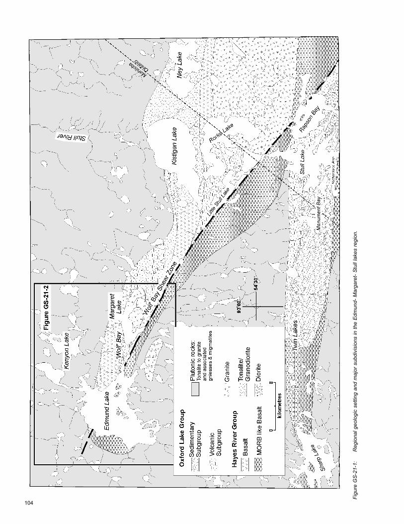
The Stull Lake area straddles the Ontario/Manitoba borderbetween latitudes 54º and 55º north. Cooperative geoscience studies inthe area are being carried out by the Geological Survey of Canada,Ontario Geological Survey, Manitoba Geological Services Branch andtwo universities as part of the Western Superior NATMAP Project.Current projects in this region by Manitoba Geological Services Branchhave targeted the Archean greenstone belts (Fig. GS-21-1) at Edmund- Margaret lakes (Corkery, 1996a, b, 1998) and Stull Lake (Corkery et.al., 1997a, b; Corkery and Skulski, GS-22 this volume) in conjunctionwith more thematic structural studies (Jiang and Corkery, GS 23 thisvolume).
A program of regional 1:50 000 scale mapping by Denver Stoneof the Ontario Geological Survey began in 1995 in the Stull Lake area(Stone and Pufahl, 1995) and has continued with mapping of several1:50 000 NTS sheets in the region. A shared field camp and mappingprogram in both 1997 and 1998 have produced a cross-border OGSpreliminary series compilation map of the Little Stull Lake area (Stoneand Halle, 1997) and joint release of the Stull Lake sheet (53K/9) isplanned for January 1998. The Geological Survey of Canada is involvedin integrated mapping, geochemical and geochronological programs inboth provinces and structural-tectonic studies have been initiatedthrough the University of New Brunswick.
This paper will report on geological mapping in the summer of1998 in the Edmund Lake (53K/11 NW) area (Fig GS-21-1) andgeochronological and geochemical results for the area mapped to theeast (53K/11 NE).
GENERAL GEOLOGY
Supracrustal rocks in the Edmund Lake area form a westward-thinning, east-plunging, north-facing homoclinal extension of the StullLake greenstone belt (Fig. GS-21-1). The supracrustal rocks areflanked by felsic intrusive/gneiss terranes to the north, south and west.The eastern end of the Gods Lake greenstone belt occurs 10 km to thewest along strike. A major linear deformation zone trends 310° acrossthe map area and extends to the southeast into the Little Stull Lakearea. This deformation zone ("Wolf Bay" shear zone) divides the beltinto Northern and Southern domains. The Southern domain is dominated
by pillowed and massive basalt flows thathave historically been assigned to theHayes River Group (Downie, 1937). Thebasalt is intruded by gabbro and felsicdykes and two small plutons (the White House tonalite and the MargaretLake granite). The Northern domain consists of more diverse lithologiesthat consist predominantly of pillowed basalt, mafic volcaniclastic rocks,felsic volcaniclastic rocks, iron formation and sedimentary rocks, thatoccur sporadically along the northern edge of the "Wolf Bay" shearzone. Downie (1936a) assigned most of these rock types to the OxfordLake Group. Numerous gossan zones occur both within these units andto the south within the shear zone.
Descriptions of the lithologies that dominate the Edmund Lakearea were reported in 1996 (Corkery, 1996b) and new mapping hasextended these same units to the west. Only new units and synopticdescriptions required for discussion of the geochemical and geochrono-logical data will be included here.
SUPRACRUSTAL BELT ASSOCIATIONS
The area mapped this summer (53K/11 NW) (Corkery 1998) liessoutheast of the "Wolf Bay" shear zone. In the map area, allsupracrustal rocks are part of Hayes River Group Southern domainbasalts and associated gabbro-diorite intrusions. Supracrustal unitsbelonging to the Oxford Lake Group, mapped to the northeast of the"Wolf Bay" shear zone (Fig. GS-21-2), were absent from this area.
Hayes River Group (Southern domain)Primary layering and top indicators are rare, similar to the area
to the east. However, where present, layering is moderately- to steeply-northeast dipping and northwest trending. This layering is parallel to aweak- to moderately-developed plane of flattening in the basalt. Boththe layering and flattening are consistently transected, at an acuteclockwise angle, by a strongly developed, west-northwest trendingregional fabric parallel to the "Wolf Bay " shear zone. The sole mappablemarker horizon in the sequence (plagioclase porphyritic basalt - unit 1d)is not folded (Corkery, 1996a). These relationships indicate that thesequence is homoclinal and northeast-facing.
Gabbro dykes and sills intrude the basalt throughout theSouthern domain. In upper part of the section they form only about 10% of the exposed section, but they increase dramatically down sectionto the southwest where they commonly comprise over 50 % of the section.Intrusions range from small (1 - 2 m) aphanitic dykes, to sills that areover one hundred metres thick. Feathery, radiating, 3 to 7 mm aggregatesof mafic minerals (actinolite?) form mafic clots in thicker sills. Pyroxene(pseudomorphed by amphibole) phyric gabbro with phenocrysts up to 7mm, forms a minor dyke phase commonly associated with pyroxenephyric basalt.
Based on the presence or absence of phenocrysts, variation incolour of the fresh surface, and the distribution of secondary featuressuch as spherulites pillowed and massive basalt flows in the Southerndomain are subdivided into four subunits: 1) dark green- to green-grey,aphyric basalt flows (subunit 1a) are most abundant; they are interlayeredwith; 2) pale green to blue- green aphyric flows (subunit 1c) that wereoriginally considered to be slightly more siliceous (basaltic andesite); 3)plagioclase phyric flows occur in the upper portion of the section andform a northwest-trending marker that continues into the "Wolf Bay"shear zone (Fig. GS-21-2); and 4) dark green to green-grey pyroxenephyric massive and pillowed basalt flows are rare and show an irregulardistribution in the section.
1Department of Earth and Atmospheric Sciences, University of Alberta, Edmonton, Alberta, Canada T6G 2E3
104
Figu
re G
S-21
-1:
Reg
iona
l geo
logi
c se
tting
and
maj
or s
ubdi
visi
ons
in th
e Ed
mun
d- M
arga
ret-
Stul
l lak
es re
gion
.

105
Figure GS-21-2: General geology of the Edmund Lake area.
The basaltic rocks in the Southern domain are all geochemicallysimilar. They plot in the tholeiitic field in tight clusters on major elementplots (AFM (Irving and Baragar, 1971), Jensen (1976) ternary cation plotand SiO2 vs. FeO*/MgO) (Fig. GS-21-3a, 3b, 3c). The most abundantaphyric flows of units 1a and 1c are indistinguishable on both rare earthelement (REE) and incompatible element primitive mantle normalizeddiagrams (Fig GS-21-4a and 4b). In general they have depleted lightrare earth element (LREE) and large ion lithophile (LIL) profiles andrelatively flat heavy rare earth element (HREE) profiles. Some variationsare apparent between the aphyric and the phyric basalt units of theSouthern domain. The plagioclase-bearing basalt flows have a slightlyelevated light rare earth profile (Fig. GS-21-4c) and have relativeenrichment of La > Th > Nb. (Fig. GS-21-4d). The only analysis of thepyroxene phyric basalt displays a depleted LREE profile, and flat HREEprofile (Fig. GS 21-4d), and strongly depleted LIL with Th< Nb < La. Thisanalysis also shows significantly elevated Sr common to all the basaltin the region. Elevated Sr may be the result of a regionally extensivealteration event.
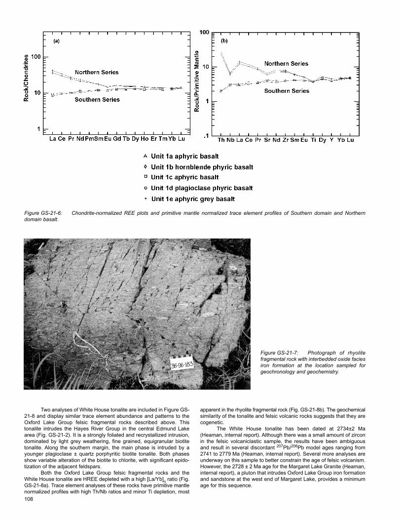
North of the "Wolf Bay" shear zone, the basalt of the Northerndomain have similar outcrop characteristics to the Southern domainbasalt. These aphyric basalt flows (unit 1e) are dark-grey to black, onthe fresh surface, and grade to the north into amphibolite derived frompillowed and massive basalt flows (unit 1f). These rocks were interpretedto be higher metamorphic grade equivalents of unit 1a (Corkery, 1996b).However, they are geochemically distinct: they plot in the calc-alkaline
field on a SiO2 vs. FeO*/MgO diagram (Fig. GS-21-5). The Northerndomain basalt have strongly enriched LREE patterns compared to units1a and 1b (Fig. GS-21-6a) and high Th/Nb ratios (Fig. GS-21-6b).These features are similar to the patterns described for basalt flows onthe south shore of Kistigan Lake north of the "Wolf Bay" shear zone inthe Little Stull Lake area (Corkery and Skulski, GS 22 this volume) andfurther interpretation of the significance of these geochemical patternsand their interpretations are made in that report.
Oxford Lake Group A highly diverse sequence of volcaniclastic and sedimentary
rocks forms a narrow discontinuous band up to 500 m wide along thenorth flank of the "Wolf Bay" shear zone in the Margaret Lake area.They pinch out to the west along the north edge of the "Wolf Bay" shearzone and are intruded to the east by the Margaret Lake granite. In generalthese rocks are strongly flattened, foliated and transposed parallel tothe shear zone. However, some outcrops retain delicate primarydepositional features. In close proximity to the "Wolf Bay" shear zone,Oxford Lake Group rocks are commonly strongly altered, producing alight grey and black mottled fresh surface, with muscovite and sulphidesalong fractures and significant sulphide-bearing gossan zones.
Massive and fragmental felsic volcanic rocks are the dominantlithologies in this group, including pale green to light green-beigeweathering aphyric dacite to rhyolite. A felsic fragmental rock (Fig. GS-21-7) was sampled for geochronology and geochemistry.

106
Figure GS-21-3: Major element plots for all subunits of the Hayes River Group basalts in the Southern domain. All analyses plot in a tight clusterin the tholeiitic field on a) AFM (Irving and Baragar 1971), b) Jensen (1976) ternary cation plot and c) SiO2 vs. FeO*/MgO).

107
Figure GS-21-4: Chondrite-normalized REE plots and primitive mantle normalized trace element profiles of Hayes River Group basalts (normalizationfactors from Sun and McDonough, 1989). Plots a and b are aphyric basalt, c and d are plagioclase and pyroxene phyric basalt.
Figure GS-21-5: SiO2 vs. FeO*/MgO plot comparingtholeiitic Southern domain basalts to calc-alkaline Northerndomain basalt.
108
Figure GS-21-6: Chondrite-normalized REE plots and primitive mantle normalized trace element profiles of Southern domain and Northerndomain basalt.
Figure GS-21-7: Photograph of rhyolitefragmental rock with interbedded oxide faciesiron formation at the location sampled forgeochronology and geochemistry.
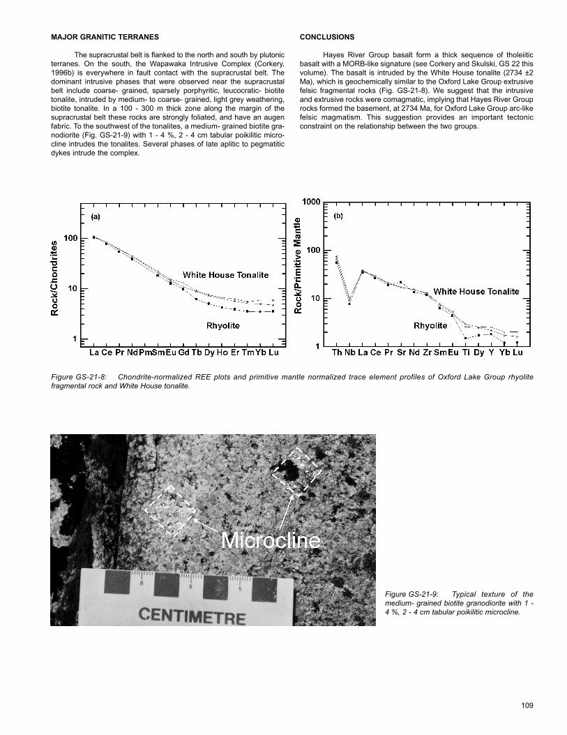
Two analyses of White House tonalite are included in Figure GS-21-8 and display similar trace element abundance and patterns to theOxford Lake Group felsic fragmental rocks described above. Thistonalite intrudes the Hayes River Group in the central Edmund Lakearea (Fig. GS-21-2). It is a strongly foliated and recrystallized intrusion,dominated by light grey weathering, fine grained, equigranular biotitetonalite. Along the southern margin, the main phase is intruded by ayounger plagioclase ± quartz porphyritic biotite tonalite. Both phasesshow variable alteration of the biotite to chlorite, with significant epido-tization of the adjacent feldspars.
Both the Oxford Lake Group felsic fragmental rocks and theWhite House tonalite are HREE depleted with a high [La/Yb]n ratio (Fig.GS-21-8a). Trace element analyses of these rocks have primitive mantlenormalized profiles with high Th/Nb ratios and minor Ti depletion, most
apparent in the rhyolite fragmental rock (Fig. GS-21-8b). The geochemicalsimilarity of the tonalite and felsic volcanic rocks suggests that they arecogenetic.
The White House tonalite has been dated at 2734±2 Ma(Heaman, internal report). Although there was a small amount of zirconin the felsic volcaniclastic sample, the results have been ambiguousand result in several discordant 207Pb/206Pb model ages ranging from2741 to 2779 Ma (Heaman, internal report). Several more analyses areunderway on this sample to better constrain the age of felsic volcanism.However, the 2728 ± 2 Ma age for the Margaret Lake Granite (Heaman,internal report), a pluton that intrudes Oxford Lake Group iron formationand sandstone at the west end of Margaret Lake, provides a minimumage for this sequence.
109
Figure GS-21-8: Chondrite-normalized REE plots and primitive mantle normalized trace element profiles of Oxford Lake Group rhyolitefragmental rock and White House tonalite.
Figure GS-21-9: Typical texture of themedium- grained biotite granodiorite with 1 -4 %, 2 - 4 cm tabular poikilitic microcline.
MAJOR GRANITIC TERRANES
The supracrustal belt is flanked to the north and south by plutonicterranes. On the south, the Wapawaka Intrusive Complex (Corkery,1996b) is everywhere in fault contact with the supracrustal belt. Thedominant intrusive phases that were observed near the supracrustalbelt include coarse- grained, sparsely porphyritic, leucocratic- biotitetonalite, intruded by medium- to coarse- grained, light grey weathering,biotite tonalite. In a 100 - 300 m thick zone along the margin of thesupracrustal belt these rocks are strongly foliated, and have an augenfabric. To the southwest of the tonalites, a medium- grained biotite gra-nodiorite (Fig. GS-21-9) with 1 - 4 %, 2 - 4 cm tabular poikilitic micro-cline intrudes the tonalites. Several phases of late aplitic to pegmatiticdykes intrude the complex.
CONCLUSIONS
Hayes River Group basalt form a thick sequence of tholeiiticbasalt with a MORB-like signature (see Corkery and Skulski, GS 22 thisvolume). The basalt is intruded by the White House tonalite (2734 ±2Ma), which is geochemically similar to the Oxford Lake Group extrusivefelsic fragmental rocks (Fig. GS-21-8). We suggest that the intrusiveand extrusive rocks were comagmatic, implying that Hayes River Grouprocks formed the basement, at 2734 Ma, for Oxford Lake Group arc-likefelsic magmatism. This suggestion provides an important tectonicconstraint on the relationship between the two groups.

110
REFERENCES
Corkery, M.T.1998: Geology of the Edmund Lake Area (53K/11NW); Manitoba
Energy and Mines, Minerals Division, Preliminary map1998 S1, 1:20 000.
1996a: Geology of the Edmund Lake Area (53K/11NE); ManitobaEnergy and Mines, Minerals Division, Preliminary map1996 S1, 1:20 000.
1996b: Geology of the Edmund Lake Area (53K/11NE); inManitoba Energy and Mines, Minerals Division, Report ofActivities 1996, p. 11-13.
Corkery, M.T., Davis, D.W. and Lenton, P.G.1992: Geochronological constraints on the development of the
Cross Lake greenstone belt, northwest Superior Province,Manitoba; Canadian Journal of Earth Sciences, v. 29, No.10, 1992, p. 2171-2185.
Corkery, M.T., Skulski, T.1998: Geology of the Little Stull Lake area (part of NTS 63K/10
and 7); in Manitoba Energy and Mines, Geological services,Report of Activities 1998, p. 111-118.
Corkery, M.T., Skulski, T. and Whalen, J.B.1997a: Geology of the Little Stull Lake Area (Part of NTS 53K10);
Manitoba Energy and Mines, Minerals Division,Preliminary map 1997 S1, 1:20 000.
1997b: Geology of the Little Stull Lake Area (Part of NTS 53K10);in Manitoba Energy and Mines, Minerals Division, Reportof Activities, 1997, p. 13-17.
Corkery, M.T., Skulski, T. and Whalen, J.B.1998: Geology of the Little Stull Lake Area (Part of NTS 53K/10
and 7); Manitoba Energy and Mines, Geological Services,Preliminary map 1998 S2, 1:25 000.
Downie, D.L.1937 Stull (Mink) Lake area, Manitoba; Canada Department of
Mines and Resources, Mines and Geology Branch, Paper37-7.
1936a: Stull Lake Sheet (East half); Canada Department of Minesand Resources, Mines and Geology Branch, Map 452A.
1936b: Stull Lake Sheet (West half); Canada Department of Minesand Resources, Mines and Geology Branch, Map 451A.
Irvine, T.N. and Baragar, W.R.A.1971: A guide to the chemical composition of common volcanic
rocks; Canadian Journal of Earth Sciences, v. 8, p. 523-548.
Jensen, L.S.1976: A new cation plot for classifying subalkaline volcanic
rocks; Ontario Department of Mines, Miscellaneous Paper66.
Jiang and Corkery 1998: A preliminary structural analysis of the Edmund Lake -
Little Stull Lake area, Northwestern Superior Province,Manitoba (part of NTS 63K/10, 11 and 7); in ManitobaEnergy and Mines, Geological Services, Report ofActivities 1998, p. 119-126.
Stone, D. and Halle, J.1997: Geology of the Sachigo, Stull and Yelling Lakes area: an
overview; in Summary of Field Work and other Activities1997, Ontario Geological Survey, Miscellaneous Paper168, p.67-71.
Stone, D. and Pufahl, P.1995: Geology of the Stull Lake Area; Northern Superior
Province, Ontario; in Summary of Field Work and otherActivities 1995, Ontario Geological Survey, MiscellaneousPaper 164, p.48-51.
Sun, S.s- and McDonough, W.F.1989: Chemical and isotopic systematics of oceanic basalts:
implications for mantle composition and processes; inA.D. Saunders and M.J. Norry (editors), Magmatism in theOcean Basins. Geological Society of London, SpecialPublication, 42, 313-345.