Embed Size (px)
Citation preview

SPS-03
S T A T E O F A R K A N S A S
ARKANSAS GEOLOGICAL SURVEY
Bekki White, State Geologist and Director
S T A T E P A R K S E R I E S 0 3
G E O L O G Y O F T H E C R A T E R O F D I A M O N D S S T A T E P A R K A N D V I C I N I T Y ,
P I K E C O U N T Y , A R K A N S A S
by
J. M. Howard and W. D. Hanson
Little Rock, Arkansas
2008

STATE OF ARKANSAS
Mike Beebe, Governor
ARKANSAS GEOLOGICAL SURVEY
Bekki White, State Geologist and Director
COMMISSIONERS
Dr. Richard Cohoon, Chairman………………………………………....Russellville William Willis, Vice Chairman…………………………………...…….Hot Springs David J. Baumgardner………………………………………….………..Little Rock Brad DeVazier…………………………………………………………..Forrest City Keith DuPriest………………………………………………………….….Magnolia Becky Keogh……………………………………………………...……..Little Rock David Lumbert…………………………………………………...………Little Rock
Little Rock, Arkansas
2008
i

TABLE OF CONTENTS
Introduction…………………………………………………………………………..................... 1
Geology…………………………………………………………………………………………... 1
Prairie Creek Diatreme Rock Types……………………………….…………...……...………… 3
Mineralogy of Diamonds…………………….……………………………………………..……. 6
Typical shapes of Arkansas diamonds…………………………………………………………… 6
Answers to Frequently Asked Questions……………..……………………………….....……… 7
Definition of Rock Types……………………………………………………………………… 7
Formation Processes.…...…………………………………………………………….....…….. 8
Search Efforts……………...……………………………...……………………...………..…. 11
Economic Concerns…………………………………………………………………………... 11
Mineral Identifications……………………….………………………………………………. 12
Misconceptions………………………………………………………………………………. 12
References and Reading List ………………….…………………..………………………...…. 13
Alphabetical Listing of Minerals reported from the Prairie Creek Diatreme and their Geologic
Associations………………………………………………………………………….…...... 14 Figures
Figure 1. General location of the Crater of Diamonds State Park within Arkansas…..... 1
Figure 2 General stratigraphy of the local rock units……….………………..….......… 2
Figure 3 Map and cross-section of Prairie Creek.….................…………………….…. 3
Figure 4. Magmatic lamproite boulders on crest of Middle Hill.…..……………….… 4
Figure 5. Lamproite lapilli tuff exposed on West Hill………………………………….. 5
Figure 6. Altered lamproite breccia tuff…….…………………...………………........… 5
Figure 7. Outcrop of silica-cemented sandstone-dominated maar epiclastics…..……… 6
Figure 8. Diamond dissolution evolution…………………….…………….………....… 7
ii
GEOLOGY OF THE CRATER OF DIAMONDS STATE PARK AND VICINITY, PIKE COUNTY, ARKANSAS
by
J. MICHAEL HOWARD AND W. D. HANSON
INTRODUCTION The Crater of Diamonds State Park is remarkable in several ways. First, it is the only place in the world where anyone may pay a small entrance fee, look for diamonds, and keep what you find! It fascinates geologists because the site presents a window into the geologic past and the earth’s mantle, a rare thing indeed. The park and surrounding area has a rich verbal and written history…history of the settlement of the region, of the discovery of diamonds, of the many attempts at commercial and tourist development based on the presence of that gemstone, and history of preservation and continued development since it became a state park and, as such, public property.
Figure 1: General location of the Crater of Diamonds State Park within Arkansas.
This publication is written to accompany the geologic poster by the Arkansas Geological
Survey entitled “Geology of the Crater of Diamonds State Park and Vicinity, Pike County, Arkansas.” The reader can learn a lot of geology and geologic history pertaining to the sedimentary and igneous rocks of the area, and specifically of the Park, from the poster and even more by reading the contained information. The geologic story is a fascinating one, not just for geologists, but for anyone wishing to learn why the diamonds are present, their age, and the past environment that existed when the diamondiferous igneous rocks were explosively emplaced. Key questions to be answered also include what is so unusual about these rocks, why do they weather so rapidly, how old are the rocks and the diamonds, along with many other questions. The authors hope you enjoy your travels through geologic time as we will be your guides. After the geology and mineralogy sections and before the reading list are frequently asked questions. It is hoped the answers to these questions will assist the visitor in better understanding the geology of the Park. GEOLOGY Crater of Diamonds State Park is just south of the Ouachita Mountains in Pike County, Arkansas and along the northern margin of the West Gulf Coastal Plain. The Ouachita Mountains region is an area of major disturbance on the southern margin of what is now called the North American
1

continent. Sediments that were deposited in a deep ocean basin south of the continental margin, dating from 500 to 245 million years ago, were shoved up and onto the continent and were “welded” to the continental mass by the end of the mountain-building episode at the close of Pennsylvanian time. Since then, weathering and erosion have taken their toll on this east-west mountain chain, resulting in a subdued relief relative to when it first was formed.
Figure 2: General stratigraphy of the local
rock units. The oldest rock unit displayed on the poster and on the stratigraphy chart (fig. 2) outcrops north of Murfreesboro and is named the Jackfork Sandstone. Its mapped extent is represented by the color gray. Locally, the sandstone beds dip steeply to the south due to their distortion during the Ouachita orogeny (mountain building episode). Where unweathered, it has been a major source of crushed sandstone for aggregate.
Cretaceous sedimentary rocks were deposited on the southern margin of the Ouachita Mountains and range in age from 144 – 66.4 million years. They represent sediments that were deposited in very shallow water on the northern margin of the Cretaceous seas. The beds dip gently to the south and now outcrop from near Arkadelphia in Clark County west to the Arkansas-Oklahoma state border near DeQueen in Sevier County. Cretaceous rocks are displayed on the poster and chart in varying shades of green. The Cretaceous units have been eroded by local rivers and streams. Deposits of those rivers and streams during the Quaternary date from 1.6 million years ago to recent times and are displayed in shades of yellow on the poster. Both Cretaceous and Quaternary units are located within the West Gulf Coastal Plain region of Arkansas. Along this coastal margin, about 100 million years ago, several explosive events happened, resulting in the emplacement of diamond-bearing rocks that geologists term lamproite breccia and tuff as a diatreme. A diatreme is a breccia-filled volcanic pipe formed by a gaseous explosion. The source of rocks that compose the exposures of the Prairie Creek pipe, exposed on the surface at the Crater of Diamonds State Park, and the other known bodies of similar igneous materials to the immediate northeast was the earth’s mantle. Some field evidence indicates that this pipe was emplaced on the seaward side of the ocean-land margin, perhaps only a very short distance off shore. Soon after the explosive event, magmatic lamproite, arising through the explosive vent, reached the surface and created lava-filled lakes within the existing crater.
2

Afterward, geologic processes became less catastrophic and the ongoing active cycle of deposition along the continental margin during the Cretaceous buried the volcanic vents. Only late in the Quaternary did the Little Missouri River erode those sediments capping the pipe and expose the larger pipe to erosion (fig. 3). From field relationships with the adjacent pipes, geologists estimate that only about 165 feet of erosion has taken place on the Prairie Creek pipe since its emplacement. It is geologically remarkable to have some of the rock types at the Crater of Diamonds State Park exposed. Worldwide, few of these types of pipes have the upper layers of rock material preserved. Most have suffered intensive weathering and deep erosion.
Prairie Creek Diatreme Rock Types Surface exposed rock types of the diatreme, may be divided into three general groups: magmatic lamproite, pyroclastic lamproite, and maar epiclastics. Magmatic lamproite contains only very few micro-diamonds, whereas pyroclastic lamproite is the source of the soil from which all the diamonds are recovered. The maar epiclastics are thought to contain some diamonds but have not been tested to determine their content. Data gathered during the 1990’s exploration work indicates a deep weathering and alteration zone of some 40 feet or more. Unaltered rock samples are therefore unavailable by surface sampling.
Figure 3: Map and cross-section of Prairie Creek. Modified from Morgan, 1993.
3

Magmatic Lamproite Originally termed peridotite by early investigators and later hypabyssal olivine lamproite and pyroxene (diopside) madupitic lamproite by recent workers, the rock is a magmatic non-explosive phase material. The rock is somewhat resistant to weathering and consists of crystals and crystal fragments of olivine, in various stages of alteration to serpentine, set in a fine matrix of poikilitic phlogopite, diopside, magnetite, and perovskite. Magmatic lamproite may contain xenoliths of rocks from the mantle and crust, brought along by its movement to the earth’s surface. Good exposures of this rock may be seen immediately north and down slope from the old mine shack within the search area and along Prospectors Trail where it forms bouldery masses on the crest and north side of Middle Hill (fig. 4).
Figure 4 : Magmatic lamproite boulders on
crest of Middle Hill.
Pyroclastic Lamproite This rock was originally termed kimberlite by early workers simply because it contained diamonds. Pyroclastic lamproite may be subdivided generally into two field identifiable types: lamproite lapilli tuff and lamproite breccia tuff. Microscopic
examination of thin sections of these rocks allows further descriptive terminology such as lamproite lapilli ash tuff and lamproite ash lapilli tuff. The soils derived from these units are the source of the diamonds. These units are not divided on the bedrock geology map. These rocks weather rapidly because most of the minerals composing them formed at great depth and are very unstable at surface temperatures and pressures. Lamproite Lapilli Tuff This rock represents fine-grained ash and dust that was formed by the initial explosion and settled as air fall material. Some of this material exhibits cross-bedding, indicative of the presence of water on the site that has either reworked the original ash or that the ash was deposited in water and then reworked. Tuff varies greatly in texture from one hand specimen to another. Some specimens consist of grains and fragments that average less than 1 mm (.04 inch). Such rocks appear even-grained. Other specimens may contain fragments and grains up to 1 cm (0.4 inch) in diameter with much finer grained matrix (fig. 5). Finally, a few samples contain a predominance of these larger grains and little fine-grained matrix. Phlogopite mica is present in all samples, often a major component, and typically is fine-grained. Also present are many small white to pale yellow grains of serpentine, probably representing weathered olivine. Exposures of this rock are present in the southwestern portion of the search area, as displayed on the poster. A significant number of diamonds have been recovered from soils developed on this rock type.
4
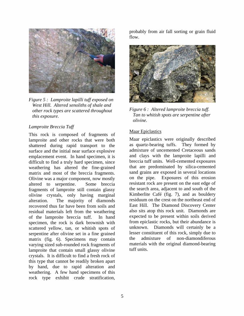
Figure 5 : Lamproite lapilli tuff exposed on West Hill. Altered xenoliths of shale and other rock types are scattered throughout this exposure.
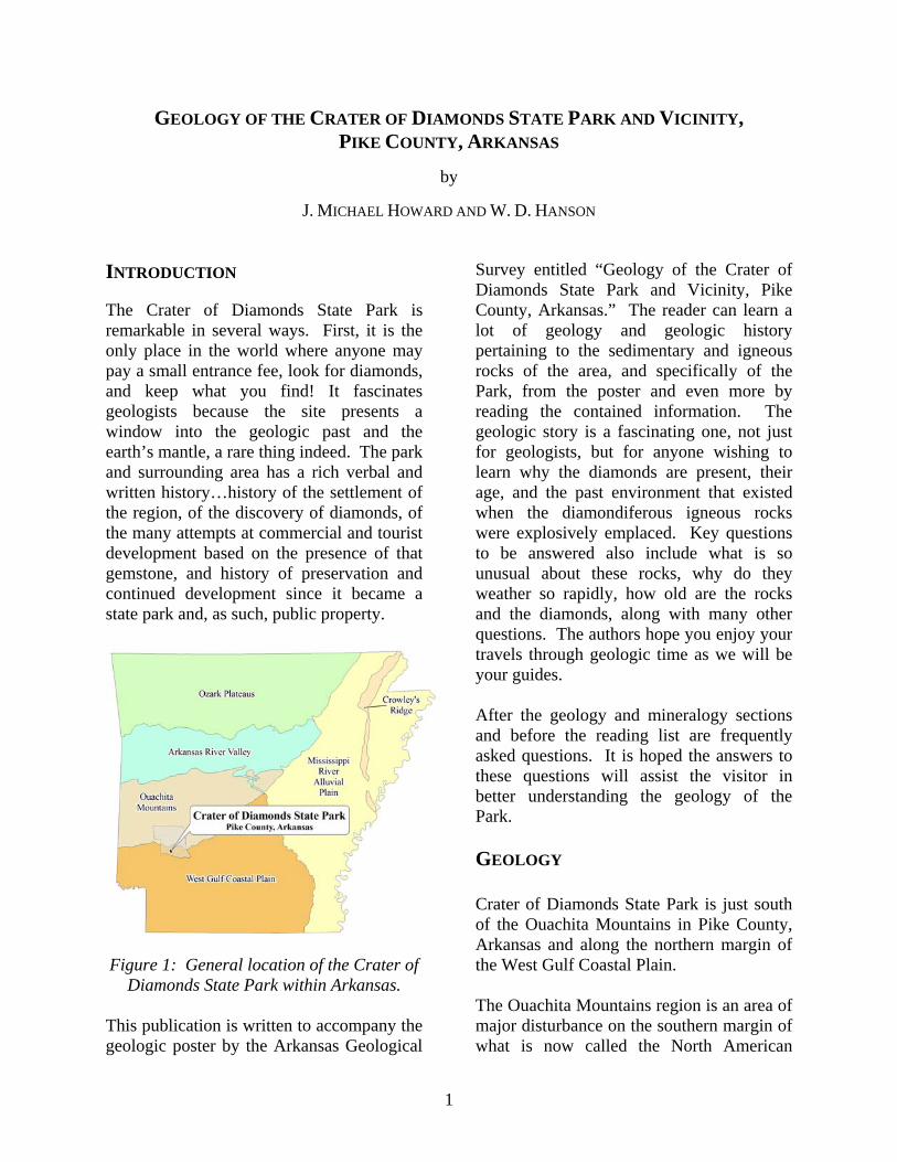
Lamproite Breccia Tuff
This rock is composed of fragments of lamproite and other rocks that were both shattered during rapid transport to the surface and the initial near surface explosive emplacement event. In hand specimen, it is difficult to find a truly hard specimen, since weathering has altered the fine-grained matrix and most of the breccia fragments. Olivine was a major component, now mostly altered to serpentine. Some breccia fragments of lamproite still contain glassy olivine crystals, only having marginal alteration. The majority of diamonds recovered thus far have been from soils and residual materials left from the weathering of the lamproite breccia tuff. In hand specimen, the rock is dark brownish with scattered yellow, tan, or whitish spots of serpentine after olivine set in a fine grained matrix (fig. 6). Specimens may contain varying sized sub-rounded rock fragments of lamproite that contain small glassy olivine crystals. It is difficult to find a fresh rock of this type that cannot be readily broken apart by hand, due to rapid alteration and weathering. A few hand specimens of this rock type exhibit crude stratification,
probably from air fall sorting or grain fluid flow.
Figure 6 : Altered lamproite breccia tuff. Tan to whitish spots are serpentine after olivine.
Maar Epiclastics
Maar epiclastics were originally described as quartz-bearing tuffs. They formed by admixture of uncemented Cretaceous sands and clays with the lamproite lapilli and breccia tuff units. Well-cemented exposures that are predominated by silica-cemented sand grains are exposed in several locations on the pipe. Exposures of this erosion resistant rock are present on the east edge of the search area, adjacent to and south of the Kimberlite Café (fig. 7), and as bouldery residuum on the crest on the northeast end of East Hill. The Diamond Discovery Center also sits atop this rock unit. Diamonds are expected to be present within soils derived from epiclastic rocks, but their abundance is unknown. Diamonds will certainly be a lesser constituent of this rock, simply due to the admixture of non-diamondiferous materials with the original diamond-bearing tuff units.
5
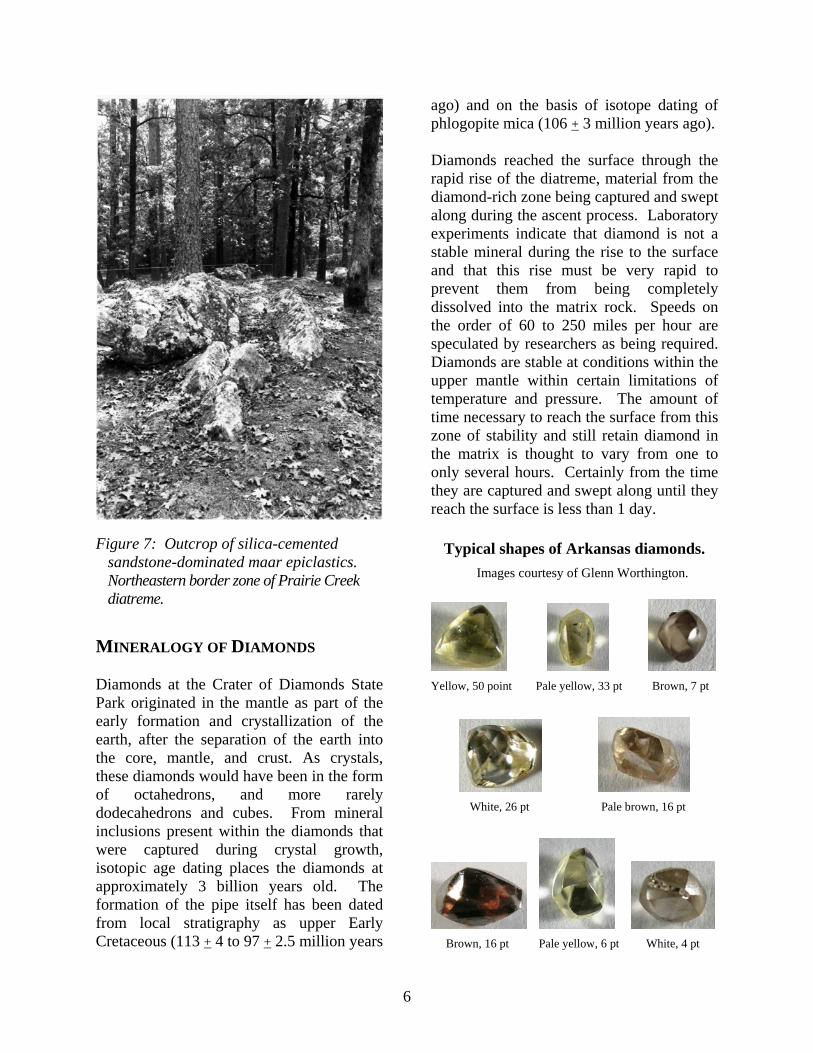
Figure 7: Outcrop of silica-cemented
sandstone-dominated maar epiclastics.
Northeastern border zone of Prairie Creek diatreme.
MINERALOGY OF DIAMONDS Diamonds at the Crater of Diamonds State Park originated in the mantle as part of the early formation and crystallization of the earth, after the separation of the earth into the core, mantle, and crust. As crystals, these diamonds would have been in the form of octahedrons, and more rarely dodecahedrons and cubes. From mineral inclusions present within the diamonds that were captured during crystal growth, isotopic age dating places the diamonds at approximately 3 billion years old. The formation of the pipe itself has been dated from local stratigraphy as upper Early Cretaceous (113 + 4 to 97 + 2.5 million years
ago) and on the basis of isotope dating of phlogopite mica (106 + 3 million years ago). Diamonds reached the surface through the rapid rise of the diatreme, material from the diamond-rich zone being captured and swept along during the ascent process. Laboratory experiments indicate that diamond is not a stable mineral during the rise to the surface and that this rise must be very rapid to prevent them from being completely dissolved into the matrix rock. Speeds on the order of 60 to 250 miles per hour are speculated by researchers as being required. Diamonds are stable at conditions within the upper mantle within certain limitations of temperature and pressure. The amount of time necessary to reach the surface from this zone of stability and still retain diamond in the matrix is thought to vary from one to only several hours. Certainly from the time they are captured and swept along until they reach the surface is less than 1 day.
Typical shapes of Arkansas diamonds.
Images courtesy of Glenn Worthington.
Yellow, 50 point Pale yellow, 33 pt Brown, 7 pt
White, 26 pt Pale brown, 16 pt
Brown, 16 pt Pale yellow, 6 pt White, 4 pt
6

Figure 8 : Diamond dissolution evolution.
(Khokhryakov, A.F., and Pal’yanov, Y.N., 2007) Conditions are not ideal for diamonds during the ascent. At the Park most diamonds have suffered some dissolution by the matrix and transporting fluids, and perhaps even breakage and dissolution effects. Rice grain and flattened shapes are not uncommon and probably represent shards broken from octahedral diamonds and/or resorbed macle twins. The shapes of diamonds recovered from the Park (above) appear on the diamond dissolution evolution chart in the area of 60 to 80 percent weight loss (fig. 8). A significant amount of the deposit’s diamond contained within the host rock has been lost during transport due to dissolution processes. That is significant factor in a commercial venture because there must be a high enough remaining diamond value to be recovered by modern extraction methods to be profitable. The value of mined diamond rough is set by world markets and depends on average size, overall quality, and percentage of gem diamonds to industrial diamonds.
ANSWERS TO FREQUENTLY ASKED QUESTIONS
Definition of Rock Types Definitions of Lamproite/Kimberlite: Klein and Hurlbut (1993), p. 348.
What is Lamproite? Lamproite is a rock name that describes highly potassic and somewhat aluminum-poor igneous rocks with the following range of minerals: phlogopite, a variety of tremolite called richterite, leucite, sanidine, diopside, and a number of rare potassium-, barium-, titanium-, and zirconium-rich oxides and silicates. Leucite and sanidine are not present at the Park. This is a rare type of rock when considering the abundance of all the igneous rocks exposed on the earth’s surface. Lamproites form from partially melted mantle at depths exceeding 93 miles. The rising material is forced to the surface in volcanic pipes, bringing with it xenoliths and xenocryst diamonds from the harzburgitic peridotite or eclogite mantle regions where diamond formation is stabilized. In the instance of the Arkansas lamproites, the diamonds are of eclogite host origin. Eclogite is a rock consisting of red pyrope garnet, green clinopyroxene, and trace minerals, diamond being one. Lamproite intrusions form either champagne- or martini-glass shaped diatreme masses, as well as dikes. What is the difference between lamproite and kimberlite? Kimberlite is a name applied to a group of volatile-rich, mainly carbon dioxide, potassic ultrabasic igneous rocks with a range of visible mineral crystals set in a fine-grained matrix or groundmass. Most of these visible crystals did not form in the groundmass but were captured by it during transport. These crystals may consist of ilmenite, pyrope garnet, olivine, clinopyroxene, phlogopite, enstatite, and chromite. The matrix mineralogy is complex, but may include olivine, phlogopite, perovskite, spinel, and diopside.
7
Kimberlite pipes are the result of explosive diatreme volcanism from very deep mantle derived sources. The theory is that they are formed deep within the mantle, between 93 and 280 miles in depth, from anomalously enriched exotic mantle compositions, and are erupted rapidly and violently, often with considerable CO2 and volatile components. It is this depth of melting and generation which makes kimberlites prone to hosting diamond xenocrysts. Contrast this information to the description of Lamproite, given above. Both kimberlite and lamproite have similar gas driven mechanisms during transport to the surface, however, kimberlites often contain minerals from greater depths than do lamproites. Kimberlite intrusions form carrot-shaped diatreme masses and dikes. When did the names change from peridotite and kimberlite to lamproite and why? Who was responsible for the change? After the discovery of the Argyle pipes in Australia, researchers realized that diamonds were present in a rock that was not kimberlite. So they came back and sampled all the known rocks called kimberlite/peridotite. In 1977, two ladies, B. H. Scott Smith and E. M. W. Skinner, published a paper entitled A New Look at Prairie Creek, Arkansas in a special book on kimberlites and related rocks. In that paper, they proposed the rock name changes based on their detailed work on the minerals present. The new name more accurately describes to geologists the type of rock present at the Prairie Creek diatreme. Scientists in general and geologists in particular are responsible for the name change because they have now accepted the new name and use it instead of the old ones. Science is open to change depending on the discovery of new evidence.
Formation Processes How was the crater formed? Around 100 million years ago, a mass of material moved out of the earth’s mantle at a high rate of speed…30 to 50 miles per hour, driven by carbon dioxide gas. During its journey, it gathered rocks from all the zones of rock it passed through. As it reached the upper crust, the speed increased to as much as 150 miles per hour. When it came near the earth’s surface, about 850 feet below the ground, the pressure of the gas overcame the weight of the overlying sedimentary rock and an explosion occurred. The expanding gas rapidly cooled the mass so we see little heating effects in the surrounding sediments. The resulting explosive volcano is classified as a diatreme by geologists. Where is the volcano now? When you walk out onto the Collecting Area you are actually standing on it! The Prairie Creek diatreme did not form a classic cinder cone shape because it is not that type of volcano, but instead blew out an inverted cone-shaped mass of material, much of which fell back into the site. Erosion has removed about 165 feet of the upper portion of the intrusion since the end of volcanic activity. Evidence from commercial exploration indicates the sides dip toward the center of the 80-acre exposure at about 45 degrees, resembling a martini-glass. How deep is the volcano? The roots of the mass extend into the mantle, to at least 93 miles deep through a very narrow feeder tube, but the largest mass of the volcano is within 660 feet of the earth’s surface. How does a diamond form? In order for diamonds to form, they require extremely high pressures and temperatures which are only found deep in the earth’s
8

mantle. Diamonds are the stable form of carbon at temperatures and pressures that exist there. Under those conditions they crystallize into the cubic form of carbon…diamond. Isotopic age dating of mineral inclusions captured by diamond as it formed implies that diamonds are much older than the age of the intrusion; in fact, some 3 billion years old. This means that they formed long ago in the earth’s history and were brought to the surface much later. Despite the popular belief, diamonds are not forever! They are metastable crystals at the earth’s surface conditions, but have carbon atoms so tightly packed together that without an input of energy, they cannot readily convert to graphite, a more stable form at surface conditions. It is interesting to note that diamonds from the Crater are all well rounded, a testament to the chemically corrosive conditions they encountered during their trip from the upper mantle to the surface. What typically are called crystal faces are actually absorption features, readily recognized by their curved faces and curved lines at face joins. The diamonds have lost approximately 60 to 80 percent of their weight during transport, due to this process. How did the diamonds get here? Although diamond crystals are found in lamproite and related rocks, the origin of diamond is more closely related to the fragments of peridotite and eclogite which are derived from the upper mantle, below cratonic (shield) areas. It is here that the rock, eclogite, forms. Eclogite consists of red pyrope garnet and green clinopyroxene, along with diamond crystals that developed with the garnet and pyroxene crystals. Peridotite fragments (xenoliths) composed of garnet, olivine, and orthopyroxene also
contain diamonds and are similarly derived from the upper mantle. However, both peridotite and eclogite rock fragments commonly come apart during the emplacement process resulting in a matrix containing the disaggregated minerals of olivine, pyroxene, garnet, and diamond (xenocrysts). During the movement of the diatreme from the mantle to the earth’s surface, the diatreme passed through diamond-bearing zones in the mantle. These diamond-bearing rocks, eclogite and peridotite, are captured and swept along with the mass, many of which come apart while being transported. Consequently, many of the minerals present in the lamproite tuffs did not form by normal magmatic processes of crystallization during transportation, but instead are foreign grains. Diamond, garnet, and olivine are examples. Why are the diamonds so small, averaging ¼ carat? Most carbon in the mantle is thought to be in the form of carbonate minerals and diamond, particularly in the upper mantle which has been enriched in carbon by mantle plume or heat transfer processes. Carbon that was available in the rock to crystallize into diamond was not abundant, however, because we are dealing with crystallization processes that took place long before upper mantle enrichment. During crystallization, carbon is removed from the liquid and attached to the orderly structure of the forming diamond. The liquid surrounding a given crystal is therefore depleted in carbon. If this happens under relatively uniform conditions, like a static state, then many small diamonds form rather than a few large diamonds. Also, working against the diamonds being discovered as large crystals is the process of their transportation at a later time to the earth’s surface. The material they are mixed with during their movement is corrosive to the
9

entrained diamond crystals, so if the transport speed is not very fast, the diamonds begin to be resorbed into that material and get smaller and smaller. If transport is too slow, then they disappear, like salt crystals when dissolved in water. At the Crater, diamonds are well rounded due to resorption and have lost a lot of their size. Because diamonds are rare and take some effort to find, discovering even a small one is an exciting experience! Why do diamonds have an oily film on them? They do not! The diamonds at the Park have suffered much on their way to the earth’s surface from the mantle and have lost from 60 to 80 percent of their weight due to chemical removal processes that occurred during transportation. The dissolved surfaces are slick and have an unusual luster that some describe as oily or greasy, but no oil or grease is on them. Geologists use the terms oily or greasy to describe how light reflects from the diamond’s surface, and someone got confused, perhaps thinking that oil was actually on them. What makes a diamond have odd colors? For uncut diamonds, colors are dependent on trace elements that were captured by the diamonds as they formed. Color is influenced by traces of nitrogen in diamond and whether nitrogen is uniformly distributed or present as clumps. Blue diamonds owe their color to traces of boron. White light is composed of all the colors we see in a rainbow and many wavelengths outside our eye’s visible range. What your eye sees as the color of a diamond is due to the fact that the color is reflected while all other colors of the spectrum are absorbed as white light passes through the crystal. For a faceted gem diamond, the colors you see are due to the ability of the diamond’s
crystalline structure to break the light into its colored parts, much as a prism. So we see flashes of red, blue, yellow, green, and orange from the reflected light. Why are these minerals present on the Crater? The suite of minerals present at the Park represents the culmination of many different and varied geologic processes that have acted on the area. Sedimentation and cementation of the sedimentary host rocks, silicification and deposition of silica produced agate and amethyst veins, changing chemistry of the waters also deposited calcite and barite as veins, and the emplacement of the diatreme introduced many new and exotic minerals, diamond being one. Erosion has also been a major player, removing some 165 feet of material and concentrating the heavy resistant minerals in surface soils on the diatreme. How is conglomerate formed? Conglomerate consists of rounded rock pebbles and cobbles, typically cemented by either iron oxides or silica. The beds of gravel from which the conglomerate formed were deposited in one of two environments. Along the 100 million year old coastline, heavy seas winnowed out clay and fine sand from beach deposits, leaving a gravel coastline. As the seas receded or advanced, gravel beds were formed. Cementation by dissolved chemicals in groundwater resulted in beds of conglomerate. These beds originated after the formation and burial of the Prairie Creek diatreme by Late Cretaceous sediments as they are higher up in the stratigraphic section. Also, Quaternary gravel beds were deposited at the base of major river terraces as the rivers meandered across their flood plains, at a higher level that the Little Missouri River is now. These basal gravel layers were locally cemented by groundwater before the terrace
10

was eroded away, thus leaving behind conglomerate masses. The source of the gravel for the Quaternary terrace gravels was both the Ouachita Mountain region and the eroding Cretaceous gravel units just mentioned. Both Cretaceous and Quaternary conglomerates in the area consist predominantly of novaculite, chert, and sandstone along with some minor amount of quartz vein pebbles and cobbles. Search Efforts Can you break up the lamproite breccia and find diamonds? What about the magmatic lamproite? Early after the discovery of the Prairie Creek diatreme, one individual was reported to have done just that, but what he broke up was not hard rock. Instead it was highly weathered material that was essentially soil, but still retained the original breccia rock texture. Nowadays, it is highly unlikely that a visitor would have such luck since the ground has been repeatedly plowed and turned over. As for the magmatic lamproite, diamonds are very rarely reported from soils developed from this rock type, so the odds would be very slim of finding a diamond in the hard matrix rock. Can you find diamonds in the conglomerate? No diamonds to date have been recovered from the conglomerate. The components of the conglomerate originated from the Ouachita Mountains to the north during the time that the pipe was buried by Cretaceous age sediments. Local river terrace gravels during the Quaternary also left behind basal gravel deposits. Conglomerate now present on the surface of the pipe consists of residual masses left behind from gravel deposits that have been eroded away.
Can you find diamonds in the surrounding areas? There are several known smaller pipes on private property to the northeast of the Park. These sites have received a considerable amount of commercial examination over the past 25 years. A few diamonds have been recovered, but access to these properties is denied by the private company that owns them and those individuals and companies holding mineral leases on them. No diamonds have been confirmed as being recovered from other areas adjacent to the Park, such as Quaternary deposits in and adjacent to the Little Missouri River, although rumors to such happenings are often spread. Economic Concerns Why is the site not commercially mined? The Prairie Creek pipe was the first site of commercial diamond mining in North America, but due to financial losses and under capitalization of the operations, those efforts were abandoned. Company exploration in the 1990’s indicated that the deposit was sub-economic for today’s finances, due to too few diamonds to make a commercial venture profitable. However, that does not mean that there is less a chance of finding a diamond than there ever was for visitors. When will the diamonds run out? Statistical information kept by Park personnel since 1972 and studies of this and nearby pipes and the Park’s indicated diamond content implies that at the present rate of recovery by visitors, the Park will continue to have diamonds discovered for at least the next 500 years. And that is for diamonds in just the weathered zone, not counting those present in the unaltered lamproite tuffs.
11
Mineral Identification What is calcite? Calcite is a mineral composed of calcium, carbon, and oxygen. It has a rhombohedral cleavage, is slightly harder than your fingernail, and fizzes when in contact with weak hydrochloric acid. What exactly is jasper and why is it so smooth? Jasper is a fine-grained (cryptocrystalline) variety of the mineral quartz. It may vary in color from red to tan and has a conchoidal fracture. It is smooth because it is hard and has been rounded by transportation in water. What is amethyst and why is it purple? Amethyst is a violet tinted gemstone consisting of crystalline quartz with iron as an added impurity. The iron impurity in amethyst creates another unstable species in the crystal and this new species jumps to an excited state by absorbing a "visible" photon. This species is known as a color center. By absorbing a "visible" photon, it makes the crystal appear colored. The naked eye sees the color as violet. What is mica and why is it shiny? Mica is a group of minerals that have an internal sheet type structure. This structure gives mica a perfect single cleavage direction. It is shiny because the luster on the broken surface of the sheets or plates is brilliant. Phlogopite is the common mica on the pipe. What is the difference between quartz and calcite? Quartz is composed of the elements silicon and oxygen, and is a separate mineral species unrelated to calcite, which is composed of the elements calcium, carbon, and oxygen. Quartz typically has a higher luster, has conchoidal fracture, and is 7 on
the hardness scale. Calcite has a less brilliant luster, has rhombohedral cleavage, is 3 on the hardness scale, and fizzes when in contact with weak hydrochloric acid. What is spinel? Spinel is one of the Spinel Group of minerals that are composed of metals bound with oxygen; in the case of spinel the metals are magnesium and aluminum. Spinel is a common high-temperature mineral in metamorphic rocks and in alumina-rich xenoliths. Another member in the Spinel Group of minerals is the iron aluminum oxide named hercynite. It occurs in some basic and ultrabasic igneous rocks. Spinel and hercynite cannot be distinguished easily as small grains since both are black, have conchoidal fracture, and have a fairly high density. Both are probably present on the collecting area. What is agate and how is it formed? Agate is a banded type of cryptocrystalline chalcedony, a variety of quartz. It forms in layers as a silica gel from silica-laden water and converts to agate as the deposits age. Agate typically displays light and dark banding due to impurities deposited with it. Misconceptions How often do you salt the mine? Despite rumors to the contrary, the site has not been nor is salted by Park personnel. This is a natural deposit and the diamond crystals from this locality have common characteristics that are recognizable to the experienced individual. It is normal that very skeptical individuals will always spread negative information about the diamond-bearing deposit of the Park, perhaps trying to keep other visitors away to increase their own chances of recovering a diamond.
12

13
References and Reading List Bush, W. V., Clardy, B. F., Stone, C. G., and Haley, B. R., 1971, Geologic Map of the
Murfreesboro Quadrangle, Pike and Hempstead Counties, Arkansas: Arkansas Geological Commission Open-File Report, scale 1:24,000.
Dane, C. H., 1929, Upper Cretaceous Formation of Southwestern Arkansas: Arkansas Geological Survey Bull. 1, 215p.
Dunn, D. P., 2002, Xenolith Mineralogy and Geology of the Prairie Creek Lamproite Province, Arkansas – Doctoral Dissertation, University of Texas at Austin, 147 p.
Geostor, 2007, DRG24K (Digital Raster Graphic, 1:24,000, USGS) and DOQ (Digital Orthophoto Quadrangle, natural color, 1 meter pixel resolution) acquired from www.geostor.arkansas.gov.
Hanson, W. D., Clardy, B. F., Stone, C.G., and Haley, B.R., 1998, Geologic Map of the Murfreesboro Quadrangle, Pike and Hempstead Counties, Arkansas: DGM-AR-00611.
Howard, J. M., 1999, Summary of the 1990s Exploration and Testing of the Prairie Creek Diamond-bearing Lamproite Complex, Pike County, Arkansas, with a Field Guide in Contribution to the Geology of Arkansas, Volume IV, AGC MP 18-D, 57-74p.
Howard, J. M., 2006, Arkansas Mineral Commodity Database, In-house data: Arkansas Geological Commission.
Khokhryakov, A.F., and Pal’yanov, Y.N., 2007, The evolution of diamond morphology in the process of dissolution: Experimental data: American Mineralogist, V. 92, No. 5-6, p. 909-917.
Klein, C., and Hurlbut, C.S., Jr., 1993, Manual of Mineralogy, Twenty-First Edition: John Wiley & Sons, Inc., New York, 681 p.
Miser, H. D., and Purdue, A. H., 1919, Gravel Deposits of the DeQueen and Caddo Gap Quadrangles, Arkansas: U.S. Geological Survey, Bulletin 690, 15-29p.
Miser, H. D., and Purdue, A. H., 1929, Geology of the DeQueen and Caddo Gap Quadrangles, Arkansas: U.S. Geological Survey, Bulletin 808, 195p., scale 1:125,000.
Mitchell, R. H., and Bergman, S. C., 1991, Petrology of Lamproites: Plenum Press, New York and London, 447 p.
Morgan, John, 1993, Project Manager’s Report for Phase I – Evaluation program, Crater of Diamonds State Park, Murfreesboro: unpublished file report, Arkansas Department of Parks and Tourism, 77 p.
Morris, E. M., 1987, The Cretaceous Arkansas alkalic province; A summary of petrology and geochemistry in Morris, E. M. and Pasteris, J. D., eds., Mantle Metasomatism and Alkaline Magmatism, The Geological Society of America Special Paper 215, p.217-233.
Pantaleo, N. S., Newton, M. G., Gogineni, S. V., Melton, C. E., and Giardini, A. A., 1979, Mineral inclusions in Arkansas diamonds: Their nature and significance: American Mineralogist, V. 64, p. 1059-1062.
Scott-Skinner, B. H., and Smith, E. M. W., 1984, A new look at Prairie Creek, Arkansas, in Kornprobst, J., ed. Kimberlites I; Kimberlites and related rocks, Amsterdam, Elsevier, p. 255-283.
Wilson, Lionel, and Head III, J.W., 2007, An integrated model of kimberlite ascent and eruption: Nature, V. 447, 5 p.
Worthington, Glenn, 2007, Genuine Diamonds found in Arkansas: Mid-America Prospecting, USA, 178 p.
Zartman, R. E., 1977, Geochronology of some alkalic rock provinces in eastern and central United States: Annual Review, Earth and Planetary Science, V. 5, 257-286p.

Alphabetical Listing of Minerals reported from the Prairie Creek Diatreme and their Geologic Association * Agate – A banded variety of cryptocrystalline quartz; formed by late hydrothermal activity as vein fillings. Almandine – Garnet variety released into the soil by weathering of crustal xenoliths. Amethyst – A variety of crystalline quartz; formed by late hydrothermal activity as veins and pocket fillings within lamproite breccia tuff. Andradite – Garnet variety reported by early worker; possible misidentification. Augite – A pyroxene that is a common constituent of magmatic lamproite. Barite – A barium sulfate present as late hydrothermal veins within tuffaceous rocks. Calcite – Calcium carbonate present as late hydrothermal veins within tuffaceous rocks. Chromite – An oxide that is a constituent of magmatic lamproite; resistant to weathering and often present in soils. Diamond – A constituent of lamproite breccia tuffs and lamproite lapilli tuffs; resistant to weathering and recovered from soils derived by the weathering of these rocks; probably a component of mantle xenoliths. Diopside/Chrome Diopside – A mineral constituent of both magmatic and pyroclastic rock types, consisting of a calcium magnesium silicate. Present as macrocrysts and microphenocrysts. Enstatite – A constituent of magmatic lamproite. Epidote – A constituent of magmatic lamproite; formed during the cooling process. Haggertyite – A rare reaction product within rims of xenoliths. Hydroxylapatite – A phosphate that composes late hydrothermal veins cutting both magmatic and pyroclastic rock types. Generally fine-grained and looks like clay seams. Ilmenite – Present in both magmatic and pyroclastic rock types, the mineral consists of iron titanium oxide. Jasper – A variety of cryptocrystalline quartz; derived from Quaternary river deposits. Jeppeite – A rare reaction product within rims of xenoliths. Kutnohorite (?) – A carbonate reported as an inclusion within lamproite (probable magmatic type). Magnetite – An iron oxide that is a minor constituent of magmatic and pyroclastic rocks. Novaculite – A rock type; a variety of massive microcrystalline quartz, derived from Cretaceous and Quaternary gravels. Olivine – A primary mineral of magmatic and pyroclastic rock types; magnesium iron silicate. Palygorskite – A secondary clay derived from the weathering of magmatic and pyroclastic rock types. Periclase – A constituent of lamproite breccia tuffs; magnesium oxide. Peridot – A gem variety of Olivine; scarce; see Olivine. Perovskite – A minor constituent of magmatic and pyroclastic rocks; calcium titanium oxide. Phlogopite – A mica that is a constituent of lamproite lapilli tuffs and, to a lesser degree, lamproite breccia tuffs; often present in soils derived from these rocks; potassium magnesium aluminum silicate. Priderite – A scarce reaction product in the rims of xenoliths. Pyrope – A garnet type that is a minor constituent of magmatic and pyroclastic rock types. Rock Crystal – A colorless variety of crystalline quartz; secondary veins and pocket fillings in lamproite breccia tuffs; present in soils derived from these rocks. Silicon dioxide. Richerite – An exceptionally rare amphibole that is a constituent of magmatic rocks and contains high fluorine content. Serpentine – A group of silicate minerals formed by the weathering of magmatic and pyroclastic rocks; common soil component in shades of green to blue. Spinel – A magnesium aluminum oxide that is a minor constituent of magmatic and pyroclastic rocks; most abundant in soils derived from these rocks. Topaz – A scarce constituent of crustal xenoliths; aluminum silicate. Tremolite – A calcium magnesium silicate formed by the weathering and alteration of magmatic and pyroclastic rock types.
* compiled from Mineral Species of Arkansas, a Digest, 1987, revision of 2007, AGC Bull. 23.
14


![Arkansas State Police - The Girards Law Firm€¦ · Arkansas State Police 6:05:40 PM] Arkansas State Police Preliminary Fatal](https://img.pdfslide.us/doc/110x75/5b14e6067f8b9a8f548c9f67/arkansas-state-police-the-girards-law-arkansas-state-police-60540-pm-arkansas.jpg)