Embed Size (px)
Citation preview
11.1 Geologic Framework of the Hawaii Islands
11.1.1 Introduction
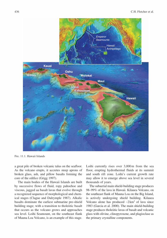
The Hawaii hot spot lies in the mantle under, or just to the south of, the Big Island of Hawaii. Two active subaerial volcanoes and one active submarine volcano reveal its productivity. Centrally located on the Pacific Plate , the hot spot is the source of the Hawaii Island Archipelago and its northern arm, the Emperor Seamount Chain (Fig. 11.1).
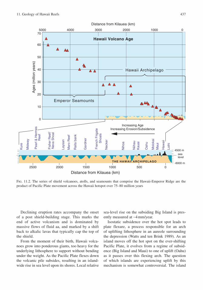
This system of high volcanic islands and asso-ciated reefs, banks, atolls, sandy shoals, and seamounts spans over 30° of latitude across the Central and North Pacific Ocean to the Aleutian Trench, and contains at least 107 separate shield volcanoes (Clague and Dalrymple 1987). The trail of islands increases in age with distance from the hot spot (Fig. 11.2) and reflects the dynamic nature of the Pacific Plate , serving as a record of its speed and direction over the Hawaii hot spot for the last 75–80 MY (Clague and Dalrymple 1987). A major change in plate direction is marked by a northward kink in the chain at the end of the Hawaii Ridge approximately 3,500 km from the site of active volcanism (Moore 1987). On the basis of dredged basalts, Sharp and Clague (2006) assign an age of 50 Ma to this shift from northern to northwestern plate motion, thought to be a result of changes in the movement of neighboring plates to the west. Today the Pacific Plate migrates northwest at a rate of about 10 cm/year (Moore 1987).
The eight main islands in the state: Hawaii, Maui, Kahoolawe , Lanai , Molokai , Oahu , Kauai , and Niihau , make up 99% of the land area of the Hawaii Archipelago. The remainder comprises 124 small volcanic and carbonate islets offshore of the main islands, and to the northwest. Each main island is the top of one or more massive shield volcanoes (named after their long low pro-file like a warriors shield) extending thousands of meters to the seafloor below. Mauna Kea , on the island of Hawaii, stands 4,200 m above sea level and 9,450 m from seafloor to summit, taller than any other mountain on Earth from base to peak. Mauna Loa , the “long” mountain, is the most massive single topographic feature on the planet.
11.1.2 Island Evolution
In traditional lore, the demigod Maui navigated to the Hawaii Islands using an alignment of stano shaped like a fishook. He discovered each island in sequence from oldest to youngest, demonstrating the Hawaii people’s remarkable recognition of the islands’ age gradient.
When an island is born, molten rock pours onto the seafloor , piling upon itself and solidifying under the cooling influence of the surrounding ocean water. Slowly, over hundreds of thousands of years, volcanic rock accumulates and eventually breaches the sea surface to become a high volcanic island. At first, the volcano does not grow as a neat layer-cake of lava beds. Rather, submarine eruptions break into boulders of glass and pyroclastics that accumulate as
11Geology of Hawaii ReefsCharles H. Fletcher, Chris Bochicchio, Chris L. Conger, Mary S. Engels, Eden J. Feirstein, Neil Frazer, Craig R. Glenn, Richard W. Grigg, Eric E. Grossman, Jodi N. Harney, Ebitari Isoun, Colin V. Murray-Wallace, John J. Rooney, Ken H. Rubin, Clark E. Sherman, and Sean Vitousek
B.M. Riegl and R.E. Dodge (eds.), Coral Reefs of the USA, 435© Springer Science + Business Media B.V. 2008
436 C.H. Fletcher et al.
a great pile of broken volcanic talus on the seafloor. As the volcano erupts, it accretes steep aprons of broken glass, ash , and pillow basalts forming the core of the edifice (Grigg 1997).
The main bodies of the Hawaii Islands are built by successive flows of fluid, ropy pahoehoe and viscous, jagged aa basalt lavas that evolve through a recognized sequence of morphological and chem-ical stages (Clague and Dalrymple 1987). Alkalic basalts dominate the earliest submarine pre-shield building stage; with a transition to tholeiitic basalt that occurs as the volcano grows and approaches sea level. Loihi Seamount, on the southeast flank of Mauna Loa Volcano, is an example of this stage.
Loihi currently rises over 3,000 m from the sea floor, erupting hydrothermal fluids at its summit and south rift zone. Loihi’s current growth rate may allow it to emerge above sea level in several thousands of years.
The subaerial main shield-building stage produces 98–99% of the lava in Hawaii. Kilauea Volcano, on the southeast flank of Mauna Loa on the Big Island , is actively undergoing shield building. Kilauea Volcano alone has produced ∼2 km3 of lava since 1983 (Garcia et al. 2000). The main shield-building stage produces tholeiitic lavas of basalt and volcanic glass with olivine , clinopyroxene , and plagioclase as the primary crystalline components.
Maui
Molokai
LanaiKahoolawe
Niihau
Kauai
Oahu
Hawaii
EmperorSeamounts
HawaiiArchipelago
Fig. 11.1. Hawaii Islands
11. Geology of Hawaii Reefs 437
Declining eruption rates accompany the onset of a post shield-building stage. This marks the end of active volcanism and is dominated by massive flows of fluid aa, and marked by a shift back to alkalic lavas that typically cap the top of the shield.
From the moment of their birth, Hawaii volca-noes grow into ponderous giants, too heavy for the underlying lithosphere to support without bending under the weight. As the Pacific Plate flexes down the volcanic pile subsides, resulting in an island-wide rise in sea level upon its shores. Local relative
sea-level rise on the subsiding Big Island is pres-ently measured at ∼4 mm/year.
Isostatic subsidence over the hot spot leads to plate flexure, a process responsible for an arch of uplifting lithosphere in an aureole surrounding the depression (Watts and ten Brink 1989). As an island moves off the hot spot on the ever-shifting Pacific Plate , it evolves from a regime of subsid-ence (Big Island and Maui) to one of uplift (Oahu ) as it passes over this flexing arch. The question of which islands are experiencing uplift by this mechanism is somewhat controversial. The island
0
10
20
30
40
50
60
70010002000300040005000
Distance from Kilauea (km)
Distance from Kilauea (km)
Age
s (m
illio
n ye
ars)
050010002000 15002500
sealevel
-6000 m
4500 m
Fis
her
Ree
f/N
eva
Sho
al
Mar
o R
eef
Rai
ta b
ank
Fre
nch
Frig
ate
Sho
als
Niih
au
Kau
ai
Oah
u
Mol
okai
Mau
i
Haw
aii
Loih
i
Increasing AgeIncreasing Erosion/Subsidence
Nih
oa
Nec
ker
Gar
dner
Lays
an
Mid
way
Kur
e
Pea
rl &
Her
mes
R
eef
Hawaii Volcano Age
THE HAWAII ARCHIPELAGO
Emperor Seamounts
Hawaii Archipelago
Fig. 11.2. The series of shield volcanoes, atolls, and seamounts that comprise the Hawaii-Emperor Ridge are the product of Pacific Plate movement across the Hawaii hotspot over 75–80 million years
438 C.H. Fletcher et al.
of Lanai is thought to be experiencing uplift (Rubin et al. 2000) but the evidence for this (gravel corals) has also been interpreted as the deposit of a large tsunami (Moore and Moore 1984).
Uplift of Oahu is widely conjectured (Muhs and Szabo 1994) and thought to be responsible for the high elevation of fossil coral framestone (in situ reef) such as the Kaena Reef (approximately +24 to +30 m) ca. 532 ka (Szabo et al. 1994) and the Waimanalo Reef (approximately +8.5 m) ca. 125 ka (Moore 1970, 1987; Moore and Campbell 1987; Jones 1994; Szabo et al. 1994; Muhs and Szabo 1994; Grigg and Jones 1997). In their review of Quaternary sea-level evidence, Muhs et al. (2003) describe the age of last interglacial framestone and associated coral gravels on Oahu as consist-ently showing evidence of a long last interglacial epoch. An uplift rate ranging 0.3–0.6 mm/year has been proposed for Oahu (Muhs and Szabo 1994; Muhs et al. 2003) on the basis of emerged fossil coral framestone and gravels. Alternatively, Hearty (2002) contends that the high position of the Kaena limestone is due to a combination of much slower uplift and a higher sea level (∼ +20 m) ca. 400 ka resulting from the “complete disintegration of the Greenland and West Antarctic ice sheets and par-tial melting of the East Antarctic ice sheet during the middle Pleistocene ”.
In some cases, after lying quietly in erosional conditions for thousands to millions of years, Hawaii volcanoes experience a rejuvenation stage of eruption, from a distinctly different magma source. These silica-poor alkalic lavas typically contain combinations of nepheline, olivine , and clinopyroxene with either melilite or plagioclase. Post-erosional rejuvenated eruptions are more explosive than the less viscous eruptions of the shield building stage, commonly producing cinder and tuff cones around active rift zones and vents atop eroding older shields. Three cones on the island of Oahu : Diamond Head , Koko Head, and Koko Crater are the result of this process. Although we have described the classic sequence for Hawaii shields, an individual volcano may become extinct during any of the phases, ending the evolution of that particular volcano (Moore 1987).
Each island represents a cycle of growth and destruction; passing through life’s stages from the youth of volcanic eruption as on the expanding Big Island , to the mature dormancy of an eroding
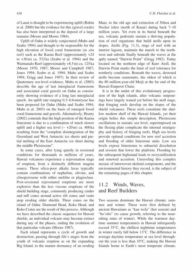
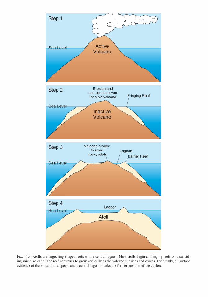
Maui, to the old age and extinction of Nihoa and Necker islets (north of Kauai ) dating back 7–10 million years. Yet even in its burial beneath the sea, volcanic pedestals sustain a thriving popula-tion of reef organisms that build atolls upon its slopes. Atolls (Fig. 11.3), rings of reef with an interior lagoon , maintain the march to the north-west and subside finally beneath the waves at the aptly named “Darwin Point” (Grigg 1982). Today located on the northern edge of Kure Atoll, the Darwin Point marks the limit of reef tolerance for northerly conditions. Beneath the waves, drowned atolls become seamounts, the oldest of which is the 80 million-year-old Meiji at the far end of the Hawaii-Emperor Chain .
It is in the midst of this evolutionary progres-sion of the high islands, after volcanic outpour-ings have largely waned yet before the atoll stage, that fringing reefs develop on the slopes of the shield volcanoes. These reefs constitute the shal-low modern shelf of the Hawaii Islands, yet their origin belies this simple description. Pleistocene oscillations in eustatic sea level, superimposed on the flexing plate complicate the internal stratigra-phy and history of fringing reefs. High sea levels provide optimal conditions for new reef accretion and flooding of older limestone units. Low sea levels expose limestones to subaerial dissolution and erosion that lower the platform. Flooding by the subsequent highstand leads to recrystallization and renewed accretion. Unraveling this complex mosaic of interwoven skeletal components, and the environmental history they record, is the subject of the remaining pages of this chapter.
11.2 Winds, Waves, and Reef Builders
Two seasons dominate the Hawaii climate : sum-mer and winter. These were first defined by ancient Hawaiians as “kau wela” (hot season) and “ho’oilo” (to cause growth, referring to the nour-ishing rains of winter). While the warmest day-time summer temperatures in Hawaii infrequently exceed 35°C, the chilliest nighttime temperatures in winter rarely fall below 13°C. The difference in average daytime temperature at sea level through-out the year is less than 10°C, making the Hawaii Islands home to Earth’s most temperate climate.
Sea Level
InactiveVolcano
Sea Level
Sea Level
AtollSea Level
Step 1
Step 2
Step 3
Step 4
Fringing Reef
Barrier Reef
Lagoon
Lagoon
Volcano eroded to small
rocky islets
ActiveVolcano
Erosion andsubsidence lowerinactive volcano
Fig. 11.3. Atolls are large, ring-shaped reefs with a central lagoon . Most atolls begin as fringing reefs on a subsid-ing shield volcano. The reef continues to grow vertically as the volcano subsides and erodes. Eventually, all surface evidence of the volcano disappears and a central lagoon marks the former position of the caldera
440 C.H. Fletcher et al.
Sea surface temperatures range 24°C in winter to 27°C in summer and salinity is typical of open ocean values (34.5–35‰).
11.2.1 Winds and Rain
Summer extends from May through October, accompanied by the misnamed “gentle” trade winds. On any other shore, consistent 40 km/h winds gusting to 56 km/h are hardly considered gentle and many days, the seas of Hawaii are frothy foam of whitecaps as a result. The trade winds originate with the North Pacific high pressure center usually located to the northeast of the islands. Surface air flows away from this region toward the equator and turns to the southwest. These trade winds approach Hawaii with enduring consistency in the sum-mer and provide constant, natural air-conditioning throughout the season.
Beyond the steady winds and seasonally tran-quil north shore waters, late summer also ushers in threatening tropical depressions that develop in the eastern Pacific. The principle region of tropical storm genesis is an area of trade-wind convergence north of the equator offshore of Central America. Storm systems moving west from these grounds usually pass south of the Big Island , but spawn waves that impact Hawaii shores, and rarely, a sys-tem may curve north to threaten the islands such as hurricanes Iniki in 1992 and Iwa in 1982 (Fletcher et al. 1995).
From October through April, the variable and southerly Kona winds interrupt the persistent trades, bringing the frequent rain and cool, cloudy condi-tions of winter. Kona storms derive their name from the typically sheltered west coast of the Big Island where local southerly winds dominate because of the shadowing effect of the high volcanoes. Occasionally, a Kona storm originating from the south or southwest will stall over Hawaii, bringing persistent, island-wide rain, strong southerly winds and high surf that cause flooding and damage to nearshore ecosystems. These wet events can lead to remarkably dangerous and unpredictable flash flooding in normally tranquil watersheds.
Not only do wind patterns significantly control island weather and microclimates, so do the high shield volcanoes. In areas where onshore trade winds are obstructed by tall mountains, the moist tropical air rises up the mountain slope, cooling on
its ascent and condensing into heavy cloud cover and rainfall on the windward side (Fig. 11.4).
Hawaii’s preeminent example of this orographic rain is Kauai ‘s Mount Waialeale. Famed as one of the wettest spots on Earth, Mount Waialeale rises 1,587 m from the island’s center, and receives a drenching 11.7 m of rain/year. In sharp contrast, the cool, dry air descending down Kauai’s leeward side creates local, semi-arid conditions. Polihale Beach, on the west side of the island receives a mere 20 cm of rain/year. This pattern is similar for most of the islands with the windward side receiving frequent rain squalls, and the leeward side boasting eternal sunshine.
11.2.2 Wave Energy
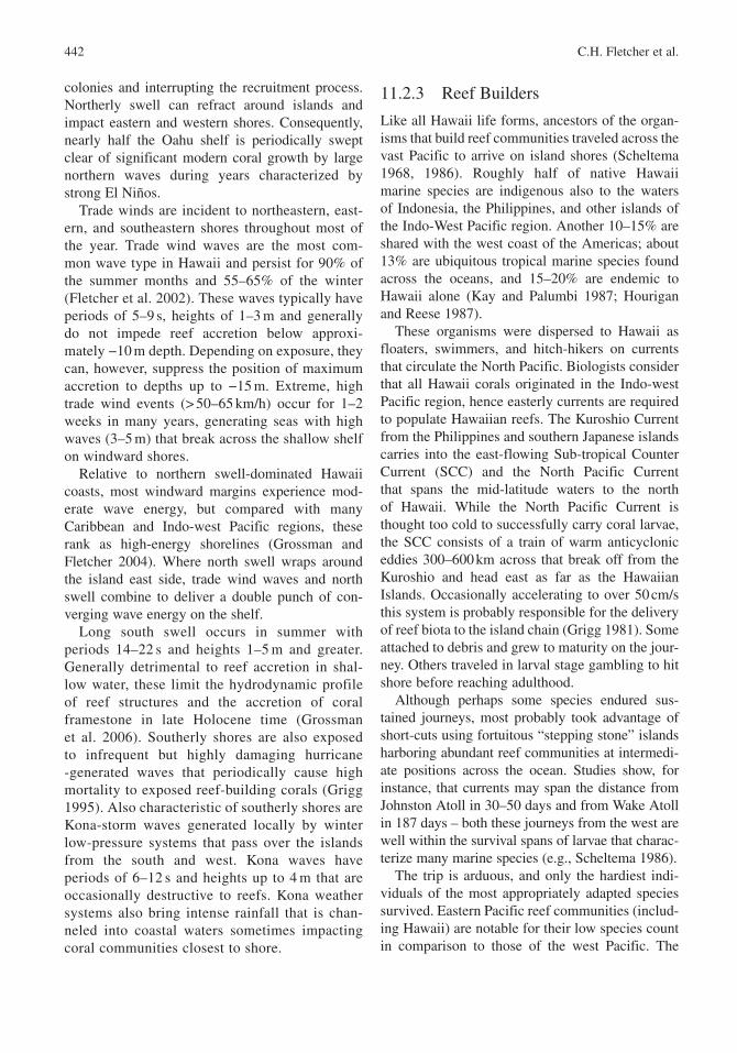
On open exposed coasts, wave energy is the gov-erning factor controlling coral community structure and accretion of in situ framework (Grigg 1998) as well as coral gravels (Grossman and Fletcher 2004). Hawaii is microtidal with an annual range of 0.8 m. Swell wave energy impinges on all shore-lines under a seasonal regime governed by distant storms in the North Pacific (winter) and South Pacific (summer) as well as by systems approach-ing from the south and west (Kona storms ) or any southerly quarter (tropical depressions) in all sea-sons (Moberly et al. 1965; Fig. 11.5).
North Pacific winter swell produces the larg-est and most frequently damaging energy. Yet waves of greatest magnitude and impact are likely to occur only rarely, associated most often with strong El Niño years (e.g., 1998) perhaps a decade or more apart (Rooney et al. 2004). Intervening coral growth able to survive the strong annual pounding by waves are often wiped out by these interannual waves of extraordinary size and energy. Hence, modern framework in exposed settings is suppressed to a veneer (Grigg 1998) and, according to radiocarbon dates of fos-sil corals, has been continually suppressed since ca. 5 ka on northerly exposed coasts (Rooney et al. 2004) and ca. 3 ka on southern shorelines (Grossman et al. 2006).
Typical north shore annual waves have periods of 14–20 s and breaking face heights of 2–15 m. Waves of this magnitude are able to generate and transport a coarse bedload of carbonate gravel that scours and abrades the reef surface toppling living
11. Geology of Hawaii Reefs 441
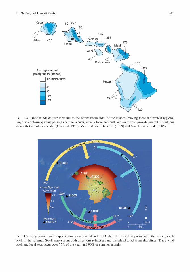
Fig. 11.4. Trade winds deliver moisture to the northeastern sides of the islands, making these the wettest regions. Large-scale storm systems passing near the islands, usually from the south and southwest, provide rainfall to southern shores that are otherwise dry (Oki et al. 1999). Modified from Oki et al. (1999) and Giambelluca et al. (1986)
Fig. 11.5. Long period swell impacts coral growth on all sides of Oahu . North swell is prevalent in the winter, south swell in the summer. Swell waves from both directions refract around the island to adjacent shorelines. Trade wind swell and local seas occur over 75% of the year, and 90% of summer months
Molokai
Lanai
Kahoolawe
Niihau
Kauai
Oahu
Hawaii
Maui
155
155
275
275
435355
236
120
160
80
40
80
120
160
80
40
insufficient data
Average annual precipitation (inches)
442 C.H. Fletcher et al.
colonies and interrupting the recruitment process. Northerly swell can refract around islands and impact eastern and western shores. Consequently, nearly half the Oahu shelf is periodically swept clear of significant modern coral growth by large northern waves during years characterized by strong El Niños.
Trade winds are incident to northeastern, east-ern, and southeastern shores throughout most of the year. Trade wind waves are the most com-mon wave type in Hawaii and persist for 90% of the summer months and 55–65% of the winter (Fletcher et al. 2002). These waves typically have periods of 5–9 s, heights of 1–3 m and generally do not impede reef accretion below approxi-mately −10 m depth. Depending on exposure, they can, however, suppress the position of maximum accretion to depths up to −15 m. Extreme, high trade wind events (> 50–65 km/h) occur for 1–2 weeks in many years, generating seas with high waves (3–5 m) that break across the shallow shelf on windward shores.
Relative to northern swell -dominated Hawaii coasts, most windward margins experience mod-erate wave energy , but compared with many Caribbean and Indo-west Pacific regions, these rank as high-energy shorelines (Grossman and Fletcher 2004). Where north swell wraps around the island east side, trade wind waves and north swell combine to deliver a double punch of con-verging wave energy on the shelf.
Long south swell occurs in summer with periods 14–22 s and heights 1–5 m and greater. Generally detrimental to reef accretion in shal-low water, these limit the hydrodynamic profile of reef structures and the accretion of coral framestone in late Holocene time (Grossman et al. 2006). Southerly shores are also exposed to infrequent but highly damaging hurricane -generated waves that periodically cause high mortality to exposed reef-building corals (Grigg 1995). Also characteristic of southerly shores are Kona-storm waves generated locally by winter low-pressure systems that pass over the islands from the south and west. Kona waves have periods of 6–12 s and heights up to 4 m that are occasionally destructive to reefs. Kona weather systems also bring intense rainfall that is chan-neled into coastal waters sometimes impacting coral communities closest to shore.
11.2.3 Reef Builders
Like all Hawaii life forms, ancestors of the organ-isms that build reef communities traveled across the vast Pacific to arrive on island shores (Scheltema 1968, 1986). Roughly half of native Hawaii marine species are indigenous also to the waters of Indonesia, the Philippines , and other islands of the Indo-West Pacific region. Another 10–15% are shared with the west coast of the Americas; about 13% are ubiquitous tropical marine species found across the oceans, and 15–20% are endemic to Hawaii alone (Kay and Palumbi 1987; Hourigan and Reese 1987).
These organisms were dispersed to Hawaii as floaters, swimmers, and hitch-hikers on currents that circulate the North Pacific . Biologists consider that all Hawaii corals originated in the Indo-west Pacific region, hence easterly currents are required to populate Hawaiian reefs. The Kuroshio Current from the Philippines and southern Japanese islands carries into the east-flowing Sub-tropical Counter Current (SCC) and the North Pacific Current that spans the mid-latitude waters to the north of Hawaii. While the North Pacific Current is thought too cold to successfully carry coral larvae , the SCC consists of a train of warm anticyclonic eddies 300–600 km across that break off from the Kuroshio and head east as far as the Hawaiian Islands . Occasionally accelerating to over 50 cm/s this system is probably responsible for the delivery of reef biota to the island chain (Grigg 1981). Some attached to debris and grew to maturity on the jour-ney. Others traveled in larval stage gambling to hit shore before reaching adulthood.
Although perhaps some species endured sus-tained journeys, most probably took advantage of short-cuts using fortuitous “stepping stone” islands harboring abundant reef communities at intermedi-ate positions across the ocean. Studies show, for instance, that currents may span the distance from Johnston Atoll in 30–50 days and from Wake Atoll in 187 days – both these journeys from the west are well within the survival spans of larvae that charac-terize many marine species (e.g., Scheltema 1986).
The trip is arduous, and only the hardiest indi-viduals of the most appropriately adapted species survived. Eastern Pacific reef communities (includ-ing Hawaii) are notable for their low species count in comparison to those of the west Pacific. The
11. Geology of Hawaii Reefs 443
numbers of marine types steadily decrease along an eastwardly extending line. This biotic attenuation marks a natural filter ensuring that those arriving in Hawaii waters, and able to secure a safe position within the ecology, are winners of a survival lottery in which a great many organisms begin the journey but only those with great luck, fortitude, and the appropriate set of physical attributes complete it.
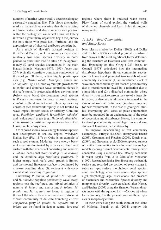
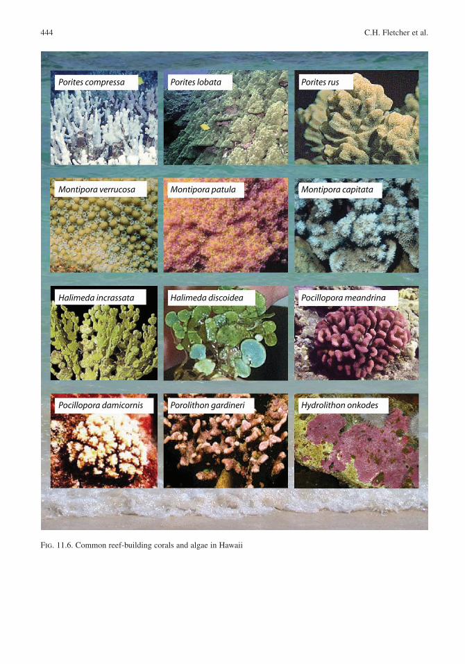
As a result of Hawaii’s isolated position in the Central Pacific, reef communities experience relatively low coral species diversity in com-parison to other Indo-Pacific sites. Of the approxi-mately 57 coral species documented in the main Hawaii Islands (Maragos 1977, 1995), fewer than 25% typically constitute dominant components of the ecology. Of these, a few highly plastic spe-cies (e.g., Porites lobata, Montipora patula and M. capitata; Fig. 11.6) employ multiple growth forms to exploit and dominate wave-controlled niches in the reef system. In protected and deep environments (below wave base) the dominant coral species is Porites compressa. In more exposed settings, P. lobata is the dominant coral. These species may construct reef framework rapidly if not limited by wave impact, bottom scour, or turbidity . Coralline (e.g., Porolithon gardineri, Hydrolithon onkodes) and “calcareous” algae (e.g., Halimeda discoidea, H. incrassata) constitute important members of all Hawaii reefal ecosystems.
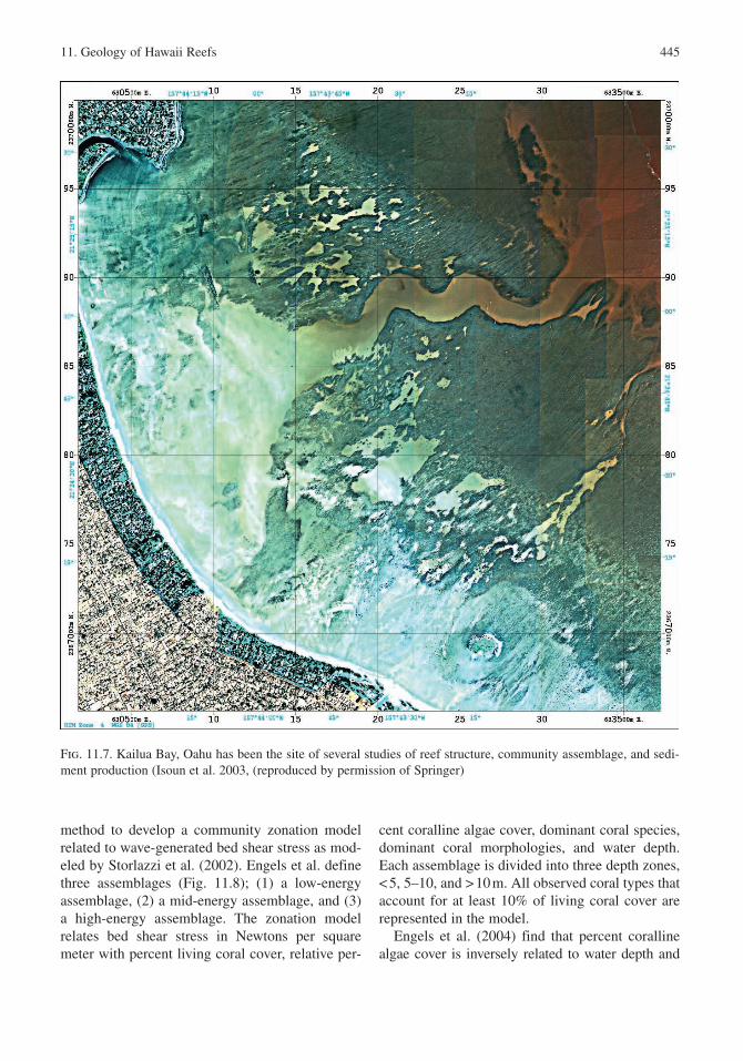
On exposed shores, wave energy tends to suppress reef development in shallow depths. Windward Kailua Bay (Fig. 11.7) on Oahu is an example of such a reef system. Moderate wave energy back-reef areas are dominated by an abraded fossil reef surface with thin veneers of encrusting and massive P. lobata, occasional stout Pocillopora meandrina and the coralline alga Porolithon gardineri. In higher energy back-reefs, coral growth is limited and the skeletal limestone surface is dominated by crustose coralline algae (H. onkodes) with occa-sional stout branching P. gardineri.
Encrusting P. lobata, M. patula, M. capitata, and H. onkodes populate persistently wave-swept regions near the reef crest and mixed colonies of massive P. lobata and encrusting P. lobata, M. patula, and M. capitata are found in regions of the reef flat where there is reduced wave stress. A vibrant community of delicate branching Porites compressa, platy M. patula, M. capitata and P. lobata can be found in deeper central fore-reef
regions where there is reduced wave stress. Platy forms of coral exploit the vertical walls of drowned channels and karst holes throughout many reefs.
11.2.3.1 Reef Communities and Shear Stress
Now classic studies by Dollar (1982) and Dollar and Tribble (1993) identified physical disturbance from waves as the most significant factor determin-ing the structure of Hawaiian coral reef communi-ties . Expanding on this, Grigg (1983) based on Connell (1978) articulated how the intermediate disturbance hypothesis fit on community succes-sion in Hawaii and presented two models of coral community succession: (1) an undisturbed (lack of wave impact) community that reaches peak diversity due to recruitment followed by a reduction due to competition and (2) a disturbed community where diversity is set back to zero in the case of a large dis-turbance, or diversity is ultimately increased in the case of intermediate disturbance (substrate is opened for new recruitment). In the case of geological stud-ies, interpreting drill cores of paleo-communities must be grounded in an understanding of the roles of succession and disturbance. Hence, it is common to develop community assemblage models during studies of Hawaiian reef stratigraphy .
To improve understanding of reef community assemblage , Harney et al. (2000), Harney and Fletcher (2003), Grossman and Fletcher (2004), Engels et al. (2004), and Grossman et al. (2006) employed surveys of benthic communities to develop coral assemblage models marking distinct environments. Surveys were conducted using a modified line-intercept technique in water depths from 2 to 25 m after Montebon (1992). Researchers laid a 10 m line along the benthic surface and recorded the position of every change in substrate type, surface morphology , coral species, coral morphology, coral associations, algal species, algal morphology, algal associations, and presence of bioeroders and zooanthids . Species diversity and morphologic diversity were calculated after Harney and Fletcher (2003) using the Shannon-Weaver diver-sity index with the equation Hc = −Σπ (log π) where Hc is diversity, π is the present cover on the ith spe-cies or morphologic form.
In their work along the south shore of the island of Molokai , Engels et al. (2004) employ this
444 C.H. Fletcher et al.
Porites compressa Porites lobata Porites rus
Montipora verrucosa Montipora patula Montipora capitata
Pocillopora meandrina
Pocillopora damicornis Porolithon gardineri
Halimeda incrassata
Hydrolithon onkodes
Halimeda discoidea
Fig. 11.6. Common reef-building corals and algae in Hawaii
11. Geology of Hawaii Reefs 445
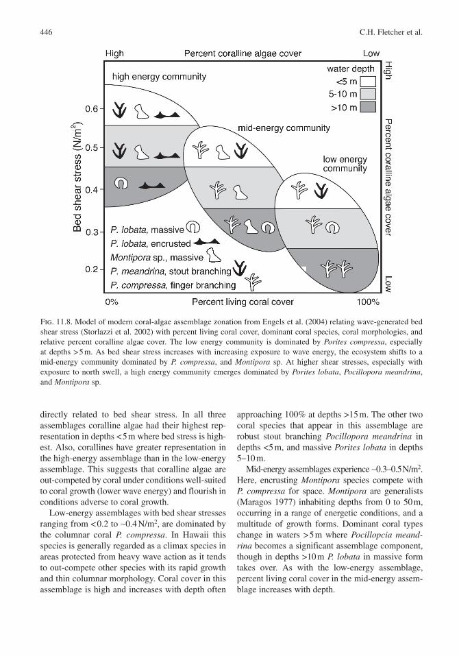
method to develop a community zonation model related to wave-generated bed shear stress as mod-eled by Storlazzi et al. (2002). Engels et al. define three assemblages (Fig. 11.8); (1) a low-energy assemblage , (2) a mid-energy assemblage, and (3) a high-energy assemblage. The zonation model relates bed shear stress in Newtons per square meter with percent living coral cover, relative per-
cent coralline algae cover, dominant coral species, dominant coral morphologies, and water depth. Each assemblage is divided into three depth zones, < 5, 5–10, and > 10 m. All observed coral types that account for at least 10% of living coral cover are represented in the model.
Engels et al. (2004) find that percent coralline algae cover is inversely related to water depth and
Fig. 11.7. Kailua Bay, Oahu has been the site of several studies of reef structure, community assemblage , and sedi-ment production (Isoun et al. 2003, (reproduced by permission of Springer)
446 C.H. Fletcher et al.
Fig. 11.8. Model of modern coral-algae assemblage zonation from Engels et al. (2004) relating wave-generated bed shear stress (Storlazzi et al. 2002) with percent living coral cover, dominant coral species, coral morphologies, and relative percent coralline algae cover. The low energy community is dominated by Porites compressa, especially at depths > 5 m. As bed shear stress increases with increasing exposure to wave energy , the ecosystem shifts to a mid-energy community dominated by P. compressa, and Montipora sp. At higher shear stresses, especially with exposure to north swell , a high energy community emerges dominated by Porites lobata, Pocillopora meandrina, and Montipora sp.
directly related to bed shear stress . In all three assemblages coralline algae had their highest rep-resentation in depths < 5 m where bed stress is high-est. Also, corallines have greater representation in the high-energy assemblage than in the low-energy assemblage. This suggests that coralline algae are out-competed by coral under conditions well-suited to coral growth (lower wave energy ) and flourish in conditions adverse to coral growth.
Low-energy assemblages with bed shear stresses ranging from < 0.2 to ∼0.4 N/m2, are dominated by the columnar coral P. compressa. In Hawaii this species is generally regarded as a climax species in areas protected from heavy wave action as it tends to out-compete other species with its rapid growth and thin columnar morphology . Coral cover in this assemblage is high and increases with depth often
approaching 100% at depths >15 m. The other two coral species that appear in this assemblage are robust stout branching Pocillopora meandrina in depths <5 m, and massive Porites lobata in depths 5–10 m.
Mid-energy assemblages experience ∼0.3–0.5 N/m2. Here, encrusting Montipora species compete with P. compressa for space. Montipora are generalists (Maragos 1977) inhabiting depths from 0 to 50 m, occurring in a range of energetic conditions, and a multitude of growth forms. Dominant coral types change in waters > 5 m where Pocillopcia meand-rina becomes a significant assemblage component, though in depths >10 m P. lobata in massive form takes over. As with the low-energy assemblage, percent living coral cover in the mid-energy assem-blage increases with depth.
11. Geology of Hawaii Reefs 447
The high-energy assemblage experiences bed shear stresses from ∼0.4 to over 0.6 N/m2. Fragile branching P. compressa disappears completely from the dominant corals and is replaced by Montipora sp., Poc. meandrina, and encrusting forms of P. lobata. At depths >10 m, P. lobata in encrusting and massive forms take over as the dominant coral as Montipora sp., and Poc. meand-rina diminish. This assemblage is characterized by low living coral cover and, unlike low-energy and mid-energy assemblages, coral growth is optimized between 5 and 10 m water depth where a balance between encrusting/stout morphology , shear stress , and ambient light are achieved.
It is worth noting that the high-energy assem-blage modeled by Engels et al. (2004) lives on skeletal limestone (fossil reef) radiocarbon dated ca. 5 ka. This suggests an absence of net accretion since mid-Holocene time where reef is exposed to north swell . We infer that survey data supporting the model represent a community that is periodi-cally interrupted by high energy events that clear the substrate of living community. Hence, we con-
ceive of an “extreme-energy assemblage” consist-ing of temporally restricted living coral and algae on an antecedent seafloor , as described by Rooney et al. (2004) and Grossman et al. (2006). We return to this issue later in the chapter.
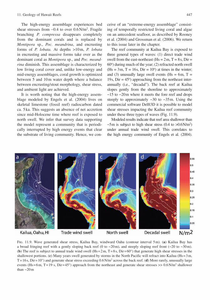
The reef community at Kailua Bay is exposed to three general types of waves: (1) direct trade wind swell from the east-northeast (Hs = 2 m, T = 8 s, Dir = 60o) during much of the year; (2) refracted north swell (Hs = 3 m, T = 16 s, Dir = 10o) at times in the winter; and (3) unusually large swell events (Hs = 6 m, T = 19 s, Dir = 45o) approaching from the northeast inter-annually (i.e., “decadal”). The back reef at Kailua slopes gently from the shoreline to approximately −15 to −20 m where it meets the fore reef and drops steeply to approximately −30 to −35 m. Using the commercial software Delft3D it is possible to model shear stresses impacting the Kailua reef community under these three types of waves (Fig. 11.9).
Modeled results indicate that reef area shallower than −5 m is subject to high shear stress (0.4 to >0.6 N/m2) under annual trade wind swell . This correlates to the high energy community of Engels et al. (2004).
Fig. 11.9. Wave generated shear stress , Kailua Bay, windward Oahu (contour interval 5 m). (a) Kailua Bay has a broad fringing reef with a gently sloping back reef (0 to −20 m), and steeply sloping reef front (−20 to −30 m). (b) The reef is subject to annual trade wind swell (Hs = 2 m, T = 8 s, Dir = 60°) that generate high shear stresses in the shallowest portions. (c) Many years swell generated by storms in the North Pacific will refract into Kailua (Hs = 3 m, T = 16 s, Dir = 10°) and generate shear stress exceeding 0.6 N/m2 across the back reef. (d) More rarely, unusually large events (Hs = 6 m, T = 19 s, Dir = 45°) approach from the northeast and generate shear stresses >> 0.6 N/m2 shallower than −20 m
448 C.H. Fletcher et al.
However, deeper than −5 m, bed stress ranges from 0.15 to < 0.05 N/m2 suggesting that a low energy com-munity should be stable across most of the reef surface under typical trade swell. However, in most years north swell refracts into Kailua , generating shear stress exceeding 0.6 N/m2 across broad areas of the back reef. This suppresses the depth of framework accretion to −10 m or more, leaving shallower areas devoid of long-term coral cover. Extreme energy also occurs on a low frequency, interannual basis (i.e., decadal) generating damaging stresses across the entire back reef and into depths of −20 to −25 m. Presumably, it is these events that have suppressed widespread Holocene accretion since ca. 5 ka (Grossman and Fletcher 2004; Rooney et al. 2004). Localized sheltering and deeper topography experience stress levels below 0.5 N/m2 and framework accretion continues despite the wave environment.
Careful collection of reef community survey data recording percent coral and algal coverage, diversity, and substrate type are needed to verify community response to these model results. Until then, the rela-tionship between modeled shear stress and reef com-munity organization constitute a testable hypothesis.
11.3 Physical Characteristics of the Oahu Shelf
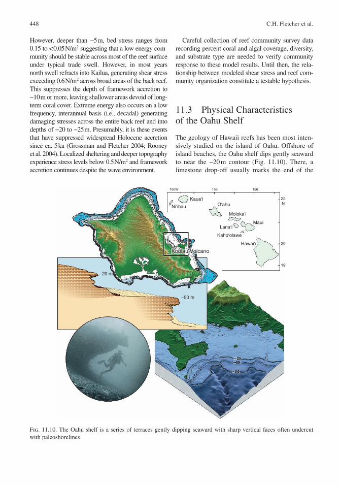
The geology of Hawaii reefs has been most inten-sively studied on the island of Oahu . Offshore of island beaches, the Oahu shelf dips gently seaward to near the −20 m contour (Fig. 11.10). There, a limestone drop-off usually marks the end of the
Fig. 11.10. The Oahu shelf is a series of terraces gently dipping seaward with sharp vertical faces often undercut with paleoshorelines
−20 m
−50 m
20406080
100
20 40 60 80
100
40
20
Koolau Volcano
Moloka‘i
Lana‘i
Kaho‘olawe
Ni‘ihau
Kaua‘iO‘ahu
Maui
Hawai‘i
22N
20
19
158 156160W
11. Geology of Hawaii Reefs 449
shelf. The base of this wall typically occurs near −30 m depth where a deeper, usually sand-covered terrace extends seaward to approximately −50 m. Below −50 m a second wall and third terrace are found (Fletcher and Sherman 1995).
11.3.1 General Bathymetry
The Oahu shelf is swept by large swells that generate high shear stress limiting modern reef development . But in the past, reef accretion was apparently more widespread because this shelf is almost entirely built of Pleistocene skeletal limestone sequences where it has not been interrupted by volcanic activity. A major problem driving scientific research among paleoreef workers in Hawaii has been the question how and when and under what conditions such mas-sive fossil reefs could develop despite the fact that little modern reef accretion was occurring.
A mosaic of paleoreefs that comprise the island shelf has been worked out by researchers and is
presented in a later section. Because shelf con-struction spans three interglacial periods and two glacial periods, karstification , recrystallization, cementation, and accretion have all left their mark and added geologic components to the limestone mosaic. As discussed below, these geologic fea-tures are evident in the bathymetry , rugosity, nature of sand fields, and pattern of reef development .
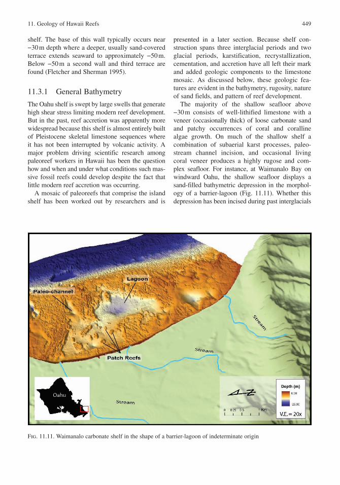
The majority of the shallow seafloor above −30 m consists of well-lithified limestone with a veneer (occasionally thick) of loose carbonate sand and patchy occurrences of coral and coralline algae growth. On much of the shallow shelf a combination of subaerial karst processes, paleo-stream channel incision, and occasional living coral veneer produces a highly rugose and com-plex seafloor. For instance, at Waimanalo Bay on windward Oahu , the shallow seafloor displays a sand-filled bathymetric depression in the morphol-ogy of a barrier-lagoon (Fig. 11.11). Whether this depression has been incised during past interglacials
Fig. 11.11. Waimanalo carbonate shelf in the shape of a barrier-lagoon of indeterminate origin
450 C.H. Fletcher et al.
wherein the shelf was exposed to meteoric waters leaving paleo-channel, karst, and doline type depressions (Purdy 1974) or it is the product of Holocene framework growth, or a combination, can only be determined by dating and interpreting surrounding components. Depressions such as these are a common feature on Hawaii carbonate shelves (Stearns 1974); in Waimanalo Bay they range in size from < 5 to ∼2,700 m2 and are visible to depths of −40 m, and are likely found deeper. Sediment fills a majority of these features burying a 2–3 m wall as well as circular to oval shaped paleo-patch reefs. In Fig. 11.11 the sediment fill of the depres-sion has been removed in order to display the ante-cedent topography .
The seaward edge of the Oahu shelf is marked by a wall that drops to depths of −30 m or more. In many areas a prominent erosional notch marks the face of the wall at approximately −18 to −25 m. Because it is clearly a former intertidal feature, Stearns (1974) named the notch the “Kaneohe Shoreline ” and proposed that it formed in late Pleistocene time ca. 80 ka. Figure 11.10 shows a researcher SCUBA diving within the Kaneohe Shoreline.
Where living corals aggregate on the seaward slope of the shelf (e.g., Kailua Bay), the Kaneohe Shoreline is obscured by Holocene accretion. At such locations the shelf edge marks the top of the fore-reef and the Kaneohe Shoreline likely under-lies modern fore-reef growth. Hence, modern reef morphology is strongly governed by the antecedent geometry of the seafloor .
The second terrace (> −30 m depth) is covered in an extensive fore-reef sediment wedge that has been studied by Hampton et al. (2003) and Grossman et al. (2006). These sands are inferred to be Holocene in age, and found in seaward sloping, low-gradient deposits reaching thicknesses over tens of meters. The patchy nature of coral framework accretion around the island, and the strong development of these sediment wedges, led Grossman et al. (2006) to conclude that the Holocene is the first significant epoch in late Quaternary time where sediment pro-duction and offshore progradation are increasingly important shelf constructional processes.
Given the dominance of antecedent topogra-phy , seismic surveys are especially important in revealing surficial and subsurface aspects of the shallow shelf.
11.3.2 Acoustic Facies
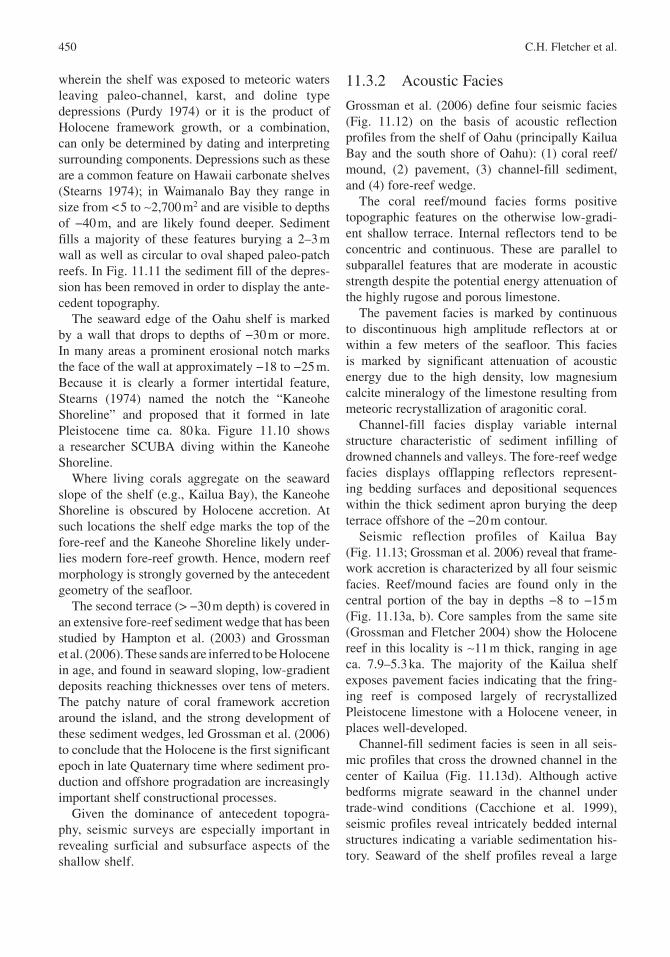
Grossman et al. (2006) define four seismic facies (Fig. 11.12) on the basis of acoustic reflection profiles from the shelf of Oahu (principally Kailua Bay and the south shore of Oahu): (1) coral reef/mound, (2) pavement, (3) channel-fill sediment , and (4) fore-reef wedge.
The coral reef/mound facies forms positive topographic features on the otherwise low-gradi-ent shallow terrace. Internal reflectors tend to be concentric and continuous. These are parallel to subparallel features that are moderate in acoustic strength despite the potential energy attenuation of the highly rugose and porous limestone.
The pavement facies is marked by continuous to discontinuous high amplitude reflectors at or within a few meters of the seafloor . This facies is marked by significant attenuation of acoustic energy due to the high density, low magnesium calcite mineralogy of the limestone resulting from meteoric recrystallization of aragonitic coral.
Channel-fill facies display variable internal structure characteristic of sediment infilling of drowned channels and valleys. The fore-reef wedge facies displays offlapping reflectors represent-ing bedding surfaces and depositional sequences within the thick sediment apron burying the deep terrace offshore of the −20 m contour.
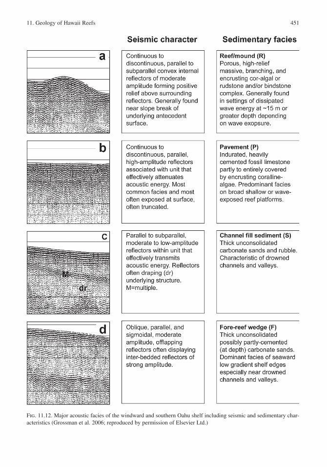
Seismic reflection profiles of Kailua Bay (Fig. 11.13; Grossman et al. 2006) reveal that frame-work accretion is characterized by all four seismic facies . Reef/mound facies are found only in the central portion of the bay in depths −8 to −15 m (Fig. 11.13a, b). Core samples from the same site (Grossman and Fletcher 2004) show the Holocene reef in this locality is ∼11 m thick, ranging in age ca. 7.9–5.3 ka. The majority of the Kailua shelf exposes pavement facies indicating that the fring-ing reef is composed largely of recrystallized Pleistocene limestone with a Holocene veneer, in places well-developed.
Channel-fill sediment facies is seen in all seis-mic profiles that cross the drowned channel in the center of Kailua (Fig. 11.13d). Although active bedforms migrate seaward in the channel under trade-wind conditions (Cacchione et al. 1999), seismic profiles reveal intricately bedded internal structures indicating a variable sedimentation his-tory. Seaward of the shelf profiles reveal a large
11. Geology of Hawaii Reefs 451
Fig. 11.12. Major acoustic facies of the windward and southern Oahu shelf including seismic and sedimentary char-acteristics (Grossman et al. 2006; reproduced by permission of Elsevier Ltd.)
452 C.H. Fletcher et al.
Fig. 11.13. Seismic reflection profiles of the Kailua Bay shelf (Grossman et al. 2006; reproduced by permission of Elsevier Ltd.) showing both uninterpreted (left) and interpreted (right) sections. Drill core sites (triangles) are shown with radiometric age results (Grossman and Fletcher 2004), acoustic multiples (M), line crossings (crosses), reef facies (R), pavement facies (P), channel fill sediment facies (S), and fore-reef wedge facies (F)
sediment wedge with internal structures charac-teristic of interbedded sediment/rubble units. The deposit has a thickness reaching ∼40 m and its age is unclear. Lack of major internal reflectors suggest that subaerial exposure, as would have occurred at the last glacial maximum , did not produce a dis-tinct horizon, or the unit has largely accumulated during Holocene time.
11.3.3 Shelf Substrate
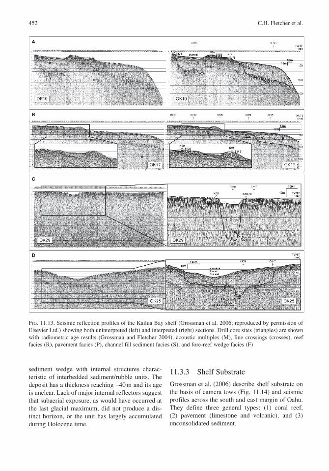
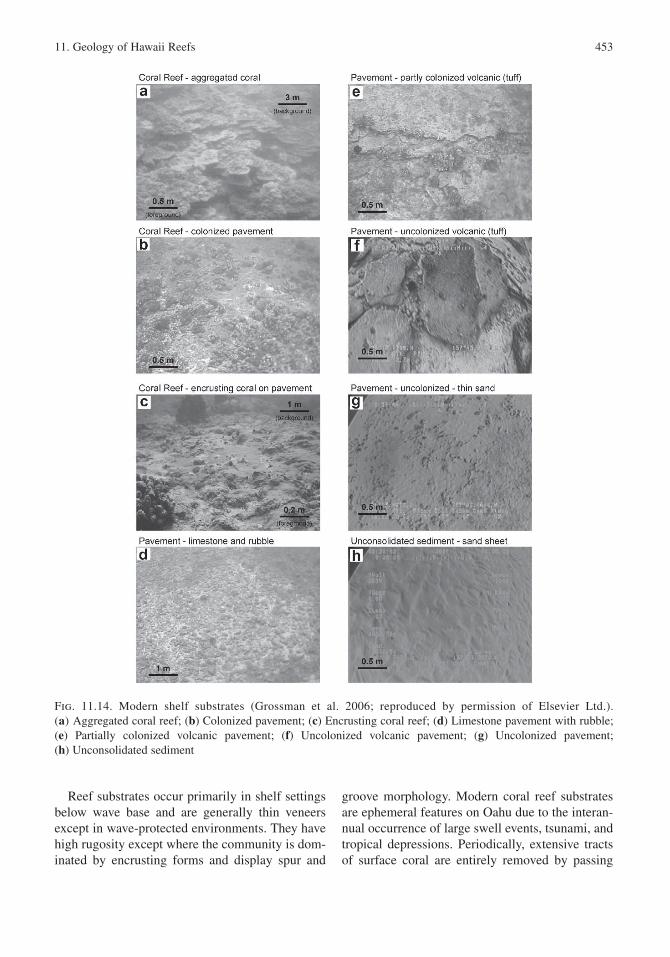
Grossman et al. (2006) describe shelf substrate on the basis of camera tows (Fig. 11.14) and seismic profiles across the south and east margin of Oahu . They define three general types: (1) coral reef, (2) pavement (limestone and volcanic), and (3) unconsolidated sediment .
11. Geology of Hawaii Reefs 453
Reef substrates occur primarily in shelf settings below wave base and are generally thin veneers except in wave-protected environments. They have high rugosity except where the community is dom-inated by encrusting forms and display spur and
groove morphology . Modern coral reef substrates are ephemeral features on Oahu due to the interan-nual occurrence of large swell events, tsunami , and tropical depressions. Periodically, extensive tracts of surface coral are entirely removed by passing
Fig. 11.14. Modern shelf substrates (Grossman et al. 2006; reproduced by permission of Elsevier Ltd.). (a) Aggregated coral reef; (b) Colonized pavement; (c) Encrusting coral reef; (d) Limestone pavement with rubble ; (e) Partially colonized volcanic pavement; (f) Uncolonized volcanic pavement; (g) Uncolonized pavement; (h) Unconsolidated sediment
454 C.H. Fletcher et al.
hurricanes and high waves (Dollar and Tribble 1993; Grigg 1995, 1998).
Pavement substrates occur between 0 and −120 m depth and are low-gradient surfaces comprised of fossil reef limestone or volcanic basalts. Volcanic pavements commonly display locally high rugos-ity in the form of ledges, pedestals, and meter-size plates or boulders, whereas limestone pavements are often of low relief. The age of volcanic pave-ments is poorly known, while limestone pavement ages range ca. 5–210 ka (Sherman et al. 1999; Grossman and Fletcher 2004; Rooney et al. 2004).
Unconsolidated sediments are primarily marine carbonate sands found in channels and fields across the inner and middle shelf (Harney et al. 2000; Harney and Fletcher 2003; Conger 2005). Sands are also common along the outer shelf in the form of thick sediment deposits (Hampton et al. 2003) often supporting stands of the green calcareous alga Halimeda (Harney et al. 2000).
Variations to this simple classification result from the temporal colonization of these substrates by coral and algae (coralline and fleshy green and brown algae). Other substrates including volcanic boulder fields are known along portions of the south Oahu shelf (Makapuu Pt.) that have not been studied.
Sandy nearshore substrate is important as a sand and gravel resource, habitat, and dynamic region of the bathymetry and hence worthy of further discussion.
11.3.3.1 Sand Fields
Conger (2005) investigated shallow, reef flat sand fields on the Oahu shelf and analyzed their geom-etry and relationship to depth. Sand deposits, and their distribution on fringing reefs have a signifi-cant effect on shoreline stability and the geologic framework of the coastal zone. For these reasons it is important to improve understanding of sand storage in shallow water.
Most shelf sands are carbonate with only a small percentage of terrigenous content (Moberly et al. 1965; Harney et al. 2000; Harney and Fletcher 2003). These biogenic sands accumulate in relatively thin patches, fields, and linear deposits perched on the shallow shelf. Their presence results from a state of semi-equilibrium among various processes controlling the sand budget including biologic production, temporary and permanent
storage, and loss (including abrasion, dissolution, bioerosion , and offshore transport). A combination of wave energy , water quality , biologic productiv-ity, and storage space all control creation, destruc-tion, and storage of carbonate sands. Changes in sea level mean geomorphologies from subaerial exposure and modern reef accretion play key roles in available sand storage space on the reef. Only two studies, (Moberly et al. 1975; Sea Engineering 1993) have cataloged nearshore sands in Hawaii.
Conger (2005) focused on sandy fields extend-ing from 0 to −20 m depth. Both coral and algal growth rates are highest in these depths (Stoddart 1969) because of water circulation , nutrient avail-ability, and available light (Grigg and Epp 1989; Grigg et al. 2002),. Most sediment on the reef is produced by reef builders, reef dwellers, and reef bioeroders, making this zone the primary source of nearshore sands. Only in the last 8,500 years has sea-level rise and shoreline transgression led to the inundation of this portion of the shelf (Grigg 1998) and allowed for modern carbonate production.
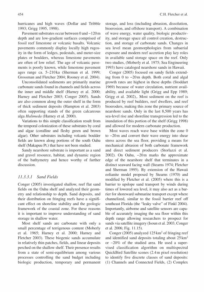
Most waves reach wave base within the zone 0 to −20 m and convert their wave energy into shear stress across the sea floor, providing a means for mechanical abrasion of both carbonate framework and direct sediment producers (Storlazzi et al. 2002). On Oahu , −20 m marks the approximate edge of the nearshore shelf that terminates in a distinct seaward facing wall (Stearns 1974; Fletcher and Sherman 1995). By extension of the Hawaii eolianite model proposed by Stearns (1970) and modified by Fletcher et al. (2005) where this is a barrier to upslope sand transport by winds during times of lowered sea level, it may also act as a bar-rier for shoreward submarine transport except where channelized, similar to the fossil barrier reef off southeast Florida (the “leaky valve” of Finkl 2004). Importantly, airborne and satellite sensors are capa-ble of accurately imaging the sea floor within this depth range allowing researchers to prospect for sands via satellite imagery (Isoun et al. 2003, Conger et al. 2006; Fig. 11.15).
Conger (2005) analyzed 125 km2 of fringing reef and identified sand deposits totaling about 25 km2 or ∼20% of the studied area. He used a super-vised classification algorithm on multispectral QuickBird Satellite scenes (2.4 m pixel resolution) to identify five discrete classes of sand deposits: (1) Channels and Connected Fields, (2) Complex
11. Geology of Hawaii Reefs 455
Fields and Very Large Depressions, (3) Large Depressions and Fields, (4) Linear Deposits, and (5) Small Depressions and Simple Fields. This yielded a total of 14,037 sand deposits of five con-nected pixels or larger. He split these five classes into three depth groups, providing insight into sand storage variability on the reef flat : (1) 0 to −10 m, (2) −10 to −20 m, and (3) deposits that straddle the −10 m contour. The −10 m contour approximates the boundary of two reef sub-environments: (1) shallow reef limited by wave-generated shear stress where bathymetry largely reflects antecedent karst morphology , and (2) deeper reef where wave forces are less significant and the bathymetry is more likely to reflect modern coral framework accretion related to reef growth.
Channels and Connected Fields account for the majority (64%) of all sand deposit surface area, and Complex Fields and Very Large Depressions account for 18%. Just over 72% of all sand deposit surface area straddles the −10 m contour line, and 24% is shallower than −10 m. Combined sands crossing or shallower than −10 m represent more than 96% of all sand deposit surface area. When deposit classes are distinguished by depth range, Channels and Connected Fields that straddle the −10 m contour account for 63%, Complex Fields and Very Large Depressions shallower than −10 m account for 10%, and Complex Fields and Very Large Depressions that cross the −10 m contour account for 7%. Together, these three subgroups total 80% of all surface area for sand deposits.
Fig. 11.15. Variable nature of sand fields (red) on the fringing reef at Kailua Bay. The 10 m contour is outlined in green
456 C.H. Fletcher et al.
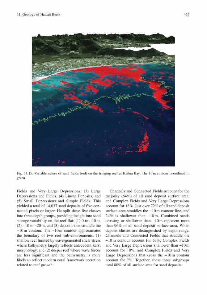
Conger (2005) summarized his findings in terms of the physical morphology of the Oahu shelf. He concludes that the first order control in sand storage is general shape of the reef (Fig. 11.16): wide reef vs. deep reef. Wide and shallow back
reefs with well-defined reef crests have more surface area covered by sand, while deeper fring-ing reefs and barrier reef fronts have less per-cent coverage. The second order control on sand fields is the energy environment on similar reef
Fig. 11.16. Sand fields (in black) on the Oahu shelf shallower than −20 m (Conger 2005)
11. Geology of Hawaii Reefs 457
geomorphologies. Sand storage is highest in the general reef morphology Conger calls “low-energy wide reef” located on the south shore of Oahu. His reef types “medium-energy wide,” “seasonal high-energy deep,” “medium-energy deep reef,” and “high-energy deep reef” have decreasing sand storage respectively. Hence, shallow, low energy shelf environments promote sand storage.
11.3.3.2 Sediment Production
Harney and Fletcher (2003) quantify a shelf sediment budget at Kailua Bay, Oahu . Although Kailua Bay has a well-developed modern coral community compared to the majority of the Oahu shelf, aspects of the sedimentology provide insight to island-wide patterns. Reefal sediments are pri-marily composed of carbonate skeletal fragments (> 90%) derived from two sources: (1) biological and mechanical erosion of the coral–algal reef framework and (2) direct sedimentation upon the death of organisms such as Halimeda, articulated coralline algae , molluscs , and benthic foraminif-era . Harney et al. (2000) report that shelf sands in Kailua range in age from modern to 4.5 ka, averag-ing ca. 1.5 ka, and that sand age varies with prox-imity to source, size fraction, and composition.
Harney and Fletcher (2003) estimate total annual calcareous sediment production over the 12 km2 reef system between 0 and −20 m water depth is 4,048 (±635) m3/year. Of this, bioerosion of coral and coralline algae species annually releases approximately 1,911 (± 436) m3/year of uncon-solidated sediment, and mechanical erosion (coral breakage) releases another 315 m3/year. Direct production of sediment by Halimeda, branching coralline algae, molluscs , and benthic foraminifera contribute a combined 1,822 (± 200) m3/year. Total production of sediment in Kailua Bay corresponds to an average rate of 0.53 (± 0.19) kg m−2/year. Of this, erosion of coralgal framework is responsible for approximately 0.33 (± 0.13) kg m−2/year and direct sediment production for 0.20 (± 0.06) kg m−2/year.
Sediment composition reflects the relative impor-tance of calcareous sediment producers (Harney et al. 2000). Most beach and submarine sediment assemblages are dominated by coralline algae (e.g., Porolithon , up to 50%) and Halimeda (up to 32%). Coral is generally a minor constituent (1–24%),
as are molluscs (6–21%), benthic foraminifera (1–10%), and echinoderms (<5%).
11.4 Lithostratigraphy of Reefs
In the presence of suitable environmental condi-tions including sufficient sunlight and nutrients, low hydrodynamic energy, water quality , and tem-perature, low latitude shelves accrete reefal lime-stones under high sea levels on amenable substrate (Purdy 1974; Stoddart 1969, Scholle et al. 1983).
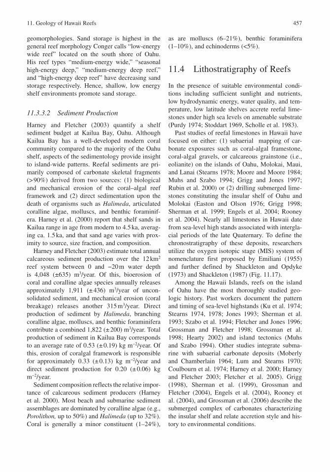
Past studies of reefal limestones in Hawaii have focused on either: (1) subaerial mapping of car-bonate exposures such as coral-algal framestone , coral-algal gravels, or calcareous grainstone (i.e., eolianite ) on the islands of Oahu , Molokai , Maui, and Lanai (Stearns 1978; Moore and Moore 1984; Muhs and Szabo 1994; Grigg and Jones 1997; Rubin et al. 2000) or (2) drilling submerged lime-stones constituting the insular shelf of Oahu and Molokai (Easton and Olson 1976; Grigg 1998; Sherman et al. 1999; Engels et al. 2004; Rooney et al. 2004). Nearly all limestones in Hawaii date from sea-level high stands associated with intergla-cial periods of the late Quaternary . To define the chronostratigraphy of these deposits, researchers utilize the oxygen isotopic stage (MIS ) system of nomenclature first proposed by Emiliani (1955) and further defined by Shackleton and Opdyke (1973) and Shackleton (1987) (Fig. 11.17).
Among the Hawaii Islands, reefs on the island of Oahu have the most thoroughly studied geo-logic history. Past workers document the pattern and timing of sea-level highstands (Ku et al. 1974; Stearns 1974, 1978; Jones 1993; Sherman et al. 1993; Szabo et al. 1994; Fletcher and Jones 1996; Grossman and Fletcher 1998; Grossman et al. 1998; Hearty 2002) and island tectonics (Muhs and Szabo 1994). Other studies integrate subma-rine with subaerial carbonate deposits (Moberly and Chamberlain 1964; Lum and Stearns 1970; Coulbourn et al. 1974; Harney et al. 2000; Harney and Fletcher 2003; Fletcher et al. 2005). Grigg (1998), Sherman et al. (1999), Grossman and Fletcher (2004), Engels et al. (2004), Rooney et al. (2004), and Grossman et al. (2006) describe the submerged complex of carbonates characterizing the insular shelf and relate accretion style and his-tory to environmental conditions.
458 C.H. Fletcher et al.
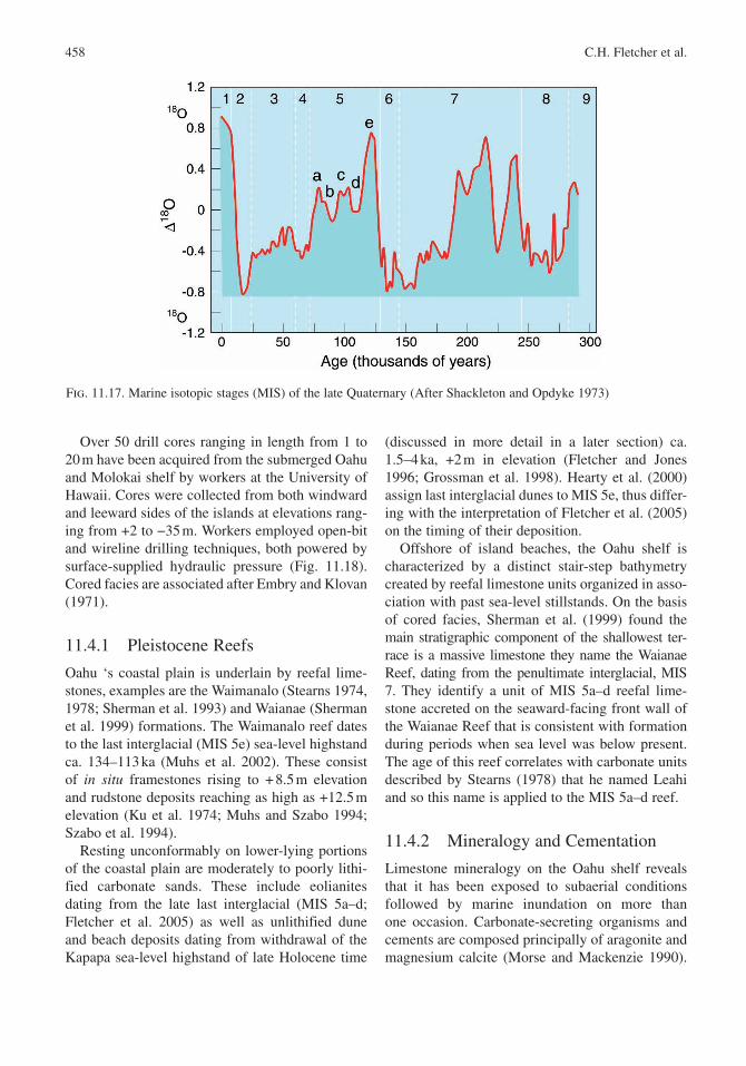
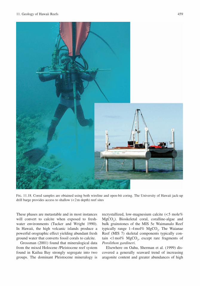
Over 50 drill cores ranging in length from 1 to 20 m have been acquired from the submerged Oahu and Molokai shelf by workers at the University of Hawaii. Cores were collected from both windward and leeward sides of the islands at elevations rang-ing from +2 to −35 m. Workers employed open-bit and wireline drilling techniques, both powered by surface-supplied hydraulic pressure (Fig. 11.18). Cored facies are associated after Embry and Klovan (1971).
11.4.1 Pleistocene Reefs
Oahu ‘s coastal plain is underlain by reefal lime-stones, examples are the Waimanalo (Stearns 1974, 1978; Sherman et al. 1993) and Waianae (Sherman et al. 1999) formations. The Waimanalo reef dates to the last interglacial (MIS 5e) sea-level highstand ca. 134–113 ka (Muhs et al. 2002). These consist of in situ framestones rising to + 8.5 m elevation and rudstone deposits reaching as high as +12.5 m elevation (Ku et al. 1974; Muhs and Szabo 1994; Szabo et al. 1994).
Resting unconformably on lower-lying portions of the coastal plain are moderately to poorly lithi-fied carbonate sands. These include eolianites dating from the late last interglacial (MIS 5a–d; Fletcher et al. 2005) as well as unlithified dune and beach deposits dating from withdrawal of the Kapapa sea-level highstand of late Holocene time
(discussed in more detail in a later section) ca. 1.5–4 ka, +2 m in elevation (Fletcher and Jones 1996; Grossman et al. 1998). Hearty et al. (2000) assign last interglacial dunes to MIS 5e, thus differ-ing with the interpretation of Fletcher et al. (2005) on the timing of their deposition .
Offshore of island beaches, the Oahu shelf is characterized by a distinct stair-step bathymetry created by reefal limestone units organized in asso-ciation with past sea-level stillstands. On the basis of cored facies , Sherman et al. (1999) found the main stratigraphic component of the shallowest ter-race is a massive limestone they name the Waianae Reef , dating from the penultimate interglacial , MIS 7. They identify a unit of MIS 5a–d reefal lime-stone accreted on the seaward-facing front wall of the Waianae Reef that is consistent with formation during periods when sea level was below present. The age of this reef correlates with carbonate units described by Stearns (1978) that he named Leahi and so this name is applied to the MIS 5a–d reef.
11.4.2 Mineralogy and Cementation
Limestone mineralogy on the Oahu shelf reveals that it has been exposed to subaerial conditions followed by marine inundation on more than one occasion. Carbonate-secreting organisms and cements are composed principally of aragonite and magnesium calcite (Morse and Mackenzie 1990).
Fig. 11.17. Marine isotopic stages (MIS ) of the late Quaternary (After Shackleton and Opdyke 1973)
11. Geology of Hawaii Reefs 459
These phases are metastable and in most instances will convert to calcite when exposed to fresh-water environments (Tucker and Wright 1990). In Hawaii, the high volcanic islands produce a powerful orographic effect yielding abundant fresh ground water that converts fossil corals to calcite.
Grossman (2001) found that mineralogical data from the mixed Holocene /Pleistocene reef system found in Kailua Bay strongly segregate into two groups. The dominant Pleistocene mineralogy is
recrystallized, low-magnesium calcite (< 5 mole% MgCO3). Bioskeletal coral, coralline-algae and bulk grainstones of the MIS 5e Waimanalo Reef typically range 1–4 mol% MgCO3. The Waianae Reef (MIS 7) skeletal components typically con-tain <1 mol% MgCO3, except rare fragments of Porolithon gardineri.
Elsewhere on Oahu , Sherman et al. (1999) dis-covered a generally seaward trend of increasing aragonite content and greater abundances of high
Fig. 11.18. Cored samples are obtained using both wireline and open-bit coring. The University of Hawaii jack-up drill barge provides access to shallow (< 2 m depth) reef sites
460 C.H. Fletcher et al.
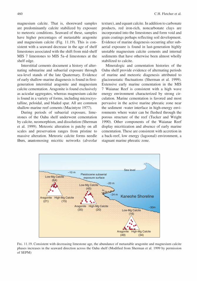
magnesium calcite. That is, shoreward samples are predominantly calcite stabilized by exposure to meteoric conditions. Seaward of these, samples have higher percentages of metastable aragonite and magnesium calcite (Fig. 11.19). This is con-sistent with a seaward decrease in the age of shelf limestones associated with the shift from mid-shelf MIS 7 limestones to MIS 5a–d limestones at the shelf edge.
Interstitial cements document a history of alter-nating submarine and subaerial exposure through sea-level stands of the late Quaternary . Evidence of early shallow-marine diagenesis is found in first-generation interstitial aragonite and magnesium calcite cementation. Aragonite is found exclusively as acicular aggregates, whereas magnesium calcite is found in a variety of forms, including microcrys-talline, peloidal, and bladed spar. All are common shallow-marine reef cements (Macintyre 1977).
During periods of subaerial exposure, lime-stones of the Oahu shelf underwent cementation by calcite, neomorphism, and dissolution (Sherman et al. 1999). Meteoric alteration is patchy on all scales and preservation ranges from pristine to massive alteration. Meteoric calcite forms needle fibers, anastomosing micritic networks (alveolar
texture), and equant calcite. In addition to carbonate products, red iron-rich, noncarbonate clays are incorporated into the limestones and form void and grain coatings perhaps reflecting soil development. Evidence of marine diagenesis occurring after sub-aerial exposure is found in last-generation highly unstable magnesium calcite cements and internal sediments that have otherwise been almost wholly stabilized to calcite.
Mineralogic and cementation histories of the Oahu shelf provide evidence of alternating periods of marine and meteoric diagenesis attributed to glacioeustatic fluctuations (Sherman et al. 1999). Extensive early marine cementation in the MIS 7 Waianae Reef is consistent with a high wave energy environment characterized by strong cir-culation. Marine cementation is favored and most pervasive in the active marine phreatic zone near the sediment -water interface in high-energy envi-ronments where water can be flushed through the porous structure of the reef (Tucker and Wright 1990). Other components of the Waianae Reef display micritization and absence of early marine cementation. These are consistent with accretion in a back-reef, low energy (lagoonal) environment, a stagnant marine phreatic zone.
−10 mPleistocene subaerial
exposure surface
−20 m
Kaneohe Shoreline −24 m
−30m
Sea level
Low-Mg Calcite(64)
Aragonite(21)
High-Mg Calcite(15)
Low-Mg Calcite(45)
Aragonite(35)
High-Mg Calcite(20) Low-Mg Calcite
(16)
Aragonite(49)
High-Mg Calcite(34)
Fig. 11.19. Consistent with decreasing limestone age, the abundance of metastable aragonite and magnesium calcite phases increases in the seaward direction across the Oahu shelf (Modified from Sherman et al. 1999 by permission of SEPM)
11. Geology of Hawaii Reefs 461
Notably, the diagenetic record in Waianae limestones appears to reflect local meteorological conditions. The Oahu shelf was subaerially exposed during sea-level lowerings of MIS 6 and again following MIS 5a. However, there is no direct evidence of meteoric vadose zone alteration of western Oahu shelf limestones. Sherman et al. (1999) speculate that this was probably a result of the rain shadow effect that impacts the leeward side of Oahu where many of their deeper cores were obtained. This effect would be magnified during low sea-level conditions related to increased rain shadowing (aridity) in that region. However, in windward Kailua Bay, Grossman (2001) records a distinct pattern of lowered magnesium content in older (Waianae Reef – MIS 7) samples reflect-ing the influence of MIS 6 exposure in a wetter environment where orographic rainfall would be enhanced by sea-level lowering.
Post-meteoric marine cementation is extensive in Waianae Reef samples that experienced stagnant marine phreatic zone conditions (lagoonal deposi-tion ) during their early accretion. During periods of subaerial emergence (during glacioeustatic low-stands) these limestones were stabilized and lithified to calcite in a meteoric environment and underwent partial solution and creation of vug and channel porosity. When subsequently drowned again (during glacioeustatic highstands) the stabilized, lithified substrate characterized by conduit or channel-type porosity, hosted high marine flow rates induced by channelized seawater. This resulted in precipitation of thick isopachous rims of bladed magnesium cal-cite spar lining the walls of large voids.
The general trend of decreasing mineralogic stabilization progressing seaward across the terrace is consistent with Th-U ages of fossil corals from these deposits, i.e., less mineralogic stabilization in the younger limestones. The age of carbonate systems is discussed in the next section.
11.4.3 Age of Carbonate Systems
Th-U and radiocarbon ages of carbonate systems document their age and history on both the coastal plain and shallow shelf. Fossil corals fall into four age groupings. (1) Where the shelf is a fossil limestone surface in the absence of modern coral growth (“pavement facies ” of Grossman et al. 2006), samples from the outer edge of the shelf
range 82.8–110.1 ka (MIS 5a–d); (2) those from the middle and inner portion of the shelf range 206.4–247.2 ka (MIS 7). A third group (3), found composing most rocky limestone coasts (and the offshore islet of Popoia in Kailua Bay), document last interglacial MIS 5e ages when sea level was above present. The fourth group (4), Holocene in age, is found on the middle to outer shelf (occa-sionally accompanied by modern coral growth), and on some very shallow fringing reefs of Oahu and Molokai (Rooney et al. 2004). These typically document early to middle Holocene ages (MIS 1) where exposed to north swell and middle to late Holocene ages in protected settings and where exposed to south swell (Grossman et al. 2006). Calibrated radiocarbon ages of in situ Holocene framework corals range modern to >7 ka. This range is confirmed by two Th-U ages ca. 5.3–7.8 ka (Grossman and Fletcher 2004).
Age-corrected 234U/238U in coral should compare to modern seawater if the coral has remained chem-ically pristine since fossilization and if 234U/238U in seawater has remained constant through the Quaternary . δ234U in modern corals and δ234Ui in Holocene corals are typically indistinguishable from modern seawater (Chen et al. 1986; Edwards et al. 1986; Rubin et al. 2000). Further, various workers have suggested that 234U/238U in seawater has been essentially constant over the past 250 ka (Henderson et al. 1993). Elevated δ234Ui observed in some older corals likely indicates open-system behavior (Bard et al. 1996a, b; Sherman et al. 1999; Gallup et al. 1994; Hamelin et al. 1991), although some have suggested that 234U/238U in seawater may have differed in the past (Hamelin et al. 1991). Most workers apply a “working definition” of 230Th-234U-238U age quality based on δ 234Ui rela-tive to modern: 145–153‰ is considered “highly reliable”, 139–159‰ or 165‰ is “moderately reli-able”, and δ234Ui >165‰ is “less reliable” (Bard et al. 1996a; Szabo et al. 1994; Stirling et al. 1998). These ranges are somewhat arbitrary because “acceptable” δ234Ui varies with how and when open-system behavior occurred and the absolute age of the sample, and because not all open-system events that modify δ234Ui also affect sample age (Chen et al. 1991; Hamelin et al. 1991).
Sherman et al. (1999) document the age- corrected 234U/238U values of their dated coral samples. Older corals from the Oahu shelf have δ234Ui that range
462 C.H. Fletcher et al.
from 149‰ to 254‰ indicating diagenetic altera-tion in some samples and probable age biasing. Sample MAI5–1S1 (234U/238U = 149.0 (±1.0) ‰; Sherman et al. 1999) provides the most reliable age for the Waianae Reef , 223.3 (±1.5) ka. With the exception of two samples, the younger corals collected at the seaward margin of the shelf have δ 234Ui values that cluster within the range 149 (±10) ‰ and thus provide reliable ages (ca. 82–110 ka).
Fletcher et al. (2005) interpret amino acid racemisation data from both Molokai and Oahu coastal plain deposits and correlate calcarenite formation to late MIS 5. The current mean annual temperature in Hawaii is about 25°C hence diage-netic temperatures are likely to have been relatively stable over the late Quaternary . A geochronological framework for assessing AAR data is provided by independently dated Periglypta reticulata (mol-lusc) remains from Barbers Point and Kapapa Island, Oahu (Sherman et al. 1993; Grossman and Fletcher 1998). Also available are two submerged coral samples from Oahu independently dated by the TIMS U-series method, and an electron spin resonance (ESR) age of 562 (±96) ka on Middle Pleistocene coral from Barbers Point (Sherman et al. 1993).
The low extent of racemisation in P. reticulata samples from Kapapa Island is consistent with their middle Holocene age determined by radiocarbon (Fletcher and Jones 1996; Grossman and Fletcher 1998), and by analogy with extensive comparisons of Holocene AAR and radiocarbon ages (Murray-Wallace 1993, 1995). In contrast, a significantly higher extent of racemisation is evident for P. reticulata from a last interglacial coral rudstone unit at Barbers Point (Unit III of Sherman et al. 1993). These correlate well with last interglacial molluscs in Australia that have equivalent current mean annual temperatures (Murray-Wallace 1995).
11.4.4 Lithofacies
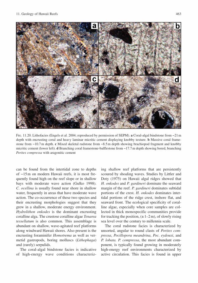
Skeletal components of cored limestones on the Oahu shelf (Fig. 11.20) are typical of reefal environments and include coralline algae , coral, molluscs , echinoderms , and benthic foraminifers. Terrigenous input is limited to rare volcanic clasts, grain and void coatings of iron-rich clay.
In past work on the Oahu shelf (Sherman et al. 1999), Hawaii reefal limestones were classified
into biolithofacies on the basis of their dominant skeletal component and fabric. Two facies were described: (1) massive coral, and (2) branch-ing coral. Each facies included both an autoch-thonous (in situ) and allochthonous component. The massive coral facies incorporated coarse skel-etal grainstones and rudstones , as well as encrust-ing bindstones predominately of crustose coralline algae . The dominance of massive corals (i.e., Porites lobata) and encrusting algae indicates a shallow marine high-energy environment of depo-sition . The branching coral facies included delicate branching corals (i.e., Pocillopora damicornis), coralline algae, and other biota set in a lime-mud matrix forming in situ bafflestones, floatstones, or wackestones. The presence of delicate branching corals and lime-mud matrix indicate a low energy environment of deposition such as a lagoonal or embayed setting, or the inner parts of large reef flats away from breaking waves.
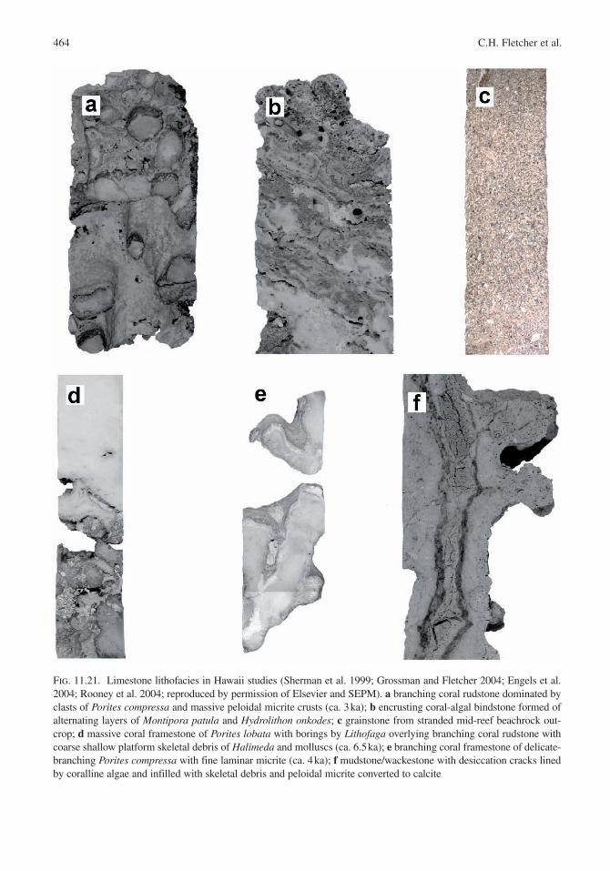
Grossman and Fletcher (2004) adopted a clas-sification with five facies (Fig. 11.21) encountered in their work in Kailua Bay. In order of decreasing depositional energy, these are: (1) encrusting coral-algal bindstone facies, (2) coral rudstone facies, (3) grainstone facies, (4) massive coral framestone facies, and (5) branching coral framestone facies. Engels et al. (2004), working on the nearby island of Molokai with cores from the south shore fring-ing reef, encountered the same bindstone, rudstone, massive framestone, and branching framestone facies described by Grossman and Fletcher (2004). However, they failed to find a grainstone facies, and they describe an “unconsolidated floatstone” facies in their work.
Because the distribution of many coral and coral-line algae species is governed by temperature, light levels, nutrient levels, and wave energy , facies can serve as paleoecologic indicators of the Quaternary (Adey 1986; Cabioch et al. 1999).
As described by Grossman and Fletcher (2004), the encrusting coral-algal bindstone facies consists of in situ encrusting forms of coral and coralline algae with occasional grainstones, rudstones and algal rhodoliths. Typical corals include Montipora patula, Cyphastrea ocellina, P. lobata, and M. capitata. These are found either as in situ bindstones with a semifriable coarse grainstone to rudstone matrix, or as unconsolidated subrounded to angular, oblate to bladed, pebble-size clasts. Although M. patula
11. Geology of Hawaii Reefs 463
can be found from the intertidal zone to depths of −15 m on modern Hawaii reefs, it is most fre-quently found high on the reef slope or in shallow bays with moderate wave action (Gulko 1998). C. ocellina is usually found near shore in shallow water, frequently in areas that have moderate wave action. The co-occurrence of these two species and their encrusting morphologies suggest that they grew in a shallow, moderate energy environment. Hydrolithon onkodes is the dominant encrusting coralline alga. The crustose coralline algae Tenarea tessellatum is also common. This assemblage is abundant on shallow, wave-agitated reef platforms along windward Hawaii shores. Also present is the encrusting foraminifer Homotrema as well as ver-metid gastropods, boring molluscs (Lithophaga) and (rarely) serpulids.
The coral-algal bindstone facies is indicative of high-energy wave conditions characteriz-
ing shallow reef platforms that are persistently scoured by shoaling waves. Studies by Littler and Doty (1975) on Hawaii algal ridges showed that H. onkodes and P. gardineri dominate the seaward margin of the reef. P. gardineri dominates subtidal portions of the crest. H. onkodes dominates inter-tidal portions of the ridge crest, inshore flat, and seaward front. The ecological specificity of coral-line algae , especially when core samples are col-lected in thick monospecific communities provide for tracking the position, (± 1–2 m), of slowly rising sea level over the century to millennia scale.
The coral rudstone facies is characterized by unsorted, angular to round clasts of Porites com-pressa, Pocillopora meandrina, Poc. eydouxi, and P. lobata. P. compressa, the most abundant com-ponent, is typically found growing in moderately high-energy reef environments characterized by active circulation. This facies is found in upper
Fig. 11.20. Lithofacies (Engels et al. 2004; reproduced by permission of SEPM). a Coral-algal bindstone from −21 m depth with encrusting coral and heavy laminar micritic cement displaying knobby texture. b Massive coral frame-stone from −10.7 m depth. c Mixed skeletal rudstone from −8.5 m depth showing brachiopod fragment and knobby micritic cement (lower left). d Branching coral framestone-bafflestone from −17.7 m depth showing bored, branching Porites compressa with aragonitic cement
464 C.H. Fletcher et al.
Fig. 11.21. Limestone lithofacies in Hawaii studies (Sherman et al. 1999; Grossman and Fletcher 2004; Engels et al. 2004; Rooney et al. 2004; reproduced by permission of Elsevier and SEPM). a branching coral rudstone dominated by clasts of Porites compressa and massive peloidal micrite crusts (ca. 3 ka); b encrusting coral-algal bindstone formed of alternating layers of Montipora patula and Hydrolithon onkodes; c grainstone from stranded mid-reef beachrock out-crop; d massive coral framestone of Porites lobata with borings by Lithofaga overlying branching coral rudstone with coarse shallow platform skeletal debris of Halimeda and molluscs (ca. 6.5 ka); e branching coral framestone of delicate-branching Porites compressa with fine laminar micrite (ca. 4 ka); f mudstone/wackestone with desiccation cracks lined by coralline algae and infilled with skeletal debris and peloidal micrite converted to calcite
11. Geology of Hawaii Reefs 465
sections of a central reef platform. Thin crusts of H. onkodes frequently envelope single and multiple coral clasts indicating encrustation preceded final deposition . Additional skeletal components include fragments of Halimeda, molluscs , branching coral-line algae , echinoderma and foraminifera . Cored samples display burrows, borings and secondary encrustation by foraminifera and bryozoans. The rudstone facies represents a high-energy deposi-tional environment generally consisting of coral fragments originally derived from protected (deeper fore reef ) settings.
Relatively rare, grainstone facies is composed of medium to coarse, rounded skeletal fragments of coralline algae , coral and molluscs . This facies is formed by cementation of former moderate to high-energy beach ridges stranded by shoreline retreat in reef flat settings. Halimeda grains are present and typically fine to medium size. Isopachous magne-sium calcite rim cements coat grains and partially fill interstitial void space.
Typical of the massive coral framestone facies , P. lobata is the most common and widespread of Hawaii corals and can occur anywhere from the intertidal zone to depths of −40 m. However, P. lobata is most common high on wave-exposed reef slopes just below highest wave action between depths of −3 to −15 m (Maragos 1977; Gulko 1998). Grigg (1998) showed where exposed to high wave energy P. lobata is the dominant reef builder. Crustose coralline algae (H. onkodes) are important members of the massive-coral facies. It occurs as sheet-like encrustations on the upper surfaces of corals, lining voids in coral framework , over previously lithified rudstone, and coating coral clasts in rudstones . The dominance of massive-corals along with encrusting algae indicates a shallow, high-energy environment of deposition (Tucker and Wright 1990; James and Bourque 1992). The combination of a grainstone and rudstone matrix with in situ framework is also common in high-energy, shallow water settings. This distribution is consistent with the expected zonation of lithofacies in a marginal reef complex, where rudstones and framestones are most common in reef flat , reef crest , and reef front environments (James and Bourque 1992).
The branching coral framestone facies is composed of delicate, in situ branching corals (Poc. damicornis and P. compressa), coralline algae , and associated biota set in a lime-mud matrix forming
in situ bafflestones, floatstones, or wackestones. In Hawaii, Pocillopora damicornis is usually found in protected bays or upon the inner parts of large reef flats away from breaking waves (Maragos 1977). Likewise P. compressa, the most competitively superior coral species in low wave energy environ-ments, is often found on the fore reef where it can monopolize substrate until disturbance intervenes. The presence of Poc. damicornis and dominance of a lime-mud matrix indicate a low-energy environ-ment of deposition typically along inner parts of a reef flat landward of the massive-coral facies. In the case of P. compressa, the assemblage may indicate reef flat or fore reef settings near or below wave base.
Mudstone/wackestone units are relatively rare in Hawaii fringing reefs . They are characterized by infilled cavities with a fine, white semifriable powder or as a brown, clotted, indurated lime mud. This lithology is restricted to the lower sections of shallow core sites on the fringing reef flat but has also been found in at least one deeper core site reoccurring throughout the sequence.
11.4.5 Assembly of the Oahu Shelf
A complex history of reef, dune , and coastal plain accretion during the late Quaternary has produced a mosaic of stratigraphic components comprising the shallow coastal plain and shelf of Oahu (Fig. 11.22).
11.4.5.1 MIS 7 – Waianae Reef
The earliest reef accretion on the Oahu shelf for which there is widespread evidence dates to middle MIS 7 (Fig. 11.23a). The duration of MIS 7 is 182–242 ka (Bassinot et al. 1994). Four well-preserved coral samples from both windward and leeward sides of Oahu provide absolute 230Th-234U-238U ages dating 206–247 ka within acceptable limits of δ234Ui (δ
234Ui < 165‰).On leeward Oahu , cored facies reveal MIS 7 fos-
sil reef crest communities of in situ stout branching and massive P. lobata comprising the reef frame-work . Windward Oahu cores of the Waianae Reef display a high-energy community of encrusting crustose algae (e.g., Hydrolithon onkodes) charac-teristic of shallow subtidal to intertidal algal ridges at the seaward margin of fringing reefs throughout the central and eastern Pacific. Post-glacial flooding by Holocene sea level is responsible for Holocene
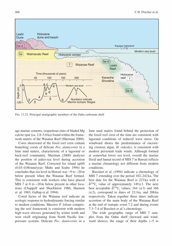
466 C.H. Fletcher et al.
age marine cements, isopachous rims of bladed Mg calcite spar (ca. 2.8–5.6 ka) found within the frame-work matrix of the Waianae Reef (Sherman 2000).
Cores shoreward of the fossil reef crest contain branching corals of delicate Poc. damicornis in a lime mud matrix, characteristic of a lagoonal or back-reef community. Sherman (2000) analyzes the position of paleo-sea level during accretion of the Waianae Reef . Corrected for island uplift (0.03–0.06 mm/year; Muhs and Szabo 1994) he concludes that sea level in Hawaii was −9 to −20 m below present when the Waianae Reef formed. This is consistent with workers who have placed MIS 7 at 0 to −20 m below present in other loca-tions (Chappell and Shackleton 1986; Harmon et al. 1983; Gallup et al. 1994).
Cored facies of the Waianae reef indicate an ecologic response to hydrodynamic forcing similar to modern conditions. Massive P. lobata compris-ing the reef framework is consistent with modern high wave stresses generated by winter north and west swell originating from North Pacific low-pressure systems. Delicate Poc. damicornis in a
lime mud matrix found behind the protection of the fossil reef crest of the time are consistent with lagoonal conditions of reduced wave stress. On windward shores the predominance of encrust-ing crustose algae, H. onkodes, is consistent with modern persistent trade winds. Although formed at somewhat lower sea level, overall the marine floral and faunal record of MIS 7 in Hawaii reflects a marine climatology not different from modern conditions.
Bassinot et al. (1994) indicate a chronology of MIS 7 extending over the period 182–242 ka. The best date for the Waianae Reef is 223 ka with a δ234Ui value of approximately 149 ± 3. The next best acceptable δ234Ui values, 164 (± 3) and 166 (± 2), correspond to dates of 211 ka, and 206 ka respectively. Taken together these dates indicate accretion of the main body of the Waianae Reef at the end of isotopic event 7.2 and during events 7.3–7.4 of Bassinot et al.’s chronology.
The wide geographic range of MIS 7 sam-ples from the Oahu shelf (leeward and wind-ward shores), the range of their depths (−5 to
Kapapa highstand(+ 2 m)
Modern sea level
LeahiReef
Holocenereef
Waianae Reef
Waimanalo Reef
LeahiDune
Holocenedune and beach
5a-d
5a-d
5a-d
5e
7
1
Holocene veneer
KaneoheShoreline
0
−120
10050 200150
Dep
th (m
)
Time (thousands of years)
Numbers indicateMarine Isotopic Stages
1
23
465
a
b
c
d 7
e Modern sea level
Fig. 11.22. Principal stratigraphic members of the Oahu carbonate shelf
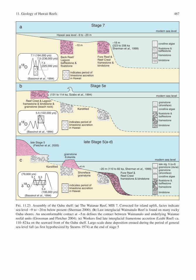
11. Geology of Hawaii Reefs 467
modern sea level
Stage 7
Fore Reef & Reef Crestframestone &bindstone
Back Reef/ Lagoonbafflestone &floatstone
a
–10 m–18 m(223 to 206 kaSherman et al., 1999)
δ18O
7.1 (194,000 yrs)7.5 (236,000 yrs)
7.4(225,000 yrs)
(Bassinot et al., 1994)
coralline algae
floatstone &bafflestone
framestone
bindstone
indicates period oflimestone accretionin Hawaii
Hawaii sea level –9 to –20 m
modern sea level
Stage 5e
Reef Crest & Lagoonframestone & bindstone &grainstone (beach rock)
Karstified
b
(131 to 114 ka, Szabo et al., 1994)
δ18O
5.5 (122,000 yrs)
(Bassinot et al., 1994)
grainstone(shoreface)
coralline algae
floatstone &bafflestone
framestone
bindstoneindicates period oflimestone accretionin Hawaii
–20 m (110 to 82 ka, Sherman et al., 1999)
modern sea level
late Stage 5(a-d)
Karstified
Shorefacegrainstone
Fore Reef & Reef Crestframestone & bindstone
grainstoneEolianite
c
late Stage 5 (Fletcher et al., 2005)
–4 m
δ18O
5.4(106,000 yrs)
(79,000 yrs)5.1
(Bassinot et al., 1994)
5.3
late stg. 5 (a-d)grainstone (dune)grainstone (shoreface)coralline algae
floatstone &bafflestoneframestone
bindstone
indicates period oflimestone accretionin Hawaii
Fig. 11.23. Assembly of the Oahu shelf: (a) The Waianae Reef , MIS 7. Corrected for island uplift , facies indicate sea-level −9 to −20 m below present (Sherman 2000). (b) Last interglacial Waimanalo Reef is found on many rocky Oahu shores. An unconformable contact at −5 m defines the contact between Waimanalo and underlying Waianae reefal units (Grossman and Fletcher 2004). (c) Workers find late interglacial framestone accretion (Leahi Reef) ca. 110–82 ka on the seaward front of the Oahu shelf. Large-scale dune deposition ensued during the period of general sea-level fall (as first hypothesized by Stearns 1974) at the end of stage 5
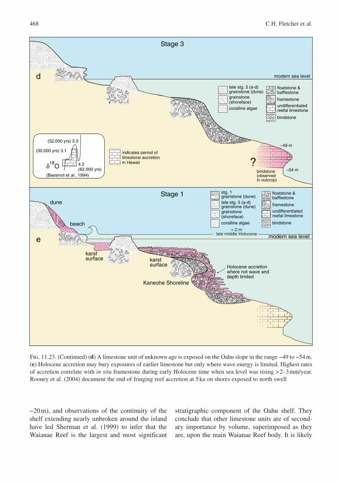
468 C.H. Fletcher et al.
−20 m), and observations of the continuity of the shelf extending nearly unbroken around the island have led Sherman et al. (1999) to infer that the Waianae Reef is the largest and most significant
stratigraphic component of the Oahu shelf. They conclude that other limestone units are of second-ary importance by volume, superimposed as they are, upon the main Waianae Reef body. It is likely
bindstone
–54 m
–49 m
modern sea level
Stage 3
bindstone(observed in outcrop)
d
?δ18O 4.2
(62,000 yrs)
(52,000 yrs) 3.3
(Bassinot et al., 1994)
(30,000 yrs) 3.1
late stg. 5 (a-d)grainstone (dune)grainstone (shoreface)coralline algae
floatstone &bafflestone
framestone
undifferentiatedreefal limestone
indicates period oflimestone accretionin Hawaii
+ 2 mlate middle Holocene
Stage 1
Holocene accretion where not wave anddepth limited
karstsurface
karstsurface
dune
beach
e modern sea level
bindstone
late stg. 5 (a-d)grainstone (dune)grainstone (shoreface)coralline algae
floatstone &bafflestone
framestone
undifferentiatedreefal limestone
stg. 1 grainstone (dune)
Kaneohe Shoreline
Fig. 11.23. (Continued) (d) A limestone unit of unknown age is exposed on the Oahu slope in the range −49 to −54 m. (e) Holocene accretion may bury exposures of earlier limestone but only where wave energy is limited. Highest rates of accretion correlate with in situ framestone during early Holocene time when sea level was rising > 2–3 mm/year. Rooney et al. (2004) document the end of fringing reef accretion at 5 ka on shores exposed to north swell
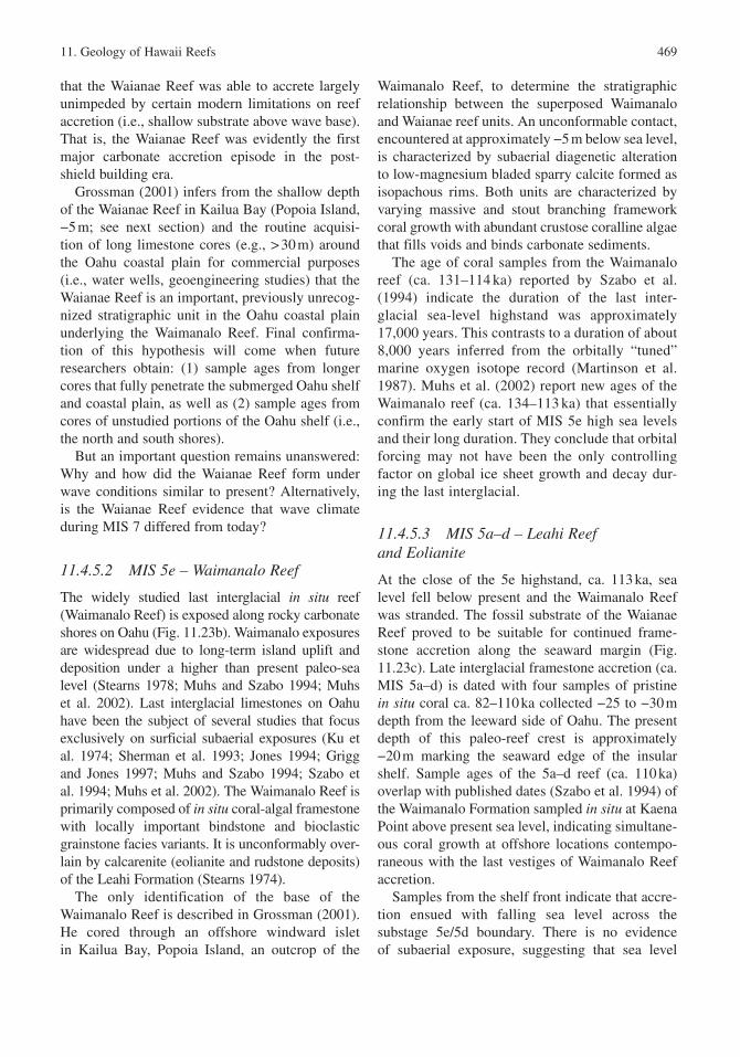
11. Geology of Hawaii Reefs 469
that the Waianae Reef was able to accrete largely unimpeded by certain modern limitations on reef accretion (i.e., shallow substrate above wave base). That is, the Waianae Reef was evidently the first major carbonate accretion episode in the post-shield building era.
Grossman (2001) infers from the shallow depth of the Waianae Reef in Kailua Bay (Popoia Island, −5 m; see next section) and the routine acquisi-tion of long limestone cores (e.g., > 30 m) around the Oahu coastal plain for commercial purposes (i.e., water wells, geoengineering studies) that the Waianae Reef is an important, previously unrecog-nized stratigraphic unit in the Oahu coastal plain underlying the Waimanalo Reef . Final confirma-tion of this hypothesis will come when future researchers obtain: (1) sample ages from longer cores that fully penetrate the submerged Oahu shelf and coastal plain, as well as (2) sample ages from cores of unstudied portions of the Oahu shelf (i.e., the north and south shores).
But an important question remains unanswered: Why and how did the Waianae Reef form under wave conditions similar to present? Alternatively, is the Waianae Reef evidence that wave climate during MIS 7 differed from today?
11.4.5.2 MIS 5e – Waimanalo Reef
The widely studied last interglacial in situ reef (Waimanalo Reef ) is exposed along rocky carbonate shores on Oahu (Fig. 11.23b). Waimanalo exposures are widespread due to long-term island uplift and deposition under a higher than present paleo-sea level (Stearns 1978; Muhs and Szabo 1994; Muhs et al. 2002). Last interglacial limestones on Oahu have been the subject of several studies that focus exclusively on surficial subaerial exposures (Ku et al. 1974; Sherman et al. 1993; Jones 1994; Grigg and Jones 1997; Muhs and Szabo 1994; Szabo et al. 1994; Muhs et al. 2002). The Waimanalo Reef is primarily composed of in situ coral-algal framestone with locally important bindstone and bioclastic grainstone facies variants. It is unconformably over-lain by calcarenite (eolianite and rudstone deposits) of the Leahi Formation (Stearns 1974).
The only identification of the base of the Waimanalo Reef is described in Grossman (2001). He cored through an offshore windward islet in Kailua Bay, Popoia Island, an outcrop of the
Waimanalo Reef, to determine the stratigraphic relationship between the superposed Waimanalo and Waianae reef units. An unconformable contact, encountered at approximately −5 m below sea level, is characterized by subaerial diagenetic alteration to low-magnesium bladed sparry calcite formed as isopachous rims. Both units are characterized by varying massive and stout branching framework coral growth with abundant crustose coralline algae that fills voids and binds carbonate sediments.
The age of coral samples from the Waimanalo reef (ca. 131–114 ka) reported by Szabo et al. (1994) indicate the duration of the last inter-glacial sea-level highstand was approximately 17,000 years. This contrasts to a duration of about 8,000 years inferred from the orbitally “tuned” marine oxygen isotope record (Martinson et al. 1987). Muhs et al. (2002) report new ages of the Waimanalo reef (ca. 134–113 ka) that essentially confirm the early start of MIS 5e high sea levels and their long duration. They conclude that orbital forcing may not have been the only controlling factor on global ice sheet growth and decay dur-ing the last interglacial.
11.4.5.3 MIS 5a–d – Leahi Reef and Eolianite
At the close of the 5e highstand , ca. 113 ka, sea level fell below present and the Waimanalo Reef was stranded. The fossil substrate of the Waianae Reef proved to be suitable for continued frame-stone accretion along the seaward margin (Fig. 11.23c). Late interglacial framestone accretion (ca. MIS 5a–d) is dated with four samples of pristine in situ coral ca. 82–110 ka collected −25 to −30 m depth from the leeward side of Oahu . The present depth of this paleo-reef crest is approximately −20 m marking the seaward edge of the insular shelf. Sample ages of the 5a–d reef (ca. 110 ka) overlap with published dates (Szabo et al. 1994) of the Waimanalo Formation sampled in situ at Kaena Point above present sea level, indicating simultane-ous coral growth at offshore locations contempo-raneous with the last vestiges of Waimanalo Reef accretion.
Samples from the shelf front indicate that accre-tion ensued with falling sea level across the substage 5e/5d boundary. There is no evidence of subaerial exposure, suggesting that sea level
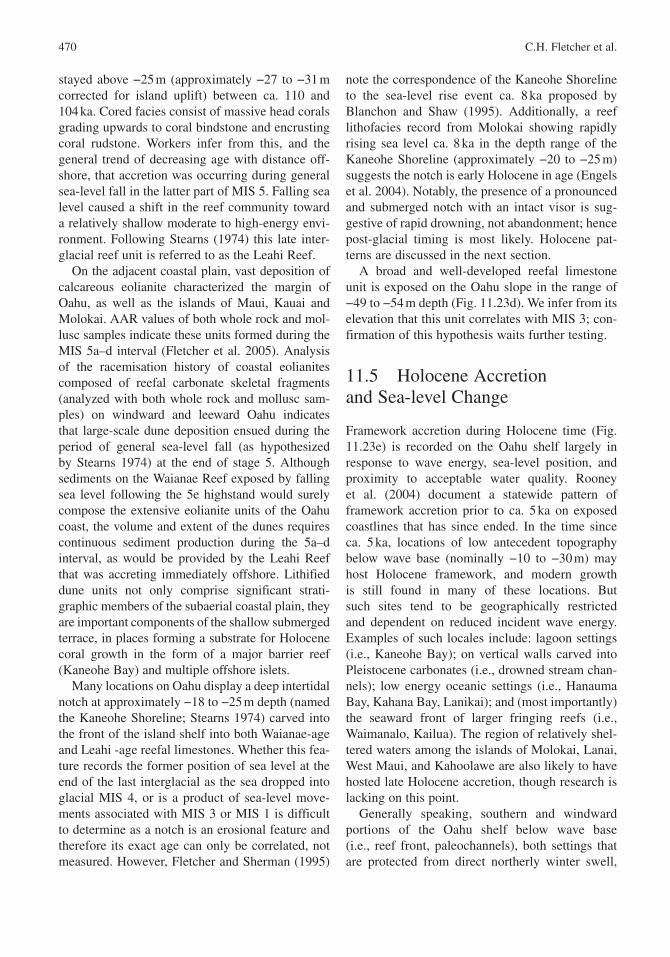
470 C.H. Fletcher et al.
stayed above −25 m (approximately −27 to −31 m corrected for island uplift ) between ca. 110 and 104 ka. Cored facies consist of massive head corals grading upwards to coral bindstone and encrusting coral rudstone. Workers infer from this, and the general trend of decreasing age with distance off-shore, that accretion was occurring during general sea-level fall in the latter part of MIS 5. Falling sea level caused a shift in the reef community toward a relatively shallow moderate to high-energy envi-ronment. Following Stearns (1974) this late inter-glacial reef unit is referred to as the Leahi Reef.
On the adjacent coastal plain, vast deposition of calcareous eolianite characterized the margin of Oahu , as well as the islands of Maui, Kauai and Molokai . AAR values of both whole rock and mol-lusc samples indicate these units formed during the MIS 5a–d interval (Fletcher et al. 2005). Analysis of the racemisation history of coastal eolianites composed of reefal carbonate skeletal fragments (analyzed with both whole rock and mollusc sam-ples) on windward and leeward Oahu indicates that large-scale dune deposition ensued during the period of general sea-level fall (as hypothesized by Stearns 1974) at the end of stage 5. Although sediments on the Waianae Reef exposed by falling sea level following the 5e highstand would surely compose the extensive eolianite units of the Oahu coast, the volume and extent of the dunes requires continuous sediment production during the 5a–d interval, as would be provided by the Leahi Reef that was accreting immediately offshore. Lithified dune units not only comprise significant strati-graphic members of the subaerial coastal plain, they are important components of the shallow submerged terrace, in places forming a substrate for Holocene coral growth in the form of a major barrier reef (Kaneohe Bay ) and multiple offshore islets.
Many locations on Oahu display a deep intertidal notch at approximately −18 to −25 m depth (named the Kaneohe Shoreline ; Stearns 1974) carved into the front of the island shelf into both Waianae-age and Leahi -age reefal limestones. Whether this fea-ture records the former position of sea level at the end of the last interglacial as the sea dropped into glacial MIS 4, or is a product of sea-level move-ments associated with MIS 3 or MIS 1 is difficult to determine as a notch is an erosional feature and therefore its exact age can only be correlated, not measured. However, Fletcher and Sherman (1995)
note the correspondence of the Kaneohe Shoreline to the sea-level rise event ca. 8 ka proposed by Blanchon and Shaw (1995). Additionally, a reef lithofacies record from Molokai showing rapidly rising sea level ca. 8 ka in the depth range of the Kaneohe Shoreline (approximately −20 to −25 m) suggests the notch is early Holocene in age (Engels et al. 2004). Notably, the presence of a pronounced and submerged notch with an intact visor is sug-gestive of rapid drowning , not abandonment; hence post-glacial timing is most likely. Holocene pat-terns are discussed in the next section.
A broad and well-developed reefal limestone unit is exposed on the Oahu slope in the range of −49 to −54 m depth (Fig. 11.23d). We infer from its elevation that this unit correlates with MIS 3; con-firmation of this hypothesis waits further testing.
11.5 Holocene Accretion and Sea-level Change
Framework accretion during Holocene time (Fig. 11.23e) is recorded on the Oahu shelf largely in response to wave energy , sea-level position, and proximity to acceptable water quality . Rooney et al. (2004) document a statewide pattern of framework accretion prior to ca. 5 ka on exposed coastlines that has since ended. In the time since ca. 5 ka, locations of low antecedent topography below wave base (nominally −10 to −30 m) may host Holocene framework, and modern growth is still found in many of these locations. But such sites tend to be geographically restricted and dependent on reduced incident wave energy. Examples of such locales include: lagoon settings (i.e., Kaneohe Bay ); on vertical walls carved into Pleistocene carbonates (i.e., drowned stream chan-nels); low energy oceanic settings (i.e., Hanauma Bay , Kahana Bay, Lanikai); and (most importantly) the seaward front of larger fringing reefs (i.e., Waimanalo, Kailua ). The region of relatively shel-tered waters among the islands of Molokai , Lanai , West Maui, and Kahoolawe are also likely to have hosted late Holocene accretion, though research is lacking on this point.
Generally speaking, southern and windward portions of the Oahu shelf below wave base (i.e., reef front, paleochannels), both settings that are protected from direct northerly winter swell ,
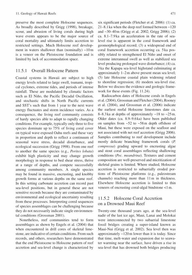
11. Geology of Hawaii Reefs 471
preserve the most complete Holocene sequences. As broadly described by Grigg (1998), breakage, scour, and abrasion of living corals during high wave events appears to be the major source of coral mortality and ultimately limits accretion to restricted settings. Much Holocene reef develop-ment in waters shallower than (nominally) −10 m is a veneer on the Pleistocene foundation and is limited by lack of accommodation space .
11.5.1 Overall Holocene Pattern
Coastal systems in Hawaii are subject to high energy levels related to large swell , tsunami , tropi-cal cyclones, extreme tides, and periods of intense rainfall. These are modulated by climatic factors such as El Niño, the Pacific Decadal Oscillation , and stochastic shifts in North Pacific currents and SST’s such that from 1 year to the next wave energy fluctuates and storm incidence varies. As a consequence, the living reef community consists of hardy species able to adapt to rapidly changing conditions. For example, typically only three to five species dominate up to 75% of living coral cover on typical wave exposed Oahu reefs and these vary in proportion and depth to reflect a continuum of seasonal wave stress, decadal disturbance , and ecological succession (Grigg 1998). From one reef to another the same species (e.g., Porites lobata) exhibit high plasticity and may change growth morphology in response to bed shear stress , thrive at a range of depths, and compete successfully among community members. A single species may be found in massive, encrusting, and knobby growth forms at various depths on the same reef. In this setting carbonate accretion can record past sea-level positions, but in general these are not sensitive records because they are contaminated by environmental and ecological uncertainty resulting from these processes. Interpreting cored sequences of species assemblages can be challenging because they do not necessarily indicate single environmen-tal conditions (Grossman 2001).
Nonetheless, reef communities tend to form assemblages as shown by Engels et al. (2004) that when encountered in drill cores of skeletal lime-stone, are indicative of certain conditions. From such records, and others, researchers have demonstrated that the end Pleistocene to Holocene pattern of reef accretion and sea-level change is characterized by
six significant periods (Fletcher et al. 2006): (1) ca. 21–8.1 ka when the deep reef formed between −120 and −30–40 m (Grigg et al. 2002; Grigg 2006); (2) ca. 8.1–7.9 ka an acceleration in the rate of sea-level rise is apparent in the coral framework and geomorphological record; (3) a widespread end of coral framework accretion occurring ca. 5 ka pos-sibly related to strengthened El Niño and onset of extreme interannual swell as well as stabilized sea level producing prolonged wave disturbance ; (4) ca. 3 ka the Kapapa sea-level highstand culminating at approximately 1–2 m above present mean sea level; (5) late Holocene coastal plain widening related to shoreline regression; (6) modern sea-level rise. Below we discuss the evidence and geologic frame-work for these events (Fig. 11.24).
Radiocarbon dates of Holocene corals in Engels et al. (2004), Grossman and Fletcher (2004), Rooney et al. (2004), and Grossman et al. (2006) indicate the earliest reefal Holocene limestones date ca. 8–8.3 ka at depths of approximately −18 to −25 m. Older dates (ca. 8.9–9.6 ka) have been published on samples from −52 to −58 m depth offshore of Maui, but these were exposed on the seafloor and not associated with net reef accretion (Grigg 2006). Samples contributing to reef development include mostly delicate branching framework corals (P. compressa) grading upward to encrusting algae and stout coral assemblages reflecting shallowing conditions (Poc. meandrina). Textures and cement composition are well-preserved and micritization of skeletal grains is limited. Where studied, Holocene accretion is restricted to subaerially eroded por-tions of Pleistocene platforms (e.g., paleostream channels) reaching more than 11 m in thickness. Elsewhere Holocene accretion is limited to thin veneers of encrusting coral-algal bindstone <1 m.
11.5.2 Holocene Coral Accretion on a Drowned Maui Reef
Twenty-one thousand years ago, at the sea-level nadir of the last ice age, Maui, Lanai and Molokai were interconnected by two subaerial limestone fossil bridges creating a super-island known as Maui-Nui (Grigg et al. 2002). Sea level then was approximately −120 m lower than it is today. Since that time, melt-water and expansion due to seawa-ter warming near the surface, have driven a rise in sea-level that has drowned both bridges producing
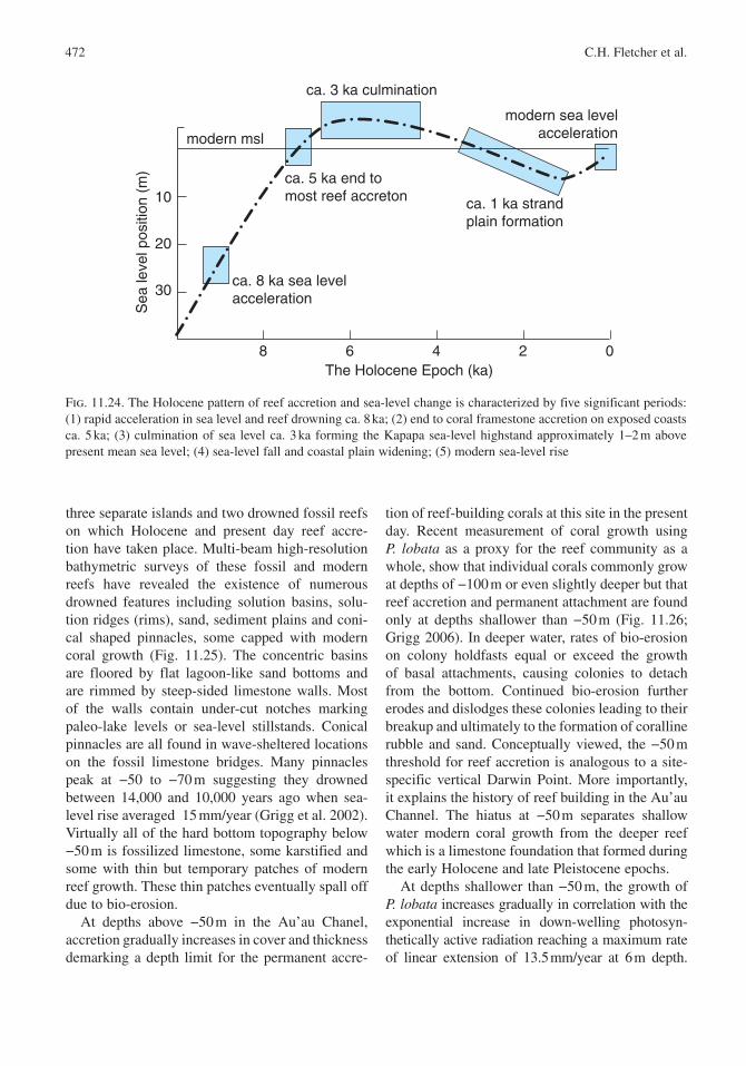
472 C.H. Fletcher et al.
three separate islands and two drowned fossil reefs on which Holocene and present day reef accre-tion have taken place. Multi-beam high-resolution bathymetric surveys of these fossil and modern reefs have revealed the existence of numerous drowned features including solution basins, solu-tion ridges (rims), sand, sediment plains and coni-cal shaped pinnacles, some capped with modern coral growth (Fig. 11.25). The concentric basins are floored by flat lagoon -like sand bottoms and are rimmed by steep-sided limestone walls. Most of the walls contain under-cut notches marking paleo-lake levels or sea-level stillstands. Conical pinnacles are all found in wave-sheltered locations on the fossil limestone bridges. Many pinnacles peak at −50 to −70 m suggesting they drowned between 14,000 and 10,000 years ago when sea-level rise averaged 15 mm/year (Grigg et al. 2002). Virtually all of the hard bottom topography below −50 m is fossilized limestone, some karstified and some with thin but temporary patches of modern reef growth. These thin patches eventually spall off due to bio-erosion.
At depths above −50 m in the Au’au Chanel, accretion gradually increases in cover and thickness demarking a depth limit for the permanent accre-
tion of reef-building corals at this site in the present day. Recent measurement of coral growth using P. lobata as a proxy for the reef community as a whole, show that individual corals commonly grow at depths of −100 m or even slightly deeper but that reef accretion and permanent attachment are found only at depths shallower than −50 m (Fig. 11.26; Grigg 2006). In deeper water, rates of bio-erosion on colony holdfasts equal or exceed the growth of basal attachments, causing colonies to detach from the bottom. Continued bio-erosion further erodes and dislodges these colonies leading to their breakup and ultimately to the formation of coralline rubble and sand. Conceptually viewed, the −50 m threshold for reef accretion is analogous to a site-specific vertical Darwin Point. More importantly, it explains the history of reef building in the Au’au Channel. The hiatus at −50 m separates shallow water modern coral growth from the deeper reef which is a limestone foundation that formed during the early Holocene and late Pleistocene epochs.
At depths shallower than −50 m, the growth of P. lobata increases gradually in correlation with the exponential increase in down-welling photosyn-thetically active radiation reaching a maximum rate of linear extension of 13.5 mm/year at 6 m depth.
10
20
30
8 6 4 2 0
modern msl
ca. 3 ka culmination
ca. 5 ka end tomost reef accreton
ca. 8 ka sea levelacceleration
modern sea levelacceleration
ca. 1 ka strandplain formation
The Holocene Epoch (ka)
Sea
leve
l pos
ition
(m
)
Fig. 11.24. The Holocene pattern of reef accretion and sea-level change is characterized by five significant periods: (1) rapid acceleration in sea level and reef drowning ca. 8 ka; (2) end to coral framestone accretion on exposed coasts ca. 5 ka; (3) culmination of sea level ca. 3 ka forming the Kapapa sea-level highstand approximately 1–2 m above present mean sea level; (4) sea-level fall and coastal plain widening; (5) modern sea-level rise
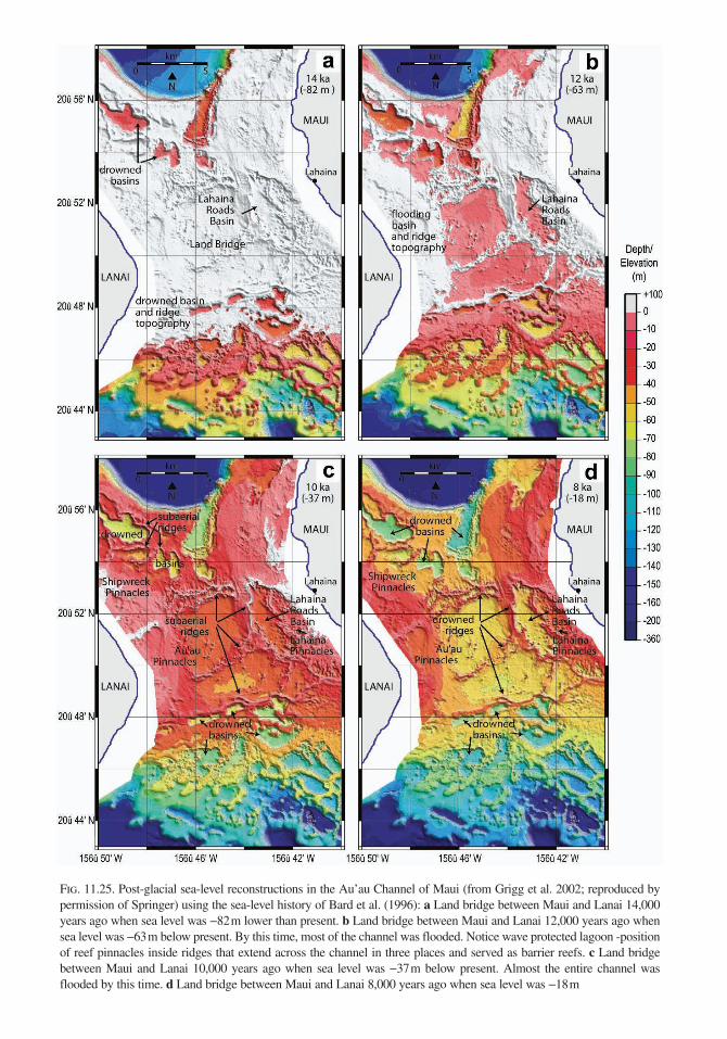
Fig. 11.25. Post-glacial sea-level reconstructions in the Au’au Channel of Maui (from Grigg et al. 2002; reproduced by permission of Springer) using the sea-level history of Bard et al. (1996): a Land bridge between Maui and Lanai 14,000 years ago when sea level was −82 m lower than present. b Land bridge between Maui and Lanai 12,000 years ago when sea level was −63 m below present. By this time, most of the channel was flooded. Notice wave protected lagoon - position of reef pinnacles inside ridges that extend across the channel in three places and served as barrier reefs. c Land bridge between Maui and Lanai 10,000 years ago when sea level was −37 m below present. Almost the entire channel was flooded by this time. d Land bridge between Maui and Lanai 8,000 years ago when sea level was −18 m
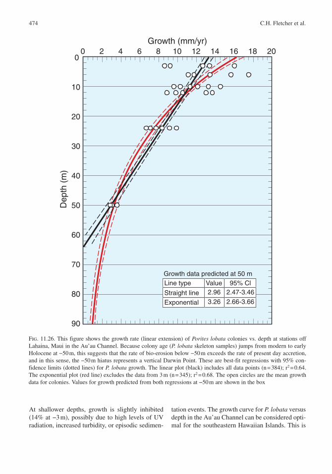
474 C.H. Fletcher et al.
At shallower depths, growth is slightly inhibited (14% at −3 m), possibly due to high levels of UV radiation, increased turbidity , or episodic sedimen-
tation events. The growth curve for P. lobata versus depth in the Au’au Channel can be considered opti-mal for the southeastern Hawaiian Islands . This is
0 2 4 6 8 10 12 14 16 18 20
90
80
70
60
50
40
30
20
10
0
Growth (mm/yr)
Dep
th (
m)
Line type
Straight line
Exponential
2.47-3.46
2.66-3.66
2.9695% ClValue
3.26
Growth data predicted at 50 m
Fig. 11.26. This figure shows the growth rate (linear extension) of Porites lobata colonies vs. depth at stations off Lahaina, Maui in the Au’au Channel. Because colony age (P. lobata skeleton samples) jumps from modern to early Holocene at −50 m, this suggests that the rate of bio-erosion below −50 m exceeds the rate of present day accretion, and in this sense, the −50 m hiatus represents a vertical Darwin Point. These are best-fit regressions with 95% con-fidence limits (dotted lines) for P. lobata growth. The linear plot (black) includes all data points (n = 384); r2 = 0.64. The exponential plot (red line) excludes the data from 3 m (n = 345); r2 = 0.68. The open circles are the mean growth data for colonies. Values for growth predicted from both regressions at −50 m are shown in the box
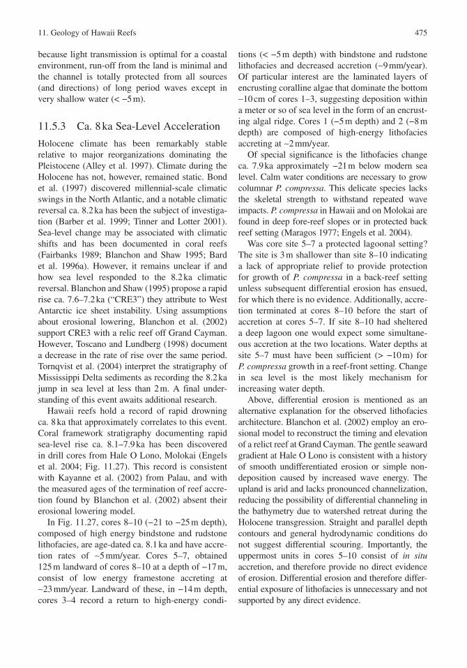
11. Geology of Hawaii Reefs 475
because light transmission is optimal for a coastal environment, run-off from the land is minimal and the channel is totally protected from all sources (and directions) of long period waves except in very shallow water (< −5 m).
11.5.3 Ca. 8 ka Sea-Level Acceleration
Holocene climate has been remarkably stable relative to major reorganizations dominating the Pleistocene (Alley et al. 1997). Climate during the Holocene has not, however, remained static. Bond et al. (1997) discovered millennial-scale climatic swings in the North Atlantic , and a notable climatic reversal ca. 8.2 ka has been the subject of investiga-tion (Barber et al. 1999; Tinner and Lotter 2001). Sea-level change may be associated with climatic shifts and has been documented in coral reefs (Fairbanks 1989; Blanchon and Shaw 1995; Bard et al. 1996a). However, it remains unclear if and how sea level responded to the 8.2 ka climatic reversal. Blanchon and Shaw (1995) propose a rapid rise ca. 7.6–7.2 ka (“CRE3”) they attribute to West Antarctic ice sheet instability. Using assumptions about erosional lowering, Blanchon et al. (2002) support CRE3 with a relic reef off Grand Cayman . However, Toscano and Lundberg (1998) document a decrease in the rate of rise over the same period. Tornqvist et al. (2004) interpret the stratigraphy of Mississippi Delta sediments as recording the 8.2 ka jump in sea level at less than 2 m. A final under-standing of this event awaits additional research.
Hawaii reefs hold a record of rapid drowning ca. 8 ka that approximately correlates to this event. Coral framework stratigraphy documenting rapid sea-level rise ca. 8.1–7.9 ka has been discovered in drill cores from Hale O Lono , Molokai (Engels et al. 2004; Fig. 11.27). This record is consistent with Kayanne et al. (2002) from Palau , and with the measured ages of the termination of reef accre-tion found by Blanchon et al. (2002) absent their erosional lowering model.
In Fig. 11.27, cores 8–10 (−21 to −25 m depth), composed of high energy bindstone and rudstone lithofacies, are age-dated ca. 8.1 ka and have accre-tion rates of ∼5 mm/year. Cores 5–7, obtained 125 m landward of cores 8–10 at a depth of −17 m, consist of low energy framestone accreting at ∼23 mm/year. Landward of these, in −14 m depth, cores 3–4 record a return to high-energy condi-
tions (< −5 m depth) with bindstone and rudstone lithofacies and decreased accretion (∼9 mm/year). Of particular interest are the laminated layers of encrusting coralline algae that dominate the bottom ∼10 cm of cores 1–3, suggesting deposition within a meter or so of sea level in the form of an encrust-ing algal ridge. Cores 1 (−5 m depth) and 2 (−8 m depth) are composed of high-energy lithofacies accreting at ∼2 mm/year.
Of special significance is the lithofacies change ca. 7.9 ka approximately −21 m below modern sea level. Calm water conditions are necessary to grow columnar P. compressa. This delicate species lacks the skeletal strength to withstand repeated wave impacts. P. compressa in Hawaii and on Molokai are found in deep fore-reef slopes or in protected back reef setting (Maragos 1977; Engels et al. 2004).
Was core site 5–7 a protected lagoonal setting? The site is 3 m shallower than site 8–10 indicating a lack of appropriate relief to provide protection for growth of P. compressa in a back-reef setting unless subsequent differential erosion has ensued, for which there is no evidence. Additionally, accre-tion terminated at cores 8–10 before the start of accretion at cores 5–7. If site 8–10 had sheltered a deep lagoon one would expect some simultane-ous accretion at the two locations. Water depths at site 5–7 must have been sufficient (> −10 m) for P. compressa growth in a reef-front setting. Change in sea level is the most likely mechanism for increasing water depth.
Above, differential erosion is mentioned as an alternative explanation for the observed lithofacies architecture. Blanchon et al. (2002) employ an ero-sional model to reconstruct the timing and elevation of a relict reef at Grand Cayman . The gentle seaward gradient at Hale O Lono is consistent with a history of smooth undifferentiated erosion or simple non-deposition caused by increased wave energy . The upland is arid and lacks pronounced channelization, reducing the possibility of differential channeling in the bathymetry due to watershed retreat during the Holocene transgression . Straight and parallel depth contours and general hydrodynamic conditions do not suggest differential scouring. Importantly, the uppermost units in cores 5–10 consist of in situ accretion, and therefore provide no direct evidence of erosion. Differential erosion and therefore differ-ential exposure of lithofacies is unnecessary and not supported by any direct evidence.
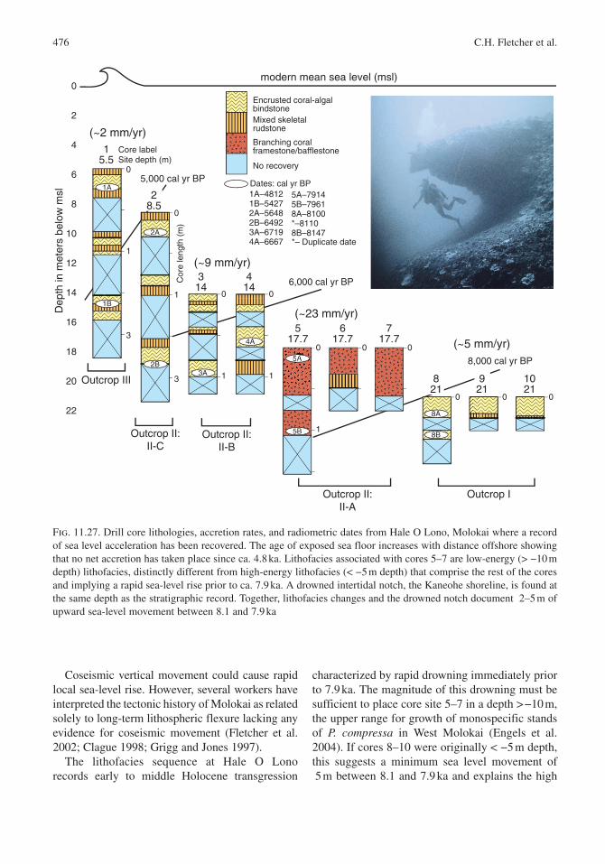
476 C.H. Fletcher et al.
Coseismic vertical movement could cause rapid local sea-level rise. However, several workers have interpreted the tectonic history of Molokai as related solely to long-term lithospheric flexure lacking any evidence for coseismic movement (Fletcher et al. 2002; Clague 1998; Grigg and Jones 1997).
The lithofacies sequence at Hale O Lono records early to middle Holocene transgression
characterized by rapid drowning immediately prior to 7.9 ka. The magnitude of this drowning must be sufficient to place core site 5–7 in a depth > −10 m, the upper range for growth of monospecific stands of P. compressa in West Molokai (Engels et al. 2004). If cores 8–10 were originally < −5 m depth, this suggests a minimum sea level movement of 5 m between 8.1 and 7.9 ka and explains the high
Fig. 11.27. Drill core lithologies, accretion rates, and radiometric dates from Hale O Lono , Molokai where a record of sea level acceleration has been recovered. The age of exposed sea floor increases with distance offshore showing that no net accretion has taken place since ca. 4.8 ka. Lithofacies associated with cores 5–7 are low-energy (> −10 m depth) lithofacies, distinctly different from high-energy lithofacies (< −5 m depth) that comprise the rest of the cores and implying a rapid sea-level rise prior to ca. 7.9 ka. A drowned intertidal notch, the Kaneohe shoreline, is found at the same depth as the stratigraphic record. Together, lithofacies changes and the drowned notch document 2–5 m of upward sea-level movement between 8.1 and 7.9 ka
0
2
4
6
8
10
12
14
16
18
20
22
Dep
th in
met
ers
belo
w m
sl
modern mean sea level (msl)
Outcrop IOutcrop II:II-A
Outcrop II:II-B
Outcrop II:II-C
Outcrop III
Encrusted coral-algalbindstoneMixed skeletalrudstone
Branching coralframestone/bafflestone
No recovery
Dates: cal yr BP1A–48121B–54272A–56482B–64923A–67194A–6667
5A–79145B–79618A–8100*–81108B–8147
15.5
28.5
314
414
517.7
617.7
717.7
821
921
1021
0
1 0
1
0
1
0
1
0 0
0 0 0
3
0
1
3
5,000 cal yr BP
6,000 cal yr BP
8,000 cal yr BP
(~2 mm/yr)
(~9 mm/yr)
(~23 mm/yr)
(~5 mm/yr)
Core labelSite depth (m)
*– Duplicate date
Cor
e le
ngth
(m
)1A
1B
3A
2A
2B
4A
5A
8A
8B5B
11. Geology of Hawaii Reefs 477
accretion rates at cores 5–7 (∼23 mm/year) as the result of a “catch-up” mode of reef growth follow-ing sudden drowning.
This is an important section of the Hawaiian sea-level record because the reef platform at Kailua Bay on Oahu was likely flooded by early Holocene sea-level rise, as was Hanauma Bay (Easton and Olson 1976; Grossman and Fletcher 2004) and by implication other shallow platforms in Hawaii. Notably, this period of time, and the position of sea level, is consistent with the preservation of a dis-tinct drowned notch ringing Oahu at −18 to −25 m depth, the “Kaneohe Shoreline ”, mentioned earlier and interpreted by Fletcher and Sherman (1995) and first named by Stearns (1978). Good preserva-tion of the notch visor suggests that sea level rose upward out of the notch at a high rate (Pirazzoli 1986) – correlating with the core record from Molokai . As pointed out in Fletcher and Sherman (1995), this period is consistent with the timing identified for the breakout of Laurentide glacial lakes (Dyke and Prest 1987; Barber et al. 1999). The Hale O Lono , Molokai record, and a similar record in Palau (Kayanne et al. 2002), suggests that forcing of the cold event ca. 8.2 ka by catastrophic drainage of Laurentide lakes was accompanied by a sea-level response with global impact.
11.5.4 Ca. 5 ka End of Widespread Framework Accretion
The most detailed core sampling of Holocene reef accretion on Oahu comes from two studies: (1) Easton and Olson (1976) who cored protected Hanauma Bay fringing reef, reviewed and inte-grated with data from elsewhere on the island by Grigg (1998) and (2) Grossman (2001) and Grossman and Fletcher (2004) who cored Kailua Bay, open to trade wind seas and refracting north swell . The Hanauma Bay research was seminal and has become a classic work among the litera-ture on Holocene reefs. Kailua Bay results benefit from improvements in dating technology and more attention paid to analyzing cored lithofacies in light of paleo-sea level position.
Grossman and Fletcher (2004) report on cored lithofacies in Kailua Bay. Corals are entirely aragonite and coralline algae exhibit the normal range of 15–19 mole% MgCO3. Occasionally, coralline algae encrust interskeletal coral cavities
that may also be partly infilled with magnesium-calcite microcrystalline cement (rarely exceeding 2% by weight of total CaCO3). Massive peloidal micrites, grain coatings, and void lining cements of magnesium-calcite characterize most cements and aragonite cement is rare. It is restricted to interskeletal coral cavities where it occurs as thin acicular fibrous needles. The most abundant cement is massive peloidal micrite characterized by knobby club-shaped columns ranging 0.1–1 cm in height. These often occur immediately above laminar crusts, creating thick (2–20 cm) sequences of massive lithified peloidal micrite. Comprising a major portion of branching framestones, mic-rite characterizes internal sediment trapped within inter-and intraskeletal cavities and significantly reduces porosity.
At Kailua , early Holocene accretion ca. 8–6 ka, approximately 14–24 m below sea level, is typi-cally restricted to the reef front or paleochannels below wave base. Mixtures of encrusting and massive forms of P. lobata colonized sandy and rudstone substrate or the antecedent Waianae Reef surface. One long core from the outer reef at Kailua records 3–4 m of massive growth until ca. 6.5 ka succeeded by branching colonies of P. compressa that accreted another 7.5 m to ca. 5.3 ka.
Middle Holocene accretion is more complex and reflects the role of several processes. Because of Kailua ’s partially exposed/partially protected orientation to damaging north swell , it is diffi-cult to definitively isolate controlling influences on reef development . Accretion in this period is less common in Kailua and characterized by a shift from widespread framestone development in topographically low areas to localized algal ridges , rudstone pavements, and spotty framestone accre-tion. These localized patterns typically developed over the period ca. 4.7–3.2 ka, with thicknesses of only 1–2 m. Grossman and Fletcher (2004) con-clude that the highest rates of accretion correlate with in situ framestone accretion during the early middle Holocene when sea level was rising more than 2–3 mm/year (or faster). As sea-level rise slowed, accretion also slowed, but persisted (in the form of rudstone accumulation) at 1–2 mm/year even as sea-level fell at 1.5–2.0 mm/year following the Kapapa highstand .
Alternatively, Rooney et al. (2004) examined a data set of reef growth in more exposed settings
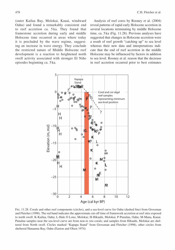
478 C.H. Fletcher et al.
(outer Kailua Bay, Molokai , Kauai , windward Oahu ) and found a remarkably consistent end to reef accretion ca. 5 ka. They found that framestone accretion during early and middle Holocene time occurred in areas where today it is precluded by the wave regime, suggest-ing an increase in wave energy . They conclude the restricted nature of Middle Holocene reef development is a reaction to heightened north swell activity associated with stronger El Niño episodes beginning ca. 5 ka.
Analysis of reef cores by Rooney et al. (2004) reveal patterns of rapid early Holocene accretion in several locations terminating by middle Holocene time, ca. 5 ka (Fig. 11.28). Previous analyses have suggested that changes in Holocene accretion were a result of reef growth “catching up” to sea level whereas their new data and interpretations indi-cate that the end of reef accretion in the middle Holocene may be influenced by factors in addition to sea level. Rooney et al. reason that the decrease in reef accretion occurred prior to best estimates
0 2 4 6 8 10 12
Age (cal kyr BP)
−30
−25
−20
−15
−10
−5
0
5
Elev
atio
n (m
, msl
)
K
K
K
K
K
K
K
K
L L
L
L
L
H
H
H
H
H H
H H
P
P P
P
P P P P
M
M M
M M M
M
?
?
?
Coral and cor-algal reef samples representing minimum sea-level position
Kapapa Stand
Fig. 11.28. Corals and other reef components (circles), and a sea-level curve for Oahu (dashed line) from Grossman and Fletcher (1998). The red band indicates the approximate cut-off time of framework accretion at reef sites exposed to north swell . K-Kailua , Oahu; L-Hale O Lono , Molokai ; H-Hikauhi, Molokai; P-Punaluu, Oahu; M-Mana, Kauai . Punaluu samples near the sea-level curve are from non-in situ corals; and samples from Hikauhi, Molokai are shel-tered from North swell. Circles marked “Kapapa Stand” from Grossman and Fletcher (1998), other circles from sheltered Hanauma Bay , Oahu (Easton and Olsen 1974)
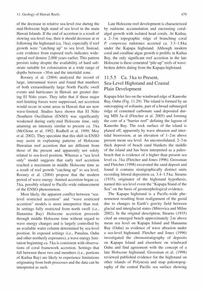
11. Geology of Hawaii Reefs 479
of the decrease in relative sea-level rise during the mid-Holocene high stand of sea level in the main Hawaii Islands. If the end of accretion is a result of slowing sea-level rise, then it should decrease at or following the highstand (ca. 3 ka), especially if reef growth were “catching up” to sea level. Instead, core evidence from exposed reefs indicates wide-spread reef demise 2,000 years earlier. This pattern persists today despite the availability of hard sub-strate suitable for colonization at a wide range of depths between −30 m and the intertidal zone.
Rooney et al. (2004) analyzed the record of large, interannual waves and found that numbers of both extraordinarily large North Pacific swell events and hurricanes in Hawaii are greater dur-ing El Niño years. They infer that if these major reef-limiting forces were suppressed, net accretion would occur in some areas in Hawaii that are now wave-limited. Studies have shown that El Niño /Southern Oscillation (ENSO ) was significantly weakened during early-mid Holocene time, only attaining an intensity similar to present ca. 5 ka (McGlone et al. 1992; Rodbell et al. 1999; Moy et al. 2002). They speculate that this shift in ENSO may assist in explaining patterns of Holocene Hawaiian reef accretion that are different from those of the present and apparently not solely related to sea-level position. Whereas a “sea level only” model suggests that early reef accretion reached a maximum in middle Holocene time as a result of reef growth “catching up” to sea level, Rooney et al. (2004) propose that the modern period of wave energy -limited accretion began ca. 5 ka, possibly related to Pacific-wide enhancement of the ENSO phenomenon.
Most likely, the apparent conflict between “sea-level restricted accretion” and “wave restricted accretion” models is more interpretive than real. In settings fully restricted from north swell (i.e., Hanauma Bay ) Holocene accretion proceeds through middle Holocene time without regard to wave energy changes and is largely controlled by an available water column determined by sea-level position. In exposed settings (i.e., Punaluu, Oahu and other northerly exposures), a wave energy limi-tation beginning ca. 5 ka is consistent with observa-tions of coral framework accretion. Settings that fall between these two end members (i.e., portions of Kailua Bay) are likely to experience limitations originating from both processes and the data can be interpreted as such.
Late Holocene reef development is characterized by rudstone accumulation and encrusting coral-algal growth with isolated head corals. At Kailua , a 2–3 m topographic ridge of branching coral P. compressa rudstones accreted ca. 3.3–1.8 ka under the Kapapa highstand . Although modern coral and coralline algae growth is prolific in Kailua Bay, the only significant reef accretion in the late Holocene is these cemented “pile-up” reefs of wave-broken debris dating from the Kapapa highstand.
11.5.5 Ca. 3 ka to Present, Sea-Level Highstand and Coastal Plain Development
Kapapa Islet lies on the windward edge of Kaneohe Bay , Oahu (Fig. 11.29). The island is formed by an outcropping of eolianite , part of a broad submerged ridge of cemented carbonate sand deposited dur-ing MIS 5a–d (Fletcher et al. 2005) and forming the core of a “barrier reef ” defining the lagoon of Kaneohe Bay. The rock surface of the island is planed off, apparently by wave abrasion and inter-tidal bioerosion , at an elevation of 1–2 m above present mean sea level. An unconsolidated, 2–3 m thick deposit of beach sand blankets the middle of the island and has been interpreted as a paleo-beach that is evidence of a higher than present sea level ca. 3 ka (Fletcher and Jones 1996). Grossman and Fletcher (1998) excavated the sand deposit and found it contains stratigraphically distinct units recording littoral deposition ca. 3.4–1.5 ka. Stearns (1935), originator of the highstand hypothesis, named this sea level event the “Kapapa Stand of the Sea” on the basis of geomorphological evidence.
The Kapapa highstand is a Pacific-wide phe-nomenon resulting from realignment of the geoid due to changes in Earth’s gravity field between glacial and interglacial states (Mitrovica and Milne 2002). In the original description, Stearns (1935) cited an emerged bench approximately 2 m above mean sea level on Kapapa Island and Hanauma Bay (Oahu ) as evidence of wave abrasion under a sea-level highstand. Fletcher and Jones (1996) investigated the chronostratigraphy of deposits on Kapapa Island and elsewhere on windward Oahu and find agreement with the concept of a late Holocene highstand. Grossman et al. (1998) reviewed published evidence for the highstand on other islands of Polynesia and map paleotopog-raphy of the central Pacific sea surface showing
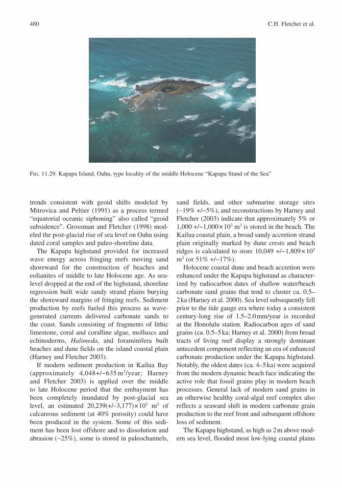
480 C.H. Fletcher et al.
trends consistent with geoid shifts modeled by Mitrovica and Peltier (1991) as a process termed “equatorial oceanic siphoning” also called “geoid subsidence ”. Grossman and Fletcher (1998) mod-eled the post-glacial rise of sea level on Oahu using dated coral samples and paleo-shoreline data.
The Kapapa highstand provided for increased wave energy across fringing reefs moving sand shoreward for the construction of beaches and eolianites of middle to late Holocene age. As sea-level dropped at the end of the highstand, shoreline regression built wide sandy strand plains burying the shoreward margins of fringing reefs. Sediment production by reefs fueled this process as wave-generated currents delivered carbonate sands to the coast. Sands consisting of fragments of lithic limestone, coral and coralline algae , molluscs and echinoderms , Halimeda, and foraminifera built beaches and dune fields on the island coastal plain (Harney and Fletcher 2003).
If modern sediment production in Kailua Bay (approximately 4,048+/−635 m3/year; Harney and Fletcher 2003) is applied over the middle to late Holocene period that the embayment has been completely inundated by post-glacial sea level, an estimated 20,239(+/–3,177) × 103 m3 of calcareous sediment (at 40% porosity) could have been produced in the system. Some of this sedi-ment has been lost offshore and to dissolution and abrasion (∼25%), some is stored in paleochannels,
sand fields, and other submarine storage sites (∼19% +/−5%), and reconstructions by Harney and Fletcher (2003) indicate that approximately 5% or 1,000 +/−1,000 × 103 m3 is stored in the beach. The Kailua coastal plain, a broad sandy accretion strand plain originally marked by dune crests and beach ridges is calculated to store 10,049 +/−1,809 × 103 m3 (or 51% +/−17%).
Holocene coastal dune and beach accretion were enhanced under the Kapapa highstand as character-ized by radiocarbon dates of shallow water/beach carbonate sand grains that tend to cluster ca. 0.5–2 ka (Harney et al. 2000). Sea level subsequently fell prior to the tide gauge era where today a consistent century-long rise of 1.5–2.0 mm/year is recorded at the Honolulu station. Radiocarbon ages of sand grains (ca. 0.5–5 ka; Harney et al. 2000) from broad tracts of living reef display a strongly dominant antecedent component reflecting an era of enhanced carbonate production under the Kapapa highstand. Notably, the oldest dates (ca. 4–5 ka) were acquired from the modern dynamic beach face indicating the active role that fossil grains play in modern beach processes. General lack of modern sand grains in an otherwise healthy coral-algal reef complex also reflects a seaward shift in modern carbonate grain production to the reef front and subsequent offshore loss of sediment .
The Kapapa highstand , as high as 2 m above mod-ern sea level, flooded most low-lying coastal plains
Fig. 11.29. Kapapa Island, Oahu , type locality of the middle Holocene “Kapapa Stand of the Sea”
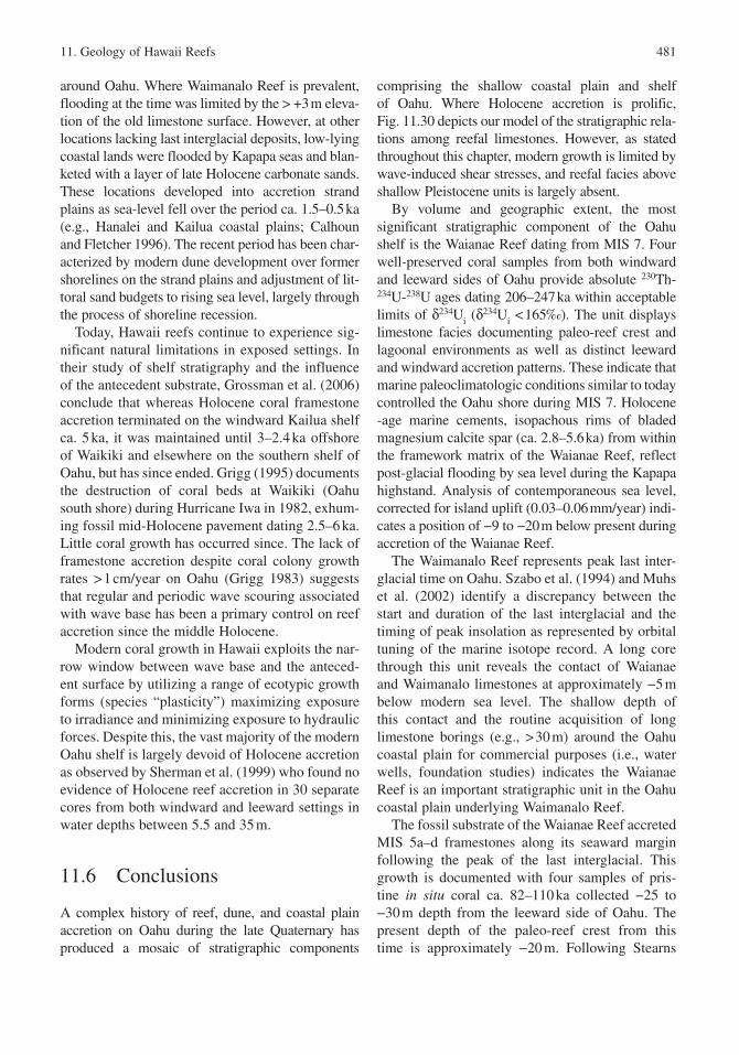
11. Geology of Hawaii Reefs 481
around Oahu . Where Waimanalo Reef is prevalent, flooding at the time was limited by the > +3 m eleva-tion of the old limestone surface. However, at other locations lacking last interglacial deposits, low-lying coastal lands were flooded by Kapapa seas and blan-keted with a layer of late Holocene carbonate sands. These locations developed into accretion strand plains as sea-level fell over the period ca. 1.5–0.5 ka (e.g., Hanalei and Kailua coastal plains; Calhoun and Fletcher 1996). The recent period has been char-acterized by modern dune development over former shorelines on the strand plains and adjustment of lit-toral sand budgets to rising sea level, largely through the process of shoreline recession.
Today, Hawaii reefs continue to experience sig-nificant natural limitations in exposed settings. In their study of shelf stratigraphy and the influence of the antecedent substrate, Grossman et al. (2006) conclude that whereas Holocene coral framestone accretion terminated on the windward Kailua shelf ca. 5 ka, it was maintained until 3–2.4 ka offshore of Waikiki and elsewhere on the southern shelf of Oahu , but has since ended. Grigg (1995) documents the destruction of coral beds at Waikiki (Oahu south shore) during Hurricane Iwa in 1982, exhum-ing fossil mid-Holocene pavement dating 2.5–6 ka. Little coral growth has occurred since. The lack of framestone accretion despite coral colony growth rates > 1 cm/year on Oahu (Grigg 1983) suggests that regular and periodic wave scouring associated with wave base has been a primary control on reef accretion since the middle Holocene.
Modern coral growth in Hawaii exploits the nar-row window between wave base and the anteced-ent surface by utilizing a range of ecotypic growth forms (species “plasticity”) maximizing exposure to irradiance and minimizing exposure to hydraulic forces. Despite this, the vast majority of the modern Oahu shelf is largely devoid of Holocene accretion as observed by Sherman et al. (1999) who found no evidence of Holocene reef accretion in 30 separate cores from both windward and leeward settings in water depths between 5.5 and 35 m.
11.6 Conclusions
A complex history of reef, dune , and coastal plain accretion on Oahu during the late Quaternary has produced a mosaic of stratigraphic components
comprising the shallow coastal plain and shelf of Oahu. Where Holocene accretion is prolific, Fig. 11.30 depicts our model of the stratigraphic rela-tions among reefal limestones. However, as stated throughout this chapter, modern growth is limited by wave-induced shear stresses, and reefal facies above shallow Pleistocene units is largely absent.
By volume and geographic extent, the most significant stratigraphic component of the Oahu shelf is the Waianae Reef dating from MIS 7. Four well-preserved coral samples from both windward and leeward sides of Oahu provide absolute 230Th-234U-238U ages dating 206–247 ka within acceptable limits of δ234Ui (δ
234Ui < 165‰). The unit displays limestone facies documenting paleo-reef crest and lagoonal environments as well as distinct leeward and windward accretion patterns. These indicate that marine paleoclimatologic conditions similar to today controlled the Oahu shore during MIS 7. Holocene -age marine cements, isopachous rims of bladed magnesium calcite spar (ca. 2.8–5.6 ka) from within the framework matrix of the Waianae Reef, reflect post-glacial flooding by sea level during the Kapapa highstand . Analysis of contemporaneous sea level, corrected for island uplift (0.03–0.06 mm/year) indi-cates a position of −9 to −20 m below present during accretion of the Waianae Reef.
The Waimanalo Reef represents peak last inter-glacial time on Oahu . Szabo et al. (1994) and Muhs et al. (2002) identify a discrepancy between the start and duration of the last interglacial and the timing of peak insolation as represented by orbital tuning of the marine isotope record. A long core through this unit reveals the contact of Waianae and Waimanalo limestones at approximately −5 m below modern sea level. The shallow depth of this contact and the routine acquisition of long limestone borings (e.g., > 30 m) around the Oahu coastal plain for commercial purposes (i.e., water wells, foundation studies) indicates the Waianae Reef is an important stratigraphic unit in the Oahu coastal plain underlying Waimanalo Reef.
The fossil substrate of the Waianae Reef accreted MIS 5a–d framestones along its seaward margin following the peak of the last interglacial . This growth is documented with four samples of pris-tine in situ coral ca. 82–110 ka collected −25 to −30 m depth from the leeward side of Oahu . The present depth of the paleo-reef crest from this time is approximately −20 m. Following Stearns
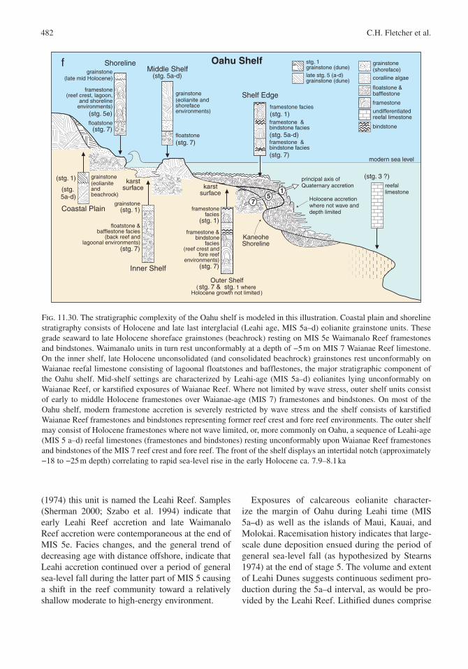
482 C.H. Fletcher et al.
(1974) this unit is named the Leahi Reef. Samples (Sherman 2000; Szabo et al. 1994) indicate that early Leahi Reef accretion and late Waimanalo Reef accretion were contemporaneous at the end of MIS 5e. Facies changes, and the general trend of decreasing age with distance offshore, indicate that Leahi accretion continued over a period of general sea-level fall during the latter part of MIS 5 causing a shift in the reef community toward a relatively shallow moderate to high-energy environment.
Exposures of calcareous eolianite character-ize the margin of Oahu during Leahi time (MIS 5a–d) as well as the islands of Maui, Kauai , and Molokai . Racemisation history indicates that large-scale dune deposition ensued during the period of general sea-level fall (as hypothesized by Stearns 1974) at the end of stage 5. The volume and extent of Leahi Dunes suggests continuous sediment pro-duction during the 5a–d interval, as would be pro-vided by the Leahi Reef. Lithified dunes comprise
Outer Shelf( stg. 7 & stg. 1 where
Holocene growth not limited )
ShorelineMiddle Shelf
(stg. 5a-d)
Shelf Edge
(stg. 3 ?)
Inner Shelf
Coastal Plain
framestone(reef crest, lagoon,
and shorelineenvironments)
(stg. 5e)
grainstone (eolianite andshorefaceenvironments)
framestone facies(stg. 1)framestone &bindstone facies(stg. 5a-d)framestone &bindstone facies(stg. 7)
Holocene accretion where not wave anddepth limited
karstsurface
floatstone &bafflestone facies
(back reef andlagoonal environments)
(stg. 7)
grainstone(stg. 1)
grainstone(late mid Holocene)
floatstone(stg. 7)
floatstone(stg. 7)
grainstone(eolianite andbeachrock)
reefallimestone
(stg. 1)
(stg. 5a-d)
f
modern sea level
principal axis ofQuaternary accretion
framestonefacies
(stg. 1)
framestone &bindstone
facies(reef crest and
fore reefenvironments)
(stg. 7)
karstsurface
7
15
bindstone
late stg. 5 (a-d)grainstone (dune)
grainstone (shoreface)
coralline algae
floatstone &bafflestone
framestone
undifferentiatedreefal limestone
stg. 1 grainstone (dune)
KaneoheShoreline
Oahu Shelf
Fig. 11.30. The stratigraphic complexity of the Oahu shelf is modeled in this illustration. Coastal plain and shoreline stratigraphy consists of Holocene and late last interglacial (Leahi age, MIS 5a–d) eolianite grainstone units. These grade seaward to late Holocene shoreface grainstones (beachrock) resting on MIS 5e Waimanalo Reef framestones and bindstones. Waimanalo units in turn rest unconformably at a depth of −5 m on MIS 7 Waianae Reef limestone. On the inner shelf, late Holocene unconsolidated (and consolidated beachrock) grainstones rest unconformably on Waianae reefal limestone consisting of lagoonal floatstones and bafflestones, the major stratigraphic component of the Oahu shelf. Mid-shelf settings are characterized by Leahi-age (MIS 5a–d) eolianites lying unconformably on Waianae Reef, or karstified exposures of Waianae Reef. Where not limited by wave stress, outer shelf units consist of early to middle Holocene framestones over Waianae-age (MIS 7) framestones and bindstones. On most of the Oahu shelf, modern framestone accretion is severely restricted by wave stress and the shelf consists of karstified Waianae Reef framestones and bindstones representing former reef crest and fore reef environments. The outer shelf may consist of Holocene framestones where not wave limited, or, more commonly on Oahu, a sequence of Leahi-age (MIS 5 a–d) reefal limestones (framestones and bindstones) resting unconformably upon Waianae Reef framestones and bindstones of the MIS 7 reef crest and fore reef. The front of the shelf displays an intertidal notch (approximately −18 to −25 m depth) correlating to rapid sea-level rise in the early Holocene ca. 7.9–8.1 ka
11. Geology of Hawaii Reefs 483
significant stratigraphic members of the subaerial coastal plain and they are important components of the shallow submerged shelf. In places, they form a substrate for Holocene coral growth in the form of a major “barrier reef ” (Kaneohe Bay ) and multiple offshore islets (e.g., Kapapa Island).
Long-term flexural uplift of Oahu coupled with heavy wave stress and reduced accommodation space above the Pleistocene surface placed severe natural limitations on Holocene and modern reef accretion . Most modern accretion occurs on the front, deep (−10 to −30 m) slope of the Pleistocene shelf where ambient light and nutrient levels permit coral growth in areas protected from wave stress. Other accretion centers are found infilling paleo-channels and other types of protected environments such as the Au’au Channel. Holocene framework is largely a veneer on the wave-scoured shallow surface of the shelf.
Reefal limestones sampled from earliest Holocene time date ca. 7.9–8.1 ka at depths of approximately −18 to −25 m. These include mostly delicate branching framework corals that grade upward to encrusting algae and stout coral assem-blages reflecting shallowing conditions. A major “jump” in sea level at this time produced a drowned shoreline in the islands (a submerged intertidal notch) and a stratigraphic record of sudden drown-ing of a fringing reef crest facies .
The majority of Holocene coral framework accre-tion terminated ca. 5 ka on Oahu . Middle Holocene reef accretion is uncommon in exposed regions and characterized by a shift from widespread frame-stone development in topographically low areas to localized algal ridges , rudstone pavements, and spotty framestone accretion. These localized accre-tion patterns typically developed ca. 4.7–3.2 ka, with thicknesses of only 1–2 m. Late Holocene reef development is characterized by rudstone accu-mulations and encrusting coral-algal growth with isolated head corals. The late Holocene Kapapa highstand was a time of Holocene rudstone accu-mulation on reef flats termed “pile-up” reefs. The post highstand fall of sea level produced regression strand plains composed of middle to late Holocene-age sands. These sandy coastal plains are fronted by beaches that rely heavily on fossil sand stores from late Holocene highstand production rather than modern sand production.
In conclusion, the stratigraphic and environ-mental complexity of the Oahu shelf has produced
severe limitations on accommodation space for continued coral framework accretion. Flexural uplift of Oahu, the shallow antecedent surface, and wide-spread high wave stress presently limit modern reef accretion which in turn restricts carbonate sand production. This geologic history therefore inhibits the ability of the existing Oahu coral communities to withstand future negative environmental factors such as sedimentation, localized eutrophication, and other types of human impacts. Much of the modern coral growth observed on the shelf (i.e., coral heads, stout branching forms, etc.) is attached to an ancient limestone pavement ranging in age ca. 200–5 ka. This implies that most modern growth is temporary, constantly inhibited or removed by the large energy events that regularly sweep the shelf, and the time for widespread reef accretion has largely passed other than in isolated and protected settings.
Acknowledgements The authors extend sincere appreciation for research funding to the National Geographic Society, the Office of Naval Research, the US Geological Survey Coastal and Marine Geology Program, the National Science Foundation Earth Systems History (ESH) Program, the Sea Grant College of Hawaii, the NOAA Coastal Services Center, the Hawaii Department of Land and Natural Resources, the NOAA Hawaii Coral Reef Initiative Research Program, The US Army Corps of Engineers, and the Khaled bin Sultan Living Oceans Foundation. We especially acknowledge the hard work of the following individuals for assistance in field, laboratory work, and stimulating discussion: Dolan Eversole, Matt Barbee, Chyn Lim, Captains Alan Weaver and Joe Reich, Jane Schoonmaker, Scott Calhoun, Bruce Richmond, Abby Sallenger, Gordon Tribble, and Mike Field.
References
Adey WH (1986) Coralline algae as indicators of sea level. In: Van de Plassche O (ed) Sea Level Research. Geo Books, Norwich, pp 229–280
Alley RB, Mayewski PA, Sowers T, Stuiver M, Taylor KC, Clark PU (1997) Holocene climatic instability: a prominent, widespread event 8200 yr ago. Geology 25:483–486
Barber DC, Dyke A, Hillaire-Marcel C, Jennings AE, Andrews JT, Kerwin MW, Bilodeau G, McNeely
484 C.H. Fletcher et al.
R, Southon J, Morehead MD, Gagnon J-M (1999) Forcing of the cold event of 8,200 years ago by catastrophic drainage of Laurentide lakes. Nature 400:344–348
Bard E, Hamelin B, Arnold M, Montaggioni L, Cabioch G, Faure G, Rougerie F (1996a) Deglacial sea-level record from Tahiti corals and the timing of global meltwater discharge. Nature :382:241–244
Bard E, Jouannic C, Hamelin B, Pirazzoli P, Arnold M, Faure G, Sumosusastro P, Syaefudin C (1996b) Pleistocene sea levels and tectonic uplift based on dat-ing of corals from Sumba Island, Indonesia. Geophys Res Lett 23:1473–1476
Bassinot FC, Labeyrie LD, Vincent E, Quidelleur X, Shackleton NJ, Lancelot Y (1994) The astronomical theory of climate and the age of the Brunhes-Matuyama magnetic reversal. Earth Planet Sci Lett 126:91–108
Blanchon P, Shaw J (1995) Reef drowning during the last deglaciation : evidence for catastrophic sea-level rise and ice-sheet collapse. Geology :4–8
Blanchon P, Jones B, Ford DC (2002) Discovery of a submerged relic reef and shoreline off Grand Cayman : further support for an early Holocene jump in sea level. Sediment Geol 147:253–270
Bond G, Showers W, Cheseby M, Lotti R, Almasi P, deMenocal P, Priore P, Cullen H, Hajdas I, Bonani G (1997) A pervasive millennial-scale cycle in North-Atlantic Holocene and glacial climates. Science 278:1257–1266
Cabioch G, Montaggioni LF, Faure G, Ribaud-Laurenti A(1999) Reef coralgal assemblages as recorders of paleobathymetry and sea level changes in the Indo-Pacific province. Quat Sci Rev 18:1681–1695
Cacchione D, Richmond B, Fletcher C, Tate G, Ferreira J (1999) Sand transport in a reef channel off Kailua , Oahu , Hawaii. In: Fletcher C, Matthews J (eds) The Non-Steady State of the Inner Shelf and Shoreline: Coastal Change on the Time Scale of Decades to Millennia in the Late Quaternary , Abstracts with Programs, IGCP Project #437. University of Hawaii, Honolulu, HI, ,pp 42
Calhoun RS, Fletcher CH (1996) Late Holocene coastal plain stratigraphy and sea level history at Hanalei, Kauai , Hawaii Islands. Quat Res 45:47–58
Chappell J, Shackleton NJ (1986) Oxygen isotopes and sea level. Nature 324:137–140
Chen JH, Edwards RL, Wasserburg GL (1986) 238U, 234U and 232Th in seawater. Earth Planet Sci Lett :241–251
Chen JH, Curran HA, White B, Wasserburg GJ (1991) Precise chronology of the last interglacial period: 234U-230Th data from fossil coral reefs in the Bahamas . Bull Geol Soc Am 103 :82–97
Clague DA (1998) Moloka’i and Lanai , . In: Juvik SP, Juvik JO (eds) Atlas of Hawaii, third edi-
tion. ,University of Hawaii Press, Honolulu , HI, pp 11–13
Clague DA, Dalrymple GB (1987) The Hawaii-emperor volcanic chain, part i, geologic evolution. In: Decker RW, Wright TL, Stauffer PH (eds) Volcanism in Hawai‘i. US Geol Surv Prof Pap 1350:5–54.
Conger C (2005) Identification and characterization of sand deposit distribution on the fringing reefs of Oahu , Hawaii, M.S. thesis, University of Hawaii, Geology and Geophysics, 150 p.
Conger CL, Hochberg E, Fletcher C, Atkinson M (2006) Decorrelating remote sensing color bands from bathymetry in optically shallow waters. IEEE Trans Geosci Remote Sens 44(6):1655–1660
Connell J (1978) Diversity in tropical rain forests and coral reefs. Science 199:1302–1310
Coulbourn WT, Campbell JF, Moberly R (1974) Hawaii submarine terraces, canyons and Quaternary history evaluated by seismic -reflection profiling. Mar Geol 17:215–234
Dollar SJ (1982) Wave stress and coral community struc-ture in Hawaii. Coral Reefs 1:71–81
Dollar SJ, Tribble GW (1993) Recurrent storm distur-bance and recovery: a long-term study of coral com-munities in Hawaii. Coral Reefs 12:223–233.
Dyke AS, Prest VK (1987) Late Wisconsinan and Holocene history of the Laurentide ice sheet. Geographie Physique et Quaternaire 41:237–264
Easton WH, Olson EA (1976) Radiocarbon profile of Hanauma Bay , Oahu , Hawaii. Geol Soc Am Bull 87:711–719
Edwards RL, Chen JH, Wasserburg GJ (1986) 238U-234U-230Th-232Th systematics and the precise measurement of time over the past 500000 years. Earth Planet Sc Lett 81:175–192
Emiliani C (1955) Pleistocene temperatures. J Geol 63:539–578
Embry AF, Klovan JE (1971) A late Devonian reef tract on northeastern Banks Island NWT. Bull Canad Petrol Geol 19:730–781
Engels MS, Fletcher CH, Field ME, Storlazzi CD, Grossman EE, Rooney JJB, Conger CL, Glenn C (2004) Holocene reef accretion : southwest Molokai Hawaii USA. J Sediment Res 742:255–269
Fairbanks RG (1989) A 17000-year glacio-eustatic sea level record: Influence of glacial melting rates on the Younger Dryas event and deep-ocean circulation. Nature 342:637–642
Finkl CW (2004) Leaky valves in littoral sediment budgets: loss of nearshore sand to deep offshore zones via chutes in barrier reef systems southeast coast of Florida USA. J Coastal Res 20(2):605–611
Fletcher CH, Richmond BM, Barnes GM, Schroeder TA (1995) Marine flooding on the coast of Kaua‘i during
11. Geology of Hawaii Reefs 485
Hurricane Iniki: hindcasting inundation components and delineating washover. J Coastal Res 11:188–204
Fletcher CH, Sherman C (1995) Submerged shorelines on Oahu Hawaii: archive of episodic transgression during the deglaciation ? J Coastal Res Spec Issue 17:141–152
Fletcher CH, Jones AT (1996) Sea-level highstand recorded in Holocene shoreline deposits on Oahu Hawaii. J Sediment Res 663:632–641
Fletcher CH, Grossman EE, Richmond BM, Gibbs AE (2002) Atlas of Natural Hazards in the Hawaii Coastal Zone. US Geological Survey, Geologic Investigations Series I-2761, 182 pp
Fletcher CH, Murray-Wallace C, Glenn C, Sherman C, Popp B, Hessler A (2005) Age and origin of late Quaternary eolianite Kaiehu Point (Moomomi) Molokai Hawaii. J Coastal Res SI42:97–112
Fletcher CH, Engels MS, Grossman EE, Rooney JJ, Sherman CE (2006) Decoding the geologic record of Holocene sea-level change in the Hawaii Islands. Abstracts with Programs, Geological Society of America, Philadelphia Annual Meeting Pardee Keynote Symposia P4 – Holocene Sea-Level Change in North America, A Post-Katrina Assessment
Gallup CD, Edwards RL, Johnson RG (1994) The timing of high sea levels over the past 200000 years. Science 263:796–800
Garcia MO, Pietruszka AJ, Rhodes JM, Swanson K (2000) Magmatic processes during the prolonged Pu‘u ‘O‘o eruption of Kïlauea Volcano Hawai‘i. J Petrol 41:967–990
Giambelluca TW, Nullet MA, Schroeder TA (1986) Rainfall atlas of Hawaii: State of Hawaii, Department of Land and Natural Resources Report R76, 267 pp
Grigg RW (1981) Acropora in Hawaii. Part 2. Zoogeography. Pac Sci 35:15–24
Grigg RW (1982) Darwin Point: a threshold for atoll formation. Coral Reefs 1:29–34
Grigg RW (1983) Community structure, succession and development of coral reefs in Hawaii. Mar Ecol Progr Ser 11:1–14
Grigg RW (1995) Coral reefs in an urban embayment in Hawaii: a complex case of history controlled by natu-ral and anthropogenic stress. Coral Reefs 14:253–266
Grigg RW (1997) Benthic communities on Loihi sub-marine volcano reflect high-disturbance environment. Pac Sci 51:209–220
Grigg RW (1998) Holocene coral reef accretion in Hawaii: a function of wave exposure and sea level history. Coral Reefs 17:263–272
Grigg RW (2006) Depth limit for reef building corals in Au’au channel, S.E. Hawaii. Coral Reefs 25:77–84
Grigg RW, Epp D (1989) Critical depth for the survival of coral islands: effects on the Hawaii Archipelago. Science 243(4891):638–641
Grigg RW, Jones AT (1997) Uplift caused by lithos-pheric flexure in the Hawaii Archipelago as revealed by elevated coral deposits. Mar Geol 141:11–25
Grigg RW, Grossman EE, Earle SA, Gittings SR, Lott D, McDonough J (2002) Drowned reefs and antecedent karst topography Au’au Channel SE Hawaii Islands. Coral Reefs 21:73–82
Grossman EE (2001) Holocene sea level history and reef development in Hawaii and the central Pacific Ocean . Unpublished Ph.D. thesis, University of Hawaii Geology and Geophysics, 257 p
Grossman EE, Fletcher CH (1998) Sea level 3500 years ago on the Northern Main Hawaii Islands. Geology 26:363–366
Grossman EE, Fletcher CH, Richmond BM (1998) The Holocene sea-level highstand in the Equatorial Pacific: analysis of the insular paleosea-level database. Coral Reefs 17:309–327
Grossman EE, Fletcher CH (2004) Holocene reef devel-opment where wave energy reduces accommodation space Kailua Bay windward Oahu Hawaii USA. J Sediment Res 741:49–63
Grossman EE, Barnhardt WA, Hart P, Richmond BM, Field ME (2006) Shelf stratigraphy and influence of antecedent substrate on Holocene reef development south Oahu Hawaii. Mar Geol 226:97–114
Gulko D (1998) Hawaii Coral Reef Ecology Honolulu . Mutual Publishing, 245 pp
Hamelin B, Bard E, Zindler A, Fairbanks RG (1991) 234U/238U mass spectrometry of corals: how accurate is the U-Th age of the last interglacial period Earth and Planetary. Sci Lett 106:169–180
Hampton MA, Blay CT, Murray C, Torresan LZ, Frazee CZ, Richmond BM, Fletcher CH (2003) Data report geology of reef-front carbonate sediment deposits around Oahu Hawaii. US Geological Survey Open-file Report 03–441 http://geopubswrusgsgov/open-file/of03–441/
Harmon RS, Mitterer RM, Kriausakul N, Land LS, Schwarcz HP, Garrett P, Larson GJ, Vacher HL, Rowe M (1983) U-series and amino acid racemization geochronology of Bermuda: implications for eustatic sea-level fluctuation over the past 250000 years. Paleogeogr Paleoclim Paleoecol 44:41–70
Harney JN, Grossman EE, Richmond BM, Fletcher CH (2000) Age and composition of carbonate shoreface sediments Kailua Bay Oahu Hawaii. Coral Reefs 19:141–154
Harney JN, Fletcher CH (2003) A budget of carbonate framework and sediment production Kailua Bay Oahu Hawaii. J Sediment Res 736:856–868
Hearty PJ, Kaufman DS, Olson SL, James HF (2000) Stratigraphy and whole-rock amino acid geochronol-ogy of key Holocene and Last Interglacial carbonate deposits in the Hawaii Islands. Pac Sci 544:423–442
486 C.H. Fletcher et al.
Hearty PJ (2002) The Kaena highstand on Oahu Hawaii: further evidence of Antarctic Ice collapse during the middle Pleistocene . Pac Sci 56(1) 65–82
Henderson GM, Cohen AS, O’Nions RK (1993) 234U/238U ratios and 230Th ages for Hateruma atoll corals: impli-cations for coral diagenesis and seawater 234U/238U ratios earth and planetary. Sci Lett 115:65–73
Hourigan TF, Reese ES (1987) Mid-ocean isolation and the evolution of Hawaii reef fishes. Trends Ecol Evol 2:187–191
Isoun E, Fletcher CH, Frazer N, Gradie J (2003) Multi-spectral mapping of reef bathymetry and coral cover. Coral Reefs 22:68–82
James NP, Bourque P-A (1992) Reefs and Mounds. In: Walker RG, James NP (eds) Facies Models: Response to Sea Level Change. St John’s Newfoundland, Geological Association of Canada, pp 323–347
Jones AT (1993) Elevated fossil coral deposits in the Hawaii Islands: a measure of island uplift in the Quaternary . Unpublished Ph.D. thesis, University of Hawaii, Honolulu, HI, 274 pp
Jones AT (1994) Review of the chronology of marine terraces in the Hawaii Archipelago. Quat Sci Rev 12:811–823
Kay EA, Palumbi (1987) Endemism and evolution in Hawaii marine invertebrates. Trends Ecol Evol 2:183–186
Kayanne H, Yamano H, Randall RH (2002) Holocene sea-level changes and barrier reef formation on an oceanic island Palau Islands western Pacific. Sediment Geol 150:47–60
Ku T-L, Kimmel MA, Easton WH, O’Neil TJ (1974) Eustatic sea level 120000 years ago in Oahu Hawaii. Science 183:959–962
Littler MM, Doty MS (1975) Ecological components structuring the seaward edges of tropical Pacific reefs: the distribution communities and productivity-ecology of Porolithon . J Ecol 63:117–129
Lum D, Stearns HT (1970) Pleistocene stratigraphy and eustatic history based on cores at Waimanalo Oahu Hawaii. Geol Soc Am Bull 81:1–16
Macintyre IG (1977) distribution of submarine cements in a modern Caribbean fringing reef Galeta Point, Panama. J Sediment Petrol 47:503–516
Maragos JE (1977) Order Scleractinia. Stony corals. In: Devaney DM, Eldredge LG (eds) Reef and Shore Fauna of Hawaii Section 1: Protozoa Through Ctenophora. Honolulu , HI, Bishop Museum Press, 278 pp
Maragos JE (1995) Revised checklist of extant shal-low-water stony coral species from Hawaii (Cnidaria: Anthozoa: Scleractinia) Bishop Mus Occ Pap 2:54–55
Martinson DG, Pisias NG, Hays JD, Imbrie J, Moore Jr TC, Shackleton NJ (1987) Age dating and the orbital theory of the ice ages: development of a
high resolution 0 to 300,000-year chronostratigraphy . Quatern Res 27:1–29
McGlone M, Kershaw AP, Markgraf V (1992) El Niño/Southern Oscillation climatic variability in Australia and South American paleoenvironmental records. In: Diaz H, Markgraf V (eds) El Niño: Historical and Paleoclimatic Aspects of the Southern Oscillation. New York, Cambridge University Press, pp 434–462
Mitrovica JX, PeltierWR (1991) On postglacial geoid subsidence over the equatorial oceans. J Geophys Res 96:20053–20071
Mitrovica JX, Milne GA (2002) On the origin of late Holocene sea-level highstands within equatorial ocean basins. Quaternary Sci Rev 21(20–22):2179–2190
Moberly R, Chamberlain T (1964) Hawaiian Beach Systems, Honolulu, Hawaii Institute of Geophysics, Honolulu HIG 64–233 pp
Moberly R, Baver LD, Morrison A (1965) Source and variation of Hawaii littoral sand. J Sediment Petrol 35:589–598
Moberly R, Campbell JF, Coulbourn WT (1975) Offshore and other sand resources for Oahu , Hawaii. UNIHI-SEAGRANT-TR-75–03 Sea Grant and the Hawaii Institute of Geophysics, Honolulu, HI
Montebon ARF (1992) Use of the line intercept tech-nique to determine trends in benthic cover. Proc 7th Int Coral Reef Sym, Guam 1:151–155
Moore JG (1970) Relationship between subsidence and volcanic load Hawaii. Bull Volcanol 34:562–576
Moore JG (1987) Subsidence of the Hawaii Ridge . In: Decker RW, Wright TL, Stauffer PH (eds) Volcanism in Hawaii. Washington, US Government Printing, Office US Geological Survey Professional Paper 1350, pp 85–100
Moore JG, Moore GW (1984) Deposit from a giant wave on the island of Lana‘i Hawai‘i. Science 226:1312–1315
Moore JG, Campbell JF (1987) Age of tilted reefs Hawaii. J Geophys Res 92:2641–2646
Morse JW, Mackenzie FT (1990) Geochemistry of Sedimentary Carbonates. New York, Elsevier, 707 pp
Moy CM, Seltzer GO, Rodbell DT, Anderson DM (2002) Variability of El Niño/Southern Oscillation activity at millennial timescales during the Holocene epoch. Nature 420:162–165
Muhs DR, Szabo BJ (1994) New uranium-series ages of the Waimanalo limestone Oahu Hawaii: implications for sea level during the last interglacial period. Mar Geol 118:315–326
Muhs DR, Simmons KR, Steinke B (2002) Timing and warmth of the Last Interglacial period: new U-series evidence from Hawaii and Bermuda and a new fos-sil compilation for North America. Quat Sci Rev 21:1355–1383
11. Geology of Hawaii Reefs 487
Muhs DR, Wehmiller JF, Simmons KR, York LL (2003) Quaternary sea-level history of the United States. In: Gillespie AR, Atwater BF, Porter SC (eds) Quaternary Period in the United States: Developments in Quaternary Science. Elsevier, pp 147–153
Murray-Wallace CV (1995) Aminostratigraphy of Quaternary coastal sequences in southern Australia – an overview. Quat Int 26:69–86
Murray-Wallace CV (1993) A review of the application of the amino acid racemisation reaction to archaeo-logical dating. The Artefact 16:19–26
Oki DS, Gingerich SB, Whitehead RL (1999) Ground water atlas of the United States: Hawaii HA 730-N: http://cappwaterusgsgov/gwa/ch_n/N-HIsummary2html
Pirazzoli PA (1986) Marine Notches. In: Plassche de VO (ed) Sea-Level Research: A Manual for the Collection and Evaluation of Data. Norwich Geo Books, pp 361–400
Purdy EG (1974) Karst determined facies patterns in British Honduras: Holocene carbonate sedimentation model. Am Assoc Petr Geol B 58:825–855
Rodbell DT, Seltzer GO, Anderson DM, Abbott MB, Enfield DB, Newman JH (1999) Science 283:516–520
Rooney JJR, Fletcher CH, Grossman EE, Engels M, Field ME (2004) El Niño influence on Holocene reef accretion in Hawaii. Pac Sci 58:305–324
Rubin KH, Fletcher CH, Sherman CE (2000) Fossiliferous Lana’i deposits formed by multiple events rather than a single giant tsunami . Nature 408:675–681
Scholle PA, Bebout DG, Moore CH (1983) Carbonate depositional Environments. American Association of Petroloeum Geologists Memoir 33, Tulsa, 708 pp
Sea Engineering Inc (1993) Beach Nourishment Viability Study. Sea Engineering Inc, Waimanalo
Shackleton NJ, Opdyke ND (1973) Oxygen isotope and paleomagnetic stratigraphy of equatorial Pacific core V28-238: oxygen isotope temperatures and ice volumes on a 105 year and 106 year scale: Quat Res 3:39–55
Shackleton NJ (1987) Oxygen isotopes ice volume and sea level. Quat Sci Rev 6:183–190
Sharp WD, Clague DA (2006) 50-Ma Initiation of Hawaii-Emperor bend records major change in Pacific plate motion. Science 313:1281–1284
Scheltema RS (1968) Dispersal of larvae by equato-rial ocean currents and its importance to the zoog-eography of shoal water tropical species. Nature 217:1159–1162
Scheltema RS (1986) Long-distance dispersal by planktonic larvae of shoal-water benthic inverte-brates among central Pacific islands. Bull Mar Sci 39:241–256
Sherman CE (2000) Accretion and diagenesis of a sub-merged Pleistocene reef Oahu Hawaii. Ph.D. thesis, University of Hawaii Geology and Geophysics, 96 pp
Sherman CE, Glenn CR, Jones A, Burnett WC, Schwarcz HP (1993) New evidence for two highstands of the sea during the last interglacial oxygen isotope substage 5e. Geology 21:1079–1082
Sherman CE, Fletcher CH, Rubin KH (1999) Marine and meteoric diagenesis of Pleistocene carbonates from a nearshore submarine terrace Oahu , Hawaii. J Sed Res 69:1083–1097
Stearns HT (1935) Shore benches on the island of Oahu , Hawaii. Bull Geol Soc Am 46:1467–1482
Stearns HT (1970) Ages of dunes on Oahu , Hawaii. Occas Pap Bernice P. Bishop Mus 24:50–72.
Stearns HT (1974) Submerged shoreline and shelves in the Hawaii Islands and a revision of some of the eustatic emerged shoreline. Geol Soc Am Bull 85:795–804
Stearns HT (1978) Quaternary shorelines in the Hawaii Islands. Bernice P Bishop Museum Bulletin, vol. 237, Honolulu, HI, 57 pp
Stirling CH, Esat TM, Lambeck K, McCulloch MT (1998) Timing and duration of the last interglacial: evidence for a restricted interval of widespread coral reef growth. Earth Planet Sci Lett 160:745–762
Stoddart DR (1969) Ecology and morphology of recent coral reefs. Biol Rev 44:433–498
Storlazzi CD, Field ME, Dykes JD, Jokiel PL, Brown E(2002) Wave control on reef morphology and coral dis-tribution: Molokai Hawaii, WAVES 2001 Conference Proceedings, American Society of Civil Engineers, San Francisco, CA, vol. 1, pp 784–793
Szabo BJ, Ludwig KR, Muhs DR, Simmons KR (1994) Thorium-230 ages of corals and duration of the last interglacial sea-level high stand on Oahu Hawaii. Science 266:93–96
Tinner W, Lotter AF (2001) Central European veg-etation response to abrupt climate change at 82 ka. Geology :551–554
Tornqvist TE, Bick SJ, González JL, Van der Borg K, De Jong AFM (2004) Tracking the sea-level signa-ture of the 82 ka cooling event: new constraints from the Mississippi Delta. Geophys Res Lett 31:L23309, doi:10.1029/2004GL021429
Toscano MA, Lundberg J (1998) Early Holocene sea-level record from submerged fossil reefs on the south-east Florida margin. Geology 26:255–258
Tucker ME, Wright PV (1990) Carbonate Sedimentology . Blackwell, Oxford, 482 p
Watts AB, ten Brink US (1989) Crustal structure, flex-ure, and subsidence history of the Hawaii Islands. J Geophys Res 94:10473–10500.