Embed Size (px)
Citation preview
GEOLOGY
of
BENSON AND PIERCE COUNTIES, NORTH DAKOT A
byC. G. Carlson
andT. F . Freers
North Dakota Geological Surve yGrand Forks, North Dakota
1975
BULLETIN 59 — PART INorth Dakota Geological SurveyE. A . Noble, State Geologist
COUNTY GROUND WATER STUDIES 18 — PART INorth Dakota State Water CommissionVernon Fahy, State Engineer
Prepared by the North Dakota Geological Surveyin cooperation with the United States Geological Survey ,
the North Dakota State Water Commission, the Benson Count yWater Management District, and the Pierce Count y
Water Management District .
CONTENTS
PageABSTRACT 1
INTRODUCTION 2Purpose of Study 2Methods of Study 2Previous Work 4Acknowledgments 4Regional Setting 5
PRE-QUATERNARY STRATIGRAPHY 5Precambrian Rocks 5Paleozoic Rocks 5
Sauk Sequence 5Tippecanoe Sequence 7Kaskaskia Sequence 7
Mesozoic Rocks 7Absaroka Sequence 7Zuni Sequence 7
QUATERNARY STRATIGRAPHY 9Coleharbor Formation 9
Boulder Clay or Till Facies
10Ice Marginal and/or Low to High Relie fStagnation Deposits 1 1Low Relief Stagnation Deposits 1 3Eroded Slope Deposits 1 6Drift Covered Ice-Shove Features 18
Sand and Gravel Facies 1 8Gravel and Gravelly Sand 18Outwash Apron or Channel Deposits 20Collapsed Outwash 20Outwash 20:Lacustrine Sand 20
Silt and Clay Facies 20Mixed Facies 21
HOLOCENE STRATIGRAPHY 21Walsh Formation 21
Silt and Clay Facies 21

Sand Facies 21Mixed Sand-Silt-Clay Facies 21
GEOLOGIC HISTORY 22Pre-Pleistocene 22Pleistocene 23Holocene 27
ECONOMIC GEOLOGY 28Groundwater 28Sand and Gravel 28Petroleum 29
SELECTED REFERENCES 30
ILLUSTRATIONS
Plate
Page1. Surficial geology of Benson and Pierce Counties (in pocket )2. Bedrock topography of Benson and Pierce Counties . . . (in pocket )3. Drift thickness in Benson and Pierce Counties (in pocket )4. Geologic sections of glacial drift strattraphy (in pocket )5. Geologic sections of a buried preglacial valley i n
southern Pierce County (in pocket )
Figures
Page1. Location map showing area of study and
physiographic subdivisions 32. Geologic section of subsurface stratigraphy o f
Benson and Pierce Counties 63. Bedrock stratigraphic column for Benson an d
Pierce Counties 84. Air photo showing high relief and low relief stagnation
deposits in T . 155 N., R. 71 W ., Benson County 1 25. Air photo of collapsed outwash and medium to high relie f
stagnation area in T . 151 N., R. 64 W., Benson County 146. Air photo of low relief stagnation deposits showing "washboard
moraines" in T . 155 N., R. 67 W., Benson County 1 57. Air photo of low relief stagnation deposits in area o f
preglacial valley in T. 151 N., R. 71 W., Pierce County 178. Air photo of drift covered ice-shove hills and adjacen t
features in T . 156 N., R. 73 W., Pierce County 19
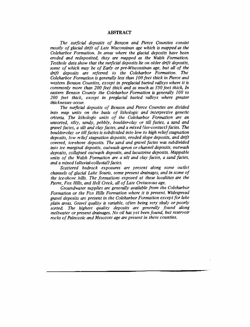
ABSTRACT
The surficial deposits of Benson and Pierce Counties consis tmostly of glacial drift of Late Wisconsinan age which is mapped as th eColeharbor Formation . In areas where the glacial deposits have bee neroded and redeposited, they are mapped as the Walsh Formation .Testhole data show that the surficial deposits lie on older drift deposits,some of which may be of Early or pre-Wisconsinan age, but all of th edrift deposits are referred to the Coleharbor Formation . TheColeharbor Formation is generally less than 100 feet thick in Pierce andwestern Benson Counties, except in preglacial buried valleys where it i scommonly more than 200 feet thick and as much as 350 feet thick. Ineastern Benson County the Coleharbor Formation is generally 100 to200 feet thick, except in preglacial buried valleys where greate rthicknesses occur.
The surficial deposits of Benson and Pierce Counties are divide dinto map units on the basis of lithologic and interpretive geneticcriteria. The lithologic units of the Coleharbor Formation are anunsorted, silty, sandy, pebbly, boulder-clay or till facies, a sand an dgravel facies, a silt and clay facies, and a mixed (ice-contact) facies . Theboulder-clay or till facies is subdivided into low to high relief stagnatio ndeposits, low relief stagnation deposits, eroded slope deposits, and driftcovered, ice-shove deposits . The sand and gravel facies was subdividedinto ice marginal deposits, outwash apron or channel deposits, outwas hdeposits, collapsed outwash deposits, and lacustrine deposits . Mappableunits of the Walsh Formation are a silt and clay facies, a sand facies ,and a mixed (alluvial-colluvial) facies .
Scattered bedrock exposures are present along some outle tchannels of glacial Lake Souris, some present drainages, and in some ofthe ice-shove hills. The formations exposed at these localities are th ePierre, Fox Hills, and Hell Creek, all of Late Cretaceous age .
Groundwater supplies are generally available from the ColeharborFormation or the Fox Hills Formation where it is present. Widespreadgravel deposits are present in the Coleharbor Formation except for lak eplain areas . Gravel quality is variable, often being very shaly or poorlysorted. The highest quality deposits are generally found alon gmeltwater or present drainages . No oil has yet been found, but reservoirrocks of Paleozoic and Mesozoic age are present in these counties.
2
INTRODUCTIO N
Purpose of Study
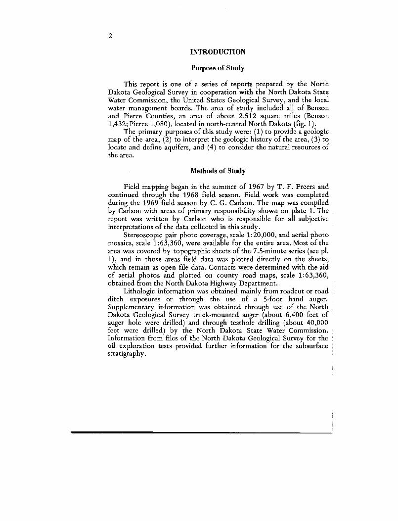
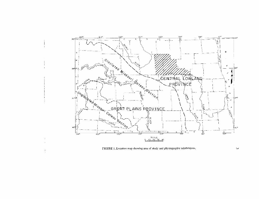
This report is one of a series of reports prepared by the Nort hDakota Geological Survey in cooperation with the North Dakota StateWater Commission, the United States Geological Survey, and the localwater management boards . The area of study included all of Bensonand Pierce Counties, an area of about 2,512 square miles (Benso n1,432 ; Pierce 1,080), located in north-central North Dakota (fig . 1) .
The primary purposes of this study were : (1) to provide a geologicmap of the area, (2) to interpret the geologic history of the area, (3) t olocate and define aquifers, and (4) to consider the natural resources o fthe area.
Methods of Study
Field mapping began in the summer of 1967 by T . F . Freers andcontinued through the 1968 field season . Field work was complete dduring the 1969 field season by C . G. Carlson . The map was compile dby Carlson with areas of primary responsibility shown on plate 1 . Thereport was written by Carlson who is responsible for all subjectiv einterpretations of the data collected in this study.
Stereoscopic pair photo coverage, scale 1 :20,000, and aerial photomosaics, scale 1 :63,360, were available for the entire area . Most of th earea was covered by topographic sheets of the 7 .5-minute series (see pl .1), and in those areas field data was plotted directly on the sheets ,which remain as open file data . Contacts were determined with the ai dof aerial photos and plotted on county road maps, scale 1 :63,360 ,obtained from the North Dakota Highway Department .
Lithologic information was obtained mainly from roadcut or roa dditch exposures or through the use of a 5-foot hand auger .Supplementary information was obtained through use of the Nort hDakota Geological Survey truck-mounted auger (about 6,400 feet o fauger hole were drilled) and through testhole drilling (about 40,000feet were drilled) by the North Dakota State Water Commission .Information from files of the North Dakota Geological Survey for th eoil exploration tests provided further information for the subsurfac estratigraphy .
SCAL E0 10 20 30 40
FIGURE 1 . Location map showing area of study and physiographic subdivisions .
98°
97°
49 °
248 °
LOVVL 4
PROVI !C E1
i
!
N .
coo/,.i
L
o .
iO
GR~ t--._PLAINS P OV I IJC E
ofEOAR'—i
,s
<
~- -`~,
r-cREEK e
cr •m
00°
99°
47°
4
Previous Work
Regional studies by Upham (1896), Simpson (1912, 1929), andLeverett (1932) made some mention of the area of study . More recen tregional studies relating more specifically to this area were made b yLemke and Colton (1958), Lemke (1958), Lemke, and others (1965) ,and Clayton (1966) . Detailed studies of the geology of local area swithin the two counties include those of the Flora quadrangle (Branch ,1947), the Oberon quadrangle (Tetrick, 1949), and the Tokioquadrangle (Easker, 1949) . Groundwater studies were conducted in theMinnewaukan area (Aronow, Dennis, and Akin, 1953) and the Leedsarea (Randich and Bradley, 1962) . The glacial and post-glacial historyof the Devils Lake areas has been discussed by Aronow (1957) andHansen (1958) . A guidebook for the Devils Lake area (Laird., 1957 )includes the southeastern part of Benson County . A generalized map ofthis area on a scale of 1 :500,000 is provided by Colton, Lemke, andLindvall's (1963) Preliminary Glacial Map of North Dakota .
Geologic studies for the current groundwater series for adjacen tcounties have been published for Eddy County (Bluemle, 1965), Well sCounty (Bluemle and others, 1967), Rolette County (Deal, 1972), andNelson County (Bluemle, 1973) . Field studies have been conducted an dgeologic maps were available for Sheridan and McHenry Counties .
Acknowledgments
The help of various individuals and agencies in the collection ofdata for this study and their review of the manuscript is appreciated .Philip G . Randich, U.S. Geological Survey, author of parts II and III o fthis study, assisted by Charles E. Naplin, North Dakota State WaterCommission, provided testhole data which aided the geologicinterpretations of this report . Visitations in the field with geologists ofthe cooperating agencies also aided in the interpretations .
Regional Setting
Physiographically, the Benson and Pierce County area is in theWestern Young Drift Section of the Central Lowland Province (fig. 1) ,an area characterized by numerous undrained depressions, poorl yintegrated drainage, and a variable thickness of glacial drift . Most of thearea is in the Drift Plains District . Exceptions are parts of westernPierce County, which is in the Souris Lake Plain District, and th eeastern part of Benson County, which is in the Devils Lake Plai nDistrict .
5
The surficial deposits consist of Pleistocene sediments of Lat eWisconsinan age laid down on deposits of earlier glaciations or rock o fCretaceous age. The slope of the bedrock topography is toward thenorth and east . The dip of the sedimentary rocks is toward the west ,reflecting the position of this area on the eastern flank of the Willisto nbasin, an intracratonic basin, the center of which is in western NorthDakota .
PRE-QUATERNARY STRATIGRAPH Y
Precambrian Rocks
Only four wells have penetrated Precambrian rocks in Benson andPierce Counties, but wells in adjacent counties provide additiona linformation and a means of projecting the probable composition an ddepth to the Precambrian rocks of these counties. Based on thisinformation Lidiak and Karner (in preparation) have recognized thre eseparate terranes in this area, the Towner Granite Terrane, the Ramse yGranite Terrane, and an Amphibolite Schist Terrane . Depth to thePrecambrian rocks ranges from about 3,000 feet in southeastern Benso nCounty to about 6,000 feet in western Pierce County .
Paleozoic Rock s
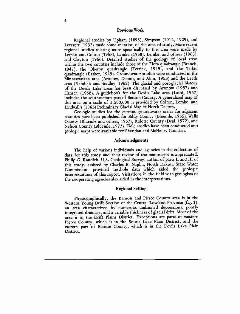
Paleozoic rocks range in thickness from about 3,200 feet inwestern Pierce County to about 2,300 feet in northeastern PierceCounty and about 1,200 feet in southeastern Benson County . Much ofthe variation in thickness is due to episodes of erosion marked byunconformities on the cross section (fig . 2) . For purposes of discussion ,it is convenient to divide the stratigraphic section into sequences, asequence being the preserved sedimentary record bounded by majorregional unconformities . Paleozoic sequences recognized in this are aare, in ascending order, the Sauk, Tippecanoe, and Kaskaskia .
Sauk SequenceAll the rocks of the Sauk Sequence are included in the Deadwoo d
Formation which consists of interbedded clastics and carbonates . Basedon testholes in adjacent areas about 200 feet of Deadwood is probablypresent in southwestern Pierce County . It thins northeastward to anerosional edge in the adjacent counties .

6
A
392 0
A .J . Hodges - Mart'ln No .
SE . SE . 23-152-7 4
1596 ' 6.L .
6 32
CJIY2rt - Srodium No . 1
NW, SE . 3I954-T 0
1637 k 9
A'
706
435
Shell - Morchus No I
Mldwedt - Heckman No . I
SE SE . 23-157-70
SW . NE 12-158-6 9
!641 ' S L
1589 ' D .F.
FIGURE 2 . Geologic section of subsurface stratigraphy of Benson and Pierce Counties .
7
Tippecanoe Sequenc eRocks of the Tippecanoe Sequence range in thickness from abou t
1,100 feet to 1,250 feet . The relatively uniform thickness reflects stableconditions during deposition of these rocks and a location where thedepositional thicknesses of all the formations, with the exception of theInterlake Formation, have been preserved . The Tippecanoe Sequenc ebegan with clastics of the Winnipeg Group followed by carbonates an dminor evaporites of the Red River, Stony Mountain, Stonewall, an dInterlake Formations. The Interlake Formation thins from about 250feet in western Pierce County to an erosional edge in southeaster nBenson County .
Kaskaskia SequenceRocks of the Kaskaskia Sequence range in thickness from abou t
100 feet in southeastern Benson County to about 1,800 feet in westernPierce County. The Devonian rocks are mostly carbonates with mino ramounts of evaporites and shales . They thin southeastward, primarilybecause of depositional thinning, but also as a result of mino runconformities between Mississippian and Devonian rocks as well a swithin the Devonian rocks . The Mississippian rocks are primaril ycarbonates with some anhydrite . They thin eastward from a thicknessof about 1,000 feet in southwestern Pierce County to an erosional edgein southeastern Benson County. The thinning is mainly a result o ferosion associated with the regional unconformity .
Mesozoic Rocks
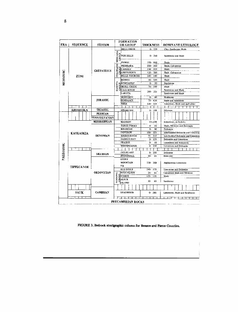
Mesozoic rocks are mostly fine-grained clastics that range i nthickness from about 1,500 feet in southeastern Benson County t oabout 2,900 feet in western Pierce County . These rocks are divided int otwo sequences in this area, the Absaroka and Zuni (figs . 2, 3) .
Absaroka SequenceThe Spearfish Formation of Triassic age is the only remnant of the
Absaroka Sequence in the two counties . It consists of redbeds thatrange in thickness from about 60 feet in northwestern Pierce County t oan erosional edge, which nearly coincides with the Pierce-Bensonboundary .
Zuni SequenceThe Zuni Sequence includes the rocks of Jurassic and Cretaceou s
age . The Jurassic rocks, which consist mainly of shale with some fine
8
ERA SEQUENCE SYSTEMFORMATION
OR GROUP THICKNESS DOMINANT LITHOLOGYHELL CREEK 0-
150 Clay, Sandstone, Shale
Z
X c FOX HILLS 0- 350 Sandstone and Shale
C L)PIERRE 150-
860 Shal eNIOBRARA 220-
260 Shale, Calcareous
CRETACEOUSE aO CARLILE 330-
325 Shal eU OU GREENHORN 120-
200 Shale, Calcareou s
N ZUNIOV BELLE FOURCHE 140-
180 Shal e
MOWRY 80-
100 ShaleE. ]NEWCASTLE 0-
50 Sandston e
c SKULL CREEK 70-
100 Shalep U FALL RIVER Sandstone and Shale
200-
32 5LAKOTA Sandstone and Shale
MORRISON 0-
60 MudstoneJURASSIC SUNDANCE 75-
430 Shale and SandstonePIPER 120-
225 Limestone, Shale and Anhydrit e1
1
I
I
I 1
1
I
i
l
l
l
l
f
l
l
l 11
I
I
I
I
I
IABSAROKA TRIASSIC SPEARFISH
0-
100 Siltston e
PERMIA NPENNSYLVANIA N
MISSISSIPPIAN MADISON 0-1,100 Limestone, Anhydrite
THREE FORKS 0-
50 Shale, Siltstone and DolomiteBIRDBEAR 0-
80 Dolomite
KASKASKIA DUPEROW 100-
325 Interbedded Dolomite and Limesto nDEVONIAN SOURIS RIVER 75-
225 Interbedded Dolomite and Limesto nDAWSON BAY 0-
125 Dolomite and LimestonePRAIRIE 0-
50 Limestone and AnhydriteWINNIPEGOSIS 0-
150 Limestone and Dolomit e
N Ilfltl IIIIIIIillll IIIIIIIII ISILURIAN
INTERLAKE 0-
250 Dolomit e..7 STONEWALL 50-
65 Dolomit e
pd., STON YMOUNTAIN 130-
160 Argillaceous Limestone
TIPPECANOE FM .RED RIVER 540-
575 Limestone and DolomiteORDOVICIAN U ROUGHLOCK 25-
65 Calcareous shale and Siltstonet' ICEBOX 125-
135 ShaleZ C BLACK
10-
60 Sandstone3 ` ISLAN D
CAMBRIA NSAUK DEADWOOD 0- 200 Limestone, Shale and Sandstone
I
I
I
I
I
I I
I
1
1
I
I
I
I
I
I
I I
I
I
I
I
I__II
I
I
PRECAMBRIAN ROCKS
FIGURE 3 . Bedrock stratigraphic column for Benson and Pierce Counties .
9
grained sandstone, thin from about 600 feet in northwestern Pierc eCounty to about 100 feet in southeastern Benson County . The thinningreflects a minor unconformity between the Jurassic and CretaceousSystems. The unconformity is overlain by sand and minor shale of theLower Cretaceous Lakota-Fall River Interval. These sediments areoverlain by marine shale of the Skull Creek through Pierre Formations .The Fall River-Lakota Interval, an aquifer that contains saline water, i sgenerally 200 to 300 feet thick and is penetrated at depths of abou t1,400 to 2,200 feet from east to west.
Cretaceous rocks range in thickness from about 1,200 feet ineastern Benson County to about 2,250 feet in western Pierce County .Most of the thinning is due to preglacial erosion of the Cretaceou sformations, which subcrop beneath the drift .
The Pierre Formation crops out along the Sheyenne valley an dsubcrops beneath the drift in eastern Benson County . The Fox Hill sFormation consists of thin-bedded shale and sand probably deposite dnear shorelines during the regressive phase of the Cretaceous seas . TheFox Hills Formation crops out along the Sheyenne drainage in westernBenson County and along the glacial Lake Souris outlet channels insouthern Pierce County . It subcrops beneath the drift in westernBenson County and most of Pierce County . Remnants of thenon-marine Hell Creek Formation are the youngest bedrock present inthe area. Exposures are limited to the ice-shove areas of southwester nPierce County .
QUATERNARY STRATIGRAPH Y
Coleharbor Formation
The Coleharbor Formation was defined by Bluemle (1971, p . 16)to include all of the glacial sediments in North Dakota . The typesection is located about 6 miles west of Coleharbor in McLean County .In that area evidence of multiple episodes of glaciation exists . The sameis true of the Benson-Pierce County area where testholes penetratedtill-sand-till successions with as many as 3 to 6 separate till section spresent at many localities . Although some recognizable differences canbe seen between some of the till sections they are not lithologicallydistinguishable as continuous units on the basis of sample descriptions .It is therefore convenient to include all the drift deposits in this are awithin the Coleharbor Formation .
10
The Coleharbor Formation is subdivided into map units on th ebasis of objective observations of near-surface lithologies that weredivided into lithofacies and then a subjective interpretation based o ngenetic considerations . Four lithofacies were recognized : a boulder-clayor till facies, a sand and gravel facies, a silt and clay facies, and a mixe dfacies . Topographic expression, differences recognizable on aeria lphotos, and relationships to adjacent facies (pl . 1) were used as thebasis of subjective interpretations of origin.
In the Souris Lake Plain District, the composition of theColeharbor Formation in testhole footage was 23 percent till, 3 1percent sand and gravel, and 46 percent silt and clay . In the rest of thetwo counties testholes penetrated 73 percent till, 20 percent sand an dgravel, and only 7 percent silt and clay, except in areas where testholedrilling was directed at delineating buried valleys . In those areas thesand and gravel facies accounted for 40 to 60 percent of the footage .
The thickness of the Coleharbor Formation is greatest in th eburied valleys of the preglacial or ice marginal drainages (pls . 2 and 3) .In these areas, thicknesses of 250 to 350 feet are common ; whereas inmost of Pierce County and southwestern Benson County the drift is les sthan 100 feet thick. An area about 2 to 3 townships wide (Twps. 153to 157 N., Rs. 67 to 69 W .) that extends through eastern BensonCounty is characterized by drift in the 100- to 200-foot-thick range.This area of thicker drift is characterized by testholes that penetratedmultiple till successions .
Boulder Clay or Till FaciesThe boulder-clay or till facies represents the unsorted glacial drift
which is generally composed of silty clay with variable amounts o fangular, subangular or rounded sand grains, pebbles, cobbles, an dboulders. In some areas, however, the unsorted drift is silty and sand yso the general term for unsorted drift, till facies, will be used in thi sreport . This facies is generally yellowish brown to moderate yellowishbrown in the oxidized zone, which ranges in depth from 10 to 25 feet ;it is generally an olive gray below the oxidized zone . Till samples fromthe subsurface are commonly olive gray, but some medium gray andmedium dark gray till has been reported . Some testholes also reportedbrownish gray till indicating preservation of buried oxidized zones .Where testholes penetrated multiple till successions the buried tills ar esimilar in composition to the near surface till . The buried till iscommonly described as pebbly, silty clay, but in some localities sand yor gravelly till was also reported. The most noticeable difference
1 1
between the near-surface and buried tills in areas of multiple tills is tha tthe buried tills are more compact, often as tough or tougher to auge rthan the bedrock .
The till facies is divided into 6 map units . Five of these units(Cb1,2,4,5,6) are based primarily on surface expression with its implie ddeposition or erosional history. The other unit (Cb3) was separate don the basis of higher sand content in the till in parts of its area . Localareas of water-sorted sediment (too small to show on a map of the scaleof plate 1) are present within these map units .
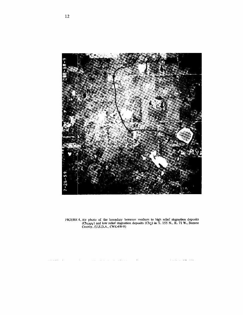
Ice Marginal and/or Low to High Relief StagnationDeposits.—Areas mapped as Cbl are areas of the till facies which wereeither deposited at the margin of an active ice sheet or wer etopographically high areas during the melting of the ice and it saccompanying deposition of debris . Most of these areas arecharacterized by low to medium or medium to high local relief .Generally low relief refers to areas with less than 30 feet of local relie fper section, medium relief refers to areas with 30 to 60 feet of relief pe rsection, and high relief refers to areas with greater than 60 feet of relie fper section . High relief areas (Cbl) grade into low relief areas (Cb2) soboundaries are somewhat arbitrary (fig . 4) . Areas mapped as Cb lgenerally lack the linear trends typical of end moraines, whereascircular disintegration ridges typical of stagnant ice deposits ar ecommon . The outer margin of the till facies mapped as Cbl hasoutwash channels and aprons leading away from these margins . Thechannel and apron deposits coincide with the present drainage . Someundrained depressions of one to three square miles and many smalle rones are present north and east of the area mapped as Cb1NV• Thissuggests that the margin of the active glacier which deposited thesurface drift of this area may have been some distance beyond the ma parea during the final stages of active ice movement and that, during th emelting stages, most of the areas mapped as Cbl were merelytopographically high areas of stagnant ice .
The area designated Cb1H is a continuation of the area mapped a sthe Heimdal End Moraine in Wells and Eddy Counties . In BensonCounty this area is characterized by low to medium relief stagnatio nfeatures. Local relief that is less than 30 feet in secs . 13 and 14, T . 152N., increases slightly southward but remains less than 60 feet in mos tareas. Two testholes were drilled to bedrock in this area; one(152-71-36ccc) penetrated 55 feet of drift, the other (151-70-18ccc) 4 0feet of drift .
The area designated Cb1MR is a continuation of the area mappe das the Martin End Moraine in Wells and Sheridan Counties . The
1 2
FIGURE 4 . Air photo of the boundary between medium to high relief stagnation deposits(Cb1NV) and low relief stagnation deposits (Cb2) in T. 155 N., R . 71 W., Benso nCounty . (U .S.D .A ., CWK-6W-9)
1 3
segments in Twps . 152 and 153 N . are similar in appearance on aerialphotos to the areas designated Cb1H; the low to medium reliefstagnation features are present and six testholes were drilled to bedroc kwith drift thicknesses ranging from 9 to 54 feet. In Twp. 151 N. thedrift is much thicker . Two testholes (151-73-16ddd, 151-73-32ccc )penetrated over 200 feet of drift, and one testhole (151-73-28ccc )penetrated 185 feet of drift ; however, these testholes are in an area of abedrock valley. The near-surface till was less than 40 feet thick in eac hof these testholes .
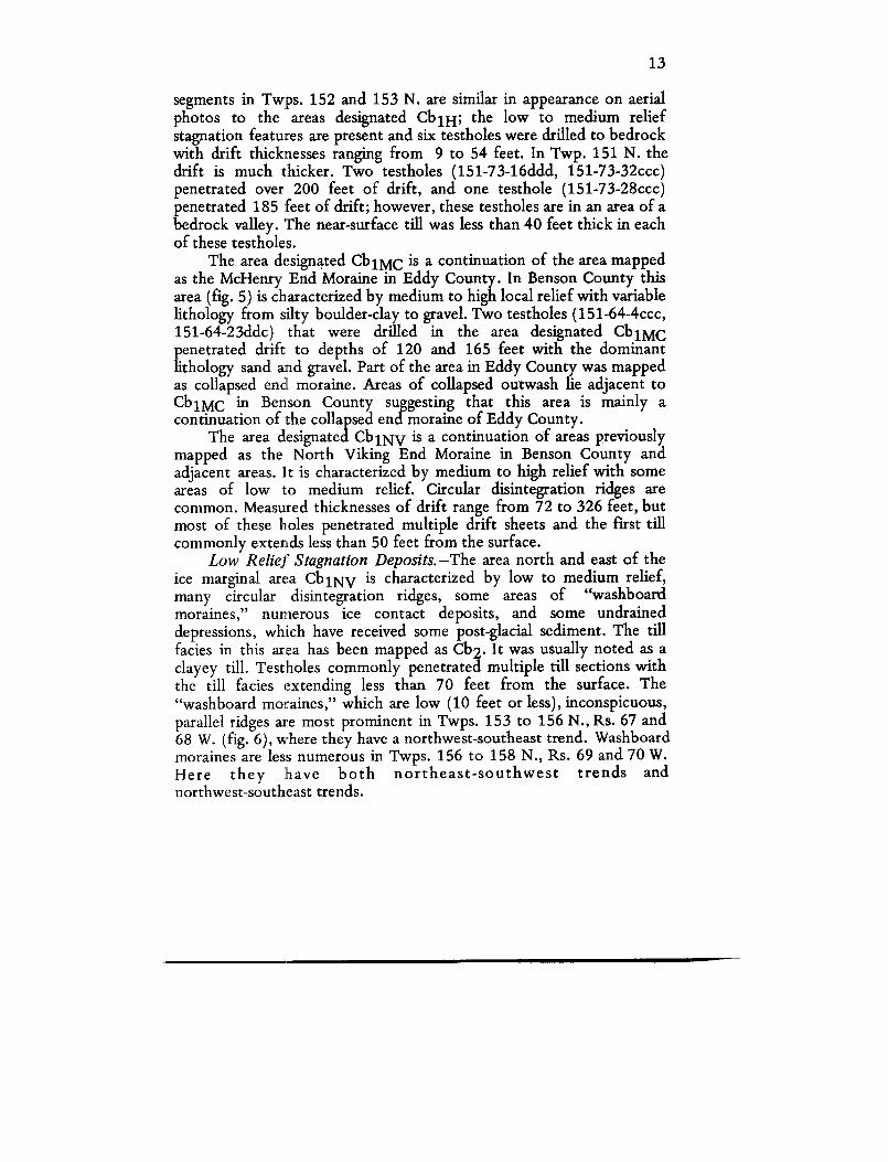
The area designated Cb1MC is a continuation of the area mappedas the McHenry End Moraine in Eddy County . In Benson County thisarea (fig. 5) is characterized by medium to high local relief with variabl elithology from silty boulder-clay to gravel . Two testholes (151-64-4ccc ,151-64-23ddc) that were drilled in the area designated Cb1MCpenetrated drift to depths of 120 and 165 feet with the dominan tlithology sand and gravel . Part of the area in Eddy County was mappe das collapsed end moraine . Areas of collapsed outwash lie adjacent t oCb1MC in Benson County suggesting that this area is mainly acontinuation of the collapsed end moraine of Eddy County .
The area designated Cb1NV is a continuation of areas previouslymapped as the North Viking End Moraine in Benson County an dadjacent areas. It is characterized by medium to high relief with som eareas of low to medium relief. Circular disintegration ridges ar ecommon . Measured thicknesses of drift range from 72 to 326 feet, bu tmost of these holes penetrated multiple drift sheets and the first til lcommonly extends less than 50 feet from the surface .
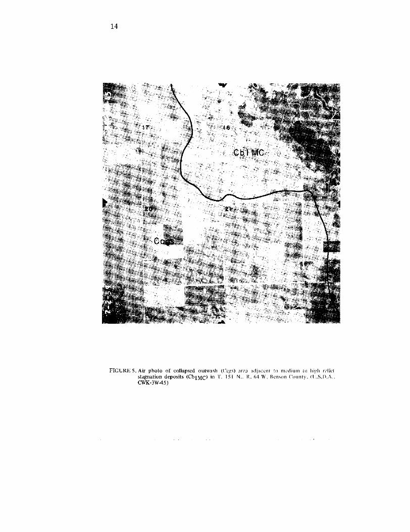
Low Relief Stagnation Deposits.—The area north and east of th eice marginal area Cb1NV is characterized by low to medium relief,many circular disintegration ridges, some areas of "washboardmoraines," numerous ice contact deposits, and some undraine ddepressions, which have received some post-glacial sediment. The tillfacies in this area has been mapped as Cb2 . It was usually noted as aclayey till . Testholes commonly penetrated multiple till sections wit hthe till facies extending less than 70 feet from the surface . The"washboard moraines," which are low (10 feet or less), inconspicuous ,parallel ridges are most prominent in Twps . 153 to 156 N., Rs. 67 and68 W. (fig. 6), where they have a northwest-southeast trend . Washboardmoraines are less numerous in Twps . 156 to 158 N ., Rs. 69 and 70 W .Here they have both northeast-southwest trends andnorthwest-southeast trends .
1 4
FIGURE 5 . Air photo of collapsed outwash (Ccgs) area adjacent to medium to high relie fstagnation deposits (CbIMC) in T . 151 N . . R . 64 W . Benson County . (U_S .I) .A . .CWK-3W-45)
1 5
I IGURI 6 Air photo of "washboard moraines" in low relief stagnation deposits (Cb2) in T .155 N . IL 67 W ., Benson County . (U .S .D .A . . CWK-4W-155)
16
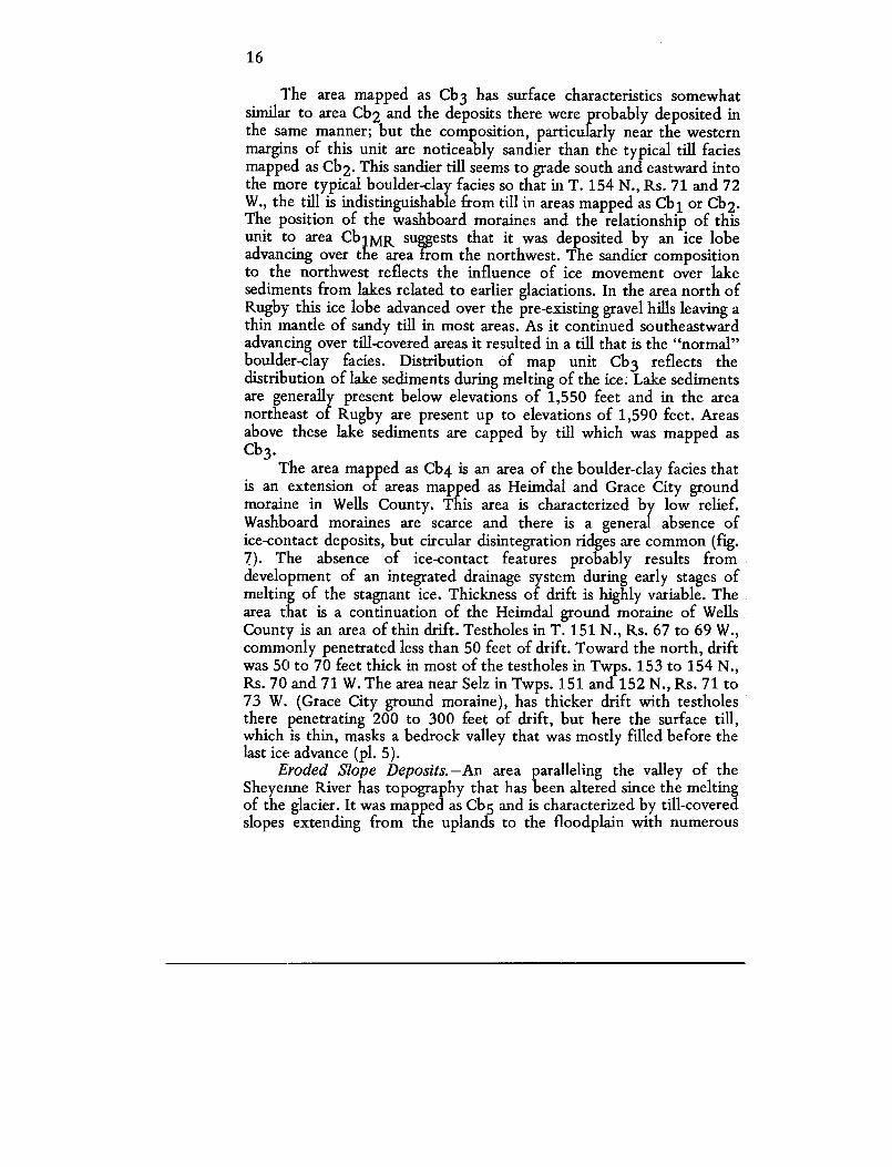
The area mapped as Cb3 has surface characteristics somewha tsimilar to area Cb2 and the deposits there were probably deposited inthe same manner; but the composition, particularly near the wester nmargins of this unit are noticeably sandier than the typical till facie smapped as Cb2 . This sandier till seems to grade south and eastward int othe more typical boulder-clay facies so that in T . 154 N., Rs . 71 and 7 2W., the till is indistinguishable from till in areas mapped as Cb 1 or Cb2 .The position of the washboard moraines and the relationship of thi sunit to area Cb1MR suggests that it was deposited by an ice lob eadvancing over the area from the northwest . The sandier compositio nto the northwest reflects the influence of ice movement over lak esediments from lakes related to earlier glaciations . In the area north o fRugby this ice lobe advanced over the pre-existing gravel hills leaving athin mantle of sandy till in most areas . As it continued southeastwar dadvancing over till-covered areas it resulted in a till that is the "normal "boulder-clay facies . Distribution of map unit Cb3 reflects th edistribution of lake sediments during melting of the ice ; Lake sedimentsare generally present below elevations of 1,550 feet and in the are anortheast of Rugby are present up to elevations of 1,590 feet . Areasabove these lake sediments are capped by till which was mapped a sCb3 .
The area mapped as Cb4 is an area of the boulder-clay facies tha tis an extension of areas mapped as Heimdal and Grace City groun dmoraine in Wells County . This area is characterized by low relief.Washboard moraines are scarce and there is a general absence ofice-contact deposits, but circular disintegration ridges are common (fig .7). The absence of ice-contact features probably results fro mdevelopment of an integrated drainage system during early stages o fmelting of the stagnant ice . Thickness of drift is highly variable . Thearea that is a continuation of the Heimdal ground moraine of WellsCounty is an area of thin drift . Testholes in T. 151 N., Rs. 67 to 69 W. ,commonly penetrated less than 50 feet of drift . Toward the north, drif twas 50 to 70 feet thick in most of the testholes in Twps . 153 to 154 N . ,Rs . 70 and 71 W. The area near Selz in Twps . 151 and 152 N., Rs. 71 to73 W. (Grace City ground moraine), has thicker drift with testhole sthere penetrating 200 to 300 feet of drift, but here the surface till ,which is thin, masks a bedrock valley that was mostly filled before thelast ice advance (pl . 5) .
Eroded Slope Deposits.—An area paralleling the valley of th eSheyenne River has topography that has been altered since the meltin gof the glacier . It was mapped as Cb5 and is characterized by till-covere dslopes extending from the uplands to the floodplain with numerous
1 7
FIGURE 7 . Air photo of low relief stagnation deposits overlying buried preglacial channe ldeposits T . 151 N., R . 71 W., Pierce County . (U .S .D .A ., CWK-3W-3)

18
bedrock exposures, particularly in roadcuts . Scattered patches o fwater-sorted deposits (kame terrace, Cgs) occur at various elevation salong the valley walls, the larger of which were separated and are show non plate 1 as sand and gravel facies . Some smaller patches are als opresent .
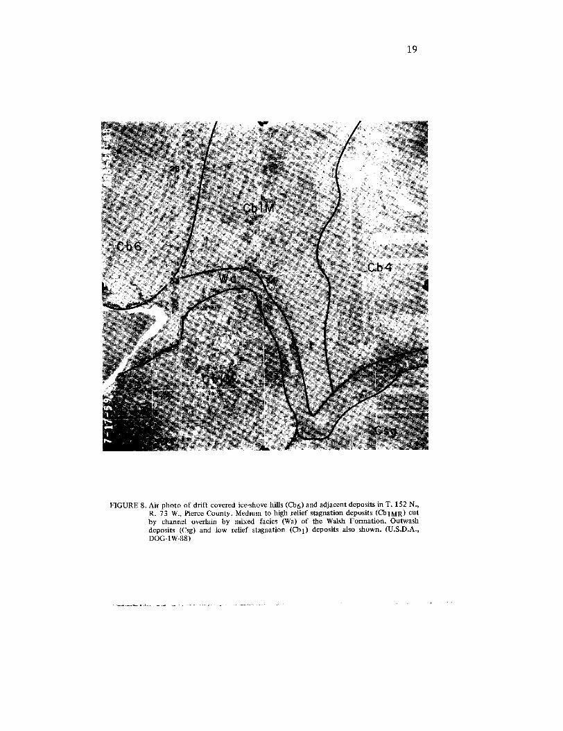
Drift Covered Ice-Shove Features.—Several of the drift-covered(Cb6) hills in southwestern Pierce County have exposures of disturbedbedrock on their western flanks . The pattern of the ridges on aeria lphotos (fig. 8) indicate that these hills were probably formed by ic eshove and shearing by an ice lobe advancing southeastward (Bluemle ,1970, p. 325), which then overrode the hills .
A hill in Twps. 154 and 155 N., R. 69 W., in Benson County has asimilar appearance except that no bedrock exposures are present . It isin an area of relatively thick drift near the Pierre-Fox Hills contact an da bedrock escarpment (pl . 2) that may have caused shearing similar t othat of southwestern Pierce County. This may have happened as the lastice advanced over this area or it may be an ice-shove feature of a nearlier glaciation that was not appreciably changed by the last ice sheet .
Sand and Gravel Fade sThe water-sorted deposits of the Coleharbor Formation wer e
divided on the basis of grain size into two facies with the coarse rfraction mapped as the sand and gravel facies . This facies, which is thesecond most extensive of the surface units, was divided into five ma punits on the basis of grain size, sorting, and mode of deposition . Mapunits recognized were gravel and gravelly sand, outwash apron o rchannel deposits, collapsed outwash, outwash, and lacustrine sand .
Gravel and Gravelly Sand.—Areas mapped as Cgs are areas in whic hthe coarser fraction of the sand and gravel facies is well sorted . Thesedeposits are of several types . One type is located along the valley wall sof present drainages that also carried away much of the meltwater a sthe last ice sheet melted. They are probably kame terrace deposits .Another type of deposit is closely associated with the ice-marginal(Cbl) deposits. Some of these are gradational into an adjoining gravellysand facies and represent deposition of the coarsest sediment nearest t othe source of supply . In Twps. 157 and 158 N., R. 71 W., these gravellydeposits may have been deposited by meltwater flowing into the early ,high level stages of glacial Lake Souris .
Most of the high hills north of Rugby in Rs . 72 and 73 W. seem tobe cored mostly by gravel and gravelly sand. Where these hills have acap of till, they were mapped as Cb4; where the cap of till was missing ,they were mapped as Cgs. Good exposures generally reveal a great
1 9
FIGURE 8 . Air photo of drift covered ice-shove hills (Cb6) and adjacent deposits in T . 152 N . ,R. 73 W ., Pierce County . Medium to high relief stagnation deposits (Cb1MR) cutby channel overlain by mixed facies (Wa) of the Walsh Formation . Outwashdeposits (Csg) and low relief stagnation (al) deposits also shown . (U .S .D .A . ,DOG-1 W-88)
20
variety of grain size and bedding characteristics, but nearly always th esediment is poorly sorted, almost as if the sediment were dumped sorapidly that the sorting one might expect in waterlain deposits is no tpresent . The layers of gravelly sand are mainly horizontally bedded, butsome cross bedding is present . Inclusions of unsorted gravelly till ar esometimes present. These hills are probably kame deposits that wer eoverridden by the last glacial advance .
Outwash Apron or Channel Deposits.—Outwash apron or channeldeposits (Csg) are present near the ice marginal (Cbl) till deposits an dare closely related genetically . These low relief deposits of gravel ,gravelly sand, and sandy gravel are present as outwash apron scontinuing as channel deposits leading to valleys of the present-daydrainage where they may be present below younger deposits of th eWalsh Formation.
Collapsed Outwash .—An area in Twps . 151 and 152 N., Rs. 62 to66 W., consists of predominantly sand and gravel deposits in an area o fmedium to high (50 to 100 feet) local relief with local patches of th eboulder clay facies (fig. 5) . Testholes in this area generally penetrate dmultiple tills . The surface relief indicates that these water-sorte ddeposits were laid down on buried ice and that the relief is due tosubsequent collapse as the buried ice melted .
Outwash.—Areas of low relief topography developed on sandassociated with ice marginal deposits of Cb1MR and Cb1H weremapped as Cos . These areas are similar to the outwash apron deposit s(Cgs) except that they are generally finer grained and better sorted .
Lacustrine Sand.—Widespread areas of nearly flat, fine- t overy-fine-grained sand (Cls) occur in Twps. 151 to 158 N ., R. 75 W., inthe Souris Lake Plain District, at elevations below 1550 feet . Similarlacustrine sand occurs at higher elevations (1550 to 1580) in Twps. 156and 157 N ., Rs . 71 and 72 W. These high-level sand deposits weredeposited during early stages of glacial Lake Souris .
Silt and Clay FadesFine-grained lacustrine deposits of the silt and clay facies (Csc) o f
the Coleharbor Formation are present at the surface in two areas . Themost extensive are the yellow-gray to light-yellow-brown, thin-bedde ddeposits in the Souris Lake Plain . Less extensive deposits are present inthe Minnewaukan area and extending eastward in Twps. 152 and 153N. in the Devils Lake basin .
21
Mixed FaciesThere are numerous areas within the general area of low relief
stagnation deposits (Cb 2 and Cb4) where there are low hills or ridge swhich are composed of variable lithologies deposited as ice contac tdeposits (Cic) . The twisting, linear ridges are eskers which generally ar ecomposed of gravel and gravelly sand . The smaller, knob-like forms ar ekames which may contain well sorted sand and gravel deposits, bu twhich often also contain silt and clay deposits or unsorted drift . A fewof the mixed-facies ice-contact deposits are also present in areas ofice-marginal (Cb 1 ) and collapsed outwash deposits (Cgs) .
HOLOCENE STRATIGRAPH Y
Walsh Formation
The Walsh Formation was proposed by Bluemle (1973, p . 33) forthe rock-stratigraphic unit that overlies the Coleharbor and all otherformations in North Dakota . In Benson and Pierce Counties three type sof deposits that resulted from erosion and redeposition of glacial driftare mapped as Walsh Formation . These are a silt and clay facies (sloug hdeposits), a sand facies (sand dunes), and a mixed sand, silt, and cla yfacies (alluvium-colluvium) .
Silt and Clay FaciesMappable deposits of this facies (Wc) are confined to sloughs that
are present in the low relief stagnation areas. Most of the undraineddepressions (sloughs) associated with the circular disintegration ridg estagnation features of the ice marginal and/or low to high reliefstagnation areas probably contain thin deposits of this facies, but the yare of local extent and they were not separated as map units.
Sand FaciesLacustrine sand (Ws) deposits of the Coleharbor Formation hav e
been modified into low dunes in several areas of the Souris Lake Plai nDistrict (Twps . 73 and 74 W .) .' Another area of dunes is present in T .151 N., Rs . 62 and 63 W., where the Warwick outwash apron has bee nwind-modified into dune topography .
Mixed Sand-Silt-Clay FaciesAlluvium-colluvium (Wa) consisting of variable amounts of silt ,
sand, and clay is present on the floodplain of the Sheyenne River and
22
some of its tributaries . This facies is also recognizable alongintermittent drainages in eastern and southeastern Benson County, aswell as along the outlet channels of glacial Lake Souris.
GEOLOGIC HISTOR Y
Pre-Pleistocene
The pre-Pleistocene history of this area is based on the preservedsedimentary section discussed previously under pre-Quaternarystratigraphy . The history is one of alternating episodes of submergencewith marine deposition followed by episodes of emergence wit hremoval of part of the sedimentary record . Comparisons of th epreserved section in the Benson-Pierce County area with areas to th ewest show that this area, being nearer the margin of the Williston basin ,has been subject to longer intervals of erosion resulting in less of th esedimentary record being preserved . This erosional thinning isparticularly significant through the Paleozoic Era . In the Mesozoi cErathem the erosional thinning is minimal until the end of theCretaceous, and then the thinning of the Hell Creek, Fox Hills, an dPierre Formations is due primarily to erosion during the Tertiar yperiod .
The pre-Pleistocene topography was dominated by a drainagedivide in western Benson County with an escarpment held up by theFox Hills Formation paralleling the Pierre-Fox Hills Contact (pl . 2) .The drainage and general slopes trended toward the northeast . Earlyglaciations diverted drainage southeastward . New channels were cut b yboth the diverted drainage and meltwater from the glaciers . Thebedrock topography (pl. 2) is therefore a composite of the pre-glacialtopography and modifications resulting from glaciation .
No major valleys of the pre-Pleistocene drainage were present i nmost areas of these two counties, but a short segment of a major valle ywith a north-northwest trend in Towner and Ramsey Counties waspresent in the southeastern corner of Benson County . That stream mayhave been the northeastward course of the preglacial Knife-Cannonballdrainage . A shallow, northeast trending valley in northwestern Pierc eCounty was a tributary of that stream . Some tributaries of that streamare also present in eastern Benson County .
A deep northwest-southeast trending valley in southwestern Pierc eCounty may have been the course of the preglacial Knife River or hav ebeen a tributary of the Knife River drainage . On the basis of its course
23
and the composition of the valley fill which includes thick sand an dgravel deposits it was probably also a diversion channel for meltwate rfrom an early glaciation .
Pleistocene
Pre-Wisconsinan and early Wisconsinan ice sheets passed over thi sarea to reach areas in western North Dakota where deposits of thes eearly ice sheets are exposed . Many testholes penetrated multiplesections of till (pl. 4), and it seems likely that pre-Wisconsinan and earl yWisconsinan glaciers left deposits of drift in Benson and Pierce Countie sand that some of these drift deposits have been preserved . The lack o frecognizable physical differences to correlate sections of till betwee ntestholes, and the lack of ways of dating these deposits, make attempt sto construct an accurate history of deposition of the buried driftdeposits difficult at the present time . Detailed till analysis may provid ethe answers ; but perhaps the best approach for the present is to look a tthe most recent Pleistocene deposits, interpret their depositionalhistory, and then infer some general interpretations for the buried drift .
Surface features suggest that the unsorted drift of the last ice shee twas deposited when stagnant ice melted . Topographically high areas o nthe present land surface are generally highs on the bedrock surface (pl .4) that were already topographic highs when the first ice advanced ove rthe area . In some areas, such as southwestern Pierce County, highs o nthe bedrock surface are the result of the glaciers' shoving of blocks o fbedrock. In most areas the present topography is the result o fsuccessive glaciers moving over the pre-existing topography with littlemodification of the pre-existing surface. Sully's Hill is an exception ,which may be explained as an ice-shoved drift feature . When the last ic esheet began to melt, the thinnest ice, and hence the first ice-free areas ,were probably the areas that were topographically high before th eadvance of the last ice sheet . These areas were therefore againestablished as drainage divides .
Glacial Lake Souris formed to the north and west of a divid e(areas Cb1MR and Cb1NV on pl . 1) during an early stage of melting a televations up to about 1,590 to 1,600 feet . The lake probably didn'tremain at this level very long as at these levels numerous outlets to thesoutheast were available . From south to north, these outlets were PagelLake, Antelope Lake, Lesmeister Lake, Girard Lake-Buffalo Coulee ,Long Lake, and possibly the Cranberry Lake-North Fillmore outlets .These outlets have surface elevations of 1,530 to 1,550 feet except for
24
the Girard Lake spillway, which has surface elevations as low as 1,47 0feet . With the exception of the Girard Lake spillway, these outlets wer enot used for more than short periods of time, though, or they woul dhave been cut wider and deeper than they are .
A combination of the evidence of surface elevations of the outlet sof glacial Lake Souris and elevations of the surface deposits within th elake plain suggests that the lake dropped to the 1,550-foot leve lrelatively quickly . In Twps. 156 to 158 N ., Rs. 71 to 72 W., there arenumerous hills and depressions . Most of the hills are cored by sand an dgravel and capped by sandy till with the till present at elevations above1,550 feet. The hills are deposits of earlier glaciations which wer epresent as islands during early stages of glacial Lake Souris . Thedepressions result from melting of blocks of stagnant ice that wereinsulated during early stages of lake sedimentation . Fine- tovery-fine-grained sand is present in low relief areas at elevations o f1,550 to 1,590 feet except along the eastern margin where sand andgravel deposits flank the area mapped as Cb 1N V
In Twps. 151 to 154 N., Rs. 73 to 74 W., a similar pattern ispresent . At elevations of less than 1,550 feet, lacustrine sediments arepresent ; above 1,550 feet sandy till is the surface sediment on most o fthe hills . Some of the hills are definitely sand and gravel-cored whil eothers may be . The hills are deposits of early ice sheets which wereislands during early stages of lake sedimentation . In areas of low relief,fine-grained sand covers the surface up to elevations of 1,590 to 1,60 0feet. Numerous sloughs that occur at elevations ranging from abou t1,510 to 1,560 feet indicate stagnant ice during early stages of lakesedimentation in this area also . The lack of gravel deposits near the areamapped as Cb1MR is probably due to the number of channels cuttin gthrough this topographically high area . They resulted in the coarsematerial being deposited as outwash or kame terraces by meltwate rflowing through or along the margins of the outlet channels .
Shorelines at elevations below 1,550 feet are indistinct, du epartially to lowering lake levels before the buildup of beach depositsand partially to post-glacial changes . The Girard Lake spillway, withsurface elevations as low as 1,470 feet, provided a southeast outlet to a tleast that level . No testholes were located in the channel southeast o fGirard Lake so its depth is unknown . Testholes to the northwestsuggest a northwestward sloping bedrock valley .
The area mapped as Cb1NV marks the south and west drainagedivide of the Devils Lake basin . The high area north from T . 155 N .marks the divide between the Souris River drainage and the Devils Lak edrainage. During the melting of the stagnant ice in this area meltwater
25
flowing westward from the divide was ponded in glacial Lake Souris .Meltwater flowing eastward was ponded in glacial Lake Cando an dglacial Devils Lake . Washboard moraines indicate that ice moved ove rthe divide from the northwest to meet the ice advancing from th enortheast in T. 156 to 158 N., R. 69 W. The junction of thesedirections of flow is not marked by a large accumulation of drift butmany ice-contact deposits are found in this area and some meltwate rchannel deposits are found in the Ibsen Lake area . The abundance ofice-contact deposits probably resulted from the poorly integrateddrainage that existed while the ice was melting .
The area south .from T . 155 N. marks the divide between theSheyenne River and the Devils Lake basin. A narrow band of outwashdeposits occurs along the southern margin of the topographically higharea with channels leading to the Sheyenne River. The general lack ofice-contact deposits in this dead-ice moraine area probably reflects th eearly development of this integrated drainage system . That the channels(e .g ., Trappers Coulee, Big Coulee) were cut by meltwater is clearl yshown on cross sections (pl. 4, C-C') . Breaks in the topographically higharea (Cb1NV) provided routes of flow for meltwater from east of thedivide in the Sheep Lake and Fish Lake areas (T. 154 N., R. 69 W.) atelevations of 1,570 to 1,600 feet . However, most of the meltwaterprobably flowed eastward into the Devils Lake basin .
The level of Devils Lake has fluctuated through recorded histor yand probably ever since the ice melted . Lake deposits of silt, clay, andvery-fine-grained sand are present up to elevations of 1,450 feet inBenson County indicating that this was the highest stage of the lake .When it was at this level further inflow could escape through the Ston yLake-Long Lake channel and the Twin Lake channel to the Sheyennedrainage . Some water may also have drained through the Stump Lakearea to the Sheyenne River in Nelson County .
East and south of the Twin Lake outlet the surface till an doutwash were deposited on buried stagnant ice . The surficial and buriedoutwash are typically poorly sorted sand and gravel characterized by ahigh percentage of shale pebbles. Distribution of this outwash indicatesthat it must have been deposited prior to or during the early stages ofcutting of the Sheyenne valley .
The Sheyenne valley served as an outlet for much of the meltwate rof the last glaciation . The till-covered valley walls indicate that it hadalso served as a meltwater outlet for previous glaciations . The NorthFork of the Sheyenne River flows in a narrow valley from itsheadwaters to the junction with the Girard Lake spillway just southeas tof Buffalo Lake . The valley then widens to about 54 to lh mile in width
26
and is cut about 80 to 100 feet below the upland level . A short segmen tof the South Fork flows northward in a narrow valley to its junctio nwith the North Fork in T. 151 N., R. 71 W. At this junction th eSheyenne cuts through the Heimdal "End Moraine" and continueseastward between the North Viking and Heimdal "End Moraines . "Channels from those topographically high areas indicate that meltwaterfrom those areas was added to the Lake Souris overflow to cut th evalley of the Sheyenne . The course through the Heimdal "En dMoraine" in T . 151 N ., R. 71 W., may follow a topographic sagresulting from a valley cut into bedrock by a tributary of the dee pchannel in the Selz area . This segment was probably established durin gthe melting of an earlier glaciation and reoccupied by meltwater fro mthe latest glaciation .
The history of earlier advances of ice sheets over this area is bestpreserved in three areas . These are the Souris Lake Plain, the channel inthe Selz area, and the area north and east of the "North Viking EndMoraine." Generally the topographically high areas have relatively thi ndrift and may record an incomplete sedimentary record of the ic eadvances .
Testholes in the Souris Lake Plain commonly penetrated 2 or 3layers of till that were separated by lacustrine and/or outwash deposits .This indicates that during the melting of earlier ice sheets ponding o fmeltwaters occurred in the same general area as during the latestglaciation. Outlet channels probably drained to the southeast durin gearly stages of melting of earlier glaciers, too . The channel in the Selzarea was probably used by some of this meltwater . The Girard LakeSpillway may also have been used during early glaciations, but i tprobably then joined the channel in the Selz area to continue in theNew Rockford channel in Wells County . It seems likely that if theGirard Lake Spillway were used in early glaciations it was only durin gearly stages and the New Rockford or other channels were the mainsoutheast outlets of most of the earlier glaciations .
The surface deposits in the Selz area are till deposited by a Lat eWisconsinan ice sheet . The topography of the buried valley (pls . 2,5) isnot reflected at the surface, indicating that most of the fill (drift) inthis valley was already present when the last ice advanced over the area .Examination of the fill indicates a complicated history of cut and fill. Apossible sequence of events that would account for the sequence o fdeposits in the testholes is shown on the cross section (pl . 5, B-B') . Atleast four intervals of valley cutting, shown as a ., b ., c., and d. areindicated . The actual sequence of events may be more complicated .
27
Valley a . represents the preglacial profile; valleys b ., c., and d.represent cutting by diverted drainage, interglacial drainage, or outle tchannels of glacial lakes. Four or more different ice sheets advance dover the area depositing till units 1, 3, 5, and 7 . Units 2, 4, and 6 areprimarily water-sorted material deposited by glacial meltwaters an ddiverted or ponded drainage . Unit 2 is predominantly sand and gravelwith some interbedded silt and clay . The sand and gravel containsconspicuous amounts of lignite, scoria, and rocks of siliceouscomposition su{:esting a western source. These deposits are generallypoorly sorted su : esting an upper flow regime transport .
Testholes in eastern Benson County suggest that the bedrocktopography had a significant effect on drift thickness . The Pierre-Fo x
s contact was apparently nearly coincident with an escarpment . Eas tof this escarpment the drift is thicker than it is on or to the west of th eescarpment . Most testholes penetrate multiple sections of till separatedby water-sorted sediments (pl. 4, sections C-C', D-D') that probablyreflect a record of multiple glaciations . Some of the testholes whichpenetrated only unsorted drift have suggestions of multiple glaciationbased either on electric log characteristics or in some cases sampledescriptions. Examination of the cross sections su{:ests that in mostareas the drift deposits of the last ice advance do not exceed 50 feet inthickness. A comparison of the drift thickness (pl . 3) with the bedroc ktopography (pl . 2) shows that the thickest drift is present in area swhich were originally topographic lows ; the thinnest drift is in areaswhich were originally topographic highs, so the net effect of successiveglaciations has been to reduce local relief, but the original divides ar emostly reflected as divides of the present drainage .
Holocene
The glacial deposits have been slightly modified in some areas bythe forces of wind and water . Where these modifications resulted inrecognizable deposits they were mapped as the Walsh Formation .
The effect of wind has been of two types . One effect has been t oremove some of the fine-grained sediment from the area. This effect isquite noticeable in recent time because of cultivation practices, but itmay not have been significant under native vegetation conditions .Another effect has been to transport sand for short distances in areas o fsurface sand and redeposit it as low dunes .
In areas of interior drainage, slopewash from topographically highareas washes sediment into the low slough areas . Some thin silt and clay
28
deposits are probably present in all of the undrained depressions, bu tonly the larger areas were separated as map units .
Most of the present-day drainages were cut or deepened bymeltwater of the last glaciation. Alluvial deposits are now graduall yaccumulating in these valleys as a result of the decreased capacity of th epresent drainage .
A lake or a chain of lakes commonly occurs in outlet channels o fglacial Lake Souris and glacial Devils Lake . These lakes are shallow andprobably result from slopewash of the channel walls exceeding th ecapacity of the intermittent drainage that now occupies the channels .
ECONOMIC GEOLOGY
Groundwate r
Adequate supplies of water for domestic use are generally availablewithin the glacial drift in most areas of Benson and Pierce Counties . Ina few areas the drift is composed entirely of unsorted materials, and i nthese areas it may be necessary to seek supplies from the bedrockformations. The buried valleys are areas of high yield aquifers . Forinformation on specific areas one should consult part two of thisbulletin, which provides information from previous testholes, and partthree, which describes the aquifers in terms of areal extent, chemicalquality, and water-bearing characteristics . General availability ofgroundwater is provided by Hydrologic Atlas 476 (Randich, 1972) an dpart three of this bulletin .
Sand and Gravel
Gravel deposits of some kind are generally present within six mile sof any site in these counties with the exception of some areas withi nthe Souris Lake Plain . However, the quality of the gravel deposits variesso widely that each deposit must be investigated to determine it susefulness for a specific purpose . Troublesome points are related mainl yto poor sorting and high shale content .
In general, the better sorted deposits are those located along th evalleys of the present-day drainages . These are also less shaly . Theice-contact deposits are more variable, ranging from clean, well sorte dsand and gravel to poorly sorted or fine-grained material . The linearice-contact features (eskers) commonly provide the best prospects .Sand and gravel deposits in southeastern Benson County, particularly i nthe collapsed outwash area, are generally very shaly .
29
Petroleum
As of January 1, 1973, 44 oil exploration tests have been drilled inthe two-county area; 18 in Benson County, and 26 in Pierce County .No commercial finds have yet resulted, but only six of the tests havepenetrated Silurian rocks, and only 19 of the tests have penetrate dDevonian rocks . Considering the thickness of the preserved sedimentaryrocks and the position on the eastern flank of the Williston basin ,further testing may yet find oil in Benson and Pierce Counties .
30
SELECTED REFERENCES
Anderson, S . B., 1952, Summary of the Ajax Oil Company-Bell No . 1well : North Dakota Geol . Survey Circ . 10, 9 p .
Aronow, S ., 1957, On the post glacial history of the Devils Lake region ,North Dakota : Jour. Geology, v. 65, p . 410-427.
Aronow, S ., Dennis, P . E., and Akin, P . D., 1953, Geology and groun dwater resources of the Minnewaukan area, Benson County, Nort hDakota : North Dakota State Water Comm . County Ground WaterStudies 19, 125 p .
Babcock, E. J., 1902, Water resources of the Devils Lake region : NorthDakota Geol . Survey, 2nd Bien. Rpt., p . 208-250 .
Bluemle, J . P., 1965, Geology and ground water resources of Eddy an dFoster Counties, North Dakota, Part I-Geology : North DakotaGeol. Survey Bull . 44 and North Dakota State Water Comm .County Ground Water Studies 5, 66 p .
Bluemle, J. P., 1970, Anomalous hills and associated depressions i ncentral North Dakota: Geol. Soc. America (abs.), Program, 23r dannual meeting Rocky Mountain Section, p . 375 .
Bluemle, J . P ., 1971, Geology of McLean County, North Dakota : NorthDakota Geol. Survey Bull . 60, pt . I and North Dakota State WaterComm. County Ground Water Studies 19, pt . I, 65 p.
Bluemle, J . P., 1973, Geology of Nelson and Walsh Counties, NorthDakota: North Dakota Geol . Survey Bull . 57, pt . I and NorthDakota State Water Commission County Ground Water Studie s17, pt . I, 70 p.
Bluemle, J. P., and others, 1967, Geology and ground water resource sof Wells County, North Dakota, Part I-Geology : North DakotaGeol. Survey Bull . 51 and North Dakota State Water Comm .County Ground Water Studies 12, 39 p .
Branch, J . R ., 1947, The geology of the Flora quadrangle : NorthDakota Geol . Survey
Bull. 22, 35 p .
Carlson, C . G ., 1955, Summary of the Cardinal Drilling-L . Bell no . 1well : North Dakota Geol . Survey Circ . 107, 3 p .
Carlson, C . G., 1955, Summary of the J . P. Owens-R . Schann no. 1well : North Dakota Geol . Survey Circ . 116, 4 p .
Carlson, C . G., 1955, Summary of the Calvert Exploration-Stadum no .1 well : North Dakota Geol . Survey Circ . 119, 6 p .
Carlson, C . G., 1955, Summary of the Calvert Exploration-C . & J.Ranberg no . 1 well: North Dakota Geol . Survey Circ . 123, 5 p .
Carlson, C . G., 1955, Summary of the Shell Oil-J . Bacher no . 1 well :North Dakota Geol . Survey Circ . 126, 3 p .
3 1
Carlson, C. G., 1956, Summary of the Shell Oil-J . Crum no. 1 well :North Dakota Geol . Survey Circ . 142, 3 p .
Carlson, C. G., and Anderson, S . B., 1965, Sedimentary and tectoni chistory of North Dakota part of Williston basin: Am. Assoc .Petroleum Geologists Bull ., v. 49, p. 1833-1846 (repr. NorthDakota Geol . Survey Misc . Series no. 28, 1966) .
Colton, R. B., Lemke, R . W., and Lindvall, R. M., 1963, Preliminaryglacial map of North Dakota : U.S . Geol . Survey Misc . Geol . Inv .Map I-331 .
Clayton, Lee, 1966, Notes on Pleistocene stratigraphy of NorthDakota : North Dakota Geol. Survey Rept . Inv . 44, 25 p .
Deal, D. E., 1972, Geology of Rolette County : North Dakota Geol .Survey Bull . 58, 89 p .
Easker, D. G ., 1949, The Geology of the Tokio quadrangle : NorthDakota Geol. Survey Bull . 24, 35 p .
Froelich, L. L ., 1966, Ground-water survey of the Rugby area, PierceCounty, North Dakota : North Dakota State Water Comm . CountyGround Water Studies 62, 70 p .
Hainer, J . L., 1955, Summary of the Shell Oil-C . Torgerson no. 1 well,North Dakota Geol . Survey Circ . 129, 3 p .
Hansen, D. E., 1956, Summary of the Shell Oil-J . Blegen no. 1 well :North Dakota Geol. Survey Circ . 146, 4 p .
Hansen, D. E., 1956, Summary of the Shell Oil-0 . Sinness no. 1 well :North Dakota Geol . Survey Circ . 147, 3 p .
Hansen, D. E., 1956, Summary of the Shell Oil-B. Jorgenson no . 1 well :North Dakota Geol . Survey Circ . 148, 3 p .
Hansen, D. E., 1956, Summary of the Shell Oil-G . Marchus no . 1 well :North Dakota Geol . Survey Circ . 149, 5 p .
Hansen, D. E., 1956, Summary of the Shell Oil-M . Christianson no . 1well : North Dakota Geol. Survey Circ . 151, 3 p .
Hansen, Miller, 1958, A summary of the Pleistocene and recent histor yof the Devils Lake areas, in Laird, W. M., Lemke, R . W., andHansen, Miller, Guidebook 9th Ann . Fld. Conf., MidwesternFriends of the Pleistocene : North Dakota Geol . Survey Misc .Series 10, p . 80-84 .
Laird, W . M., 1957, Guidebook for geologic field trip in the Devils Lakearea, North Dakota : North Dakota Geol . Survey Misc . Series 3, 1 1
Lemke, R. W., 1958, Glacial history of the Souris River lobe, Nort hDakota, in Laird, W. M., Lemke, R . W., and Hansen, Miller ,Guidebook 9th Ann. Fld. Conf. Midwestern Friends of thePleistocene : North Dakota Geol . Survey Misc . Series 10, p . 85-92 .
32
Lemke, R. W., and Colton, R . B ., 1958, Summary of the Pleistocenegeology of North Dakota, in Laird, W. M ., Lemke, R. W., andHansen, Miller, Guidebook 9th Ann . Fld. Conf. MidwesternFriends of the Pleistocene : North Dakota Geol . Survey Misc .Series 10, p . 41-57 .
Lemke, R . W., and others, 1965, Quaternary geology of northern greatplains, in Wright, H . E., Jr ., and Frey, D. G., The Quaternary o fthe United States : Princeton, Princeton University Press, p . 15-27 .
Leverett, Frank, 1932, Quaternary geology of Minnesota and parts o fadjacent states : U. S . Geol . Survey Prof. Paper 161, 149 p .
Lidiak, E. G., and Karner, F . R., in preparation, Precambrian rocks i nNorth Dakota .
Nelson, L . B., 1954, Summary of the Calvert Exploration-M. Voellerno. 1 well: North Dakota Geol. Survey Circ . 49, 4 p .
Nelson, L. B., 1955, Summary of the Shell Oil-R. Gegstad no. 1 well :North Dakota Geol . Survey Circ . 102, 4 p .
Paulson, Q. F., and Akin, P . D., 1964, Ground water resources of theDevils Lake area, Benson, Ramsey, and Eddy Counties, NorthDakota: North Dakota State Water Comm . County Ground WaterStudies 56, 211 p .
Randich, P. G., 1971, Ground water basic data, Benson and PierceCounties, North Dakota: North Dakota Geol . Survey Bull . 59, pt .II and North Dakota State Water Comm . County Ground Wate rStudies 18, pt . II, 360 p .
Randich, P. G., 1972, Ground water resources of Benson and Pierc eCounties, north-central North Dakota : U.S . Geol. SurveyHydrologic Investigations Atlas HA-476 .
Randich, P . G., and Bradley, Edward, 1962, Ground water resources inthe vicinity of Leeds, Benson County, North Dakota : NorthDakota State Water Comm. County Ground Water Studies 44, 2 7
Simpson, H. E., 1912, The physiography of Devils Lake-Stump Lakeregion : North Dakota Geol . Survey 6th Bien . Rpt., p . 103-157 .
Simpson, H . E ., 1929, Geology and ground water resources of NorthDakota: U.S. Geol . Survey Water Supply Paper 598, 312 p .
Strassberg, Morton, 1953, Summary of the Phillips PetroleumCompany-O . Saude no. 1 well: North Dakota Geol . Survey Circ .30, 7 p .
Tetrick, P . R., 1949, Glacial geology of the Oberon quadrangle : NorthDakota Geol. Survey Bull. 23, 35 p .
Upham, Warren, 1896, The glacial Lake Agassiz : U.S . Geol . SurveyMono. 25, 658 p .