Embed Size (px)
Citation preview

Geology GCE AS and A level subject content
March 2016

Contents The content for AS and A level geology 3
Introduction 3
Aims and objectives 3
Subject content 3
Core knowledge and understanding 5
Non-core knowledge and understanding 9
Appendix one - working scientifically 12
Fieldwork 12
Appendix 1a - practical skills identified for indirect assessment and developed through teaching and study 13
Independent thinking 13
Use and application of scientific methods and practices 13
Numeracy and the application of mathematical concepts in a practical context 13
Instruments and equipment 13
Appendix 1b - practical skills identified for direct assessment and developed through teaching and study 14
Independent thinking 14
Use and apply scientific methods and practices 14
Research and referencing 14
Instruments and equipment 14
Appendix 1c - use of apparatus and techniques - geology 14
Appendix 1d – practical skills identified for indirect assessment and developed through fieldwork 16
Appendix two - mathematical requirements and exemplifications 17
Appendix three – SI units in geology 23
Base units 23
Some derived units with special names 23
Some non-standard units used in geology 23
2

The content for AS and A level geology
Introduction 1. AS and A level subject content sets out the knowledge, understanding and skills common to all AS and A level specifications in geology. They provide the framework within which the awarding organisations create the detail of the specification.
Aims and objectives 2. AS and A level specifications in geology must encourage students to:
develop essential knowledge and understanding of different areas of geology and how they relate to each other, to include civil engineering, engineering geology, hydrogeology, mining geology and petroleum geology
develop through critical practice the skills, knowledge and understanding of scientific methods as applied in geology through a practical endorsement
develop competence and confidence in selecting, using and evaluating a range of quantitative and qualitative skills and approaches, (including observing, collecting and analysing geo-located field data, and investigative, mathematical and problem solving skills) and applying them as an integral part of their geological studies (appendix one and appendix two)
understand how society makes decisions about geological issues and how geology contributes to the success of the economy and society
3. The non-core content of the A level must require students to study two of the option areas of geology detailed in section 10. The purpose of this content, detailed in the non-core knowledge and understanding, is for students to:
• develop and apply their core knowledge and understanding (section 9) • use their core and non-core knowledge and understanding synoptically • enrich their understanding of core concepts through an exploration of the chosen
non-core areas • be introduced to the wider context of geoscience in preparation for progression to
higher education • be exposed to current areas of research where new discoveries may revise our
understanding of geological phenomena
Subject content 4. AS and A level geology specifications must build on the skills, knowledge and understanding set out in the GCSE content for science and mathematics.
3

5. Specifications must provide clear progression pathways to higher education by ensuring that there is an appropriate knowledge of the main aspects of geology as a science through three overarching concepts which link all topics studied:
• a scientific understanding of the Earth, its evolution and its sustainable development • the central paradigms in geology: uniformitarianism (“the present is the key to the
past”); the extent of geological time; and plate tectonics • the cycling of matter and the flows of energy into, between and within the solid
Earth, the Earth's surface, the hydrosphere, the atmosphere and the biosphere
6. AS and A level specifications must include a range of contemporary and other geological contexts as exemplified in the core knowledge and understanding (section 9) and in the non-core content (section 10).
7. The skills, and the core knowledge and understanding (section 9) for AS set out below in normal (non-bold) text must comprise 100% of the AS specifications developed from these criteria. The skills, and the core knowledge and understanding (section 9) for A level must comprise approximately 80% of an A level and include all the knowledge and understanding in section 9. The core (section 9) and non-core (section 10) content represents the complete knowledge and understanding required to be studied by A level students including all content in bold text contained within square brackets which is only required for the A level. For A level this would include all the practical requirements in Appendices 1a to 1c, while for AS it would include those from Appendices 1a and 1d, and 1c as appropriate. For both AS and A level this would include the mathematical requirements in appendix 2.
8. The skills, knowledge and understanding for geology must include the requirements set out below including the appendices, and be integrated into the core knowledge and understanding (section 9) required in all specifications and the non-core knowledge and understanding (section 10) added by the awarding organisation. AS and A level specifications must require students to:
• use theories, models and ideas to develop geological explanations • use knowledge and understanding to pose scientific questions, define geological
problems, present scientific arguments and geological ideas use appropriate methodology, including information and communication technology
(ICT), to answer geological questions and solve geological problems carry out fieldwork, experimental and investigative activities in a range of contexts
(appendix one), to include the collection, compilation and analysis of Earth science data from the field and subsurface, and appropriate risk management
manipulate and extrapolate these sometimes incomplete data sets in both two and three-dimensions
evaluate methodology, evidence and partial data sets, and resolve conflicting evidence
4
communicate information and ideas in appropriate ways (including geological maps and cross-sections) using appropriate terminology, SI units and their prefixes (appendix three) and the ability to express in standard form (appendix two)
know that scientific knowledge and understanding develops over time, consider applications and implications of science in geology, and evaluate their associated benefits and risks
evaluate the role of geology within the scientific community in validating new knowledge and ensuring integrity
Core knowledge and understanding
9. AS and A level specifications must require students to demonstrate knowledge and understanding of:
Elements, minerals and rocks
• the bulk composition of the Earth and how it is inferred from meteorite evidence (chondrites)
• the geochemical classification of elements by Goldschmidt’s system and the processes which partition each geochemical group between the Earth’s atmosphere and hydrosphere, crust, mantle and core
• the chemical nature of minerals as naturally occurring elements and inorganic compounds, and how their crystalline structure and composition may be expressed as a chemical formula
• the diagnostic physical properties of minerals in hand specimens - colour, lustre, shape, streak, cleavage/fracture, density and hardness
• how the crystalline structure of silicate minerals are built up from silicon-oxygen tetrahedral to form frameworks, sheets or chains. [The substitution of elements for others in the crystal structure of a mineral, and olivine and plagioclase feldspar as examples of solid solution series]
• the diagnostic properties of rocks - colour, composition, grain/crystal size and grain/crystal shape, and sorting/texture and the evidence in rocks -mixtures of one or more minerals- for the igneous, metamorphic or sedimentary processes that formed the rock
Earth structure
• the Earth’s internal geological processes resulting from the transfer of energy derived from radioactive decay within the Earth and released as heat of formation by the Earth
• the layered structures of the Earth, and how they are defined by the chemical and the rheological properties of the layers, including the direct and indirect evidence for these models, including geophysical measurements - gravity, seismicity, geomagnetism and conductivity - and mantle xenoliths
5
Global tectonics
• the framework of plate tectonics including: subduction zones, lithospheric plates (cold thermal boundary) and mantle plumes, the active limbs of convection cells; [and how mid oceanic ridges are formed]
• how the detail of plate tectonics can be interpreted from evidence, including:
• the direct measurement of relative movement of points on different plates using global positioning systems (GPS)
• the global distribution of geological features including volcanic zones, orogenic belts, palaeoecology and palaeoenvironments
• earthquake seismology and seismic tomography • geomagnetic and geoelectrical data including ocean floor magnetic anomalies
• how plate movement causes tensional, compressive and shear dominated tectonic environments, which can lead to rock deformation as a result of tectonic or gravity induced stresses
• how the plate tectonics paradigm developed over time, including continental drift, active mantle convection carrying passive tectonic plates (mantle drag), slab pull and ridge push
Surface processes: sedimentary environments and sedimentary rocks
• how uniformitarianism and the rock cycle model developed over time, including ideas of catastrophism, mass extinctions, and changing conditions and rates of processes through geological time including the contributions of James Hutton and William Smith
• an understanding of what facies associations are and why facies are the basic unit of sedimentary geology
• how uniformitarianism is applied to enable the interpretation of ancient sedimentary facies by analogy with modern sedimentary sequences and processes, including:
• the mechanical, chemical and biological processes which form sediments and sedimentary rocks
• [how sedimentary processes which are infrequent and/or difficult to observe, for example turbidity currents, can be understood and explained using scientific models
• applying Walther’s Law to extend interpretation from two-dimensional data, for example, borehole logs, cliff sections, to three-dimensions]
• the nature of fossil evidence (the preserved remains of living organisms or traces of those organisms) and the use of fossils as palaeoenvironmental indicators
• the characteristic composition and texture of modern sediments and ancient sedimentary rocks, and how the processes of weathering, erosion and deposition form these characteristic compositions and textures
6

• the processes of diagenesis and lithification, and how they modify the texture of sedimentary rocks, including the growth of cements, recrystallization of minerals, and how mechanical/chemical compaction change the porosity and permeability of rocks
Internal processes: igneous and metamorphic rocks
• the generation of magma by partial melting in different tectonic contexts including interplate and intraplate settings
• [the geological processes -assimilation, differentiation and fractionation- which cause magma composition to evolve and be modified]
• the petrology of intrusive igneous activity including igneous bodies and rocks • the petrology of volcanic rocks including the surface expressions of igneous activity • the nature of volcanic hazards and controlling factors including the composition and
properties of the magma • the mineralogy and texture of metamorphic rocks, and how these can be used to
reconstruct their history and infer the composition of the parent rock and the conditions at metamorphism -temperature, pressure, [directed stress and time]
• the characteristics of rock deformation -brittle and plastic- and how these relate to permanent strain and tectonic stresses
• [how the composition of the parent rock and conditions at the time of rock deformation -strain rate, temperature and pressure- determine the nature of that rock deformation]
Evolution of the Earth
• [how the Earth has changed through geological time (with particular focus on the Phanerozoic Eon) including long-term changes to the global climate, composition of the atmosphere, sea level and distribution of the continents
• how evidence for these changes is interpreted from both the geological record (palaeoenvironments) and the geochemistry of the rocks, including isotope studies
• the importance of the Anthropocene to illustrate the application of geochronological processes, and the lack of consensus for the epoch1]
• how geological events can be placed in relative and numerical time scales, including:
• the use of geochronological principles to place geological events in the geological column in relative time sequences
• the use of radioactive decay rates ([appendix two - 3.5]) to give a numerical age based on the presence of radionuclides in minerals
1 A proposed epoch that began when human activities changed the Earth’s surface environment on a scale comparable with the major events of the geological past that are used to mark the geological time scale.
7

• [how the evolution of life on Earth, displayed in the fossil record, is used as evidence to investigate long term gradual change and short term catastrophic events]
• the application of macro [and micro] fossils in relative dating [and correlation] • [the Wilson cycle model and how it can provide an outline framework to
understand these long term changes in context]
Earth materials and resources
• [how the presence of fluids in rocks and sediments -water, oil and gas is controlled by porosity and permeability, and why the presence and behaviour of these fluids is important to hydrogeology, economic geology, engineering geology and geohazard analysis
• how the flow of fluids in rocks can be modeled using Darcy’s Law (appendix two - 3.3)
• the characteristics of subsurface geology which control the flow of groundwater (hydrogeology) including confined and unconfined aquifers, aquicludes, aquitards, the water table, piezometric surfaces and recharge zones
• the controls on groundwater quality which result from geochemistry (carbonates and sulfates), aquifer filtration, residence time and sources of pollution
• geological resources and the igneous, hydrothermal or sedimentary processes that form them
• the use of both geophysical and geochemical techniques in the exploration for geological resources
• the extraction of geological resources and storage of waste products, including the use of planning for extraction/storage to be economic, and for environmental sustainability
• the impact of ground conditions on existing and proposed constructions or excavations (engineering geology), including:
• how the strength of rocks and sediments are changed by weathering, fracture density, geological structures and pore water
• how existing data sets and ground investigations are integrated in a geotechnical site assessment
• the limitations and utility of geohazards risk analysis, including:
• an understanding of geological processes, and the characteristics of rocks and sediments which contribute to the potential geohazard
• the synthesis and summary of geological data sets and the communication of this information for the use of non-specialists
8

• probability and return period (appendix two 2.3), and the ability to communicate these appropriately to non-specialists]
Non-core knowledge and understanding
10. [A level specifications must offer a minimum of two of the following seven non-core option areas of geology:
Planetary geology
Specifications offering this option must require students to develop and apply their knowledge and understanding of the core content to include:
• the formation and accretion of the terrestrial planets, including the Moon, Venus and Mars, giant planets and dwarf planets
• the application of remote sensing data for studying the geology of the terrestrial planets
• the formation of the Earth Moon system • the differentiation and evolution of the crust, mantle and cores of the
terrestrial planets • the role of early life in the Archean and Paleoproterozoic (4.6 to 1.8 Ga) and
the Great Oxidation Event
The lithosphere
Specifications offering this option must require students to develop and apply their knowledge and understanding of the core content to include:
• the application of geotherms and the mantle solidus curve in identifying the strength of the lithosphere/asthenosphere
• the generation of magmas in different settings - mid-ocean ridge basalt MORB, large igneous provinces, island arcs and cordillera
• the application of remote sensing data and ophiolites for studying the structure, composition and thickness of the crust and upper mantle
• the assembly and development of supercontinents, and the evolution of ocean basins
• the processes that lead to the formation and development of orogenic belts and regional structures in orogenic belts
The stratigraphy of the British Isles
Specifications offering this option must require students to develop and apply their knowledge and understanding of the core content to include:
• the stratigraphy of the British Isles, including the adjacent continental shelf, in the time period 1000 Ma to 2.6 Ma
9

• the assembly of the lithotectonic terranes that underlie British Isles during three orogenic events
• the application of remote sensing and subsurface data to study the Palaeozoic and Neoproterozoic geology of the British Isles
• the application of evidence to support the theory that the latitude of the British Isles has changed through the period specified
• the global tectonic context over the specified time period and its impact on the geological history of the British Isles
Quaternary geology
Specifications offering this option must require students to develop and apply their knowledge and understanding of the core content to include:
• the application of evidence to study frequent changes in global climate that characterise the Quaternary period, including the influence of secular variations in solar radiation
• the plate tectonics preconditions which initiate the switch from a global greenhouse to ice house climate in the Phanerozoic ice ages
• the application of terrestrial, marine and glaciological evidence to reconstruct Quaternary environmental and climate conditions
• the dating techniques that are applicable in the Quaternary, including synchronous markers, radionuclide and incremental methods
• hominin evolution in response to repeated large scale environmental and climate change, including hominin evolution up to Homo sapiens
Critical resources
Specifications offering this option must require students to develop and apply their knowledge and understanding of the core content to include:
• the impacts of increased water demand and climate variability (extreme weather events) on a regional groundwater basin
• how fossil fuel reserves, including shale gas, shale oil and coal bed methane, are identified, the extractive technologies and the potential for carbon capture and storage (sequestration)
• geothermal energy resources in the British Isles and their potential use for ground source heat and cooling
• critical elements, for example Rare Earth Element, current mining and potential developments, including the formation of critical element ores, extraction technology and geological challenges to securing sources of critical elements
• the quarrying of bulk minerals in the British Isles, including environmental impact of geological factors, extraction planning, and the national and local economic benefits
10

Geohazards
Specifications offering this option must require students to develop and apply their knowledge and understanding of the core content to include:
• the factors which affect the impact of earthquakes, and how geology and civil engineering can reduce the impact of future seismic events
• the effectiveness and limitations of probabilistic forecasting and deterministic predictions of geohazards
• the causes and effects of geohazards in the British Isles, including shrinking and swelling clays, landslides, subsidence and significant tsunamis in the recent geological past
• the application of engineering geology and the impact of major civil engineering activities on the natural environment
• the role of geological understanding in the management and remediation of contaminated land and groundwater such as former industrial brownfield sites
Basin analysis
Specifications offering this option must require students to develop and apply their knowledge and understanding of the core to include:
• the application of field geology to understanding the palaeoenvironments and geological history of a case study basin
• the application of geophysical data to interpret the structural history of the case study basin
• the integration of borehole data with geophysical data into the basin model • the application of palaeontology to the interpretation of palaeoenvironments
and the use of zone fossils in the basin • the application of basin analysis for economic prospecting in the case study
basin]
11

Appendix one - working scientifically Specifications in geology must encourage the development of the skills, knowledge and understanding in science through teaching and study opportunities for regular hands-on practical and fieldwork.
In order to develop all the necessary skills, knowledge and understanding needed for a geology qualification, students will be required to have carried out practical activities especially in field situations, which will contribute towards the direct assessment of practical skills. These skills, knowledge and understanding will also be assessed indirectly in written examinations in the context of these, and other, practical activities.
These practical skills can be split into those which can be assessed indirectly through written examinations (appendices 1a and 1d); and those that will be assessed directly by teachers through appropriate practical activities (appendix 1b). Where the practical skill being directly assessed is identified in appendix 1c as fieldwork apparatus and techniques the assessment must take place on unfamiliar outcrop geology.
The practical activities highlighted as the minimum requirement within specifications must cover the use of apparatus and practical techniques identified for geology (appendix 1c).
Fieldwork It is impossible for students to develop a satisfactory understanding of geology without significant exposure to field-based teaching and study, and the related assessment. The integration of fieldwork with other teaching methods is core to achieving skills such as the ability to visualize and extrapolate data in three-dimensions or understanding the application of practical methodologies.
AS and A level geology specifications must ensure that students undertake fieldwork which meets the minimum requirements of two days of fieldwork at AS, and four days of fieldwork for A level. Awarding organisations must require evidence of this fieldwork in the form of a written statement from centres. The two days at AS is the minimum fieldwork time for students to develop practical skills (appendix 1d) which will be assessed indirectly in exams. The additional fieldwork days at A level is required for students to develop proficiency in all the relevant requirements of appendices 1b & 1c, and then to demonstrate their competence in practical field geology.
Specifications must require students to:
• undertake fieldwork in different contexts: virtual fieldwork, local fieldwork outside the classroom and fieldwork on unfamiliar outcrop geology
• experience and develop competency in the skills and techniques contained in appendix one
12
• apply knowledge and concepts to identify and understand field observations • be given opportunities to develop increasing independence in their application of
the investigative and practical skills and techniques in appendix one over the A level course through progression from scaffolded to unscaffolded tasks and from familiar contexts to unfamiliar outcrop geology
Appendix 1a - practical skills identified for indirect assessment and developed through teaching and study Question papers for AS and A level geology will assess student’s abilities to:
Independent thinking
• solve problems set in geological contexts • apply geological knowledge to practical contexts
Use and application of scientific methods and practices
• comment on investigation design and evaluate scientific methods • present data in appropriate ways • evaluate results and draw conclusions with reference to measurement
uncertainties and errors • identify variables including those that must be controlled
Numeracy and the application of mathematical concepts in a practical context
• plot and interpret graphs • process and analyse data using appropriate mathematical skills as exemplified in
the mathematical appendix (appendix two) • consider margins of error, accuracy and precision of data
Instruments and equipment
• know and understand how to use a wide range of experimental and practical instruments, equipment and techniques appropriate to the knowledge and understanding included in the specification
13
Appendix 1b - practical skills identified for direct assessment and developed through teaching and study Practical work carried out throughout the course will enable students to develop the following skills. Students will be directly assessed in relation to these skills based on their completion of at least 12 practical activities during the A level course.
Independent thinking
• apply investigative approaches and methods to practical work
Use and apply scientific methods and practices
• safely and correctly use a range of practical equipment and materials • follow written instructions • make and record observations • keep appropriate records of practical activities, including investigative activities • present geological information and data in a scientific way • use appropriate software and tools to process data, carry out research and report
findings
Research and referencing
• use online and offline research skills including websites, textbooks and other printed scientific sources of information
• correctly cite sources of information
Instruments and equipment
• use a wide range of investigative and practical instruments, equipment and techniques appropriate to the knowledge and understanding included in the specification
Appendix 1c - use of apparatus and techniques - geology Specifications for geology must give students opportunities to use relevant apparatus to develop and demonstrate these techniques.
For A level, all of the techniques listed below will be assessed through a minimum of 12 practical activities identified within each specification. These practical activities must allow students to demonstrate all of the practical skills given in appendix 1b. In addition students must be given opportunity to demonstrate competency in fieldwork apparatus and techniques (identified in underlined text and in curly brackets) on
14
unfamiliar outcrop geology through appropriate practical activities identified within each specification.
Practical techniques to be completed by candidates:
• {location of geological features in the field using traditional navigation and basic field survey skills without the use of GPS
• identification of geological structures in the field recording observations as field sketches
• use of a compass clinometer to measure two and three-dimensional geological data across a range of scales such as the dip and strike of planar surfaces, or the apparent dip of fold limbs exposed on a hillside or cliff section
• construct graphic logs using appropriate scale and symbol sets for unfamiliar geological sequences and exposures
• use sampling techniques in fieldwork} • apply classification systems using distinguishing characteristics to identify unknown
minerals and fossils • produce annotated scientific drawing of fossils, or small scale features, from hand
samples using a light microscope, or hand lens observation • {produce full rock description of macro and micro features from conserved hand
samples and unfamiliar field exposures} • use of photomicrographs to identify minerals and rock textures • use appropriate apparatus to record a range of quantitative measurements (to
include mass, time, volume, temperature and length) • use of physical and chemical testing to identify minerals to include:
• density test • Mohs hardness test
• {use methods to increase accuracy of measurements, such as timing over multiple observations, or use of a fiducial (scale in photograph/field sketch)}
• use of ICT to:
• compile and analyse geological data sets through to visualization using geographic information system (GIS)
• collect, process and model geological data
15

Appendix 1d – practical skills identified for indirect assessment and developed through fieldwork AS students must be given the opportunity to use fieldwork apparatus and techniques on outcrop geology through appropriate practical activities identified within each specification.
Practical techniques to be undertaken by candidates:
• the measurement and description of the diagnostic properties of rocks in the field (colour, composition, grain/crystal size and grain/crystal shape, and sorting/texture)
• the collection of valid data in the field relating to the igneous, metamorphic or sedimentary processes that formed the rocks, including valid sampling
• the measurement and description of rock deformation in the field including valid sampling
• the use of geochronological principles in the field to place geological events in relative time sequences
16

Appendix two - mathematical requirements and exemplifications In order to be able to develop their skills, knowledge and understanding in geology, students need to have been taught, and to have acquired competence in, the appropriate areas of mathematics in the context of the relevant geology as indicated in the table of coverage below.
All mathematical content will be assessed within the lifetime of the specification.
The following tables illustrate where these mathematical skills may be developed. Those shown in bold type and in square brackets will only be tested in the A level specification.
This list of examples is not exhaustive. These skills could be developed in other areas of specification content.
Ref Mathematical skills Exemplification of mathematical skill in the context of A level geology (exemplification is not limited to
that given below)
1 - Number
1.1 Recognise and make use of appropriate units in calculations
Candidates should demonstrate their ability to: • convert between units e.g. ppb to gram per tonne • as part of calculations for gold ore concentration
factor • work out the unit for a rate e.g. sedimentation rate
1.2 Recognise and use expressions in decimal and standard form
Candidates should demonstrate their ability to: • use an appropriate number of decimal places in
calculations e.g. for a mean • carry out calculations using numbers in standard
and ordinary form e.g. use of magnification • convert between numbers in standard and
ordinary form • understand that significant figures need retaining
when making conversions between standard and ordinary form e.g. 0.063 mm is equivalent to 6.3 x 10⁻² mm
17

1.3 Use an appropriate number of significant figures
Candidates should demonstrate their ability to: • report calculations to an appropriate number of
significant figures given raw data quoted to varying numbers of significant figures
• understand that calculated results can only be reported to the limits of the least accurate measurement
1.4 Use ratios, fractions and percentages
Candidates should demonstrate their ability to: • calculate percentage yields • calculate surface area to volume ratio • use scales for measuring
1.5 Make order of magnitude calculations
Candidates should demonstrate their ability to: • use and manipulate the magnification formula
magnification = size of image size of real object
1.6 Estimate results Candidates should demonstrate their ability to: • estimate results to sense check that the calculated
values are appropriate
2- Statistics and probability
2.1 Find arithmetic means Candidates should demonstrate their ability to: • find the mean of a range of data e.g. the mean
clast size
2.2 Construct and interpret frequency tables and diagrams, bar charts and histograms
Candidates should demonstrate their ability to: • represent a range of data in a table with clear
headings, units and consistent decimal places • interpret data from a variety of tables e.g. data
relating intrusive dykes • plot a range of data in an appropriate format e.g.
grain size distribution as a cumulative frequency graph
• interpret data for a variety of graphs e.g. explain seismograph traces
18

2.3 [Understand simple probability]
[Candidates should demonstrate their ability to: • use the terms probability and chance
appropriately • understand the probability associated with
return periods for geohazards]
2.4 [Identify uncertainties in measurements and use simple techniques to determine uncertainty when data are combined]
[Candidates should demonstrate their ability to: • calculate percentage error where there are
uncertainties in measurement]
2.5 Understand the principles of sampling as applied to scientific data
Candidates should demonstrate their ability to: • estimate optimum sample size from a plot of
number of clasts sampled v running mean of mean b-axis length
2.6 Understand the terms mean, median and mode
Candidates should demonstrate their ability to: • calculate or compare the mean, median and mode
of a set of linear data e.g. Folk and Ward graphic statistics from sieve analysis of sand samples from different sedimentary environments.
• [calculate (graphically) or compare vector mean, median and mode of a set of circular data e.g. palaeocurrent directions in an aeolian sandstone]
2.7 [Know the characteristics of normal and skewed distributions]
[Candidates should demonstrate their ability to: • being presented with a set of data for crystal
size in an igneous intrusion and being asked to indicate the position of the mean (or median, or mode)
• interpret size analysis data from sieving of different sands]
2.8 Understand measures of dispersion, including standard deviation and interquartile range
Candidates should demonstrate their ability to: • calculate the standard deviation • understand why interquartile range might be a
more useful measure of dispersion for a given set of data than standard deviation e.g. where there is
19

an extreme observation which is part of the inherent variation
2.9 Plot two variables from experimental or other linear data
Candidates should demonstrate their ability to: • select an appropriate format for presenting data:
bar charts, histograms, graphs, triangular diagrams and scattergrams
2. 10 Use a scatter diagram to identify a correlation between two variables
Candidates should demonstrate their ability to: • interpret a scattergram e.g. rate of plate motion v
total length of subducting plate margin
2. 11 [Plot variables from experimental or other circular data]
[Candidates should demonstrate their ability to: • select an appropriate format for presenting
data, raw data plot, circular bar graph, rose diagram and polar equal area stereonet (polar plots only not projections or great circles)]
2.12 [Select and use a statistical test]
[Candidates should demonstrate their ability to select and use:
• the chi squared test to test the significance of the difference between observed and expected results e.g. palaeocurrent data
• the Mann-Witney U test e.g. clast sizes in two conglomerate beds
• Spearman’s rank correlation coefficient e.g. bed thickness and maximum clast size]
3 – Algebra and graphs
3.1 Understand and use the symbols: =, <, <<, >>, >, α and ~
No exemplification required
3.2 Change the subject of an equation
Candidates should demonstrate their ability to: • use and manipulate equations e.g. magnification
3.3 [Substitute numerical values into algebraic equations using
[Candidates should demonstrate their ability to:
20

appropriate units for physical quantities]
• use a given equation e.g. Darcy’s law 𝑸𝑸 =
−𝜿𝜿𝜿𝜿�𝒉𝒉𝟐𝟐−𝒉𝒉𝟏𝟏𝑳𝑳
�]
3.4 [Solve algebraic equations]
[Candidates should demonstrate their ability to: • solve equations in a geological context e.g.
𝝋𝝋 = −𝒍𝒍𝒍𝒍𝒍𝒍𝟐𝟐 ( 𝑫𝑫𝑫𝑫𝟎𝟎
)]
3.5 [Use calculators to find and use power, exponential and logarithmic functions]
[Candidates should demonstrate their ability to: • solve for unknowns in radionuclide decay
problems e.g. N = N0e-λt]
3.6 [Use logarithms in relation to quantities that range over several orders of magnitude]
[Candidates should demonstrate their ability to: • use a logarithmic scale in the context of
geology e.g. decay law of radioactivity / Udden-Wentworth grain size scale]
3.7 Translate information between graphical, numerical and algebraic forms
Candidates should demonstrate their ability to: • understand that data may be presented in a
number of formats and be able to use these data e.g. time distance curves for earthquakes
3.8 Understand that y = mx + c represents a linear relationship
Candidates should demonstrate their ability to: • predict/sketch the shape of a graph with a linear
relationship e.g. burial curves in a sedimentary basin or the effect of intrusion size on the width of the baked margin
3.9 [Determine the slope and intercept of a linear graph]
[Candidates should demonstrate their ability to: • read off an intercept point from a graph e.g.
the initial velocity of a velocity time graph for a density current]
3.10 Calculate rate of change from a graph showing a linear relationship
Candidates should demonstrate their ability to: • calculate a rate from a graph e.g. geothermal
gradient through lithosphere
3.11 [Interpret logarithmic plots]
[Candidates should demonstrate their ability to: • use logarithmic plots with decay law of
radioactivity]
21
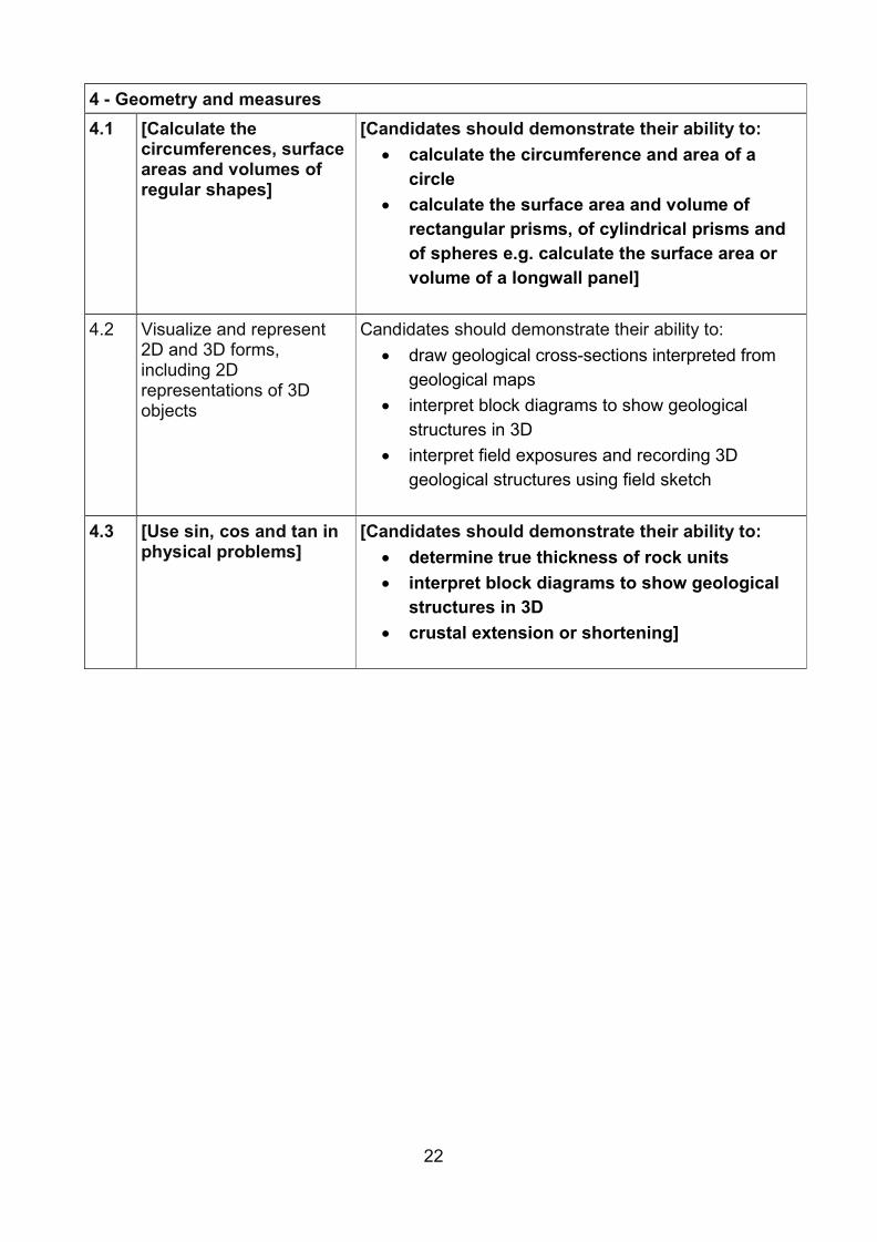
4 - Geometry and measures
4.1 [Calculate the circumferences, surface areas and volumes of regular shapes]
[Candidates should demonstrate their ability to: • calculate the circumference and area of a
circle • calculate the surface area and volume of
rectangular prisms, of cylindrical prisms and of spheres e.g. calculate the surface area or volume of a longwall panel]
4.2 Visualize and represent 2D and 3D forms, including 2D representations of 3D objects
Candidates should demonstrate their ability to: • draw geological cross-sections interpreted from
geological maps • interpret block diagrams to show geological
structures in 3D • interpret field exposures and recording 3D
geological structures using field sketch
4.3 [Use sin, cos and tan in physical problems]
[Candidates should demonstrate their ability to: • determine true thickness of rock units • interpret block diagrams to show geological
structures in 3D • crustal extension or shortening]
22

Appendix three – SI units in geology The International System of Units (Système International d'Unités), which is abbreviated as SI, is a coherent system of base units. The six which are relevant for AS and A level geology are listed below. We also list eight of the derived units (which have special names) selected from the SI list of derived units in the same source.
Base units These units and their associated quantities are dimensionally independent:
metre (m), kilogram (kg), second (s), ampere (A), kelvin (K) and mole (mol).
Some derived units with special names Frequency hertz (Hz), force newton (N), energy joule (J), power watt (W), pressure pascal (Pa), electric charge coulomb (C), electric potential difference volt (V) and electric resistance ohm (Ω).
Some non-standard units used in geology Time day (d), time year - annum (a) and mass tonne (t).
23

© Crown copyright 2016
This publication (not including logos) is licensed under the terms of the Open Government Licence v3.0 except where otherwise stated. Where we have identified any third party copyright information you will need to obtain permission from the copyright holders concerned.
To view this licence: visit www.nationalarchives.gov.uk/doc/open-government-licence/version/3email [email protected] write to Information Policy Team, The National Archives, Kew, London, TW9 4DU
About this publication: enquiries www.education.gov.uk/contactus download www.gov.uk/government/publications
Reference: DFE-00056-2016
Follow us on Twitter: @educationgovuk
Like us on Facebook: facebook.com/educationgovuk
24