Embed Size (px)
Citation preview
w _ 3_
NASA Technical Memorandum 103813
Geology, Geohydrology And Soils OfKennedy Space Center:A Review
August 1990
.,q
(NASA-TM-103813) GEOLOGY, GEOHYDROLOGY, AND
SnlLS OF NASA, KENNEDY SPACE CENTER: A
REVIEW (gionetics Corp.) 49 p CSCL O@G
G3/_6
Nqi-I0442
unclas
0310095
N/ ANational Aeronautics and
Space Administration
https://ntrs.nasa.gov/search.jsp?R=19910001129 2018-05-25T00:56:52+00:00Z

NASA Technical Memorandum 103813
Geology, Geohydrology And Soils OfKennedy Space Center:A Review
Paul A. Schmalzer, Ph.D.G. Ross Hinkle, Ph.D.
The Bionetics CorporationKennedy Space Center, Florida 32899
August1990
National Aeronautics andSpace Administration
John F. Kennedy Spaoe Center
NASA

Table of Contents
Section Page
Table of Contents .......................................................................................................................... i
Abstract ........................................................................................................................................... ii
List of Figures ............................................................................................................................... iii
Ust of Tables ................................................................................................................................. iv
Acknowledgments ........................................................................................................................ v
Introduction .................................................................................................................................... 1
Geology .......................................................................................................................................... 1
Geohydrology ............................................................................................................................. 10
Soils .............................................................................................................................................. 19
Summary ..................................................................................................................................... 25
Literature Cited ........................................................................................................................... 27
Appendix I. Descriptions of the Soil Series and Land Types on Kennedy SpaceCenter .................................................................................................................... 30
Abstract
Sediments underlying Kennedy Space Center (KSC) have accumulated in
alternating periods of deposition and erosion since the Eocene. Surface sediments are
of Pleistocene and Recent ages. Fluctuating sea levels with the alternating glacial-
interglacial cycles have shaped the formation of the barrier islands. Merritt Island is an
older landscape whose formation may have begun as much as 240,000 years ago,
although most of the surface sediments are not that old. Cape Canaveral probably dates
from <7,000 years B.P. (before present) as does the barrier strip separating Mosquito
Lagoon from the Atlantic Ocean. Merritt Island and Cape Canaveral have been shaped
by progradational processes but not continuously so, while the Mosquito Lagoon barrier
has been migrating landward.
Deep aquifers beneath KSC are recharged inland but are highly mineralized in
the coastal region and interact little with surface vegetation. The Surficial aquifer has
formed in the Pleistocene and Recent deposits and is recharged by local rainfall. Sand
ridges in the center of Merritt Island are important to its recharge. Discharge is from
evapotranspiration, seepage to canals and ditches, seepage into interior wetland
swales, and seepage into impoundments, lagoons, and the ocean. This aquifer exists in
dynamic equilibrium with rainfall and with the fresh-saline water interface. Freshwater
wetlands depend on the integrity of this aquifer, and it provides freshwater discharge to
the lagoons and impoundments.
Soils of KSC reflect the complexity of soil forming factors (parent material,
topography, time, biota) on the landscape. Numerous soil series are represented. Within
a given area, soils vary from well to poorly drained. On well drained sites of differing
ages, leaching has modified soil properties. Parent material differences (sand, loam,
clay, coquina) are also reflected in the soil pattern.
Figure 1.
Figure 2.
Figure 3.
Figure 4.
Figure 5.
Figure 6.
Figure 7.
Figure 8.
List of Figures
Page
Location of north-south and east-west geologic cross sections on KennedySpace Center .............................................................................................................. 5
North-south geologic cross section, Kennedy Space Center ............................ 6
East-west geologic cross section, Kennedy Space Center ................................ 7
Geohydrologic units on Kennedy Space Center ............................................... 11
Potential for recharge of the Surficial aquifer ..................................................... 14
Groundwater circulation in the Surficial aquifer ................................................. 15
Subsystems of the Surficial aquifer ...................................................................... 17
Chemical evolution of groundwater in the Surficial aquifer ............................. 18
iii
List of Tables
Page
Table 1. Stratigraphic units of Brevard County, Florida ....................................................... 3
Table 2. General characteristics of the aquifers on Kennedy Space Center ................. 12
Table 3. Soil and land types occurring on Kennedy Space Center ................................ 20
Table 4. Classification of Kennedy Space Center soil series ........................................... 22
Table 5. Parent material of Kennedy Space Center soil series ....................................... 24
iv
Acknowledgments
This study was conducted under NASA contracts NAS10-10285 and NAS10-
11624. We thank William M. Knott, !!1, Biological Sciences Officer, Life Sciences
Research Office, Albert M. Koller, Jr., formerly, Chief, Programs and Planning Office,
and Burton Summerfield, Pollution Control Officer, Biomedical Operations and
Research Office, for their guidance. Gary Spurlock of EG&G Florida, Inc. provided
graphics assistance. We thank Joseph Mailander and Mark Provancha for Geographic
Information System assistance and Opal Tilley and Julie Harvey for manuscript
preparation.


Introduction
Surficial geology and geologic history form the context under which the biota of
a region has developed. The barrier island complex of Merritt Island-Cape Canaveral
has a varying history of deposition and erosion with numerous geologic formations
represented. In areas of low topographic relief and abundant rainfall such as that
occupied by Kennedy Space Center (KSC), the groundwater system interacts
dynamically with the surficial geology, vegetation, and soils. Soils form in the surficial
geologic deposits. Their properties are influenced by geologic parent material,
topographic position, particularly relations to the water table, the prevailing climate, the
length of time over which they have formed, and interactions with the biota (Jenny
1941, 1980). In turn, soil properties influence the vegetation growing on a site.
In this report, we review information on the geology, geohydrology, and soils of
KSC. Our focus is on those properties of importance to the biota, particularly
vegetation, of the area. This is one in a series of reports summarizing information on
current environmental conditions on KSC. Other reports will examine quantitative
vegetation-soil relationships.
Geology
Merritt Island together with the adjacent Cape Canaveral form a barrier island
complex. Topographic relief is slight; elevation ranges from sea level to about 3 m (10
ft) in the inland areas of Merritt Island and to slightly over 6 m (20 ft) on Cape
Canaveral and the recent dunes. The topography is marked by a sequence of ridges
and swales reflecting relict beach ridges.
Fenneman (1938) mapped the area as part of the East Florida Flatwoods
Region of the Coastal Plain Province. Brooks (1981b) mapped the area as the Cape
Canaveral section of the Central Atlantic Coast Strip within the Eastern Flatwoods
District.
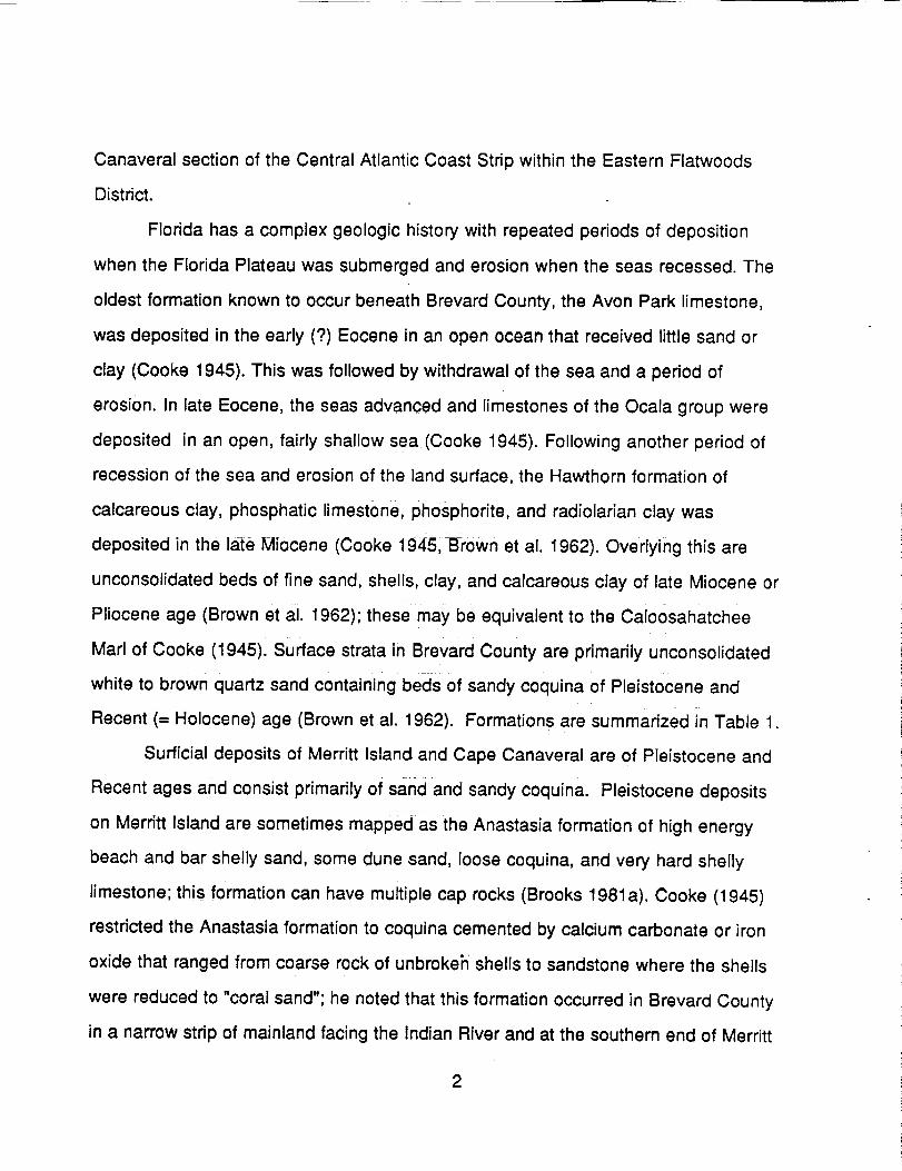
Florida has a complex geologic history with repeated periods of deposition
when the Florida Plateau was submerged and erosion when the seas recessed. The
oldest formation known to occur beneath Brevard County, the Avon Park limestone,
was deposited in the early (?) Eocene in an open ocean that received little sand or
clay (Cooke 1945). This was followed by withdrawal of the sea and a period of
erosion. In late Eocene, the seas advanced and limestones of the Ocala group were
deposited in an open, fairly shallow sea (Cooke 1945). Following another period of
recession of the sea and erosion of the land surface, the Hawthorn formation of
calcareous clay, phosphatic limestone, phosphorite, and radiolarian clay was
deposited in the late Miocene (Cooke 1945, Brown et al. 1962). Overlying this are
unconsolidated beds of fine sand, shells, clay, and calcareous clay of late Miocene or
Pliocene age (Brown et al. 1962); these may be equivalent to the Calo0sahatchee
Marl of Cooke (1945). Surface strata in Brevard County are primarily unconsolidated
white to brown quartz sand containing beds of sandy coquina of Pleistocene and
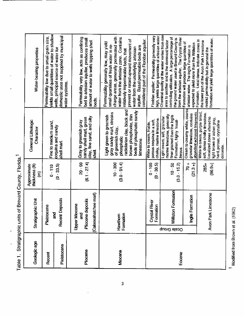
Recent (-- Holocene) age (Brown et al. 1962). Formations are summarized in Table 1.
Surficial deposits of Merritt Island and Cape Canaveral are of Pleistocene and
Recent ages and consist primarily of sand and sandy coquina. Pleistocene deposits
on Merritt Island are sometimes mapped as the Anastasia formation of high energy
beach and bar shelly sand, some dune sand, loose coquina, and very hard shelly
limestone; this formation can have multiple cap rocks (Brooks 1981a). Cooke (1945)
restricted the Anastasia formation to coquina cemented by calcium carbonate or iron
oxide that ranged from coarse rock of unbrokeh- shells to sandstone where the shells
were reduced to "coral sand"; he noted that this formation occurred in Brevard County
in a narrow strip of mainland facing the Indian River and at the southern end of Merritt
2
0
0
>
tn
0
t-
O
¢-O.
O_.B
_0
0
,o
e-
0 o
m
0c-oo
<--
c-
._o
o.t_
o
._o
0
"@o_o E
-_'_E_
._:_ _
_.__ _ o _
E_•m _1
°_
tr. _
o it)
|i
oov
e- o
•-_ _ o_o oIi, •
fr
o
• _orr 0,.
o_p0 0,_
o'S
• e- •>m_
.'-oi0..o ._
_, 00 "_t_
=E
0}1-0 m e-
c_o
v
• e-
o
8D,.
E_,_ ,o ,_
-1- ,, dn0JO eleoO '_
0
Ill
C'J
0'_
v
CO
Eo
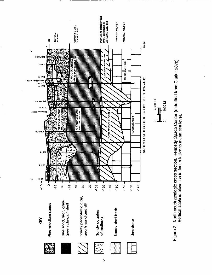
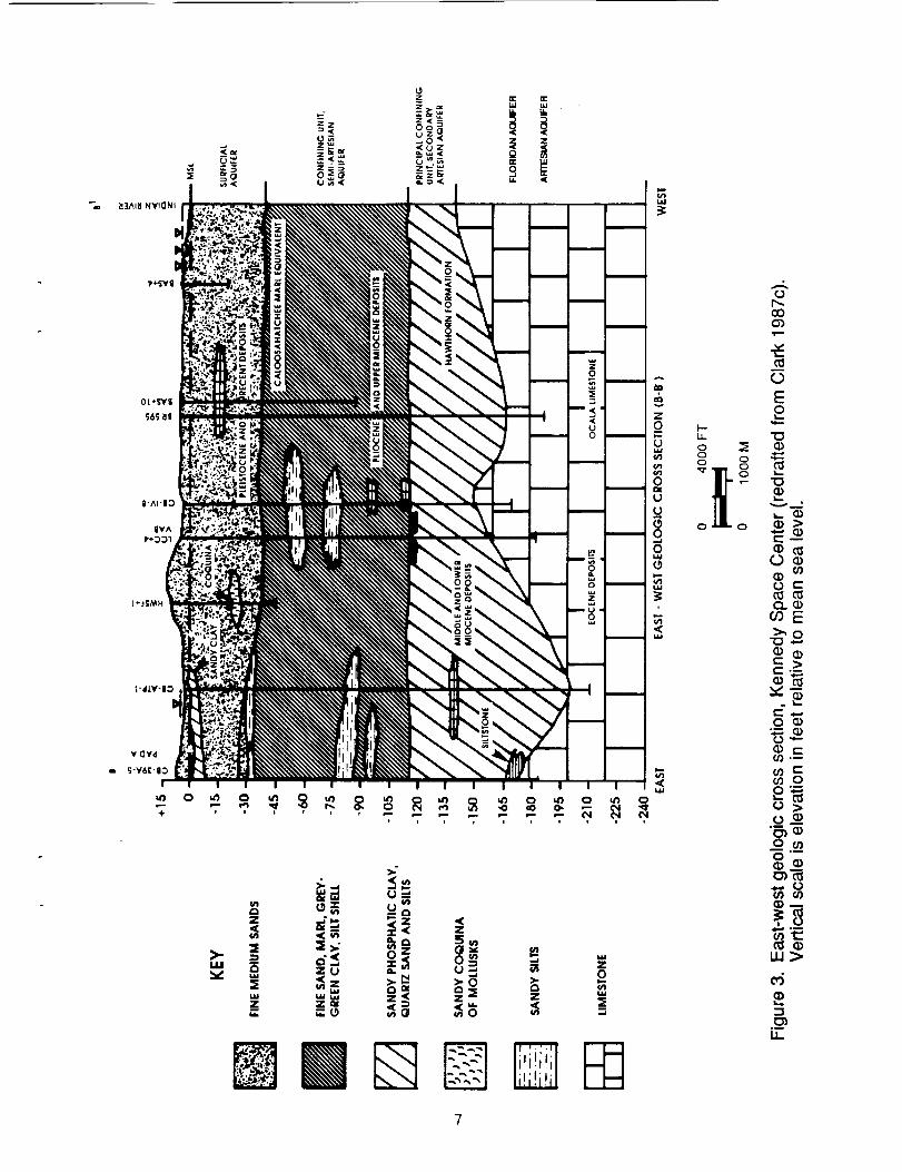
Island. Cape Canaveral and the active barrier beach are mapped as Holocene
undifferentiated deposits of sand, shell, clay, marl, or peat (Brooks 1981a). These
overlay upper Miocene or Pliocene deposits of unconsolidated beds of fine sand,
shells, clay, and calcareous clay (Brown et al. 1962). In the northern section of Merritt
Island, the Pliocene Tamiami formation has been identified; it includes a narrow band
of shelly conglomerate or medium hard limestone (Edward E. Clark Engineers-
Scientists, Inc. 1987c) [hereafter referenced as Clark]. Under these are the Hawthorn
formation of Miocene age composed of calcareous clay, sandy phosphatic limestone,
phosphorite, and radiolarian clay (Brown et al. 1962). Within KSC, two thin,
discontinuous conglomerate limestone/sandstone beds occur within the Hawthorn
formation (Clark 1987c). Below these are a series of limestones of Eocene age that
include the Ocala group and the Avon Park limestone and also constitute the Floridan
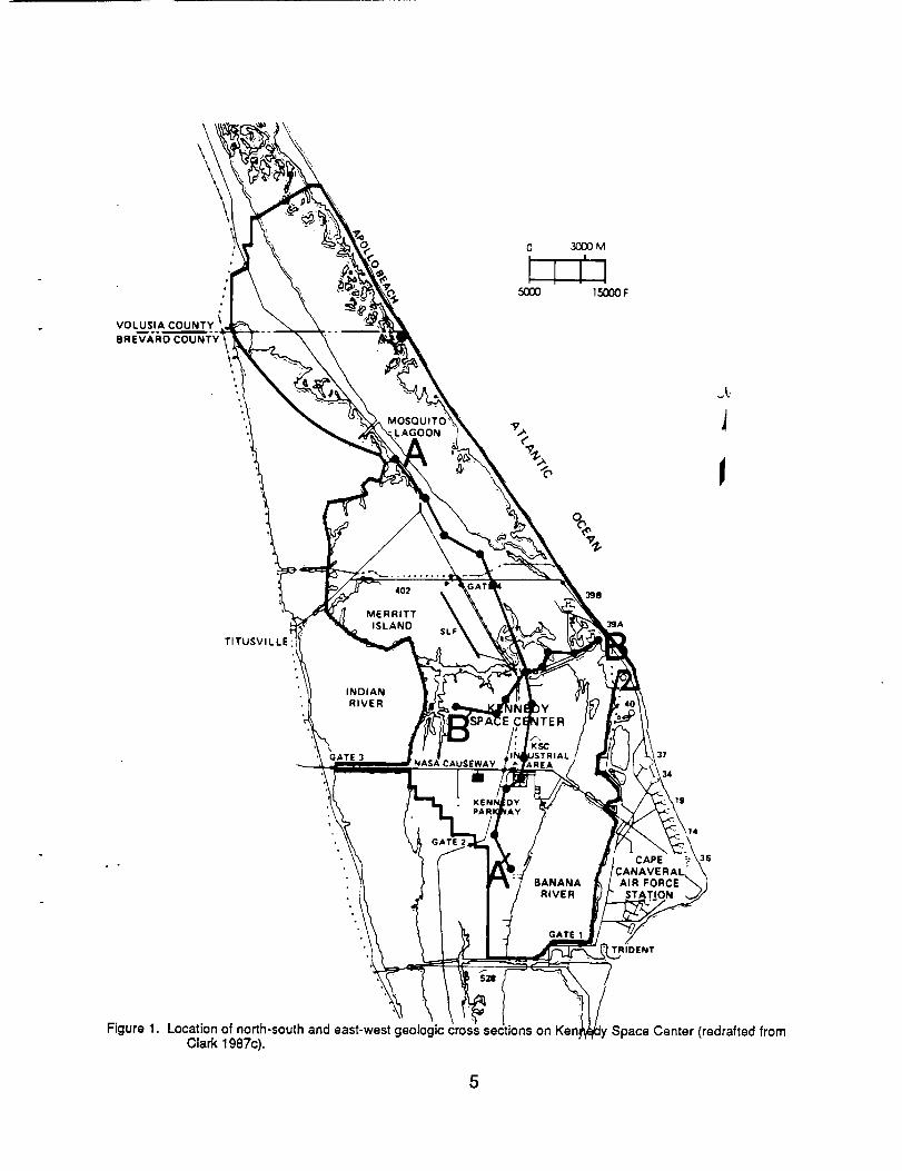
aquifer (Brown et al. 1962). Geologic cross sections for Merritt Island are given in
Figures 1,2, and 3; these figures were derived from data from numerous borings
conducted in developing the space center (NASA 1986).
In addition to the sequences of sediments of varying age, the surface of Florida
is marked by a series of terraces and former shorelines of varying ages. The number
and ages of the terraces has been a matter of debate (Fenneman 1938, Cooke 1945,
MacNeil 1950, AIt and Brooks 1965, Healy 1975). As summarized by Healy (1975),
eight terraces are recognized: Hazelhurst (215-270 ft), Coharie (170-215 ft),
Sunderland (100-170 ft), Wicomico (70-100 ft), Penholoway (42-70 ft), Talbot (25-42
ft), Pamlico (5-25 ft), and Silver Bluff (0-10 ft). Cooke (1945) considered these terraces
to represent different interglacial periods of high sea level during the Pleistocene.
However, AIt and Brooks (1965) concluded that the highest terrace (Hazelhurst, 215-
270 ft) was probably of Miocene age, the terrace at 90-100 ft (Wicomico) was probably
Pliocene, and the distinct shoreline at 25-30 ft (Pamlico) was definetly Pleistocene and
4
\
VOLUSIA
BREVARD
LAGOON
,500O
\
3DOOM
150O0F
\
J
TITUSVILLE
402
MERRITT
ISLAND
\SLF
398
3¢JA
INDIAN
RIVER
GATE 3NASA CAUSEWAY
3"7
34
19
BANANA
RIVER
GATE 1
CAPE
AIR FORC EL"_
TRIDENT
36
Figure 1. Location of north-south and east-west geologic cross sections on KerClark 1g87c).
Space Center (redrafted from
5
:E
I--
Z--
u_
Z
u. LIJ I_I
w<--_ Q
m 0"-
_ _ _ ,,
>- = ._ _'_ _ :" _ "00 _-*" 0 ®
c c_ o_ o-- 0•"_ O_ (nO" (nO (n
@
0,amt_
@
A
Z_o
u.l
i°(5
±
oZ
0
0
E
q_
o-_
_ 0
0
_ocJ'._
0 if)
0
r- (J
0 q)
Z>
o_
L_.
83AI8 NYIONi
L +:ISMHUm .0
o_
_ _ _ _ --
.m
oO
o_v
z
=ou
0Ol
lj
u
0wJ
+m
,<ELi
E
v--_-- <_
0 e-
_'0-_.,Q_ (D_'-
0 _0_
o0 00"_
.__U-
may have been occupied repeatedly. Healy (1975) mapped Merritt Island and Cape
Canaveral as belonging to the Silver Bluff Terrace, while the Atlantic Coastal Ridge on
the adjacent mainland belongs to the Pamlico Terrace.
During the Pleistocene, repeated glaciation of the northern hemisphere
produced fluctuations in sea level (see Bowen 1978), while sea level rose with glacial
retreat. At the maximum of the Wisconsinan glaciation (ca. 18,000 yr B.P.[before
present]) sea levels were on the order of 100 m lower than present and substantial
additional areas were exposed along the Atlantic and Gulf Coasts including Florida
(Delcourt and Delcourt 1981).
The Cape CanaveraI-Merritt Island barrier island complex is unique along the
Florida coast; it is not associated with rivers or former deltas as are capes on the coast
of the Carolinas (Hoyt and Henry 1970). White (1958, 1970) described this as a
prograding barrier island complex. He considered Cape Canaveral to be the result of
the southward (longshore) growth of an original cape at the site of the present False
Cape. The eastern edge of Merritt Island at its contact with M0squito Lagoon and the
Banana River forms a relict cape coaxial with False Cape. Multiple dune ridges
parallel to the present shore inland On Merritt Island apparently represent successive
stages in this growth. White (1958, 1970) thought that this succession of cape
formations was probably structurally controlled by some bedrock feature that
influenced the southward movement of sediments along the coast. Hydrologic factors
may also be involved. Brown et al. (1962) showed that the depth to the Eocene
limestone formation below the land surface forms a ridge-like structure roughly
conforming to the shape of Cape Canaveral, which may be the structure responsible
for the cape formation. Chaki (1974) distinguished eleven distinct beach ridge sets on
Cape Canaveral and suggested that periods of deposition and erosion have
alternated; elevation of older ridges had been reduced by the dissolution of shell
8
material. Brooks (1972) states that the geologic history of the Merritt Island-Cape
Canaveral barrier islands is complex, and this is not a simple progradational feature
developed during recent times. The older portion of Merritt Island consists of beach
deposits > 240,000 years old (Brooks 1972). Previous dating of fossil beach rock,
shells, or coquina (Osmond et al. 1970) gave recent ages on the current barrier beach,
ca. 30,000 BP on Merritt Island, and ca. 110,000 BP on the adjacent mainland.
Changes of sea levels from glacial eustatic ice water volume have occurred, and the
Merritt Island-Cape Canaveral complex has grown by successive increments (Brooks
1972). Brooks (1981a) mapped Cape Canaveral as of Holocene age, mostly less than
4,500 BP, but Merritt Island as Pleistocene. He earlier suggested that the formation of
the Cape Canaveral peninsula began about 7,000 years ago (Brooks 1972).
Successively older landscapes occur westward on Merritt Island. Brooks (1972)
related the western part of Merritt Island to the Yarmouth glacial period (ca. 240,000
years ago) and the eastern part to the Sangamon period (110,000 + 20,000 years
ago). Erosion has reduced the western side of Merritt Island to a nearly level plain
(Brown et al. 1962) with karst features such as sinkholes not present on the eastern
part of the island (Brooks 1972).
Mehta and Brooks (1973) considered the geologic history of Mosquito Lagoon
and the barrier beach separating it from the Atlantic Ocean. They state that the
seaward barrier initiated at the same time as the Cape Canaveral peninsula about
7,000 years ago. Unlike Cape Canaveral, the history of this barrier beach is marked by
erosion, overwash, and landward migration rather than progradation; these processes
continue today. They document that there have been five separate inlets between
Mosquito Lagoon and the Atlantic Ocean within the last 6,000 to 7,000 years. The most
recent one was in the vicinity of Turtle Mound and closed more than 1,500 years ago.
Since then, Mosquito Lagoon has been accumulating fine grain sedimentsl
9
In the southern Indian River Lagoon, Bader and Parkinson (1990) documented
the Holocene flooding of a Pleistocene topographic depression (paleolagoon) at
about 5,000 - 6,000 years B.P.
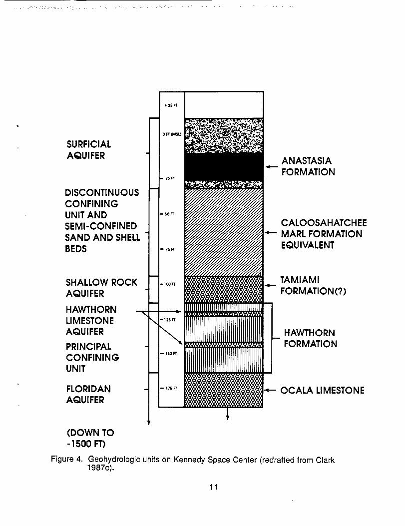
Geohydrology
The geologic structure and composition of the Merritt Island-Cape Canaveral
barrier island complex together with climatic conditions form the basis for the
hydrology of the system. Groundwater hydrology of KSC has been the subject of
recent studies (Edward E. Clark Engineers-Scientists, Inc. 1985, 1987a,b,c) [hereafter
referenced as Clark]; the discussion that follows is based primarily on the areawide
survey (Clark 1987c).
General characteristics of the groundwater system are given in Figure 4 and
Table 2. The principal artesian aquifer beneath KSC is the Floridan aquifer which
occurs within the Ocala limestones. Recharge areas for this aquifer are the high ridges
of central Florida. This is a large and productive aquifer; however, in the coastal areas,
as beneath KSC, the water is highly mineralized. This aquifer is confined by the silts
and clays of the Hawthorn formation in most places. Secondary artesian aquifers
occur within the Hawthorn formation and the Caloosahatchee Marl Equivalent. The
Hawthorn Limestone aquifer is associated with thin, discontinuous beds of limestone,
sandstone, and sand within the silts and clays of the Hawthorn formation. It is
recharged by upward leakage from the Floridan aquifer. The Shallow Rock aquifer is
associated with beds of partially consolidated shelly quartz sand with silt and grey clay
and some medium hard limestone of the Tamiami formation or Caloosahatchee Marl
Equivalent. Recharge is by upward leakage from the Floridan aquifer. The Semi-
artesian Shell and Sand Bed aquifer is associated with minor, discontinuous sand and
10
SURFICIALAQUIFER
DISCONTINUOUSCONFININGUNIT ANDSEMI-CONFINEDSAND AND SHELLBEDS
ANASTASIAFORMATION
CALOOSAHATCHEEMARL FORMATIONEQUIVALENT
SHALLOW ROCKAQUIFER
HAWTHORNLIMESTONEAQUIFER
PRINCIPALCONFININGUNIT
FLORIDANAQUIFER
TAMIAMI
FORMATION(?)
HAWTHORNFORMATION
OCALA LIMESTONE
(DOWN TO- 1500 FT)
Figure 4. Geohydrologic units on Kennedy Space Center (redrafted from Clark1987c).
11

0
(I)
.c
rn,_
09 •
Y
0
(I)°_
,_o
c-
o (.0._o09-t-O
(J
(J
C
0
h-
•o" (/)0J._ "0
_o
E__
0=
"_=u _
.-_'_o_
__E_
LL 0 0_ --
-o ___-
_o_
o •wO<
o
O.
33
0
(I)
v
E"_o
o__
,<
•°oO< _ --_
O
o0
en
_E
I !
_ N_'
• ._
O - e'-
6''0O .
S_Oo
_ _'_
Ow
nm
O
•'--O0
g
"oo_N-0 r- 00 _
_N_N
n'._._ o 0
•_oc -
8"g
A
g_
c_
oE
_m
12
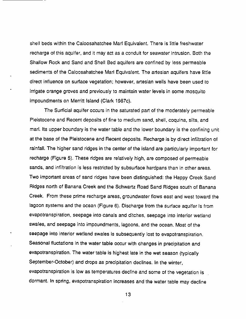
shell beds within the Caloosahatchee Marl Equivalent. There is little freshwater
recharge of this aquifer, and it may act as a conduit for seawater intrusion. Both the
Shallow Rock and Sand and Shell Bed aquifers are confined by less permeable
sediments of the Caloosahatchee Marl Equivalent. The artesian aquifers have little
direct influence on surface vegetation; however, artesian wells have been used to
irrigate orange groves and previously to maintain water levels in some mosquito
impoundments on Merritt Island (Clark 1987c).
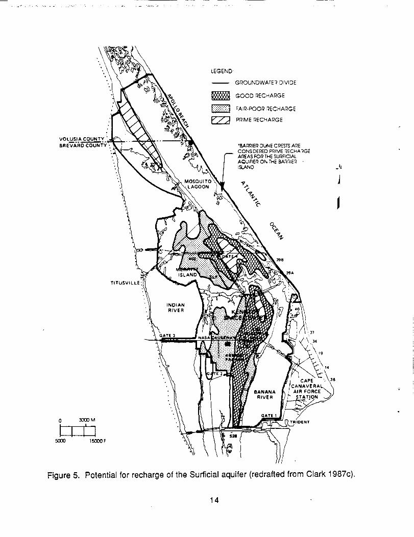
The Surficial aquifer occurs in the saturated part of the moderately permeable
Pleistocene and Recent deposits of fine to medium sand, shell, coquina, silts, and
marl. Its upper boundary is the water table and the lower boundary is the confining unit
at the base of the Pleistocene and Recent deposits. Recharge is by direct infiltration of
rainfall. The higher sand ridges in the center of the island are particularly important for
recharge (Figure 5). These ridges are relatively high, are composed of permeable
sands, and infiltration is less restricted by subsurface hardpans than in other areas.
Two important areas of sand ridges have been distinguished: the Happy Creek Sand
Ridges north of Banana Creek and the Schwartz Road Sand Ridges south of Banana
Creek. From these prime recharge areas, groundwater flows east and west toward the
lagoon systems and the ocean (Figure 6). Discharge from the surface aquifer is from
evapotranspiration, seepage into canals and ditches, seepage into interior wetland
swales, and seepage into impoundments, lagoons, and the ocean. Most of the
seepage into interior wetland swales is subsequently lost to evapotranspiration.
Seasonal fluctations in the water table occur with changes in precipitation and
evapotranspiration. The water table is highest late in the wet season (typically
September-October) and drops as precipitation declines. In the winter,
evapotranspiration is low as temperatures decline and some of the vegetation is
dormant. In spring, evapotranspiration increases and the water table may decline
13
\
VOLUSIA COUNTY
BREVARD COUNTY
".
.
\
__>'
MOSQUITOLAGOON
LEGEND:
GROUNDWATER DIVIDE
GOOD RECHARGE
FAIR-POOR RECHARGE
PRIME RECHARGE
•BAr_IER DUNE CRESTS ARECONS_DEi_ED Pi_IME r_ECHAi;GEAr_AS FOR THE SURFICIALAQUIFIE_ ON Tile BAR_IE_ISLAND
%
J
TITUSVILLE
ISLANr
398
3¢JA
INDIANRIVER
GATE 337
0 3000M
5OOO 15000 F
BANANARIVER
GATE 1
\\\14
, CAPE ::CANAVERALAIR FORCE
_TRIDENT
Figure 5. Potential for recharge of the Surficial aquifer (redrafted from Clark 1987c).
14
('.I=I) 13A_'I Y_$ NY31AI O1 3A11¥'13_ NOIIYAili
>-uJ
].5
during spring droughts. See Mailander (1990) for further discussion of precipitation
and evapotranspiration patterns. The Surficial aquifer is extremely important since it
supports the freshwater wetlands and provides fresh groundwater discharge to the
surrounding subsaline lagoons (Clark 1987c).
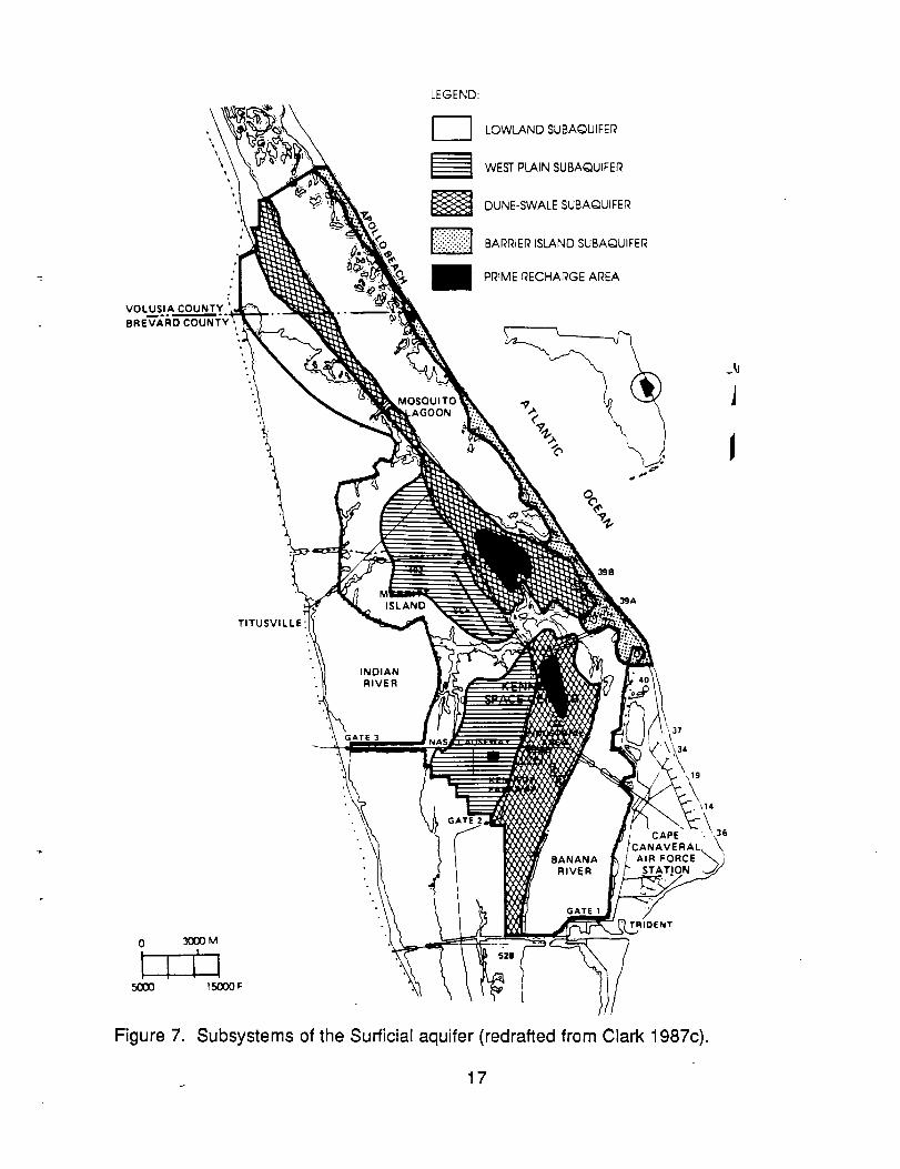
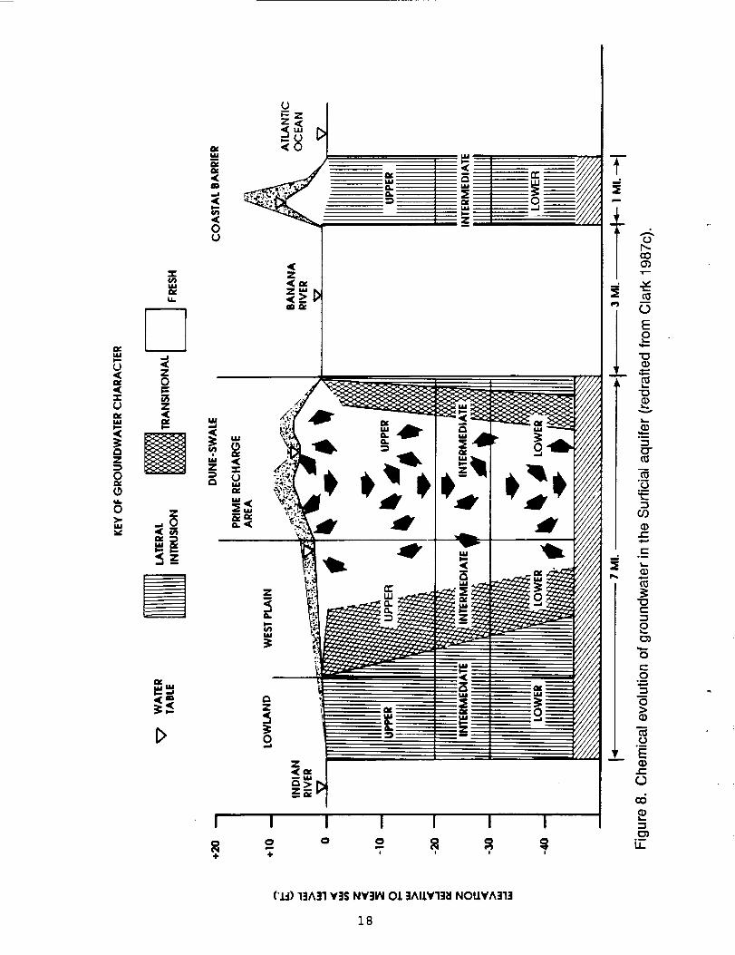
T.he Surficial aquifer can be divided into several subsystems (Figure 7). The
Barrier Island subsystem has a lens of freshwater less than 10 ft (3 m) thick on top of
intruded saline water (Figure 8). The primary dune acts as the prime recharge area.
Shallow groundwater flows east of the ridge to the Atlantic Ocean and west to Banana
River, Mosquito Lagoon, or swales; at depth (> 20 ft [6.1 m]) flow is to the Atlantic
Ocean. The Dune-Swale subsystem (Figures 7, 8) includes the high ridges with
permeable sand that favor recharge. This is the only area where the freshwater
recharge of the deeper layers of the surficial aquifer occurs (Figure 6). During most of
the year, shallow groundwater discharges to the swales. At the beginning of the rainy
season after the spring drought, swales collect water and remain flooded; lateral and
downward seepage from the swales helps to recharge the groundwater. In areas of
pine flatwoods and swales, topography is lower and most soils have well developed
humic hardpans (spodic horizon, Bh layer) that restrict infiltration. During heavy rains,
water perches above the hardpan and infiltrates slowly into the Surficial aquifer. This
increases evapotranspiration and reduces recharge relative to the prime recharge
areas. In the West Plain and Lowland subsystems (Figure 7, 8), the water table is
typically within 3 ft (0.9 m) of the land surface, evapotranspiration losses are high, and
the dispersed saline water interface renders water quality variable. In the West Plain
south of Banana Creek, a limerock "hardpan" replaces the humic hardpan of the
Dune-Swale flatwoods. Along the coastlines, the Surficial aquifer contacts the saline
water of the Atlantic Ocean and the brackish lagoons. Seawater intrusion occurs as a
wedge at the base of the Surficial aquifer since seawater is denser than fresh. The
16
\
VOLUSIA COUNTY
8REVARD COUNTY *
,,..
LEGEND:
MOSOUITC.AGOON
LOWLAND SUBAQUIFER
WEST PLAIN SUBAQUIFER
DUNE-SWALE SUBAQUIFER
BARRIER ISLAND SUBAQUIFER
PRIME RECHARGE AREA
\
\
J
TITUSVILLE
398
39A
INDIANRIVER
GATE 337
19
0 3000M
500O )5000
BANANARIVER
GATE I
CAPE : \: ',36c \
AIR FORCE
TRIDENT
Figure 7. Subsystems of the Surficial aquifer (redrafted from Clark 1987c).
17
{.)_z
'="
U
w
±f,,.cO
I I I I i I I
° o o o _ _÷ 4- ' ' '
{'.L-I) l:]A31 ¥35 N¥31_i Ol 3AIJ,¥'I3_I NOIJ.YA:JI:J
3.8
position of the fresh-saline water interface fluctuates; when water levels are low saline
water moves inland, and when they are high saline water is forced out, producing a
dynamic system.
Soils
Soils differ through the interaction of several factors: climate, parent material,
topography, organisms, and time (Jenny 1941, 1980). The soils of KSC are mapped in
the soil surveys for Brevard County (Huckle et al. 1974) and Volusia County (Baldwin
et al. 1980), and the resulting soil pattern is complex. Numerous soil series and land
types are represented (Table 3), and these include representatives of many of the
major soil groups (Table 4). This is interesting since Merritt Island is a relatively young
landscape and one formed from coastal plain deposits. Some differences in soil
parent material do occur (Table 5). In particular, soils that formed in deposits over
limestone, coquina, or other alkaline material differ greatly in properties from those
formed in sand. Textural differences in parent material such as that between loam or
clay material and sand also influence soil properties.
Not all of the Cape CanaveraI-Merritt Island complex is of the same age, as
discussed earlier. Soils on Cape Canaveral, False Cape, and the barrier island
section on the east side of Mosquito Lagoon are younger than those of Merritt Island
and therefore have had less time to weather. Predominant well drained soil series
(e.g., Palm Beach, Canaveral) in these areas still retain shell fragments in the upper
layers, while those inland on Merritt Island (e.g., Paola, Pomello) do not. The
presence of shell fragments influences soil nutrient levels, particularly calcium and
magnesium, and pH. The eastern and western sections of Merritt Island differ in age.
The eastern section of Merritt Island inland to about State Route 3 has a marked ridge-
swale topography presumably retained from its formation as a barrier island, while
19 ¸
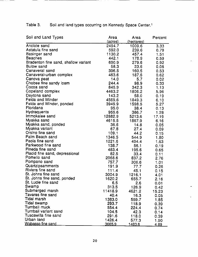
Table 3. Soil and land types occurring on Kennedy Space Center. 1
Soil and Land Types
Anclote sandAstatula fine sandBasinger sandBeachesBradenton fine sand, shallow variantBulow sandCanaveral sandCanaveral-urban complexCanova peatChobee fine sandy loamCocoa sandCopeland complexDaytona sandFelda and WinderFelda and Winder, pondedFloridanaHydraquentsImmokalee sandMyakka sandMyakka sand, pondedMyakka variantOrsino fine sandPalm Beach sandPaola fine sandParkwood fine sandPineda fine sandPlacid fine sand, depressionalPomello sandPompano sandQuartzipsammentsRiviera fine sandSt. Johns fine sandSt. Johns fine sand, pondedSt. Lucie fine sandSwampSubmerged marshTavares fine sandTidal marshTidal swampTurnball muckTurnbali variant sandTuscawilla fine sandUrban landWabassofine sand
Area Area PercentIacre.s) (heq_re_)2494.7 1009.6 3.33
592.0 239.6 0.791130.2 457.4 1.51
442.1 178.9 0.59690.9 279.6 0.92
58.3 23.6 0.08396.5 160.5 0.53463.6 187.6 0.62
14.0 5.7 0.02244.4 98.9 0.33845.9 342.3 1.13
4463.2 1806.2 5.96143.2 58.0 o. 19
4569.6 1849.3 6.103949.9 1598.5 5.27
95.0 38.4 0.13955.6 386.7 1.28
12882.9 5213.6 17.194615.5 1867.9 6.16
36.6 14.8 0.0567.8 27.4 0.09
109.t 44.2 o. 151346.5 544.9 1.801221.6 494.4 1.63
138.7 56.1 0.19483.4 195.6 0.65
82.5 33.4 o. 112068.6 837.2 2.76
757.7 306.6 1.01191.9 77.7 0.26111.4 45.1 0.15
3004.9 1216.1 4.011620.2 655.7 2.16
6.5 2.6 0.01313.5 126.9 0.42
11418.9 4621.2 15.2340.4 16.3 0.05
1383.0 559.7 1.85293.7 118.9 0.39554.4 224.4 0.74104.5 42.3 o. 14291.6 118.0 0.39
1426.4 577.3 1.903665.9 1483,6 4.89
2o

Table 3. (continued)
Soil and Land Types
Winder loamy sandGravel pits and quarriesSpoil banksDikesMade land and other landTransportation
Area Area Percent(acres_ ('hectares)
6.9 2.8 0.01116.5 47.1 0.16364.5 147.5 0.49
2316.1 937.3 3.0921.2 8.5 0.O3
2333.2 944.2 3.11
Total 74945,6 30330,1
1Dataderivedfromdigitizedsoilmap,basemapsbyHuckleetal.(1974)andBaldwinet al.(1980).
21
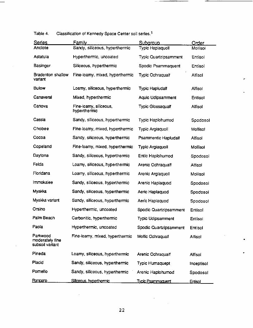
Table 4.
SeriesAnclote
Astatula
Basinger
Bradenton shallowvariant
Bulow
Canaveral
Canova
Cassia
Chobee
Cocoa
Copeland
Daytona
Felda
Floridana
Immokalee
Myakka
Myakka variant
Orsino
Palm Beach
Paola
Parkwoodmoderately finesubsoil variant
Pineda
Placid
Pomello
Classification of Kennedy Space Center soil
FamilySandy, siliceous, hyperthermic
Hyperthermic, uncoated
Siliceous, hyperthermic
Fine-loamy, mixed, hyperthermic
Loamy, siliceous, hyperthermic
Mixed, hyperthermic
Fine-loamy, siliceous,hyperthermic
Sandy, siliceous, hyperthermic
Fine-loamy, mixed, hyperthermic
Sandy, siliceous, hyperthermic
Fine-loamy, mixed, hyperthermic
Sandy, siliceous, hyperthermic
Loamy, siliceous, hyperthermic
Loamy, siliceous, hyperthermic
Sandy, siliceous, hyperthermic
Sandy, siliceous, hyperthermic
Sandy, siliceous, hyperthermic
Hyperthermic, uncoated
Carbonitic, hyperthermic
Hyperthermic, uncoated
Fine-loamy, mixed, hyperthermic
Loamy, siliceous, hyperthermic
Sandy, siliceous, hyperthermic
Sandy, siliceous, hyperthermic
series. 1
SubgroupTypic Haplaquoll
Typic Quartzipsamment
Spodic Psammaquent
Typic Ochraqualf
Typic Hapludalf
Aquic Udipsamment
Typic Glossaqualf
Typic Haplohumod
Typic Argiaquoll
Psammentic Hapludalf
Typic Argiaquoll
Entic Haplohumod
Arenic Ochraqualf
Arenic Argiaquoll
Arenic Haplaquod
Aeric Haplaquod
Aeric Haplaquod
Spodic Quartzipsamment
Typic Udipsamment
Spodic Quartzipsamment
Mollic Ochraqualf
OrderMollisol
Entisol
Entisol
Alfisol
Alfisol
Entisol
Alfisol
Spodosol
Mollisol
Alfisol
Mollisol
Spodosol
Alfisol
Mollisol
Spodosol
Spodosol
Spodosol
Entisol
Entisol
Entisol
Alfisol
Arenic Ochraqualf
Typic Humaquept
Arenic Haplohumod
Alfisol
Inceptisol
Spodosol
22

Table 4.
SeriesRiviera
St. Johns
St. Lucie
Tavares
Turnbull
Tumbull variant
Tuscawilla
Wabasso
Winder
(continued)
FamilvLoamy, siliceous, hyperthermic
Sandy, siliceous, hyperthermic
Hyperthermic, uncoated
Hyperthermic, uncoated
Clayey over sandy or sandy-skeletal, montmorillonitic, nonacid,hyperthermic
Mixed, hyperthermic
Fine-loamy, mixed, hyperthermic
Sandy over loamy, siliceous,hyperthermic
Fine-loamy, siliceous,t'_oerthem'lc
SubarouDArenic Glossaqualf
Typic Haplaquod
Typic Quartzipsamment
Typic Quartzipsamment
Typic Hydraquent
Aqulc Udipsamment
Typic Ochraqualf
Alfic Haplaquod
Typic Glossaqualf
....OrderAlfisol
Spodosol
Entisol
Entisol
Entisol
Entisol
Alfisol
Spodosol
Alfisol
1 Classification from Huckle et al. (1974) and Baldwin et al. (1980).
23
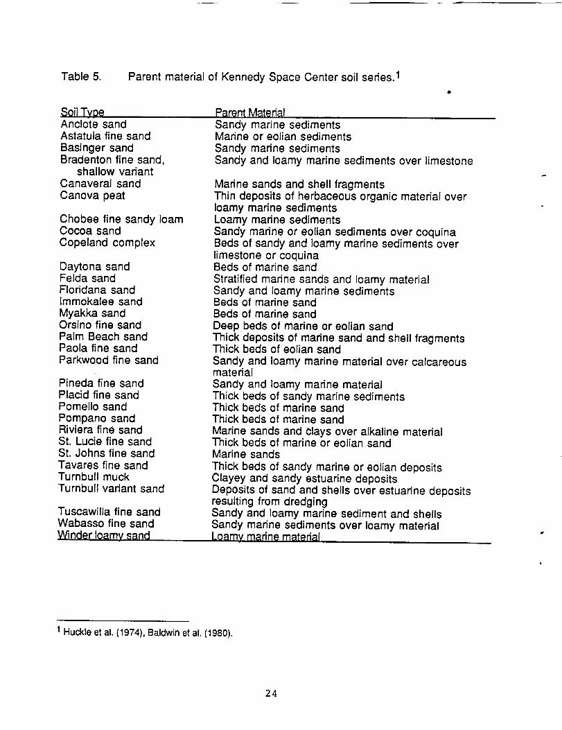
Table 5. Parent material of Kennedy Space Center soil series. 1
Soil TvoeAnclote sandAstatula fine sand
Basinger sandBradenton fine sand,
shallow variantCanaveral sandCanova peat
Chobee fine sandy loamCocoa sand
Copeland complex
Daytona sandFelda sandFloridana sandImmokalee sandMyakka sandOrsino fine sandPalm Beach sandPaola fine sandParkwood fine sand
Pineda fine sandPlacid fine sandPomello sandPompano sandRiviera fine sandSt. Lucie fine sandSt. Johns fine sandTavares fine sandTurnbull muckTurnbull vadant sand
Tuscawilla fine sandWabasso fine sandWinder loamy sand
P_rept,MatedalSandy marine sedimentsMarine or eolian sedimentsSandy marine sedimentsSandy and loamy marine sediments over limestone
Marine sands and shell fragmentsThin deposits of herbaceous organic material overloamy marine sedimentsLoamy marine sedimentsSandy marine or eolian sediments over coquinaBeds of sandy and loamy marine sediments overlimestone or coquinaBeds of marine sandStratified marine sands and loamy materialSandy and loamy marine sedimentsBeds of marine sandBeds of marine sand
Deep beds of marine or eolian sandThick deposits of marine sand and shell fragmentsThick beds of eolian sandSandy and loamy marine material over calcareousmatedalSandy and loamy marine materialThick beds of sandy marine sedimentsThick beds of marine sandThick beds of marine sandMarine sands and Clays over alkaline materialThick beds of marine or eolian sandMarine sands
Thick beds of sandy marine or eolian depositsClayey and sandy estuarine depositsDeposits of sand and shells over estuarine depositsresulting from dredgingSandy and loamy marine sediment and shellsSandy marine sediments over loamy materialLoamv marine materi_,l
1 Huckle et al. (1974), Baldwin et al. (1980).
24
west of State Route 3, the island is flatter, without obvious ridges and swales probably
due to the greater age of this topography.
Differences in age and parent material account for some soil differences, but on
landscapes of Merritt Island with similar age, topography has a dramatic effect on soil
formation. Relatively small elevation changes cause dramatic differences in the
position of the water table that, in turn, affect leaching, accumulation of organic matter,
and formation of soil horizons. In addition, proximity to the lagoon systems influences
soil salinity.
The major soil series and land types on KSC are discussed in Appendix I based
on their general characteristics and occurrence on the KSC landscape. Quantitative
soil data will be discussed in following reports.
Summary
1. Sediments underlying KSC have accumulated in alternating periods of
deposition and erosion since the Eocene. Surface sediments are of Pleistocene and
Recent ages. Fluctuating sea levels with the alternating glacial-interglacial cycles have
shaped the formation of the barrier islands. Merritt Island is an older landscape whose
formation may have begun as much as 240,000 years ago, although most of the
surface sediments are not that old. Cape Canaveral probably dates from <7,000 years
B.P. as does the barrier strip separating Mosquito Lagoon from the Atlantic Ocean.
Merritt Island and Cape Canaveral have been shaped by progradational processes
but not continuously so, while the Mosquito Laggon barrier has been migrating
landward.
2. Deep aquifers beneath KSC are recharged inland but are highly mineralized
in the coastal region and interact little with surface vegetation. The surficial aquifer has
formed in the Pleistocene and Recent deposits and is recharged by local rainfall. Sand
25
ridges in the center of Merritt Island are important to its recharge. Discharge is from
evapotranspiration, seepage to canals and ditches, seepage into interior wetland
swales, and seepage into impoundments, lagoons, and the ocean. This aquifer exists
in dynamic equilibrium with rainfall and with the fresh-saline water interface.
Freshwater wetlands depend on the integrity of this aquifer, and it provides freshwater
discharge to the lagoons and impoundments.
3. Soils of KSC reflect the complexity of soil forming factors (parent material,
topography, time, biota) on the landscape. Numerous soil series are represented.
Within a given area, soils vary from well to poorly drained. On well drained sites of
differing ages, leaching has modified soil properties. Parent material differences
(sand, loam, clay, coquina) are also reflected in the soil pattern.
26
Literature Cited
AIt, D. and H.K. Brooks. 1965. Age of the Florida marine terraces. Journal of Geology73:406-411.
Bader, S. F. and R. W. Parkinson. 1990. Holocene evolution of Indian River Lagoon inCentral Brevard County, Florida. Florida Scientist 53:204-215.
Baldwin, R., C.L. Burch, R.B. Hinton, H.H. Huckle, P. Nichols, F.C. Watts, and J.A.Wolfe. 1980. Soil survey of Volusia County, Florida. USDA Soil ConservationService, Washington, D.C. 207 pp. and maps.
Bowen, D.Q. 1978. Quaternary geology: a stratigraphic framework for multidisciplinarywork. Pergamon Press. New York. 221pp.
Brooks, H.K. 1972. Geology of Cape Canaveral. Pp. 35-44. In: T.E. Garner (ed.).Space-age geology. Southeastern Geology Society. Tallahassee, Florida.
Brooks, H.K. 1981a. Geologic map of Florida. Florida Cooperative Extension Service,Institute of Food and Agricultural Sciences, University of Florida. Gainesville.
Brooks, H.K. 1981b. Physiographic divisions (State of Florida). Florida CooperativeExtension Service, Institute of Food and Agricultural Sciences, University ofFlorida. Gainesville.
Brown, D.W., W.E. Kenner, J.W. Crooks, and J.B. Foster. 1962. Water resources ofBrevard County, Florida. Report of Investigations No. 28. Florida GeologicalSurvey. Tallahassee. 104pp.
Chaki, S. 1974. Study of beach ridges, Cape Canaveral, Florida. Coastal ResearchNotes 4(2):5-7.
Cooke, C.W. 1945. Geology of Florida. Florida Geological Survey Bulletin 29:1-339.
Delcourt, P.A. and H.R. Delcourt. 1981. Vegetation maps for eastern North America:40,000 Yr. B.P. to the present. Pp.123-165. In: R.C. Romans (ed.). Geobotany I1.Plenum Publishing Corporation.
Edward E. Clark Engineers-Scientists, Inc. 1985. KSC subsurface hydrology andgroundwater survey. Volume I. The site specific program. KSC-DF-3081.Edward E. Clark Engineers-Scientists, Inc., Miami, Florida. Contract No.NAS10-11161. NASA, John F. Kennedy Space Center, Florida.
Edward E. Clark Engineers-Scientists, Inc. 1987a. KSC subsurface hydrology andgroundwater survey. Volume II. Continuation of the site specific program. KSC-DF-3081. Edward E. Clark Engineers-Scientists, Inc., Kennedy Space Center,
27
Florida. Contract Not NAS10-11293. NASA, John F. Kennedy Space Center,Florida.
Edward E. Clark Engineers-Scientists, Inc. 1987b. KSC subsurface hydrology andgroundwater survey. Volume III. CERCLA remedial investigations. KSC-DF-3081. Edward E. Clark Engineers-Scientists, Inc., Kennedy Space Center,Florida. Contract No. NAS10-11293. NASA, John F. Kennedy Space Center,Florida.
Edward E. Clark Engineers-Scientists, inc. 1987c. KSC subsurface hydrology andgroundwater survey. Volume IV. The areawide groundwater survey program.KSC-DF-3081. Edward E. Clark Engineers-Scientists, Inc., Kennedy SpaceCenter, Florida. Contract No. NAS10-11293. NASA, John F. Kennedy SpaceCenter, Florida.
Fenneman, N.M. 1938. Physiography of eastern United States. McGraw-Hill BookCompany, Inc. New York. 689pp.
Healy, H.G. 1975. Terraces and shorelines of Florida. USDI Geological Survey andFlorida Department of Natural Resources Bureau of Geology. Tallahassee,Florida.
Hoyt, J.H. and V.J. Henry, Jr. 1970. Origin of capes and shoals along the southeasterncoast of the United States. Geological Society America Bulletin 82:59-66.
Huckle, H.F., H.D. Dollar, and R.F. Pendleton. 1974. Soil survey of Brevard County,Florida. USDA Soil Conservation Service, Washington, DC. 123pp. and maps.
.Jenny, H. 1941. Factors of soil formation. McGraw-Hill. New York.
Jenny, H. 1980. The soil resource origin and behavior. Springer-Verlag. New York.377pp.
MacNeil, F.S. 1950. Pleistocene shore lines in Florida and Georgia. GeologicalSurvey Professional Paper 221-F. Washington, D.C.
Maiiander, J.L. 1990. Climate of the Kennedy Space Center and vicinity. NASATechnical Memorandum (in press). John F. Kennedy Space Center, Florida.
Mehta, A.J. and H.K. Brooks. 1973. Mosquito Logoon barrier beach study. Shore andBeach 41 (2):26-34.
NASA. 1986. Environmental resources document, John F. Kennedy Space Center.KSC-DF-3080. Prepared by Edward E. Clark Engineers-Scientists, Inc. ContractNAS10-11293. NASA, John F. Kennedy Space Center, Flodda.
Osmond, J.K., J.P. May, and W.F. Tanner. 1970. Age of the Cape Kennedy barrier-and-lagoon complex. Journal of Geophysical Research 75:469-479.
28
White, W.A. 1958. Some geomorphic features of central peninsular Florida. GeologicalBulletin No. 41. Florida Geological Survey. Tallahassee. 92pp.
White, W.A. 1970. The geomorphology of the Florida peninsula. Geological BulletinNo. 51. Bureau of Geology, Florida Department of Natural Resources.Tallahassee. 164pp.
29
Appendix I
Descriptions of the Soil Series and Land Types on Kennedy Space Center
3O
Descriptions of the Soil Series and Land Types on KSC
Anclote sand is a nearly level, very poorly drained, sandy soil in marshy
depressions in flatwoods, broad areas on floodplains, and in poorly defined
drainageways. In most years the water table is <10" (25 cm) for >6 months and seldom
>40" (102 cm). These soils are occasionally flooded for 2-7 days after heavy rain
(Huckle et al. 1974). On KSC, Anclote soils are primarily in swales in flatwoods and
scrub and along drainageways.
Astatula fine sand is a nearly level to gently sloping, excessively drained, sandy
soil on high undulating ridges. It has low organic matter content and low natural
fertility. The water table is typically below 120" (305 cm). This series is better drained
than Pomello and lacks the A2 and B horizons of Paola (Huckle et ai. 1974). On KSC,
this sedes is found primarily on the higher ridges north of Haulover Canal.
Basinger sand is a nearly level, poorly drained, sandy soil in sloughs of poorly
defined drainageways and depressions in flatwoods. In most years, the water table is
<10" (25 cm) for 2-6 months, between 10-40" ('25-102 cm) for 6 months, and >40" (102
cm) for short periods in the dry season. This series is better drained than Anclote and
lacks the weakly cemented Bh horizon of Immokalee (Huckle et al. 1974). On KSC,
Basinger sand occurs primarily in swales in flatwoods and scrub.
Beaches are the narrow sandy strips along the Atlantic coast composed of fine
to coarse sand mixed with multicolored shells and shell fragments. Sea water
regularly overwashes the larger part of these areas at high tide but the higher areas
only at equinoctal or storm-driven tides (Huckle et al. 1974).
Bradenton fine sand, shallow variant is a nearly level, poorly drained soil with
limestone at a depth of ca. 40" (102 cm). The water table is <10" (25 cm) for 2-6
months, between 10-30" (25-76 cm) for >6 months, and >30" (76 cm) for short periods
31
in the dry season. These soils may be flooded for 2-7 days once in 1-5 years. This
series is better drained than Copeland (Huckle et al. 1974). On KSC, this series occurs
mainly in the central and western parts of Merritt Island near areas mapped as the
Copeland complex.
Bulow sand is a gently sloping, well drained, moderately deep, sandy soil
underlain by differentially weathered coquina on narrow sand ridges. The water table
is typically below 72" (183 cm) (Baldwin et al. 1980). Bulow sand occurs only to a
minor extent on KSC (Table 3) and is found on ridges north of Haulover Canal.
Canaveral sand is a nearly level and gently undulating, moderately well
drained, sandy soil mixed with shell fragments. The map unit consists of 60%
Canaveral sand and 30% a more poorly drained Canaveral sand in sloughs between
ridges with a thicker, darker surface layer and the water table closer to the surface for
longer periods. Canaveral sand is not as well drained as Palm Beach but better
drained than Anclote (Huckle et al. 1974). On KSC, Canaveral sand is found primarily
on the coastal strip inland from Palm Beach sand. It is of modest extent on KSC (Table
3) but occupies most of Cape Canaveral.
Canova peat is a nearly level, very poorly drained soil with a peat surface layer
and a loamy subsoil occurring on broad floodplains. The water table is <10" (25 cm)
for 9-12 months, continuously flooded for 3-6 months, and >10" (25 cm) for short
periods in the dry season, This series is more poorly drained than Felda and Winder
soils and has an organic surface layer (Huckle et al. 1974). Canova peat is of minor
extent on KSC (Table 3).
Chobee fine sandy loam is a nearly level, very poorly drained, loamy soil with a
thick black surface layer that occurs in marshy depressions and floodplains. The water
table is <10" (25 cm) for 6-9 months, between 10-40" (25-102 cm) for 3-6 months, >40"
(102 cm) for short periods in the dry season, and may be flooded continuously for 1-6
32
months. This series is more poorly drained than Feida (Huckle et al. 1974). On KSC, a
minor acreage (Table 3) of this series occurs on the central and western part of Merritt
Island.
Cocoa sand is a nearly level and gently sloping, well drained, sandy soil over
coquina. The water table is >72" (183 cm) all year (Huckle et al. 1974). On KSC, this
series occurs primarily on low ridges north and south of Haulover Canal.
Copeland is a nearly level, sandy to loamy, very poorly drained soil on low flats
underlain by limestone. The Copeland complex map unit consists of several nearly
level, very poorly drained soils where the water table is <10" (25 cm) for >6 months,
between 10-30" (25-76 cm) in the dry season, and flooded 7-30 days once in 5-20
years. Soils in the complex differ in depth to the limestone layer (Huckle et al. 1974).
On KSC, this complex occurs mainly in the central and western part of Merritt Island
west of State Route 3.
Daytona sand is a moderately well drained, nearly level to gently sloping soil on
undulating sandhills or slightly elevated places in the flatwoods. The water table is
between 40-50" (102-127 cm) for 1-4 months per year in the wet season and >72"
(183 cm) in the dry season (Baldwin et al. 1980). On KSC, small areas of this series
(Table 3) are mapped on ridges north of Haulover Canal in Volusia County.
Felda sand is a nearly level, poorly drained soil on broad low flats, in sloughs,
depressions, and poorly defined drainageways. The water table is <10" (25 cm) for 2-6
months and between 10-40" (25-102 cm) for the rest of the year. Water may be above
the surface for 2-7 days in 1-3 months per year. Depressions are flooded for >6
months per year (Huckle et al. 1974).
Felda and Winder soils consist of poorly drained soils in low sloughs and
slightly higher hammocks. The map unit consists of about 65% sloughs and 35%
hammocks. In the sloughs, the soils are 35% Felda, 30% Winder, and <20% Chobee,
33
Floridana, and/or Wabasso. In the hammocks, the soils are 55% a soil similar to
Wabasso but over limestone and the remainder a soil similar to Copeland (Huckle et
al. 1974). These soils occur in low areas in flatwoods on the east side of Merritt Island
and on low flats on the west side of the island.
Felda and Winder soils, ponded are the landward areas of former high tidal
marsh impounded for mosquito control and now continuously flooded for >6 months
per year. About 50% of the soils are Felda and 25% Winder (Huckle et al. 1974). This
soil is also mapped in some of the large interior wetlands on KSC.
Floridana sand is a nearly level, very poorly drained soil in broad areas of
floodplains and small to large marshy depressions. The water table is <10" (25 cm) for
6-9 months and between 10-30" (25-76 cm) for the rest of the year. This series is more
poorly drained than Felda or Winder (Huckle et al. 1974). Only minor areas of this soil
occur on KSC (Table 3).
Hydraquents are variable, silty, clayey, or loamy tidal deposits in mangrove
swamps and islands. The outer edges experience tidal overwash daily, while the inner
parts are slightly elevated and are inundated only during storms and equinoctal tides.
Hydraquents are mapped in Volusia County (Baldwin et al. 1980); in Brevard County,
the map unit of Tidal swamp is apparently equivalent (Huckle et al. 1974).
Immokalee sand is a nearly level, poorly drained, sandy soil in broad areas in
flatwoods, low ridges between sloughs, and in narrow areas between sand ridges and
lakes or ponds. The water table is <10" (25 cm) for 1-2 months, between 10-40" (25-
102 cm) for >6 months, and >40" (102 cm) for short dry periods. It may be flooded for 2-
7 days once in 1-5 years (Huckle et al. 1974). Immokalee is the one of the major soil
series in flatwoods and scrub on KSC (Table 3).
Myakka sand is a nearly level, poorly drained, sandy soil in broad areas in
flatwoods, low ridges between sloughs, and in narrow areas between sand ridges and
34

lakes or ponds. The water table is <10" (25 cm) for 1-4 months, between 10-40" (25-
102 cm) for >6 months, and >40" (102 cm) for short dry periods. It may be flooded for 2-
7 days once in 1-5 years (Huckle et al. 1974). Myakka is an important series in
flatwoods and wetter scrub on KSC (Table 3) where it is in lower areas than
Immokalee.
Myakka sand, ponded is a nearly level, poorly drained, sandy soil in shallow
depressions in flatwoods. It is similar to Myakka but is flooded for 6-12 months per year
(Huckle et al. 1974). Only minor areas of this series occur on KSC (Table 3).
Myakka variant fine sand is a nearly level, poorly drained, sandy soil in swells in
flatwoods and in slightly higher areas in hardwood hammocks near the coast. The
water table is <10" (25 cm) in the rainy season. This series differs form Myakka in the
fine sand texture and the presence of a neutral to alkaline IIC horizon with shell
fragments (Baldwin et al. 1980). Small areas of this series (Table 3) occur in the
northern section of KSC in Volusia County.
Orsino fine sand is a nearly level, moderately well drained, sandy soil on
moderately low ridges and between high ridges and poorly drained areas. The water
table is between 40-60" (102-152 cm) for >6 months, during dry periods it is >60" (152
cm), and during wet periods between 20-40" (51-102 cm) for 7 days to 1 month
(Huckle et al. 1974). Small areas of this soil (Table 3) occur on ridges in the central
part of Merritt Island.
Palm Beach sand is a nearly level and gently sloping, excessively drained soil
on dune-like ridges that roughly parallel the Atlantic Ocean and consists of mixed sand
and shell fragments. The water table is >120" (305 cm). This sedes is better drained
than Canaveral sand (Huckle et al. 1974). On KSC, it occurs on the recent dunes
inland from the beaches.
35
Paola fine sand is a nearly level to strongly sloping, excessively drained, sandy
soil of the tops and sides of ridges. This series is better drained than Orsino and much
better drained than Immokalee or Myakka (Huckle et al. 1974). On KSC, this series
occurs on the higher ridges in the center of Merritt Island and on ridges north of
Haulover Canal.
Parkwood fine sand is a nearly level, poorly drained soil with a loamy subsoil
occurring in hammocks along streams, poorly defined drainageways, and
depressions. The water table is <10" (25 cm) for 2-4 months per year in wet periods,
and between 10-30" (25-76 cm) the rest of the year. The soil may be flooded for 7 days
to 1 month once in 1-5 years (Huckle et al. 1974). Small areas of this series (Table 3)
occur on KSC, generally near the Copeland complex.
Pineda fine sand is a nearly level, poorly drained, sandy soil in broad low flats
in the flatwoods, in poorly defined drainageways, and at the edges of sand ponds and
swamps. The water table is <10" (25 cm) for 1-6 months; some areas have standing
water for 7 days to 6 months in some years (Huckle et al. 1974).
Placid fine sand, depressional is a very poorly drained, nearly level soil in wet
depressions. The water table is above the surface for >6 months per year. This series
is lower and more poorly drained than Myakka or St. Johns (Baldwin et al. 1980).
Minor areas of this series occur on KSC (Table 3).
Pomello sand is a nearly level, moderately well drained, sandy soil on broad
low ridges and low knolls in the flatwoods. The water table is between 30-40" (76-102
cm) for 2-4 months per year and between 40-60" (102-152 cm) for >6 months per year.
This sedes is better drained than Immokalee or Myakka but more poorly drained than
St. Lucie (Huckle et al. 1974). On KSC, Pomello sand is primarily on the broader
ridges of central Merritt Island.
36
Pompano is a nearly level, poorly drained, sandy soil on broad flats, in shallow
depressions, and in sloughs. The water table is <10" (25 cm) for 2-6 months per year,
between 10-40" (25-102 cm) for >6 months per year, and >40" (102 cm) in the dry
season (Huckle et al. 1974).
Quartipsamments are nearly level to steeply sloping soils reworked by
earthmoving equipment. The soil material is derived from a variety of sandy soils
(Huckle et al. 1974).
Riviera fine sand is a poorly drained, nearly level soil in broad low flats. The
water table is <10" (25 cm) for 2-6 months per year and >40" (102 cm) for ca. 6 months
per year (Baldwin et al. 1980). Minor areas of this series (Table 3) occur in the
northern part of Merritt Island in Volusia County.
St. Johns sand is a nearly level, poorly drained, sandy soil on broad low ridges
in the flatwoods. The water table is <10" (25 cm) for 2-6 months per year and between
10-40" (25-102 cm) the rest of the time. During extended dry periods it may be >40"
(102 cm), and the soils may be flooded for 2-7 days following heavy rain (Huckle et al.
1974). This series occurs in low swales in the flatwoods and scrub on the eastern part
of Merritt Island and in low flats on the western part of the island.
St. Johns soils, ponded are in sloughs, poorly defined drainageways, and
shallow intermittent ponds in the flatwoods. The water table is <10" (25 cm) for 6-12
months per year, and they may be flooded for >6 months per year (Huckle et al. 1974).
On KSC, this series is primarily in swales in flatwoods and scrub.
St. Lucie fine sand is a deep, nearly level to strongly sloping, excessively
drained, sandy soil on high dune-like ridges and isolated knolls. The water table is
below 120" (305 cm) (Huckle et al. 1974). Only minor areas of this soil occur on KSC
(Table 3).
37
Spoil banks are piles of soil material dug from large ditches and canals or
dredged from ship channels in the Indian River. On the mainland, spoil banks occur as
long, narrow areas adjacent to the ditches and canals from which they were dug. In the
Indian River, they occur as scattered islands near the ship channel from which they
were dredged. Properties of spoil banks vary depending on the material from which
they were taken (Huckle et al. 1974).
Swamp includes nearly level, poorly drained and very poorly drained areas of
soils with dense cover of wetland hardwoods, vines, and shrubs in poorly defined
drainageways, depressions, and large bay heads. They are flooded with freshwater
most of the time. The soil pattern is intricate, varied, and impractical to map separately
and includes Anclote, Basinger, Pompano, Terra Ceia, and Tomoka soils (Huckle et al.
1974). On KSC, this series occurs in swales and along drainages.
Submerged marsh is the mapping unit used for areas on the lagoonward side
of marshes impounded for mosquito control (Huckle et al. 1974). These are now
flooded for much of the year; they may be primarily open water or may still support
some marsh vegetation.
Tavares fine sand is a nearly level and gently sloping, well drained, sandy soil
on narrow to broad, moderately low ridges. The water table is between 40-60" (102-
152 cm) for >6 months per year and >60" (152 cm) in the dry season. This series is
better drained than Immokalee or Myakka but less well drained than Astatula, Paola,
or St. Lucie (Huckle et al. 1974). Only minor areas of this series occur on KSC (Table
3).
Tidal marsh includes nearly level areas of soils covered with salt or brackish
waters at high tide. Soils are highly variable and include shallow mucky sands over
marl or limestone, irregularly stratified mixed sand and shell fragments, silty or clayey
layers over sand and shells, and deep organic material (Huckle et al. 1974). "i'idal
38
marsh is mapped in Brevard County for marsh areas adjacent to the lagoon systems
(Indian River, Banana River, Mosquito Lagoon) that are not impounded.
Tidal swamp includes nearly level areas at about mean sea level covered with
dense tangled growth of mangrove trees and roots. Soil material ranges from mixed
sand and shells to organic material (Huckle et al. 1974). This type is mapped in
Brevard County for mangrove islands in Mosquito Lagoon and the Banana River and
for other unimpounded areas of mangroves adjacent to the lagoon systems.
Turnbull muck is a very poorly drained soil formed in clayey and Sandy
estuarine deposits near sea level and periodically flooded by tidal overwash (Baldwin
et al. 1980). This series is mapped in marshes bordering the Indian River and
Mosquito Lagoon in the Volusia County section of KSC.
Turnbull variant sand consists of mixed sandy and shelly material dredged from
the Intracoastal Waterway and placed in narrow strips along it over underlying material
of organic deposits and layers of clayey and sandy estuarine deposits (Baldwin et al.
1980). Minor areas (Table 3) of this soil are mapped in the Volusia County section of
KSC. It appears to be similar or identical to the Spoil bank type in Brevard County
(Huckle et al. 1974).
Tuscawilla fine sand is a nearly level, poorly drained soil in broad hammocks
near the coast. The water table is <10" for 2-6 months per year (Baldwin et al. 1980).
Areas of this soil are mapped in the northern part of Merritt Island in Volusia County.
Urban land consists of areas that are 60 to >75% covered with streets,
buildings, parking lots and similar structures (Huckle et al. 1974).
Wabasso loamy sand is a nearly level, poorly drained, sandy soil on broad
areas in the flatwoods and on low ridges in the flatwoods. The water table is <10" (25
cm) for 1-2 months per year and <30" (76 cm) most of the time; during the dry season it
may be >30" (76 cm) for short periods. These soils may be flooded for 2-7 days once in
39
1-5 years (Huckle et al. 1974). On KSC, this series occurs on broad flats on the
western side of Merritt Island.
Winder sand is a nearly level, poorly drained, sandy soil in low areas and on
low ridges. The water table is <30" (76 cm) most of the time and <10" (25 cm) for 2-6
months per year. During short, dry periods it may be >30" (76 cm); these soils may be
flooded occasionally for 2-7 days (Huckle et al. 1974). Only small areas of this soil are
mapped separately on KSC (Table 3); others are included in the Felda and Winder
class.
4O
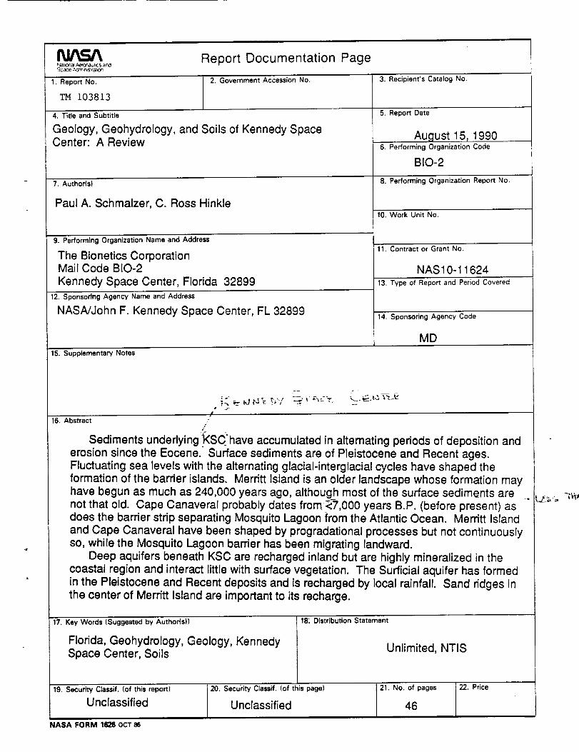
Report Documentation PageNalo_al ._=_r_lul_ s at_Scace t_'nnSlfSI,0_
1. Report No.
tO38t3
2. Government Accession No.
4. Title and Subtitle
Geology, Geohydrology, and Soils of Kennedy SpaceCenter: A Review
7. Author(s)
Paul A. Schmalzer, C. Ross Hinkle
9. Performing Organization Name and Address
The Bionetics CorporationMail Code BIO-2
Kennedy Space Center, Florida 3289912. Sponsoring Agency Name and Address
NASA/John F. Kennedy Space Center, FL 32899
3. Recipient's Catalog No.
5. Report Date
August 15, 19906. Performing Organization Code
BIO-2
8. Performing Organization Report No.
10. Work Unit No.
11. Contract or Grant No.
NAS10-1162413. Type of Report and Period Covered
14. Sponsoring Agency Code
MD
15. Supplementary Notes
= =
!
16. Abstract#
Sediments underlying;_KSChave accumulated in alternating periods of deposition anderosion since the Eocene. Surface sediments are of Pleistocene and Recent ages.Fluctuating sea levels with the alternating glacial-interglacial cycles have shaped theformation of the barrier islands. Merritt Island is an older landscape whose formation mayhave begun as much as 240,000 years ago, although most of the surface sediments arenot that old. Cape Canaveral probably dates from_,000 years B.P. (before present) asdoes the barrier strip separating Mosquito Lagoon from the Atlantic Ocean. Merritt Islandand Cape Canaveral have been shaped by progradational processes but not continuouslyso, while the Mosquito Lagoon barrier has been migrating landward.
Deep aquifers beneath KSC are recharged inland but are highly mineralized in thecoastal region and interact little with surface vegetation. The Surficiai aquifer has formedin the Pleistocene and Recent deposits and is recharged by local rainfall. Sand ridges inthe center of Merritt Island are important to its recharge.
17. Key Words (Suggested by Author(s))
Florida, Geohydrology, Geology, KennedySpace Center, Soils
18: Distribution Statement
Unlimited, NTIS
19. Security Classif, (of this report)
Unclassified
20. Security Classif. (of this page)
Unclassified
21. No. of pages
46
22. Price
NASA FORM 1826 OCT 86