Embed Size (px)
Citation preview

Muhamadsyah / ICG 2015
297
Geology and Tectonics Analysis Ciuyah Mudvolcano,Kuningan, West Java
Faizal Muhamadsyah
Faculty of Geology, Universitas Padjadjaran
Abstract
Geological structures that developed in the study area is the same phenomenon with regional structures easternregion of West Java . Structures in Java in general east-west trending . As happened in Bogor eastern zone ,which is bounded by fault trending northwest - southeast . This zone has experienced strong folding so that produceantiklinorium the east-west axis direction . In addition there is faults which caused a shift of the axis of theanticline and occurs after deposition Halang Formation . In the northern part of this zone , state geologicalstructure has the north because of pressure from the south . The essence of this multiplicity is composed of Miocenesedimentary rocks while the wings consists of Pliocene sedimentary rocks . Zone Ciniru structure , more localzoning structure is formed primarily by the fault ride , folding and faults flat minor, this structure has a patternzone briefing nearly east-west ( EW ) , extending from Bunigeulis area in the western part , restricted zonesMajalengka – Cilacap structure , until Cipedes area in the eastern part bounded by fault zones Banjarharja-Koromong . Ciuyah Mudvolcano formation , in the village Ciuyah , Kuningan regency , a large part due to theinfluence of structural zones that occur in the study area . Lithology authors on this unit is dominated by mudstoneand sandstone , as well as a small portion volcanic rocks and alluvial . Lithology are generally compiled pattern isanastomatik stream sediment , However the unit is dominated by mudstone and sandstone . This phenomenon ,thought to result from the influence of intensive tectonic cut bedrock , causing weak zones are easily inflicted by theflow of water .
Keywords : Geological structure, Ciuyah, Mudvolcano.
INTRODUCTION
Geological conditions of an area, amongothers lithology, stratigraphy, structural geologyand geomorphology. After that will be analyzedalso tectonic processes that have occurred thereinduring and after the formation of the landscapeCiuyah. These data are the basis that will be usedto identify the geological resources of a region.
From the data obtained in the review of thesurface, is: The surface morphology is acombination of areas such as swamps and muddylake. Here, mud and saltwater kept out of thebowels of the earth. And also some springs orwells made in the Ciuyah Village area alwaysremove water taste salty. Discharge water comingout on the lake is not so great though for the long
term fairly widely spread. After the waterevaporates, leaving the salt stored in the form ofcrystals.
Previous researchers in this area is very difficultto find, some writing about Ciuyah Village onlyrevealed on the population side alone. Satyana(2008,https://sites.google.com/site/lusilibraryhardi2010/awang/1-paper-2008) identify any mud-volcanoin this area. Calling as a post-eruptive phase ofmud-volcano, fluid migration through permeablezones deeper then seeps to the surface mud-volcano. Sealed track surface to change thesystem back from open to closedphysicochemical conditions. This phase followsthe eruption phase and begin preparations for the

Muhamadsyah/ICG 2015
298
next eruption. The new eruption phase can betriggered by earthquakes or tectonic.
MATERIALS AND METHODSRESEARCH
To know the condition of geological andtectonic analysis in this area used source ofregional geological maps issued by theDirectorate of Geology, landsat imagery foridentifying the tectonic conditions anddistribution of rock, as well as geologicalmapping in selected areas.
Figure 1. Location of Research in Ciuyah Village, Kuningan
Regency, West Java
RESEARCH LOCATION
Geographically the study area lies between7 ° 00 ' 0.2736 "S - 7 ° 5 ' 24.0288 " S and 108 °27 ' 33.2352 "E - 108 ° 32 ' 59.4636 " E. Thestudy area is the combination of MapBakosurtanal Kadugede sheet no. 1308-444 scale1: 25,000 edition of I - 2001 and MapBakosurtanal Lebakwangi sheet no. 1308-533scale 1: 25,000 edition of I -2000. Research areasadministratively belong to the Ciniru andsurrounding area, Kuningan regency, West JavaProvince (Figure 1).
The Ciuyah Village located in the districtCiniru, located about 2 kilometers from thelocation of the center of the government districtto the east following the road to the village ofCipedes. To reach the location of the research ittakes approximately 5 hours from Bandung.
Location of the study already have a fairly goodinfrastructure and is quite advanced as highwayswere pretty good, but for the way to the remotearea and not so good.
RESULTS AND DISCUSSION
Geology of Ciuyah area
Geomorphology of the research area isdivided into four geomorphological units.Thoseare volcanic slightly steep hills unit, structuralsediment steep high hills unit, structural sedimentslightly steep hills unit and denudation sedimentslightly hills unit.
Based on the lithostatigraphy aspect, the researcharea is divided into four units which are (from theoldest) : Claystone Unit (Tmbl), Sandstone Unit(Tmbp), Monomic Breccia Unit (Tmbx) andVolcanic Breccia Unit (Qbv),
Geological structures that develop in thethe study area are fold, joint, and fault. Fold,consist of Gunungmanik anticline, Pasiragunganticline, Pakapasan anticline, Sukasari anticline,Cijemit anticline, Margahayu anticline,Karangsari anticline, Margamukti anticline,Mungkaldatar anticline, Cimahi syncline, Citapensyncline, Pakapasan syncline, Sukasari syncline,Cijemit syncline, Cibodas syncline, Tagogsyncline and Mungkaldatar syncline. Fault, thereare Cijemit thrust fault, Citapen thrust fault,Pamupukan thrust fault, Pakapasan sinistral fault,Ciniru sinistral fault, and Cibongkot sinistralfault.
Geological history of the region beganwhen Early Miocene, research area was deep seaenvironment, submarine fan depositional systemand caused turbidite claystone unit (Tobp). WhenMiddle-Late Miocene epoch Sandstone unit(Tmbl) deposited with conformity relation atdeep sea environment, submarine fandepositional system because of regression of sealevel and at that time, increased volcanic activitythat deposited volcanic material forming brecciaunit (Tmbx). When Pliocene-Pleistocene epoch

Muhamadsyah / ICG 2015
299
there was tectonic activity that caused fold, jointand fault in the research area. And then there wasvolcanic activity which caused volcanic brecciaunit (Qbv) deposited.
The resources of the research area are geothermalpotential, mineralization and digging rawmaterials and sediment that can be found in theriver. And the disaster risk in the area islandslide.
Geological structure Ciuyah andsurrounding areas
Depression Bogor zone in the easternmostpart forming a concave configuration bend to thenorth, characterized by folding and fault to thenorth. In general, the central part of anticlinoriumformed composed of sedimentary rocks in theMiocene and their wings are composed of rockformations of Pliocene and Pliocene age thebottom. The total thickness of the Neogenesedimentary rocks in this depression is estimatedto reach a thickness of more than 6000 meters(van Bemmelen, 1949)
Figure 2. Simplification geological map of the study area,
stereonet shows the trend of rock layering.
Formations of sedimentary rocks isdominated by turbidite sediments under the seawith volcanic-clastic composition, which isquickly deposited into the depression zoneregion, such as propagation formations, Pemali
Formation, Halang Formation, and KumbangFormation.
Relative to the north of Regional Ciuyah,approximately 18.5 kilometers apart lies MountCiremai, which is one of the active volcanoes inWest Java. At the foot of Mount Ciremai the westand north, located Neogene deformation ofsedimentary rock which deforms plastically andpartly formed clay diapirisma (Pemali shales,Subang Kaliwangu shales and shales).
Regional structural elements the study area(Figure 3) consists of: 1). Cilacap Majalengka-zone structure, zoning structure is formed by athrust fault and transverse fault dominated by thenorthwest-southeast direction of the pattern (NW-SE), 2). Banjarharja koromong structure-zone,zoning structure is formed mainly by thrust faultand a small portion of transverse fault dominatedby the northwest-southeast direction of thepattern (NW-SE), and 3). Zone structure Ciniru,zoning structure more local is formed mainly bythrust fault, folding and transverse fault minor,zone of this structure has a pattern of directingnearly east-west (EW), extending from theregions Bunigeulis in the west, is restricted zonesMajalengka structure-Cilacap, up Cipedes area inthe eastern part bounded by fault zonesKoromong-Banjarharja
Structure Elements
Based on the interpretation of thealignment pattern of topographic map scale of 1:50,000, map the flow pattern of the river and amap of digital elevation models, obtained severalgeological lineament direction. Roset 20diagram with the class interval showed that thepattern of geological lineaments in the study areaare classified into three patterns, respectively themost significant of which are: A). the west-eastnorth-east south-west (WSW-ENE), then B).direction northwest-southeast (NW-SE) and C).minor nature trending northeast-southwest (NE-SW).

Muhamadsyah/ICG 2015
300
The first trend virtually east-west trendingrelated to the linearity of the ridge pattern formedby the ridge of folding sedimentary rocks andthrust fault, the direction is more indicative ofpatterns and moves toward the transpositiondirection caused by faults that are lateral. Trendof the axial zone of the anticline and syncline andthrust fault represented by the alignmentdirection nearly east-west (Figure 2).
Trend straightness both trendingnorthwest-southeast (NW-SE) relating to thepartial thrust fault linearity rise, the patternmoves towards layering of rocks and hypotheticalfault possibility that the criteria in the field is notobserved. At the location of the complexmountain of mud Ciuyah, the distribution ofclusters of holes release fluid or system ventingthe intrusion of mud partly shows the linearity ofthe distribution in the direction northwest-southeast, as well as the orientation of the longaxis of the perimeter of the distribution of theoverflow and mud inundation on the surfaceindicate the orientation of the long axis in apattern direction northwest-southeast.
Figure 3. Map straightness topography and drainage patterns
that show two main trends and the trend minor straightness
In addition to the map lineamentinterpretation shown that there is a trendnorthwest-southeast trending lineament properlocations across the Ciuyah mud-vulcanointrusion complex.
Based on field data and the results of previousinvestigators research paper, the bedrock in theCiuyah area is form over Pemali Formation andHalang Formation, tectonically has undergonefolding and faulting. The elements that make upthe structure of tectonic Ciuyah configurationconsists of one major thrust fault which wasinterrupted by lateral slip conjugate (tear fault).Folds echelon undergo transposition formed in atleast three lanes or folding arc that stretches tothe trend between the east-west (EW), andnorthwest-southeast (NW-SE). This patternfollows the trend of more regional than CiniruStructural Zone.
On the reconstruction of geologicalstructures illustrated in cross section of geology,bedrock composed of facies mudstone andsandstone facies Halang Formation andFormation Possible Pemali older form a creaseantiklinan or antiform. Orientation axial zoneformation anticlinal structure is oriented east-west (EW). Thrust fault break the axial zone ofthe central part of this antiform, and contributedisclose Halang Formation claystone facies andFormation Pemali, some drag folds, transpositiondirection of layering of rock, fault rock and zonesof fault breccia.
Based on the observation of the pattern ofdip or layering tilt Regions Ciuyah sloping to thesouth, as well as some indication of kinematicobtained from the drag fold, thrust fault andfolding to form structural configuration in Ciuyahhave transport tectonic (vergence) to the north.
In addition to the main thrust fault, supposedlythere are faults that are dip-slip, which is locatedin the north of the main thrust fault (Figure 3).This hypothetical fault is suspected to be sluranfor groundwater circulation and opening regionalbaffle structure (regional seal) that is formed bythe Halang Formation claystone facies andPemali Formation.
Trend axial zone of folding and the strikeof the thrust fault Ciuyah indicates the rangedirection north-south compressional regime (NS)

Muhamadsyah / ICG 2015
301
to northeast-southwest (NE-SW) responsible forthe formation of structural elements in the centralpart of Zone Structure Ciniru. This compressionalregime also involves the bedrock formationsPemali and Halang Formation and andesitic dikesform of sills and dikes which has experiencedfaulting and at several locations involved ascomponents in fault breccias.
Interpreted to mean that migrationchannels and the possibility of fluid circulation iscontrolled by faults that developed in the studyarea. Thrust fault, the horizontal fault, foldingand diapirisma are all factors that favor therelease or migration of the fluid to the surfaceand provide an outlet for the material and fluidunder conditions of excessive pressure, thematerial clay that make up the rock formationsbase undergo a process elusiasi and eventuallyform of mud-vulcano on the surface intrusion.
Figure 4. Model illustrative regional tectonic and sharpnessare simple shear working in the area of research, derivedfrom regional structural elements.
Internal typology
Although there are some differences withregard to the external manifestations of themorphology and structure of the intrusion mud-vulcano in a smaller scale, the formation ofintrusion mud-vulcano in Ciuyah can be groupedinto three types of four types exist according toclassification model surface morphology of mud-vulcano in Depression Transylvania (Yates,2010), namely: 1). type of mud pool, 2). dometype / shield (dome ramps), and 3). Type caldera.This group includes all the holes that show thepattern of intrusion mud-vulcano flats and thetypes of character short lifespan activity. Mudpool shows the morphology and properties suchas a puddle or pool of water filled with bubblesof gas emissions (gas bubble), and looks like aswamp (Marshy).
Figure 5. Mud cone which is the only recent activity whichis higher than the proportion of solids in the fluid mud
extrusion complex location, debitnya estimated <1 m3 / day
Materials out meet pools are more dilute,in certain cases which demonstrate the activity ofintense, dense and thick, in which more activitiesare weak or in a non-active phase (dormant).Depending on the level of activity, the materialthat comes out in a puddle of mud pool there iscovered by a dense material encrusted andvegetation. On the outskirts of the hole coveredby a dense material, signs of activity shown by

Muhamadsyah/ICG 2015
302
the rumble if trodden under foot, and if the crustof mud that covered it revealed, new gas bubblesin the water can be seen (bubble).
Mud coneCategory mud cone in touch with all the
holes mud-vulcano that has a positive formationsresulting from the intrusion of mud hole througha narrow slit and deposited on a surface that hasbeen formed previously. Overlap the flow of mudto the surface is repeated continuouslyaccumulate and make mud-vulcano sloping coneresembles the shape of a shield volcano.Because almost all studies on mud-vulcanointrusion indicate that the material is spewed intothe surface of the liquid, dilute with lowviscosity, the mountains it generates a coneshowing soaring ramps and only a few tens ofcentimeters above the surface of its sub.
Figure 6. The location that shows of a bubbling fluid(bubbling) indicates pressurized gas emitted to the surface,
the fluid temperature 37 C
The local angle of inclination or slope ofthe topography of origin will determine the shapeand symmetry properties of the mud mound. Incases where mud flows on a flat surface, theshape of the mountains mud will be completelyconical, while on the surface of the slopingtopography, the mud volcano will have rampsasymmetric cone pattern and has side elongatestoward the slope of the topography of origin.
Mud domeNaming the dome of mud (mud dome)
initially be used to describe the surfacemanifestation of diapirisma submarine volcano,without material spewed into the ocean floor. Inthis study, the name used for the mud domedome-shaped of mud-vulcano without a vent andfluid accumulation in the surface of the mud andclear.Although the mud dome type that typically arenot found in the Ciuyah mud-vulcano complex,but the point of eruption one of mud-volcanowhich showed sloping dome without any realactivity on the surface.The shape of the dome is differentrom the typemud cones. Mud dome structure shows the formsindividually and showed that under the surfacethere is a widening structure, likely due toaccumulation of fluid and pressure, which canwiden the feeder channel.
Mud calderaThe term of mud caldera used for the mud-
vulcano that have depression as a result ofinfrastructure rubble mud-vulcano. Such groupslike mountains mud-vulcano caldera.Depend on the characteristics of the materialspewed out, the moisture content and the weatherconditions, the formation of the caldera can becovered by a semi-solid material, or vegetation.Feeder channel the mud caldera internal structurehas a shape that widens and forms a funnel.
Figure 7. Location of the Ciuyah mud-vulcano complexsshowing typology mud pool.

Muhamadsyah / ICG 2015
303
Figure 8. Activity gurgle of fluid (bubbling) which isoriented NW-SE elongated almost show conduit is slit
(fissure)
Figure 9. Typology flat point of discharge hole showed onlyintermittent water seepage to the surface, and the surface is
covered in part which has been solid and vegetation
Figure 10. Typology Mud pool that shows funel wideningand conduit are relatively larger than the hole in the
surrounding
ConclusionsThe phenomenon of eruption of mud from
beneath the surface, known as mudflow, whichhis form to a surface known as the mud-vulcano
is a geological phenomenon that is common indepression-lane east-west cross almost from thestart Zones Bogor, Kendeng Zone to the east inthe offshore basin Bali- Lombok. Thephenomenon occurs in an environment that has ageological setting broadly similar. Mud-vulcanoin general, thrive in an environment ofconvergence plate boundaries, that experiencedlateral and vertical pressure is very large.From the survey data worldwide (Yusifov, 2004),the incidence of more mud-vulcano occurred inthe sea (offshore) than on land (onshore)The study widely in the territory of Azerbaijan,which found most onshore mud-vulcano in theregion than anywhere else in the world show aclose relationship between mud volcanism withdiapirisma. It is unknown whether the mudflowin the region Ciuyah associated with the processdiapirisma, because it is not the inclusion of thedata further and intensified in this study, thanthose observed in the surface that shows fossilssheared clay, distortion and chaotic beds andshale deformation in several locations outcrops.Source mud and fluid in this study can not bedetermined as a definite, because it requiredfurther analysis involving mineralogical andhydrochemical clay minerals. The depth of whichis the source or origin of mudstone which thenundergoes elusiasi still in question, apart from thedata obtained palaeontologi surface, whichindicates that the age of the exposed bedrock ismuch younger than the age of paleontologyobtained
AcknowledgementsThe authors would like to thank The 2nd
International Conference of the Faculty ofGeology and The 1st Joint Conference, Facultyof Geology, University of Padjadjaran, WestJava, Indonesia - Faculty Of Science And NaturalResources Universiti Malaysia Sabah, who hasbeen willing to cooperate. Thanks are also due tocolleagues Geology-UNPAD that have helped theformation of this article.
Muhamadsyah/ICG 2015
304
References
Anonim. 1992. Himpunan Peraturan LingkunganHidup dan Kependudukan. CV. Eko Jaya. Jakarta.Indonesia.
Anonim. 2010. Regional Setting: Diapirs and MudVolcanoes of Java, (online),(https://sites.google.com/site/lusilibraryhardi2010/indonesia-case/jawa-island, diakses 19 Juli 2011).
Akesson, Maria.2008. Mud volcanoes – a review. ThesisBachelor, Department of Geology Lund University,(unpubl.).
Andrea, Gal. 2010. Mud Volcanoes from the Eastern andCentral Part of the Transylvanian Depression. Thesis Phd,Babes – Bolyai University, Faculty of Geography. Cluj-Napoca, (unpubl.).
Aribowo. Bambang. 1990. Geologi Daerah Bunigeulis danSekitarnya Kecamatan Ciniru, Kabupaten Kuningan, JawaBarat. Skripsi Pemetaan Geologi Lanjut. FakultasMatematika dan Ilmu Pengetahuan Alam. Bandung,(unpubl.).
Bachtiar, T. 2005. Asam di Gunung, Garam di Gunung,Bertemu di Ciniru juga!, (online),(http://groups.yahoo.com/group/Baraya_Sunda/message/4030, diakses 19 Juli 2011).
Budhitrisna, T. 1990. Edisi II, Peta Geologi LembarTasikmalaya, Jawa Barat, Skala 1:100.000. PusatPengembangan dan Pengembangan Geologi. Bandung.
Dimitrov, Lyobomir I. 2002. Mud volcanoes—the mostimportant pathway for degassing deeply buried sediments.Earth-Science Reviews 59 (2002) 49-76.
Harun, Satyana Awang. dan Asnidar.2008. Mud Diapirs andVolcanoes in depressions of Java to Madura: Orogins,Nature, and Implications to Petroleum System. ProceedingsIndonesian Petroleum Association (IPA), 32nd AnnualConvention & Exhibition., IPA08-G-139.
Hensen, Christian., Nuzzo, Marianne., Hornibrook, Edward.,Pinhiero, Luis M., Bock., Barbara., Magalhaes, Viktor H.dan Bruckmann, Warner. 2006. Sources of mud volcanofluids in the Gulf of Cadiz – indications for hydrothermalimprint. Geochimica et Cosmochimica Acta 71 (2007)1232–1248.
Kastowo. 1975. Peta Geologi Lembar Majenang, Jawa,Skala 1:100.000. Pusat Pengembangan Geologi. Bandung.
Madielda, T., Somoza, L., Pinhiero, L.M., Fernandez-Puga,M.C., Vazquez, J.T., Leon, R., Ivanov, M.K., Magalhaes,V., Diaz-del-Rio, V. dan Vegas, R., 2008. Tectonics and
Mud Volcano Development in the Gulf of Cadiz. MarineGeology (2008).
Martinelli, Giovanni. dan Panahi, Behrouz (editor). 2003.Mud Volcanoes, Geodynamics and Seismicity. NATOScience Series, Earth and Environmental Sciences – Vol. 51.
Mazzini, A., Svensen, H., Akhmanov, G.G, Aloisi, G.,Planke, S., Malthe-Sørenssen, A. dan Istadi, B. 2007.Triggering and dynamic evolution of the LUSI mudvolcano, Indonesia. Earth and Planetary Science Letters 261(2007) 375–388.
Pierre, Fransesco Dela., Festa, Andrea. dan Irace,Andrea.2007. Interaction of tectonic, sedimentary, anddiapiric processes in the origin of chaotic sediments: Anexample from the Messinian of Torino Hill (TertiaryPiedmont Basin, northwestern Italy). Geological Society ofAmerica Bulletin v. 119, p. 1107-1119.
Rifai, Rahman. 2008. Spatial Modelling and Risk Assesmentof Sidoarjo Mud Volcanic Flow. Thesis M.sc, Gadjah MadaUniversity (Yogyakarta, Indonesia) and InternationalInstitute for Geo-information Science and Earth Observation(Enschede, The Netherlands, (unpubl.)
Sugiarto, Agus. 2004. Geologi Daerah Cipedes danSekitarnya Kecamatan Ciniru, Kabupaten Kuningan,Provinsi Jawa Barat. Skripsi Pemetaan Geologi Lanjut.Fakultas Matematika dan Ilmu Pengetahuan Alam.Jatinangor, (unpubl.).
Vanessa, Agata., 2011. Geologi Daerah Ciniru danSekiarnya Kecamatan Ciniru, Kabupaten Kuningan,Provinsi Jawa Barat. Skripsi Pemetaan Geologi Lanjut.Fakultas Teknik Geologi, Universitas Padjadjaran.Jatinangor, (unpubl.).
Yusifov, Mehdi. 2004. Seismic Interpretation andClassification of Mud Volcanoes of The South CaspianBasin, Offshore Azerbaijan. Thesis M.sc, Texas A&MUniversity, (unpubl.).
Zeinalov, Gasham A. 2000. Importance of Remote-SensingData in Structural Geologic Analysis of Oil- and Gas-Bearing Regions of Azerbaijan. Natural ResourcesResearch, Vol. 9, No. 4.
Ildrem Syafrie/ICG 2015
305
Geochemistry study of Granitoid Basement Rock in Jambi Sub Basin,South Sumatera, Indonesia
Based on JSB-3, JSB-4 and JSB-6 wells data
Ildrem Syafrie1, Euis Tintin Yuningsih1 and Hiroharu Matsueda2
1Faculty of Geology, Padjadjaran University, Jl. Raya Bandung-Sumedang Km. 21, Jatinangor, 45363, Indonesia2 The Hokkaido University Museum, Hokkaido University, Sapporo, Japan
Email: Email: [email protected]
Abstract
Research area is located in Jambi sub basin, the northern part of South Sumatera Basin formed during Tertiary age.South Sumatera Basin, as well as the Central Sumatera and North Sumatera Basins is a basin form in the back arc belt.The propose of the research is to determine petrological characteristics of the pre-Tertiary basement rock based onmajor oxides analysis from the granitoid basement rock in research area with AAS method (Atomic AbsorptionSpectrophotometry). Thus the petrogenesis could be determined, including kinds and characteristics of parent magma.Chemical rock analysis confirm the lithology of granitoid basement in Jambi sub basin is intermediate – acid magmas,calc-alkaline, medium – high K, metalluminous, subduction-related (orogen) at active continental margin. Granitoidbasement rock of JSB-4 and JSB-6 shows magnetite series and I type. This Mesozoic granitoid probably as extensionfrom the Thailand and Burma granite province, which underline the fact that there has been a history of subduction-related magmatism along southwestern edge of Sundaland since earliest Mesozoic times.
Keywords : granitoid, calc-alkaline, metalluminous, orogen, magnetite series, I-type
Introduction
Jambi Sub Basin is located at the north part ofSouth Sumatra Basin that formed during theTertiary age. In the north, Jambi Sub Basin islimited by Tigapuluh Mountains, to the west by theBukit Barisan Mountains, to the south by thebasement high partly exposed to the surface in theform of Duabelas Mountains, and in the east by thehighs that most of basement rocks exposed to thesurface in the form of Belitung, Bangka, Singkepand Lingga Islands (Figure 1). South Sumatra Basin,as well as the Central Sumatra Basin and the NorthSumatra Basin, is formed at back arc belt during theTertiary.
According To Pulunggono and Cameron(1984), the pre-Tertiary tectonic framework ofSumatra in the form of continent and oceanmicroplates mosaic accreted in Late Triassic whenmicroplate Mergui, Malacca and East Malaya united
to form Sundaland. The accretion, further involvingthe west coast of Woyla Terrain in the LateMesozoic. Magmatism and faulting were intense inthis Sundaland.
According to McCourt et al. (1996), the resultsof the K / Ar analysis of the Barisan Mountains ofsouthern Sumatra indicates the existence of fourmain plutonic activity periods such as Miocene-Pliocene (20-5 million years ago), Early Eocene(60-50 million years ago), Middle-Late Cretaceous(117-80 million years ago) and Jurassic-EarlyCretaceous (203-130 million years ago). Plutonic inthe western part of Sumatra also indicate the periodactivity-plutonic in Perm (287-256 million yearsago). In addition there is an indication that the EarlyMesozoic activity has started since the Late Triassic,thus there are two magmatic cycle, namely:
1) Late Triassic to Early Jurassic (220-190 millionyears ago)

Ildrem Syafrie/ICG 2015
306
2) Middle Jurassic to Early Cretaceous (170-130million years ago)
Figure 1. Research area location map(Source ; Pujasmadi et al., 2002)
Pre-Tertiary complex data compiled with dataobtained from the Directorate of Geology anddrilling activity of company oil, a certain pattern ofgranitoid distribution can be observed. Radiometricage determination of some rock samples from therocks intrusion showed that the north-southdistribution of granitoid rocks are from older toyounger one, each of which is aligned with thepattern and direction of east - west to the northwest -southeast.
According to De Coster (1974), pre-TertiaryComplex or basement in the Central Sumatra andSouth Sumatra Basins consists of Mesozoic igneousand metamorphic rocks, and Palaeozoic andMesozoic carbonates. Palaeozoic and Mesozoicsedimentary and metamorphic rocks are intensivelyfolded and faulted, and intruded by during Mid-Mesozoic orogenesis. The complexity of thestructural relations of older rocks can be seen inoutcrop in the South Sumatra Basin.
According Pujasmadi et al. (2002), thebasement rocks in the study area consists of shallowintrusive to extrusion volcanic rock, which isassociated with volcaniclastic-sedimentary rocks,plutonic rocks and coarse-grained crystallinemetasedimentary rock. Volcanic rock compositionconsists of andesite, rhyolite and dacite. Thecomposition of the plutonic rocks are mainly graniteand gabbro-dolerite. Metasedimentary rockcomposed of quartzite, limestone and marbleargilit's.
The purpose of this study was to determine thepetrological characteristics of pre-Tertiary basementrocks in detail based on the analysis of geochemicalanalysis on major oxides composition that form thebasement granitoid rocks in the study area.
Methodology
Chemical analysis is mainly done by using the AASmethod (Atomic Absorption Spectrophotometry),which is one of the method to determine thechemical composition of a rock based on theradiation of electromagnetic absorption. For thepurposes of this rock chemical analysis, there arefive rock samples analyzed consisting of twosamples from JSB-3 well, one sample from JSB-4well and two samples from JSB-6 well. Analysis ofrock chemistry's done by analyzing the compositionof the major elements to determine the chemicalcharacteristics that could ultimately be used todetermine petrogenesis of rocks in the study areathat includes the type and characteristics of themagma origin.
The weight percentage of each major oxides forevery rock specimens can be seen in Table 1.
The limitations of rock samples analyzed greatlyaffect the interpretation of the evolution of thevolcanic and plutonic rock in the research area. Themore rock samples were analyzed, the higher levelof accuracy in interpretation. The limitations of rocksamples analyzes due to the relatively rare freshrock samples in all three wells.

Ildrem Syafrie/ICG 2015
307
Table 1. Major oxides composition of the basement granitoidrocks in research areas based on data from the JSB-3, JSB-4 and
JSB-6 wells
Results
Based on the results of the chemical analysis of rocksamples from JSB-3 well at 1987.50m and1994.38m depth can be seen that the composition ofigneous rocks in JSB-3 well is andesite – basalticandesite, it is reflected in the TAS diagram forvolcanic rocks of Wilson, 1989 and K2O - SiO2
diagram from Withford and Nichols, 1973 (Figure2). While based on the K2O content, both of rocksamples were analyzed from the JSB-3 wellincluded in the moderate-potassium series (medium-K) and are included in the calc-alkaline rocks series.This is also reflected in the K2O - SiO2 diagramfrom Le Maitre, 1989; Rick-wood, 1989; Peccerilloand Taylor, 1976 (Figure 3). According to Shand(1947) the rock in JSB-3 well is metalluminousalumina saturation (Figure 4).
Rock sample were used for chemical analysis in theJSB-4 well is located at 2654.02m depth. Based onthe results of chemical analysis showed that theigneous rock in JSB-4 well is granite. This isreflected in the TAS diagram for plutonic rocks of
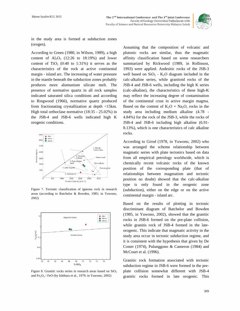
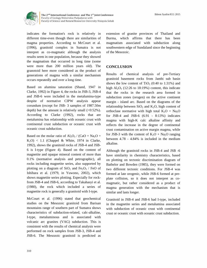
Wilson, 1989 (Figure 5) and An-Ab-Or diagram ofBarker, 1979 (Figure 6). Based on the K2O contentof the analyzed rock sample from JSB-4 wellincluded in the high potassium series (high-K) andcalc-alkaline rocks series. This is reflected in thediagram of K2O - SiO2 from Le Maitre, 1989;Rickwood, 1989; Withford and Nichols, 1973(Figures 2 and 3). Based on the tectonicclassification of Batchelor and Borden (1985) rocksample from the JSB-4 well formed in late orogenic(Figure 7). This granitic rocks series include inmagnetite series (Ishihara et al., 1979; Figure 8)with metalluminous alumina saturation (Shand,1947; Figure 4) and according to Chappel & White,(1974) included in the I-type (Figure 4).
Figure 2. Classification of granitoid basement rocks based onvariations of SiO2 and K2O contents (according to Whitford &Nichols, 1973)
Figure 3. Classification of granitoid rocks based on the contentof SiO2 and K2O.( (Rickwood, 1989); Italic dot lines (Le Maitreet al., 1989); Shaded areas: boundary area by Peccerillo andTaylor (1976), Ewart (1982), Innocenti et al. (1982), Carr(1985) and Middlemost (1985) summarized by Rickwood(1989) (in Rollinson, 1993)

Ildrem Syafrie/ICG 2015
308
Chemical analysis for lithology from the JSB-6 wellwere taken at 2341.78m and 2343.77m depth. Basedon the results of chemical analysis showed that theigneous rocks compose at JSB-6 well isgranodiorite, as a plotting result in the TAS diagramfor plutonic rocks of Wilson, 1989 (Figure 5) andAn-Ab-Or diagram of Barker, 1979 (Figure 6).Based on K2O content of both rock samples fromthe JSB-6 well included in the series of highpotassium (high-K) and are included in the calc-alkaline rocks series. This is reflected also in theK2O - SiO2 diagram from Le Maitre, 1989;Rickwood, 1989; Withford and Nichols, 1973(Figures 2 and 3). Based on the tectonicclassification of Batchelor and Borden, 1985 rockfrom the JSB-6 well formed at the pre-platecollision (Figure 7). According to Ishihara et al.1979 included in the magnetite series (Figure 8)with metalluminous alumina saturation (Shand,1947; Figure 8) and by Chappel & White, 1974included in the I-type (Figure 4).
Chemical analysis results (Table 1) shows that thevalue of LOI is between 0:39 - 0.85%, it indicatesthat the alteration product/weathering in the samplesis relatively weak, making it possible forinterpretation of petrogenesis. SiO2 content rangedbetween 53.70 - 71.08% was shown intermediate –acid composition.
Figure 4. Classification of alumina saturation (Shand, 1947) andthe type of rocks (Chappel & White, 1974) in Clarke (1992)
Figure 5. Classification of granitoid basement rocks based ontotal alkaline vs silica/TAS (Cox et al., 1979 adapted by Wilson,1989 ; in Rollinson, 1993)
Figure 6. Classification of granitic rocks based on normativemolecular composition of An-Ab-Or (according to O'Connor,1965 in Rollinson, 1993)
Among the main elements, some that are considered"stable" and are often used for interpretation ofpetrogenesis are K, Ti, Mn, P and Mg. Among thosefive main elements, Ti is considered the most stableso have a high reputation for interpretation.According to Gill (1981, in Yuwono, 2002), therocks were formed in a subduction zone (orogen)has a value of TiO2 is <1.3%. The results ofchemical analysis of all samples showed the contentof TiO2 is 0:40 to 1:31%, this indicate that the rocks
Ildrem Syafrie/ICG 2015
309
in the study area is formed at subduction zones(orogen).
According to Green (1980, in Wilson, 1989), a highcontent of Al2O3 (12:26 to 18:19%) and lowercontent of TiO2 (0:40 to 1:31%) it serves as thecharacteristics of the rock at active continentalmargin - island arc. The increasing of water pressurein the mantle beneath the subduction zones probablyproduces more alumunium silicate melt. Thepresence of normative quartz in all rock samplesindicated saturated silica conditions and accordingto Ringwood (1966), normative quartz producedfrom fractionating crystallization at depth <15km.High total orthoclase normative (18:35 - 25.02%) inthe JSB-4 and JSB-6 wells indicated high Korogenic conditions.
Figure 7. Tectonic classification of igneous rock in researchareas (according to Batchelor & Bowden, 1985; in Yuwono,2002)
Figure 8. Granitic rocks series in research areas based on SiO2
and Fe2O3 / FeO (by Ishihara et al., 1979; in Yuwono, 2002)
Assuming that the composition of volcanic andplutonic rocks are similar, thus the magmaticaffinity classification based on some researcherssummarized by Rickwood (1989, in Rollinson,1993) were applied. Andesitic rocks of the JSB-3well based on SiO2 - K2O diagram included in thecalc-alkaline series, while granitoid rocks of theJSB-4 and JSB-6 wells, including the high K series(calc-alkaline), the characteristics of these high-Kmay reflect the increasing degree of contaminationof the continental crust in active margin magma.Based on the content of K2O + Na2O, rocks in thestudy area including medium alkaline (4.78 -4.84%) for the rock of the JSB-3, while the rocks ofJSB-4 and JSB-6 including high alkaline (6.91-8.13%), which is one characteristics of calc alkalinerocks.
According to Girod (1978, in Yuwono, 2002) whowas arranged the scheme relationship betweenmagmatic series with plate tectonics based on datafrom all empirical petrology worldwide, which ischemically recent volcanic rocks of the knownposition of the corresponding plate (that ofrelationships between magmatism and tectonicposition no doubt) showed that the calc-alkalinetype is only found in the orogenic zone(subduction), either on the edge or on the activecontinental margin - island arc.
Based on the results of plotting in tectonicdiscriminant diagram of Batchelor and Bowden(1985, in Yuwono, 2002), showed that the graniticrocks in JSB-6 formed on the pre-plate collision,while granitis rock of JSB-4 formed in the late-orogenic. This indicate that magmatic activity in thestudy area occur in tectonic subduction regime, andit is consistent with the hypothesis that given by DeCoster (1974), Pulunggono & Cameron (1984) andMcCourt et al. (1996).
Granitic rock formation associated with tectonicsubduction regime in JSB-6 were formed in the pre-plate collision somewhat different with JSB-4granitic rocks formed in late orogenic. This
Ildrem Syafrie/ICG 2015
310
indicates the formation's rock is relatively indifferent time-even though there are similarities ofmagma properties. According to McCourt et al.(1996), granitoid complex in Sumatra is notinterpret as co-magmatic although the analysisresults seem in one population, because they showedthe magmatism that occurred in long time (somewere more than 200 million years old). Thegranotoid here more considered as the product ofgenerations of magma with a similar mechanismoccurs repeatedly and over a long time.
Based on alumina saturation (Shand, 1947 inClarke, 1992) in Figure 4, the rocks in JSB-3, JSB-4and JSB-6 were included in the metalumina-typedespite of normative CIPW analysis appearcorundum (except for JSB- 3 samples of 1987.50mdepth) but the amount is relatively small (<0:52%).According to Clarke (1992), rocks that aremetalumina has relationship with oceanic crust withcontinental crust subduction or oceanic crust withoceanic crust subduction.
Based on the molar ratio of Al2O3 / (CaO + Na2O +K2O) < 1.1 (Chappel & White, 1974 in Clarke,1992), shows the granitoid rocks of JSB-4 and JSB-6 is I-type (Figure 4). Based on the content ofmagnetite and opaque mineral content of more than0.1% (normative analysis and petrographic), allrocks including magnetite series, also supported byplotting on a diagram of SiO2 and Fe2O3 / FeO ofIshihara et al. (1979, in Yuwono, 2002), whichshows magnetite series plotting. Especially for rock-from JSB-4 and JSB-6, according to Takahasyi et al.(1980), the rock which included a series ofmagnetite rock is generally a granitoid with I-type.
McCourt et al. (1996) stated that geochemicalstudies on the Mesozoic granitoid from Barisanmountains range of southern part of Sumatra showscharacteristics of subduction-related, calc-alkaline,I-type, metaluminous and is associated withvolcanic arc granites (VAG) subduction. This isconsistent with the results of chemical analysis wereperformed on rock samples from JSB-3, JSB-4 andJSB-6. The Mesozoic granitoid is predicted as
extension of granite provinces of Thailand andBurma, which affirms that there has beenmagmatism associated with subduction alongsouthwestern edge of Sundaland since the beginningof the Mesozoic.
CONCLUSION
Results of chemical analysis of pre-Tertiarygranitoid basement rocks from Jambi sub basinshows the low content of TiO2 (0:40 to 1:31%) andhigh Al2O3 (12:26 to 18:19%) content, this indicatethat the rocks in the research area formed insubduction zones (orogen) on the active continentmargin - island arc. Based on the diagrams of therelationship between SiO2 and K2O, high content oforthoclase normative with high total K2O + Na2Ofor JSB-4 and JSB-6 (6.91 - 8:13%) indicatesmagma with high-K calc alkaline affinity andreflects the increase in the degree of continentalcrust contamination on active margin magma, whilefor JSB-3 with the content of K2O + Na2O rangingbetween 4.78 - 4.84% is included in the mediumalkaline.
Although the granitoid rocks in JSB-4 and JSB -6have similarity in chemistry characteristics, basedon plotting on tectonic discrimination diagram ofBathelor and Bowden (1985), they were formed ontwo different tectonic conditions. For JSB-4 wasformed at late orogenic, while JSB-6 formed at pre-plate collision, so it does not interpret as co-magmatic, but rather considered as a product ofmagma generation with the mechanism that issimilar and lasts longer.
Granitoid in JSB-4 and JSB-6 had I-type, includedin the magnetite series and metalumina associatedwith subduction of oceanic crust with continentalcrust or oceanic crust with oceanic crust subduction.
Ildrem Syafrie/ICG 2015
311
References
Bishop, M.G., 2000, South Sumatra Basin Province, Indonesia :The Lahat/Talang Akar Cenozoic Total Petroleum System,U. S. Department of the Interior, U. S. Geological Survey.
Cameron, N.R & Pulunggono, A., 1984, Sumatran Microplates,Their Characteristics and Their Role in the Evolution ofthe Central and South Sumatra Basin, Proc 13th Ann. Conv.IPA, Jakarta, May, p121-143.
Clarke, D.B., 1992, Granitoid Rocks, Chapman & Hall, 1st
Edition, London-Glasglow-New York-Tokyo-Melbourne-Madras, 283p.
De Coster, G.L., 1974, The Geology of the Central and SouthSumatra Basin, Proc 3th Ann. Conv. IPA, Jakarta, Juni,p77-110 .
Gillespie, M.R & Styles, M.T, 1999, Classification of IgneousRocks, British Geological Survey, UK, Vol.1, 52p.
Hamilton, W., 1979, Tectonics of the Indonesian Region, USGSProfessional Paper, 1map, Washington1078, 345p.
McCourt, W.J., Crow, M.J., Cobbing, E.J., Amin, T.C., 1996,Mesozoic and Cenozoic Pluton Evolution of SE Asia :Evidence from Sumatra, Indonesia, in Hall, R., & Blundell,D. J. (eds), Tectonic Evolution of SE Asia, GeologicalSociety Special Publication, no. 106, p321-335.
Pujasmadi, B., Alley, H., Shofiyuddin, 2002, Suban Gas Field,South Sumatra, Example of a Fractured BasementReservoir, IAGI Giant Fields and New ExplorationConcepts Seminar, 17 Oktober, 13p.
Pulunggono, A & Cameron, N.R., 1984, Sumatran Microplates,Their Characteristics And Their Role In The Evolution ofthe Central And South Sumatra Basins, Proc. 13th Ann.Conv. IPA, Jakarta, May, p121-143.
Rollinson, H.R., 1993, Using Geochemical Data : Evaluation,Presentation, Interpretation, Longman SingaporePublishers (Pte) Ltd, 352p.
Subandrio, A.S. & Suparka, M.E., 1994, Petrology andGeochemistry of Sibolga A-Type Granitoid, NorthSumatra – Indonesia, PIT IAGI 23rd, December, p334-354.
Wilson, M., 1989, Igneous Petrogenesis : A Global TectonicApproach, Allen & Unwin Ltd, New Zealand, 466p.
Yuwono, Y.S., 2004, Diktat Pengantar Petrogenesis,Laboratorium Petrologi dan Geologi Ekonomi DepartemenTeknik Geologi, FIKTM, ITB, Bandung, 109p.