Embed Size (px)
Citation preview
1
Geology and Soils
in
Timor-Leste
S.J. Thompson, Dili, Timor-Leste
December 16th
2011
2
Introduction.
This short report follows on from a request from the ‘Seeds of Life’ program to research the
connection, if any, in Timor-Leste between the geology of the island and the currently
known distribution of soil types.
Basic information on Timorese soils is contained in the ‘Carta Dos Solos de Timor’ published
by the ‘Junta de Investigações Cientificas do Ultramar’ in or around 1961. These maps were
subsequently digitized and the information therein re-interpreted and upgraded in 2004 to
reflect modern soil classifications, principally that of the United States Department of
Agriculture (USDA) Soil Classification for 1990.
The data was then published by the Ministério de Agricultura, Florestas e Pescas (MAP) as
their ‘Memōrias do Centro de Pesquisa e Extensão No.2’ in 2004. The digital data is
maintained by the ALGIS division of the Ministry whose assistance is noted here for the
provision of soil maps used in this report.
The geology of Timor-Leste has been a major focus of the research into the geology of SE
Asia carried out by the SE Asia Research Group at University College, London, the group
headed by Professor Audley-Charles since the mid 1960’s. His maps remain the main source
of geological information relating to the island of Timor. Another member of that research
team, Mr. Tim Charlton, undertook significant field, stratigraphic and tectonic studies on
Timor through the 1990’s and his publications also provide a comprehensive data set on
Timorese geology.
These data sets were used as the starting point for a hydrogeological study of Timor-Leste
undertaken by Geoscience Australia for the government of Timor-Leste. Geological maps
and interpretations sourced from that report and geological database have been used as the
main source of geological data within this report. Geological maps presented here are those
presented in the recently completed Geoscience Australia report. In this light the assistance
and support of Mr. Lindsay Furness, Water Resources Advisor to that project, is greatfully
acknowledged and his permission to reproduce this material is noted with thanks.
3
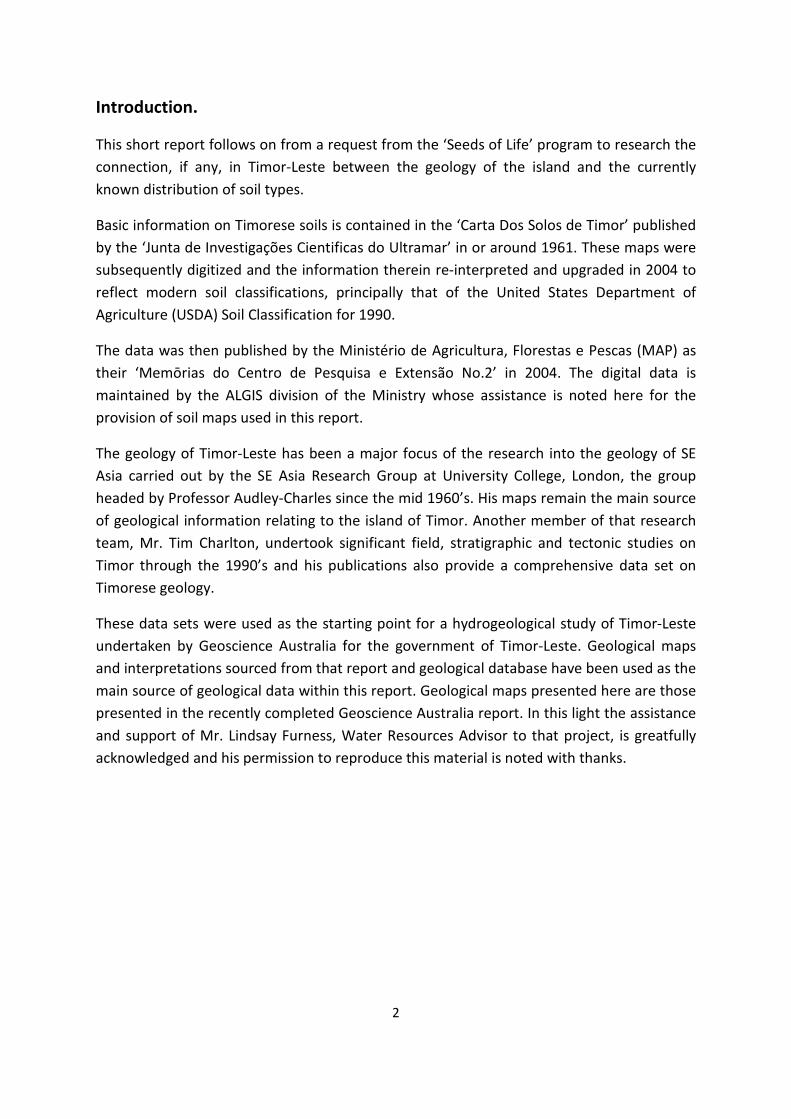
Timor-Leste, Geology.
The island of Timor sits at the eastern end of and just south of the archipelago of volcanic
islands, the Banda Arc, running eastwards from the Indonesian island of Bali. This volcanic
arc is the surface expression of lithospheric subduction currently taking place as the
Australian crustal plate moves north eastwards towards and underneath the Eurasian plate.
However, for the last 5 million years or so that subduction has become ‘locked’ in the Timor
region thereby causing the island of Timor to be thrust upwards as the only relief
mechanism available as the two crustal plates continue to converge. In layman’s language,
Timor is going up like a ‘Geological Cork’ at the extreme north eastern edge of continental
Australia.
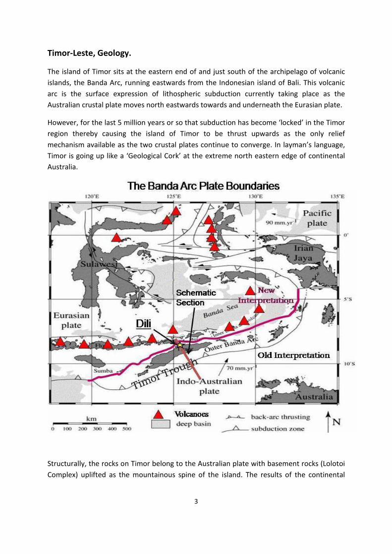
Structurally, the rocks on Timor belong to the Australian plate with basement rocks (Lolotoi
Complex) uplifted as the mountainous spine of the island. The results of the continental
4
collision, leading to immensely deformed, sheared and thrusted lithologies are seen along
the north of the island in the syn-collisional metamorphic rocks of the Aileu Complex.
Younger, Mesozoic sediments lie in structurally controlled basins on top of these basement
lithologies and Plio-Pleistocene to recent reefal limestones continue to be laid down and
uplifted in syn/post orogenic basins on and around the periphery of the island. Tim
Charlton’s 2006 map serves to illustrate this basic structure.
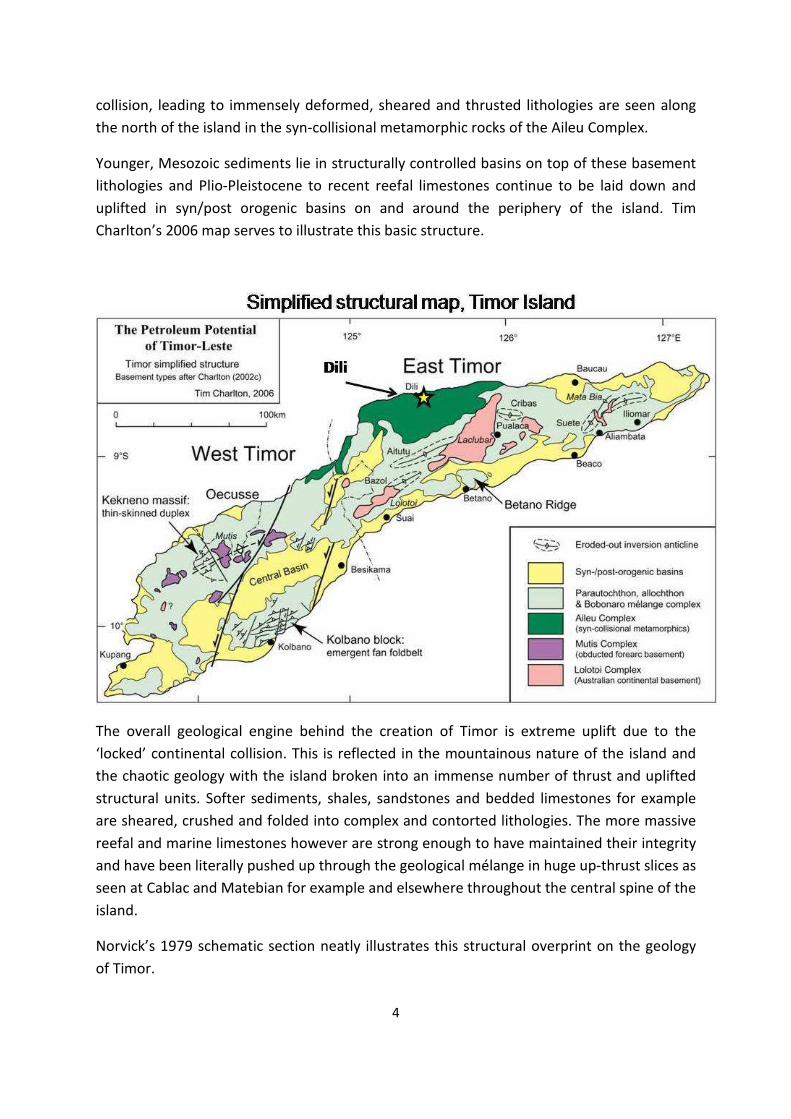
The overall geological engine behind the creation of Timor is extreme uplift due to the
‘locked’ continental collision. This is reflected in the mountainous nature of the island and
the chaotic geology with the island broken into an immense number of thrust and uplifted
structural units. Softer sediments, shales, sandstones and bedded limestones for example
are sheared, crushed and folded into complex and contorted lithologies. The more massive
reefal and marine limestones however are strong enough to have maintained their integrity
and have been literally pushed up through the geological mélange in huge up-thrust slices as
seen at Cablac and Matebian for example and elsewhere throughout the central spine of the
island.
Norvick’s 1979 schematic section neatly illustrates this structural overprint on the geology
of Timor.
5
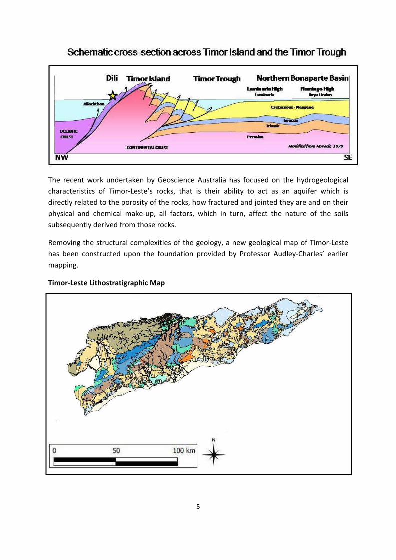
The recent work undertaken by Geoscience Australia has focused on the hydrogeological
characteristics of Timor-Leste’s rocks, that is their ability to act as an aquifer which is
directly related to the porosity of the rocks, how fractured and jointed they are and on their
physical and chemical make-up, all factors, which in turn, affect the nature of the soils
subsequently derived from those rocks.
Removing the structural complexities of the geology, a new geological map of Timor-Leste
has been constructed upon the foundation provided by Professor Audley-Charles’ earlier
mapping.
Timor-Leste Lithostratigraphic Map
6
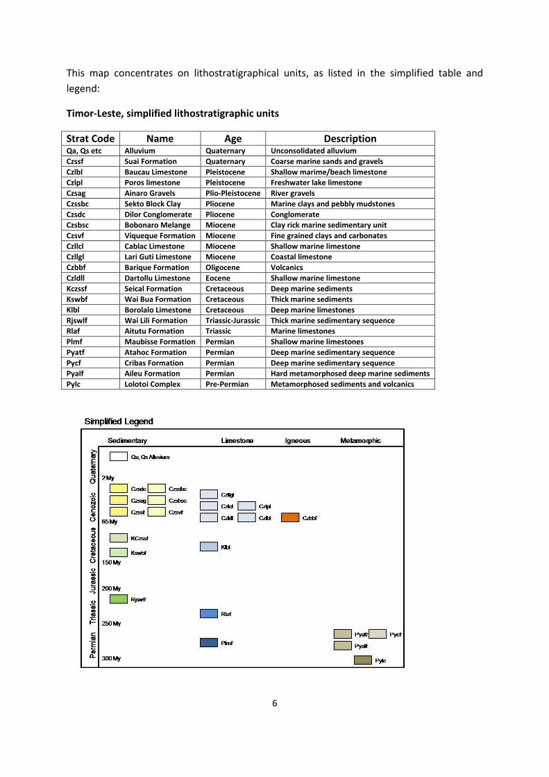
This map concentrates on lithostratigraphical units, as listed in the simplified table and
legend:
Timor-Leste, simplified lithostratigraphic units
Strat Code Name Age Description Qa, Qs etc Alluvium Quaternary Unconsolidated alluvium
Czssf Suai Formation Quaternary Coarse marine sands and gravels
Czlbl Baucau Limestone Pleistocene Shallow marime/beach limestone
Czlpl Poros limestone Pleistocene Freshwater lake limestone
Czsag Ainaro Gravels Plio-Pleistocene River gravels
Czssbc Sekto Block Clay Pliocene Marine clays and pebbly mudstones
Czsdc Dilor Conglomerate Pliocene Conglomerate
Czsbsc Bobonaro Melange Miocene Clay rick marine sedimentary unit
Czsvf Viqueque Formation Miocene Fine grained clays and carbonates
Czllcl Cablac Limestone Miocene Shallow marine limestone
Czllgl Lari Guti Limestone Miocene Coastal limestone
Czbbf Barique Formation Oligocene Volcanics
Czldll Dartollu Limestone Eocene Shallow marine limestone
Kczssf Seical Formation Cretaceous Deep marine sediments
Kswbf Wai Bua Formation Cretaceous Thick marine sediments
Klbl Borolalo Limestone Cretaceous Deep marine limestones
Rjswlf Wai Lili Formation Triassic-Jurassic Thick marine sedimentary sequence
Rlaf Aitutu Formation Triassic Marine limestones
Plmf Maubisse Formation Permian Shallow marine limestones
Pyatf Atahoc Formation Permian Deep marine sedimentary sequence
Pycf Cribas Formation Permian Deep marine sedimentary sequence
Pyalf Aileu Formation Permian Hard metamorphosed deep marine sediments
Pylc Lolotoi Complex Pre-Permian Metamorphosed sediments and volcanics
7
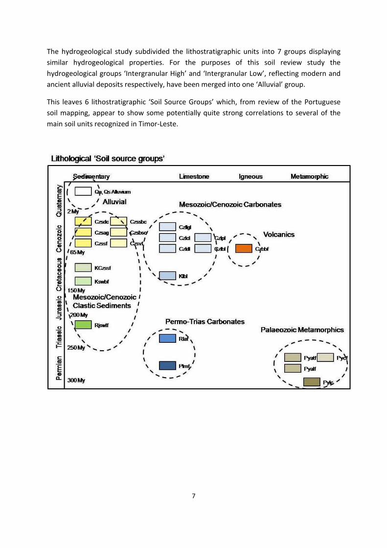
The hydrogeological study subdivided the lithostratigraphic units into 7 groups displaying
similar hydrogeological properties. For the purposes of this soil review study the
hydrogeological groups ‘Intergranular High’ and ‘Intergranular Low’, reflecting modern and
ancient alluvial deposits respectively, have been merged into one ‘Alluvial’ group.
This leaves 6 lithostratigraphic ‘Soil Source Groups’ which, from review of the Portuguese
soil mapping, appear to show some potentially quite strong correlations to several of the
main soil units recognized in Timor-Leste.
8
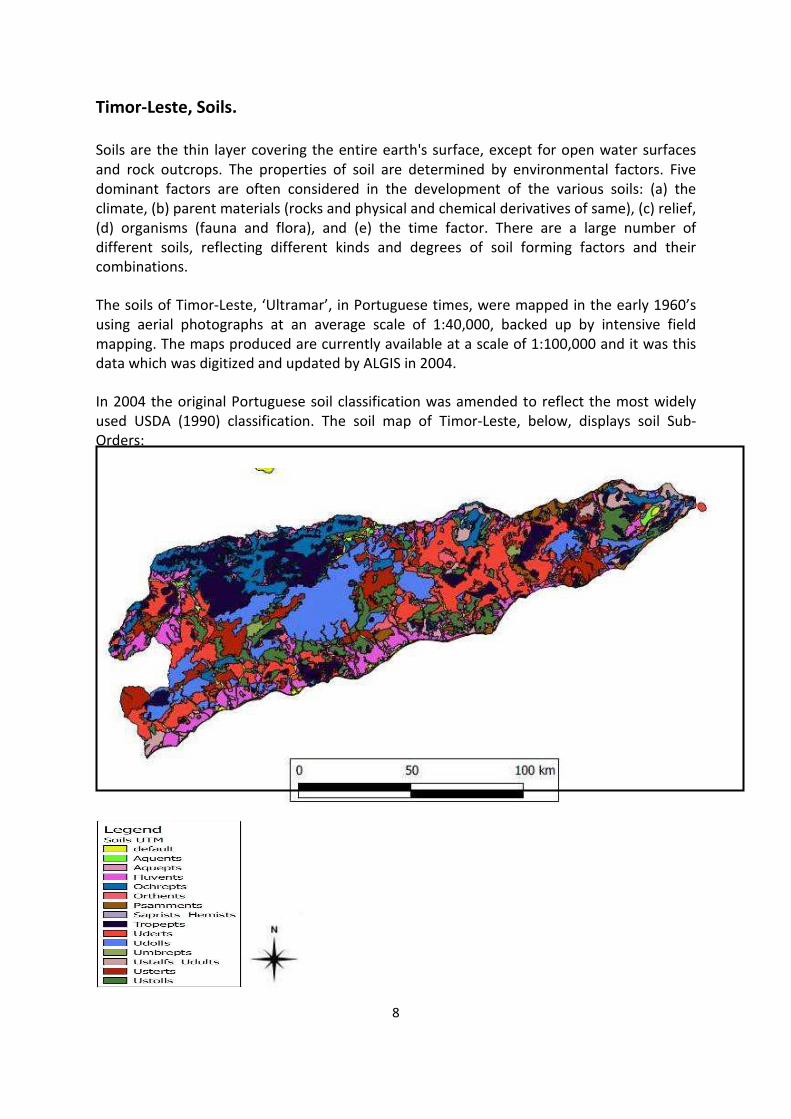
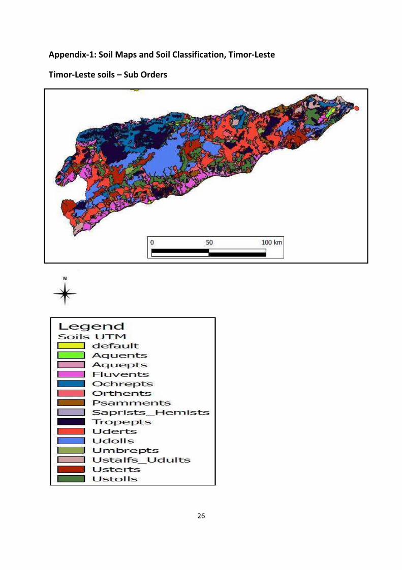
Timor-Leste, Soils.
Soils are the thin layer covering the entire earth's surface, except for open water surfaces
and rock outcrops. The properties of soil are determined by environmental factors. Five
dominant factors are often considered in the development of the various soils: (a) the
climate, (b) parent materials (rocks and physical and chemical derivatives of same), (c) relief,
(d) organisms (fauna and flora), and (e) the time factor. There are a large number of
different soils, reflecting different kinds and degrees of soil forming factors and their
combinations.
The soils of Timor-Leste, ‘Ultramar’, in Portuguese times, were mapped in the early 1960’s
using aerial photographs at an average scale of 1:40,000, backed up by intensive field
mapping. The maps produced are currently available at a scale of 1:100,000 and it was this
data which was digitized and updated by ALGIS in 2004.
In 2004 the original Portuguese soil classification was amended to reflect the most widely
used USDA (1990) classification. The soil map of Timor-Leste, below, displays soil Sub-
Orders:
9
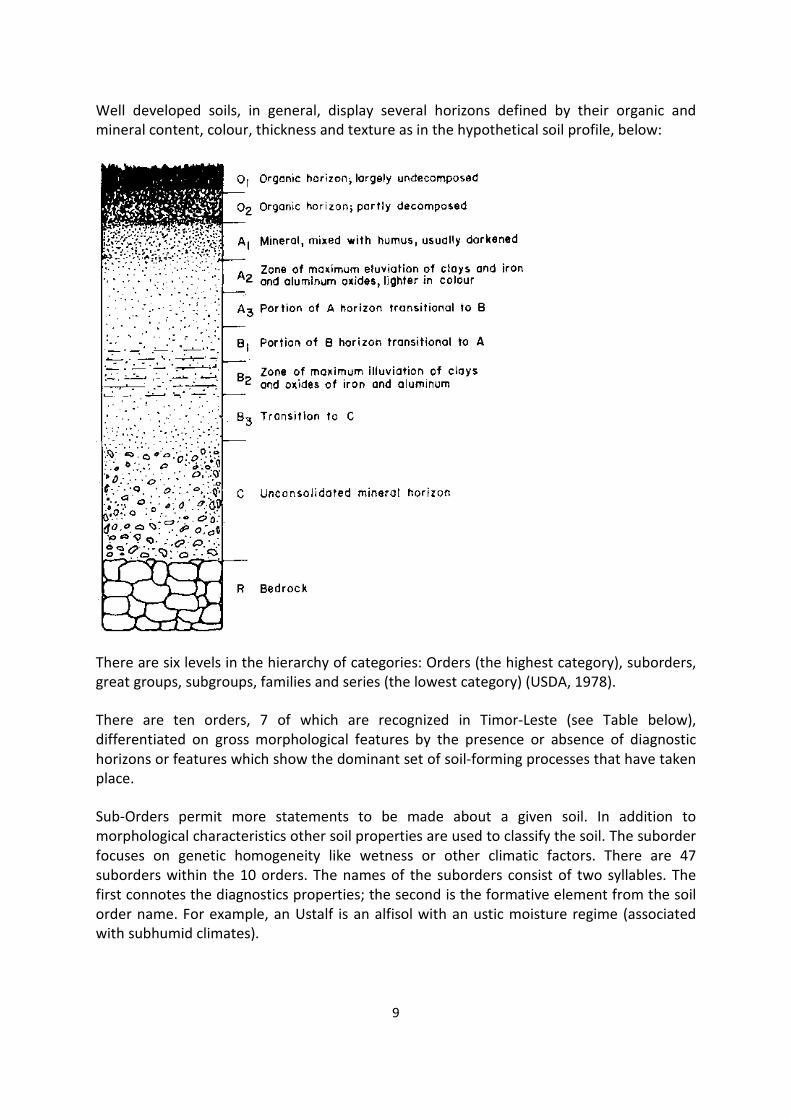
Well developed soils, in general, display several horizons defined by their organic and
mineral content, colour, thickness and texture as in the hypothetical soil profile, below:
There are six levels in the hierarchy of categories: Orders (the highest category), suborders,
great groups, subgroups, families and series (the lowest category) (USDA, 1978).
There are ten orders, 7 of which are recognized in Timor-Leste (see Table below),
differentiated on gross morphological features by the presence or absence of diagnostic
horizons or features which show the dominant set of soil-forming processes that have taken
place.
Sub-Orders permit more statements to be made about a given soil. In addition to
morphological characteristics other soil properties are used to classify the soil. The suborder
focuses on genetic homogeneity like wetness or other climatic factors. There are 47
suborders within the 10 orders. The names of the suborders consist of two syllables. The
first connotes the diagnostics properties; the second is the formative element from the soil
order name. For example, an Ustalf is an alfisol with an ustic moisture regime (associated
with subhumid climates).
10
Brief descriptions of the ten soil orders according to USDA (United States Department of
Agriculture) 1990 Soil Taxonomy. (√ Recognized in T-L)
SOIL ORDERS DESCRIPTION Typical Profile
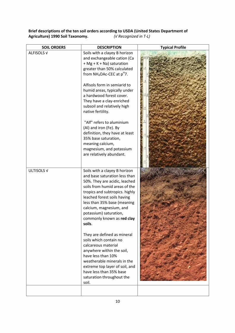
ALFISOLS √ Soils with a clayey B horizon
and exchangeable cation (Ca
+ Mg + K + Na) saturation
greater than 50% calculated
from NH4OAc-CEC at pH7.
Alfisols form in semiarid to
humid areas, typically under
a hardwood forest cover.
They have a clay-enriched
subsoil and relatively high
native fertility.
"Alf" refers to aluminium
(Al) and iron (Fe). By
definition, they have at least
35% base saturation,
meaning calcium,
magnesium, and potassium
are relatively abundant.
ULTISOLS √ Soils with a clayey B horizon
and base saturation less than
50%. They are acidic, leached
soils from humid areas of the
tropics and subtropics. highly
leached forest soils having
less than 35% base (meaning
calcium, magnesium, and
potassium) saturation,
commonly known as red clay
soils.
They are defined as mineral
soils which contain no
calcareous material
anywhere within the soil,
have less than 10%
weatherable minerals in the
extreme top layer of soil, and
have less than 35% base
saturation throughout the
soil.
11
SOIL ORDERS DESCRIPTION Typical Profile
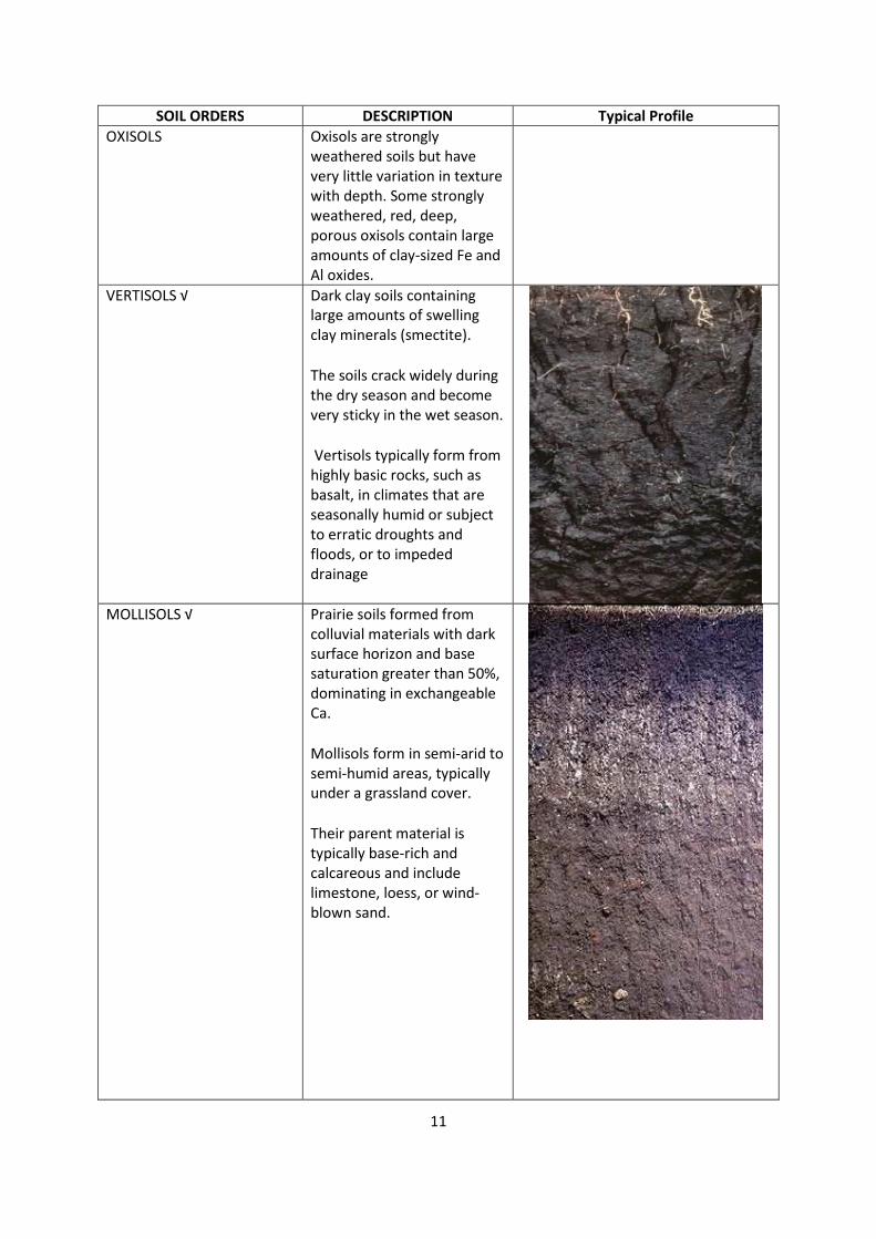
OXISOLS Oxisols are strongly
weathered soils but have
very little variation in texture
with depth. Some strongly
weathered, red, deep,
porous oxisols contain large
amounts of clay-sized Fe and
Al oxides.
VERTISOLS √ Dark clay soils containing
large amounts of swelling
clay minerals (smectite).
The soils crack widely during
the dry season and become
very sticky in the wet season.
Vertisols typically form from
highly basic rocks, such as
basalt, in climates that are
seasonally humid or subject
to erratic droughts and
floods, or to impeded
drainage
MOLLISOLS √
Prairie soils formed from
colluvial materials with dark
surface horizon and base
saturation greater than 50%,
dominating in exchangeable
Ca.
Mollisols form in semi-arid to
semi-humid areas, typically
under a grassland cover.
Their parent material is
typically base-rich and
calcareous and include
limestone, loess, or wind-
blown sand.
12
SOIL ORDERS DESCRIPTION Typical Profile
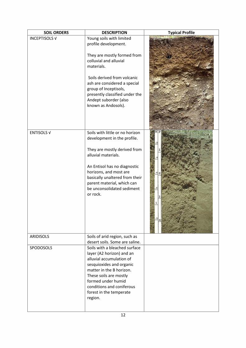
INCEPTISOLS √ Young soils with limited
profile development.
They are mostly formed from
colluvial and alluvial
materials.
Soils derived from volcanic
ash are considered a special
group of Inceptisols,
presently classified under the
Andept suborder (also
known as Andosols).
ENTISOLS √ Soils with little or no horizon
development in the profile.
They are mostly derived from
alluvial materials.
An Entisol has no diagnostic
horizons, and most are
basically unaltered from their
parent material, which can
be unconsolidated sediment
or rock.
ARIDISOLS Soils of arid region, such as
desert soils. Some are saline.
SPODOSOLS Soils with a bleached surface
layer (A2 horizon) and an
alluvial accumulation of
sesquioxides and organic
matter in the B horizon.
These soils are mostly
formed under humid
conditions and coniferous
forest in the temperate
region.
13
SOIL ORDERS DESCRIPTION Typical Profile
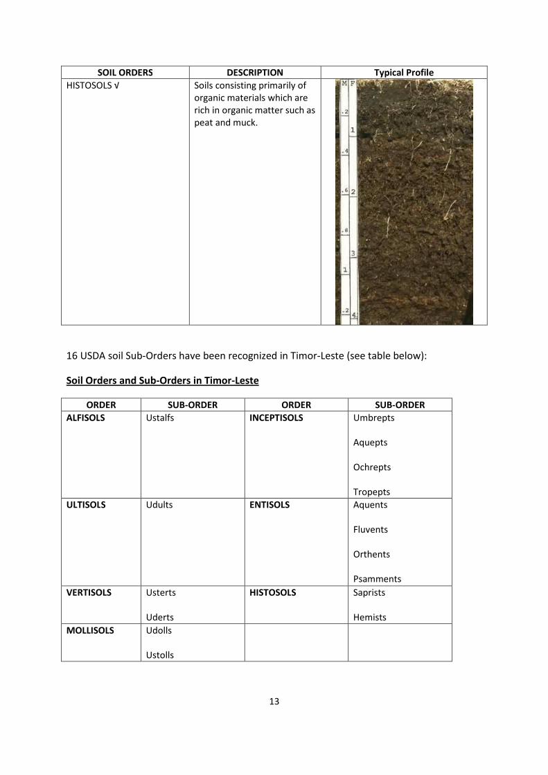
HISTOSOLS √ Soils consisting primarily of
organic materials which are
rich in organic matter such as
peat and muck.
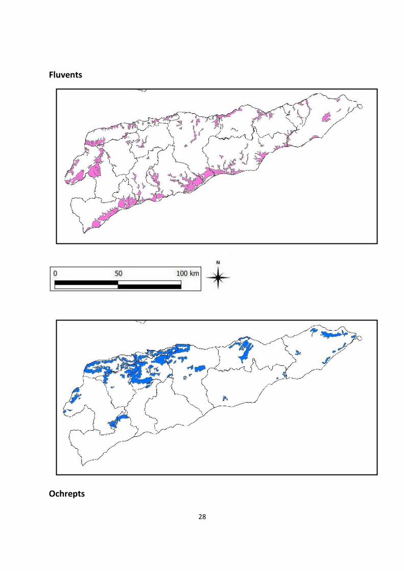
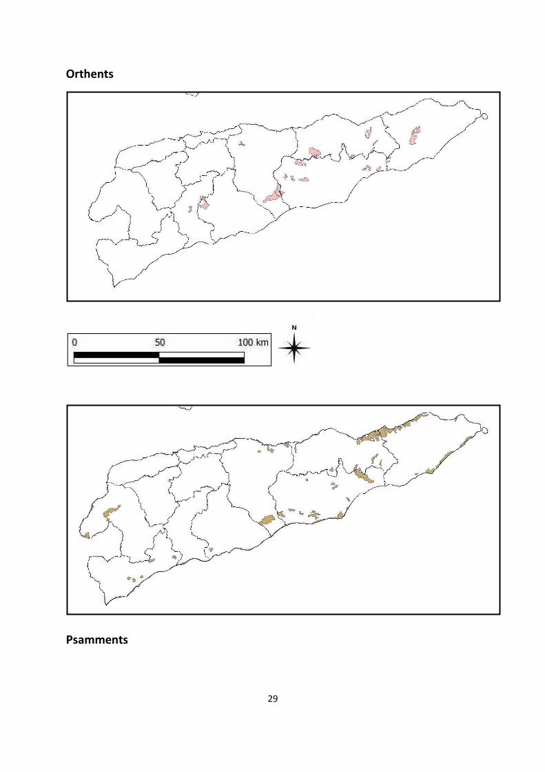
16 USDA soil Sub-Orders have been recognized in Timor-Leste (see table below):
Soil Orders and Sub-Orders in Timor-Leste
ORDER SUB-ORDER ORDER SUB-ORDER
ALFISOLS
Ustalfs INCEPTISOLS
Umbrepts
Aquepts
Ochrepts
Tropepts
ULTISOLS
Udults ENTISOLS
Aquents
Fluvents
Orthents
Psamments
VERTISOLS
Usterts
Uderts
HISTOSOLS
Saprists
Hemists
MOLLISOLS
Udolls
Ustolls
14
It is at the level of Sub-Orders that soil distributions have been mapped using the 2004
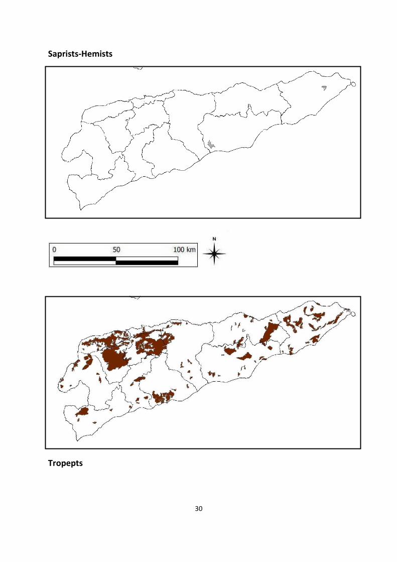
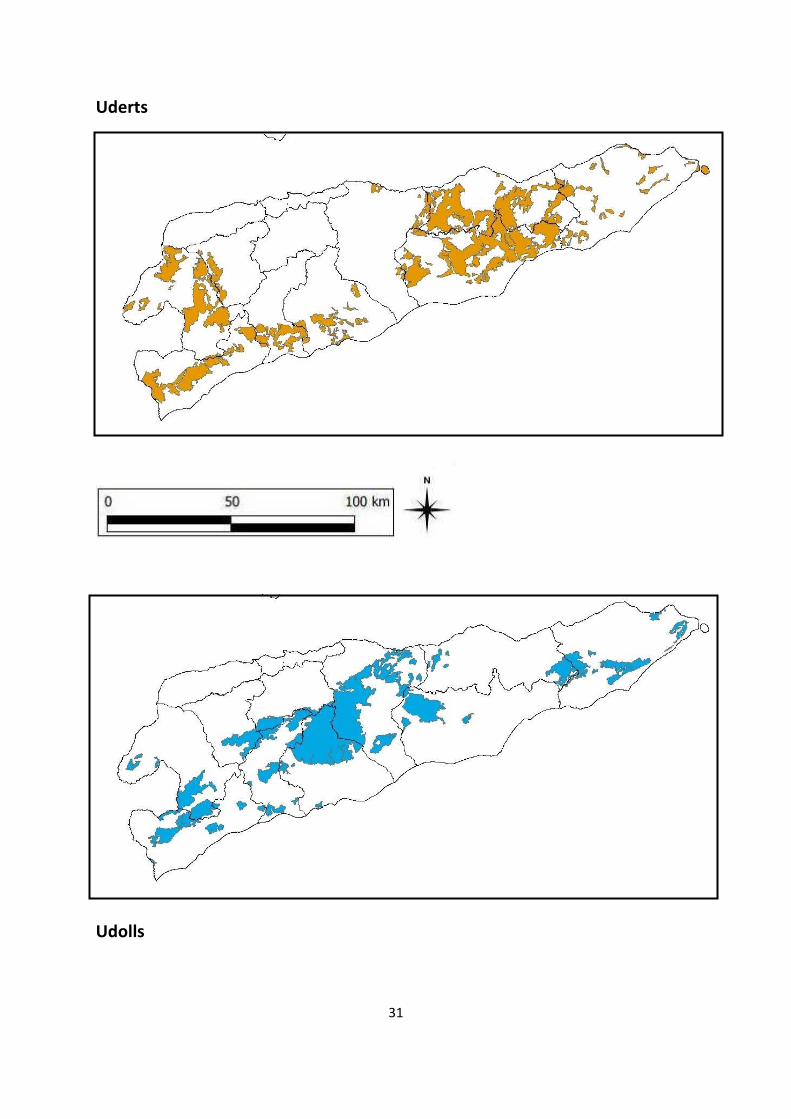
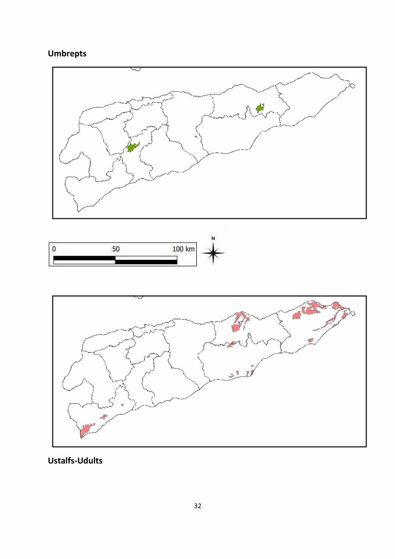
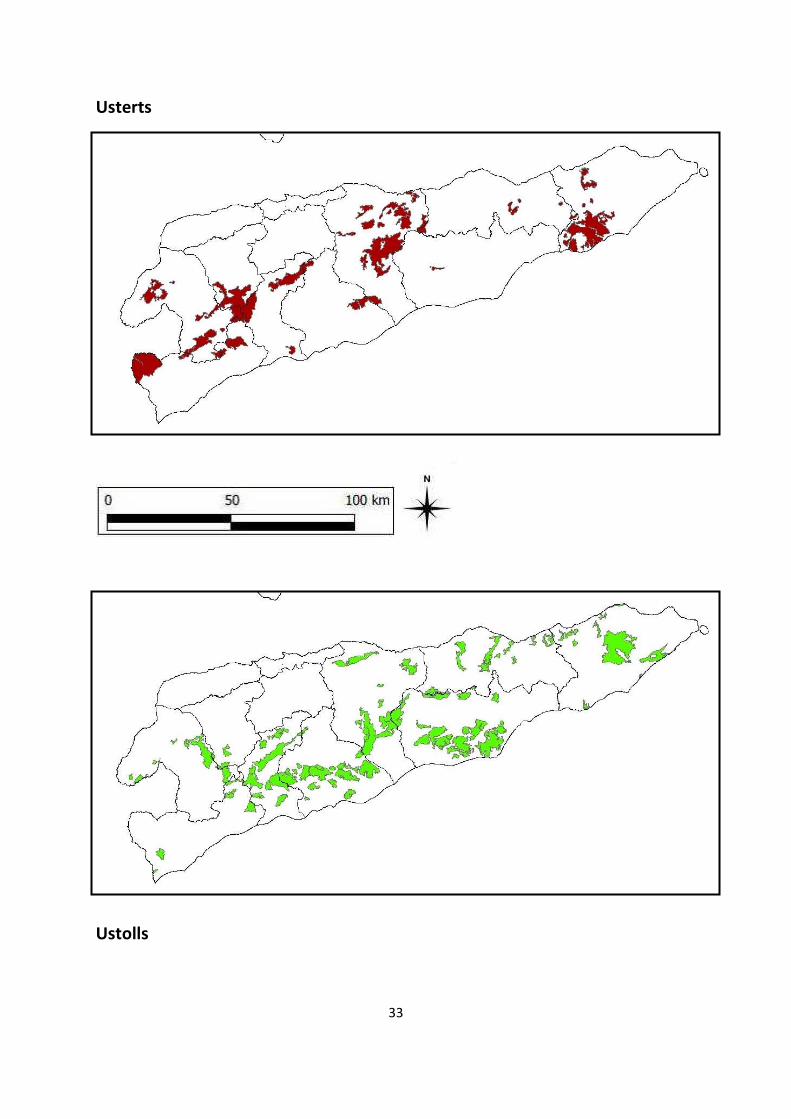
digital data. The complete set of 14 soil Sub-Order distribution maps (Saprists/Hemists and
Ustalfs/Udults maps having been combined) is presented in Appendix-1.
Also in Appendix-1 a detailed table is presented in which USDA Order and Sub-Order soil
definitions are taken down to the level of individual soil codes and example soil descriptions
from the original Portuguese soil survey. As soil study in Timor-Leste progresses this
information may provide a useful tool for field descriptions of Timorese soils linked directly
back to the standardized USDA soil classification system.
15
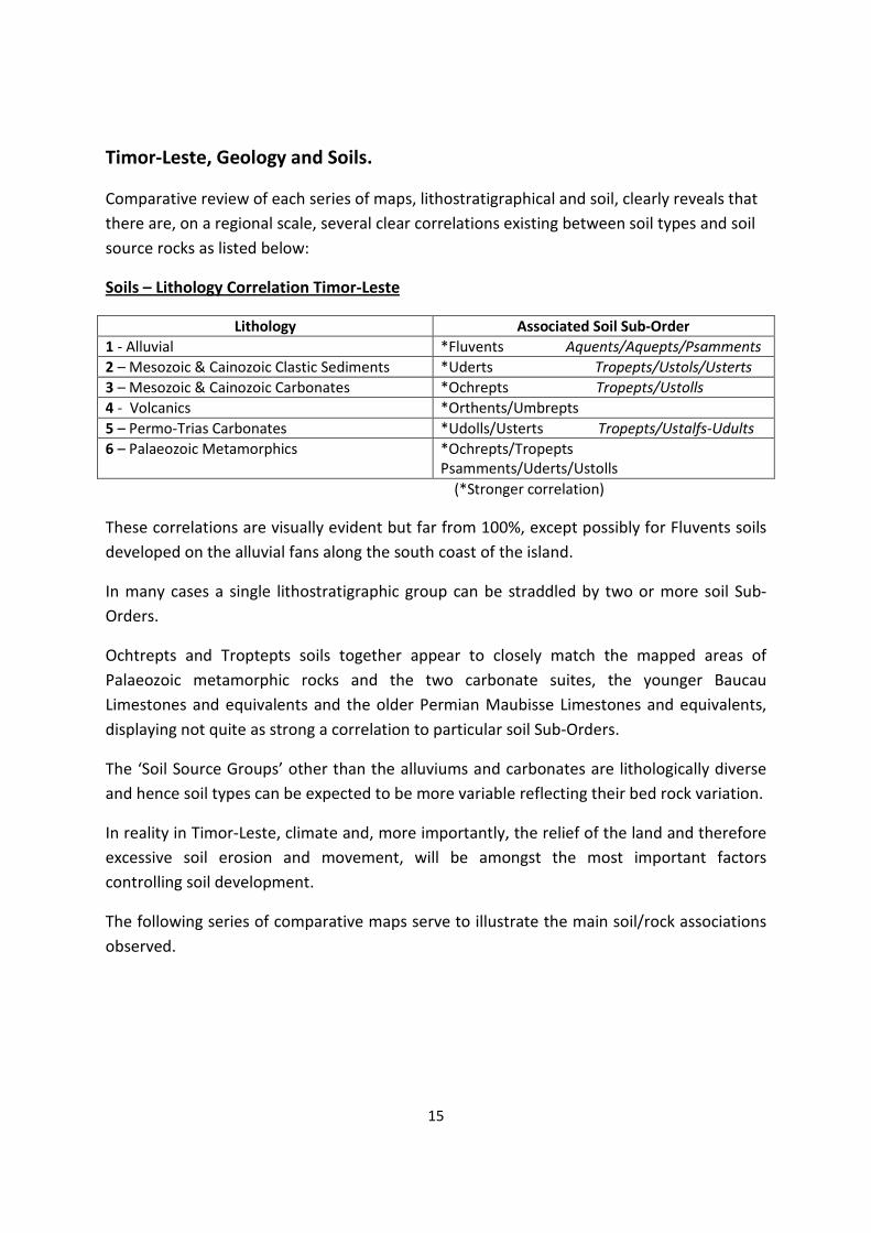
Timor-Leste, Geology and Soils.
Comparative review of each series of maps, lithostratigraphical and soil, clearly reveals that
there are, on a regional scale, several clear correlations existing between soil types and soil
source rocks as listed below:
Soils – Lithology Correlation Timor-Leste
Lithology Associated Soil Sub-Order
1 - Alluvial *Fluvents Aquents/Aquepts/Psamments
2 – Mesozoic & Cainozoic Clastic Sediments *Uderts Tropepts/Ustols/Usterts
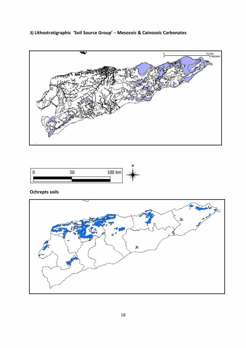
3 – Mesozoic & Cainozoic Carbonates *Ochrepts Tropepts/Ustolls
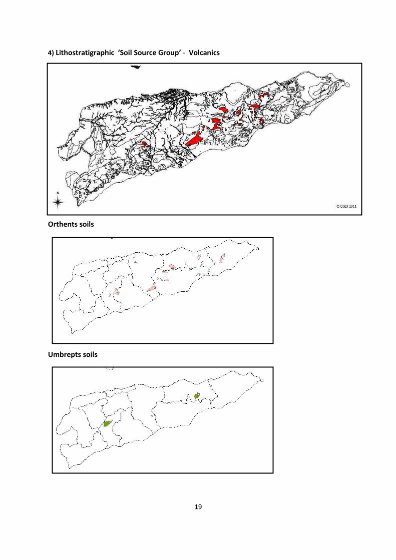
4 - Volcanics *Orthents/Umbrepts
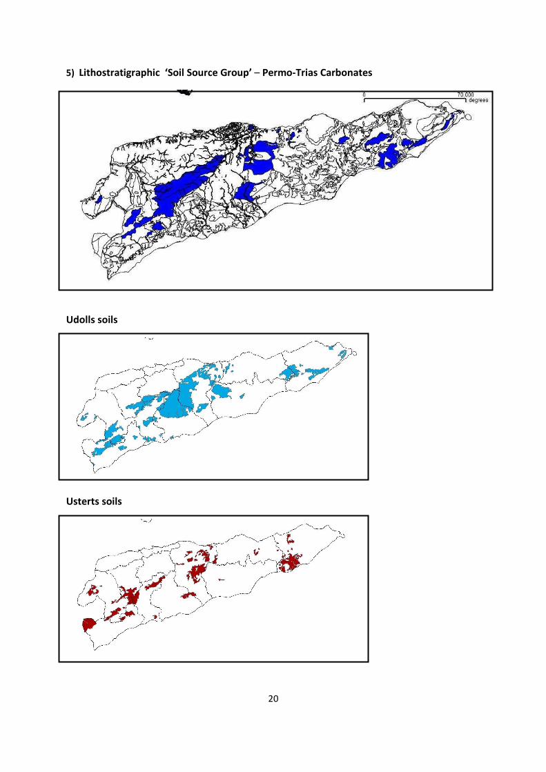
5 – Permo-Trias Carbonates *Udolls/Usterts Tropepts/Ustalfs-Udults
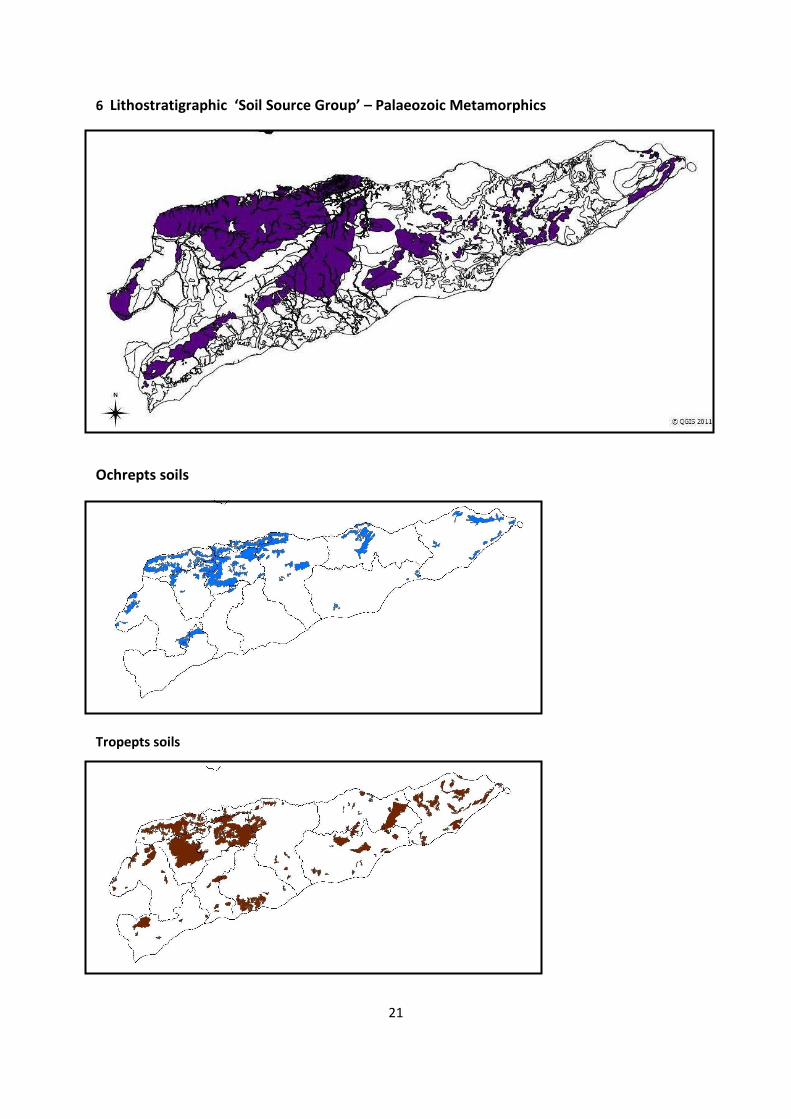
6 – Palaeozoic Metamorphics *Ochrepts/Tropepts
Psamments/Uderts/Ustolls
(*Stronger correlation)
These correlations are visually evident but far from 100%, except possibly for Fluvents soils
developed on the alluvial fans along the south coast of the island.
In many cases a single lithostratigraphic group can be straddled by two or more soil Sub-
Orders.
Ochtrepts and Troptepts soils together appear to closely match the mapped areas of
Palaeozoic metamorphic rocks and the two carbonate suites, the younger Baucau
Limestones and equivalents and the older Permian Maubisse Limestones and equivalents,
displaying not quite as strong a correlation to particular soil Sub-Orders.
The ‘Soil Source Groups’ other than the alluviums and carbonates are lithologically diverse
and hence soil types can be expected to be more variable reflecting their bed rock variation.
In reality in Timor-Leste, climate and, more importantly, the relief of the land and therefore
excessive soil erosion and movement, will be amongst the most important factors
controlling soil development.
The following series of comparative maps serve to illustrate the main soil/rock associations
observed.
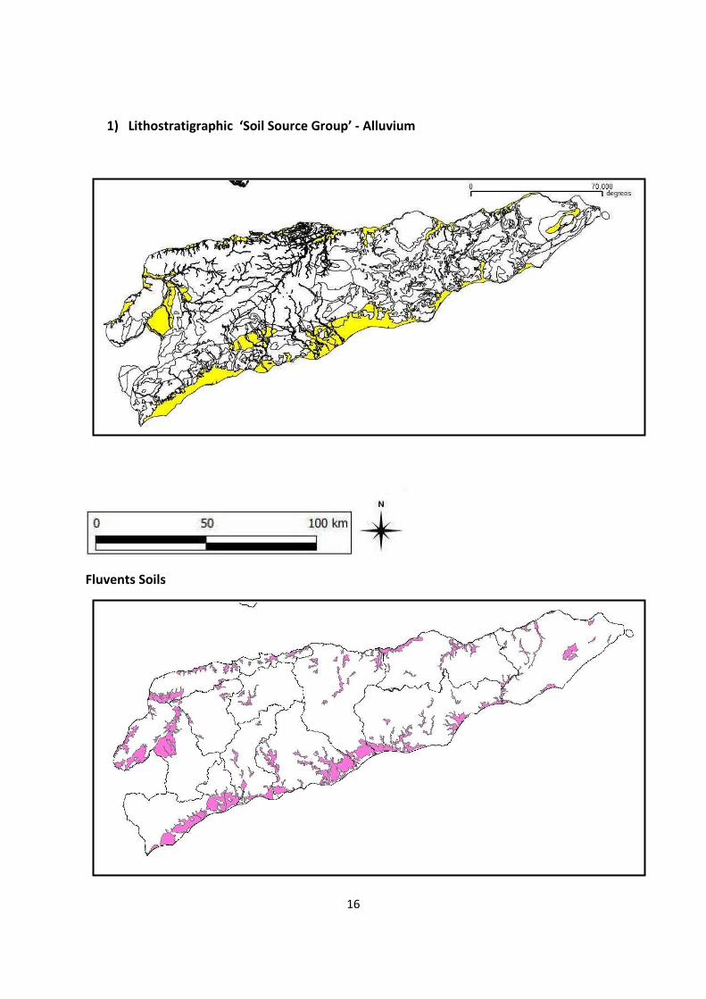
16
1) Lithostratigraphic ‘Soil Source Group’ - Alluvium
Fluvents Soils
17
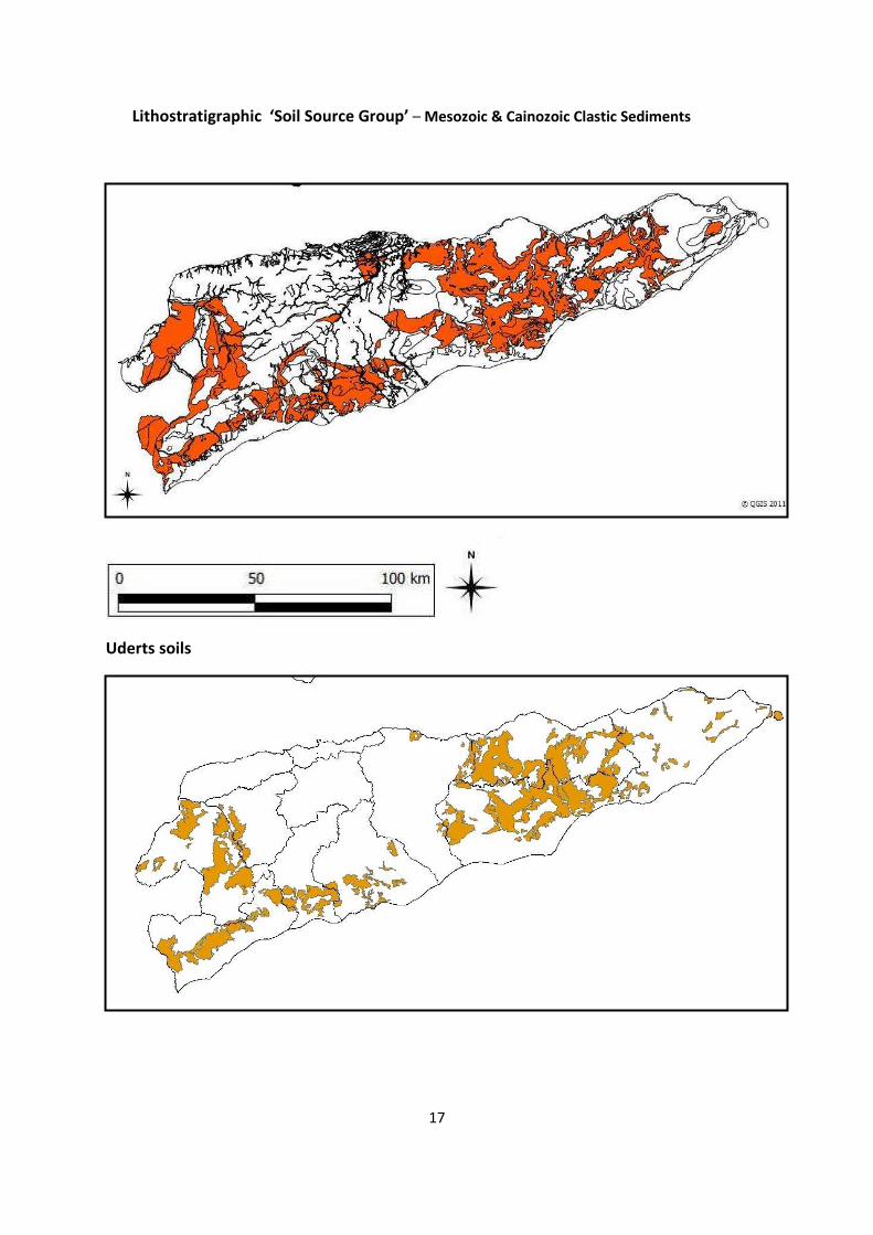
Lithostratigraphic ‘Soil Source Group’ – Mesozoic & Cainozoic Clastic Sediments
Uderts soils
18
3) Lithostratigraphic ‘Soil Source Group’ – Mesozoic & Cainozoic Carbonates
Ochrepts soils
19
4) Lithostratigraphic ‘Soil Source Group’ - Volcanics
Orthents soils
Umbrepts soils
20
5) Lithostratigraphic ‘Soil Source Group’ – Permo-Trias Carbonates
Udolls soils
Usterts soils
21
6 Lithostratigraphic ‘Soil Source Group’ – Palaeozoic Metamorphics
Ochrepts soils
Tropepts soils
22
Timor-Leste, Geology and Soils – Discussion
The rock to soil correlations displayed in the previous section of this report, although real,
cannot currently be given a very high significance as many other factors especially relief,
climate and time affect soil generation and longevity.
As has been discussed the island of Timor is going up like a ‘Geological Cork’. This,
geomorphologically, results in very steep slopes representing the equilibrium between
geological uplift and erosion and also in exceptionally high sediment loads in the rivers
leading to extensive and thick alluvial fans and flood plains along river courses and across
the coastal plains.
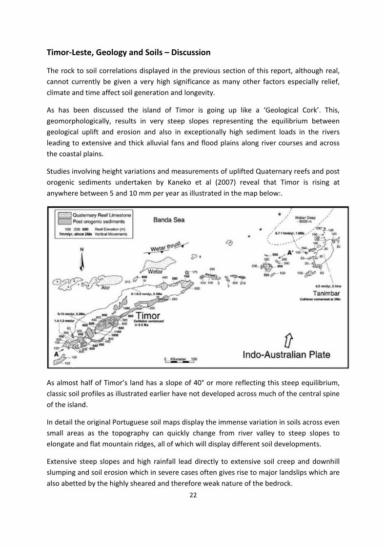
Studies involving height variations and measurements of uplifted Quaternary reefs and post
orogenic sediments undertaken by Kaneko et al (2007) reveal that Timor is rising at
anywhere between 5 and 10 mm per year as illustrated in the map below:.
As almost half of Timor’s land has a slope of 40° or more reflecting this steep equilibrium,
classic soil profiles as illustrated earlier have not developed across much of the central spine
of the island.
In detail the original Portuguese soil maps display the immense variation in soils across even
small areas as the topography can quickly change from river valley to steep slopes to
elongate and flat mountain ridges, all of which will display different soil developments.
Extensive steep slopes and high rainfall lead directly to extensive soil creep and downhill
slumping and soil erosion which in severe cases often gives rise to major landslips which are
also abetted by the highly sheared and therefore weak nature of the bedrock.
23
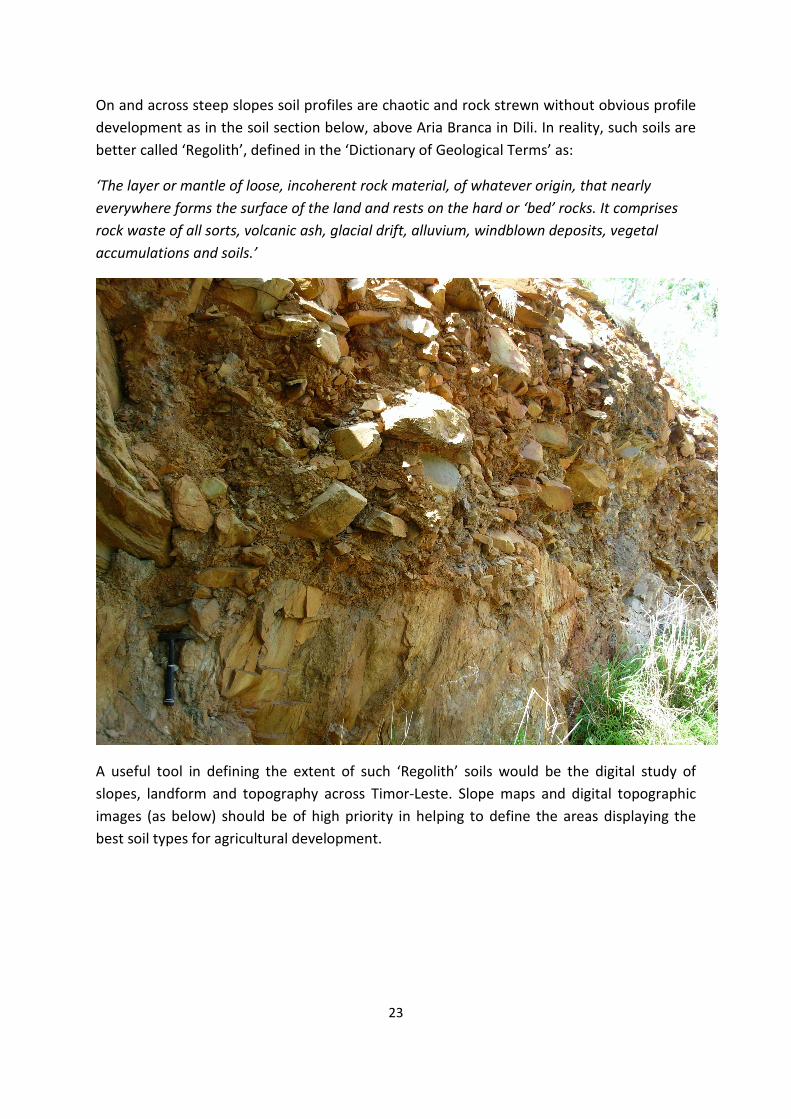
On and across steep slopes soil profiles are chaotic and rock strewn without obvious profile
development as in the soil section below, above Aria Branca in Dili. In reality, such soils are
better called ‘Regolith’, defined in the ‘Dictionary of Geological Terms’ as:
‘The layer or mantle of loose, incoherent rock material, of whatever origin, that nearly
everywhere forms the surface of the land and rests on the hard or ‘bed’ rocks. It comprises
rock waste of all sorts, volcanic ash, glacial drift, alluvium, windblown deposits, vegetal
accumulations and soils.’
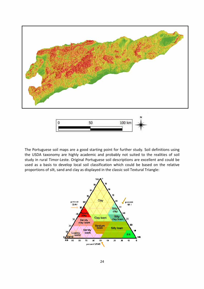
A useful tool in defining the extent of such ‘Regolith’ soils would be the digital study of
slopes, landform and topography across Timor-Leste. Slope maps and digital topographic
images (as below) should be of high priority in helping to define the areas displaying the
best soil types for agricultural development.
24
The Portuguese soil maps are a good starting point for further study. Soil definitions using
the USDA taxonomy are highly academic and probably not suited to the realities of soil
study in rural Timor-Leste. Original Portuguese soil descriptions are excellent and could be
used as a basis to develop local soil classification which could be based on the relative
proportions of silt, sand and clay as displayed in the classic soil Textural Triangle:
25
It would seem sensible to move forward from the current desk study to build such a
simplified soil classification with reference to local soils and conditions and soil fertility
across the country.
Certainly it is recommended to further define ‘type’ soil sections for each soil Sub Order in
each district and to dig and record such ‘type’ sections as ‘anchor’ points to future study of
soils in Timor-Leste.
References.
Audley-Charles, M., 1965. The Geology of Portuguese Timor. Memoirs of the Geological
Society of London, 4, 4-84.
Charlton, T.R. 2002. The petroleum potential of East Timor. APPEA Proceedings 32, 20-38.)
Charlton, T.R. et al 2002. The Permian of Timor: stratigraphy, palaeontology and
palaeogeography. Journal of Asian Earth Sciences 20 (2002) 719-774.
Kaneko et al 2007. On going orogeny in the outer arc of the Timor-Tanimbar region, eastern
Indonesia. Gondwana Research 11 (2007) pp218-23.
Norvick, M. S. 1979. The tectonic history of the Banda Arcs, eastern Indonesia; a review.
Journal of the Geological Society; v. 136; no. 5; p.519-526.
Wallace, L., Sundaram, B Brodie, R. S., Dawson, S. and Furness, L, 2011. Hydrology of Timor-
Leste. Geoscience Australia, Record 2011/XX, xxpp.
Dictionary of geological Terms. American Geological Institute, Dolphin Reference Books
Edition 1962.
United States Department of Agriculture (USDA). Soil Taxonomy webpage:
http://soils.usda.gov/technical/classification/taxonomy/
26
Appendix-1: Soil Maps and Soil Classification, Timor-Leste
Timor-Leste soils – Sub Orders
27
Aquents
Aquepts
28
Fluvents
Ochrepts
29
Orthents
Psamments
30
Saprists-Hemists
Tropepts
31
Uderts
Udolls
32
Umbrepts
Ustalfs-Udults
33
Usterts
Ustolls
34
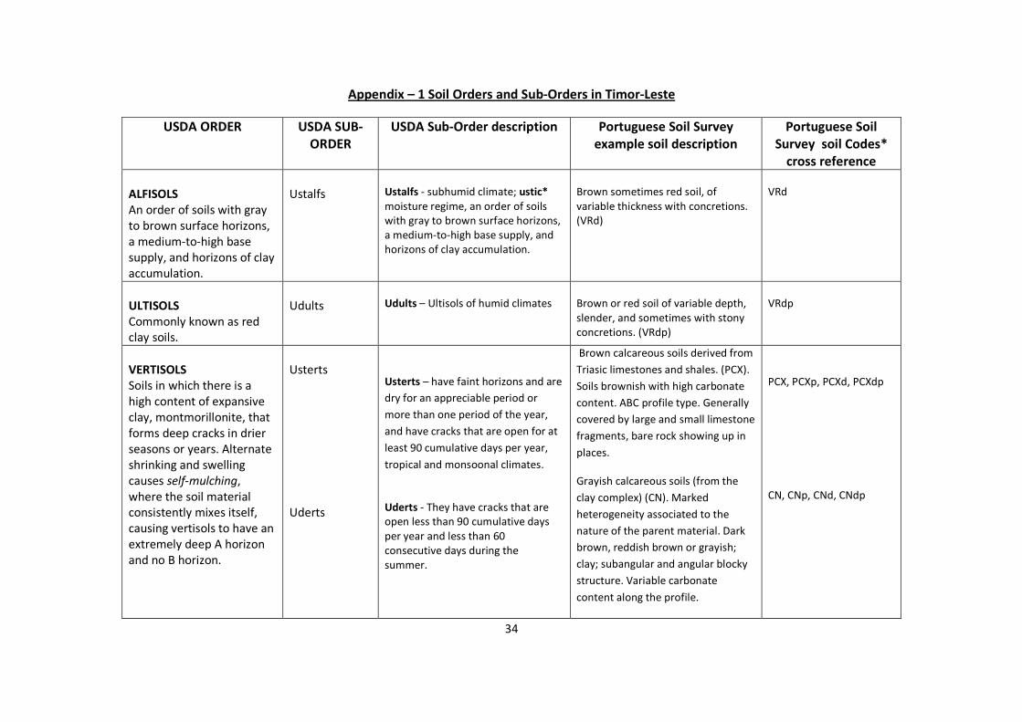
Appendix – 1 Soil Orders and Sub-Orders in Timor-Leste
USDA ORDER USDA SUB-
ORDER
USDA Sub-Order description Portuguese Soil Survey
example soil description
Portuguese Soil
Survey soil Codes*
cross reference
ALFISOLS
An order of soils with gray
to brown surface horizons,
a medium-to-high base
supply, and horizons of clay
accumulation.
Ustalfs
Ustalfs - subhumid climate; ustic*
moisture regime, an order of soils
with gray to brown surface horizons,
a medium-to-high base supply, and
horizons of clay accumulation.
Brown sometimes red soil, of
variable thickness with concretions.
(VRd)
VRd
ULTISOLS
Commonly known as red
clay soils.
Udults
Udults – Ultisols of humid climates
Brown or red soil of variable depth,
slender, and sometimes with stony
concretions. (VRdp)
VRdp
VERTISOLS
Soils in which there is a
high content of expansive
clay, montmorillonite, that
forms deep cracks in drier
seasons or years. Alternate
shrinking and swelling
causes self-mulching,
where the soil material
consistently mixes itself,
causing vertisols to have an
extremely deep A horizon
and no B horizon.
Usterts
Uderts
Usterts – have faint horizons and are
dry for an appreciable period or
more than one period of the year,
and have cracks that are open for at
least 90 cumulative days per year,
tropical and monsoonal climates.
Uderts - They have cracks that are
open less than 90 cumulative days
per year and less than 60
consecutive days during the
summer.
Brown calcareous soils derived from
Triasic limestones and shales. (PCX).
Soils brownish with high carbonate
content. ABC profile type. Generally
covered by large and small limestone
fragments, bare rock showing up in
places.
Grayish calcareous soils (from the
clay complex) (CN). Marked
heterogeneity associated to the
nature of the parent material. Dark
brown, reddish brown or grayish;
clay; subangular and angular blocky
structure. Variable carbonate
content along the profile.
PCX, PCXp, PCXd, PCXdp
CN, CNp, CNd, CNdp
35
USDA ORDER USDA SUB-
ORDER
USDA Sub-Order description Portuguese Soil Survey
example soil description
Portuguese Soil
Survey soil Codes*
cross reference
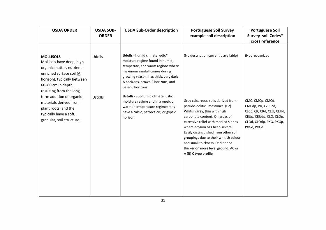
MOLLISOLS
Mollisols have deep, high
organic matter, nutrient-
enriched surface soil (A
horizon), typically between
60–80 cm in depth,
resulting from the long-
term addition of organic
materials derived from
plant roots, and the
typically have a soft,
granular, soil structure.
Udolls
Ustolls
Udolls - humid climate; udic*
moisture regime found in humid,
temperate, and warm regions where
maximum rainfall comes during
growing season; has thick, very dark
A horizons, brown B horizons, and
paler C horizons.
Ustolls - subhumid climate; ustic
moisture regime and in a mesic or
warmer temperature regime; may
have a calcic, petrocalcic, or gypsic
horizon.
(No description currently available)
Gray calcareous soils derived from
pseudo-oolitic limestones. (CZ)
Whitish gray, thin with high
carbonate content. On areas of
excessive relief with marked slopes
where erosion has been severe.
Easily distinguished from other soil
groupings due to their whitish colour
and small thickness. Darker and
thicker on more level ground. AC or
A (B) C type profile
(Not recognized)
CMC, CMCp, CMCd,
CMCdp, PA, CZ, CZd,
Czdp, CR, CRd, CEU, CEUd,
CEUp, CEUdp, CLO, CLOp,
CLOd, CLOdp, PXG, PXGp,
PXGd, PXGd.

36
USDA ORDER USDA SUB-
ORDER
USDA Sub-Order description Portuguese Soil Survey
example soil description
Portuguese Soil
Survey soil Codes*
cross reference
INCEPTISOLS
Soils that form quickly
through alteration of
parent material. They have
no accumulation of clays,
Iron, Aluminum or organic
matter. They have a
dominant ochreous a
cambic, brown earth,
subsurface horizon.
Umbrepts
Aquepts
Ochrepts
Tropepts
Umbrepts - acid, freely drained,
organic-matter-rich Inceptisols,
displays a dark A horizon more than
25 cm. thick, brown B horizons, and
slightly paler C horizons; soil is
strongly acid, and clay minerals are
crystalline.
Aquepts - Inceptisols with a water
table at or near the surface for much
of the year.
Ochrepts - characterised by a warm
soil temperature regime and an ustic
soil moisture regime, lacking clay,
sesquioxides, or humus and
characerised by an upper surface
with too little organic matter and
light colour.
Tropepts - characterized by
moderately dark A horizons with
modest additions of organic matter,
B horizons with brown or reddish
colors, and slightly pale C horizons;
restricted to tropical regions with
moderate or high rainfall.
Soil texture medium brown, thin and
stony. (CDdp)
Soil texture medium to heavy,
yellowish to grey, deep and
moderately stained. (AS)
Red calcareous soils from pinkish
limestone associated with igneous
rocks. (VCe). Reddish brown clay,
blocky structure. Often found
alternating with soils derived from
igneous rocks and shales. Profile of
the ABR type
Brown calcareous soils from
limestone. (PF). Little developed,
variable carbonate content along the
profile. Grayish brown clay, when
shallow containing a great deal of
limestone fragments lying at the
surface. Profile of the AC type,
sometimes ABC type.
CDdp, CPdp.
AS.
VX, VXp, VXd, VXdp, VCe,
AR.
PF, PFp, PFd, PFdp, CFD,
CFDp, CFDdp, PCC, PCCp,
PCCd, PCCdp, VR, Vrp.
37
USDA ORDER USDA SUB-
ORDER
USDA Sub-Order description Portuguese Soil Survey
example soil description
Portuguese Soil
Survey soil Codes*
cross reference
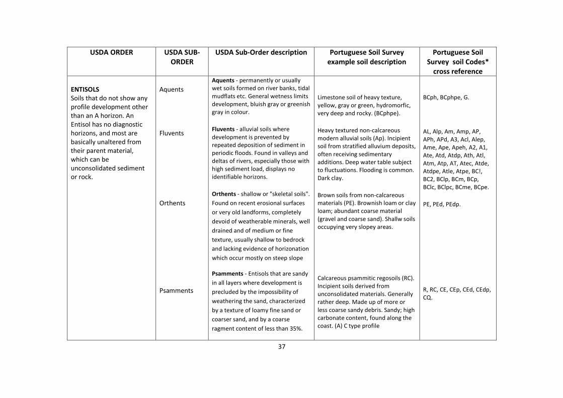
ENTISOLS
Soils that do not show any
profile development other
than an A horizon. An
Entisol has no diagnostic
horizons, and most are
basically unaltered from
their parent material,
which can be
unconsolidated sediment
or rock.
Aquents
Fluvents
Orthents
Psamments
Aquents - permanently or usually
wet soils formed on river banks, tidal
mudflats etc. General wetness limits
development, bluish gray or greenish
gray in colour.
Fluvents - alluvial soils where
development is prevented by
repeated deposition of sediment in
periodic floods. Found in valleys and
deltas of rivers, especially those with
high sediment load, displays no
identifiable horizons.
Orthents - shallow or "skeletal soils".
Found on recent erosional surfaces
or very old landforms, completely
devoid of weatherable minerals, well
drained and of medium or fine
texture, usually shallow to bedrock
and lacking evidence of horizonation
which occur mostly on steep slope
Psamments - Entisols that are sandy
in all layers where development is
precluded by the impossibility of
weathering the sand, characterized
by a texture of loamy fine sand or
coarser sand, and by a coarse
ragment content of less than 35%.
Limestone soil of heavy texture,
yellow, gray or green, hydromorfic,
very deep and rocky. (BCphpe).
Heavy textured non-calcareous
modern alluvial soils (Ap). Incipient
soil from stratified alluvium deposits,
often receiving sedimentary
additions. Deep water table subject
to fluctuations. Flooding is common.
Dark clay.
Brown soils from non-calcareous
materials (PE). Brownish loam or clay
loam; abundant coarse material
(gravel and coarse sand). Shallw soils
occupying very slopey areas.
Calcareous psammitic regosoils (RC).
Incipient soils derived from
unconsolidated materials. Generally
rather deep. Made up of more or
less coarse sandy debris. Sandy; high
carbonate content, found along the
coast. (A) C type profile
BCph, BCphpe, G.
AL, Alp, Am, Amp, AP,
APh, APd, A3, Acl, Alep,
Ame, Ape, Apeh, A2, A1,
Ate, Atd, Atdp, Ath, Atl,
Atm, Atp, AT, Atec, Atde,
Atdpe, Atle, Atpe, BC!,
BC2, BClp, BCm, BCp,
BClc, BClpc, BCme, BCpe.
PE, PEd, PEdp.
R, RC, CE, CEp, CEd, CEdp,
CQ.
38
USDA ORDER USDA SUB-
ORDER
USDA Sub-Order description Portuguese Soil Survey
example soil description
Portuguese Soil
Survey soil Codes*
cross reference
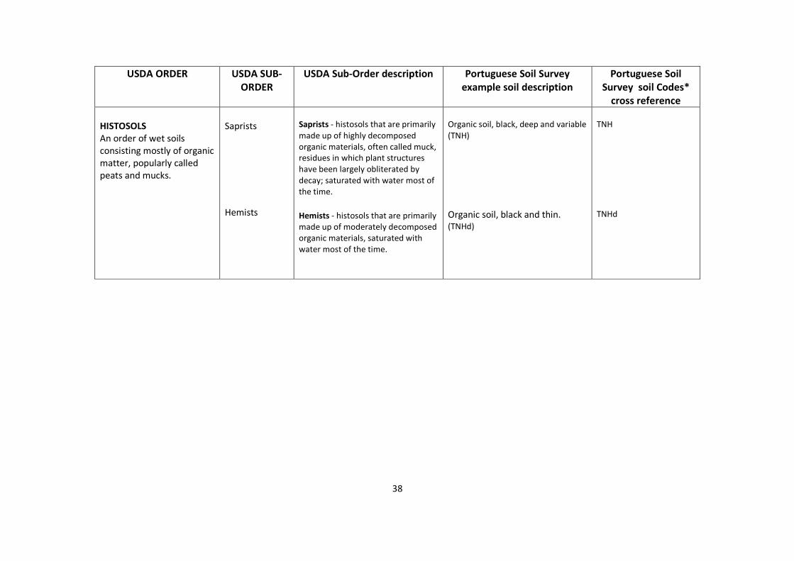
HISTOSOLS
An order of wet soils
consisting mostly of organic
matter, popularly called
peats and mucks.
Saprists
Hemists
Saprists - histosols that are primarily
made up of highly decomposed
organic materials, often called muck,
residues in which plant structures
have been largely obliterated by
decay; saturated with water most of
the time.
Hemists - histosols that are primarily
made up of moderately decomposed
organic materials, saturated with
water most of the time.
Organic soil, black, deep and variable
(TNH)
Organic soil, black and thin.
(TNHd)
TNH
TNHd
39
Notes:
* Soil Codes: Upper case letters define the Portuguese ‘Soil Associations’ approximately equivalent to USDA soil ‘Orders’. Lower case letters define descriptive comments, eg. e
= ‘Thick’, h = ‘Thin’, p = ‘Stony’, d = ‘Drained’.
*Ustic moisture regime : The ustic (L. ustus, burnt; implying dryness) moisture regime is intermediate between the aridic regime and the udic regime. Its concept is one of moisture that is limited
but is present at a time when conditions are suitable for plant growth. The concept of the ustic moisture regime is not applied to soils that have permafrost or a cryic soil temperature regime (defined
below). If the mean annual soil temperature is 22° C or higher or if the mean summer and winter soil temperatures differ by less than 6° C at a depth of 50 cm below the soil surface, the soil moisture
control section in areas of the ustic moisture regime is dry in some or all parts for 90 or more cumulative days in normal years. It is moist, however, in some part either for more than 180 cumulative
days per year or for 90 or more consecutive days.
If the mean annual soil temperature is lower than 22° C and if the mean summer and winter soil temperatures differ by 6° C or more at a depth of 50 cm from the soil surface, the soil moisture control
section in areas of the ustic moisture regime is dry in some or all parts for 90 or more cumulative days in normal years, but it is not dry in all parts for more than half of the cumulative days when the
soil temperature at a depth of 50 cm is higher than 5° C. If in normal years the moisture control section is moist in all parts for 45 or more consecutive days in the 4 months following the winter
solstice, the moisture control section is dry in all parts for less than 45 consecutive days in the 4 months following the summer solstice.
In tropical and subtropical regions that have a monsoon climate with either one or two dry seasons, summer and winter seasons have little meaning. In those regions the moisture regime is ustic if
there is at least one rainy season of 3 months or more. In temperate regions of subhumid or semiarid climates, the rainy seasons are usually spring and summer or spring and fall, but never winter.
Native plants are mostly annuals or plants that have a dormant period while the soil is dry.
*Udic moisture regime : The udic (L. udus, humid) moisture regime is one in which the soil moisture control section is not dry in any part for as long as 90 cumulative days in
normal years. If the mean annual soil temperature is lower than 22° C and if the mean winter and mean summer soil temperatures at a depth of 50 cm from the soil surface
differ by 6° C or more, the soil moisture control section, in normal years, is dry in all parts for less than 45 consecutive days in the 4 months following the summer solstice. In
addition, the udic moisture regime requires, except for short periods, a three-phase system, solid-liquid-gas, in part or all of the soil moisture control section when the soil
temperature is above 5° C.
The udic moisture regime is common to the soils of humid climates that have well distributed rainfall; have enough rain in summer so that the amount of stored moisture plus
rainfall is approximately equal to, or exceeds, the amount of evapotranspiration; or have adequate winter rains to recharge the soils and cool, foggy summers, as in coastal
areas. Water moves downward through the soils at some time in normal years.
In climates where precipitation exceeds evapotranspiration in all months of normal years, the moisture tension rarely reaches 100 kPa in the soil moisture control section,
although there are occasional brief periods when some stored moisture is used. The water moves through the soil in all months when it is not frozen. Such an extremely wet
moisture regime is called perudic (L. per, throughout in time, and L. udus, humid). In the names of most taxa, the formative element "ud" is used to indicate either a udic or a
perudic regime; the formative element "per" is used in selected taxa.