Embed Size (px)
Citation preview

GEOLOGY AND OIL DEVELOPMENT OF THE COLD BAYDISTRICT
By WALTER R. SMITH
INTRODUCTION
During the field season of 1924 the United States Geological Survey continued its investigation of the areal and structural geology in the Cold Bay district, Alaska Peninsula. Topographic and geo logic mapping of the Cold Bay and adjacent districts was begun in the spring of-1921, and progress has been made each year since that time. The results of the first three field seasons have been published in several Survey bulletins,1 to which the reader is referred for a general description of the country northeast and southwest of the Cold Bay district. In 1924 a geologic party in charge of the writer, who was assisted by E. C. Roschen, was sent into the field to make a more detailed study of some of the most promising areas which had been previously visited by members of the Geological Survey during hasty reconnaissance trips. The areas studied include Cape Ke- kurnoi, the Salmon Creek-Bear Creek anticline, the Ugashik Creek anticline, the shores of Wide Bay, and an area along the north side of Becharof Lake.
The Cold Bay district includes an indefinite area lying west of Cold, Portage, and Wide Bays on the northwest side of Shelikof Strait west of Kodiak Island. The term " Cold Bay district" has survived from the days of the oil excitement in 1902-1904, when Cold Bay was the center of activity and the place of landing for the machinery and supplies used in drilling several wells near the head of Trail Creek. At present a much larger area is generally referred to as the Cold Bay district, and in the more recent oil development, which began in 1922, the town of Kanatak, at the head of Portage Bay, 30 miles southwest of Cold Bay, has been the port of landing. Wide Bay affords greater protection from easterly storms than Port age and Cold Bays and will probably be used as a harbor in the near
1 Capps, S. R., The Cold Bay district: U. S. Geol. Survey Bull. 739, pp. 77-116. 1922. ' Smith, W. R., and Baker, A. A., The Cold Bay-Chignik district, Alaska : U. S. Geol. Sur
vey Bull. 755, pp. 151-218, 1924.Matter, K. F., Smith, W. R., and Martin, G. C., Petroleum on Alaska Peninsula : U. S.
Geol. Survey Bull. 773, pp. 159-213, 1925.78644° 26 5 63

64 MINERAL .SESOUBCES OF ALASKA, 1924
future. Local areas in the Cold Bay district are referred to as the *' east field," which lies between the Pacific coast and Becharof Lake; and the " west field," which lies south and west of Becharof Lake, in the vicinity of Mount Peulik.
GEOGRAPHY
The relief, drainage, climate, vegetation, and routes of travel in the Cold Bay district have been described in some detail in several recent publications of the Geological Survey. Only a brief summary of the most striking geographic features is given in this report.
The Alaska Peninsula is about 550 miles long and is in the form of a slightly arched wedge whose greatest width is toward the north east or landward end, from which it tapers toward the southwest. In the latitude of Cold Bay the peninsula has a width of about 90 miles. The Aleutian Kange extends the entire length of the penin sula and as far southwest as Stepovak Bay is much closer to the Pacific Ocean than to Bering Sea. The Pacific coast' is indented by many bays separated by capes that present bold headlands. The north side of the peninsula bordering Bristol Bay consists of a broad lowland less than 100 feet above sea level that contains many lakes and swamps.
In the Cold Bay district the Aleutian Kange extends about 20 miles inland from the Pacific coast or one-fourth the distance across the peninsula. The crests of many of the mountains are rounded and rise to altitudes of 1,500 to 2,500 feet, although a few sharp peaks, especially those southwest of Wide Bay, attain altitudes of nearly 4,000 feet. Mount Peulik, which is the most conspicuous topographic feature in the district, is an extinct volcano that stands south of the main arm of Becharof Lake and has an altitude of 4,800 feet.
The larger streams of the Cold Bay district rise along the north west side of the range and flow either directly into Bristol Bay or into Becharof and Ugashik Lakes, which lie west of the mountains. The Pacific drainage consists of short turbulent streams, most of which are less than 8 miles in length.
GEOLOGY
PRINCIPAL FEATURES
During a reconnaissance geologic survey 2 of the Cold Bay dis trict in 1921 it was found that all the sedimentary rocks with the exception of the unconsolidated sand and gravel are Mesozoic, ranging in age from Upper Triassic to Upper Jurassic. Additional information regarding the areal extent of the different formations
a Capps, S. B., The Cold Bay district: U. S. Geol. Survey Bull. 739, pp. 77-147. 1922.

GEOLOGY AND OIL, DEVELOPMENT OF COLD BAY DISTRICT 65
and several areas of igneous rocks was obtained in 1922 and 1923. Keports, including maps, on the geology of the district have been published by the Geological Survey. A brief review is here given of the general geologic features with the details of structure and areal extent of the formations mapped during the field season of 1924.
The oldest beds exposed in the area outlined above occur on Cape Kekurnoi, on the east entrance of Cold Bay, and consist of massive and thin-bedded limestones of Upper Triassic age overlain conform ably by Lower Jurassic limestone, sandstone, and shale. Beds of probable Middle Jurassic age, the Kialagvik formation, are exposed along both sides of the southwest end of Wide Bay and also in a small area near the head of Alinchak Bay, the next indentation of the coast northeast of Cold Bay. With the exception of these localities and several small areas of igneous rocks, the entire Cold Bay dis trict is covered by thick and extensive beds of Upper Jurassic age, which have been divided into a lower part, the Shelikof formation, consisting chiefly of sandstone and shale, and an upper part, the Naknek formation, consisting of thick beds of conglomerate, arkosic 'sandstone, and shale. The Shelikof formation is exposed north of Cold Bay and east of a line drawn from the head of Cold Bay to the head of Portage Bay and also in the mountains just west of Wide Bay. Within the large drainage areas of Becharof and Ugashik Lakes the sedimentary rocks belong mostly to the Naknek formation, but wide areas are cpvered with alluvial deposits that conceal the underlying bedrock.
The igneous rocks of the district consist of dikes and interbedded basalt flows on Cape Kekurnoi and rather large masses of quartz diorite on Cape Igvak, between Portage and Wide Bays, and in the mountains southwest of Wide Bay. Lava and several kinds of crystalline rocks occur on the flanks and near the base of Mount Peulik. A few small dikes cut the sedimentary beds at several other localities.
The sedimentary beds of the district have been folded along two roughly parallel lines into well-defined anticlinal folds with an intervening syncline. The southeast line of folding lies close to the Pacific coast and extends about 40 miles northeastward from the valley at the southwest end of Wide Bay to the forks of Hex Creek. A saddle on Cape Igvak divides the eastern fold into a southwestern part, the Wide Bay anticline and a northeastern part known as the east field or the Salmon Creek-Bear Creek anticline. A second line of folding, the Ugashik Creek anticline, begins 6 miles west of the upper arm of Becharof Lake, near the head of Featherby Creek, northwest of which it dies out in a monocline. Pearl Creek dome, where drills are now in operation, forms the northeastern part of

66 MINERAL RESOURCES OF ALASKA, 1924
the Ugashik Creek anticline. In the vicinity of Moore Creek, 10 miles southwest of Pearl Creek and west of Wide Bay, a rise of the beds along the anticline is locally known as the Hubbell dome, but is not so well defined as the Pearl Creek dome and does not close toward the southwest. Between the two anticlinal folds a synclinal trough extends southwestward through the upper arm of Becharof Lake and gradually rises and flattens until it merges into the mono cline west of Wide Bay near Deer Mountain.
The primary source of oil in the Cold Bay district is unknown. The oldest sedimentary rocks exposed in the district and, so far as known, on the Alaska Peninsula crop out in a small area on the cape between the north shore of Cold Bay and Alinchak Bay. A careful study of the beds in this area was made with the purpose of learning the character of the beds that probably underlie other parts of the district, as well as to ascertain whether the rocks are porous enough to contain oil in commercial quantities or whether they con tain enough organic material to have been the primary source of the oil. Cursory examinations of these beds, the oldest of which are of Upper Triassic age, had been made during several reconnaissance trips,3 but the contacts of the different formations had riot been followed across the cape and time had not been available for a systematic search for fossils.
Although the work done back of Cape Kekurnoi in 1924 was not so detailed as would have been desirable, the sections obtained on the shores of Cold and Alinchak Bays (fig. 2) give an idea of the character of the rocks that may be encountered at depth beneath the Salmon Creek-Bear Creek and Wide Bay anticlines. The beds were not all carefully measured, and the sections are intended only to show the approximate thickness and relative position of the rocks.
The lowest beds examined prior to 1924 consist of thin-bedded hard bluish limestone containing very many impressions of the bivalve Pseudomonotis subtircularis, a widely distributed Upper Triassic fossil. The coast line between Cold and Alinchak Bays, a distance of about 5 miles, is very irregular and is bordered by nearly vertical cliffs that rise to heights of 60 to 80 feet above the water's edge. The limestone beds exposed in these cliffs include 85 feet of very massive buff limestone overlain by 30 feet of blue nodular limestone. Both members lie below the thin-bedded limestone that
8 Martin, G. C., Preliminary report on petroleum in Alaska: U. S. Geol. Survey Bull. 719, p. 58, 1921.
Capps, S. R., The Cold Bay district: U. S. Geol. Survey Bull. 793, p. 92, 1922.Mather, K. F., Smith, W. R., and Martin, G. C., Petroleum in Alaska Peninsula: U. S.
Geol. Survey Bull. 773, pp. 159-213, 1925.

MID
DL
E.
? JU
RA
SS
ICU
PP
ER
JU
RA
SS
IC
2500 f
eet-
V
Ki 2 F s O o o H

68 MINERAL EESOXJUCES OF ALASKA, 1924
yields Pseudomonotis. The base of the massive limestone is not exposed. The lowest beds strike in general northeast and dip rather steeply southwest, although there are many variations in the strike and dip. Only a few bedding planes are visible in the massive lime stone. The overlying limestone is made up almost entirely of rounded nodules from 3 to 6 inches in diameter. Both the massive and the nodular limestone members are abundantly fossiliferous and yielded an interesting and varied marine fauna. The following Upper Triassic fossils and all the Jurassic fossils subsequently listed in this report were determined by T. W. Stanton, of the United States Geological Survey:
12393. F. 15. Cape Kekurnoi, along beach between Cold and Alinchak Bays, below F. 14:
Corals. Several genera.Rhynchonella sp.Terebratula? sp. Abundant large form.Pecten sp. Small smooth form.Amusium sp.Pinnigena sp. Large, well preserved.Pinna sp.Cassianella sp.Myophoria? sp. Several ribbed forms.Myophoria? sp. Smooth form.Pleuromya sp. Large form.Undetermined pelecypods.Gastropods. Several genera represented.Nautilus sp..Halorites sp. Catenati group.Trachyceras? sp. Two or more species represented by imperfect
specimens. This is an Upper Triassic (Noric) fauna not previously recorded in
America. 12395. F. 17. Cape Kekurnoi. Boulder in lava flow of Triassic age:
Ostrea? sp. Oval ribbed form.Pecten sp.Myophoria sp.Elongate pelecypod with very broad hinge plate and other small un
determined pelecypods.Pleurotomaria sp.Turbo? sp.Slender gastropod cast.Fragment of a crustacean.
Triassic, presumably Upper Triassic.
In the surf a few hundred feet from the base of the cliff several exposures of coarsely crystalline granitic rocks were seen at low tide, but whether they are huge boulders, dikes, or parts of a larger intrusion could not be determined.
At places the hard thin-bedded limestone appears to rest conform ably upon the nodular limestone, but near Alinchak Bay the two

GEOLOGY AND OIL DEVELOPMENT OF COLD BAY DISTRICT 69
members are separated by a basalt flow. The basalt is about 20 feet thick and is columnar. On the Cold Bay side of the cape a greenish tuff containing many fragments of basalt rests upon the nodular limestone. The thin-bedded blue limestone containing beds of Pseudomonotis is slightly over TOO feet thick and is exposed on both sides of the cape and in the islands south of the cape. Lo cally the beds are sharply folded as a result of basaltic intrusions. On the mainland the general dip is toward the northwest, but on the islands the rocks dip steeply toward the southeast and are on the southeast flank of a sharply folded anticline, the crest of which is concealed beneath the waters of Shelikof Strait.
The fauna of the thin-bedded limestone consists almost entirely of Pseudomonotis. The fossils listed below were collected in these beds.
12392. F. 14. Cape Kekurnoi: Stoliczkaria sp.Pseudomonotis subcircularis (Gabb). Cassianella? sp.
Upper Triassic.
At least 100 feet of basalt and tuffaceous material is interbedded in the thin-bedded limestone. The basalt is columnar and forms over hanging cliffs and arches near the southwest entrance of Alinchak Bay. Numerous veinlets of calcite and pyrite occur in the basalt. The upper part of the limestone grades into a massive sandstone. About 200 feet below the upper horizon at which limestone pre dominates fossils, believed to be Jurassic, have been collected. At this horizon^ the rocks differ very little from the limestone beneath and there is no evidence of an unconformity. Hence the assign ment of the rocks to Upper Triassic and Lower Jurassic is based entirely on paleontologic evidence, and the point of division is arbitrarily drawn. The fossils that have been assigned to the Lower Jurassic were collected within a stratigraphic distance of 200 feet above those that were determined to be of Upper Triassic age. Sedimentation apparently continued from Upper Triassic time into Lower Jurassic time without interruption in this locality. Higher in the section, where the limestone becomes more arenaceous and is intercalated with thin beds of shale, an unconformity was noted. However, the fossils on both sides of the unconformity are similar and indicate that they are about the same geologic age. Several collections of fossils made from the first series of rocks above the known Triassic beds are as follows:
12389. F. 11. Mountain 1% miles southwest of Alinchak Bay ; Rhynchonella sp. Pecten sp. Pteria? sp.
70
Cardinia? sp. Abundant.Turbo? sp. Two or more.Ammonite fragments. A discoid strongly ribbed form.
Probably Lower Jurassic.12391. F. 13. Mountain three-fourths of a mile south of Alinchak Bay:
Pecten sp. Small smooth form. Pecten sp. Small form with coarse angular ribs. Pecten sp. Large form with coarse rounded ribs. Undetermined pelecypod.
Similar types are common in the Lower Jurassic, but they can not becalled distinctive.
12394. F. 16. South side of Alinchak Bay: Small undetermined pelecypod. Several species of ammonites apparently belonging to Lower Jurassic
types. This is the same fauna as 10820 Capps No. 1-127. Probably Lower
Jurassic.12396. F. 18. North shore of Cold Bay, 2 miles west of Cape Kekurnoi:
Rhynchonella sp. Leda sp. Pleuromya? sp. Arietites? sp.Other ammonites of undetermined genera.
Probably Lower Jurassic and same fauna as F. 16.
This series of rocks is approximately 2,500 feet thick. At the base is limestone that becomes progressively more sandy higher in the section until a massive fine to coarse pebbly sandstone with lenses of conglomerate is encountered. The pebbles in the sandstone and con glomerate are rarely more than an inch in diameter but are characteristic, as they consist almost entirely of fragments of brightly colored greenstone and red jasper. Thin beds cJi limy shale occur irregularly in the lower part of the sandstone. Above the sandstone, on the Cold Bay side of the cape, lies a thick deposit of iron-stained shale cut by basaltic dikes, which form the upper mem ber of the beds included in this series. The exposures across the cape are rather poor on account of the covering of vegetation over a large part of the surface and of the alluvial filling in the valleys. The beds exposed along the beach at Cold Bay and Alinchak Bay differ considerably both in character and thickness, so that lateral changes in the sediments must occur within short distances. The section as measured is thicker and contains more shale on the Cold Bay side.
The thick shale member of the lower series of Jurassic rocks is overlain unconformably by a coarse conglomerate 50 to 100 feet thick. The pebbles and boulders of the conglomerate consist of many types of igneous rocks. They are well rounded, and some of the larger boulders are over a foot in diameter. This conglomerate is considered to be the base of the second series of Jurassic rocks
GEOLOGY AND OIL DEVELOPMENT OF COLD BAY DISTRICT 71
above the Triassic limestone. The exposures of conglomerate west of Alinchak Bay and on the beach of Cold Bay seem to occur at a slightly different horizon. This condition may be due to the uncon formity, or the different exposures may represent outcrops of local lenses. The conglomerate was not traced across the cape. On the Cold Bay side shale carrying layers of large limestone concretions predominates in this series of rocks, whereas on the northeast side of the cape sandstone containing minor amounts of shale and con glomerate is exposed. The sandstone is dark and coarse and contains many small lenses of fine conglomerate. A collection of marine fossils that was made from this sandstone is the only one obtained from this series of rocks. As determined by Mr. Stanton, the fossils indicate Middle Jurassic age, but the sediments between the horizon at which the fossils were collected and the massive conglomerate may be only in part Middle Jurassic. A list of the fossils is given here:
12390. F. 12. Half a mile south of head of Alinchak Bay: Pecten sp. Small smooth form. Pecten sp. Small ribbed form. Pteria sp.Inoceramus lucifer Eichwald? Inoceramus ambiguus Eichwald? Loose specimen. Grainmatodon sp. Astarte sp.Trigonia sp. Costatae group. Trigonia sp. Clavellatae group. Protocardia sp. Pleuromya dalli (White)? Several undetermined pelecypods. Phylloceras sp. Small fragment.
This assemblage suggests the fauna of the Kialagvik formation at locality 10807.
The upper part of this series of Jurassic rocks consists of thick beds of yellow shale, which is overlain by a thick massive sandstone, unconformably west of Alinchak Bay but apparently conformably at Cold Bay. The sandstone is coarse, usually dark in color, and contains fossils which indicate that it belongs to the Shelikof forma tion, of Upper Jurassic age. A collection of fossils made by Capps from this sandstone on the east side of Cold Bay in 1921 and several collections made by the writer from beds higher in the section on the west side of the bay in 1924 are listed below:
10818. No. 1-126. North shore of Cold Bay, 4 miles northwest of mouth of bay; collected by S. R. Capps, 1921:
Cadoceras doroschini Eichwald.Chinitna shale fauna.
12386. F. 8. Southwest side of Cold Bay; same as Capps C. 10824: Pecten sp. Small smooth form. Grammatodon sp. Nucula sp.

72 MItfEBAL RESOURCES Of ALASKA,
Astarte sp.Thracia? sp.Pleuromya sp.Amberleya sp.Cadoceras petelini Pompeckj.Cadoceras stenoloboide Pompeckj?Belemnites sp.
Shelikof (Chinitna) fauna.12387. F. 9. Near summit of hill 1% miles southwest of store, Cold Bay:
Pecten sp. Small smooth form. Pteria sp. Small with strong ribs. Pinna sp. Grammatodon sp. Nucula sp. Isocardia? sp. Goniomya sp. Pleuromya? sp.Other small undetermined pelecypods. Amberleya sp. Tornatellaea ? sp. Cadoceras grewingki Pompeckj. Cadoceras stenoloboide Pompeckj. 4 Cadoceras petelini Pompeckj.
Shelikof (Chinitna) fauna.
Along the northeast side of Cold Bay the Shelikof formation con sists chiefly of massive brown to dark-gray sandstone with minor beds of blue to dark-yellow shale. At this locality the Shelikof formation is nearly 5,000 feet thick. The upper part of the series of beds now considered to be Middle Jurassic was formerly included in the Shelikof formation. All the beds exposed along the north east shore of Cold Bay are monoclinal; they dip 8°-40° NW. and strike prevailingly northeast. The steeper dips occur at the head of the bay, near the top of the Shelikof formation and the base of the overlying Naknek formation. Northeast of Cold Bay the Shelikof formation flattens out and is apparently not so thick. At Kashvik Bay it is concealed beneath the Naknek formation, which consists of thick beds of shale, sandstone, and conglomerate.
Two faults that are nearly parallel along the opposite sides of the lower valley of Portage Creek show a displacement of about 2,000 feet, with the downthrow toward the southeast. One of the faults crosses the head of Cold Bay, and shows a greater displace ment on the west side, where it is known as the Dry Creek fault. A multitude of minor faults" and at least one great fault of unknown extent and displacement were noted along the southwest shore of Alinchak Bay. These faults are probably the cause of the apparent difference in the thickness of the strata exposed along Alinchak and Cold Bays.

GEOLOGY 'AND OIL DEVELOPMENT OF COLD BAY DISTRICT 73
No seepages or evidences of oil in the rocks were found on Cape Kekurnoi or in the country immediately northwest. The lowest rocks exposed, the Upper Triassic limestone, are in most places too com pact to contain oil in large quantities. However, thick beds within the limestone contain impressions of countless millions of organisms that might have been the source of some of the oil in the district. The series of overlying Lower and Middle Jurassic rocks consists chiefly of alternating beds of coarse porous sandstone and impervious shale, a condition which is favorable for the retention of oil if the structural position of the beds is favorable. The Shelikof forma tion also contains porous sandstone members and thick beds of shale. It is from these beds that most of the seepages farther south west issue, but whether the oil has actually accumulated in quantity in these beds or whether it is brought to the surface from greater depths by faults and fissures is uncertain. Oil is known to occur as low in the section as the lower part of the Middle (?) Jurassic rocks, or the Kialagvik formation, at Wide Bay.
SALMON CHEEK-BEAR CHEEK ANTICLINE
The structure contour map (pi. 4) gives a general idea of the anticlinal fold that crosses the headwaters of Salmon and Bear Creeks. The contours are drawn at intervals of 100 feet on a hori zon low in the Shelikof formation. Broken lines represent the probable continuations of faults and the approximate positions of some of the contours.
All the rocks exposed along the anticline belong to the Shelikof formation, except the conglomerate and sandstone of the Naknek formation that crop out about 3 miles from the crest along the north west flank. The lowest bed exposed at the crest of the anticline is a coarse gray sandstone the greater part of which is massive, although at several horizons the rock is thin bedded .and weathers into flat boulders that form talus slopes. A thickness of about 400 feet of this sandstone is exposed on both sides of the divide between Salmon and Bear Creeks. The dips are toward the valleys in opposite direc tions. On the Bear Creek side the sandstone is broken at places by faults. A few fossils collected from this sandstone were determined as follows:
12384. F. 6. Large draw east of Salmon Creek. Lowest collection: Ostrea sp.Grammatodon? sp. Small cast. Cadoceras? sp. Fragment.
Apparently these belong to the Shelikof (Chinitna) fauna.
An upward transition from coarse sandstone to pebbly sandstone, conglomerate lenses, and finally to a very massive conglomerate

74 MINERAL RESOURCES OF ALASKA, 1924
takes place near the top of the sandstone. The conglomerate differs greatly in thickness from place to place. It is best exposed in a large draw eroded on the crest of the anticline by a tributary of ^ Salmon Creek. Here the conglomerate, with some thin interbedded \ lenses of sandstone, attains a maximum observed thickness of nearly > 300 feet. Only 60 feet of the upper part of this conglomerate is ; exposed along the crest of the anticline on the south side of Salmon Creek. In Bear Creek it is apparently less than 50 feet thick, but part of it may be concealed by talus and vegetation. The con- > glomerate consists of exceptionally smooth, rounded pebbles and of \ boulders, some of which are 2 feet in diameter. The boulders are \ chiefly quartz diorite and granite, and the matrix is a coarse iron- stained sandstone that forms about one-third of the mass. Several limestone nodules that may have weathered from an older formation ^ were seen in the conglomerate. The following fossils were collected \ from the limestone nodules:
12411. F. 33. Large draw near crest of dome on Salmon Creek. Float from conglomerate: .>
Terebratula? sp. ' Pecten sp. Smooth form.Inoceramus sp. <; Astarte? sp. \ Grammatodon sp. \ Pleuromya sp.Undetermined pelecypods. Several small forms.Amberleya sp. ; Undetermined small slender gastropod. " > Phylloceras sp. Numerous young shells. > Cadoceras sp. Numerous young shells. Undetermined small keeled ammonite.Belemnites 'sp. "?
These fossils apparently belong to the Shelikof (Chinitna) fauna. ]
The massive conglomerate'is overlain by a thin bed of sandstone and fine conglomerate. Above the sandstone a thick and extensive ; bed of sandy light-colored shale occurs over a considerable area i along the crest of the anticline, especially on the north side of the ? valleys of Bear Creek and the South Fork of Rex Creek. The shale = is predominantly light brown, but at several localities it is dark and \ somewhat carbonaceous. Above the light-colored shale the greater ', part of the Shelikof formation consists of thick alternating members of sandstone and shale. Three sandstone members separated by > varying amounts of shale were recognized in the upper part of the \ formation on Salmon Creek. The interbedded shale members de- \ crease in thickness toward the northeast until on the north side of Cold Bay the formation is predominantly sandstone, although the uppermost member consists of 600 to 1,000 feet of blue to black \

U. S. GEOLOGICAL SURVEY BULLETIN 783 PLATE 4
STRUCTURE CONTOUR MAP OF SALMON CHEEK-BEAR CREEK ANTICLINE, ALASKA PENINSULA
78644° 26. (Face p. 74.)

GEOLOGY AND OIL DEVELOPMENT OF COLD BAY DISTRICT 75
shale. Although variable in thickness the uppermost dark shale occurs throughout the district at the top of the Shelikof formation. The contact of the dark shale with the overlying basal conglomerate of the Naknek formation marks a horizon which is easily recognized. Locally the conglomerate rests unconformably upon the shale. Ir regular nodules of blue limestone which weather to a conspicuous light-yellow color occur as lenses in the shale. Concretions com posed of the shale itself and without definite boundaries are com mon at many horizons. The massive sandstone members of the upper part of the Shelikof formation are dark gray and very coarse and porous. In many outcrops hard spherical bodies of sandstone ranging from an inch to a foot or more in diameter form a con siderable part of the upper two members of sandstone. These con cretions are composed of the same material as the rock in which they occur and are very little harder than it. They do not contain nuclei and do not show concentric structure. The cause and man ner of their formation are not known to the writer. The coarse sandstone members of the upper part of the Shelikof formation with the included beds of shale are of especial economic significance, par ticularly in the western part of the Cold Bay district, for under favorable structural conditions the sandstone and interbedded shale would form excellent reservoirs for oil and gas. However, over a large part of the Salmon Creek-Bear Creek anticline these sand stone beds have been deeply eroded, and any oil which they may once have contained in this locality has had ample opportunity to escape.
Accurate measurements of the brown shale and the overlying members of the Shelikof formation were not made in the vicinity of Salmon and Bear Creeks, but calculations of thickness made by pace traverse and careful estimates from available data give a thick ness of more than 5,000 feet for the Shelikof formation exposed on Salmon Creek.
The structure map shows the position of several faults that cross the anticline in different directions. One of the most extensive is the Island Bay fault, along the east side of Island Bay, which strikes across the mountains N. 40° W. and probably continues parallel to the valley of Bear Creek for about iy2 miles on the northwest flank of the anticline. On the southwest flank of the anticline the greatest displacement along the Island Bay fault is apparently over 500 feet, but the exact amount of displacement is not known. Prominent scarps and small rifts can be seen along the strike of the fault. The relative displacement has been downward on the northeast side. An other fault of considerable extent and displacement, which is here called the Bear Creek fault, occurs along the upper valley of Bear

76 MINERAL RESOURCES OF ALASKA, 1924
Creek and strikes N. 80° W. across the mountains between Bear Creek and Salmon Creek. In the upper valley of Bear Creek the displacement along this fault is apparently very great, for the apex of a large triangular block of sedimentary rock between this fault and the Island Bay fault has been tilted downward toward the crest of the anticline and also toward the southeast. A definite hori zon in the tilted block is rather difficult to locate, and hence on the map the contour lines are dotted across this area, but they show approximately the relative position of these beds. A displacement of less than 100 feet was noted along the Bear Creek fault on the west flank of the anticline between Bear Creek and Salmon Creek. A fault strikes S. 30° W. from Jute Mountain along the base of the triangular block, but its displacement is not great.
From a point near the confluence of South Fork and Rex Creek a fault trends S. 40° W. nearly parallel to and just southeast of the crest of the anticline. This fault, which for convenience is called the Anticline fault, was traced to Salmon Creek, a distance of nearly 5 miles. On the divide between Bear Creek and Salmon Creek the displacement is at least 250 feet and the relative downward throw is on the southeast side. This fault would have considerable influence on the concentration of any oil that may occur beneath the Salmon Creek-Bear Creek anticline, and its position and amount of displace ment should be accurately known by those engaged in the develop ment of the field. The Anticline fault was not traced across the high mountains northeast of Eex Creek, but a prolongation in that direc tion would be almost in alinement with the great Dry Creek fault, which crosses the head of Cold Bay and extends up the valley of Dry Creek. If a slight curve is postulated in the direction of the Dry Creek fault from the head of Dry Creek through the large patch of residue at the head of Oil Creek and thence straight to Rex Creek the two faults would coincide.
From the west side of the pass between Bear Creek and South Fork a fault trends N. 50° E. down the valley of South Fork and intersects the Anticline fault at an acute angle in the valley of Rex Creek. The rocks in the narrow area between the South Fork fault and Anticline fault have bee.n tilted from a normal dip of about 5° N. to l8°-22° E. (See pi. 4.) A large part of the area between the two faults would normally have been along the plunging crest of the anticline. The South Fork fault apparently dies out in the shale that is locally folded and broken on the northwest side of the Bear Creek valley. Besides the faults above mentioned several minor faults were noted, and their position has been indicated on the map. Huge blocks of sandstone and shale have slumped toward the Salmon Creek valley from the side of the mountain northeast of the head of Salmon Creek.

GEOLOGY AND OIL DEVELOPMENT OF COLD BAY DISTRICT 77
Four oil seepages besides those near the head of Oil Creek are known on the Salmon Creek-Bear Creek anticline. Two of the seepages are. on Salmon Creek, one is on Bear Creek, and one on South Fork. The lowest seepage stratigraphically occurs very near the highest point on the anticline on the divide between Salmon and Bear Creeks, in a large draw eroded by a tributary to Salmon Creek. (See pi. 4.) The oil issues from small fissures along joint planes in the lowermost sandstone exposed on the anticline. The seepage is about 150 feet stratigraphically above the lowest beds exposed. Only a few gallons of oil was seen, but the seepage is near a small stream, and the greater part of the oil is carried away as it emerges from the rock. Whether the oil originated in the rock from which it issues or whether it came from some bed at a lower horizon could not be determined. No indication of oil was seen, however, in other outcrops of the same sandstone. Although this seepage is small it is much nearer the crest of the anticline than the previously known seepages and is of considerable signifi cance in as much as it proves that oil occurs much lower in the Shelikof formation than the other seepages indicate. This seepage is at least 5,000 feet lower stratigraphically than those that issue from the Naknek formation on the Pearl Creek dome, in the west field.
A larger seepage issues through the alluvium in the main valley of Salmon Creek about iy2 miles southwest of the axis of the anti cline and over 1,000 feet higher stratigraphically than the small seepage in the draw. The rocks exposed close to the seepage in the main valley consist of sandstone, fine conglomerate, and thin beds of shale. The largest seepage on the Salmon Creek-Bear Creek anticline occurs in the valley of Bear Creek. A considerable quantity of oil and residue has collected in a circular pool about 50 feet in diameter with a narrow outlet 120 feet long to Bear Creek. This seepage appears to be at least 100 feet lower in the section than the larger seepage on Salmon Creek. Thick beds of shale crop out on the south side of the valley opposite the Bear Creek seepage. The seepage in the South Fork of Rex Creek occurs along the South Fork fault in about the central part of the valley and issues from sandstone and shale for a distance of 100 feet along the bank of the stream. This seepage is much lower in the section than the seepage on Bear Creek, which is very close to the Island Bay fault, and probably the oil escapes through a fissure connected with that fault. Although a fault was not observed in and parallel to the main valley of Salmon Creek near the seepage, it is quite provable that such a fault exists. A consideration of the position and cause of the seepages is useful. If the oil is migrating up the dip of the beds that contain it and flows out of the upturned edges of the beds

78 MINERAL RESOURCES OF ALASKA, 1024
on the flanks of the anticline the condition is not favorable for concentration and retention of the oil in commercial quantities. As the seepages in the valley of Bear Creek and the main valley of Salmon Creek are a considerable distance down the northwest flank of the anticline and are perhaps within 100 feet of the same horizon it might be suggested that the oil is migrating up a bedding plane and entirely escaping. However, if this is the actual condition of these two seepages there is undoubtedly more than one oil-bearing bed in the east field, for the seepage on South Fork is much lower in the section and is known to occur on a fault through which the oil might migrate vertically from a still lower horizon. The small seepage on a tributary to Salmon Creek is at least 1,000 feet lower in the section than the seepage in the main valley. The oil of the small seepage and of the South Fork seepage could by no means be derived from the beds exposed near the seepages on the flank of the anticline in the valleys of Bear and Salmon Creeks, but if the Bear Creek and Salmon Creek seepages occur along faults, a condition that is strongly suspected, all the oil may be escaping from one horizon beneath the crest of the anticline.
The character of the beds immediately beneath the crest of the anticline is not known, but quite probably the beds belonging to the Kialagvik formation that are exposed at Wide Bay and Alinchak Bay would be reached by drilling a few hundred feet. The Kialag vik formation is known to contain oil at Wide Bay, and all the seep ages near Iniskin Bay, on the west side of Cook Inlet, occur in rocks of nearly the same age. At Wide Bay, however, an angular uncon formity exists between the Kialagvik and Shelikof formations, so that the strike and dip of the lower beds do not everywhere conform to those of the beds higher in the section. A similar condition may exist beneath the Salmon Creek-Bear Creek anticline and cause the seepages far down on its flanks.
The seepages near the head of Oil Creek issue from a porous sand stone high in the Shelikof formation, which crops out on Trail Creek and which lies about 1,000 feet below the base of the Naknek formation. The principal seepage issues at the base of a low knoll near a large residue patch, and the oil is brought to the surface by a strong spring. A considerable quantity of gas escapes with the water and oil. This seepage is nearly in alignment with the great Dry Creek fault, which suggests that the oil may be coming from beds much lower than the sandstone on Trail Creek. Smaller seepages close to the residue patch appear to issue from fractures in the sand stone, which is somewhat shattered in the immediate vicinity. The beds are in general nearly horizontal in the area near the Oil Creek seepages, but gradually merge into a monocline that dips 12°-15° NW., toward Becharof Lake. Five wells were drilled near the divide

GEOLOGY AND OIL DEVELOPMENT OF COLD BAY DISTEICT 79
between Becharof, Trail, and Oil Creeks in 1902-1904 to depths of 500 to 1,500 feet. Some of these wells were reported to have found a small amount of oil and to have penetrated sand containing residue. The area near the Oil Greek seepages is not structurally as favor able for containing large oil pools as the Salmon Creek-Bear Creek anticline. Should an oil-bearing bed be encountered by drilling on the anticline, an estimate of the additional depth to this bed in the Oil Creek area could be made.
The chances of obtaining oil in commercial quantities on the Sal mon Creek-Bear Creek anticline appear favorable. Although the anticline is faulted, this condition should not be considered a serious disadvantage, as the faults may have stopped the migration of oil at places and thus formed separate pools and widened the productive area. Many highly productive oil fields are extensively faulted. The position of the faults should be known, and sites for test wells should be carefully chosen. The drills would explore beds that in the west field are beyond reach of the drill; and if the stratigraphic condi tions beneath the anticline are as favorable as those to be seen at Wide Bay and Cape Kekurnoi, the prospect of obtaining oil at a moderate depth is good. A road can be built to Salmon Creek with out great expense, either from Kanatak or across a very low divide from the head of Island Bay. The valley of Bear Creek can also be entered from Island Bay.
WIDE BAY ANTICLINE
The Wide Bay anticline forms the southwestern part of the same general line of folding to which the Salmon Creek-Bear Creek anticline belongs. The anticlinal fold is not continuous across Port age Bay and Cape Igvak but is interrupted by a large intrusion of quartz diorite. The Salmon Creek-Bear Creek anticline plunges steeply toward the southwest at Portage Bay. On the southwest side of Cape Igvak the Wide Bay anticline rises very gradually toward the lower end of the bay. This anticline is over 20 miles in length. The crest is not accessible for observation, as it lies beneath the waters of Wide Bay. The bay is about 5 miles wide, and the position of the highest part of the anticline can only be estimated from observations made along the shore, which at places appears to be a considerable distance from the crest. Along the northeast side of the bay the beds are nearly horizontal and the axis of the anticline is probably not far offshore. Toward the lower end of the bay, however, the anticline rises and apparently swings toward the southeast side. The beds on the group of islands across the bay and on the cape projecting toward the islands dip 6°-24° SE. and form the southeast flank of the anticline. The prevailing dips on the mainland are to the northwest.
78644° 26 6
80 MINERAL RESOURCES OF ALASKA, 1924
Rocks of Middle (?) Jurassic age, belonging to the Kialagvik formation, are exposed along the shores of both sides of the south west end of Wide Bay. With the exception of a small area on Cape Kekurnoi, the Kialagvik formation is known on the Alaska Penin sula only at Wide Bay. This formation is of especial interest, be cause it probably underlies the Salmon Creek-Bear Creek anticline within moderate drilling depth. About 1,400 feet of the Kialagvik formation is exposed at the southwest end of Wide Bay. The entire thickness of the formation is not known, as the base is not exposed. At a point just west of Cape Kekurnoi a thickness of 1,300 to 1,600 feet of sediments is tentatively regarded as of Middle Jurassic age. Near Iniskin Bay, on the west side of Cook Inlet, the Tuxedni formation, part of which is equivalent in age to the Kialagvik formation, is approximately 8,000 feet thick. 0 On the northwest side of Wide Bay the Kialagvik formation occurs in a narrow strip about a mile wide, extending from a point near the mouth of Des Moines Creek to a point nearly 3 miles up the broad glacial valley at the southwest end of the bay. The formation is exposed in the .cliffs along the bay and in the valleys of small streams. The intervalley areas west of the bay are covered by glacial drift and by a dense growth of vegetation, so that the contact with the overlying Shelikof formation is difficult to follow. The exposures along the northwest side of the bay contain chiefly sandstone, sandy shale, and minor beds of conglomerate. The lowest bed exposed at low tide opposite Pass Creek consists of fine grit and is overlain by several hundred feet of thin beds of alternating sandstone and sandy shale. These beds are overlain by a massive sandstone. In the creek just north of the large sand spit the section is roughly asfollows:
Section on northwest side of Wide BayFeet
Thin-bedded bluish-gray sandstone (lowest beds)______ 200± Rusty shale with some sandstone and limy lenses_____ 60 Massive dark-gray sandstone__________________ 100± Thin-bedded pink sandstone______ __ __________ 80Massive dark-gray sandstone_ __ ___________ 150± Rusty shale with thin bands of limestone______ _ 800±
The pink sandstone between beds of gray sandstone forms an ex cellent horizon marker and can be recognized in several localities. The color is not due to weathering or iron stains.
Along the southwest side of the bay the Kialagvik formation crops out at the base of the high mountains and has been traced from a point near the cape projecting toward the island to the first small glacier at the head of the bay. The formation is probably ex posed farther southwest. Near the glacier and for a distance of about iy% miles northeast of it the sedimentary rocks are somewhat

6E6LO&Y A&D OIL DEVELOPMENT 6F COLD BAY DISTRICT &1
metamorphosed by a large quartz diorite intrusion. Dikes and sills cut the sedimentary rocks in this locality. At places the rocks are stained dark brown and red by iron oxide derived from the de composition of pyrite.
Section of Kialagvik formation on southivest side of Wide Bay
FeetCoarse pebbly sandstone____________ __ 150 Unexposed_____________________ ____-_- 100? Pink sandstone___________________________ 80 Unexposed __._ __._ __ _ _ 150? Fine to coarse sandstone_______ _ _ 200± Bluish shale with limestone bands and concretions_____ 400± Coarse massive dark sandstone________ ___ 100-200 Massive light-colored sandstone___-_-_______-___- 80±
The sections on the opposite sides of the bay can not be correlated satisfactorily, in part because of an unconformity at the top of the formation. The unconformity is most pronounced in the bluffs north of Lee's store, where the shale beds of the Kialagvik strike S. 45° E. and the overlying beds strike southwest. Deformation and ero sion occurred in this locality before the sediments of Upper Juras sic age were deposited. At the southwest end of the bay, where locally the beds are nearly horizontal, the unconformity was not observed. Numerous faults were noted in the cliffs along the shore of the bay, but none of them appeared to have a displacement of more than 100 feet.
The Kialagvik formation is abundantly fossiliferous and contains a peculiar fauna somewhat similar to the lower Tuxedni fauna. Lenses of sandstone, 20 feet thick, that occur in the Kialagvik for mation west of Wide Bay are made up^almost entirely of casts of Inocermrms. The collections that were made during 1924 are listed below.
12399. F. 21. Cliff southwest of Pass Creek, Wide Bay (Capps 104) : Nutlike fruit? Ostrea sp.Pecten sp. Smooth form. Pecten sp. Ribbed form. Lima sp. Belated to L. gigantea Sowerby. Inoceramus sp. Mytilus sp.Cucullaea increbescens White? Trigonia sp. Costatae group. Venerid?Pleuromya dalli (White). Natica sp.Hammatoceras howelli White. Harpoceras whiteavesi White. Belemnites sp.
Kialagvik fauna.

82 MINERAL RESOURCES OF ALASKA, 1924
12400. F. 22. Rocks exposed at low tide opposite Pass Creek, Wide. Bay: Mytilus sp. Eumicrotis? sp.
Presumably Jurassic, but exact horizon not determined by these fossils.
12401. F. 23. Cliff southwest of Short Creek, Wide Bay: Nutlike fruit? Rhynchonella sp. Ostrea sp.Pecten sp. Smooth form. Pecten sp. Ribbed form. Pteria sp. Eumicrotis? sp. Trigonia sp., Costatae group. Trigonia sp., Glabrae group. Trigonia sp., Clavellatae group. Tancredia? sp. Protocardia sp. Goniomya sp. Pleuromya dalli (White). Natica? sp. Two or more.' Hammatoceras? kialagvikense (White). Harpoceras whiteavesi (White).
Kialagvik fauna.12402. F. 24. Half a mile up Quail Creek, Wide Bay:
Pecten sp. Small smooth form. Pecten sp. Ribbed form. Lima sp. Related to L. gigantea Sowerby. Lima sp. Small ribbed form. Pteria sp.Inoceramus lucifer Eichwald? Pleuromya sp. Pholadomya sp. Undetermined pelecypod. . Harpoceras whiteavesi (White) ? * Phylloceras sp. Stephanoceras? sp. Ammonite. Genus undetermined. Belemnites sp,
Kialagvik fauna.12404. F. 26. Southeast side at head of Wide Bay :
Pecten sp. Small smooth form. Lima sp. Related to L. gigantea Sowerby. Inoceramus lucifer Eichwald. Trigonia sp. Clavellatae group. Stephanoceras? sp, . Kialagvik fauna.
12405. F. 27. Southeast side of Wide Bay, 1% miles from cape near the islands:
Pteria sp.Inoceramus lucifer Eichwald? Harpoceras whiteavesi (White) ? Harpoceras? sp.

GEOLOGY AND OIL DEVELOPMENT OF COLD BAY DISTRICT 83
Hammatoceras? Several species distinct from H. howelli (White).Sonninia? sp*Stephanoceras sp. Related to a species in the Tuxedni sandstone.Stephanoceras? Two other species.Phylloceras sp. Fragment of a large individual.
These fossils apparently belong to the Kialagvik fauna, though theyinclude several species not before collected.
12410. F. 32. Cliffs at southwest end of Wide Bay, west side below sand spit:
Pecten sp. Smooth form. Grammatodon sp. Trigonia sp. Glabrae group. Isocardia? sp. Goniomya sp. Homomya sp. Sonninia? sp. Hammatoceras? sp.
Kialagvik fauna.
The Shelikof formation, which overlies the Kialagvik unconform- ably, is nearly 6,000 feet thick west of Wide Bay. The beds are composed of thick members of shale and sandstone, but in this area shale predominates and occurs in much thicker beds than in the area farther northeast. Locally the lowermost bed is a coarse conglom erate, although in general the lower 1,500 feet consists of rusty and dark-blue massive shale with minor amounts of sandstone. The uppermost member also consists of about 1,000 feet of shale with limy concretions and some sandstone. The coarse massive sand stone members are similar in character to their equivalents on Sal mon Creek, although they are not as thick. The rocks exposed on the islands in the bay presumably belong to the Shelikof formation, although no fossils have been found on the islands. The individual beds are not so thick, as on the mainland and probably represent a different phase of deposition. A few collections of fossils were made on the mainland just above the contact of the Kialagvik formation.
12398. F. 20. 1% miles up west branch of Lee Creek, Wide Bay: Cadoceras? sp.
Probably Shelikof (Chinitna) fauna.12406. F. 28. Southwest of Wide Bay (Johnson Hill). Highest collection:
Pteria sp. Inoceramus sp. Grammatodon sp. Cardium? sp. Pleuromya sp. Other pelecypod casts. -
Shelikof (Chinitna) fauna.12407. F. 29. Southwest of Wide Bay, near summit of Johnson Hill:
Rhynchonella sp; Pteria sp.

84' MINERAL RESOURCES OF ALASKA, 1924
Grammatodon sp.Goniomya sp. " - Amberleya sp. Cadoceras sp.
Shelikof (Chinitna) fauna.12408. F. 30. Southwest of Wide Bay, south side of Johnson Hill:
Pteria sp. Phylloceras sp.Cadoceras doroschini (Eichwald). Cadoceras stenoloboide Pompeckj.
Shelikof (Chinitna) fauna.12409. F. 31. Southwest of Wide Bay. Lowest collection in section on
Johnson Hill:Pecten sp. Small smooth form. Trigonia? sp. Small cast. Pleuromya sp.
Probably Shelikof (Chinitna) fauna.
A small oil seepage was found in the rocks exposed at low tide opposite the mouth of Pass Creek. These rocks consist of light- colored grit and pebbly sandstone that strike S. 45° W. and dip 8°-10° NW. and are probably the lowest beds exposed at Wide Bay. The oil issues from cracks in the sandstone. A thin coating of resi due adhered to the walls of the cracks. Bubbles of gas escaped con tinuously through the water close to the oil seepage. The gas was not ignited. Only a small amount of oil was seen, but the seepage was active. This is the only seepage known at Wide Bay and is significant in that it proves that oil occurs in Middle Jurassic beds on the Alaska Peninsula as well as near Iniskin Bay, Cook Inlet. Stratigraphically the Wide Bay seepage is perhaps 1,800 feet below the lowest seepage on Salmon Creek, but the unconformity in the section between the two seepages makes any estimate very uncertain.
At several localities on both sides of the bay and in the rocks at the oil seepages a solid hydrocarbon occurs in thin irregular stringers along vertical fault planes and small fissures. In a cliff along the beach about half a mile northeast of Lee's store the stringers had a maximum observed width of 2 inches. Crystals of calcite generally occur along the fissures with the hydrocarbon. No evidence of lat eral migration from the fissures was noted. The material ignites easily and emits an odor similar to that of burning residue. An anal ysis of a sample of the hydrocarbon, made in the chemical labora tory of the United States Geological Survey by E. T. Erickson, is given below. The sample was previously dried at 105° C.
Specific gravity at 25°___________^__________ 1.026 Fixed carbon_____________ ______per cent_ 28.5 Ash ______________________________do__ 7. 6 Solubility in carbon disulphide at room temperature do__ 90.0

OEOLOGY AtfD OIL DEVELOPMENT OF COLD BAY DISTRICT 85
Organic matter insoluble in carbon disulphide at roomtemperature ______________per cent 2.4
Solubility in 88° naphtha at room temperature___do__ 58.0 Per cent of sample soluble in 88° naphtha found to be
chemically saturated_______________per cent_ 16.7
Specimens of the sample showed homogeneous structure and subconchoidal fracture with brilliant black luster. The powdered sample was dark brown. The ash content appeared to be largely due to extraneous mineral matter. The hydrocarbon (pure basis)- showed considerable resemblance to Utah gil- sonite, the principal differences being that the sample was a little higher in gravity and contained a higher percentage of chemically saturated material soluble in 88° naphtha than gilsonite.
Probably the oil and the hydrocarbon have a common origin. Two view points regarding the origin of the hydrocarbon may be taken that it is a resi due left after the oil has migrated; or that material which represents an earlier stage in the metamorphism of the petroleum has entered the fault plane.
The possibility of obtaining oil at Wide Bay is not known, as the character of the underlying beds may be quite different from that of the Lower Jurassic and Upper Triassic beds at Cape Kekurnoi, the only locality where lower beds are exposed in the district. How ever, if the organisms whose remains are found in the Triassic lime stone contributed some of the oil in the district, and if the Lower Jurassic is present beneath Wide Bay and is composed of thick beds of sandstone and shale as at Cape Kekurnoi, the occurrence and con centration of oil at Wide Bay could be expected. The structural conditions are favorable, and the dimensions of the Wide Bay anti cline are such that if a test well is successful the productive area might be very large. The construction of roads and the expense of transporting equipment over the mountains would not be necessary at Wide Bay, which is more favorably located than any other prom ising area in the district.
TTGASHIK CREEK ANTICLINE
The Ugashik Creek anticline roughly parallels the Salmon Creek- Bear Creek and Wide Bay line of folding but lies 8 to 14 miles inland and extends from Mount Burls, between the upper arm of Becharof Lake and Mount Peulik, southwestward to Deer Creek. The maxi mum development of the fold occurs near its northeast end, where the beds are arched into a large and well-defined dome that is referred to as the Pearl Creek dome. Southwestward from Crooked Creek, where both flanks of the anticline dip about 12°, the fold gradually rises and flattens out until at Deer Creek it merges into a monocline with northwest dips. The Becharof Lake syncline sepa rates the eastern line of folding from the Ugashik anticline. The axis of the syncline occurs along the upper arm of Becharof Lake and extends southwestward to the vicinity of Deer Mountain, where it flattens out and becomes a westward-dipping monocline.

86 MINERAL RESOURCES OF ALASKA, 1924
All the consolidated rocks exposed on the Ugashik Creek anticline belong to the Naknek formation with the exception of a small area at its northwest end, where lava from Mount Peulik, a volcano, has concealed the sedimentary beds. The Naknek formation overlies the Shelikof and is the highest Upper Jurassic formation in the dis trict. At least 6,000 feet of shale, arkosic sandstone, and conglom erate has been assigned to the Naknek. The several members of the formation show a great lateral variation in thickness, but in general the lower 1,000 to 3,000 feet consists of coarse conglomerate and light-gray pebbly and arkosic sandstone. Light to dark brown shale predominates throughout the upper 3,000 feet of the forma tion. The Naknek and Shelikof formations are locally unconform- able. West of Wide Bay the basal part of the Naknek includes two heavy conglomerates separated by more than 1,000 feet of gray arkosic and pebbly sandstone. The lower conglomerate ranges in thickness from 70 feet at Cold Bay to 900 feet west of Wide Bay. The upper conglomerate is about 1,000 feet thick in the mountains at the head of the South Fork of Crooked Creek and in Burls Ridge. The conglomerate exposed on the Pearl Creek dome rises toward the southwest arid occurs near the summit of the mountain on the north side of the upper valley of Moore Creek. The lower con glomerate crops out about 1,500 feet lower on the east side of Des Moines Creek Pass, where it is about 200 feet thick. The log of a well 3,000 feet deep does not show the presence of the lower con glomerate on the Pearl Creek dome.
Several oil seepages and two patches of residue occur on Pearl Creek dome. The largest seepage and patch of residue is about 1 mile upstream from the mouth of Barbara Creek. The residue has been successfully used as fuel for drilling. A pit 12 feet deep does not reach the bottom of the deposit. Analysis by E. T. Erickson of a sample of oil from Barbara Creek is given below:
Specific gravity at 15° C., 0.952, 17.1° Baume, modulus 140.Color, dark brown.Water, 1.5 per cent.Distillation in Bureau of Mines Hempel flask: First drop, 170° C.
Distillation with Bureau of Mines fractionating column
[Barometer 759 millimeters]
Temperature (°C.)
170-200... oA(v_ooe225-250 250-275. 165-200 200-225. 225-250.. . 250-275. 275-300... .... 300-325 . ..
Fractions (per cent by vol ume)
1.22.25.37.77.4
12 17.46.7
11.332.0
Total (per cent by vol ume)
1.23.48.7
16.423.435.542.949.655.967.299.- 2
Specific gravity
0.826840
.862
.876
.904
.914
.936
.945
.955
.960
Cloud test
Do.

GEOLOGY AND OIL DEVELOPMENT OF COLD BAY DISTRICT 87
The fraction 300°-325° C. (40 minutes) gave indications of a slight quan tity of paraffin by the use of Holde's test.
At ordinary temperature the oil seems to .have high viscosity together with high gravity, which also characterize the high-boiling fractions. These properties, together with the presence of not more than a small proportion of thy paraffin series of hydrocarbons in the higher boiling-point fractions (shown by Holde's test for paraffin and also by the low temperature given by the cloud test) indicate that the sample of oil is a naphthene-base petroleum. Tiiis type of petroleum is known to some oil men as " asphaltic base," a term which introduces confusion, for the sample contains but a small proportion of material (1.2 per cent found to be insoluble in 88" naphtha) that may be the chemical equivalent of asphalt.
A sample of the natural residue from the seepage on the Pearl Creek dome, which has been called "paraffin residue," yielded 63% per cent of bitumen of specific gravity 1.021 upon extraction with carbon disulphide and drying at 105° C., leaving 29 per cent of insoluble matter consisting almost entirely of dried vegetable material. The bitumen, which was highly viscous at ordinary temperatures, was found to be 87 per cent soluble in naphtha of 88° Baum6. The extract soluble in naphtha yielded 44 per cent of the original bitumen taken as chemically saturated, which was found by Holde's paraffin test to contain only a small amount of paraffin.
The opposite sides of the valley of Barbara Creek have been displaced at least 200 feet by a fault that strikes through the saddle between Mount Demian and Mount Lee. The seepage near the mouth of the creek is in alinement with this fault. Several minor faults nearly parallel to the large fault were noted near the head of Barbara Creek. Faults were not observed near the seepages on Pearl Creek.
A rise in the beds along the crest of the Ugashik Creek anticline in the vicinity of Moore Creek is locally called the Hubbell dome, but the structure does not close toward the southwest.
As a result of the gradual rise of the anticline southwest of Crooked Creek, the surface rocks at Moore Creek are perhaps 600 feet lower in the section than the lowest beds exposed on Pearl Creek dome. The axes of the Becharof Lake syncline and the Ugashik Creek anticline, which are about 5 miles apart between upper Becharof Lake and Pearl Creek dome, converge in the vicinity of Moore Creek until they are only 3,000 feet apart. Where the synclinal axis approaches the anticline a thrust fault occurs along the crest of the anticline and parallel to the axis of the syncline. The over- thrust beds are composed of arkosic sandstone and conglomerate and dip 19°-35° SE. The beds on the northwest flank of the fold are normal and dip 4° NW. A small amount of residue occurs in several fissures near the thrust fault in the canyons west of the sharp bend in Moore Creek. An active seepage is reported near this locality. The beds beneath the Moore Creek area should be some what similar to those beneath Pearl Creek dome

88 MINERAL RESOTJBCES OF.ALASKA, 1924
The possibilities of obtaining oil in commercial quantities on Pearl Creek dome have been considered favorable by many geolo gists, and the dome has been generally regarded as more promising than any other structural feature in the Cold Bay district. The presence of large seepages, the well-developed dome structure, and the underlying Shelikof formation, consisting of a thick series of sandstone and interbedded shale, are favorable features. However, the question arises whether the oil has been concentrated in the sandstones of the Shelikof or in lower formations. Some of the oil in the district issues through beds low in the Shelikof and Kialagvik formations and beyond the reach of the drill at the Pearl Creek dome. The presence of more than one oil-bearing bed is probable, and under favorable structural conditions, such as those at the Pearl Creek dome, the coarse sandstone of the Shelikof would form an excellent reservoir if the oil had access to it. The stratigraphic con ditions of the east and west parts of the district are quite different, and the success or failure of drilling oil in one area does not neces sarily mean that similar results would be obtained elsewhere.
AREA NOBTH OF BECHABOF LAKE
In a reconnaissance trip along the north shore of Becharof Lake, west of the Kejulik Mountains, the rocks exposed in the southwest end of these mountains were found to consist chiefly of lava beds, which have been elevated and slightly folded since their extension over the sedimentary rocks. The lava is somewhat scoriaceous and rudely stratified. At a few exposures sedimentary rocks beneath the lava consist of shale within beds of sandstone and limestone concretions. The characteristic upper Naknek fossil Aucella occurs abundantly in the shale. All the beds observed strike northwest and dip northeast.
The isolated mountain north of the central part of the lake shore is made up of coarsely crystalline granite, gabbro, and igneous rocks of intermediate types. These rocks are similar in character to a large granitic mass 30 miles farther northeast and probably represent a southwestern extension of the same intrusion. The area immediately north of Becharof Lake and west of the Kejulik Mountains, in so far as it has been studied, is not believed to be favorable for the oc currence of oil.

A RUBY SILVER PROSPECT IN ALASKA
By S. R. CAPPS and M. N. SHORT
INTRODUCTION <?.
In July, 1922, a silver prospect of unusual type was discovered in the upper Susitna Basin. This prospect, named the Mint mine by the owners, is the property of Arthur Moose Johnson, the discoverer, and of his partner, Harry A. Wertz. It is about 9 miles east of Chulitna station on the Alaska Railroad, 274 miles by rail north of Seward, and lies on the west bluff of Portage Creek, about 3 miles above the junction of that creek with Susitna River. At that place Portage Creek has an altitude of about 1,100 feet above sea level. The Mint mine can be reached on foot over a fair trail of moderate grades in about three hours' travel from the railroad. The trail has been improved by a bridge across Indian River, by some cutting of brush, and by numerous notices of direction. In 1924 it was wet and soft in places, but by some relocation and grading it could without serious difficulty and without much heavy construction be developed into a good wagon road. A comfortable cabin has been built on Bear Lake, about 2 miles west of the lode.
The present description of the Mint mine is the result of a visit in September, 1924, by S. R. Capps, who spent about two days on this and adjacent properties. At the same time Mr. Harry Town- send, of the Bureau of Mines, visited the property and made a sketch survey of the lode and the developments and took some samples of the ore body. The writers wish to acknowledge their in debtedness to Mr. Townsend for furnishing copies of his surveys and the results of his sampling. The laboratory study of the speci mens of the rock and the ore in thin section or in polished section was made by M. N. Short.
GEOLOGIC RELATIONS
The outcrop of the Mint ore body is on the west bluff of Portage Creek, at a place where the creek makes a sharp U-shaped bend east ward. The creek valley in this stretch lies in a steep-sided canyon cut several hundred feet below the level of the upland, and a promi-
89

90 MINERAL RESOUiRCES Of ALASKA,
nent narrow point extends eastward into the U-shaped bend. This point rises about 300 feet above the creek, and its walls are in many places sheer cliffs, so that except in one place, where some ladders have been placed along a steep drainage line, the canyon walls are scalable only with difficulty. The ore body was first discovered at a narrow place on the crest of this projecting point of the canyon wall and has since been traced down nearly to the creek on both sides. Developments on this property at the time of visit included a lower tunnel 15 feet long, 10 feet above Portage Creek and on the footwall side of the lode, which had been started to cut the lode at a low level but had not yet reached it; a second tunnel 17 feet long and an open cut on the lode about 100 feet above Portage Creek; and a small open cut about 230 feet above Portage Creek and on the south side of the point, about 30 feet below its crest. The country rock in this vicinity consists of dark-gray to black slate, generally blocky but locally fissile, with a well-developed cleavage. It has yielded no fossils in this vicinity but is believed to be of Mesozoic age. No detailed geologic mapping has been done in this immediate vicinity, but within a few miles to the north of the Mint property there are considerable areas of greenstone associated with the slate, and both slate and greenstone are cut by stocks of granitic rock, probably also of Mesozoic age, from which acidic dikes radiate into the slate. Two such dikes were observed on lower Portage Creek one at the Mint prospect, which though much altered was probably originally an andesite dike, and another on the Ella B. prospect, about a mile south of the Mint, which is a much fresher and less altered andesite. The Mint lode is believed to be genetically related to these dikes, which have supplied the mineralized solution from which the vein quartz and sulphides of the lodes were deposited. The ore at the Mint mine consists of quartz carrying sulphides, the most valuable of which is pyrargyrite. The ore occurs as the inter stitial filling of a slate breccia on the west side of the dike, as vein- lets in the dike itself, and as stockworks of quartz veinlets in the slate on both sides of the dike.
At the Mint prospect the blocky slate, which strikes north to N. 30° E. and dips 20°-80° west to northwest, is cut at a low angle by an andesite dike from 5 to 12 feet wide that strikes about N. 20° W. and dips 75° southwest. The freshest obtainable speci mens of rock from this dike, when studied in thin section, are found to be composed predominantly of feldspathic materials, consisting of phenocrysts of somewhat sericitized orthoclase in a groundmass of badly altered feldspar laths that suggest that the rock is an andes ite. Ferromagnesian minerals are notably absent. The dike rock is crushed and traversed by minute veinlets of quartz, which are accompanied by a few small grains of sulphide.
A EUBY SILVER PROSPECT IN ALASKA 91
Other thin sections of a rock which in the field appeared to be identical with the dike rock described above prove under the micro scope to consist of closely spaced parallel seams of quartz, in the midst of which are small clusters of ruby silver and arsenopyrite. The ar- senopyrite preserves its crystal outlines against both quartz and ruby silver, but the sulphides and quartz were undoubtedly introduced to gether. The rock shows no signs of igneous origin, but consists of a fine-grained aggregate of quartz and biotite low in iron, with the biotite plates approximately parallel. The field evidence suggests that this material is a portion of the dike that has been almost com pletely replaced by secondary quartz, but the microscopic evidence suggests that it is a highJy silicified mass of the slate country rock.
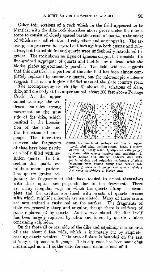
The accompanying sketch (fig. 3) shows the relations of slate, dike, and ore body at the upper tunnel, about 100 feet above Portage Creek. At the uppertunnel workings the evi dence indicates strong movement on. the west side of the dike, which resulted in the breccia- tion of the slate and the formation of some gouge. The interstices between the fragments FIGURE 3. Sketch, of geologic relations at upper
tunnel, mint mine, looking south. Scale, 1 inch= 20 feet a, Blocky slate; t, slip zone with gouge; c, slate, with quartz veinlets and sulphides; d,, badly altered and silicified andesite dike with quartz veinlets and sulphides; e, breccia of slate fragments with quartz filling that carries sul phides; f, slate with, gouge and quartz veinlets that carry sulphides; g, blocky slate
of slate have been partly or wholly filled with so lution quartz. In thin section this quartz ex hibits a mosaic pattern. The quartz grains ad joining the fragments of slate have tended to orient themselves with their optic' axes perpendicular to the fragments. There are many irregular vugs in which the quartz filling is incom plete and the cavities are lined with crusts of quartz prisms with which sulphide minerals are associated. Many of these crusts are now stained a rusty red on the surface. The fragments of slate are generally sharp and angular, though there is evidence of some replacement by quartz. As has been stated, the dike itself has been largely replaced by silica and is cut by quartz veinlets containing sulphides.
On the foot wall or east side of the dike and adjoining it is an area of slate, about 8 feet wide, which is intimately cut by sulphide- bearing quartz veinlets. This area of slate is bounded on the east side by a slip zone with gouge. This slip zone has been somewhat mineralized as well as the slate for some distance east of it.
92 MINERAL RESOURCES OF ALASKA, 1924
At the place where the original discovery was made, about 230 feet above Portage Creek, on the south side of the narrow ridge where the ore body occurs, a continuation of the mineralized zone is seen. At that place a shallow open cut reveals much the same conditions as those already described, though the exposures are imperfect. Blocky slate on the east adjoins the altered dike, which is here about 10 feet thick, is almost completely silicified, and is cut by quartz veinlets carrying sulphide minerals. West of the dike lies a zone 18 inches wide composed mainly of quartz, which carries some sulphides. This zone is succeeded to the west by about 8 feet of slate carrying more or less vein quartz and sulphides. Still far ther west lies a zone 1 to 3 feet wide composed of slate breccia with quartz and sulphides in the interstices. This breccia lies below a hanging wall of blocky slate that shows only scattered specks of sulphide minerals and little quartz.
THE ORE
The ore samples that are described below were examined in thin section or in polished section under the metallographic microscope and are believed to be typical of the slate-breccia portion of the ore body. Much of the highest-grade silver ore, however, occurs as veinlets of quartz carrying ruby silver which cut either the dike rock or the adjoining slate.
Sample la. Slate breccia from open cut near top of ridge on south side. Fragments of slate cemented by solution quartz. The slate consists mainly of a very fine aggregate of biotite and quartz. The fragments have sharp boundaries with the quartz, and there has been almost no replacement of slate. Veinlets of quartz break across the fragments in places, but, the boundaries of the veinlets are sharp and indicate a filling of cracks rather than replacement. However, locally there has been some replacement of slate by quartz, as in the midst of some areas of slate there are perfectly formed quartz prisms, some as much as 1 millimeter in diameter. It is hardly possible that .cavities of the proper size and shape could have existed prior to the advent of the quartz. Sulphides occur in both quartz and slate. Some sericite accompanied the solution quartz and replaced it along the boundaries between the individual grains.
Sample lb. From same locality as sample la. The replacement of slate by quartz is more apparent in sample Ib, and rounded areas of slate surrounded by quartz are common. The solution quartz in places forms a fan-shaped mosaic around fragments of slate. The quartz contains tiny dark inclusions whose exact nature could

A RUBY SILVER PROSPECT IN ALASKA 93
not be determined. They are transparent and dark-brown and may be rutile.
One veinlet of sulphides crosses the entire section mainly in the slate area. It is bounded on both sides by seams of quartz, the quartz grains being oriented more or less perpendicularly to the sulphide veinlet. The quartz at this place is later than the sulphides.
Ore numerals. The following ore minerals were identified in polished sections:Pyrargyrite (AgsSbSs). Galena (PbS). Miargyrite (Ag SbS2 ). Tennantite (?) (CugAs^Sr). Arsenopyrite (FeAsS). Pyrite (FeSa). Chalcopyrite (CuFeS2 ).
These sulphides are very closely associated with one another and form intergrowths which appear as simple patterns in the polished section. Arsenopyrite and pyrite usually show some crystal outlines and may be a little earlier than the remaining sulphides, which form mutual boundaries owing to simultaneous deposition, indicat ing that they are all of the same age. The boundaries are smooth and rounded, with few prominent projections of one mineral in the other. All the minerals are believed to be hypogene. No oxidized minerals were observed, and there are no microscopic structural features indicative of supergene enrichment.
The sulphide minerals are intimately associated with the vein quartz that cements the breccia, and the evidence is' clear that the quartz and ore minerals were deposited by the same solutions.
Pyrargyrite is the predominating ore mineral present. It is readity identified in the hand specimen and forms dark-reddish crusts and coatings on quartz. No crystals were observed in the material studied microscopically, though a few fine prisms as much as 17 millimeters in length by 12 millimeters in diameter have been found. The laboratory examination which polarized light showed only small individual grains, none more than 0.1 millimeter in diameter. An open-tube test indicates that arsenic is entirely absent or forms only a small percentage of the mineral.
Miargyrite is closely intergrown with pyrargyrite and forms ap proximately 10 per cent of the sulphides present. It is recognized only in the polished section and was identified by microchemical tests, by the color of its powder, which is darker than that of pyrargyrite but lighter than that of polybasite, by its color in reflected light, and by its strong anisotropism. No isolated areas of miargyrite were observed, and it occurs only as small rounded areas in pyrargyrite.
Arsenopyrite occurs for the most part as scattered crystals and small clusters of grains well distributed through the specimen. The total amount of arsenopyrite in the specimens observed is about

94 MINERAL RESOURCES OF ALASKA, 1924
the same as that of pyrargyrite. Although most of the arsenopyrite is disseminated, a veinlet of arsenopyrite entirely traverses one of the polished sections and is an open-space filling. Most of the arsenopyrite occurs in quartz, but a relatively small percentage replaces fragments of slate.
Pyrite is relatively rare and was only observed along the margins of the veinlet of arsenopyrite described in the preceding paragraph. The comparative absence of pyrite is noteworthy and indicates that the ore solutions were poor in sulphur.
Chalcopyrite is found only in microscopic quantities and does not form more than 1 per cent of the total sulphides. On the polished surface it appears as small isolated areas in pyrargyrite.
Galena is almost invariably found adjacent to chalcopyrite but is also found as isolated patches in pyrargyrite. In places it forms well-denned graphic intergrowths with pyrargyrite; elsewhere the two minerals form mutual boundaries. The total amount of galena is about the same as that of chalcopyrite.
Closely associated with the galena and chalcopyrite is a mineral which has a brownish-gray tint in reflected light. The total amount of this mineral is too small to permit positive identification. It is inert to all the chemical reagents used and is apparently isotropic in polarized reflected light, hence presumably isometric. Its prop erties check fairly well with those of tennantite.
SUMMARY
The country rock of the Mint mine is composed of a series of slates into which are intruded one or more dikes of andesite. The dikes apparently follow a zone of shearing. The intrusion was ac companied by extensive brecciation and the introduction of large quantities of silica. Quartz was deposited in and around the frag ments of slate and as veinlets traversing them, and there was more or less replacement of these fragments. Where the replacement was most thorough the rock has a bleached appearance and in the hand specimen is indistinguishable from the andesite dike.
The silica in the open-space fillings has many vugs into which project.small slender prisms of quartz.
The association of silica with the sulphides is very close, and the conclusion is warranted that quartz and sulphides were deposited by the same solutions. Some of the sulphides occur as coatings on the quartz prisms of the vugs, but for the most part they occur as isolated bunches in the midst of quartz. There has been very little replacement of quartz by sulphides or sulphides by quartz.
The sulphides are intergrown in patterns which indicate that they are essentially contemporaneous. There is no evidence that any minerals are due to supergene enrichment, and all are believed to

A RUBY SILVER PROSPECT IN ALASKA 95
owe their origin to hypogene deposition. The area in. which the ore body occurs was overridden, in Pleistocene time, by a great glacier that doubtless eroded away any oxidized zone in this deposit and left only the hypogene unoxidized portion of the lode.
Too little work had been done at the time of visit to determine the size or the value of the ore body. A 40-pound picked sample tested by the Bureau of Mines shows a silver content of 117.90 ounces to the ton. A series of samples taken at the mine by Harry Townsend, of the Bureau of Mines, ranged in value from a trace of gold and 1.20 ounces of silver to 0.14 ounce of gold and 32.2 ounces of silver to the ton.
The mineral association resembles that at the Premier and Mayo mines, Yukon Territory. The sharp boundaries of the fragments of slate and the fine-grained character of the quartz, as well as the presence of numerous vugs, indicate conditions of relatively low temperature and pressure. The mineral association is that of the shallow-seated type and will probably not extend to great depth.
78644° 26 7