Embed Size (px)
Citation preview
Geology and Metal Zoning of the Greens Creek Massive Sulfide Deposit, Southeastern Alaska
By Cliff D. Taylor, Andrew W. West, Kerry G. Lear, Tim E. Hall, and John M. Proffett
Chapter 6 ofGeology, Geochemistry, and Genesis of the Greens Creek Massive Sulfide Deposit, Admiralty Island, Southeastern AlaskaEdited by Cliff D. Taylor and Craig A. Johnson
Professional Paper 1763
U.S. Department of the InteriorU.S. Geological Survey
Contents
Abstract .......................................................................................................................................................125Introduction.................................................................................................................................................125Description of the Wall Rocks .................................................................................................................127
Stratigraphic Footwall ......................................................................................................................127Breccia and Conglomeratic Rocks of the Footwall and Hanging Wall ....................................129Stratigraphic Hanging Wall .............................................................................................................129
Description of the Ores .............................................................................................................................130Geometry of the Ore Zones ......................................................................................................................132
East Orebody......................................................................................................................................132West Orebody ....................................................................................................................................132
Central West .............................................................................................................................1329A ................................................................................................................................................132
Northwest West ................................................................................................................................1335250.............................................................................................................................................133
Southwest Orebody ..........................................................................................................................134200 South ...................................................................................................................................134
Metal Zoning ...............................................................................................................................................135References Cited........................................................................................................................................136
Figures
1. Map of southeastern Alaska showing the location of the Greens Creek mine .............127 2. Geologic cross section through the Lower Southwest ore zone, which lies
at the contact between phyllites of the stratigraphic footwall and argillites of the stratigraphic hanging wall ...........................................................................................127
3. Schematic distribution of ore types within an individual Greens Creek orebody prior to deformation ..................................................................................................................130
4. Photographs of representative samples of Greens Creek ore .........................................131 5. Surface projections of the Greens Creek ore zones ..........................................................133 6. North-looking cross section showing, in black, the East, 9A, 5250,
Lower Southwest, and 224 West Bench ore zones ............................................................134 7. Metal zoning observed in the core of the Central West ore zone ....................................135
AbstractThe Greens Creek deposit is a series of massive sulfide
bodies that lie along the contact between altered mafic-ultra-mafic rocks and stratigraphically overlying Upper Triassic argillites. Both the deposit and its enclosing rocks show the effects of lower greenschist facies metamorphism and mul-tiple episodes of deformation. In the footwall, mafic rocks are enriched in silica and have abundant sericite at the ore con-tact; they become richer in chlorite and carbonate away from ore. Ultramafic rocks in the footwall are either serpentinized or carbonate altered. The hanging-wall argillite is massive or slaty and contains graphite, dolomite, or calcite. Locally, nongraphitic carbonate rocks are present at or near the ore contact. Geologic mapping in the underground workings and examination of drill core have revealed a common stratigraphic sequence in which white ores (less than 50 percent sulfides) give way upward to pyritic massive ores and then base-metal-rich massive ores (both greater than 50 percent sulfides).
The deposit consists of three main orebodies, East, West, and Southwest, that are themselves segmented by faults or attenuated zones that are too thin to mine. The global reserve, for a cutoff grade of zero percent metal, is estimated to be 24.2 million tons with grades of 13.9 weight percent zinc, 5.1 weight percent lead, 19.2 troy ounces per ton silver, and 0.15 troy ounce per ton gold. It is likely that continuing exploration will lead to additional discoveries that will increase the size estimate for the deposit.
Restoration of offsets along the Maki and Klaus faults, the two major ore-displacing faults, suggests that the mineralization was originally a single continuous horizon that was thickest in the Central West ore zone and thinned to the north, east, and south. The Central West zone shows a progression from a cop-per-iron zone against the footwall phyllites, to a zinc zone, to a zinc-lead zone, and finally a silver-polymetallic zone against the hanging-wall argillites. Similar footwall-to-hanging-wall progressions are apparent in the East and Southwest orebod-ies, although these orebodies are not yet completely character-ized, and in some locations the metal progression appears to be different. The absence of mine-scale concentric metal zoning suggests that the Greens Creek deposit may have formed above multiple centers of hydrothermal upwelling, or a broad zone of diffuse upwelling, rather than above a single vent.
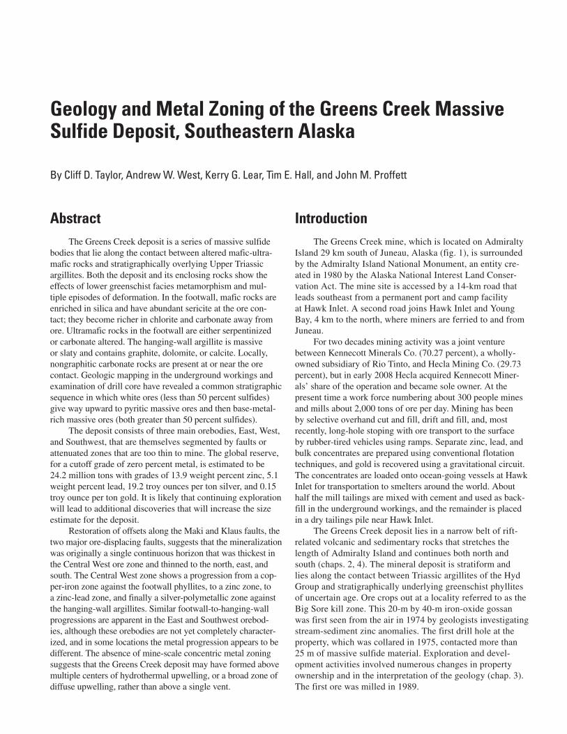
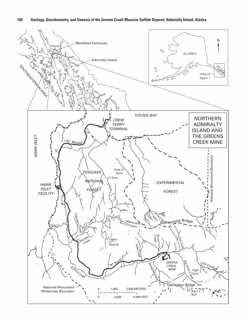
IntroductionThe Greens Creek mine, which is located on Admiralty
Island 29 km south of Juneau, Alaska (fig. 1), is surrounded by the Admiralty Island National Monument, an entity cre-ated in 1980 by the Alaska National Interest Land Conser-vation Act. The mine site is accessed by a 14-km road that leads southeast from a permanent port and camp facility at Hawk Inlet. A second road joins Hawk Inlet and Young Bay, 4 km to the north, where miners are ferried to and from Juneau.
For two decades mining activity was a joint venture between Kennecott Minerals Co. (70.27 percent), a wholly-owned subsidiary of Rio Tinto, and Hecla Mining Co. (29.73 percent), but in early 2008 Hecla acquired Kennecott Miner-als’ share of the operation and became sole owner. At the present time a work force numbering about 300 people mines and mills about 2,000 tons of ore per day. Mining has been by selective overhand cut and fill, drift and fill, and, most recently, long-hole stoping with ore transport to the surface by rubber-tired vehicles using ramps. Separate zinc, lead, and bulk concentrates are prepared using conventional flotation techniques, and gold is recovered using a gravitational circuit. The concentrates are loaded onto ocean-going vessels at Hawk Inlet for transportation to smelters around the world. About half the mill tailings are mixed with cement and used as back-fill in the underground workings, and the remainder is placed in a dry tailings pile near Hawk Inlet.
The Greens Creek deposit lies in a narrow belt of rift-related volcanic and sedimentary rocks that stretches the length of Admiralty Island and continues both north and south (chaps. 2, 4). The mineral deposit is stratiform and lies along the contact between Triassic argillites of the Hyd Group and stratigraphically underlying greenschist phyllites of uncertain age. Ore crops out at a locality referred to as the Big Sore kill zone. This 20-m by 40-m iron-oxide gossan was first seen from the air in 1974 by geologists investigating stream-sediment zinc anomalies. The first drill hole at the property, which was collared in 1975, contacted more than 25 m of massive sulfide material. Exploration and devel-opment activities involved numerous changes in property ownership and in the interpretation of the geology (chap. 3). The first ore was milled in 1989.
Geology and Metal Zoning of the Greens Creek Massive Sulfide Deposit, Southeastern Alaska
By Cliff D. Taylor, Andrew W. West, Kerry G. Lear, Tim E. Hall, and John M. Proffett
126 Geology, Geochemistry, and Genesis of the Greens Creek Massive Sulfide Deposit, Admiralty Island, Alaska
SOUTHEASTERN ALASKA
Mansfield Peninsula
Admiralty Island
Juneau
f .
- .
.
Killer Creek
Bru
inC
reek
Cub Creek
Gallagher Creek
Big S
ore Creek
Cliff CreekGreens Creek
CREWFERRY
TERMINAL
HAWKINLET
FACILITY
"A" Road
"B" Road
Tributary Creek
Mammoth Claim
EXPERIMENTAL
FOREST
BigBoil
NORTHERNADMIRALTY
ISLAND AND THE GREENSCREEK MINE
YOUNG BAY
HA
WK
INLE
T
Mariposite Ridge
TONGASS
NATIONAL
FOREST
Gallagher Ridge
Lil Sore
East LilSore
Nat
ion
al M
on
um
ent
Bo
un
dar
y
Lakes
District
HighSore
0 4,000 8,000 FEET
0 1,000 2,000 METERS
N
Area offigure 1
ALASKA
GREENS CREEK MINE
National MonumentWilderness Boundary
Zinc
Cre
ek
Cascade
Creek
Description of the Wall Rocks 127
The purpose of this chapter is to describe the ores and their immediate wall rocks. The lithologic descriptions are based on core logging, underground and surface mapping, and limited petrographic studies that were carried out by a number of different geologists over a number of years. Information is also given on the geometry of the ore zones and on the metal zoning within them. Much of the information was first docu-mented in reports to the Kennecott Greens Creek Mining Com-pany or its antecedents. The structural geology referred to in this paper is described in detail in chapter 7. For more complete descriptions of the mineralogy and mineral chemistry of the ores, the reader is referred to chapter 9.
Description of the Wall Rocks
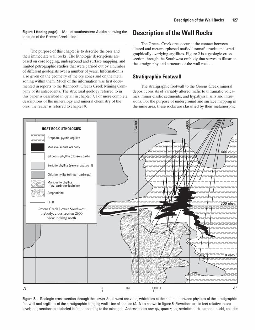
The Greens Creek ores occur at the contact between altered and metamorphosed mafic/ultramafic rocks and strati-graphically overlying argillites. Figure 2 is a geologic cross section through the Southwest orebody that serves to illustrate the stratigraphy and structure of the wall rocks.
Stratigraphic Footwall
The stratigraphic footwall to the Greens Creek mineral deposit consists of variably altered mafic to ultramafic volca-nics, minor clastic sediments, and hypabyssal sills and intru-sions. For the purpose of underground and surface mapping in the mine area, these rocks are classified by their metamorphic
Figure 1 (facing page). Map of southeastern Alaska showing the location of the Greens Creek mine.
LS43
00
LS46
00
A A‘0 150 300 FEET
Greens Creek Lower Southwestorebody, cross section 2600
view looking north
HOST ROCK LITHOLOGIES
Graphitic, pyritic argillite
Massive sulfide orebody
Siliceous phyllite (qtz-ser±carb)
Sericite phyllite (ser-carb±qtz-chl)
Chlorite hyllite (chl-ser-carb±qtz)
Mariposite phyllite (qtz-carb-ser-fuchsite)
Serpentinite
Fault
600 elev.
0 elev.
300 elev.
Figure 2. Geologic cross section through the Lower Southwest ore zone, which lies at the contact between phyllites of the stratigraphic footwall and argillites of the stratigraphic hanging wall. Line of section (A–A’) is shown in figure 5. Elevations are in feet relative to sea level; long sections are labeled in feet according to the mine grid. Abbreviations are: qtz, quartz; ser, sericite; carb, carbonate; chl, chlorite.
128 Geology, Geochemistry, and Genesis of the Greens Creek Massive Sulfide Deposit, Admiralty Island, Alaska
or alteration mineralogy. The mafic lithologies are subdivided into siliceous phyllite, which typically occurs adjacent to ore, sericite phyllite, which is more distal, and chlorite phyl-lite, which is found farthest from ore. Mariposite (chromian phengite) phyllite, which is also believed to have a mafic protolith, is less abundant and less regular in its distribution. The ultramafic lithologies are subdivided into serpentinite and quartz-carbonate-mariposite phyllite, which is believed to be an alteration of serpentinite. Diabase dikes and highly altered gabbros have also been identified, but they are less common.
Siliceous phyllite is white to dark gray and dense and displays a broadly spaced foliation (S2). The rock is composed of cryptocrystalline quartz with minor sericite and medium-grained euhedral pyrite. By definition, siliceous phyllite contains 80 weight percent or more silica. Clasts of angular to rounded quartz or chert are common; these are believed to be tectonic breccias in some locations and sedimentary conglom-erates in others.
The protolith for siliceous phyllite is thought to be a mafic volcanic rock that had been enriched in silica and potassium by metasomatism related to ore formation (see also Newberry and Brew, 1999). However, it is also possible that the protolith was a sediment that had formed prior to ore for-mation from hydrothermal fluids exhaled onto the sea floor.
Sericite phyllite, which is the most abundant footwall lithology, is tan to greenish gray. It is strongly foliated (S2) and commonly displays a crenulation cleavage (S3). Quartz, sericite, and carbonate are the main constituents. The rock can also contain minor chlorite, leucoxene, chromian phengite, serpentine, or graphite. Pyrite is present as disseminations and massive bands, generally increasing in abundance toward ore where it can attain 40 volume percent or more. Sphalerite, galena, and chalcopyrite disseminations are also common (1–3 volume percent). Bands of sphalerite, pyrite, galena, and chalcopyrite occur sporadically, most commonly in the 200 South ore zone where they are interpreted to be feeders for the mineralizing fluids. Remobilized sulfides and remobilized tetrahedrite are present in quartz-carbonate veins adjacent to ore zones.
The original fabrics of the sericite phyllite protolith are no longer evident because they were obliterated by hydro-thermal alteration and metamorphism. Consequently, the unit is subdivided on the basis of alteration mineralogy and is mapped using the modifiers siliceous, graphitic, chloritic, carbonate-rich, and tan (leucoxene). Siliceous sericite phyllite contains quartz-graphite segregations that are believed to rep-resent original quartz-rich sedimentary layers. Where graphite exceeds quartz, the rock is referred to as graphitic. Chloritic sericite phyllite contains 15 volume percent or more chlorite along foliation segregations and grades into chlorite phyllite, a separate unit that is described in a subsequent paragraph. Car-bonate-rich sericite phyllite is composed of massive dolomite or ankerite with minor quartz and sericite. The carbonate-rich lithology was formed by alteration of footwall mafic or ultra-mafic rocks, and it commonly grades into quartz-carbonate-mariposite phyllite or highly sheared rocks of the Upper Shear
Zone (chap. 7). Carbonate-rich sericite phyllite can also occur against the hanging-wall argillites where it is believed to be a replacement of an original debris-flow carbonate rock. Tan sericite phyllite contains 0.5- to 10-cm-thick bands of leucox-ene wisps that, by definition, make up 15 volume percent or more of the rock.
The age of the sericite phyllite is not known. Radiometric methods have yielded Cretaceous dates indicative of meta-morphic resetting (chap. 11). The carbonate-rich and graphitic sericite phyllites, which are thought to have sedimentary protoliths, are not fossiliferous. Duke and others (chap. 4) and Proffett (chap. 7) have proposed a Devonian age based on the identification within both sericite phyllite and siliceous phyl-lite of an early foliation that may correlate with a late Paleo-zoic metamorphic event that has been documented elsewhere on Admiralty Island and on Kupreanof Island (Hauessler and others, 1999).
Chlorite phyllite is medium to dark green and thinly to broadly foliated. The rock contains 60 volume percent or more chlorite in addition to quartz veins and segregations, sericite, carbonate, leucoxene, and magnetite. Far from ore, chlorite phyllite can be massive granular chlorite and calcite. Bull quartz and quartz-carbonate veins are common with thicknesses up to 20 cm. Locally, these veins contain sphal-erite, galena, pyrite, chalcopyrite, and rare silver sulfides and sulfosalts. A subdivision of chlorite phyllite, termed diorite gabbro, is composed of chlorite, relict pyroxene phenocrysts (2–3 mm), and disseminated pyrite (up to 15 volume percent). The presence of phenocrysts indicates that the protolith was a cumulate or intrusive rock.
Mariposite phyllite is a banded to foliated, gray-green to brilliant green rock. It is named for its distinctive green mica, which has been referred to by the varietal names mariposite and fuchsite (for example, Newberry and Brew, 1999; Ander-son and Taylor, 2000) but is most appropriately classified as chromian phengite according to the scheme of Bailey (1984). A survey of representative examples has shown chromium to be characteristically high, reaching 3 weight percent Cr2
O3,
and barium to be occasionally high, reaching 11 weight per-cent BaO (C.D. Taylor, U.S. Geological Survey, unpub. data, 2008). Other minerals are quartz, sericite, carbonate, leucox-ene, and locally chlorite. Mariposite phyllite is found near most of the Greens Creek ore zones (for example, fig. 2), and also where the footwall/hanging-wall contact is unmineralized. Mariposite phyllite is concordant with the mafic stratigraphy and is believed to have had a mafic or ultramafic protolith (see also Newberry and Brew, 1999).
The most abundant ultramafic lithology is serpenti-nite, which is a light to dark green and is typically sheared or crudely foliated. Locally, the rock can be massive. The mineralogy is serpentine, chlorite, carbonate (normally anker-ite), and talc, with minor leucoxene and chromian phengite. Serpentinite is not consistently associated with ore but rather occurs as large masses or irregularly shaped bodies within shear zones, fault zones, or fold noses (for example, fig. 2). It
Description of the Wall Rocks 129
is clear from field observations that considerable strain was localized within this ductile lithology.
Quartz-carbonate-mariposite phyllite, which has not been identified in the cross section shown in figure 2, is massive to crudely foliated and can be white, orange, green, or lavender. The rock is composed of quartz, ankerite, and chromian phen-gite with local occurrences of a lavender phyllosilicate that is believed to be chromian chlorite. In underground exposures this lithology forms massive irregular pods adjacent to serpen-tinite or dolomitic massive argillite. The same lithology out-crops north of the mine on Mammoth Ridge where it has been mapped as green carbonate by Duke and others (chap. 4). The protolith is believed to have been an altered ultramafic rock.
Diabase dikes crosscut both the footwall and the hang-ing wall. They are most common in the southern portion of the mine near the 200 South ore zone. The dikes are medium to dark gray, aphanitic to fine-grained granular, and range from less than 1 centimeter to 1 m in thickness. Plagioclase, pyroxene, and hornblende are phenocrysts. Thicker dikes have well-developed, chilled margins. The dikes are less altered than the surrounding country rock and have not been affected by the D2 deformation that was defined by Proffett (chap. 7). Whether they have been affected by the D3/S3 deformation of Proffett (chap. 7) is uncertain. The dikes are not mineralized themselves, but near ore their emplacement remobilized sulfides, sulfosalts, and rare electrum and native silver along selvages.
Breccia and Conglomeratic Rocks of the Footwall and Hanging Wall
The Greens Creek footwall contains 30-m-thick lenses of dense, white to gray, silicified, quartz+carbonate or chert clasts in a siliceous matrix. The clasts are generally 1–10 cm in diameter, and their mineralogy suggests that they were derived from the underlying phyllites and, less commonly, footwall carbonates. In some locations the clasts are sub-rounded and the rock appears to be a polymict breccia. These occurrences are believed to be debris flows that formed during rifting in Late Triassic time. More commonly, the clasts are subangular and the rock appears to be a monomict breccia. These occurrences, which are typically near silica-altered rocks, are believed to be tectonic breccias that formed by post-ore fracturing of brittle siliceous lithologies. Some tectonic breccias display prominent S2 and S3 foliations; these are mapped separately as foliation breccias.
A third breccia type has been observed underground in the stratigraphic hanging wall. This breccia is polymict and consists of 1–5-cm rounded white quartz and argillite clasts in a matrix of fine-to-coarse subhedral pyrite. Good exposures are found within argillite 20–30 m from ore on the 720 access ramp to the Upper Southwest ore zone (for location see plate 4 in chap. 7). These breccias are thought to be mineralized debris-flow conglomerates.
Beyond indicating depositional environments, the sedi-mentary breccias and conglomerates serve as a marker horizon
for regional stratigraphic correlation. South of Greens Creek, a polymict conglomerate underlies the lower volcanic member of the Hyd Group (chap. 4). This conglomerate is believed to be correlative to the sedimentary breccias and conglomerates at Greens Creek, and to record rifting in the area.
Stratigraphic Hanging Wall
Hanging-wall rocks at Greens Creek are broadly catego-rized as either massive argillite or slaty argillite. Locally, rocks of both categories can approach dolostone. Massive argillite is light gray to black with 1–50-cm-thick beds separated by slaty intervals. Where it is graphite-rich, the rock tends to be finer grained than where it is carbonate-rich. Fractures are com-monly filled with quartz±calcite or quartz±dolomite.
Slaty argillite is light gray to black. This rock exhibits a prominent slaty cleavage (S2) as well as a crenulation cleavage (S3) near fold hinges (F3). Quartz±calcite or quartz±dolomite lightning veins follow and also crosscut foliation planes. Thin-section study reveals that slaty argillite is composed of fine quartz, feldspar, muscovite, and lesser dolomite in a carbo-naceous matrix. The predominance of silicates over dolomite distinguishes this rock unit from massive argillite in which dolomite is more abundant.
Dolomitic massive argillite is characterized by light to medium gray, 1- to 2-m-thick beds of medium to coarse dolomite separated by thin micaceous bands. Graphite is absent. Peloidal textures are common, as are poorly pre-served fossil fragments that include crinoid stems and rare occurrences of the Triassic indicator fossil Halobia. Premo and others (chap. 11) used conodonts from this unit to estab-lish a minimum age for the Greens Creek deposit of latest Carnian/earliest Norian.
Dolomitic massive argillite can grade into carbonate-bearing ore, particularly in the Lower Southwest ore zone. Here, dolomitic massive argillite directly overlies phyllite and forms the footwall to ore. Weakly dolomitized areas are cut by stockwork and gash veins containing pyrite, sphalerite, galena, tetrahedrite, chalcopyrite, white quartz, and white dolomite, suggesting that dolomitization preceded sulfide emplacement. In other ore zones, dolomitic massive argillite can be absent in favor of greater thicknesses of silica rock, which may be a replacement of original carbonate rock.
Dolomitic slaty argillite contains dolomite, quartz, seric-ite, graphite, and coarse pyrite (15 volume percent or more). Discontinuous siliceous lenses, 1 to 25 cm in length, are common. Pyrite can be massive adjacent to the stratigraphic footwall. The occurrence of this lithology adjacent to ore, and its high content of pyrite, both suggest that dolomitization of slaty argillite occurred during sulfide emplacement.
A systematic stratigraphy has not been recognized in the argillites. However, some spatial variations are evident. Seric-ite can be abundant near major faults, and there are indications that sericite increases in abundance upsection. Massive argil-lite is more abundant nearer to the ores, where this lithology can also be enriched in silica. The silica-enriched massive
130 Geology, Geochemistry, and Genesis of the Greens Creek Massive Sulfide Deposit, Admiralty Island, Alaska
argillite grades locally into gray-green or olive-brown chert. The occurrence of precious metals in this chert suggests that the silica enrichment was caused by ore-associated hydro-thermal alteration, but petrographic study has also revealed primary depositional cryptocrystalline quartz chert, which suggests a sedimentary origin for the silica.
Sulfide mineralization in the hanging-wall argillite includes ubiquitous pyrite as fine disseminations, stringers, bands, and framboidal clots. Base-metal sulfides are rare except near ore. Precious metals can be abundant locally (>1 troy ounce per ton gold, >500 troy ounces per ton silver) within meters of ore as microfracture-hosted acanthite, elec-trum, or native silver. This mineralization can be difficult to recognize in hand specimen.
Description of the Ores
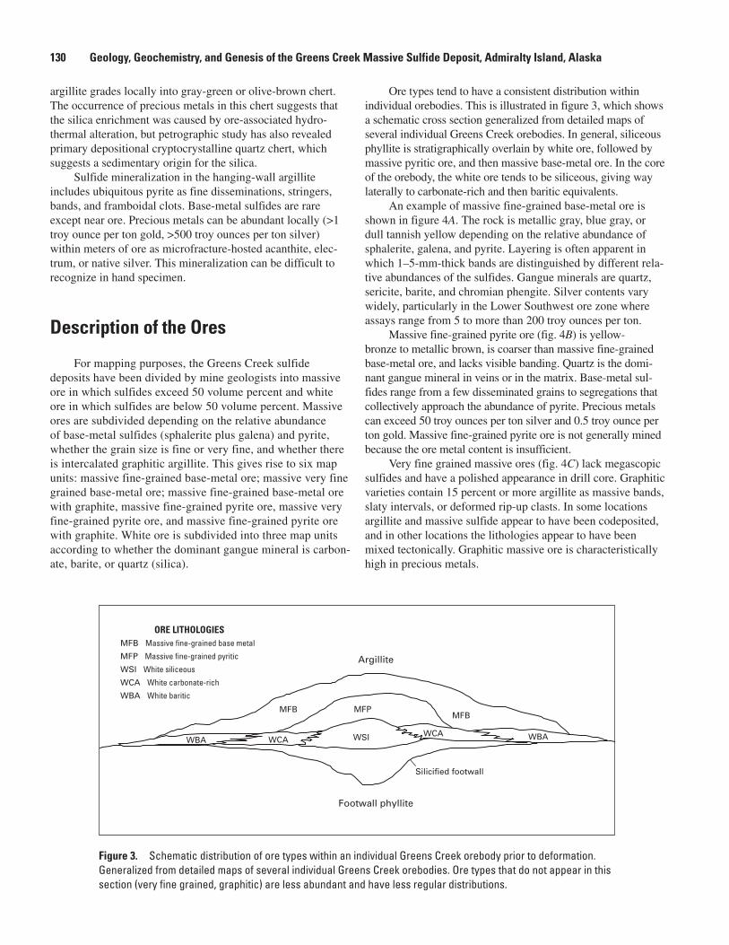
For mapping purposes, the Greens Creek sulfide deposits have been divided by mine geologists into massive ore in which sulfides exceed 50 volume percent and white ore in which sulfides are below 50 volume percent. Massive ores are subdivided depending on the relative abundance of base-metal sulfides (sphalerite plus galena) and pyrite, whether the grain size is fine or very fine, and whether there is intercalated graphitic argillite. This gives rise to six map units: massive fine-grained base-metal ore; massive very fine grained base-metal ore; massive fine-grained base-metal ore with graphite, massive fine-grained pyrite ore, massive very fine-grained pyrite ore, and massive fine-grained pyrite ore with graphite. White ore is subdivided into three map units according to whether the dominant gangue mineral is carbon-ate, barite, or quartz (silica).
Ore types tend to have a consistent distribution within individual orebodies. This is illustrated in figure 3, which shows a schematic cross section generalized from detailed maps of several individual Greens Creek orebodies. In general, siliceous phyllite is stratigraphically overlain by white ore, followed by massive pyritic ore, and then massive base-metal ore. In the core of the orebody, the white ore tends to be siliceous, giving way laterally to carbonate-rich and then baritic equivalents.
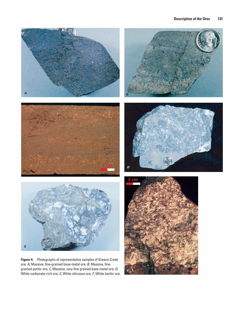
An example of massive fine-grained base-metal ore is shown in figure 4A. The rock is metallic gray, blue gray, or dull tannish yellow depending on the relative abundance of sphalerite, galena, and pyrite. Layering is often apparent in which 1–5-mm-thick bands are distinguished by different rela-tive abundances of the sulfides. Gangue minerals are quartz, sericite, barite, and chromian phengite. Silver contents vary widely, particularly in the Lower Southwest ore zone where assays range from 5 to more than 200 troy ounces per ton.
Massive fine-grained pyrite ore (fig. 4B) is yellow-bronze to metallic brown, is coarser than massive fine-grained base-metal ore, and lacks visible banding. Quartz is the domi-nant gangue mineral in veins or in the matrix. Base-metal sul-fides range from a few disseminated grains to segregations that collectively approach the abundance of pyrite. Precious metals can exceed 50 troy ounces per ton silver and 0.5 troy ounce per ton gold. Massive fine-grained pyrite ore is not generally mined because the ore metal content is insufficient.
Very fine grained massive ores (fig. 4C) lack megascopic sulfides and have a polished appearance in drill core. Graphitic varieties contain 15 percent or more argillite as massive bands, slaty intervals, or deformed rip-up clasts. In some locations argillite and massive sulfide appear to have been codeposited, and in other locations the lithologies appear to have been mixed tectonically. Graphitic massive ore is characteristically high in precious metals.
Argillite
WSIWCAWCA
MFPMFB
MFB
WBA WBA
Silicified footwall
Footwall phyllite
ORE LITHOLOGIESMFB Massive fine-grained base metal
MFP Massive fine-grained pyritic
WSI White siliceous
WCA White carbonate-rich
WBA White baritic
Figure 3. Schematic distribution of ore types within an individual Greens Creek orebody prior to deformation. Generalized from detailed maps of several individual Greens Creek orebodies. Ore types that do not appear in this section (very fine grained, graphitic) are less abundant and have less regular distributions.
Description of the Ores 131
Figure 4. Photographs of representative samples of Greens Creek ore. A, Massive, fine-grained base-metal ore; B, Massive, fine-grained pyritic ore; C, Massive, very fine grained base-metal ore; D, White carbonate-rich ore; E, White siliceous ore; F, White baritic ore.
132 Geology, Geochemistry, and Genesis of the Greens Creek Massive Sulfide Deposit, Admiralty Island, Alaska
Among the white ores the carbonate-rich variety is most abundant. White carbonate ore is massive and white to light gray (fig. 4D). It is composed of granular dolomite with dis-seminated and banded sulfides. Quartz- and carbonate-filled fractures are ubiquitous. White carbonate ore can grade into massive ore, particularly in the West orebody where nearly pure sulfide bands 1 to 50 cm thick are interlayered with carbonate. The sulfide assemblage in these rocks includes pyrite, sphal-erite, galena, bornite, and, locally, chalcopyrite. Argentiferous tetrahedrite is present within quartz-carbonate veins as sub-centimeter blebs. Acanthite, electrum, native silver, and native gold are rare, as are gangue minerals other than carbonate.
White siliceous ore (fig. 4E) is found in all of the known orebodies, although it is usually minor. The silica is domi-nantly cryptocrystalline hydrothermal quartz with lesser vein quartz and chert, but there can also be appreciable carbonate, sericite, chromian phengite, or graphite. The rock is highly variable in texture, sulfide content, and gangue content and can show precious metal grades exceeding 1,000 troy ounces per ton silver and 4 troy ounces per ton gold.
White baritic ore (fig. 4F) is thinly laminated to mas-sive and contains fine sulfides as disseminations or stringers. This lithology is easily identified by its sugary texture and high specific gravity. White baritic ore tends to be base metal sulfide-poor (typically less than 5 volume percent), but silver-rich. Higher grade examples contain disseminated bright red pyrargyrite/proustite. In many locations white baritic ore is too low in metal content to be mined.
Locally, all of the ore types can be veined, brecciated, or crosscut by gouge or rubble zones as a consequence of post-ore faulting or folding. Veining is most common in the white ores. Vein-associated remobilization and recrystallization have resulted in spectacular concentrations of native gold and silver sulfosalts. Good examples are found in the Upper Southwest ore zone where quartz veins contain coarse remobilized sulfides, native gold, electrum, native silver, and argentite/acanthite. Brecciated ores in some cases formed by slumping of massive sulfide, often into weakly mineralized surrounding sediments. In other cases brecciated ores formed by postdepositional faulting and shearing. Solution-collapse breccias have also been identi-fied, particularly in the white carbonate ores.
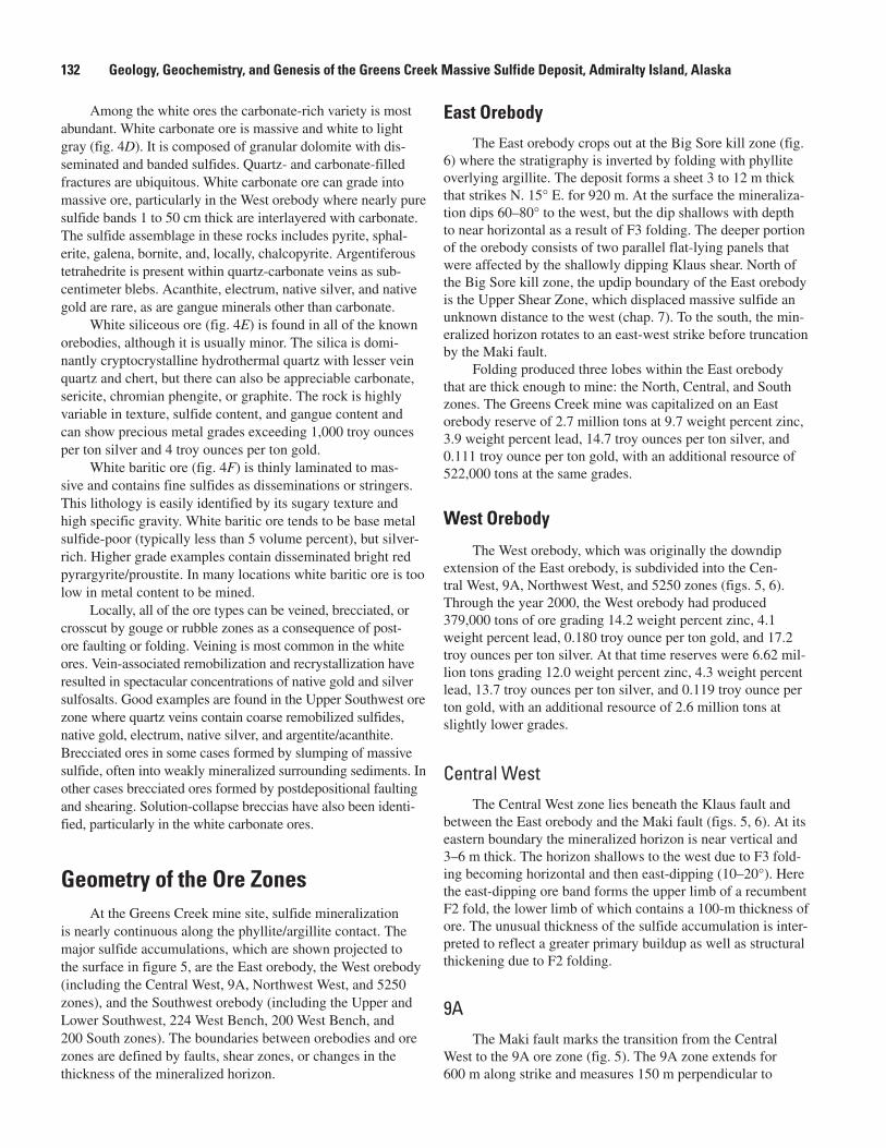
Geometry of the Ore ZonesAt the Greens Creek mine site, sulfide mineralization
is nearly continuous along the phyllite/argillite contact. The major sulfide accumulations, which are shown projected to the surface in figure 5, are the East orebody, the West orebody (including the Central West, 9A, Northwest West, and 5250 zones), and the Southwest orebody (including the Upper and Lower Southwest, 224 West Bench, 200 West Bench, and 200 South zones). The boundaries between orebodies and ore zones are defined by faults, shear zones, or changes in the thickness of the mineralized horizon.
East Orebody
The East orebody crops out at the Big Sore kill zone (fig. 6) where the stratigraphy is inverted by folding with phyllite overlying argillite. The deposit forms a sheet 3 to 12 m thick that strikes N. 15° E. for 920 m. At the surface the mineraliza-tion dips 60–80° to the west, but the dip shallows with depth to near horizontal as a result of F3 folding. The deeper portion of the orebody consists of two parallel flat-lying panels that were affected by the shallowly dipping Klaus shear. North of the Big Sore kill zone, the updip boundary of the East orebody is the Upper Shear Zone, which displaced massive sulfide an unknown distance to the west (chap. 7). To the south, the min-eralized horizon rotates to an east-west strike before truncation by the Maki fault.
Folding produced three lobes within the East orebody that are thick enough to mine: the North, Central, and South zones. The Greens Creek mine was capitalized on an East orebody reserve of 2.7 million tons at 9.7 weight percent zinc, 3.9 weight percent lead, 14.7 troy ounces per ton silver, and 0.111 troy ounce per ton gold, with an additional resource of 522,000 tons at the same grades.
West Orebody
The West orebody, which was originally the downdip extension of the East orebody, is subdivided into the Cen-tral West, 9A, Northwest West, and 5250 zones (figs. 5, 6). Through the year 2000, the West orebody had produced 379,000 tons of ore grading 14.2 weight percent zinc, 4.1 weight percent lead, 0.180 troy ounce per ton gold, and 17.2 troy ounces per ton silver. At that time reserves were 6.62 mil-lion tons grading 12.0 weight percent zinc, 4.3 weight percent lead, 13.7 troy ounces per ton silver, and 0.119 troy ounce per ton gold, with an additional resource of 2.6 million tons at slightly lower grades.
Central West
The Central West zone lies beneath the Klaus fault and between the East orebody and the Maki fault (figs. 5, 6). At its eastern boundary the mineralized horizon is near vertical and 3–6 m thick. The horizon shallows to the west due to F3 fold-ing becoming horizontal and then east-dipping (10–20°). Here the east-dipping ore band forms the upper limb of a recumbent F2 fold, the lower limb of which contains a 100-m thickness of ore. The unusual thickness of the sulfide accumulation is inter-preted to reflect a greater primary buildup as well as structural thickening due to F2 folding.
9A
The Maki fault marks the transition from the Central West to the 9A ore zone (fig. 5). The 9A zone extends for 600 m along strike and measures 150 m perpendicular to
Geometry of the Ore Zones 133
strike. It is composed of numerous fault blocks, all of which display the characteristic stratabound nature of Greens Creek ore. Restoration of the movement along the Maki fault reveals that the 9A zone represents the southwesterly, down-plunge extension of the East orebody and Central West ore zone. Throughout the 9A zone, grain-size reduction during faulting has yielded gouge with millimeter- to centimeter-sized clots of electrum that are rich in gold, silver, and base metals.
Northwest West
The Northwest West zone is an extension of the Central West that was offset along the Maki fault. The structure is dominated by a pair of recumbent F2 folds that form an acute S-shape in cross section, the upper fold an argillite-cored syncline, and the lower fold a phyllite-cored anticline. The
axial planes of these folds were affected by south-southeast-plunging F3 folds (J.M. Proffett, written commun., 1998). The main part of the ore zone lies on the lower limb of the syncline.
5250
The 5250 ore zone is a portion of the East orebody that was offset by the Maki fault (figs. 5, 6). The mineralization continues for 550 m along a north-northwest strike and extends 100 m perpendicular to strike. The intensity of F2 folding increases to the north where the Klaus shear may affect the min-eralization. In the southern portion of the zone, the ore horizon dips more regularly at 60° to 70° to the west and plunges 20° south. The 5250 zone is atypical among the Greens Creek ore zones in containing a high proportion of white baritic ore. This zone is base-metal poor and has not yet been mined.
200South
200 WestBench
South- west
224 WBench
5250
CentralWest
NorthwestWest
9A East
Makifaultzone
0
1,000
2,000
3,000
4,000
5,000
6,00
0
7,00
0
8,00
0
AA’
A‘
0 1,000 FEET
Figure 5. Surface projections of the Greens Creek ore zones. A–A’ is the line of section for figure 2; A–A’ is the line of section for figure 6.
134 Geology, Geochemistry, and Genesis of the Greens Creek Massive Sulfide Deposit, Admiralty Island, Alaska
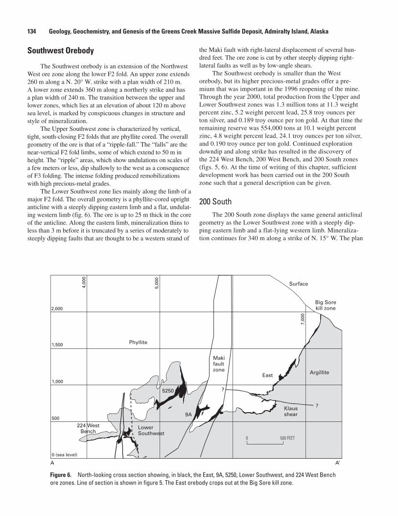
Southwest Orebody
The Southwest orebody is an extension of the Northwest West ore zone along the lower F2 fold. An upper zone extends 260 m along a N. 20° W. strike with a plan width of 210 m. A lower zone extends 360 m along a northerly strike and has a plan width of 240 m. The transition between the upper and lower zones, which lies at an elevation of about 120 m above sea level, is marked by conspicuous changes in structure and style of mineralization.
The Upper Southwest zone is characterized by vertical, tight, south-closing F2 folds that are phyllite cored. The overall geometry of the ore is that of a “ripple-fall.” The “falls” are the near-vertical F2 fold limbs, some of which extend to 50 m in height. The “ripple” areas, which show undulations on scales of a few meters or less, dip shallowly to the west as a consequence of F3 folding. The intense folding produced remobilizations with high precious-metal grades.
The Lower Southwest zone lies mainly along the limb of a major F2 fold. The overall geometry is a phyllite-cored upright anticline with a steeply dipping eastern limb and a flat, undulat-ing western limb (fig. 6). The ore is up to 25 m thick in the core of the anticline. Along the eastern limb, mineralization thins to less than 3 m before it is truncated by a series of moderately to steeply dipping faults that are thought to be a western strand of
the Maki fault with right-lateral displacement of several hun-dred feet. The ore zone is cut by other steeply dipping right-lateral faults as well as by low-angle shears.
The Southwest orebody is smaller than the West orebody, but its higher precious-metal grades offer a pre-mium that was important in the 1996 reopening of the mine. Through the year 2000, total production from the Upper and Lower Southwest zones was 1.3 million tons at 11.3 weight percent zinc, 5.2 weight percent lead, 25.8 troy ounces per ton silver, and 0.189 troy ounce per ton gold. At that time the remaining reserve was 554,000 tons at 10.1 weight percent zinc, 4.8 weight percent lead, 24.1 troy ounces per ton silver, and 0.190 troy ounce per ton gold. Continued exploration downdip and along strike has resulted in the discovery of the 224 West Bench, 200 West Bench, and 200 South zones (figs. 5, 6). At the time of writing of this chapter, sufficient development work has been carried out in the 200 South zone such that a general description can be given.
200 SouthThe 200 South zone displays the same general anticlinal
geometry as the Lower Southwest zone with a steeply dip-ping eastern limb and a flat-lying western limb. Mineraliza-tion continues for 340 m along a strike of N. 15° W. The plan
Klausshear
?
?
Surface
5250
LowerSouthwest
East
Makifaultzone Argillite
Phyllite
9A
0 (sea level)
Big Sorekill zone
500
1,000
1,500
2,000
4,00
0
5,00
0
7,00
0
224 WestBench
A A’
0 500 FEET
Figure 6. North-looking cross section showing, in black, the East, 9A, 5250, Lower Southwest, and 224 West Bench ore zones. Line of section is shown in figure 5. The East orebody crops out at the Big Sore kill zone.
Metal Zoning 135
width is 60 m with an additional 140 m westward extension of bench-style mineralization. The mineralized horizon is 45 m thick in the crest of the anticline and tapers downdip and to the south, although the Greens Creek reserve is currently open to the south.
The 200 South zone extends from 160 m below sea level to 65 m above. There appears to be at least one major F2 anticline in the core of the deposit that has been affected by an F3 fold with east-dipping axial plane. Mineralization is bounded on the east by a steep, brittle fault zone (a strand of the Maki fault) that offsets the ore horizon several hundred feet in a dextral sense.
The 200 South extension is atypical in showing the high-est silver grades adjacent to the footwall phyllite. Production through 2000 was 352,000 tons at 14.6 weight percent zinc, 6.0 weight percent lead, 22.2 troy ounces per ton silver, and 0.237 troy ounce per ton gold. At that time the remaining reserve was 1.15 million tons at 12.9 weight percent zinc, 5.2 weight percent lead, 21.0 troy ounces per ton silver, and 0.184 troy ounce per ton gold.
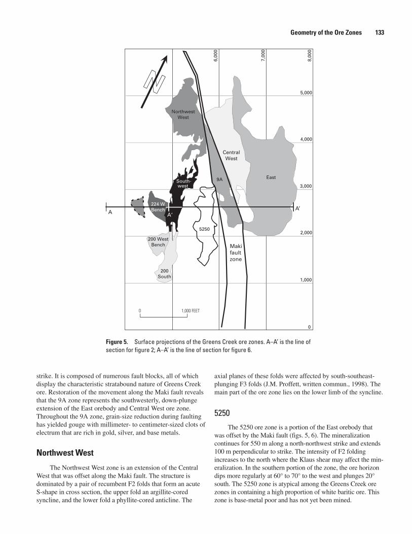
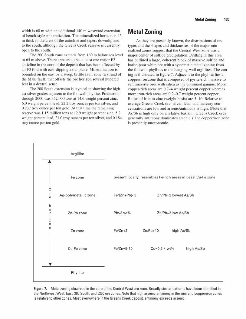
Metal ZoningAs they are presently known, the distributions of ore
types and the shapes and thicknesses of the major min-eralized zones suggest that the Central West zone was a major center of sulfide precipitation. Drilling in this area has outlined a large, coherent block of massive sulfide and barite-poor white ore with a systematic metal zoning from the footwall phyllites to the hanging-wall argillites. The zon-ing is illustrated in figure 7. Adjacent to the phyllite lies a copper/iron zone that is composed of pyrite-rich massive to semimassive ores with silica as the dominant gangue. More copper-rich areas are 0.7–4 weight percent copper whereas more iron-rich areas are 0.2–0.7 weight percent copper. Ratios of iron to zinc (weight basis) are 5–10. Relative to average Greens Creek ore, silver, lead, and mercury con-centrations are low and arsenic/antimony is high. (Note that As/Sb is high only on a relative basis; in Greens Creek ores generally antimony dominates arsenic.) The copper/iron zone is presently uneconomic.
Fe zone
Ag-polymetallic zone
Zn-Pb zone
Zn zone
Cu-Fe zone
Argillite
Phyllite
present locally, resembles Fe-rich areas in basal Cu-Fe zone
Fe/(Zn+Pb)<3 Zn/Pb=2 lowest As/Sb
Pb>3 wt% Zn/Pb=2 low As/Sb
Fe/Zn<2 Zn/Pb>10 high As/Sb
Fe/Zn=5-10 Cu=0.2-4 wt% high As/Sb
Ore
horizon
Figure 7. Metal zoning observed in the core of the Central West ore zone. Broadly similar patterns have been identified in the Northwest West, East, 200 South, and 5250 ore zones. Note that high arsenic:antimony in the zinc and copper/iron zones is relative to other zones. Most everywhere in the Greens Creek deposit, antimony exceeds arsenic.
136 Geology, Geochemistry, and Genesis of the Greens Creek Massive Sulfide Deposit, Admiralty Island, Alaska
Stratigraphically overlying the copper/iron zone is a zinc zone where iron to zinc ratios are less than 2 and zinc to lead ratios are greater than 10. Mercury concentrations are 2–10 times the concentration in the copper/iron zone, and arsenic/antimony is relatively high.
Above the zinc zone is a zinc/lead zone. Here, lead is 3 weight percent or higher, zinc to lead ratios are about 2, and mercury concentrations are 10–15 times the concentrations in the copper/iron zone.
A silver/polymetallic zone typically occurs adjacent to argillite or within the cores of synclines. This zone is charac-terized by Fe/(Zn+Pb) of 3 or less, zinc/lead of 2, relatively high concentrations of arsenic and antimony, and the lowest arsenic/antimony ratios of all the zones. Gold concentrations are slightly elevated.
In some locations, an iron-rich, zinc- and lead-poor zone can be found between the silver/polymetallic zone and the hanging-wall argillite. Metal concentrations resemble those in iron-rich portions of the basal copper/iron zone.
Restoration of the displacement along the Maki fault places the high-copper pyritic ores of the Central West ore zone adjacent to copper/iron-rich mineralization of the Northwest West ore zone. Detailed metal zoning studies of the Northwest West have not been carried out, but a cursory inves-tigation indicates a pattern similar to that in the Central West zone, but overlying a thicker sequence of siliceous phyllite in the footwall.
The East orebody (particularly the steeply dipping por-tion of the South zone), the 200 South zone, and the 5250 zone show metal zoning patterns similar to the Central West and Northwest West zones. However, the understanding of metal distributions in these locations is incomplete, and locally the zoning can differ from the Central West. As it is presently understood, the overall Greens Creek metal distributions do not show the concentric zoning pattern that would be expected if the sulfide mineralization formed above a single hydro-thermal center. Thus, despite the fact that the ore horizon thins away from the Central West ore zone as if this were the principal vent for the metalliferous fluids, the metal zoning patterns suggest instead that hydrothermal upwelling was from multiple centers or was diffuse across a broad area.
References Cited
Anderson, V.M., and Taylor, C.D., 2000, Alteration mineral-ogy and zonation in host rocks to the Greens Creek deposit, southeastern Alaska [abs.]: Geological Society of America Abstracts with Programs, v. 32, p. A–2.
Bailey, S.W., 1984, Classification and structure of the micas: Reviews in Mineralogy, v. 13, p. 1–12.
Haeussler, P.J., Karl, S.M., Mortensen, J.K., Layer, Paul, and Himmelberg, G.R., 1999, Permian and mid-Cretaceous deformation of the Alexander terrane on Admiralty and Kupreanof Islands, southeastern Alaska [abs.]: Geological Society of America Abstracts with Programs v. 31, p. A–60.
Newberry, R.J., and Brew, D.A., 1999, Chemical and isotopic data for rocks and ores from the Upper Triassic Greens Creek and Woewodski Island volcanogenic massive sul-fide deposits, southeastern Alaska, in Kelley, K.D., ed., Geologic studies in Alaska by the U.S. Geological Survey, 1997: U.S. Geological Survey Professional Paper 1614, p. 35–55.


![THE ECONOMICS OF EXCLUSIONARY ZONING … collapse of the U.S. housing bubble has led to a massive oversupply of housing, ... 2009] Economics of Exclusionary Zoning and Affordable Housing](https://img.pdfslide.us/doc/110x75/5ad867f27f8b9a98098e020c/the-economics-of-exclusionary-zoning-collapse-of-the-us-housing-bubble-has.jpg)