Embed Size (px)
Citation preview
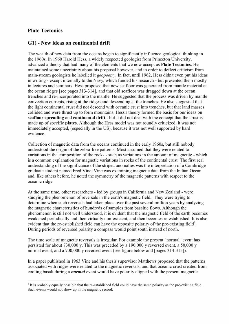
Plate Tectonics
G1) - New ideas on continental drift
The wealth of new data from the oceans began to significantly influence geological thinking in
the 1960s. In 1960 Harold Hess, a widely respected geologist from Princeton University,
advanced a theory that had many of the elements that we now accept as Plate Tectonics. He
maintained some uncertainty about his proposal however, and in order to deflect criticism from
main-stream geologists he labelled it geopoetry. In fact, until 1962, Hess didn't even put his ideas
in writing - except internally to the Navy, which funded his research - but presented them mostly
in lectures and seminars. Hess proposed that new seafloor was generated from mantle material at
the ocean ridges [see pages 313-314], and that old seafloor was dragged down at the ocean
trenches and re-incorporated into the mantle. He suggested that the process was driven by mantle
convection currents, rising at the ridges and descending at the trenches. He also suggested that
the light continental crust did not descend with oceanic crust into trenches, but that land masses
collided and were thrust up to form mountains. Hess's theory formed the basis for our ideas on
seafloor spreading and continental drift - but it did not deal with the concept that the crust is
made up of specific plates. Although the Hess model was not roundly criticized, it was not
immediately accepted, (especially in the US), because it was not well supported by hard
evidence.
Collection of magnetic data from the oceans continued in the early 1960s, but still nobody
understood the origin of the zebra-like patterns. Most assumed that they were related to
variations in the composition of the rocks - such as variations in the amount of magnetite - which
is a common explanation for magnetic variations in rocks of the continental crust. The first real
understanding of the significance of the striped anomalies was the interpretation of a Cambridge
graduate student named Fred Vine. Vine was examining magnetic data from the Indian Ocean
and, like others before, he noted the symmetry of the magnetic patterns with respect to the
oceanic ridge.
At the same time, other researchers - led by groups in California and New Zealand - were
studying the phenomenon of reversals in the earth's magnetic field. They were trying to
determine when such reversals had taken place over the past several million years by analyzing
the magnetic characteristics of hundreds of samples from basaltic flows. Although the
phenomenon is still not well understood, it is evident that the magnetic field of the earth becomes
weakened periodically and then virtually non-existent, and then becomes re-established. It is also
evident that the re-established field can have the opposite polarity of the pre-existing field1.
During periods of reversed polarity a compass would point south instead of north.
The time scale of magnetic reversals is irregular. For example the present "normal" event has
persisted for about 730,000 y. This was preceded by a 190,000 y reversed event, a 50,000 y
normal event, and a 700,000 y reversed event (see figure below and [pages 314-315]).
In a paper published in 1963 Vine and his thesis supervisor Matthews proposed that the patterns
associated with ridges were related to the magnetic reversals, and that oceanic crust created from
cooling basalt during a normal event would have polarity aligned with the present magnetic
1 It is probably equally possible that the re-established field could have the same polarity as the pre-existing field.
Such events would not show up in the magnetic record.
Vancouver Island University • Geology 111 • Discovering Planet Earth • Steven Earle • 2010
2
field, and thus would produce a positive anomaly (a black stripe on the sea-floor magnetic map),
whereas oceanic crust created during a reversed event would have polarity opposite to the
present field and thus would produce a negative magnetic anomaly (a white stripe). The same
general idea was also put forward at about the same time by a Geological Survey of Canada geologist
Lawrence Morley. Many people refer to the idea as the Vine-Matthews-Morely hypothesis.
Vine, Matthews and Morely (VMM) were the first to show this type of correspondence between
the relative widths of the stripes and the periods of the magnetic reversals. The VMM hypothesis
was confirmed within a few years when magnetic data were compiled from spreading ridges
around the world. It was shown that the same general magnetic patterns were present straddling
each ridge, although the widths of the anomalies varied according to the spreading rates
characteristic of the different ridges. It was also shown that the patterns corresponded with the
chronology of the earth's magnetic field reversals. This global consistency provided strong
support for the VMM hypothesis and led to rejection of the other explanations for the magnetic
anomalies.
The magnetic field reversal chronology is shown here in red and white (red = normal, white = reversed). Part of the magnetic pattern of the Juan de Fuca ridge is shown in black. See if you can correlate
some of the magnetic reversal patterns on either side of the ridge crest with the reversal chronology.
[There is more information on this topic on pages 315-316 of the text.]
Vancouver Island University • Geology 111 • Discovering Planet Earth • Steven Earle • 2010
3
G2) Mantle plumes, transform faults and plate tectonics
Mantle plumes
In 1963, J. Tuzo Wilson of the University of Toronto proposed the idea of a mantle plume or
hot spot - a place where hot mantle material rises in a semi-permanent plume, and affects the
overlying crust. He based this hypothesis partly on the distribution of the Hawaiian and Emperor
Seamount island chains in the Pacific Ocean [Fig. 12.19]. The volcanic rock making up these
islands gets progressively younger towards the southeast, culminating with the island of Hawaii
itself, which is all less than 1 m.y. old, and in part is much younger. Wilson suggested that a
stationary plume of hot upwelling mantle material is the source of the Hawaiian volcanism, and
that the ocean crust of the Pacific Plate is moving towards the northwest over this hot spot. Near
to the Midway Islands the chain takes a pronounced change in direction, from northwest-
southeast for the Hawaiian Islands, to nearly north-south for the Emperor Seamounts. This
change is ascribed to a change in direction of the Pacific plate moving over the stationary hot
spot - a change which took place about 40 m.y. ago.
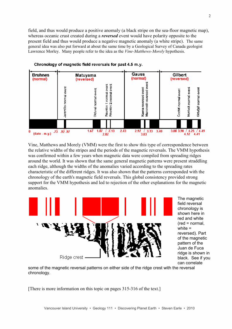
There is evidence of many such hot-spots around the world (see map below). Most are within the
ocean basins - including places like Iceland and the Galapagos Islands - but some are under
continents - an example being the Yellowstone hot spot in the west-central United States, and the
hot-spot responsible for the Anahim Volcanic Belt in central British Columbia (west of Quesnel).
It is suggested that mantle plumes are very long-lived phenomena, lasting for at least tens of
millions of years, probably for hundreds of millions of years. It is also evident that they are
typically stationary features with respect to the mantle and core of the earth - while the crust
overhead is always moving.
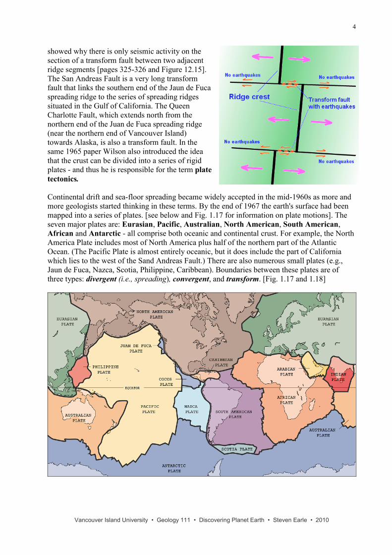
Transform faults
Although oceanic spreading ridges appear to be curved features on the earth's surface, in fact the
ridges are composed of a series of straight-line segments, offset at intervals by faults
perpendicular to the ridge (see figure to the right). In a paper published in 1965 Tuzo Wilson
termed these features transform faults. He described the nature of the motion along them, and
Vancouver Island University • Geology 111 • Discovering Planet Earth • Steven Earle • 2010
4
showed why there is only seismic activity on the
section of a transform fault between two adjacent
ridge segments [pages 325-326 and Figure 12.15].
The San Andreas Fault is a very long transform
fault that links the southern end of the Jaun de Fuca
spreading ridge to the series of spreading ridges
situated in the Gulf of California. The Queen
Charlotte Fault, which extends north from the
northern end of the Juan de Fuca spreading ridge
(near the northern end of Vancouver Island)
towards Alaska, is also a transform fault. In the
same 1965 paper Wilson also introduced the idea
that the crust can be divided into a series of rigid
plates - and thus he is responsible for the term plate
tectonics.
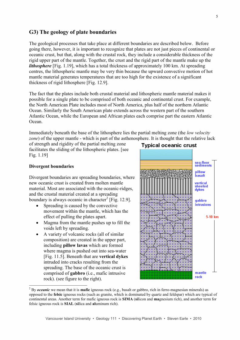
Continental drift and sea-floor spreading became widely accepted in the mid-1960s as more and
more geologists started thinking in these terms. By the end of 1967 the earth's surface had been
mapped into a series of plates. [see below and Fig. 1.17 for information on plate motions]. The
seven major plates are: Eurasian, Pacific, Australian, North American, South American,
African and Antarctic - all comprise both oceanic and continental crust. For example, the North
America Plate includes most of North America plus half of the northern part of the Atlantic
Ocean. (The Pacific Plate is almost entirely oceanic, but it does include the part of California
which lies to the west of the Sand Andreas Fault.) There are also numerous small plates (e.g.,
Jaun de Fuca, Nazca, Scotia, Philippine, Caribbean). Boundaries between these plates are of
three types: divergent (i.e., spreading), convergent, and transform. [Fig. 1.17 and 1.18]
Vancouver Island University • Geology 111 • Discovering Planet Earth • Steven Earle • 2010
5
G3) The geology of plate boundaries
The geological processes that take place at different boundaries are described below. Before
going there, however, it is important to recognize that plates are not just pieces of continental or
oceanic crust, but that, along with the crustal rock, they include a considerable thickness of the
rigid upper part of the mantle. Together, the crust and the rigid part of the mantle make up the
lithosphere [Fig. 1.19], which has a total thickness of approximately 100 km. At spreading
centres, the lithospheric mantle may be very thin because the upward convective motion of hot
mantle material generates temperatures that are too high for the existence of a significant
thickness of rigid lithosphere [Fig. 12.9].
The fact that the plates include both crustal material and lithospheric mantle material makes it
possible for a single plate to be comprised of both oceanic and continental crust. For example,
the North American Plate includes most of North America, plus half of the northern Atlantic
Ocean. Similarly the South American plate extends across the western part of the southern
Atlantic Ocean, while the European and African plates each comprise part the eastern Atlantic
Ocean.
Immediately beneath the base of the lithosphere lies the partial melting zone (the low velocity
zone) of the upper mantle - which is part of the asthenosphere. It is thought that the relative lack
of strength and rigidity of the partial melting zone
facilitates the sliding of the lithospheric plates. [see
Fig. 1.19]
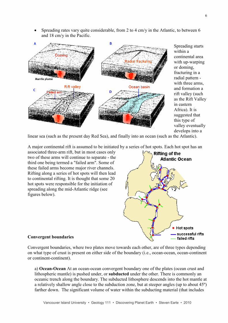
Divergent boundaries
Divergent boundaries are spreading boundaries, where
new oceanic crust is created from molten mantle
material. Most are associated with the oceanic-ridges,
and the crustal material created at a spreading
boundary is always oceanic in character2 [Fig. 12.9].
Spreading is caused by the convective
movement within the mantle, which has the
effect of pulling the plates apart.
Magma from the mantle pushes up to fill the
voids left by spreading.
A variety of volcanic rocks (all of similar
composition) are created in the upper part,
including pillow lavas which are formed
where magma is pushed out into sea-water
[Fig. 11.5]. Beneath that are vertical dykes
intruded into cracks resulting from the
spreading. The base of the oceanic crust is
comprised of gabbro (i.e., mafic intrusive
rock). (see figure to the right).
2 By oceanic we mean that it is mafic igneous rock (e.g., basalt or gabbro, rich in ferro-magnesian minerals) as
opposed to the felsic igneous rocks (such as granite, which is dominated by quartz and feldspar) which are typical of
continental areas. Another term for mafic igneous rock is SIMA (silicon and magnesium rich), and another term for
felsic igneous rock is SIAL (silica and aluminum rich).
Vancouver Island University • Geology 111 • Discovering Planet Earth • Steven Earle • 2010
6
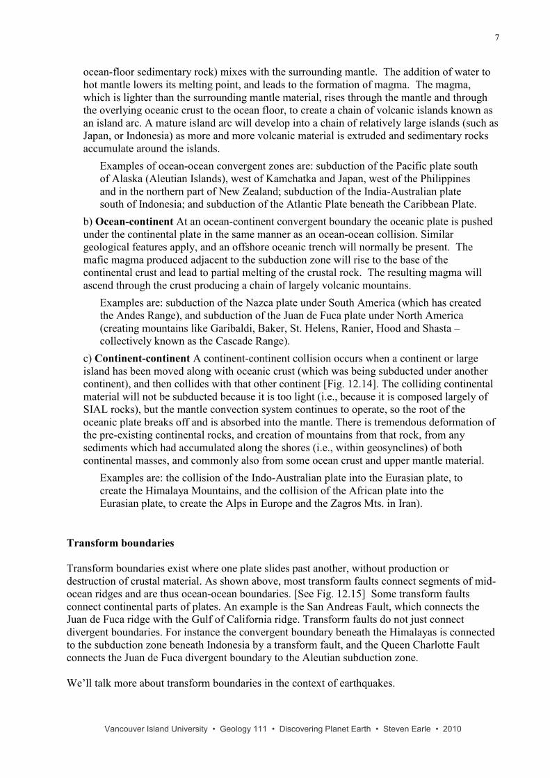
Spreading rates vary quite considerable, from 2 to 4 cm/y in the Atlantic, to between 6
and 18 cm/y in the Pacific.
Spreading starts
within a
continental area
with up-warping
or doming,
fracturing in a
radial pattern -
with three arms,
and formation a
rift valley (such
as the Rift Valley
in eastern
Africa). It is
suggested that
this type of
valley eventually
develops into a
linear sea (such as the present day Red Sea), and finally into an ocean (such as the Atlantic).
A major continental rift is assumed to be initiated by a series of hot spots. Each hot spot has an
associated three-arm rift, but in most cases only
two of these arms will continue to separate - the
third one being termed a "failed arm". Some of
these failed arms become major river channels.
Rifting along a series of hot spots will then lead
to continental rifting. It is thought that some 20
hot spots were responsible for the initiation of
spreading along the mid-Atlantic ridge (see
figures below).
Convergent boundaries
Convergent boundaries, where two plates move towards each other, are of three types depending
on what type of crust is present on either side of the boundary (i.e., ocean-ocean, ocean-continent
or continent-continent).
a) Ocean-Ocean At an ocean-ocean convergent boundary one of the plates (ocean crust and
lithospheric mantle) is pushed under, or subducted under the other. There is commonly an
oceanic trench along the boundary. The subducted lithosphere descends into the hot mantle at
a relatively shallow angle close to the subduction zone, but at steeper angles (up to about 45º)
farther down. The significant volume of water within the subducting material (that includes
Vancouver Island University • Geology 111 • Discovering Planet Earth • Steven Earle • 2010
7
ocean-floor sedimentary rock) mixes with the surrounding mantle. The addition of water to
hot mantle lowers its melting point, and leads to the formation of magma. The magma,
which is lighter than the surrounding mantle material, rises through the mantle and through
the overlying oceanic crust to the ocean floor, to create a chain of volcanic islands known as
an island arc. A mature island arc will develop into a chain of relatively large islands (such as
Japan, or Indonesia) as more and more volcanic material is extruded and sedimentary rocks
accumulate around the islands.
Examples of ocean-ocean convergent zones are: subduction of the Pacific plate south
of Alaska (Aleutian Islands), west of Kamchatka and Japan, west of the Philippines
and in the northern part of New Zealand; subduction of the India-Australian plate
south of Indonesia; and subduction of the Atlantic Plate beneath the Caribbean Plate.
b) Ocean-continent At an ocean-continent convergent boundary the oceanic plate is pushed
under the continental plate in the same manner as an ocean-ocean collision. Similar
geological features apply, and an offshore oceanic trench will normally be present. The
mafic magma produced adjacent to the subduction zone will rise to the base of the
continental crust and lead to partial melting of the crustal rock. The resulting magma will
ascend through the crust producing a chain of largely volcanic mountains.
Examples are: subduction of the Nazca plate under South America (which has created
the Andes Range), and subduction of the Juan de Fuca plate under North America
(creating mountains like Garibaldi, Baker, St. Helens, Ranier, Hood and Shasta –
collectively known as the Cascade Range).
c) Continent-continent A continent-continent collision occurs when a continent or large
island has been moved along with oceanic crust (which was being subducted under another
continent), and then collides with that other continent [Fig. 12.14]. The colliding continental
material will not be subducted because it is too light (i.e., because it is composed largely of
SIAL rocks), but the mantle convection system continues to operate, so the root of the
oceanic plate breaks off and is absorbed into the mantle. There is tremendous deformation of
the pre-existing continental rocks, and creation of mountains from that rock, from any
sediments which had accumulated along the shores (i.e., within geosynclines) of both
continental masses, and commonly also from some ocean crust and upper mantle material.
Examples are: the collision of the Indo-Australian plate into the Eurasian plate, to
create the Himalaya Mountains, and the collision of the African plate into the
Eurasian plate, to create the Alps in Europe and the Zagros Mts. in Iran).
Transform boundaries
Transform boundaries exist where one plate slides past another, without production or
destruction of crustal material. As shown above, most transform faults connect segments of mid-
ocean ridges and are thus ocean-ocean boundaries. [See Fig. 12.15] Some transform faults
connect continental parts of plates. An example is the San Andreas Fault, which connects the
Juan de Fuca ridge with the Gulf of California ridge. Transform faults do not just connect
divergent boundaries. For instance the convergent boundary beneath the Himalayas is connected
to the subduction zone beneath Indonesia by a transform fault, and the Queen Charlotte Fault
connects the Juan de Fuca divergent boundary to the Aleutian subduction zone.
We’ll talk more about transform boundaries in the context of earthquakes.
Vancouver Island University • Geology 111 • Discovering Planet Earth • Steven Earle • 2010
8
G4) The break-up of Pangea and the Wilson cycle
As originally proposed by Wegener in 1915, the present continents were once all part of a super-
continent which he termed Pangea (all land). More recent studies of continental match-ups and
the ages of ocean-floor rocks have enabled us to reconstruct the history of the break-up of
Pangea.
Pangea began to break up along a line between Africa and Asia and between North America and
South America between 250 and 200 m.y. ago. During the same period the Atlantic ocean began
to open up between northern Africa and North America, and India broke away from Antarctica.
[see pages 318-319]
Between 200 and 150 m.y. ago rifting started between South America and Africa and between
North America and Europe, and India was moving north towards Asia. By 65 m.y. ago Africa
had separated from South America, and most of Europe had separated from North America. A
rift began to develop between Australia and Antarctic. India collided into Asia about 45 m.y.
ago.
Within the past few million years rifting has taken place in the Gulf of Aden and the Red Sea,
and within the Gulf of California. Incipient rifting has begun along the great Rift Valley of
eastern Africa, extending from Ethiopia and Djibouti on the Gulf of Aden (Red Sea) all the way
south to Malawi.
Over the next 50 m.y. it is likely that there will be full development of the east African rift and
creation of new ocean floor. Eventually Africa will probably split apart. There will also be
continued northerly movement of Australia and Indonesia. The western part of California
(including Los Angeles and part of San Francisco), will split away from the rest of North
America, and will eventually sail right by Vancouver Island, en route to Alaska! The Atlantic
Ocean is very slowly getting bigger, and the Pacific Ocean is getting smaller - and if this
continues without changing for another couple of hundred million years we will be back to
where we started, with one super-continent.
There is an interesting animation of continental movements at a Berkeley Geology Department
web site. http://www.ucmp.berkeley.edu/geology/tectonics.html.
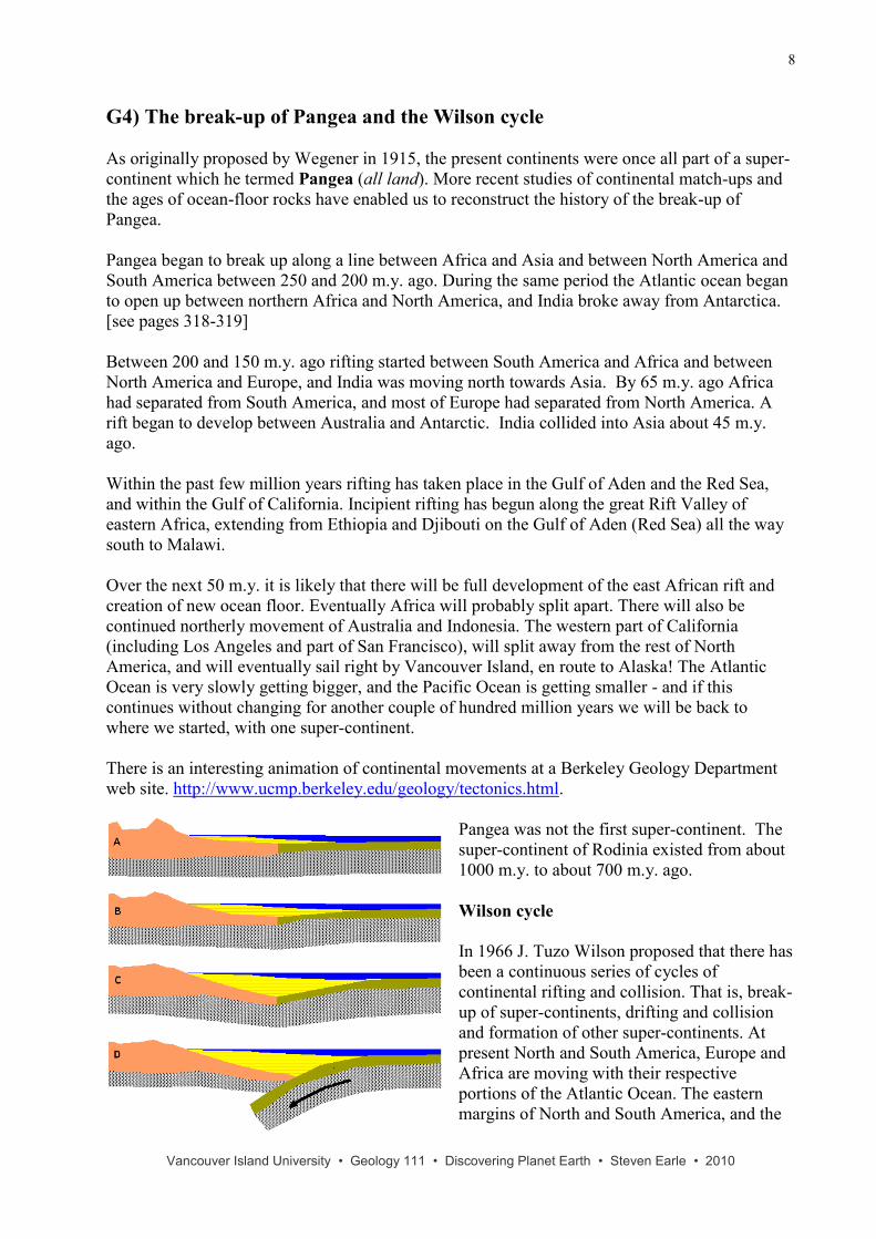
Pangea was not the first super-continent. The
super-continent of Rodinia existed from about
1000 m.y. to about 700 m.y. ago.
Wilson cycle
In 1966 J. Tuzo Wilson proposed that there has
been a continuous series of cycles of
continental rifting and collision. That is, break-
up of super-continents, drifting and collision
and formation of other super-continents. At
present North and South America, Europe and
Africa are moving with their respective
portions of the Atlantic Ocean. The eastern
margins of North and South America, and the
Vancouver Island University • Geology 111 • Discovering Planet Earth • Steven Earle • 2010
9
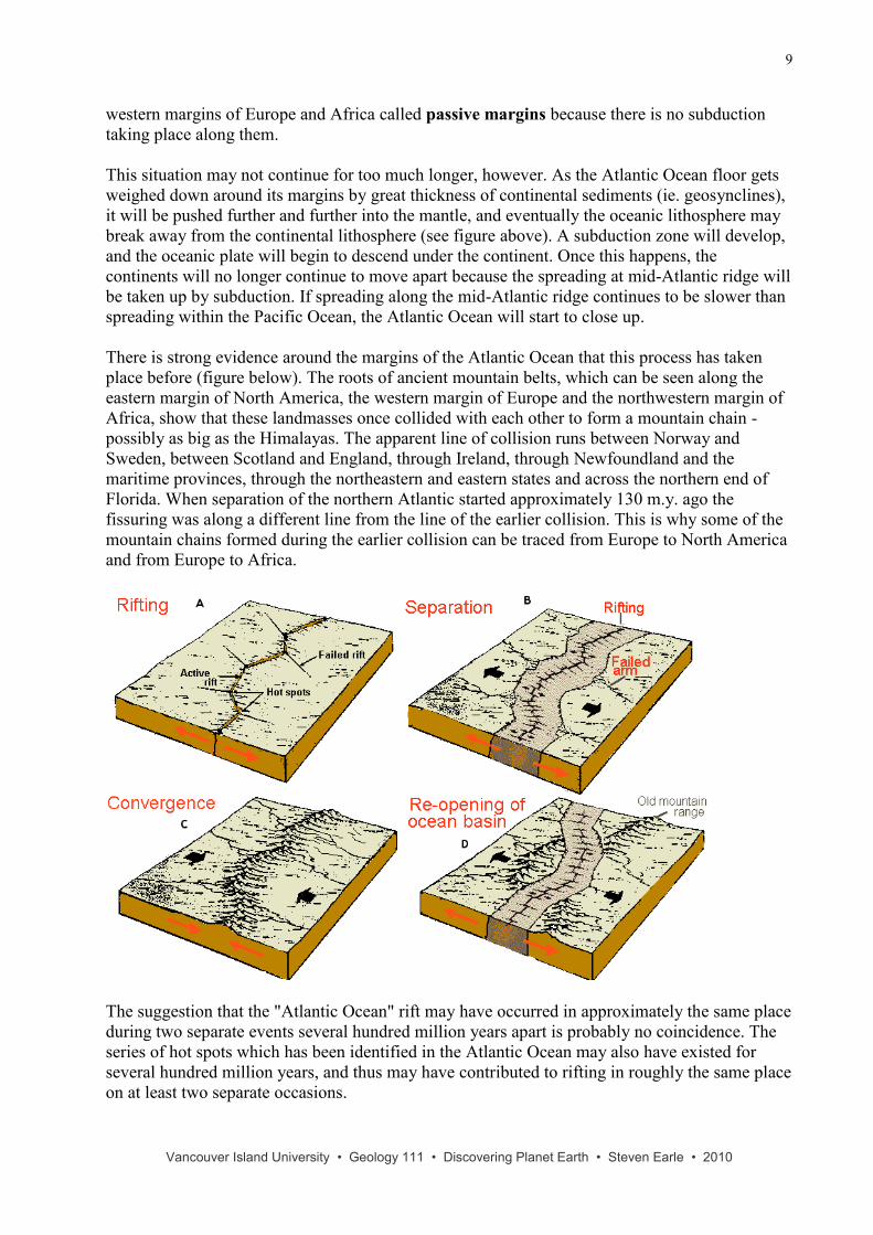
western margins of Europe and Africa called passive margins because there is no subduction
taking place along them.
This situation may not continue for too much longer, however. As the Atlantic Ocean floor gets
weighed down around its margins by great thickness of continental sediments (ie. geosynclines),
it will be pushed further and further into the mantle, and eventually the oceanic lithosphere may
break away from the continental lithosphere (see figure above). A subduction zone will develop,
and the oceanic plate will begin to descend under the continent. Once this happens, the
continents will no longer continue to move apart because the spreading at mid-Atlantic ridge will
be taken up by subduction. If spreading along the mid-Atlantic ridge continues to be slower than
spreading within the Pacific Ocean, the Atlantic Ocean will start to close up.
There is strong evidence around the margins of the Atlantic Ocean that this process has taken
place before (figure below). The roots of ancient mountain belts, which can be seen along the
eastern margin of North America, the western margin of Europe and the northwestern margin of
Africa, show that these landmasses once collided with each other to form a mountain chain -
possibly as big as the Himalayas. The apparent line of collision runs between Norway and
Sweden, between Scotland and England, through Ireland, through Newfoundland and the
maritime provinces, through the northeastern and eastern states and across the northern end of
Florida. When separation of the northern Atlantic started approximately 130 m.y. ago the
fissuring was along a different line from the line of the earlier collision. This is why some of the
mountain chains formed during the earlier collision can be traced from Europe to North America
and from Europe to Africa.
The suggestion that the "Atlantic Ocean" rift may have occurred in approximately the same place
during two separate events several hundred million years apart is probably no coincidence. The
series of hot spots which has been identified in the Atlantic Ocean may also have existed for
several hundred million years, and thus may have contributed to rifting in roughly the same place
on at least two separate occasions.
Vancouver Island University • Geology 111 • Discovering Planet Earth • Steven Earle • 2010
10
G5) Plate tectonics and the geological history of British Columbia
Much of North America is made up of very old rocks. There are large areas of rocks within the
shield of central and northern Canada which are all older than 2.5 b.y. The oldest rocks of the
world - over 4 b.y. old - are found on the eastern shore of Hudson Bay. In contrast, however,
much of British Columbia is relatively young. Up until just a few hundred million years ago
most of the area of this province either didn't exist or was under water.
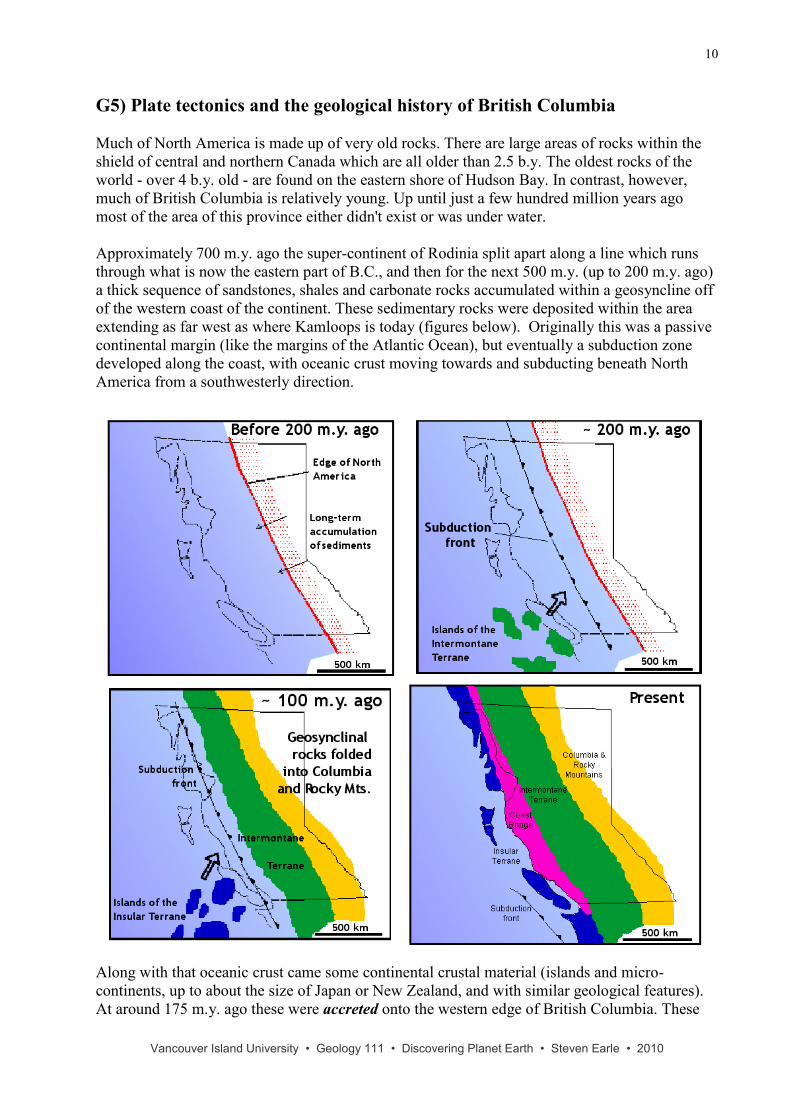
Approximately 700 m.y. ago the super-continent of Rodinia split apart along a line which runs
through what is now the eastern part of B.C., and then for the next 500 m.y. (up to 200 m.y. ago)
a thick sequence of sandstones, shales and carbonate rocks accumulated within a geosyncline off
of the western coast of the continent. These sedimentary rocks were deposited within the area
extending as far west as where Kamloops is today (figures below). Originally this was a passive
continental margin (like the margins of the Atlantic Ocean), but eventually a subduction zone
developed along the coast, with oceanic crust moving towards and subducting beneath North
America from a southwesterly direction.
Along with that oceanic crust came some continental crustal material (islands and micro-
continents, up to about the size of Japan or New Zealand, and with similar geological features).
At around 175 m.y. ago these were accreted onto the western edge of British Columbia. These
Vancouver Island University • Geology 111 • Discovering Planet Earth • Steven Earle • 2010
11
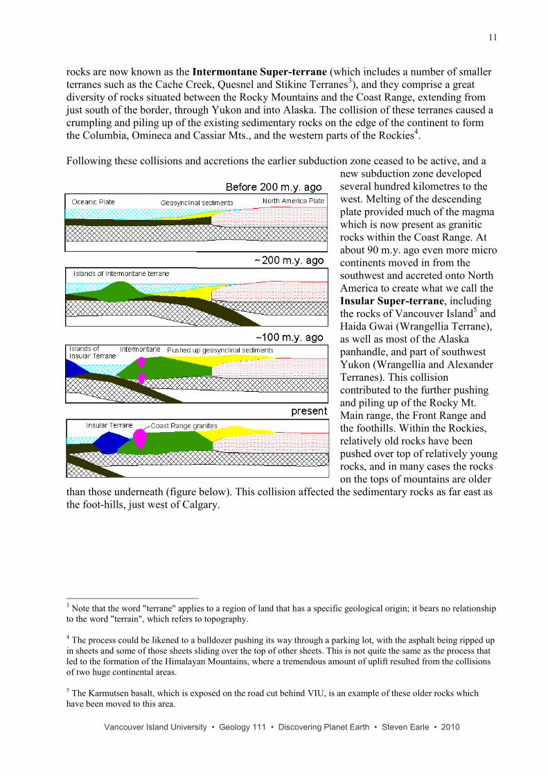
rocks are now known as the Intermontane Super-terrane (which includes a number of smaller
terranes such as the Cache Creek, Quesnel and Stikine Terranes3), and they comprise a great
diversity of rocks situated between the Rocky Mountains and the Coast Range, extending from
just south of the border, through Yukon and into Alaska. The collision of these terranes caused a
crumpling and piling up of the existing sedimentary rocks on the edge of the continent to form
the Columbia, Omineca and Cassiar Mts., and the western parts of the Rockies4.
Following these collisions and accretions the earlier subduction zone ceased to be active, and a
new subduction zone developed
several hundred kilometres to the
west. Melting of the descending
plate provided much of the magma
which is now present as granitic
rocks within the Coast Range. At
about 90 m.y. ago even more micro
continents moved in from the
southwest and accreted onto North
America to create what we call the
Insular Super-terrane, including
the rocks of Vancouver Island5 and
Haida Gwai (Wrangellia Terrane),
as well as most of the Alaska
panhandle, and part of southwest
Yukon (Wrangellia and Alexander
Terranes). This collision
contributed to the further pushing
and piling up of the Rocky Mt.
Main range, the Front Range and
the foothills. Within the Rockies,
relatively old rocks have been
pushed over top of relatively young
rocks, and in many cases the rocks
on the tops of mountains are older
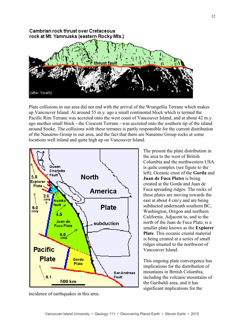
than those underneath (figure below). This collision affected the sedimentary rocks as far east as
the foot-hills, just west of Calgary.
3 Note that the word "terrane" applies to a region of land that has a specific geological origin; it bears no relationship
to the word "terrain", which refers to topography. 4 The process could be likened to a bulldozer pushing its way through a parking lot, with the asphalt being ripped up
in sheets and some of those sheets sliding over the top of other sheets. This is not quite the same as the process that
led to the formation of the Himalayan Mountains, where a tremendous amount of uplift resulted from the collisions
of two huge continental areas. 5 The Karmutsen basalt, which is exposed on the road cut behind VIU, is an example of these older rocks which
have been moved to this area.
Vancouver Island University • Geology 111 • Discovering Planet Earth • Steven Earle • 2010
12
Plate collisions in our area did not end with the arrival of the Wrangellia Terrane which makes
up Vancouver Island. At around 55 m.y. ago a small continental block which is termed the
Pacific Rim Terrane was accreted onto the west coast of Vancouver Island, and at about 42 m.y.
ago another small block - the Crescent Terrane - was accreted onto the southern tip of the island
around Sooke. The collisions with these terranes is partly responsible for the current distribution
of the Nanaimo Group in our area, and the fact that there are Nanaimo Group rocks at some
locations well inland and quite high up on Vancouver Island.
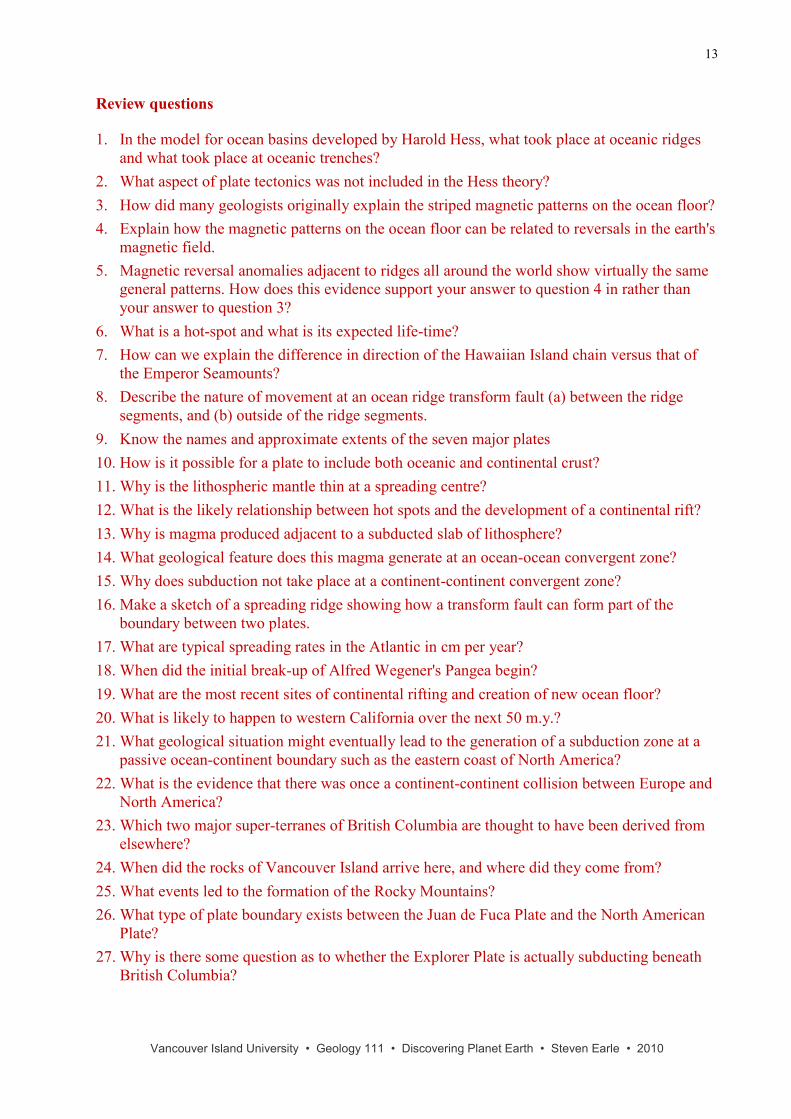
The present the plate distribution in
the area to the west of British
Columbia and the northwestern USA
is quite complex (see figure to the
left). Oceanic crust of the Gorda and
Juan de Fuca Plates is being
created at the Gorda and Juan de
Fuca spreading ridges. The rocks of
these plates are moving towards the
east at about 4 cm/y and are being
subducted underneath southern BC,
Washington, Oregon and northern
California. Adjacent to, and to the
north of the Juan de Fuca Plate, is a
smaller plate known as the Explorer
Plate. This oceanic crustal material
is being created at a series of small
ridges situated to the northwest of
Vancouver Island.
This ongoing plate convergence has
implications for the distribution of
mountains in British Columbia,
including the volcanic mountains of
the Garibaldi area, and it has
significant implications for the
incidence of earthquakes in this area.
Vancouver Island University • Geology 111 • Discovering Planet Earth • Steven Earle • 2010
13
Review questions
1. In the model for ocean basins developed by Harold Hess, what took place at oceanic ridges
and what took place at oceanic trenches?
2. What aspect of plate tectonics was not included in the Hess theory?
3. How did many geologists originally explain the striped magnetic patterns on the ocean floor?
4. Explain how the magnetic patterns on the ocean floor can be related to reversals in the earth's
magnetic field.
5. Magnetic reversal anomalies adjacent to ridges all around the world show virtually the same
general patterns. How does this evidence support your answer to question 4 in rather than
your answer to question 3?
6. What is a hot-spot and what is its expected life-time?
7. How can we explain the difference in direction of the Hawaiian Island chain versus that of
the Emperor Seamounts?
8. Describe the nature of movement at an ocean ridge transform fault (a) between the ridge
segments, and (b) outside of the ridge segments.
9. Know the names and approximate extents of the seven major plates
10. How is it possible for a plate to include both oceanic and continental crust?
11. Why is the lithospheric mantle thin at a spreading centre?
12. What is the likely relationship between hot spots and the development of a continental rift?
13. Why is magma produced adjacent to a subducted slab of lithosphere?
14. What geological feature does this magma generate at an ocean-ocean convergent zone?
15. Why does subduction not take place at a continent-continent convergent zone?
16. Make a sketch of a spreading ridge showing how a transform fault can form part of the
boundary between two plates.
17. What are typical spreading rates in the Atlantic in cm per year?
18. When did the initial break-up of Alfred Wegener's Pangea begin?
19. What are the most recent sites of continental rifting and creation of new ocean floor?
20. What is likely to happen to western California over the next 50 m.y.?
21. What geological situation might eventually lead to the generation of a subduction zone at a
passive ocean-continent boundary such as the eastern coast of North America?
22. What is the evidence that there was once a continent-continent collision between Europe and
North America?
23. Which two major super-terranes of British Columbia are thought to have been derived from
elsewhere?
24. When did the rocks of Vancouver Island arrive here, and where did they come from?
25. What events led to the formation of the Rocky Mountains?
26. What type of plate boundary exists between the Juan de Fuca Plate and the North American
Plate?
27. Why is there some question as to whether the Explorer Plate is actually subducting beneath
British Columbia?