Embed Size (px)
Citation preview
DRILL REPORT CUMBERLANJJ GROUP MT. MADGE PROJECT SULPAURETS CREEK AREA NTS 104B/8 SKRENA MINING iiVISION BRITISH COLDMBIA
c
OWNER: RITSLXO TSURUGIDA (E.R. KXUCHKOWSKI - AGENT FOR) AND CATEAR RESOURCES LTD.
OPERATOR: BIGHORN DEVELOPMENT CORPORATION
AUTHOR: E.J. HORNE GEOLOGICALBRANCH ASSESSMMNT RFPnPT
DATE: FEBRUARY 7, 1988
17,205
TABLE OF CONTENTS
1.0 EXECUTIVE SUMMARY. .................
2.0 INTRODUCTION .....................
2.1 Location and Access ..............
2.2 Physiography and Topography ..........
2.3 History and Ownership .............
2.4 Previous Work .................
3.0 SUhXARY OF WORK DONE AND PERSONNEL .........
3.1 Silt Sampling .................
3.2 Soil Sampling .................
3.3 Prospecting & Geological Mapping ........
3.4 Trenching and Sampling Workings ........
3.5 Drilling ....................
4.0 GEOLOGY AND ECONOMICS ................
4.1 Regional Geology ................
4.2 Local Geology .................
4.3 Structural Geology ...............
4.4 Economic Geology ................
5.0 DIAMOND DRILLING ..................
5.1 Drill hole Locations and Data .........
5.2 Discussion of Core Descriptions ........
5.3 Discussion of Assay Results ..........
5.4 costs .....................
Page No.
1
3
3
4
4
6
7'
8
8
10
11
11
12
12
13
14
15
16
16
17
18
21
. Cont'd'...*i2
TABLE OF CONTENTS (Cont'd . ..) -2-
6.0 CONCLUSIONS . . . . . . . . . . . . . . . . . . . . .
7.0 RECOM%NDATIONS . . . . . . , . . . . . . . . . . . .
8.0 CERTIFICATION . . . . . . . . . . . . . . . . . . . .
9.0 REFERENCES . . . . . . . . . . . . ; . . . . . . . .
FIGURES
FIGURE 1 Location Map
FIGURE 2 Access and Topography Map
FIGURE 3 Claim Location Map
FIGURE 4 Silver Creek Soil Grid
TABLES
TABLE1 Work Summary
TABLE 2A Upper Adit Samples - Cumberland Showing
TABLE 2B Lower Adit Samples - Cmberland Showing
APPENDICES
APPmIXA Itemized Cost Statement
APPENDIX B
APPENDIX C
APPENDIX D
APPENDIX E
MAP1
MAP2
MAP3
SECTION 070
SECTION 081
SECT103 110
Page No.
22
23
24
25
Rock and SailCertificates of Assay and Geochemical Analysis
Drill Hole Certificates of Analyses and Assay
Drill Logs
Historical Data
MAPS & SECTIONS (BACK POCKET)
Sample Location Map - Scale 1:2500 (Figure 5)
Geological and Geochemical - Scale 1:500 (Figure 6)
Drill Hole Plan - Scale 1:lOO (Figure 7)
BH-1, 2 & 3 Scale 1" - 20' (Figure 8)
BH-6 OR 1:240 (Figure 9),~~
BH-4, 6 5 (Figure 10) ~~_. .F-
“.
1.0 EXECUTIVE WMMARY
c This assessment report on the Cumberland Group of claims consisting of
reverted drown grant Z-post claims lots 265 to 269 and the Corey 8, 28, 31,
32 and 35 mineral claims (97 units) is submitted to the British Columbia
Ministry of Energy Mines and Petroleum Resources in partial compliance
with the Mines Regulations Act pertaining to application for assessment
work credit.
The preliminary field work was performed from August 1st to August 14th,
1987, subsequently the Cumberland showing was diamond drilled (~six holes,
1936 feet). Work related to this drilling took place between September 19
to November 1, 1987.
The project operator, Bighorn Development Corporation commissioned E.R.
Kruchkowski Consulting Ltd. to direct both field programs. The primary
mineralized targets were precious metals, gold and silver, that occur on
three principal locations which are as follows:
- The Cumberland showing, this showing was trenched and drilled.
- The Devils Club Creek showing.
- The Silver Creek showing.
The latter two showings were prospected and sampled. They both require
further more systematic investigation.
The total field program consisted of the following work:
i -~
i
- Soil geochemical sampling on the Cumberiand,Silver Creek showings.
- Silt geochemical sampling on available drainage.
- Rock geochemical sampling in the vicinity of all showings and areas
prospected. i
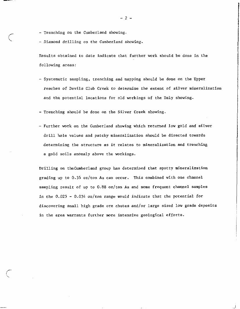
c - Trenching on the Cmberland showing.
- Diamond drilling on the Cumberland showing.
Results obtained to date indicate that further work should be done in the
following areas:
- Systematic sampling, trenching and mapping should be done on the Upper
reaches of Devils Club Creek to determine the extent of silver mineralization
and the potential locations for old workings of the Daly showing.
- Trenching should be done on the Silver Creek showing.
- Further work on the Cumberland showing which returned Tow gold and silver
drill hole values and patchy mineralization should be directed towards
determining the structure as it relates to mineralization and trenching
a gold soils anomaly above the workings.
Drilling on theCumberland group has determined that spotty mineralization
grading up to 0.35 oz/ton Au can OCCUI-. This combined with one channel
sampling result of up to 0.88 oz/ton Au and some frequent channel samples
in the 0.025 - 0.034 oz/ton range would indicate that the potential for
discovering small high grade ore chutes and/or large sized low grade deposits
in the area warrants further more intensive geological efforts.
2.0 INTRODUCTION
The Cumberland group of claims consist of the following reverted crown grant
(2-post) claims and mineral claims Corey 8:
Recording
5473 5474 5475 5476 5477
crown Grant Area Lot Number (Hectares) Anniversary Date
Cumberland L265 13.86 August 1, 1986 Silver Pine L266 15.97 August 1, 1986 Middlesex l.267 20.85 August 1, 1986 Ziphis L268 11.63 August I, 1986 Ougma L269 12.98 August 1, 1986
5412 Cm-w 8 June 25, 1'386 5893 Core; 28 16 Febrnar$ 11, 1987 5896 Corey 31 16 February 11, 1987 5897 Corey 32 20 February 11, 1987 5900 Corey 35 20 February 11, 1987
All of the above claims h&e been grouped into the Cumberland group of
claims by a supplemental grouping notice dated January 28, 1987. The
claim group layout is illustrated on Figure 3.
2.1 Location and Access
The principal claims are located in the Sulphurets Creek area NTS 104B/8
of the Skeena Mining Division in the vicinity of latitude 56'29' longitude
129°29'30', approximately 1.2 kilometres east of the Sulphurets Creek
Unuk River confluence. See location and access maps (Figures 1 h 2). The
property is approximately 70 kilometres north-northwest of Stewart,
British Columbia. Access to the claims was achieved by Bell 206 Jet
Ranger helicopter. The drill was long-lined onto the drill pad by Bell 204.
During the initial phase of work the campsite was established in the
vicinity of the Unuk River junction. This site was relocated to the
Cumberland showing area during the later (drilling) phase of work.
-4-
During the initial phase of work a trail was blazed from the first campsite
to the showing, a distance of 1.1 kilometres. This distance was deemed too
great for effective drilling. Therefore, the existing chopper pad at the
main showing was upgraded and a new campsite was cleared at the drillsite
on the Cmberland showing on Lot 265.
2.2 Physiography and Topography
The property is located in very steep terrain in the vicinity of the
Sulphurets Creek Canyon. The elevations vary from 214 metres (700 feet)
AMSL to 1691 metres (5548 feet) AMSL on Mt. Madge.
The main tributaries feeding the drainage have their origin in the glacial
tongues and icefields that typify the coast range. Below tree line the
area is densely timbered with spruce, hemlock, cedar and balsam. The
river areas have some cottonwood stands with dense undergrowth of alder
and devils club.
The area is characterized bymoderate to heavy snowfall and low winter
temperatures. Summer precipitation, although less than at the immediate
coast, is frequent and heavy enough to hamper geological work. The
weather during the fall drilling program, which ended November 1, 1987,
was foggy and damp with daily precipitation.
2.3 Histovand Ownership
The Cumberland group of claims (lots 265-289) was originally staked in
1898. The claims were subsequently sold to the Unuk River Mining and
DredgLng Company in 1900 and development work was done until 1903, at
-5-
which time development ceased.
In 1931 the property "as purchased by a tax sale by Mr. George E. Olmsted
but no further development work was done on the property.
Historical data on the claims can be reviewed in the following British
Columbia reports of the Minister of Mines and the 1905 GSC Sumnary (Report
P-51):
,.
Year w
1901 994 1903 54 1906 72 1919 60 1923 87 1935 89-11
Other mre recent work is included in the October, 1964 Western Miner
(P-36) and Assessment Report 8769 (1980) for E 6 B Exploration Ltd.
The current owner of the 2-post claims is Mr. Ritsuko Tsurigida (1987 FMC
297219) who has a royalty agreement with Catear Resources Ltd. that entitles
Catear to a 100X working interest. Catear Resouces Ltd. of #400, 255 - 17
Avenue S.W., Calgary, Alberta is also the owner of the Corey claims.
Bighorn Development Corporatim of 8400, 255 - 17 Avenue S-W., Calgary,
Alberta is the operator on both the crown grant L265-269 (2-post claims)
and the Corey claims. The operator earns an interest in the claim group
through expenditures on the property. E.R. Kruchkowski is agent for all
of the parties involved.
- 6-
2.4 Previous Work
Previous work on the showings located on lots 265 to 269 consisted of minor
underground development work on the Daly and Cumberland prospects. The
location of the Daly prospect has not to date been ascertained, recent
work on Devils Club Creek suggests that it may be in the upper reaches,
however the previously reported elevation of 1200 feet for the showing does
not concur with field data. The Cumberland showing, located on lot 265,
occupies a rusvgully which is quite visible from the north side of Sulphurets
Creek.
The locations of the available workings are shown on enclosed maps 1, 2,
and 3 and discussed in more detail in other sections of this report.
Further details on previous work is included in Appendix E and consists
of summarized historical data from selected British Columbia Minister of
Mines reports. All indications are that these showings were last examined
in the 1960's, this is inferred by the presence of an old chopper and the
1964 Western Miner report. Nonetheless, indications are that the last
serious work done is of 1935 vintage as no new trenching or blasting was
noted.
-7-
c 3.0 SUMMARY OF WORK DONE AND PERSONNEL USED
The work program took place in two separate phases which consisted of a
field exploration phase form August 1 to August 14, 1987 and a drilling
phase from September 19 to November 1, 1987.
The personnel used were provided by E.R. Krucbkowski Consulting Ltd. Their
rates and days worked are itemized in Appendix A. A chart (Table 1) is
provided to show the job activities and man/days that is assigned to each
job function.
A brief summary of the work accompanied is as follows:
- line cutting trail from first camp to Cumberland showing,
- establish Cumberland showing soils grid, 1.0 kilometres.
- map soils grid (.03 kilometres').
- prospecting and sampling (approx. 3.0 line kilometres).
- establish Silver Creek soils grid, 0.2 line kilometres.
- prospect and sample grid (-01 kilometresz).
- trenching, 10 line mares (10 x 1.0 x 0.5 deep)
- map workings, 20 line metres.
- diamond drilling 1936 feet (590 metres).
- log core (590 metres).
- soil sampling 182 samples.
- silt sampling 10 samples.
- rock samples 72 samples.
- core samples 363 samples.
- ixqnovements on chopper pad and campsite.
..l line kilometres.
-8 -
The results of the 1987 field programs are discussed in this report, maps
and cross sections are provided to illustrate the established grids for
soil sampling, the results of geological mapping, the location of trenches
or workings and the location of core holes.
All analytical results are provided in Appendices B and C, the drill logs
are included in Appendix D.
3.1 Regional Silt Sampling
The silt sampling was done on the available streams to determine the most
likely areas to prospect for precious metals (Au, Ag). The procedure for
silt sampling included the use of a pan and fly screen to size the silt
sample to less than 1.0 mm. The sampling proved effective in locating
areas of interest such as devils Club Creek and Silver Creek where subsequent
work resulted in obtaining in place albeit narrow quartz-carbonate vein
material that assayed as follows:
tication Sample No. Assay AR m/ton Rock Type
Silver Creek 18007 102.15 7 cm quartz carbonate 9599 133.59 10 cm and silver sulphosalts
Devils Club Creek 19442 160.92 20 cm quartz manganese 19443 3.62 30 cm carbonate and carbonate
wallrock
On the basis of the above results derived from silt samples such as CG-08
(6.2 ppm Ag) and CG-09 (+30 ppm Ag), further silt sampling covering all of
the drainage in the area is strongly recommended.
3.2 Soil Sampling .~
Soil sampling was done at two locations which are shown on Map 1 (Figure 5).
They include the Silver Creek soils grid (28 samples) shown on Figure 4
c
-9-
and Cumberland soils grid (174 samples) shown on Map 2, Figure 6. In
the case of the Silver Creek soils grid background values for Au is 5 to
10 ppb and for Ag is 0.1 ppm. homalous values for Au is in the order of
85 ppb (one sample) with numerous anomalous Ag samples (+I.0 ppm). The
soils sampled at this location consisted of dark brown "B" horizon at
depths of 20 cm - 30 cm (10 cm sample interval). In the case of the
Cnmberland soils grid,background values for Au is in the order of nil to
10 ppb with anomalous values of +25 ppb which occurs in the following
localities:
- adit area. Baseline O+OO to M30 south
- in the vicinity of the baseline and C+75 to l+OO south
- in the vicinity of C+50 south and 20 west
- in the vicinity of 0+50 to 0+75 south and 20 east
The highest soils value taken directly above the upper adit returned
+1000 ppb or 0.140 oz./ton. Background values for Ag on the Cumberland grid
is nil to 0.2. Anomalous Ag values were considered to be +l.O ppm. The
localities for anomalous values the highest of which were 6.8, 7.7 and 8.2
ppm do not line up, show continuity or appear to be associated with anomalous
gold areas.
The soil samples were taken on a leached greyish “c” horizon at depths
of +20 cm. In some localities organic A and B horizon material only vast
present. ~A description of the soil type horizon and depth is annotated on
the assay results included in Appendix B. The results of the sampling
are plotted on Map 2, Figure 6, and Figure 4.
I
-10 -
c 3.3 Prospecting and Geological Happing
Stream silt sampling on Devils Club Creek resulted in prospecting up the
creek bed looking for source rock containing high silver values. Preliminary
work resulted in locating rounded float bbulders of greenish carbonate
breccia and stockwork with fine fracture fill of carbonate quartz. with
sphalerite pyrite mineralization containing silver.
Typical assay results for this material include values as follows:
Sample NO.
18082 18083 18085 18086
Assay oz/ton Ag Description
Float 10.18 carbonate stockwork Float 29.66 green grey color with Float 50.46 hairline sphalerite pyrite Float 53.54 fractures and strong manganese
stain.
/- 'k
This float type was traced up Devils Club Creek to the source area (Hap 2,
Figure 6) which occurs in a narrow steep gulch that contained blocks of
scree of the source rock. High grade samples of this scree returned values
of 346.4 oz/ton Ag and 169.38 oz/ton Ag. Some wallrock material contained
up to 4.26 oz/ton Ag and in-situ 20 cm wide vein returned 160.92 oz/ton Ag.
This area is now considered to be the source area for the Daly showing
referenced in Appendix E. The favourable mineralization and host rock
occurs frequently over a distance of 100 metres.. The scree slopes are
steep and bedrock exposure along the northern wall of the gulch.is~scarce.
Indications at present are that a large area of carbonate stock host rock
occurs within a fault wedge and that locally this carbonate contains
wider sulphide rich vein intersections that contain appreciable silver
VZlUes. Further work in this area is required to expose bedrock and sample
in-situ material; some very old eabfn cribbing was noted in~the area.
The old portal for the Daly showing is suspected to occur in an area of
strong manganese stained scree directly below the cabin.
--
IT- \
- 11 -
3.4 Trenching and Sampling Workings
Work in the form of trenching was done on the Cumberland showing in the
area of the upper adit. The results of this trenching and adit sampling
are shown on Table 2A. The results of s&pling for the lower adit are
shown on Table 2B. The locations of trenches, workings and the 1987
core holes are all shown in Map 3, Figure 7. Overall the trench sampling
indicated that low gold values could be encountered with moderate frequency
even though no high grade massive sulphlde was encountered in the trenches
and that this high grade zone showed a discontinuous nature from the mapping
that was done in the upper adit.
Results of high grade samples taken from the upper adlt area returned high
gold values of 0.118 oz/ton (50 cm) and 0.88 m/ton (40 cm). Subsequent
resampling of this main zone returned values from 0.180 to 0.422 oz/ton
Au over widths of 80 cm. Silver was ubiquitous in the high grade area of
the upper adit with values varying from 1.09 to 16.58 oz/ton. The decision
to drill was based on the possibility of encountering extensions of this
zone at depth and in a southward direction.
3.5 Drilling
A fall program of 1936 feet of core drilling was completed in the upper
adit area. Results of this program are detailed in Section 5 of this
report.
-.I2 -
c-
,-
f-- i.
4.0 GEOLOGY AND ECONOMICS
4.1 Regional Geology
The claims lie in the Sulphurets Creek area which is along the east edge
of the Coast Crystalline Complex and near the boundary of the Bowser Basin.
The rocks of the area belong to the Mezosoic Hazelton Group and have been
intruded by plugs of Cenozoic and Mesozoic age.
The oldest rocks in the area belong to the Lower Jurassic Unuk River
Formation which forms a north-northwesterly trending belt extending from
Alice Arm to the Iskut River. This unit consists of green, purple.and some
red volcanic breccia, conglomerate, agglomerate and tuff. Also included
in the sequence are pillow laws, volcanic flows and claslzic sediments.
The Unuk River Formation is unconformably overlain by Lower Middle and
Middle Jurassic rocks of the Betty Creek and Salmon River Formations
respectively. These latter formations are interpreted to be absent in the
area of the claims.
According to E.W. Grovethe majority of the rocks from the Hazelton Group
were derived by erosion of andesitic volcanics and subsequent deposition
as overlapping lenticular beds grading from coarse breccia to siltstone.
The area of the claims is located predominately in coarser sections of
these overlapping sequences. Intrusive rocks in the vicinity comprise
diorite and syenodiorite or Mesozoic age (Mt. Madge, Unuk River and Twin
John Peaks) and monzonite of Cenozoic age, large mass of which occurs
southeast of the property.
Structurally the main belt of exposed Unuk River Formation forms a major
north-westerly trending domical structure which in the Sulphurets Creek
area is reflected by a simple antiform which has been fragmented by
- 13 -
c plutonic implacement and intense faulting.
An early Jurassic north trending anticline is interpreted by E.W. Grove
to occur at the junction of the Unuk River and Sulphurets Creek.
42. Local Geology
Geological mapping was done over the Cumberland grid and Devils Club Creek
areas (approximately 0.5 Km') indicates that the area contains the following
rock types:
- dacite and dacitic agglomerate and andesite dacite wlcanics (crystal
and lithic tuff) of Lower Jurassic Unuk River Formation,
- dacitic and chert pebble agglomerate of Lower Jurassic Unuk River
Formation,
- black argillite with minor pyrite also interpreted to belong to the
Lower Jurassic Unuk River Formation,
- carbonate stockwork of Lower Jurassic Unuk River Formation.
The mapping did not distinguish finer lithological subtleties such as the
presence or absence of red chert (jasper) and the degree of fragmental
versus massive volcanic nature OF the andesitic/dacitic units.
Regional prospecting and mapping was also done along the cliff face below
the upper and lower adits. The rock types in this rusty gossan like area
consist of andesite and or intermediate flows and fraguentals with minor
pyrite and strong jointing and/or fracturing. Traverses were also done
down Devils Club Creek to the junction of Sulphurets Creek. .sOme intermediate
-14 -
c to felsic tuffaceous wedges were noted in proximity to Sulphurets Creek.
Sampling in this area returned low Au, Ag values (nil, 0.2) as shown for
samples 9595 and 9696. A sample of rusty tertiary gravel at Sulphurets
creek sample 9598 returned 65 ppb Au. The- geological reconnaissance mapping
did not encounter any strong quartz veining or sericitic mineralization
zones such as those encountered on Mt. Madge and the Brucejack Lake area,
the latter of which is undergoing underground mine development work for
lode gold and silver.
4.3 Structural Geology
Structural geological data such as shearing, jointing intense fracturing
is plotted on Maps 2 and 3. The area of Devils Club Creek is interpreted
to be a major fault zone that splays from the Sulphurets Creek Canyon which
in turn is interpreted to occupy a major fault zone.
Slickensided boulders and some in-situ slickensides were noted in Devils
Club Creek (Figure 6) in the same area a secondary fault zone is indicated
by a lithological discontinuity in a narrow gulch in the upper reaches
of Devils Club Creek. The north-east wall of the gully contains a carbonate
stockwork and the south-west side contains dacitic agglomerate.
In the Curoberland showing area (Figure 7) two major shearing trends prevail,
one is roughly parallel the Sulphurets Creek Canyon AZ X0-220 and conjugate
shearing at AZ 330-340. The downthrow blocks are towards Sulphu&s
Creek. At the Cumberland showing in the upper adit small scale ripple
plunge structures can be noted adjacent to the mineralized zone. These
structures also steeply (75') plunge towards Sulphurets Creek.
The drilling which was done in the fall encountered gouge zones, highly
.
-15 -
c
/
r , ‘L.
fractured rusty zones and quartz healed hairline fracture mnes which
indicated a complex history of shearing and fracturing. Also regional
work in the area to the north suggests some fault related drag folding.
4. Economic Geology
In the Sulphurets area, gold and silver mineralization appears to be of
epithermal vein type origin that is structurally controlled and visually
in close association with volcanic rocks. The veins commnly consist of
quartz and carbonate with up to 20-30% sulphides within complex vein/shear
zones or stockworks. Common associated &erals are pyrite, sphalerite,
galena, tetrahedrite, arsenopyrite, electrum, pyrargyrite and barite. At
the Cumberland showing the massive sulphide zone consisted of pyrite,
sphalerite, galena, chalcopyrite and barite with some silver sulphosalts?
and associated gold. This assemblage is more consistent with the high
barite gold association that is mre commonly encountered in the Kitsault
area and is interpreted to be a replacement vein deposit which only con-
stitute 5% of the mineral deposits in the Stewart complex but comprise
more than 90% of the total gold, silver, lead and zinc mined. These low
gold replacement vein types such as at the Tobrit and Alice Arm deposits
consist of discordant lenses comprised of banded quartz, barite, jasper,
feldspar, carbonates. The ore shoots include sulphides and native silver
that along with the main vein material formed partly by implacement within
fractures and partly by replacement of wallrock. The mineral assemblance
and discontinuous ore shoot nature (steeply plunging) of then Cumberland
showing closely resembles the above replacement vein model.
In the Cevils Club Creek area "Daly" showing consists of a carbonate
breccia stockwork with some narrow lo-20 cm wide vein intersections. The
mineral assemblage is pyrite sphalerite and silver rich with notably low
gold values. , -~ -c
-.16 -
- /
c
5.0 DIAMOND DRILLING
D.W. Coatrs Enterprises Ltd. completed a total of 1936 feet (590 metres)
of coring to intersect the mineralization noted on the Cumberland adits.
The drilling was done with a JKS 300 hydraulic wireline core rig. The
core diameter was 41.28 (BDGM). The core was split for sampling and logged
at the drillsite. The remaining (now split core) and half core is cross
racked in five (5) foot wooden core boxes at the site and is readily avail-
able for further investigative work.
The sample section of split core (commonly a five foot inferval) was bagged,
tagged and sent to Loring Laboratories Ltd. of calgary, Alberta for either
gold, silver assay or rock geochemical analysis.
5.1 Drill Hole Locations and Data
Six (6) holes were drilled from one drill station located as shown on
Map 3 (Figure 7). The specifics of the drill hole fan directions are as
follows:
Drill Hole
?qtai Depth
Incllncation Direction AZ. PUTWXS ~%+et
BH-1 44.5O AZ 070 Intersect zones 4X6
BH-2 60’ AZ 070 of miner&lizat&an 334
BH-3 79 AZ 070 on uppa and 459
BH-4 45O AZ 110 louer~adi?s 239~
BH-5 60’ AZ 110 2091
BH-6 46’ AZ 081 279
The ground drilled was blocky with frequent jointing at low angles to ..
the core axis which lead to frequent small losses of circul+tion~and~~:~.
difficulties in removing the core from the barrel due to wedge binding.
Core recoveries overall were excellent (95%).
c
c
-17 -
Mineralization was noted in core holes BH-1, 2 and 6. Core holes BH-3, 4,
5 did not intersect mineralization which indicates that the zone is not
continuous. Data to date suggests that the mineralized zones occu-r as
shoots and are of a fissure replacement type.
Interpretations of the data are included on Map 3 (Figure 7) and cross
sections 070, 110 and 081 (Figures 8 to 10). The analytical results and
core descriptions are included in Appendix C and D.
5.2 Discussion
The core descriptions are included in Appendix D. The primary units
given in the general order that they were encountered are as follows:
- Andesiteldacite. This unit consisted of light grey to dark green mafic
to intermediate massive volcanic rock with common lmm or less sized mafic
amphibole phenocrysts or crystal fragments. Pyrite and/or pyrrhotite was
generally ubiquitous in amounts (Tr to 5%) and is typically fine grained
and located along the margins of white hairline quartz-carbonate fractures
typically 15 - 45' to the core axis. Alteration consisted of limonitization
along open fractures some epidotization and silicification.
- Dacitic fragmental/silicified greenstone. This unit consisted of light
green to light grey silicified fragmental or brecciated intermediate volcanic
with some quartz feldspar eyes (up to 5 mm size 20% of unit). The frag-
mental nature was exhibited by round and angular fragments or clasts up to
2 cm size and frequent crystal fragments of felsic affinity. This unit
also contained frequent pyrite and/or pyrrhotite along hairline quartz and
quartz carbonate fractures as previously described,' The predominate min-~ :
eralized zones occur within this unit and consist of a barite rich massive
sulphide zone that is greyish in coleus and contains minor sphalerite,
-18 -
galena and tetrahedrite, and pyrrhotite chalcopyrite massive sulphide stringers
up to 30 cm wide that combined are described as the pyrrhotite chalcopyrite
zone, see figure 8.
- First Jasper Group. This unit consists of a purple/red jasper rich (+lO.Z)
mafic volcanic or volcanic/sedimentary unit which is characterized by dark
color, presence of jasper, cormran pale green epidote and dense massive nature
which resulted in poor drilling penetration rates. Pyrite cubes up to 5 mm
size were noted in this unit, however, sulphide mineralization was not very
~~mrmn in the group overall. One analysis, BH-1 30456, resulted in a j-foot
section assaying 0.152 oz/ton. Sampling was not done on either side of this -
interval and future efforts will be directed to checking this area more fully.
5.3 Discussion of Assay Results
A summary of mineralized sections encountered during the six hole program
in which only three of the holes encountered mineralization of significant
but sub-economic grade is as follows:
i
-19 -
c
,-
c
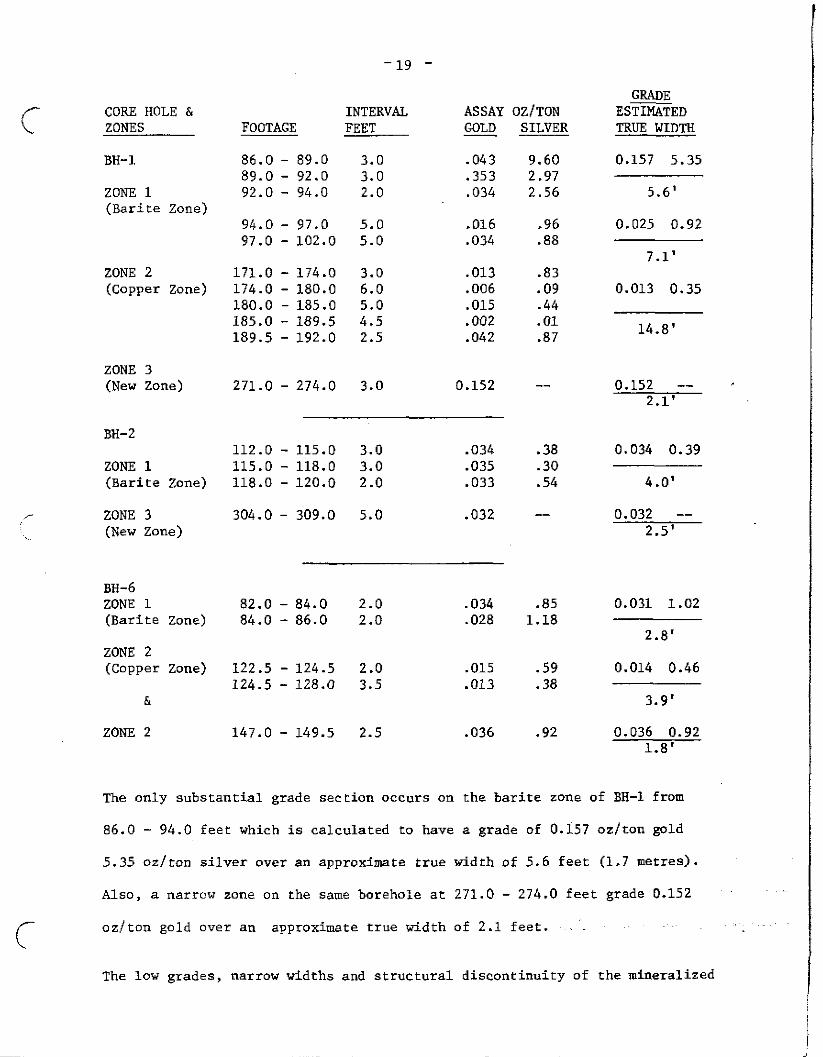
CORE HOLE & ZONES
BH-1
ZONE 1 (Barite Zone)
ZONE 2 (Copper Zone)
ZONE 3 (New Zone)
BH-2
ZONE 1 (Barite Zone)
ZONE 3 (New Zone)
BH-6 ZONE 1 (Barite Zone)
ZONE 2 (Copper Zone)
&
ZONE 2
INTERVAL FOOTAGE FEET
86.0 - 89.0 3.0 89.0 - 92.0 3.0 92.0 - 94.0 2.0
94.0 - 97.0 5.0 97.0 - 102.0 5.0
171.0 - 174.0 3.0 174.0 - 180.0 6.0 180.0 - 185.0 5.0 185.0 - 189.5 4.5 189.5 - 192.0 2.5
GRADE ASSAY OZfTON ESTIMATED COLD SILVER TRUE WIDTH
.043
.353 .034
.016
.034
.013
.006 .015 .002 .042
9.60 2.97 2.56
.96
.a8
.83 .09 .44 .Ol .87
271.0 - 274.0 3.0 0.152 --
112.0 - 115.0 3.0 .034 115.0 - 118.0 3.0 .035 118.0 - 120.0 2.0 .033
304.0 - 309.0 5.0 .032
82.0 - 84.0 2.0 .034 84.0 - 86.0 2.0 .028
122.5 - 124.5 2.0 .015 124.5 - 128.0 3.5 .013
147.0 - 149.5 2.5 .036
.38 -30 .54
--
.a5 1.18
.59 .38
.92
0.157 5.35
5.6'
0.025 0.92
7.1'
0.013 0.35
14.8'
0.152 -- , 2.1'
0.034 0.39
4.0'
0.032 -- 2.5'
0.031 1.02
2.8'
0.014 0.46
3.9’
0.036 0.92 1.8'
The only substantial grade section occurs on the barite zone of BH-1 from
86.0 - 94.0 feet which is calculated to have a grade of 0.157 oz/ton gold
5.35 cm/ton silver over an approximate true width of 5.6 feet (1.7 metres).
Also, a narrow zone on the same borehole at 271.0 - 274.0 feet grade~0.152 ~'
ozfton gold over an approximate true width of 2.1 feet. ~~~ .~
The low grades, narrow widths and structural discontinuity of the mineralized
-20 -
c zone are disconcerting. However, further work will continue in this zone for
possible other mineralization.
Structural data suggests a cross fissure related ore shoot structural style,
repetition of this type of structure in the vicinity should be investigated
more fully.
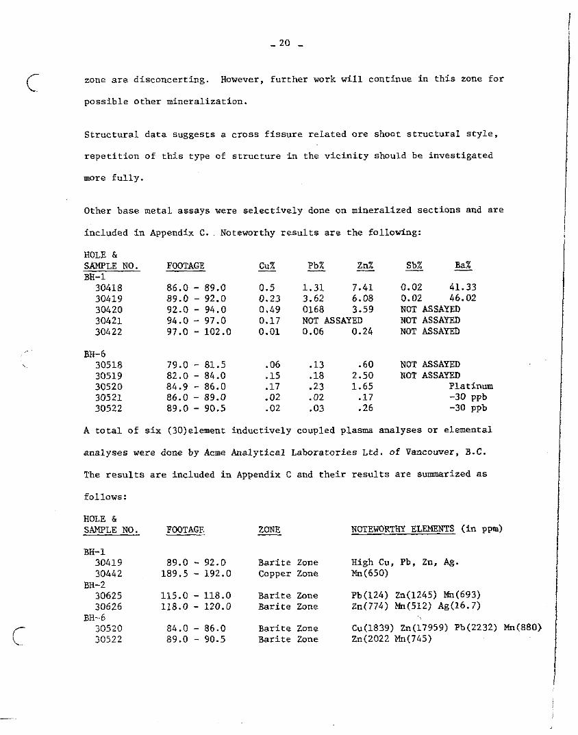
Other base metal assays were selectively done on mineralized sections and are
included in Appendix C.. Noteworthy results are the following:
HOLE & SAMPLE NO. FOOTAGE cux Pb% Zn% Sb% Ba% - _ - - - BH-1
30418 86.0 - 89.0 0.5 1.31 7.41 0.02 41.33 30419 89.0 - 92.0 0.23 3.62 6.08 0.02 46.02 30420 92.0 - 94.0 0.49 0168 3.59 NOT ASSAYED 30421 94.0 - 97.0 0.17 NOT ASSAYED NOT ASSAYED 30422 97.0 - 102.0 0.01 0.06 0.24 NOT ASSAYED
BH-6 30518 79.0 - 81.5 .Ob .13 .60 NOT ASSAYED 30519 82.0 - 84.0 .15 .18 2.50 NOT ASSAYED 30520 84.9 - 86.0 .17 .23 1.65 Platinum 30521 86.0 - 89.0 -02 .02 .17 -30 ppb 30522 89.0 - 90.5 .02 .03 .26 -30 ppb
A total of six (30)element inductively coupled plasma analyses or elemental
analyses were done by Acme Analytical Laboratories Ltd. of Vancouver, B.C.
The results are included in Appendix C and their results are sumarized as
follows:
NOTEWORTHY ELEMENTS (in ppm) HOLE & SAWLE NO. FOOTAGE
BH-1 30419 89.0 - 92.0 Barite Zone High Cu, Pb, Zn, Ag. 30442 189.5 - 192.0 copper zone Mn(650)
BH-2 30625 30626
115.0 - 118.0 Barite Zone Pb(124) Zn(1245) Mn(693) 118.0 - 120.0 Barite Zone zn(774) Mn(512) Ag(16.7)
BE--b 30520 30522
84.0 - 86.0 Barite Zone Cu(1839) Zn(17959) Pb(2232) Mn(880> 89.0 - 90.5 Barite Zone Zn(2022 Mn(745)
c-- ‘\.
- 21 -
The barium content in all caws was low, sample 30419 assayed 46.02%
barium yet the elemental analysis result for the sample was only 25 ppm.
Explanations for this are that barium is subject to partial digestion in
aqua-regia so only a small amount will be detected due to its solubility.
5.4 costs
The overall drilling cost exclusive of transportation, fuel, helicopter
costs, camp accommodation and sustenance was $57,393.60 for 1936 core feet
which is equivalent to $29.65/foot. The total cost for the entire field
program excluding assaying and report writing was approximately $54.00/foot.
c
-22 -
c 6.0 CONCLUSIONS
The Cumberland Claim Group is underlain by a predominantly intermediate
volcanic assemblance of Lower Jurassic Unuk River Formation rocks. The area
investigated and discussed in this report, hts 265 to 269 (2-Post Claims)
contains at least three separate showings as follows:
- Silver Creek showing (Silver Showing)
- Devils Club Creek "Daly" showing (Silver showing)
- Cumberland showing consisting of at least three separate zones named Zone 1 (Barite), Zone 2 (Copper), Zone 3 (New). The Cumberland showings contain both gold and some silver (Zone 1)
Work on both the Silver Creek and Devils Club Creek "Daly" is not detailed
enough to substantiate the extent of mineralization. Further intensive work
is required on both these silver properties to determine their economic
potential.
The work done on the Cumberland Showing which included drilling 590 metres of
core has established that the mineralization is of low gold/silver grade and
of a patchy discontinuous nature. The Zone 1 (barite zone) is composed of
discordant lenses of replacement origin along fracture plane intersections.
The best grade obtained to date is 0.157 oz./ton gold and 5.35 oz/ton silver
over an approximate true width of 1.7 metres. This converts to a per ton
value of $US 118.60 (gold $500.00, Silver $7.50) which is inadequate for
narrow chute mining. This fact coupled wtih the discontinuous nature of the
lenses and narrow widths encountered indicates that further work on the
prospect should be directed towards the discovery of outlying zones or associated
undiscovered mineralization. Data obtained to date also indicates that the area
covered by the crown grants is structurally complex with multiple stages of
shearing and fracturing.
-23 -
i- .
7.0 RECOMMENDATONS
Further field investigations on the crown grant (2-post) claims should
include the following:
- trenching, mapping and sampling of the potential "Daly" zone, in the
upper reaches of Devils Club Creek. If possible, locate the adit.
- extension of the Silver Creek soils grid and trenching, sampling and
mapping in the vicinity of highly anomalous silver values obtained to date.
- sample core in the First Jasper Group previously not sampled.
- silt sample all drainage especially that draining into the valley towards
the northeast.
- intensify prospecting and geological work.
I’
- perform some VLF-EM geophysical surveys to assist in locating conductive
zones.
- perform some thin section andplished section work to establish better
baseline geological data.
- obtain air photo enlargements of the work areas in order to improve site
locations in areas of steep terrain.
c
-24 -
8.0 QUALIFICATIONS AND CERTIFICATION ,P \
I, Emmett J. Home, of the City of Calgary, in the Province of Alberta
certify the following:
- I was on the property and heavily involved with all of the field programs.
To the best of my knowledge all data obtained and costs incurred are as
stated in this report.
- I am a graduate geologist of the University of Saskatchewan (Saskatoon)
,in 1967. I attended one post graduate year in 1970.
- I am a member of the Canadian Institute of Mining and Metallurgy and the
Association of Professional Engineers, Geologists and Geophysicists of
Alberta (P.Geol.).
- Previous Employers and Positions ax:
. Saskatchewan Department of Mineral:Re.+urcew
. Ontario Department of Mines (Senior Geologist)
. Scurry Rainbow Oil Ltd. (Project Geologist, Supervisor)
. Iron Ore Company of Canada Ltd. (Senior Geologist, Supervisor)
. Syncrude Canada Ltd. (Senior Geologist, Supervisor)
. Alsands Energy Ltd. (Senior Geologist, Supervisor)
. Aurun Mines Ltd. (Senior Geologist)
Since 1983 I have been employed as a Contract Geologist in Canada and South
America. My address is 608, 920 - 9th Avenue S.W., Calgary, Alberta TZP 2T9
(403) 262-7128.2'
EMMETT J. HORNE (P.Geol.)
,
- 25 -
9.0 REFERENCES
Grove, E.W., 1971 Geology and Mineral Deposits of the Stewart Area, B.C., British Columbia Department of Mines and Petroleum Resources Bulletin No. 58.
Grove, E.W., 1983 Geology and Mineral Deposits of the Unuk River - Salmm River - Anyox Map Area B.C. Ministry of Energy Mines and Petroleum Resources Bulletin No. 63.
- Replica of British Columbia Minister of Mines Annual Reports 1901, 1903, 1906, 1919, 1923, 1935.
1980 British Columbia Ministry of Energy Mines and Resources Assessment Report 8769.
, 1985 British Columbia Mineral Exploration Review B.C. Ministry of Energy Mines and Petroleum Resources Information Circular 1986-l.
, 1982 "Geology of Unuk River, Saltin River, Anyox Area, British Columbia". (coloured maps), B.C. Ministry of Energy, Mines & Petroleum Resources, Victoria, B.C.