Embed Size (px)
Citation preview

UNITED STATES DEPARTMENT OF THE INTERIOR
GEOLOGICAL SURVEY
MINERAL RESOURCE POTENTIAL OF THE
SHEEP HOLE-CADIZ WILDERNESS STUDY AREA (CDCA-305),
SAN BERNARDINO COUNTY, CALIFORNIA
SUMMARY REPORT
1 ? Sherman P. Marsh , Phillip R. Moyle , Richard D. KnqxKeith A. Howard , Gary L. Raines , Donald P. Hoover ,
Robert W. Simpson 1 , and Clayton M. Rumsey
U.S. Geological Survey U.S. Bureau of Mines.S. Geological Survey and U.S. Bureauof Land Management
TO ACCOMPANY OPEN-FILE REPORT 82-957
This report is preliminary and has not been reviewed for con formity with U.S. Geological Survey editorial standards and stratigraphic nomenclature

CONTENTS
PageSummary ............................................................... 1Introduction......................................................^..... 1Geology, geochemistry, and geophysics pertaining to mineral resource
assessment........................................................... 3Geology ............................................................. 3Geochemistry and remote sensing...................................... 7Geophysics........................................................... 8
Mineral Deposits........................................................ 10Mining history....................................................... 10Resource Evaluation.................................................. 11
Brines and saline deposits........................................ 11Area B-1 ...................................................... 15Area B-2 ...................................................... 18Area B-3 ...................................................... 18
Base and precious metals.......................................... 19Area M-1 ...................................................... 19Area M-2 ...................................................... 21Area M-3 ...................................................... 21Area M-4 ...................................................... 22Area M-5 ...................................................... 23Area M-6....................................................... 24Placer gold.................................................... 24Skarn tungsten................................................. 25
Rock products..................................................... 25Area D-1....................................................... 25
Geothermal resources.............................................. 26Area G-1....................................................... 26
Uranium........................................................... 26Area U-1....................................................... 26Area U-2....................................................... 28Area U-3....................................................... 28
Oil and gas....................................................... 28Assessment of mineral resource potential................................ 29References.............................................................. 31
ILLUSTRATIONS
Figure 1. Location Map................................................. 2Figure 2. Generalized geologic map of the Sheep Hole-Cadiz Wilderness
Study Area................................................... 4Figure 3. Mines, prospects, and mineral occurrences in the
Sheep Hole-Cadiz Wilderness Study Area............................ 12Table 1, Mines, prospects and mineral occurrences located in
figure 3 .................................................... 13Figure 4. Mineral-resource potential map of the Sheep Hole-Cadiz
Wilderness Study Area........................................ 16Figure 5. Classification of resources (after U.S. Bureau of
Mines and U.S. Geological Survey, 1980)........................... 17
ii

FOREWORD
The Federal Land Policy and Management Act (Public Law 94-579, October 21, 1976) requires the U.S. Geological Survey and U.S. Bureau of Mines to conduct mineral surveys on certain areas to determine their mineral resource potential. Results must be made available to the public and be submitted to the President and the Congress. This report summarizes the results of a mineral survey of the Sheep Hole-Cadiz Wilderness Study Area (CDCA-305), California Desert Conservation Area, San Bernardino County, California.
SUMMARY
The Sheep Hole-Cadiz Wilderness Study Area (CDCA-305) has potential for several mineral resources, classified here using the McKelvey diagram. These include (1) large inferred to hypothetical resources of sodium and calcium brines in porous sediments at depth on the northwest, east, and west sides of the study area, possibly associated with lithium and (or) strontium; (2) small indicated subeconomic to speculative resources of base- and precious-metal vein-type deposits in the Sheep Hole and Calumet Mountains, with a speculative resource of porphyry molybdenum; (3) a small measured resource of decorative building stone in the east-central Sheep Hole Mountains; (4) large quantities of sand and gravel, not considered a resource because of distance from possi ble consumers; (5) a speculative resource of unknown value for geothermal resources, reflected by industry exploration in the area; (6) three areas of speculative to hypothetical vein-type uranium resources; and (7) minor resour ces of low potential for undiscovered contact metamorphic tungsten, placer deposits of gold, and oil and gas. None of the identified resources are presently economic. There is no documented production history. There is no current production in the wilderness study area.
INTRODUCTION
This report summarizes the results of a mineral survey conducted by the U.S. Bureau of Mines and U.S. Geological Survey of the Sheep Hole-Cadiz Wilderness Study Area (CDCA-305), about 200,000 acres (80,000 ha), including enclosed private lands, in south-central San Bernardino County, California (fig. 1). The U.S. Bureau of Mines studied the mineral resources of mines and prospects and the U.S. Geological Survey conducted geological, geochemical, and geophysical investigations to define the extent of mineralization associ ated with mines and prospects and to determine if previously unknown resources exist in the area. The areas of mineral resource potential, shown on Figure 4 and defined in this report, were classified using the McKelvey diagram (fig. 5).
The study area is located in the Mojave Desert 13 mi (21 km) southeast of Amboy, California, 20 mi (32 km) east of Twentynine Palms, California, and 90 mi (145 km) east of San Bernardino, and encompasses parts of the Dale Lake, Bristol Lake, Cadiz Valley, and Cadiz Lake 15-minute quadrangles. Its borders are defined by the Amboy Road and a gas pipeline service road on the north west, the northern border of sections 25-30 in T.4N. on the north, the unim proved Cadiz Valley access road on the east, State Route 62 along the south, and the Iron Age Road and an unimproved power line service road on the west. Major access from the east and west is provided by State Route 62 and from the north by the Amboy Road.
Local topography is dominated by two elongate, northwest-trending moun tain ranges, the Sheep Hole Mountains on the west and the Calumet Mountains and south Calument Mountains on the east, separated by a 5 to 8 mi (8 to 13 km) wide basin (Dry Lake valley). Elevations above mean sea level range from 560 ft (171 m) at Cadiz Lake playa to 4,613 ft (1,406 m) in the Sheep Hole Mountains. The mountainous terrain is commonly rugged and steep, while the valleys are characterized by gently sloping, dissected flanks and relatively flat bottoms. Dunes cover large areas southeast of Dale Lake playa and on both flanks of the northern Calumet Mountains. The area lacks perennial streams or springs.

Figure 1. Location map

The earliest published geologic reports of the area resulted from a reconnaissance of the Mojave Desert region by Thompson (1929). Investigations and mapping emphasizing Cenozoic geology in the southeastern Mojave Desert are reported in Kupfer and Bassett (1962) and Bassett and Kupfer (1964). The Southern Pacific Company studied the geology and mineral resources of the northern half of the study area (Anctil and Schafer, 1958; Cunningham and others, 1958; Danehy, 1959; Danehy and Collier, 1959; and Spurck, 1959a, b, and c). More recently, John (1981) discussed the character of Mesozoic plu- tonic rocks in and near the study area, Howard and others (1982) discussed their deformation, Calzia (1982) described plutonic rocks in the adjacent Coxcomb Mountains, and D. Miller and others (1982) summarized the geologic framework of the area. Mohorich (1980), Fuis (1981), Lachenbruch and others (1978) and Lachenbruch and Sass (1981) discussed regional geophysical features that are pertinent to the evaluation of geothermal potential.
Considerable literature has addressed the geology and mineral resources of evaporites and brines in dry lakes contiguous to the study area (Hess, 1910, 1920; Gale and Hicks, 1920; Foshag, 1926; King, 1948; Ver Planck, 1950, 1952, 1957, 1958; Gale, 1951; Durrell, 1953; Bassett and others, 1959; Moyle, 1961; Withington, 1966; Calzia, 1979a and b; Calzia and others, 1979; and Calzia and Moore, 1980). Reports on mines and mineral occurrences within the study area and in nearby mining districts are found in Cloudman and others (1919), Tucker (1921), Newman (1923), Tucker and Sampson (1930, 1931, 1940, 1943), Hewett and others (1936), Wright and others (1953), Calzia and Luken (1981), and Vredenburgh (1981). Land classifications for leaseable mineral resources are published by the U.S. Geological Survey (1980, 198la and b). Historical perspectives of mining in the Mojave Desert are provided by Miller (1965) and Vredenburgh and others (1981).
Results from the present investigation of the Sheep Hole-Cadiz Wilderness Study Area are detailed in companion reports that describe the geology (Howard and John, 1982), gravity and magnetics (Simpson and others, 1982), geoelec- trical surveys (Hoover, 1982), geochemical surveys (Marsh and Raines, 1982), hydrothermal alteration studies (Raines, 1982), and mines and prospects (Moyle and Rumsey, 1982, and unpublished property reports, U.S. Bureau of Mines, Spokane, Washington). Peter S. Galanis, James K. Otton, Arthur H. Lachenbruch, George I. Smith, James P. Calzia, and Barbara E. John of the U.S. Geological Survey each provided unpublished data, interpretations, and perspective that were used in the evaluation of resources reported here.
GEOLOGY, GEOCHEMISTRY, AND GEOPHYSICS PERTAINING TO MINERAL RESOURCE ASSESSMENT
Geology
The Sheep Hole-Cadiz Wilderness Study Area lies in a part of the Mojave Desert in which mountain ranges of pre-Tertiary rocks and Tertiary volcanic rocks alternate with broad alluviated basins. Three major tectonic provinces adjoin each other near the area: the east-west-trending Transverse Ranges on the southwest, the Sonoran block of irregularly trending mountains to the east, and the Mojave block of dominantly northwest trending ranges in the west. The Sheep Hole and Calumet Mountains are examples of these northwest- trending ranges.

10 CM
Qa
34*05' -f-
6km
6mi
Figure 2. Generalized geologic map of the Sheep Hole-Cadiz Wilderness Study Area

EXPLANATION
~Qa| ALLUVIUM AND WINDBLOWN SAND (QUATERNARY)
PLAYA DEPOSITS (QUATERNARY)
VOLCANIC ROCKS (MIOCENE)
GRANITE AND GRANODIORITE OF THE CADIZ VALLEY
BATHOLITH (CRETACEOUS)
GRANITE, GRANODIORITE, QUARTZ DIORITE AND
DIORITE (JURASSIC)
METASEDIMENTARY ROCKS (MESOZOIC? AND PALEOZOIC)
GNEISS (PRECAMBRIAN PROTEROZOIC)
CONTACT
FAULT Dotted where concealed
APPROXIMATE BOUNDARY OF WILDERNESS STUDY AREA

The Sheep Hole and Calumet Mountains are largely bare rock with scant soil or vegetation. The NNW trend of both ranges is controlled both by litho- logic belts and by younger faults (fig. 2). Granite, granodiorite, and other Plutonic rocks of Mesozoic age predominate, and are part of an extensive batholithic terrane involving much of the Mojave Desert. The plutonic rocks intrude older metamorphic rocks in the Sheep Hole and Calumet Mountains, and are locally intruded by Tertiary dikes. Tertiary volcanic and sedimentary rocks occur locally. Lowlands around the ranges are underlain by sand and gravel washed out of the ranges, windblown sand, and playa (dry-lake) depo sits.
Prebatholithic rocks include several gneiss units of probable Proterozoic age, exposed in the Calumet Mountains. Proterozoic rocks such as these are hosts for mineral deposits elsewhere in the Mojave Desert, but are not known to be mineralized here. Metamorphosed Mesozoic(?) and Paleozoic strata occur in both ranges, and include small amounts of contact-metamorphosed marble and calc-silicate rocks. Minor foliated quartzite, which weathers to flagstone, is also present.
Mesozoic plutonic rocks are represented by two suites, one assigned a Jurassic age and one assigned a Cretaceous age. The older Jurassic suite ranges in composition from diorite to granite. It crops out in both ranges, most extensively in the western Sheep Hole Mountains. This Jurassic suite is metamorphosed and intruded by a younger, more voluminous Late Cretaceous suite consisting of granite, two-mica granite, and granodiorite in several plutons collectively grouped as the Cadiz Valley batholith. Pluton walls, pendants, and rare layering in the Cadiz Valley batholith are concordant, generally dip steeply, and suggest the batholith was forcefully intruded in a mesozonal environment. The Cadiz Valley batholith is broken by northwest-striking joints coated by white mica, hematite, and rare pyrite, and locally occupied by vein quartz or aplite.
The Cadiz Valley batholith underlies most of the study area, and its late Mesozoic age is pertinent to evaluation of oil and gas potential. The study area lies along the extrapolated trend of a belt, commonly called the over- thrust belt, of Mesozoic thrust faults which elsewhere in the Cordillera are known to trap oil and gas in Paleozoic and Mesozoic strata. Although most strata of this age are metamorphosed in this region (Stone and others, 1981), nonmetamorphosed Paleozoic strata crop out in the Marble and Ship Mountains, 10-15 miles (15-25 km) north of the study area, and a thrust inferred to be part of the Cordilleran frontal thrust belt involves Paleozoic strata just east of the study area in the Old Woman Mountains and Kilbeck Hills (Howard and others, 1980; C. Miller and others, 1982). Jurassic plutons cut thrust- faulted Paleozoic rocks in the Marble and Bristol Mountains north of the study area (Burchfiel and Davis, 1981; Brown, 1981), and Cretaceous granodiorite older than the Cadiz Valley batholith cuts the thrust that is in the Old Woman Mountains and Kilbeck Hills. These rocks and thrusts predate.the Cadiz Valley batholith, which underlies most of the study area. From these intrusive relations it can be concluded that any pre-Tertiary strata that may be con cealed by overthrusts beneath the study area are likely to be engulfed and metamorphosed by the Cadiz Valley batholith, and, therefore, unlikely to contain oil or gas.

Dacite and felsite dikes of Tertiary age cut the batholith rocks in the northern Calumet Mountains. A major swarm of similar dikes occurs in the western Bullion Mountains, and may be associated there with gold mineraliza tion at the America Mine, 10 miles (15 km) west of the northern Calumet Mountains. Steeply tilted Miocene volcanic rock in the Calumet Mountains may be the extrusive equivalent of some of the dikes. Similar volcanic rocks are mineralized 1/2 mile (1 km) north of the northern boundary of the study area.
Faults in the area commonly are marked by red oxidized rocks, and are in places mineralized. Three northwest-trending faults cut Lower Pleistocene alluvium along the flank of the Sheep Hole Mountains and in the southern Calumet Mountains. The northwest orientation of ranges and basins reflects such faults, but also reflects northwest-trending metamorphic and plutonic rock units.
Alluvial fans of poorly sorted sand and gravel derived from the adjacent mountains form much of the basinal material in the study area. Downstream from mineralized areas, the alluvium may include low-grade placer deposits. Sheets and dunes of well-sorted windblown quartz sand cover about 25 square miles (40 square kilometers) of the study area.
Basinal deposits of saline minerals and brines occur in Bristol, Dale, and Cadiz Lake playas adjacent to the study area. Brines from Bristol and Cadiz Lakes are currently being mined.
The Cadiz and Bristol Lake basins are part of the larger Barstow-Bristol- Danby structural trough, which transects this part of the Mojave Desert on a west-northwest trend (Bassett and Kupfer, 1964; Gardner, 1980; Glazner, 1981; D. Miller and others, 1982). High heat flow in the study area possibly re lates to the presence of this structure and also may relate to regional bound aries in neotectonics and seismicity (Carr and Dickey, 1976), crustal thick ness (Fuis, 1981), upper mantle seismic velocity (Hadley and Kanamori, 1977), and heat flow (Lachenbruch and others, 1978; Lachenbruch and Sass, 1981).
Geochemistry and Remote Sensing
A reconnaissance geochemical study of the Sheep Hole-Cadiz Wilderness Study Area used three sample media to best represent this area in the arid desert environment of southeastern California: stream sediments, panned concentrates from stream sediments, and rocks. Sediments and concentrates were collected from 91 drainages in the Sheep Hole and Calumet mountain ranges, each drainage representing a 1-2 sq mile (2.5-5 sq .km) area (Marsh and others, 1982). Selected rock samples were taken from outcrop areas of ob served alteration and from existing mining areas to determine mineral suites related to mineralization and to determine trace element-signatures of mineralized systems.
The -80 mesh (-177 micron) fraction of sediments and the nonmagnetic heavy (2.6 sp gr) fraction of concentrates were analyzed for 31 elements by a semiquantitative emission spectrographic method (Grimes and Marranzino, 1968). Rock samples were pulverized, and also analyzed by the semiquantita tive emission spectrographic method. To investigate limionitic alteration, the intermediate magnetic fractions of selected panned concentrates from stream sediments were analyzed (Marsh and Raines, 1982). This sample media

was used because it contains the absorbed iron and manganese oxides on sediments from the representative drainage basins. The iron and manganese oxides were dissolved from the samples using hot aqua-regia and were analyzed using the induction coupled plasma spectrograph (ICP) (Chruch, 1981, 1982) to see if they contained anomalous concentrations of metals.
As a part of this study limonitic materials were identified in LANDSAT images of the Sheephole and Calumet Mountains using a color-ratio-composite method (Rowan and others 197*0. This technique was used to map areas of hydrothermal alteration associated with limonitic materials (Raines, 1982) and to help define potential mineralizated systems. The term limonite is used (Blanchard, 1968; Hunt, 1980) for hydrous iron oxides and ferric oxide miner als such as hematite and goethite that have similar reflectance properties within the spectral range of the LANDSAT multispectral scanner. Pyrite and other sulfide minerals are almost universally associated with hydrothermal alteration that is potentially related to mineralization; these minerals weather to produce limonite, which is detected by this technique. All areas defined as limonitic from the satellite analysis were visited and sampled selectively to determine if the limonite was associated with hydrothermal alteration, and if so, what type of alteration and (or) mineralization. The selected rock samples were analyzed by a semiquantitative emission spectro- graphic method (Grimes and Marranzino, 1968) to determine trace-element assem blages associated with mineralization, in order to help define the type and extent of any mineralizing process that could have produced the observed hydrothermal alteration. From these hydrothennal-alteration studies, several mineralized areas were identified and the extent, distribution, and type of alteration were mapped.
The regional geochemical survey in the Sheep Hole-Cadiz study area (Marsh and Raines, 1982) delineated regions of known mineralization, helped identify and define an area of potential stockwork or porphyry molybdenum mineraliza tion in the northern Calumet Mountains (Area M-3, fig. *0, and identified an area of previously unknown alteration in the south Calumet Mountains (Area M- 5, fig. M). In addition, the survey identified geochemical suites of elements related to, and characterizing the granitic rocks in the Sheep Hole and Calumet Mountains.
Geophysics
Aeroradiometric data produced for the NURE (National Uranium Resource Evaluation) program of the U.S. Department of Energy (Geodata International Inc., 1979) were analyzed (J. K. Otton, written coramun., 1981) and found to show two anomalous areas of uranium in the Sheep Hole Mountains and one in the south Calumet Mountains.
Geophysical investigations conducted by the U.S. Geological Survey of the Sheep Hole-Cadiz Wilderness Study Area include gravity and aeromagnetics (Simpson and others, 1982) and vertical electrical soundings and audio- magneto telluric studies (Hoover, 1982).
A Bouguer gravity map of the Sheep Hole-Cadiz Wilderness Study Area shows gravity lows associated with sediment-filled basins marginal to the wilderness study area. The basins at Dale Lake, southern Cadiz Lake, and between the northern Sheep Hole Mountains and the Calumet Mountains are estimated to contain 2000 to 4000 ft (600 - 1200 m) of sediment fill. Dale Lake and Cadiz

Lake both contain surface exposures of brine deposits near the study area. A smaller basin under Dry Lake between the two ranges contains as much as 1500 ft (450 m) of sediments, although the potential for existence of brine in this lake appears to be small. Broad aeromagnetic lows confirm the presence of these sediment-filled basins, and depth-to-basement estimates from aeromag netic anomalies are in fair agreement with sediment thickness estimates made from gravity data.
Gravity and magnetic highs coincident with the Calumet and south Calumet Mmountains cannot be explained in terms of the physical properties of the granitic rocks exposed at the surface, and suggest that this range is under lain at shallow depth by a Precambrian basement terrane similar to that ex posed to the north and east of the study area (Chapman and Rietman, 1978). Broad gravity and magnetic highs also exist over exposed Precambrian rocks. The absence of similar highs over the Sheep Hole Mountains indicates a dif ferent basement for this range and suggests that the southwestern edge of the Precambrian basement terrane may lie between the Sheep Hole Mountains and the Calumet and south Calumet Mountains.
Small elongate magnetic highs in the south Calumet Mountains correlate with exposures of more mafic rock enclaves in the granitic Cretaceous batho- lith. Other small magnetic highs within the wilderness study area are prob ably caused by similar materials at greater depths; however, the shapes of certain of these highs could be explained alternatively by small stocks at depth, perhaps related to Tertiary volcanic and intrusive rocks that are exposed in the Calumet Mountains.
Magnetically "quiet" areas within the ranges are caused by relatively nonmagnetic bedrock either because of a scarcity of primary magnetic miner als, or because of the destruction of magnetic minerals by alteration. For example, a magnetically quiet area in the south Calumet Mountains which is marked by limonite alteration (fig. 4, Area M-5) may be underlain at depth by altered rocks, although the low magnetic susceptibilities measured from ex posed bedrock indicate that scarcity of primary magnetic minerals cannot be ruled out.
Linear gravity and magnetic gradients result from contrasts in physical properties such as could occur across geologic contacts and structures. Within the study area linear gradients with NW-SE trends are most common and best defined, although E-W trends occur immediately north and south of Dale Lake. A broad, poorly defined zone of disrupted and truncated gravity anom alies seems to trend NE-SW across the area. This zone appears to separate a shallower, structurally complex basement under the northern end of Cadiz Lake from a deeper basement under the south end of the lake.
Two electrical methods were used to investigate the area: audio-magneto- telluric (AMT) and Schlumberger vertical electrical sounding (VES). Both of these techniques give a measure of changes in earth resistivity from the surface to a maximum depth of exploration, dependent on the earth's resis tivity and electrode separation for Schlumberger soundings, or frequency for audio-magnetotelluric soundings. Schlumberger methods were most effective in sounding the playas at Dale, Bristol, and Cadiz lakes because of the very low resistivities encountered. Seventeen vertical electric soundings (VES) were obtained on the lake margins principally to investigate the potential for

saline deposits. Fourteen AMT soundings were obtained on the margins and within the study area.
On the edges of the playas adjacent to the study area the generalized resistivity section consists of four layers. The upper layer has very low resistivities, about 1 ohm-meter, on the playas proper and intermediate resistivities, 10 to 100 ohm-meters, on the pediment surface. The second layer has intermediate resistivities below which a low-resistivity layer is again found. Resistivities in this third layer are from 1 to 100 ohm-meters, and the top is generally about 300 ft (100 m) deep. The bottom of the third layer was identified on most soundings by an increase in resistivity. Inter preted resistivities of the fourth layer are, however, poorly constrained by the data.
On the playas proper the first layer of low resistivity is the zone from which past and present production of saline solutions has occurred. This is consistent with the very low observed resistivities. The third layer whose top is at a depth near 300 ft (100 m) is inferred to be similar to the first layer and contains very saline solutions. The third layer, however, extends beyond the present borders of the playas and well into the study area. The thickness of this third layer is generally greater than 300 (100 m) on the margins of the study area and appears to be greatest adjacent to Cadiz Lake.
AMT soundings adjacent to the saline playas showed low resistivities in agreement with the YES data but were limited in depth of exploration because of the very low resistivities observed. Soundings adjacent to Dry Lake valley within both the Sheep Hole and Calumet Mountains were on Mesozoic plutonic rocks and generally showed monotonically increasing resistivities with depth to values of about 1000 ohm-meters at 3,000 ft (1000 m). This behavior is typical of normal plutonic rocks and is believed to reflect the closure of fractures with depth. Two AMT soundings of plutonic rocks were anomalous, one at the Calumet Mine, and another on the west edge of the south Calumet Mountains. These two soundings showed an essentially uniform resistivity of about 100 ohm-meters to depths near 3000 ft (100 m). This resistivity is very low for fresh unaltered plutonic rock and suggests that fracturing and(or) alteration is present to considerable depth at these two sites.
MINERAL DEPOSITS
Mining History
Gold was discovered in the vicinity of Twentynine Palms, California, in 1873, and in northern Pinto Basin and on the shore of Dale Lake in 1883 (Miller, 1965, p. 9-13). The Dale Mining District and the town and mill of Virginia Dale, southwest of the study area, were established with the dis covery of lode gold in the Pinto Mountains (Vredenburgh and others, 1981, p. 140). A small rush was subsiding by 1898, but numerous mines in the Dale Mining District operated intermittently until World War II, and small scale activity continues to the present. Vredenburgh and others (1981, p. 140) estimate that the eleven most productive lode deposits in the Dale Mining District produced 184,000 oz (5,723,000 g) of gold. The Sheep Hole Mountains have been included in the Dale Mining District in recent years. The Iron Age and Snowflake Mines, southwest of the study area, are past producers of skarn- type iron ore.
10

Mining in the study area has been largely confined to relatively small hydrothermal gold deposits. The earliest known claim locations or develop ments occurred at the Sheep Hole Mine (fig. 3 and table 1, no. 37) in 1917 and at the Aljac (Calmont, Calumet) Mine (fig. 3 and table 1, no. 1) in 1926 (Barstow Printer, August 26, 1926). The Alpha and Sunshine claims (fig. 3 and table 1, no. 7) were located in 1932 and 1943, respectively. The size and conditions of workings indicate several periods of development and probable production at the Aljac, Big Horn, and Sheep Hole Mines (fig. 3 and table 1, nos. 1, 35 and 37) f but there are no substantive records. Hundreds of placer claims have been located in the Dale Lake basin and Dry Lake valley since 1923, with most prospecting activity occurring in the 1960 f s.
Twenty-eight unpatented placer and thirty-seven unpatented lode claims are actively held by claimants within and contiguous to the study area; how ever, there is no current production. Current activity includes minor improvements in access and minor exploration/development on two properties. Recent activity by private industry also includes uranium exploration, oil and gas lease applications, and shallow drilling to evaluate geothermal gradients.
Three areas of past or present brine production lie adjacent to the Sheep Hole-Cadiz Wilderness Study Area. Brine minerals are naturally soluble salts normally found dissolved in seawater or brine. Commercially important brines in California include borates, bromides, calcium chloride, calcium sulfate (gypsum), iodine, potassium salts, sodium chloride (salt), sodium carbonate (soda ash or trona), sodium sulfate (salt cake), and may include tungsten, lithium, strontium, and magnesium compounds (Ver Planck, 1950, p. 208). Re covery methods include mining of surface or shallow sub-surface precipitates or by treatment of brines pumped to the surface. Gypsum, calcium chloride, and sodium chloride production began on Bristol Lake (fig. 1) in 1906, 1910, and 1918, respectively. Dale Lake produced sodium sulfate and salt from 1940 to 19^8, and production of calcium chloride brines from Cadiz Lake began in the early 1970»s. Salt (NaCl) and calcium chloride are produced from Bristol and Cadiz Lakes near the study area.
Resource Evaluation
During the joint U.S. Geological Survey and U.S. Bureau of Mines study of the Sheep Hole-Cadiz Wilderness Study Area, all areas of brine, geothermal and oil and gas potential were evaluated, and all of the known mines, prospects and limonitic altered zones were visited. Potential resources of brines, base and precious metals, uranium, rock products, and geothermal resources in the wilderness study area are outlined on Figure 4. The mineral resources are classified using the terminology of the McKelvey diagram (fig. 5 U.S. Bureau of Mines and U.S. Geological Survey, 1980).
/ Brines and Saline Deposits
Five playas occur in or near the study area (fig. 1). The largest three, Cadiz Lake, Dale Lake, and Bristol Lake, are adjacent to the study area and have brine resources that are interpreted to extend into the study area. The other two, upper and lower Dry Lakes, within the study area in sees. 14, 24, 25, and 36, T. 1 N., R. 13 E., are narrow playas that are apparently dry and barren of salts; four seismic surveys indicate, and two test auger holes confirm, the absence of a moisture horizon at shallow depths and only scat tered gypsum nodules in the sediments.
11

R12E
Figure 3. Mines, prospects, and mineral occurrences in the Sheep Hole-Cadiz Wilderness Study Area
12
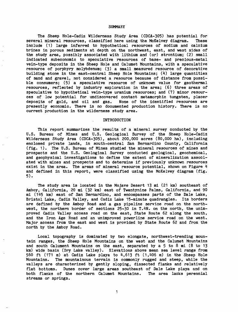
Table 1. Mines, prospects and mineral occurrences located in figure 3.
MapNo. Name Workings Resource Data
2. Prospeot
3. Mineral occurrence
4.. Prospect
5 Lucky Vim
6. Morgan Property
7. Sunshine- Alpha Area
8. Prospeot
9. Lost Weekend
10. Mineral occurrence
11. Prospect
12. Prospect
13. Queens Gold (Black Granite)
14. Disclaim 11
15. Highee
16. ML Placer
17. Placer prospect
18. Desert Rat Placer
19. f Tuborg *8 Placer
20. Good Grief
21. Rainbow Rock Quarry
22 . Sheep Hole #1 and 2
23. Quartz prospects
24. Dunite
25. Wild Joker Iron
26. Mineraloccurrence
Inclined shaft with drifts, four sand filled shafts; three pits, arraatra, head frame and miscellaneous foundations
One shaft and miscellaneous foundations
Claim cairns in vicinity
One pit
Mineral location
Three pits
Six pits
Two pits
Minor excavations
None
Minor excavations
One pit
Six pits and one adit
Minor excavations
Shallow shaft
One trenoh and a shallow shaft
One large pit
Mineral location
Mineral location
Two pits
Quarry
Mineral location and minor excavations
Minor excavations
Misoellaneoue excavations
Two pits
Minor excavations et two locations
Quartz vein N 55°-70°E, 45°-50° SW, 680 ft long, In sericitlcally altered granitic rock; miscel laneous mineralized zones. Twenty-four samples: twenty contained a trace to 0.182 oz gold/ton; ten contained 0.2 to 0.4 oz silver/ton, one contained 0.66 oz silver/ton; copper ranged from 0.01 to 0.02 percent in ten samples. Subeconomlo, identified resource - 65,000 tons containing 0.02 - 0.03 oz gold/ton.
Shaft through, overburden into rhyolite, metarhyolite and porphyroblastic metamorphic rooks. Three samples across dump: two contained 0.006 to 0.00? oz gold/ton; one contained 0.2 oz silver/ton.
Fault zone, N 85° E, 76° SE, with breooiated quartz and thin llmonite-clay zone. One sample 0.2 oz silver/ton.
Seven ft mineralized shear, N 75° E, 72° SE, with quartz, specularite and limonite in porphyro- blastio metamorphic rocks. Three samplee: one contained 0.008 oz gold/ton.
Intersecting shears, M 3° E, 37° SE, and M 10° E, 71° SE, with quartz and chlorite in granitic gneisa. One sample contained 0.01 percent copper.
Hornblende quartz diorite pendant intruded by quartz veins, N 40° E, 58° SE.
Two sets of quartz veins - N 10° W, SW dip and N 45°-65°, SW dip in granites of granodiorites. Nine samples: four contained a trace to 0.056 oz gold/ton; two contained 0.3 to 0.5 oz silver/ton; three contained 0.01 to 0.06 percent copper; four contained 0.01 to 0.08 percent lead; three contained from 0.02 to 0.15 percent zino.
Quartz vein and altered zone N 35° W, 72° NE. Four samples: one contained 0.006 oz gold/ton; one contained 0.2 oz silver/ton.
Alteration zone N 80° W, 61° NE.
Gossan zone in musoovite granite.
Quartz vein N 30° W, 76° NE intruding amphibolite pod in granodiorite.
Irregular gossans in granitic terrain.
Quartz vein NilO°-60°E, 25°-43°SE in altered granite with granodiorite gneiss enclaves. Seventeen samples: ten contained a trace to 0.034 oz gold/ton; six contained 0.2 to 0.4 oz silver/ton; five of sixteen contained 0.003 to 0.011 percent uranium.
Broad, llmonite-stained alteration zone N 40° W, 55° NE, with quartz and speoularite veinlets. One sample: 0.4 oz silver/ton.
On NE-trending gneiss to metaplutonio contact with secondary E-W and K 45° W shears. Two samples: one contained 0.008 oz gold/ton and 0.2 oz silver/ton; 0.01 and 0.06 percent copper and 0.01 percent zinc in both samples.
Fine to ooarse pebbly sand and silt with caliche layer. Two trench samples: one contained 0.000028 oz cu yd gold.
Reddish, unsolidated, fine sand with 0.5 ft caliche layer.
Alternating aeolian sand and caliche layers.
Fine dune sand and silt. One reconnaissance plaoer sample: 0.000046 oz/cu yd gold.
N 20° E, near vertical, friable, iron oxide stained zone at contact between granodiorite and foliated gneiss. One sample: 0.9 oz silver/ton and 5 ppm uranium.
Micaceous, hematite stained quartzite; fractures into 1 to 4 in.thick slabs, 0.5 to 2 ft in diameter; suitable for use as decorative stone. Estimated 2.100 tonsusable decorative stone and approximately 2,400 tons of decorative aggregate. Subeconomic.
Claimant has declined to answer inquiries for permission to examine the claims and publish the data.
N 20°-40° W, 45° ME to vertical, quartz veins to lenticular podsin granite, and granitic gneiss to metasediment contact zone. One E-W vertical pegmatite dike. Six samples: one contained 0.007 oz gold/ton; three contained 0.2-0.5 oz silver/ton; one contained 0.24 percent copper.
N 20° W, 45° SW, lenticular quartz veins in chloritieally altered gneiss.
Hornblende-epidote stringers and pods along N 10° E, vertical limestone-wollastonlte beds in schistose to gneissio metaaedlmentary rook assemblage.
Bedded schistose to gneissio metasediments with high epidote content. Two samples: 0.7 and1.4 ppm silver; 16 and 150 ppm copper; 11 and 17 ppm lead; 26 and 34 ppm zino; 11 ppm tungsten inone sample.
13

MapNo. Name
Table 1. Mines, prospeots and mineral occurrences located in figure 3 (continued).
Workings____________________ Hesource Data_____________________
27. S tear man
28. Mineral oocurence
Minor excavations at three
None
1) N 5° E, 60° NW, iron oxide stained shear in metasediments.2) Llmonlte stained bedding shear N 71° W, 52° SW, in quartzite pendant. One sample: 0.35 percent copper.3) Contact zone: medium-grained, hypabysaal intrusive and metasediments.
Llmonlte stained serioltlo alteration zone 15 ft wide, N 65° E, 65° NW; quartz veinlets. hematite, limonlte, pyrite in N 50° W, 49° SW Joints.
29 Dry LakePlacer Area
30. "Pediment" prospect
31. "Pediment" Mine
32.* Dale LakePlacer Area- JRM P laoers
33. Prospect
34. SheepWatsnew- Wlthera
35. Big Horn Mine
36. Wagner Mine
37. Sheep Hole Mine
38. Meadow
39- Boney
40. GreenSoor pi an Group
ill. Lost Sheep Gold
Six or more placer prospect pita
Two pita
One vertical shaft, one caved inclined shaft, one pit, mis cellaneous bulldozed strips
In excess of 65 baokhoe and bulldozer pits
Possible pit
Two pits, one drill hole
Three adits, five inclined shafts, and several pits and trenches
Three adits, one inolined shaft and five pits
Five inolined shafts, nineadits, one tunnel drift,five trenches, and 11 pits
One declined adit and one prospect pit
One pit
Five lode pits and one shallow inolined shaft; several small plaoer pits
One shallow shaft, four pits and minor excavations
Granitic to gneissio cobbles, pebbles, sand, and silt in pediment, basin fill, and playa terrain. Sediments are coarse and poorly sorted on pediments; playas commonly consist of finely laminated silt. Five of thirteen samples contained wet recoverable gold in the range of 0.000012 to a 0.001142 oz/ou yd.
N 30° W, vertical, 0.5 ft limonite stained quartz pods in 3.0 ft serioite gouge approximately serioite gouge approximately 40 ft long. One sample: 0.3 oz silver/ton.
Limonite-stained, breooiated shear zone in granitic country rook with calcite and manganese oxide coatings. Three samples: One sample contained 0.1 percent lead and 0.1 percent zinc.
Granitic, schistose and gneissio floodwash sediments in pediment to basin fill environments. Materials become finer to the west. Southern portion of this basin covered by sand dunes. Four of fourteen samples contained gold ranging from 0.000005 to 0.000228 oz/cu yd.
Wide, bleached to iron-oxide stained, possibly displaced gouge zone N 40° W, 60° SW; possible exposure to Sheep Hole Fault. Two samples: traoe gold and 0.001 percent mercury.
Hydrothermally-altered metasedimentary rook assemblage N 40°-70°W, 30°-70° SW, intruded by intermediate plutonio rocks. Uranium probably from late-stage magmatic solutions. Twenty samples: IkOg content ranged from 4 to 86 ppm and averaged 18 ppm.
N 45-65° W, 34-74° NE, hydrothermally altered and mineralized fault zone 2,500 ft long inin schistose to gneissio metasedimentary assemblage intruded by granite, aplite,alaskite and pegmatite dikes. Thirty-six samples: four contained 0.012 to 0.162 oz gold/ton;twenty-two contained 0.2 to 0.8 oz silver/ton and one contained 1.4 oz silver/ton; capper, lead,and zino ranged from 0.01 to 0.03 percent in six samples analyzed.
N 20°-70° W, NE dipping quartz-pegmatite veins in moderately to severely serioitioally altered granite; limonite after pyrite common. Thirty-four samples: one contained 0.19 oz gold/ton; twenty-three contained from 0.2 to 0.7 oz silver/ton. In fifteen samples analyzed for lead and zino, eight contained 0.01 to 0.02 percent lead and fifteen contained 0.01 to 0.04 percent zino.
N 45° W, 40°-75° NE, mineralized quartz veins along faults in quartz monzonite to granodiorite. Eighty samples: sixty-eight contained trace to 0.351 oz/ton gold; forty-one contained 0.2 to 1.6 oz/ton silver; several contained minor copper, lead, zinc and arsenic. Subeoonomlo identified gold resource estimated to be 165,000 tons containing 0.01 oz/ton.
N 45° W, 23-47° ME, hydrothermally altered gouge zone; approximately 780 ft outcrop. Four samples: three contained 0.011 to 0.050 oz gold/ton; two contained 0.2 to 0.27 oz silver/ton; one sample contained 0.08 percent zinc and 0.03 percent arsenic.
N 84° W, 67-74° SW, iron-oxide stained alteration zone 140 ft long in porphyrltio quartz monzonite. Two samples: one contained 0.8 ppm silver and 6 ppm copper.
Several quartz veins and pegmatite dikes with northwest strike and northeast dip in granodic rite-granite terrane. Twelve lode and ten plaoer samples: one contained 0.03 PP& gold; nine ranged from 0.0001 to 0.7 oz/ton silver; several contained small amounts of copper, lead, zinc, manganese, tungsten. Those samples analyzed for U^Og ranged from 3 to 71 ppm.
Quartz veins, N 26°-83° W, 25-70° NE, in porphyrltio granite, commonly with large limonite after pyrite and intense serioitio alteration; some comb quartz and large, brown oalolte crystals along walls. Fourteen samples: one sample contained trace gold; four contained 0.2 to 0.6 oz silver/ton; three ranged from 0.01 to 0.02 percent zino and 0.01 to 0.05 percent arsenic. Specimen collecting araa.
* actively held claims or leasee __ underlined properties are considered to have resource potential.
14

Calcium, sodium, lithium, and strontium occur in the large playas ad jacent to the study area. Brines rich in calcium and sodium chlorides are currently being produced from shallow wells drilled into the playas of Bristol and Cadiz Lakes, and sodium sulfate brines (and surface layers of thenardite Na2SOjj) formerly were produced from the playa of Dale Lake. Milling opera tions for current production are located in Amboy and Saltus, California.
The Conservation Division of the U.S. Geological Survey (198lb) consid ered lands contiguous to these lakes, including portions of the study area, to be prospectively valuable for sodium. Vertical Electrical Sounding resisti vity surveys (Hoover, 1982) suggest the presence of high-conductance layers at depth within the study area along the boundaries of all three saline lakes. The extent to which these may represent clay layers or deep crystalline salt horizons is unknown. However, the survey results suggest that substantial quantities of brines similar in character to those of the adjacent saline lakes are present at depth in basinal areas within the wilderness study area (fig. 4, B-l, B-2, B-3). The easiest production of such brines is likely to be by pumping from the playas outside the study area. Most of the wilderness study area is elevated with respect to the dry lakes and is less favorable for pumping and development of evaporating ponds. Therefore, while the brine resources discussed here probably exist within the wilderness study area, any production of these brines most probably would occur from locations outside the area. Layers of crystalline salt and layers containing strontium or lithium could exist in any of the areas identified to have potential for saline brines.
Area B-1 The companies operating on Cadiz Lake pump calcium chloride from a production zone at a depth averaging 200 ft (60 m) from at least 10 wells, and concentrate the brines at five evaporation pond complexes. One operator produces 1,000 to 1,250 tons (900 to 1,130 t) per month of calcium chloride brine with a specific gravity of 1.6 (Calzia, and others, 1979). Based on drill hole data, Calzia and others (1979) determined that a near-surface, 3 ft to 12 ft (0.9 to 3.7 m) thick, massive, crystalline salt bed exists at Cadiz Lake. The resource is calculated as ranging from 31,000,000 to 112,500,000 tons (28,000,000 to 102,000,000 t) of salt, assuming the composition of the bed is 100 percent NaCl with a density of 134.7 Ibs/cu ft (2.2 g/cu cm). Water quality data from several wells on Cadiz Lake (Calzia and Moore, 1980) indicate high calcium and sodium values and anomalous concentrations of lith ium and strontium in the brines. Uranium concentrations are too low to be of economic interest at this time (Calzia and Luken, 1981, p. 12).
The wilderness study area includes a small, nonproducing portion of Cadiz Lake. Commercial brines are not likely to occur near the surface in this portion or elsewhere within the eastern side of the study area, as indicated by two factors: (1) a fresh-water well 300 ft (91 m) deep in sec. 20, T.3N, R.15E. on Cadiz Lake, and (2) decreasing values of calcium, sodium, and potas sium in Cadiz Lake brines away from the near-surface salt beds, which lie outside the wilderness study area. However brines are inferred at depth within the wilderness study area based on the geophysical data.
In estimating the areal extent of this resource in the Sheep Hole-Cadiz Wilderness Study Area, criteria were established and using these criteria, area B-1 (fig. 4) was derived. The criteria were based on gravity, magnetic, and geoelectrical (vertical electrical sounding, and audio-magnetotelluric)
15

R12E
M-2-;^-M-i
Figure 4. Mineral-resource potential map of the Sheep Hole- Cadiz Wilderness Study Area
16

ECONOMIC
MARGIN -ALLY
ECONOMIC
SUB- ECONOMIC
IDENTIFIED RESOURCES
Demonstrated
Measured
Size, shape depth and
mineral content of
the resource are well
established.
Indicated
Size & grade of resource is establish ed with less assurance
than for 'measured'.
i
Reserves
j
Marginal Reserves
I |
Demonstrated Subeconomic
Resources
Inferred
Assumed continuity beyond reserve base for which
there Is geologic evidence.
Inferred Reserves
Inferred Marginal Reserves
Inferred Subeconomic
Resources
UNDISCOVERED RESOURCES
HypotheticalResources more
likely to be present.
Geologic conditions similar to producing
mineral bodies in the same
district or region.
SpeculativeResources less
likely to be present.
Geologic setting is favorable for deposits.
, ->-
Figure 5. Classification of resources (after U.S. Bureau of Mines and U.S. Geological Survey,1980)
17

studies. The results of these studies show that sedimentary fill exceeds 1000 ft (300 m) thick and contains thick zone(s) of extremely low electrical resistivity (1/2 to 1 ohm-meter). The zones are estimated to be 590 ft (180 m) deep in the north to 2950 ft (900 m) deep on the south. The low resisti vity extends throughout area B-1 and continues eastward into the Cadiz Lake playa. The resistivity values and their spatial distribution are interpreted to result from the presence of porous sediments saturated by highly saline (on the order of 250,000 ppm total dissolved solids) brines. The composition of such brines is presumed to be similar to those currently produced from Cadiz Lake playa and, therefore, they probably contain resources of calcium and sodium chlorides as well as lithium and strontium. Crystalline salt layers may also persist from beneath the playa into area B-1. Area B-1 is considered to be an inferred resource as defined by the U.S. Bureau of Mines and U.S. Geological Survey (fig. 4).
Area B-2 Wright and others (1953, P- 220) cite the average composition of the deposits in Dale Lake as 60 percent Na2SO^, 30 percent NaCl, and 10 percent insoluble constituents, and the brines as 7.5 to 8.0 percent Na2SO^ and 20.0 to 22.0 percent NaCl. Besides a surface thenardite deposit, borings have disclosed two buried zones, a 30 ft (9m) zone beginning at depths of 20 to 40 ft (6 to 12 m), and a 100 ft (30 m) zone beginning at about 120 ft (37 m) deep. Lithium analyses at five-foot intervals in a test well (J. P. Calzia, personnal communication, 1981) ranged from 5 to 178 ppm. The southeast corner of the playa is included in a tract clasified as "lands valuable (known) for sodium" by the Conservation Division of the U.S. Geological Survey (198lb). Based on an estimated density of 136 Ibs per cu ft (2.2 g/cu cm) and the given thickness of deposits, Calzia and others (1979, p. 146) calculated the indi cated sodium resources of the known valuable area as 21,300,000 tons (19,300,000 t) and 71,700,000 tons (65,000,000 t) within the upper and lower zones, respectively. Seismic evidence (Simpson and others, 1982) indicates the basin is 5,000 to 6,000 ft (1,500 to 1,800 m) deep and elongated in an east-west direction; the deepest point is below the east end of the playa. The inferred areal extent of the Dale Lake brine deposits in the southwestern part of the Sheep Hole-Cadiz Wilderness Study Area is shown as area B-2 (fig. 4).
The criteria for establishing area B-2 are gravity, magnetic, and geo- electrical studies which show that sedimentary fill exceeds 1000 ft (300 m) in thickness and contains thick zones (250 to 450 ft) (76 to 120 m) having ex tremely low electrical resistivity (1/2 to 1 ohm-meter), which continue west ward and southward into Dale Lake playa. These data are interpreted to result from the presence of porous sediment saturated by highly saline brines. Such brines are presumed compositionally similar to the thenardite- plus halite- bearing brines previously produced from Dale Lake playa. Lithium may also be present in the sediments within B-2. Area B-2 is considered to be an inferred resource.
Area B-3 Bristol Lake brines are rich in calcium and sodium and, as Durrell (1953, p- 9) noted, contain sufficient strontium on the west side to precipi tate celestite (SrSO^) concretions. Various salt beds have been reported at depth in even the deepest test wells (1,007 ft 307 m ,Bassett and others, 1959). Calzia and others (1979, p. 124) have estimated the indicated surface and near-surface salt resources as 26,100,000 tons (23,700,000 t) at 75 per cent NaCl.
18

In estimating the areal extent of the Bristol Lake brines in the north western part of the Sheep Hole-Cadiz Wilderness Study Area area B-3 (fig. 4) was derived. The criteria for establishing area B-3 are gravity, magnetic, and geoelectical (vertical electrical sounding and audio-magnetotelluric) data that reveal a basin in which sedimentary fill is at least 1000 ft (300 m) thick and contains a thick zone (up to 1100 ft) (335 m) having low electrical resistivity (10 ohm-meter) along its northern margin. The presence of saline brines is strongly suspected. Near-surface sediments in this basin are prob ably continuous with sediments in the Bristol Lake basin; however, deeper sediments may be separated from the Bristol Lake basin by a buried basement ridge. Chemistry of the suspected brines is presumed similar to the sodium and calcium chloride and strontium-bearing brines of Bristol Lake playa. Area B-3 is considered to be a hypothetical resource.
Base and Precious Metals
Many of the mines, prospects, and areas of mineralized rock in the study area are associated with contact zones of the Cadiz Valley batholith of Cretaceous age where it intrudes Proterozoic, Paleozoic, and Jurassic meta- igneous and metasedimentary rocks. The mineralized zones are characterized as fissure-filling quartz veins containing pyrite, calcite, barite, manganese minerals, minor gold and silver, and traces of chalcopyrite, chrysocolla, malachite, galena, sphalerite, and molybdenite, although not all are present at all localities. Alteration nearest the vein is predominantly phyllic with subordinate argillic zones; pyrite is commonly weathered to limonite. Mineralized zones are structurally controlled by joints, shears, and faults along the boundaries of plutonic rocks, and by local shears and bedding planes intruded by dikes within older basement rocks; the predominant trend of these structures is northwesterly.
Six areas (fig. 3, M-1, M-2, M-3, M-4, M-5, M-6) in the Sheep Hole-Cadiz Wilderness Study Area are considered to have potential for base and precious metals. Five of these areas are associated with or are proposed extensions of known mining or prospected areas. A sixth area in the south Calumet Mountains (fig. 4, M-5) is a previously unknown mineralized area that may have poten tial.
Area M-1 The Sheep Hole Mine and Big Horn-Wagner properties lie in a resource area designated M-1 (fig. 4).
The Sheep Hole Mine (fig. 3 and table 1, no. 37) has been intermittently claimed and operated since 1917 but is not known to be actively held at this time. Thirty-four workings, an old arrastra, millsite foundations, and sev eral other abandoned facilities are on the property. Workings consist of nine adits totaling 270 ft (82 m), five shafts, a 47 ft (14 m) tunnel, five trenches totaling 413 ft (126 m), and fourteen pits. Most of the workings are along two prominant, northwest-striking, northeast-dipping mineralized fault zones. The mineralization consists of massive to sheared, milky white quartz veins with limonite after pyrite, limonite and hematite staining, minor sphal erite and chalcopyrite, and occasional galena and magnetite. Thin-section and polished section observations indicate that chalcopyrite and galena cystalli- zed first followed by pyrite and finally sphalerite. Sericitic alteration is present throughout the mineralized zones, in country rock proximal to the faults, and along some joints. Chloritic and minor argillic alteration and interfingered earthy limonite layers are also found in gouge zones along the
19
main faults. Several small quartz veins, similar to those found in the main fault zone, occur along joints and minor shear zones. No widespread limonitic alteration was detected in this area but samples of the chloritic and argillic (propylitic?) alteration indicate a base metal suite of copper, lead, zinc, and silver mineralization.
Of 80 samples taken on the property, gold ranged from trace to 0.351 oz/ton (12.03 g/t) in 68 samples, silver ranged from 0.2 to 1.6 oz/ton (6.9 to 54.9 g/t) in 41 samples, and several contained low levels of copper, lead, zinc, and arsenic. Exposures of the mineralized zones can be traced for 2,100 ft (640 m) along strike with 330 ft (100 m) of relief. Subeconomic indicated and inferred resources of approximately 165,000 tons (150,000 t) are calculated, at an average grade of 0.01 oz gold per ton (0.34 g/t). This property is considered to have potential for relatively small, high-grade gold and silver deposits.
The history of development of the Big Horn-Wagner properties (fig. 3, and table 1, nos. 35 and 36) is not known. The Big Horn Mine was not actively held at the time it was examined, but the Wagner Nos. 1-3 claims were held by Mr. and Mrs. Codding. Workings on the Big Horn consist of three adits total ing 441 ft (134 m), four shafts totaling 82 ft (25 m), two trenches, and five pits. Three adits totaling 100 ft (30 m), one 18 ft (5 m) inclined shaft, and five pits are developed on the Wagner Nos. 1-3. Both mines are on a mineral ized fault zone which strikes N 45°-65° W, and dips 34°-74° NE. The fault zone consists of friable to silicified limonite-stained clay and sericite gouge associated with veinlets and brecciated veins of quartz up to 5 ft (1.5 m) thick. The zone can be traced for approximately 3,800 ft (1,160 m) along strike. At the Big Horn property, the same structure occurs in a transitional contact zone between schistose to gneissic metasedimentary rocks and intrusive granodiorite associated with ptygmatically folded aplite, alaskite, and pegma tite dikes. On the Wagner Nos. 1-3, to the northwest, the fault cuts only porphyritic granodiorite and appears to feather or horsetail and die out. Slickensides at this locality indicate the latest movement was vertical.
Of 70 lode samples taken from the properties, five contained 0.012 to 0.19 oz gold/ton (0.41 to 6.5 g/t) and 46 contained 0.2 to 1.4 oz silver/ton (6.9 to 48.0 g/t). Low levels of lead and zinc were also detected. Semi- quantitative spectrographic analyses of the lode samples reveal pervasive, low levels of copper and persistent, anomalous molybdenum values, both of which decrease northwesterly. The Big Horn and Wagner properties are currently classified as subeconomic; however, there is potential for discovery of small gold and silver vein deposits. There is also speculative potential for por phyry molybdenum.
The Big Horn and Wagner mines occur in a limonitic zone, characterized by argillic alteration interpreted as resulting from hydrothermal alteration and mineralization along the mineralized fault. Many of the concentrate samples are weakly anomalous in bismuth, molybdenum, beryllium, tin, and tungsten suggesting a magmatic mineral suite commonly associated with porphyry molyb denum type deposits. A large limonitic zone is identified in this area from LANDSAT images, and rock samples indicate a suite of molybdenum, copper, and silver with minor bismuth. Limonitic coatings obtained from concentrate samples from the along the front of the range downstream from Sheep-Watsnew- Withers group of claims area are also anomalous in molybdenum, copper, and
20
silver. The trace element suites from these areas suggest two mineralizing events, one associated with the magmatic suite of molybdenum, bismuth, beryl lium, tin, and tungsten, and a later one associated with base metals, copper, lead, zinc, and silver.
Minor gold and silver along the contact between the Cadiz Valley bath- olith and older basement rocks at the Big Horn and Wagner Mines (fig. 3 and table 1, nos. 35 and 36) contrast with a varying amount or absence of such elements at mines progressively farther away from the contact (Sheep Hole, Boney, Green Scorpian, and Lost Sheep Gold properties fig. 3 and table 1, nos. 37, 39, 40, and 41). Molybdenum and bismuth are present in highly anom alous amounts in rock samples collected from the Big Horn-Wagner area with lesser amounts of beryllium and trace amounts of tungsten. Although these concentrations may represent contact phenomena, this elemental suite is pres ent, with tin, in concentrate samples throughout the Sheep Hole Mountains (Marsh and Raines, 1982) and may be the result of a mineralizing feature of the Cadiz Valley batholith and (or) Jurassic porphyritic granite. This geo- chemical suite is suggestive of porphyry molybdenum mineralization although no definitive indications of this type of mineralization were seen in this study.
Several criteria were used to define the areal extent of area M-1 (fig. 4). The criteria were (1) several old mines including The Big Horn- Wagner properties and the Sheep Hole Mine having probable past production and known to contain values in gold, silver, lead and zinc; (2) argillic and sericitic alteration occurring in the vicinity of mineralized structures; (3) anomalous values of silver and copper detected in the nonmagnetic fraction of panned concentrates from stream sediments; and (4) geologic terrane favorable for base and precious metal mineralization along faults cutting metasedi- mentary rocks intruded by the Cadiz Valley batholith. Area M-1 is classified as a subeconomic indicated and inferred resource for precious metals and is considered to have potential as a speculative resource of molybdenum.
Area M-2 This area (fig. 4) is an extension of area M-1 and although no mines exist within the area and no known mineral deposits are present, several criteria define M-2. The criteria used were a continuation of the same favor able geologic environment (Sheep Hole fault system, contact of granodiorite with country rock) and the presence of slightly anomalous values of barium, silver and copper detected in the nonmagnetic fraction of panned concentrates from stream sediments. Minor mineralization in older Quaternary alluvium exposed at an unnamed prospect (fig. 3, no. 33) is evidence of recent hydro- thermal activity. Area M-2 is considered as a hypothetical resource of base and precious metals.
Area M-3 Area M-3 (fig. 4) contains the Sunshine-Alpha prospects (fig. 3 and table 1, no. 7), which consist of six pits within a one sq mi (2.6 sq km) area. Country rock is characterized as a gray to buff colored, moderately weathered, two-mica granite to granodiorite of the Cadiz Valley batholith. The pits expose two sets of mineralized quartz-pegmatite veins and lenticular quartz pods, oriented N 10° W, 47°-60° SW and N 40°-60° W, 45°-88° SW, found in the area. The latter set crosscuts a N 10° W, 85° SW set of aplite dikes. Several dacite dikes of Tertiary age intrude the country rock. Quartz vein mineralization consists of pyrite, limonite after pyrite, and minor chalco- pyrite altering to red limonite, chrysocolla and malachite. Intense sericite- rauscovite wallrock alteration, as well as moderate limonite, is commonly
21

associated with the quartz veins. Many of the quartz veins are brecciated and recemented. Based on strike directions and cross-cutting relationships, there is evidence in the Sunshine-Alpha area of at least two episodes of minerali zation; the presence of Tertiary dacite dikes in the area suggest the possi bility that the latest may be associated with them.
Four of nine chip or grab samples of quartz veins ranged from trace to 0.056 oz gold/ton (1.92 g/t) and two contained 0.3 and 0.5 oz silver/ton (10.3 and 17.1 g/t), while some samples contained minor amounts of copper, lead, and zinc. The nine rock samples of quartz veins were analyzed by a semiquanti- tative spectrographic technique (Grimes and Marranzino, 1968) and highly anomalous amounts of silver, beryllium, bismuth, copper, and molybdenum were found with minor amounts of lead, zinc, and tungsten. This assemblage of elements apparently represents two suites: (1) a base metal suite of copper, lead, zinc, and silver, and (2) a magmatic suite of beryllium, bismuth, molyb denum, and tungsten which is commonly associated with porphyry molybdenum systems. Semiquantitative spectrographic analysis of non-magnetic heavy min eral fractions of panned concentrates of stream sediments indicate above background values for molybdenum, barium (as barite), and strontium.
In defining the areal extent of M-3 several criteria were used: (1) the presence of peraluiminous granite to granodiorite of the Cadiz Valley bath- olith injected by quartz and pegmatite veins associated with intense sericite- muscovite alteration and local limonitic staining, (2) intrusion by dacite dikes possibly associated with quartz veins, (3) stockwork veins that contain gold, silver, copper, lead and zinc as well as highly anomalous concentrations of molybdenum (10 to 1500 ppm) and bismuth (50 to 5000 ppm), and (4) the nonmagnetic fractions of panned concentrates from stream sediments contain high molybdenum and barium and selected rock samples are highly anomalous in silver, bismuth, beryllium, copper and molybdenum. Area M-3 is considered to have potential for small-tonnage gold deposits, and is classed as a hypotheti cal resource of gold. Although conclusive data are lacking, the rock type, mineralization, and alteration characteristics in area M-3 resemble those described by Westra and Keith (1981) for molybdenum stockwork deposits asso ciated with calc-alkaline magma systems. Area M-3 is considered to have potential as a speculative resource for molybdenum.
Area M-4 Area M-4 surrounds area M-3 and represents a less well defined extension of the mineralization found in M-3. The Aljac Mine (previously known as the Calmont or Calumet Mine, fig. 3 and table 1, No. 1) lies on an extension of area M-4 and lies approximately one mile (1.7 km) north of the boundary of the wilderness study area. The mine is currently held by John Cooley and Al Mendel, Jr., who are improving access and evaluating mineralized zones. The main working consists of a 150 ft (46 m) inclined shaft with 140 ft (43 m) of drift on a prominant, 1 to 1.3 ft (0.3 to 0.4 m)-wide, 680 ft (207 m)-long mineralized quartz vein oriented N 55°-80° W,/dipping 45°-50° SW. Other developments on the property include three sand-filled shafts, four pits, several foundations, and the remains of a 48 in. (122 cm) diameter arrastra. The vein is milky white quartz and contains gold, pyrite, and sphalerite; limonite banding and sparse chrysocolla and manganese oxide en crustations are found in the alteration zone. Wide bands of intensely serici- tized and slightly chloritized country rock border the quartz vein.
22

Twenty of twenty-four samples contained trace to 0.182 oz goId/ton (6.24 g/t). Based on an average width of 3.3 ft (1.0 m) for seventeen samples and a minimum depth of 160 ft (49 m), it is estimated that the main structure con tains an indicated plus inferred subeconomic resource of 65,000 tons (59,000 t) containing 0.02 to 0.03 oz gold/ton (0.69 to 1.03 g/t). Sampling of other structures (fig. 3 and table 1, Nos. 2-4) exposed on the property indicates potential for hypothetical resources of vein gold deposits.
The areal extent of M-4 was determined using the following criteria; (1) country rocks and geologic environment similar to that of area M-3 and (2) anomalous barium and molybdenum in the nonmagnetic fraction of panned concen trates from stream sediments. Area M-4 is considered a speculative resource for potential base- and precious-metal vein deposits.
Area M-5 A large (approximately 35 sq miles 90 sq km) area of iron- metasomatic hydrothermal alteration was identified in the south Calumet Mountains (M-5, fig. 4). The term iron metasomatism is used in the context of Goldschmidt (1922), Mason (1966), and Gary and others (1972) and is defined as incipient alteration that is indicative of the past presence of interstitial, chemically active pore liquids or gases contained within the rock body or introduced from external sources. Critical minerals are limonite and(or) local pyrite coatings with anomalous trace elements. In area M-5 the term iron metasomatism is used to describe rocks with limonitic and occasional pyritic coatings along horizontal joints in a two-mica granite. Sediment sampling suggests these coatings contain anomalous trace elements, and may represent fluids residual from the formation of the granite; the coatings are considered indicative of potential mineralization in the area.
Stream sediment and concentrate sampling in the area show an increase in rare earth content (lanthanum, yttrium, and thorium) and a decrease in the molybdenum, bismuth, tin, tungsten, beryllium suite going from the granitic rocks of the Sheep Hole Mountains to the granitic rocks of Calumet Mountains. This is consistent with the increasingly silicic character of the granitic rocks going eastward from the Sheep Hole Mountains to the granitic rocks of the Calumet Mountains.
Granite in area M-5 is stained with iron oxides. Field reconnaissance and geochemical results indicate that the iron oxides were not generated from the weathering of mafic minerals, that they seem to be related to only one of the three joint systems in the area (strike N 50°-70° W, dipping 18° S), and that rocks containing them are weakly anomalous in silver, lead, and barium. To further investigate and define this area iron and manganese oxides were analyzed to see if they contained anomalous concentrations of metals absorbed by these compounds. The intermediate magnetic fraction of the concentrate samples was used for this investigation as this fraction contained adsorbed iron and manganese oxides on sediment from the representative drainage basins. The iron and manganese oxides were dissolved from the samples using hot aqua regia and were analyzed using the induction coupled plasma spectro- graph (Church, 1981, Church and others, 1982). The results from this investi gation revealed anomalously high amounts of arsenic, bismuth, cerium, lan thanum and molybdenum with minor amounts of copper, lead, zinc, and silver. It appears that although the suite of molybdenum, bismuth, tin, tungsten, and beryllium is not evident as discrete minerals in the non-magnetic fraction of the concentrates from this limonitic zone, it is in places present with base
23

metals and rare earths in the iron and manganese oxide fraction and may repre sent leakage of mineralization from depth. Several major NNW-trending faults that cut the area possibly provided a conduit system for the observed mineral ization. The suite of elements seen in the samples is a common one found in most two-mica granites. The suite is, however, enhanced in concentration here and may represent concentrations of metals related to a mineralizing system. Some of the possible systems are base-metal veins, porphyry molybdenum, skarn, or tin granite.
The area roughly coincides with an aereomagnetic low and quiet area part of which is coincident with a gravity low over exposed granitic basement. This configuration possibly could be caused by hydrothermal alteration of a substantial thichness of material. An audio-magnetotelliuric (AMT) sounding on the west side of the area revealed low resistivity (100 ohm-meter), which may indicate alteration, to depths near 3000 ft (1 km). An aeroradiometric anomaly in uranium is observed in the north-central part of area M-5 (J. K. Otton, written commun., 1981).
The principle criterion used in delineating area M-5 (fig. 4) is the large limonitic area identified on the LANDSAT imagery. Other criteria are the interpretation as alteration by iron metasomatism, a roughly coincident aeromagnetic low, a single sounding indicating low resistivities, and geo- chemical data from stream sediments and panned concentrates from stream sedi ments. The existence or type of deposit represented cannot be determined from the available evidence, and the area is classified tentatively as a specula tive resource. The confidence that mineral deposits occur is low.
Area M-6 An area of prospects in the southern portion of the south Calumet Mountains (fig. 3 and table 1, no. 13) contains the Black Granite Claims located in 1955, the Golden Cross Group located in 1973, and the Queens Gold Group, located in 1980 (Area M-6, fig. 4). The terrane is low hills and pediment exposing weathered granite and numerous contained enclaves of dark granodiorite gneiss, in or near a suspected fault zone. The granite is in places slightly to intensely sericitized to argillized, with or without asso^ ciated quartz veins. The workings include a 20-ft (6-m) adit developed on a northeast-trending quartz vein system, and small pits in altered granite and granodiorite gneiss. Of seventeen samples taken from the workings, 10 con tained a trace to 0.034 oz go Id/ton and 6 contained 0.2 to 0.4 oz silver/ton. No copper was detected in 11 samples analyzed. The main north east-trending quartz vein is 185 ft long and averages 2.4 ft thick at less than 0.01 oz gold/ton too small for a resource calculation. The presence of gold in altered granite, and in limonite-altered gneiss enclaves near the quartz vein system, suggests the possibility that the gold is part of a desseminated system. There is no apparent potential for silver or copper. The area is considered to have low to moderate potential as a hypothetical vein gold and speculative disseminated gold resource (fig. 4, area M-6).
Placer gold Sixty-eight reconnaissance and trench placer samples were taken from the Sheep Hole-Cadiz Wilderness Study Area. Gold in amounts as high as 0.001 oz/cu yd (0.0002 to 0.0464 g/cu m) was recovered from eighteen of the samples. Fourteen of these sites are in deposits derived from the Sheep Hole Mountains, two are in deposits probably originating in the Pinto Mountains, and two are in deposits derived from the west-central Calumet Mountains. Factors which tend to inhibit recovery of placer gold in the study area In-
24

elude its small particle size, spotty occurrence, low grade, and the presence of moisture (which precludes the use of dry placer recovery methods). Based on this limited study, placer gold has very low or else no apparent potential as a resource.
Skarn tungsten The local presence of carbonate-bearing metasedimentary rocks intruded by silicic granitoid bodies of the Cadiz Valley batholith in the central and northern Sheep Hole Mountains and the presence of anomalous tung sten in the nonmagnetic fraction of panned concentrates from stream sediments suggests a potential for skarns with small or poorly exposed concentrations of tungsten. Of the 30 concentrate samples collected from this area, 17 con tained from 10-300 ppm tungsten. Tungsten was also detected in several of the workings in the northern Sheep Hole Mountains. Although no skarns were mapped in this study, evidence suggests that skarns may exist in the central and northern Sheep Hole Mountains. The potential does not warrant classification as a tungsten resource.
Portions of the alluvial area surrounding and within the Sheep Hole Mountains are considered to have very low potential for economic concentra tions of placer scheelite (tungsten). Placer accumulations of tungsten have not been demonstrated to exist in the area; however, sediments occurring down from any contact metamorphic tungsten deposits have some slight chance of containing deposits of tungsten.
Rock Products
Voluminous deposits of common borrow, sand and gravel including quartz dune sand are present in the study area. Because of the low bulk value of the commodity and the high transportation costs involved in shipping to distant market areas, there is no apparent potential for development of these deposits in the foreseeable future other than for small local uses.
Area D-1 A small source of decorative stone, named the Rainbow Rock Quarry, was developed in the 1950's or early 1960's on the east slope of the central Sheep Hole Mountains (sec. 26, T. 1 N., R. 13 E.), (fig. 3 and table 1, no. 21; fig. 4). Developments consist of a loading ramp, a structure found ation, a staging and turn-around area, and two mine haulage roads cut across the west facing dip-slope of the deposit. The source of the stone is a rough ly rectangular body 100 ft (30 m) long with a wedge shaped cross-section 8 ft (2.4 m) thick at its thickest point. It is composed of a foliated, meta- quartzite enclave or roof pendant with foliation oriented N 45° W, 40° SW. Well defined, subparallel, micaceous partings at one to three inch (2.5 to 7.6 cm) intervals, allow the rock to be ripped or split into tabular, polygonal plates suitable for use as decorative veneer. Based on field surveys, a specific gravity of 2.55, and an estimated useability factor of 60 percent, the net measured decorative stone resource is calculated to be 2,100 tons (1,900 t) with a coverage factor of 72 sq ft/ton (7.4 sq m/t) for 2 in. (5 cm) thick stone. An additional 2,400 tons (2,200 t) have potential as crushed decorative aggregate. The deposit is small and is far from any known market, rendering the product subeconomic. However, the resource may be suitable for a single large project such as a commercial or public building, and is there fore considered to have potential. It is classed as a subeconomic measured resource.
25

Geothermal Resources
The Sheep Hole-Cadiz Wilderness Study Area is located astride the bound ary between the Mojave and Sonoran tectonic blocks (Fuis, 1981). The origin of the tectonic boundary is unknown, but its existence is indicated by a north-northwest trending asymmetric ridge on the mantle (Fuis, 1981), an eastward decrease in seismicity (Alien and others, 1965), and an eastward increase of crustal heat-flow (Lachenbruch and others, 1978).
Preliminary interpretation of U.S.G.S. heat-flow data obtained in 1977 and 1979 over the Mojave Desert region indicates a north-northwest trending region of moderate to high heat-flow (about 100 mw/nr) that includes Cadiz Valley and the eastern portion of the study area (P. S. Galanis, written commun., 1982). No surface manifestations of geothermal activity are known in the study area except in older Quarternary alluvium at an un-named prospect (fig. 3 and table 1, no. 33) on the Sheep Hole fault where hydrothermal acti vity is indicated by minor mineralization in Quaternary alluvium. Further, the U.S.G.S. data do not allow a detailed evaluation of the geothermal re source, both because the data points are widely spaced (about 30 km), and because of the effects of complex hydrology. These hydrolpgic effects are reflected by differences of heat flux as great as 100 mw/nr in sites 25 km apart. Geothermal potential throughout the region of the wilderness study area is supported by regional heat flow values.
Area G-1 In 1981, several shallow geothermal gradient holes were drilled in and near the study area by the Geothermal Division of Phillips Petroleum. According to Phillips-Geothermal, this exploration was followed by a second phase of confirmation drilling in two areas pertinent to the Sheep Hole-Cadiz Wilderness Study Area: 1) between Dale Lake and the Sheep Hole Mountains, and 2) along the southwest side of Cadiz Valley. Lease applications were filed by Phillips-Geothermal in June 1981, for lands along the southwest side of Cadiz Valley; evidence motivating the second phase of drilling and data from com pleted holes is held in confidence. As of September, 1982, industry activity in the area has ceased. Criteria used for establishing area G-1 (fig. U) were the fact that the area is being evaluated by and is under lease application by a major geothermal exploration company and that the area is within a large north-south trending zone of high but variable heat flow, as determined by the U.S.G.S. during ongoing regional studies of heat flow. Based on the above criteria the area within the Sheep Hole-Cadiz Wilderness Study Area along the southwest side of Cadiz Valley is considered as a speculative resource for geothermal resources of undetermined potential. A low-temperature hydro- thermal convection system, if present, might be suited for direct applications in space heating, agriculture and industry (Mohorich, 1980).
Uranium
Hypothetical or speculative resources of vein-type uranium are identified in three areas: U-1, U-3, and U-3« Alluvial fans downstream from these areas are possible locations for uranium placers.
Area U-1 Recent uranium exploration by private industry is documented by claim locations in unsurveyed sections 27, 3^, and 35, T. 2 N., R. 12 E., S.B.M. The Sheep-Watsnew-Withers Group of at least 2U claims occur in area U- 1 (fig. 4) in the northwest end of the Sheep Hole Mountains (fig. 3 and table
26

1, no. 3*0. The Watsnew Claims were located in 1972, and the American Copper and Nickel Company located the Sheep Claims in the area in 1978. The Wither Claim(s) was probably located subsequent to the Sheep Claims. No active holdings are known in the area and there is no evidence nor record of produc tion. Two prospect pits were excavated on the discoveries in 1972. American Copper and Nickel Company conducted limited geophysical and geochemical sur veys, and drilled one exploratory hole in 1979. Aeroradiometric data obtained under the National Uranium Resource Evaluation (NURE) program (Geodata International Inc., 1979) indicate uranium twice background values, potassium twice background, and thorium 1.5 times background for a flight line across area U-1 (J. K. Otton, written commun., 1981).
Rock units in the vicinity of the claims are biotite schist, gneiss, and quartzitic metamorphic rocks injected with ptygmatically folded aplite dikes and bounded by granite and granitic gneiss. Sparsely mineralized deposits are restricted to propylitically altered, red to purple, boudin-like outcrops of the metamorphic assemblage. The outcrop pattern is elongate in a N 50° W direction in two, subparallel, discontinous lensoid bodies 4,000 to 5,000 ft (1,200 to 1,500 m) long. Foliation, shears and alteration zones strike N 40°- 70° W and dip 30°-70° SW. The more intensely propylitically altered zones occur in association with aplite dikes, are gossan-like in appearance, and contain limonite after pyrite, although pyrite and arsenopyrite are commonly visible.
These prospects occur in part of the limonitic zone identified from LANDSAT images in the vicinity of the Big Horn and Wagner Mines. Samples of limonitic altered rocks indicate that this area is related geochemically to the fault zone and propyllitic alteration at Big Horn and Wagner mines, be cause the geochemical suite of molybdenum, copper, and silver with minor bismuth typical of these deposits was present in most samples taken. Five scintillometer traverses registered counts 2 to 2.5 times above background over interfingered metamorphic and plutonic rocks. The association of aplite dikes with altered, mineralized zones and anomalous uranium suggests late- stage plutonic origin and the uranium and thorium probably were derived from late-stage magmatic fluids which evolved from the Cadiz Valley batholith. Later hydrologic and (or) thermal events may have resulted in a redistribution of the uranium. Twenty samples were taken on the properties. Uranium content in 18 samples ranged from 4 to 86 ppm and averaged 18 ppm U^Og. Excluding three anomalously high samples (33, 73, and 86 ppm), the remaining analyses ranged from 3 to 15 ppm and averaged 8-9 ppm UoOg. These are little more than background uranium contents in altered granitoid rocks of the Cretaceous suite (1-6 ppm) and the Jurassic suite (0-6 ppm) from throughout the study area.
The criteria used in delineating area U-1 (fig. 4) are: (1) Spotty, low- grade uranium mineralization along faults in and near the batholithic contact with older metasedimentary units, (2) eighteen of twenty rock samples having an average of 18 ppm uranium, (3) mineralization and alteration that is spa tially associated with the uranium mineralization includes gossan-like zones of limonite after pyrite with pyrite and arsenopyrite commonly present, and (4) data from ground and airborne radiometric surveys that indicate the pres ence of anomalous uranium. The relatively low grade, irregular distribution, and discontinuous nature of mineralized zones make a resource estimate im practical. This property is considered to have low potential as a hypothet ical resource of uranium.
27

Area U-2 A 2 sq mile (5 sq km) area in the west-central Sheep Hole Mountains (fig. 3) contains potential as a speculative resource for uranium and thorium. Delineation of this area was based on a NURE aeroradiometric anomaly in uranium (J. K. Otton, written commun. 1981) and anomalous thorium in the nonmagnetic fraction of panned concentrates from stream sediments. A north west-trending fault system favorable for development of vein and replacement deposits is present, as are igneous rocks potentially suitable as source rocks. These rocks are propylitically altered over a substantial area, and limonitic coatings occurring on the intermediate fraction of panned concen trates from sediments contain anomalous cerium and bismuth suggesting an origin related to fluids of magmatic origin.
«Area U-3 A one-square mile (2.5 km ) area in the south part of the southern Calumet Mountains (Area U-3, fig. 4) contains the Queens Gold Group of claims (fig. 3 and table 1, no. 13). Uranium commonly occurs with intense limonite alteration associated with pegmatite dike swarms in enclaves of granodiorite gneiss in the granite. The nature of the uranium occurrence resembles that of the Sheep-Watsnew-Withers deposit (Area U-1, fig. 4). Five of 16 samples analyzed for uranium ranged from 0.003 to 0.011 percent uranium (plus 1 value of 5 ppm U^Og) and 3 of 15 samples contained 0.003 to 0.004 percent thorium. Observed deposits containing uranium and thorium are too small and spotty to be economic; however, the area has low potential for discovery of larger deposits of a similar nature. Area U-3 is considered a hypothetical resource of uranium.
Oil and Gas
No known geologic structures in the Sheep Hole-Cadiz Wilderness Study Area are considered favorable for oil and gas. Approximately 21 sq mi (54 sq km) of land within the eastern boundary of the wilderness study area are under lease application by Buckhorn Petroleum Company and St. Marie Parish Land Co. These lands form the western perimeter of a larger block of lease applica tions, filed in November 1980, which blanket Cadiz Valley. From 1956 through 1967, periodic oil and gas leases were held on lands around the perimeter of Dale Lake; however, there are no active leases at this time.
Two types of targets may have been considered by these companies: basins of Cenozoic sedimentary fill, and older host environments beneath possible overthrusts. The possibility that overthrusts conceal oil- or gas-bearing strata below the crystalline rocks exposed in the study area is considered remote. The Cadiz Valley batholith has intruded and metamorphosed Mesozoic and older strata, thereby expelling any oil or gas. Younger (Cenozoic) over- thrusts that might conceal sedimentary host rocks for oil or gas are con sidered unlikely.
Basin fill deposits of Cenozoic age are indicated, by geophysical data, to be about 1000-2000 ft (300-600 m) thick in parts of the study area that adjoin Cadiz and Bristol Lakes, and on the order of 4000 ft (1200 m) thick near Dale Lake. The basins are too shallow to suggest much potential for oil or gas and are not considered to warrant classification as a resource.
28

ASSESSMENT OF MINERAL-RESOURCE POTENTIAL
The mineral resource potential of the Sheep Hole-Cadiz Wilderness Study Area as assessed in this joint study by the U.S. Geological Survey and the U.S. Bureau of Mines is based on geologic environment, geophysical and geo- chemical data, mine and prospect evaluations and hydrothermal alteration studies. Figure 4 outlines the areas classified as potential mineral re sources, discussed in the preceding pages. Resource potential in the wilder ness study area is classified using the McKelvey diagram, according to defini tions established by the U.S. Bureau of Mines and U.S. Geological Survey (1980).
The study identified fourteen areas of potential mineralization (fig. 4), three of which contain inactive mines (M-1, U-1 and D-1). Many of the other areas contain prospects, but five areas (B-1, B-2, B-3, M-5 and U-2) identi fied in this study had little or no previous indications of mineralization. Most resources are hypothetical or speculative. Identified resources in the wilderness study area are large estimated tonnages (on the order of millions of tons) of brines (areas B-1 and B-1), a small tonnage (165,000 tons) of gold resource at 0.01oz/ton gold M-1 and a small amount (2100 tons) of decorative stone (area D-1). There is no documented production history in the wilderness study area. There is no current production.
Brine resources occupy sedimentary basins around three large playas that flank the wilderness study area. Large inferred to hypothetical resources of highly saline brines (areas B-1 through B-3) are thought to occur in porous sediments at depth on the northwest, east, and west sides of the wilderness study area. These brines are suspected to be rich in sodium and(or) calcium salts similar to the brines currently being produced commercially at adjacent Bristol and Cadiz Lakes and formerly produced at Dale Lake. The brines and(or) associated sediments may contain lithium and(or) strontium in two of the three areas.
Small subeconomic base- and precious- metal vein-type deposits are found in the Sheep Hole and Calumet Mountains and there is potential for similar deposits as hypothetical and(or) speculative resources (areas M-1 through M- 6). Area M-3 is considered a speculative resource as an exploration target for stockwork or porphyry molybdenum. Porphyry molybdenum deposits are gen erally large and low-grade, and are mined in bulk on a large scale. Specula tive resource area M-5 also possibly has potential for some type of large low- grade deposit, but the confidence that a deposit exists is low. Small vein- type uranium deposits may occur in areas U-1 through U-3.
Most of the known metallic mineralization occurs within the Cadiz Valley batholith or within relatively short distances outward from the batholithic contacts with older rock. Geochemical evidence suggests that certain phases of the batholith were originally somewhat enriched in several metals, espec ially tungsten, molybdenum and bismuth. This suggests the possibility that the metals now observed in fault and vein systems within the wilderness study area originated, or were originally concentrated by, the batholith. Sub sequent modification of the original distribution of metals has resulted in the vein mineralization presently observed.
29

The wilderness study area contains a speculative geothermal resource (Area G-1) of unknown value. Rock products identified in the area include a small, currently subeconomic measured resource of decorative stone in the Sheep Hole Mountains (area D-1).
Large quantities of sand and gravel present are not considered a resource because of their distance from possible consumers. The potential in the Sheep Hole-Cadiz Wilderness Study Area for skarn tungsten, placer gold, placer tungsten, placer uranium, and oil and gas were also evaluated and no potential areas of resources were defined.
The mineral potential of large portions of the study area is not well defined, owing to overburden and other data gaps. Improved interpretations will be possible in the future as new techniques for and concepts of mineral resource evaluation are developed and applied to the area. Therefore, this report and these interpretations are considered to be interim evaluations of mineral potential, which should be updated periodically in the Sheep Hole- Cadiz Wilderness Study Area.
30

REFERENCESAlien, C. R., St. Amand, P. Richter, C. F., and Nordquist, J. M, 1965,
Relationsip between seismicity ange geologic structure in the Southern California region: Seismological Society of America Bulletin, v. 55, p. 753-797.
Anctil, R. J., and Schafer, Max, 1958, Geology and mineral resources of the north half, T. 2 N., R. 11 and 12 E., S.B.M.j San Bernardino County, California: unpublished map and report, Southern Pacific Co.
Barstow Printer, 1926, The Calmont Mine: August 26, 1926, Barstow, California.
Bassett, A. M., Kupfer, D. H., and Barstow, F. C., 1959, Core logs from Bristol, Ca'diz, and Danby Dry Lakes, San Bernardino County, California: U.S. Geological Survey Bulletin 1045-D, p. 97-138.
Bassett, A. M., and Kupfer, D. H., 1964, A geologic reconnaissance in the southeastern Mojave Desert, California: California Division of Mines and Geology, Special Report 83, 43 p.
Blanchard, Roland, 1968, Interpretation of Leached outcrops: Nevada Bureau Mines Bull. 66, p. 7.
Brown, Howard, 1981, Stratigraphy and structure of a portion of the Bristol Mountains, San Bernardino County, California in Howard, K. A., Carr, M. D., and Miller, D. M., eds., Tectonic Framework of the Mojave and Sonoran Deserts, California and Arizona: U.S. Geological Survey Bulletin Open- File Report 81-503, p. 10-11.
Burchfiel, B. C. and Davis, C. A., 1981, Mojave Desert and environs, in Ernst, W. G., ed., The geotectonic development of California, Rubey Volume 1: New Jersey, Prentice-Hall Inc. p. 217-252.
Calzia, J. P., 1979a, Lithologic and water quality data from Dale Dry Lake, San Bernardino County, California: U.S. Geological Survey Conservation Division, unpublished sheet.
________, 1979b, Lithologic and water quality data from Bristol Dry Lake, San Bernardino County, California: U.S. Geological Survey Conservation Division, unpublished sheet.
Calzia, J. P., Motooka, J. M., Bigelow, R. C., Van Trump, George, Jr., 1982, Application of an ICP-AES system to exploration research; in Barnes, R. M., 1982 Winter conference on plasma spectro-chemistry, Orlando, Florida; Amherst, University x>f Massachusetts Press, p. 45-46.
Calzia, J. P., Crowley, J. A., Dockter, R. D., Simoni, T. R., Jr., and Server, J. T., 1979, Leaseable mineral resources of the California Desert Conservation Area: U.S. Geological Survey Administrative Report prepared on behalf of Bureau of Land Management, California Desert Planning Staff, Riverside, California, 183 p.
31

Calzia, J. P., and Luken, M. D., 1981, Uranium in the Eastern Mojave and Western Sonoran Deserts, California, Nevada, and Arizona, in Howard, K. A., Carr, M. D., and Miller, D. M., eds., Tectonic Framework of the Mojave and Sonoran Deserts, California and Arizona: U.S. Geological Survey, Open-file Report 81-503, p. 12-14.
Calzia, J. P., and Moore, S. W., 1980, Geophysical, lithologic and water quality data from Cadiz Dry Lake, San Bernardino County, California: U.S. Geological Survey Open-file Report 80-273, sheet.
Carr, W. J., and Dickey, A. D., 1976, Cenozoic tectonics of eastern Mojave Desert in Geological Survey Research 1976: U.S. Geological Survey Professional Paper 1000, p. 75.
Church, S. E., 1981, Multi-element analysis of fifty-four geochemical refer ence samples using inductively coupled plasma-atomic emission spectrom- etry: Geostandards Newsletter, Vol. V, No. 2, October 1981, p. 133-160.
Cloudman, H. C., Huguenin, E., and Merrill, F. J., 1919, San Bernardino County, _in Mines and mineral resources of California (1915-1916): Report XV of the State Mineralogist, Part VI, California State Mining Bureau, p. 775-899.
Cunningham, A. B., Schafer, Max, and Ac til, R. J., 1958, Geology and mineral resources of T. 3 N., R. 11 and 12 E., S.B.M., San Bernardino County, California: unpublished map and report, Southern Pacific Co.
Danehy, E. A., 1959, Geology and mineral resources of T. 3 N., R. 13 and 14 E., S.B.M., San Bernardino County, California: unpublished map and report, Southern Pacific Co.
Danehy, E. A. and Collier, J. T., 1959, Geology and mineral resources of T. 2 N., R. 15 and 16 E., S.B.M., San Bernardino County, California: unpub lished map and report, Southern Pacific Co.
Durrell, Cordell, 1953, Celestite deposits of Bristol Dry Lake, near Amboy, San Bernardino County, California, in Geological investigations of stron tium deposits in Southern California: California Division of Mines Special Report 32, p. 9-14.
Foshag, W. P., 1926, Saline lakes of the Mojave region: Economic Geology, vol. 21, no. 1, p. 56-64.
Fuis, G. S., 1981, Crustal structure of the Mojave Desert, California, in Howard, K. A., Carr, M. D., and Miller, D. M., eds., Tectonic Framework of the Mojave and Sonoran Deserts, California and Arizona: U.S. Geological Survey, Open-file Report 81-503, p. 36-38.
Gale, H. S., 1951, Geology of the saline deposits, Bristol Dry Lake, San Bernardino County, California: California Division of Mines Speical Report 13, 21 p.
32

Gale, H. S. and Hicks, W. B., 1920, Potash, in Loughlin, G. F., geologist in charge, Mineral resources of the United States 1917, part 2 - Nonmetals: U.S. Geological Survey, p. 397-481.
Gardner, D. L., 1980, The Barstow-Bristol trough, central Mojave Desert, California, in Fife, D. L., and Brown, A. R., eds., Geology and mineral wealth of the California desert: South Caost Geological Society, Santa Ana, California, p. 204-214.
Geodata International Inc., 1979, Aerial radiometric and magnetic survey, Needles National Topograph map, California and Nevada: U.S. Department of Energy Report No. GJ BX-114(79).
Glazner, Alien, 1981, Tectonic significance of the stratigraphy and distribu tion of Cenozoic volcanic rocks in the central Mojave Desert in Howard, K. A., Carr, M. D., and Miller, D. M., eds., Tectonic Framework of the Mojave and Sonoran Deserts, California and Arizona: U.S. Geological Survey Open-File Report, 81-503, p. 39-40.
Grimes, D. J. and Marranzino, A. P., 1968, Direct-current arc and alternating current spark emission spectrographic field methods for the semiquantita- tive analysis of geologic materials: U.S. Geological Survey Circular 591, 6 p.
Hadley, D. H., and Kanamori, H., 1977, Seismic structure of the Transverse Ranges, California: Geological Society of America Bulletin, v- 88, p. 1469-1478.
Hess, F. L., 1910, A reconnaissance of the gypsum deposits of California: U.S. Geological Survey Bulletin 413, 37 p.
, 1920, California, in Stone, R. W. and others, Gypsum deposits ofthe United States: U.S. Geological Survey Bulletin 697, p. 58-86.
Hewett, D. F., Callaghan, Eugene, Moore, B. N., Nolan, T. B., Rubey, W. W., and Schaller, W. T., 1936, Mineral resources of region around Boulder Dam: U.S. Geological Survey Bulletin 871, 197 p.
Hoover, D. B., 1982, Electrical investigations map of the Sheep Hole-Cadiz Wilderness Study Area, (CDCA-305), California Desert Conservation Area, San Bernardino County, California: U.S. Geologica Survey Miscellaneous Field Investigations Map MF (in prep.).
Howard, K. A. and John, B. E., 1982, Geologic map of the Sheep Hole-Cadiz Wilderness Study Area (CDCA-305), California Desert Conservation Area, San Bernardino County, California: U.S. Geological Survey Map MF (in prep.).
Howard, K. A., Miller, D. M., and John, B. E., 1982, Regional character of mylonitic gneiss in the Cadiz Valley area, southeastern California, in Frost, E. G., and Martin, D. L., Mesozoic-Cenozoic tectonic evolution of the Colorado River Region, California, Arizona, and Nevada: San Diego, Cordilleran Publishers, p. 441-447.
33

Howard, K. A., Miller, C. F., and Stone, Paul, 1980, Mesozoic thrusting in the eastern Mojave Desert, California: Geological Society of America Abstracts with Programs, v. 12, p. 112.
Hunt, G. R., 1980, Electromagnetic radiation: the communication link in remote sensing, jji Siegal, B. S., and Gillespie, A. R., Remote sensing in geology: John Wiley and Sons, New York, p. 5-45.
John, B. E., 1981, Reconnaissance study of Mesozoic plutonic rocks in the Mojave Desert region, in Howard, K. A., Carr, M. D., and Miller, D. M., eds., Tectonic framework of the Mojave and Sonoran Deserts, California and Arizona: U.S. Geological Survey Open-File Report 81-503, p. 48-50.
King, C. R., 1948, Soda ash and saltcake in California: California Journal of Mines and Geology, vol. 44, no. 2, p. 189-200.
Kupfer, D. H. and Bassett, A. M., 1962, Geologic reconnaissance map of part of the southeastern Mojave Desert, California: U.S. Geological Survey Mineral Investigations Field Studies Map MF-205.
Lachenbruch, A. H., Sass, J. H., and Galanis, S. P., Jr., 1978, New heat-flow results from Southern California (abs.): EOS Transactions American Geophysical Union, v. 59, no. 12, p. 1051.
Lachenbruch, A. H. and Sass J. H., 1981, Heat flow and its implications for tectonics and volcanism in the Basin and Range Province, in Howard, K. A., Carr, M. D., and Miller, D. M., eds., Tectonic Framework of the Mojave and Sonoran Deserts, California and Arizona: U.S. Geological Survey Open-file Report 81-503, p. 56-58.
Marsh, S. P., Erickson, M.S., and Detra, D. E., 1982, Spectrographic analyses and statistical data for stream sediments and non-magnetic fractions of panned concentrates from stream sediments from the Sheep Hole-Cadiz Wilderness Study Area, San Bernardino County, California, U.S. Geological Survey Open File Report 82- (in press).
Marsh, S. P., and Raines, G. L., 1982, Interpretive geochemical map of the Sheep Hole-Cadiz Wilderness Study Area, (CDCA-305) California Desert Conservation District, San Bernardino County, California: U.S. Geological Survey Miscellaneous Field Study Map, MF- (in prep.).
Mason, Brian, 1966, Principles of Geochemistry (3rd ed.): John Wiley & Sons, Inc., New York, p. 276-278.
Miller, C. F., Howard, K. A., and Hoisch, T. D., 1982, Mesozoic thrusting, metamorphism, and plutonism, Old Woman-Inute Range, southeastern California, in Frost, E. G., and Martin, D. L., Mesozoic-Cenozoic tec tonic evolution of the Colorado River Region, California, Arizona, and Nevada: San Diego, Cordilleran Publishers, p. 561-581.
34
Miller, D. M., Howard, K. A., and John, B. E., 1982, Preliminary geology of the Bristol Lake region, Mojave Desert, California, in Cooper, J. D., compiler, Geologic excursions in the California Desert: Geological Society of America, Cordilleran Section 78th Ann. Mtg., Anaheim, California, p. 91-100.
Miller, R. D., 1965, Mines of the high desert: La Siesta Press, Glendale, California, 63 p.
Mohorich, L. M., 1980, Geothermal resources of the California Desert - a summary review, in Fife, D. L. and Brown, A. R., eds., Geology and Mineral Wealth of the California Desert: South Coast Geological Society, Dibblee Volume, p. 171-189.
Moyle, W. R., Jr., 1961, Data on water wells in the Dale Lake Valley area, San Bernardino and Riverside Counties, California: California Department of Water Resources Bulletin, No. 91-5, 55 p.
Moyle, P. R., and Rumsey, C. M., 1982, Mines and prospects map of the Sheep Hole/Cadiz Wilderness Study Area, San Bernardino County, California: U.S. Geological Survey MF- , in preparation.
Newman, M. A., 1923, Los Angeles field division, in Report XVIII of the State Mineralogist covering mining in California and the Activities of the State Mining Bureau, p. 611-618.
Raines, Gary L., 1982, Preliminary map of limonetic hydrothermal alteration for portion of the Needles 1° x 2° quadrangle, Arizona and California: U.S. Geological Survey Open-File Report (in prep.).
Rowan, L. C., Wetlaufer, P. H., Goetz, A. F. H., Billingsley, F. C., and Stewart, J. H., 1974, Discrimination of rock types and detection of hydrothermally altered areas in south-central Nevada by the use of com puter enhanced ERTS images: U.S. Geological Survey Professional Paper 883, 35 p.
Simpson, R. W., Bracken, R. E., and Stierman, D. J., 1982, Gravity and aero- magnetic maps of the Sheep Hole-Cadiz Wilderness Study Area, (CDCA-305) California Desert Conservation District, San Bernardino County, California: U.S. Geological Map MF- (in prep.).
Spurck, W. J., 1959a, Geology and mineral resources of T. 2 N., R. 13 and 14 E., S.B.M., San Bernardino County, California: unpublished map and report, Southern Pacific Co.
________, 1959b, Geology and mineral resources of T. 3 N., R. 13 and 14 E*, S.B.M., San Bernardino County, California: unpublished map and report, Southern Pacific Co.
________, 1959c, Geology and mineral resources of T. 2 N., R. 15 and 16 E., S.B.M., San Bernardino County, California: unpublished map and report, Southern Pacific Co.
35

Thompson, D. G., 1929, The Mojave Desert region, California - A geographic, geologic, and hydrologic reconnaissance: U.S. Geological Survey Water- Supply Paper 578, 759 p.
Tucker, W. B., 1921, Mines and mineral resources, Los Angeles field division, Part III, in Report SVII of the State Mineralogist - mining in California during 1920: California State Mining Bureau, p. 263-390.
Tucker, W. B., and Sampson, R. J., 1930, San Bernardino County, in Mining in California, Los Angeles Field Division: Report XXVI of the State Mineralogist, no. 3, California Divisin of Mines, p. 202-325.
Tucker, W. B., and Sampson, R. J., 1931, San Bernardino County, Jji Mining in California, Los Angeles Field Division: Report XXVII of the State of Mineralogist, no. 3, California Division of Mines, p. 262-401.
________, 19^0, Los Angeles Field District, current mining in Southern California: California Jounral of Mines and Geology, v. 36, no. 1, p. 9-82.
____, 1943, Mineral resources of San Bernardino County, in Quarterly chapter of State Mineralogist: California Journal of Mines and Geology, vo. 39, no. 4, p. 427-549.
U.S. Bureau of Mines and U.S. Geological Survey, 1980, Principles of a resource/reserve classification for minerals: U.S. Geological Survey Circular 831, 5 p.
U.S. Geological Survey, 1980, Lands valuable for oil and gas, California, southern half; Conservation Division, land classification map.
U.S. Geological Survey, 1981a, Lands valuable for geothermal resources; Southern California: Conservation Division, land classification map.
U.S. Geological Survey, 198lb, Lands valuabe for sodium and potassium, Southern California: Conservation Division, land classification map.
Ver Planck, W. E., Jr., 1950, Salines, in Jenkins, 0. P., dir., Mineral Commodities of California - Geologic occurrence, economic development, and utilization of the State's mineral resources: California Division of Mines Bulletin 156, Part III, p. 208-251.
_____, 1952, Gypsum in California: California Division of Mines Bulletin163, Part I, 151 p.
____, 1957, Salines, in Wright, L. A., ed., Mineral commodities of California - geological occurrence, economic development, and utilization of the State's mineral resources: California Division of Mines Bulletin 176, p. 475-482.
_, 1958, Salt in California: California Division of Mines Bulletin 175, 168 p.
36

Vredenburgh, L. M., 1981, draft, Dale Lake GEM Resource Area: U.S. Bureau of Land Management draft administrative report, California State Office, Sacramento, California, 35 p.
Vredenburgh, L. M., Shumway, G. L., and Hartill, R. D., 1981, Desert fever an overview of mining in the California Desert: Living West Press, Canoga Park, California, 323 p.
Withington, C. F., 1966, Gypsum and anhydrite, in Mineral and Water Resources of California: California Division of Mines and Geology Bulletin 191, p. 188-198.
Westra, Gerhard and Ketih, S. B., Classification and genesis of stockwork molybdenum deposits: Economic Geology, v. 76, no. 4, p. 844-873*
Wright, L. A., Stewart, R. M., Gay, T. E., Jr., and Hazelbush, G. C., 1953, Mines and mineral deposits of San Bernardino County, California, in California Jounral Mines and Geology, v. 49, nos. 1-2, p. 49-257.
37