Embed Size (px)
Citation preview

GEOLOGICAL, RADIATION AND RELATED HAZARDS
Reconnaissance of the site and surrounding area, as well as research into publicly-available records and coordination with specialists, has found no indication of any geological hazards related to the site or which the proposed operation would create on or off-site, to include:
• Landslides and rockslides
• Earthquakes and other seismic events
• Flooding, and/or Excessive Erosion and/or Sedimentation
• Avalanches
• Naturally-occurring radioactive materials (NORM) Setting: The material to be mined is unconsolidated conglomerate in Tertiary and Quaternary deposits, resting above the bedrock Mesaverde Group, a series of formations which include the Point Lookout Sandstone, Menefee Formation, and Cliff House Sandstone. At this location, the Menefee Formation appears to form most of the profile. The Mesaverde Group rests on top of the Mancos Shale, and consists primarily of sandstone, with fine-grained mixed clastic rock, some conglomerate, and sometimes coal. As discussed in the DRMS application, mining will not extend into the bedrock, which will form the floor of the pit. Site reconnaissance and research: In addition to inspection of the site by a number of licensed professional engineers with civil experience, including one specializing in mineral resources and geology, review was made of published geological maps, studies, and reports, including published and available unpublished literature and on-line materials. The siting and potential issues were discussed with staff of the Colorado Geological Survey (CGS). Findings: There are no documented hazards, which are potentially significant.
• There are no recorded instances of landslides or significant rockfalls in the area. As discussed elsewhere, inspection of the existing road cut for the ramp from the bridge to the planned operational area will include inspection for potentially unstable rock and other materials. If rock is disturbed and falls from the cut, rockfall may delay operations until they are removed, but there is no potential for impact on permanent structures or off-site.
• Although there are various faults in the area, there are no recorded earthquakes in state records, since 1867. The nearest recorded earthquakes, according to the CGS 6.75 mi S (intensity I, lowest) and 7.60 miles S (magnitude <2.6).
• The proposed operations are located 120 feet or more above and outside of the designated flood hazard areas, per Federal Emergency Management Agency documents. No direct discharge of water from affected lands to the San Juan River, Harris Ditch, or any tributaries to those streams is planned. Basins to retain water (for evaporation and/or infiltration) will reduce potential for erosion and prevent discharge of sediment.
• There is no evidence of, and no terrain features or other conditions which would allow avalanches to develop.
• Discussion with Dr. Paul Morgan, Senior Geologist with CGS, determined that there are no potential radioactive hazards (NORM) associated with the Mesaverde Group. While there are very minute quantities of natural uranium, thorium, and radioactive isotopes of potassium which may be present in the formations, there is no potential for greater than normal background radioactivity, even if the formation is disturbed. Any radon released in excavation of soils, sand, and gravel, will quickly dissipate, as no structures which would trap that gas are planned.
Recommendations: None.
Prepared by Nathan A. Barton, CE, PE, DEE, Environmental and Permitting Compliance Engineer Mr. Barton is a graduate of the Colorado School of Mines, with 36 years experience in civil and mineral engineering, environmental design, geology, and site assessments.
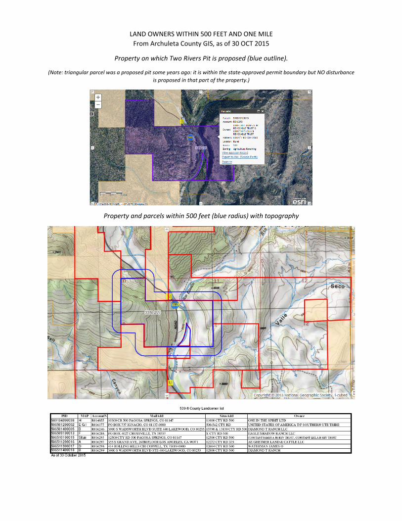
LAND OWNERS WITHIN 500 FEET AND ONE MILE
From Archuleta County GIS, as of 30 OCT 2015
Property on which Two Rivers Pit is proposed (blue outline).
(Note: triangular parcel was a proposed pit some years ago: it is within the state-approved permit boundary but NO disturbance
is proposed in that part of the property.)
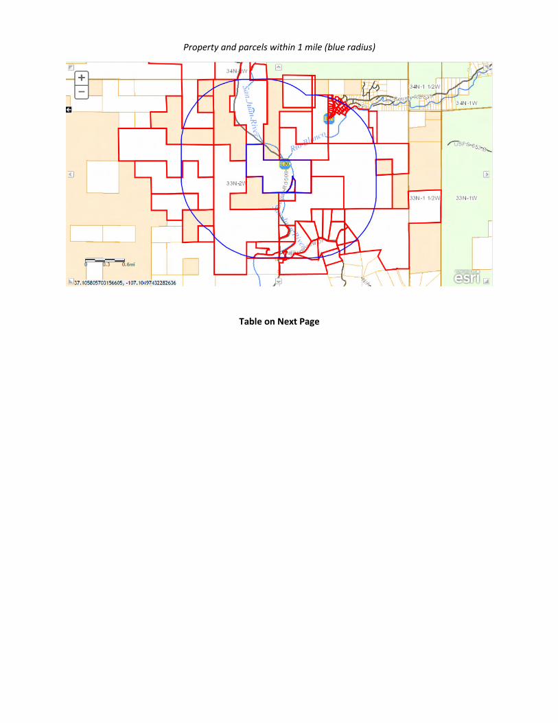
Property and parcels within 500 feet (blue radius) with topography
Property and parcels within 1 mile (blue radius)
Table on Next Page
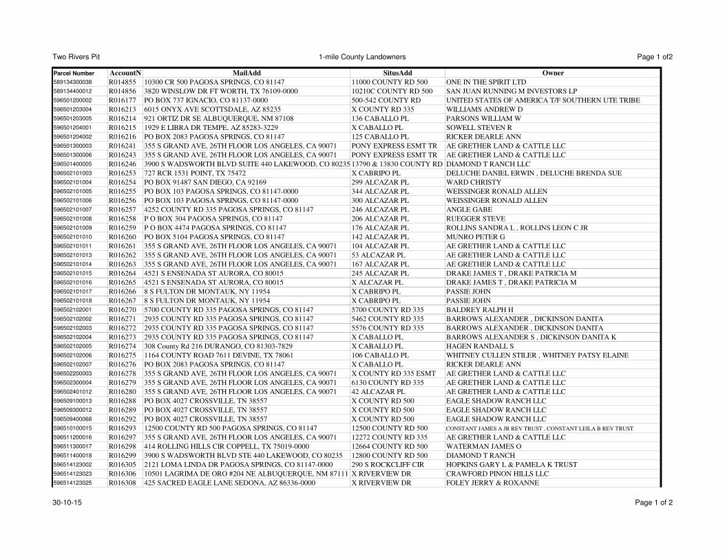
Two Rivers Pit 1-mile County Landowners Page 1 of2
Parcel Number AccountN MailAdd SitusAdd Owner
589134300038 R014855 10300 CR 500 PAGOSA SPRINGS, CO 81147 11000 COUNTY RD 500 ONE IN THE SPIRIT LTD
589134400012 R014856 3820 WINSLOW DR FT WORTH, TX 76109-0000 10210C COUNTY RD 500 SAN JUAN RUNNING M INVESTORS LP
596501200002 R016177 PO BOX 737 IGNACIO, CO 81137-0000 500-542 COUNTY RD UNITED STATES OF AMERICA T/F SOUTHERN UTE TRIBE
596501203004 R016213 6015 ONYX AVE SCOTTSDALE, AZ 85235 X COUNTY RD 335 WILLIAMS ANDREW D
596501203005 R016214 921 ORTIZ DR SE ALBUQUERQUE, NM 87108 136 CABALLO PL PARSONS WILLIAM W
596501204001 R016215 1929 E LIBRA DR TEMPE, AZ 85283-3229 X CABALLO PL SOWELL STEVEN R
596501204002 R016216 PO BOX 2083 PAGOSA SPRINGS, CO 81147 125 CABALLO PL RICKER DEARLE ANN
596501300003 R016241 355 S GRAND AVE, 26TH FLOOR LOS ANGELES, CA 90071 PONY EXPRESS ESMT TR AE GRETHER LAND & CATTLE LLC
596501300006 R016243 355 S GRAND AVE, 26TH FLOOR LOS ANGELES, CA 90071 PONY EXPRESS ESMT TR AE GRETHER LAND & CATTLE LLC
596501400005 R016246 3900 S WADSWORTH BLVD SUITE 440 LAKEWOOD, CO 80235 13790 & 13830 COUNTY RD 500DIAMOND T RANCH LLC
596502101003 R016253 727 RCR 1531 POINT, TX 75472 X CABRIPO PL DELUCHE DANIEL ERWIN , DELUCHE BRENDA SUE
596502101004 R016254 PO BOX 91487 SAN DIEGO, CA 92169 299 ALCAZAR PL WARD CHRISTY
596502101005 R016255 PO BOX 103 PAGOSA SPRINGS, CO 81147-0000 344 ALCAZAR PL WEISSINGER RONALD ALLEN
596502101006 R016256 PO BOX 103 PAGOSA SPRINGS, CO 81147-0000 300 ALCAZAR PL WEISSINGER RONALD ALLEN
596502101007 R016257 4252 COUNTY RD 335 PAGOSA SPRINGS, CO 81147 246 ALCAZAR PL ANGLE GABE
596502101008 R016258 P O BOX 304 PAGOSA SPRINGS, CO 81147 206 ALCAZAR PL RUEGGER STEVE
596502101009 R016259 P O BOX 4474 PAGOSA SPRINGS, CO 81147 176 ALCAZAR PL ROLLINS SANDRA L , ROLLINS LEON C JR
596502101010 R016260 PO BOX 5104 PAGOSA SPRINGS, CO 81147 142 ALCAZAR PL MUNRO PETER G
596502101011 R016261 355 S GRAND AVE, 26TH FLOOR LOS ANGELES, CA 90071 104 ALCAZAR PL AE GRETHER LAND & CATTLE LLC
596502101013 R016262 355 S GRAND AVE, 26TH FLOOR LOS ANGELES, CA 90071 53 ALCAZAR PL AE GRETHER LAND & CATTLE LLC
596502101014 R016263 355 S GRAND AVE, 26TH FLOOR LOS ANGELES, CA 90071 167 ALCAZAR PL AE GRETHER LAND & CATTLE LLC
596502101015 R016264 4521 S ENSENADA ST AURORA, CO 80015 245 ALCAZAR PL DRAKE JAMES T , DRAKE PATRICIA M
596502101016 R016265 4521 S ENSENADA ST AURORA, CO 80015 X ALCAZAR PL DRAKE JAMES T , DRAKE PATRICIA M
596502101017 R016266 8 S FULTON DR MONTAUK, NY 11954 X CABRIPO PL PASSIE JOHN
596502101018 R016267 8 S FULTON DR MONTAUK, NY 11954 X CABRIPO PL PASSIE JOHN
596502102001 R016270 5700 COUNTY RD 335 PAGOSA SPRINGS, CO 81147 5700 COUNTY RD 335 BALDREY RALPH H
596502102002 R016271 2935 COUNTY RD 335 PAGOSA SPRINGS, CO 81147 5462 COUNTY RD 335 BARROWS ALEXANDER , DICKINSON DANITA
596502102003 R016272 2935 COUNTY RD 335 PAGOSA SPRINGS, CO 81147 5576 COUNTY RD 335 BARROWS ALEXANDER , DICKINSON DANITA
596502102004 R016273 2935 COUNTY RD 335 PAGOSA SPRINGS, CO 81147 X CABALLO PL BARROWS ALEXANDER S , DICKINSON DANITA K
596502102005 R016274 308 County Rd 216 DURANGO, CO 81303-7829 X CABALLO PL HAGEN RANDALL S
596502102006 R016275 1164 COUNTY ROAD 7611 DEVINE, TX 78061 106 CABALLO PL WHITNEY CULLEN STILER , WHITNEY PATSY ELAINE
596502102007 R016276 PO BOX 2083 PAGOSA SPRINGS, CO 81147 X CABALLO PL RICKER DEARLE ANN
596502200003 R016278 355 S GRAND AVE, 26TH FLOOR LOS ANGELES, CA 90071 X COUNTY RD 335 ESMT AE GRETHER LAND & CATTLE LLC
596502300004 R016279 355 S GRAND AVE, 26TH FLOOR LOS ANGELES, CA 90071 6130 COUNTY RD 335 AE GRETHER LAND & CATTLE LLC
596502401012 R016280 355 S GRAND AVE, 26TH FLOOR LOS ANGELES, CA 90071 42 ALCAZAR PL AE GRETHER LAND & CATTLE LLC
596509100013 R016288 PO BOX 4027 CROSSVILLE, TN 38557 X COUNTY RD 500 EAGLE SHADOW RANCH LLC
596509300012 R016289 PO BOX 4027 CROSSVILLE, TN 38557 X COUNTY RD 500 EAGLE SHADOW RANCH LLC
596509400068 R016292 PO BOX 4027 CROSSVILLE, TN 38557 X COUNTY RD 500 EAGLE SHADOW RANCH LLC
596510100015 R016293 12500 COUNTY RD 500 PAGOSA SPRINGS, CO 81147 12500 COUNTY RD 500 CONSTANT JAMES A JR REV TRUST , CONSTANT LEILA B REV TRUST
596511200016 R016297 355 S GRAND AVE, 26TH FLOOR LOS ANGELES, CA 90071 12272 COUNTY RD 335 AE GRETHER LAND & CATTLE LLC
596511300017 R016298 414 ROLLING HILLS CIR COPPELL, TX 75019-0000 12664 COUNTY RD 500 WATERMAN JAMES O
596511400018 R016299 3900 S WADSWORTH BLVD STE 440 LAKEWOOD, CO 80235 12800 COUNTY RD 500 DIAMOND T RANCH
596514123002 R016305 2121 LOMA LINDA DR PAGOSA SPRINGS, CO 81147-0000 290 S ROCKCLIFF CIR HOPKINS GARY L & PAMELA K TRUST
596514123023 R016306 10501 LAGRIMA DE ORO #204 NE ALBUQUERQUE, NM 87111 X RIVERVIEW DR CRAWFORD PINON HILLS LLC
596514123025 R016308 425 SACRED EAGLE LANE SEDONA, AZ 86336-0000 X RIVERVIEW DR FOLEY JERRY & ROXANNE
30-10-15 Page 1 of 2
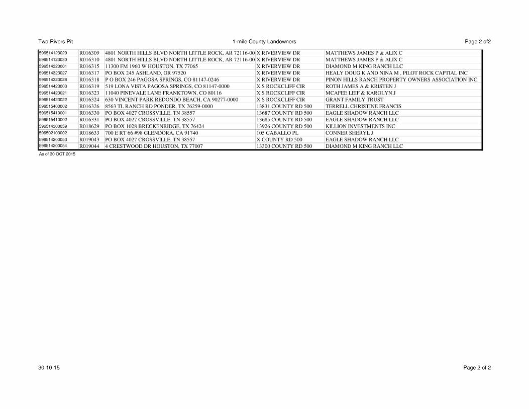
Two Rivers Pit 1-mile County Landowners Page 2 of2
596514123029 R016309 4801 NORTH HILLS BLVD NORTH LITTLE ROCK, AR 72116-0000X RIVERVIEW DR MATTHEWS JAMES P & ALIX C
596514123030 R016310 4801 NORTH HILLS BLVD NORTH LITTLE ROCK, AR 72116-0000X RIVERVIEW DR MATTHEWS JAMES P & ALIX C
596514323001 R016315 11300 FM 1960 W HOUSTON, TX 77065 X RIVERVIEW DR DIAMOND M KING RANCH LLC
596514323027 R016317 PO BOX 245 ASHLAND, OR 97520 X RIVERVIEW DR HEALY DOUG K AND NINA M , PILOT ROCK CAPTIAL INC
596514323028 R016318 P O BOX 246 PAGOSA SPRINGS, CO 81147-0246 X RIVERVIEW DR PINON HILLS RANCH PROPERTY OWNERS ASSOCIATION INC
596514423003 R016319 519 LONA VISTA PAGOSA SPRINGS, CO 81147-0000 X S ROCKCLIFF CIR ROTH JAMES A & KRISTEN J
596514423021 R016323 11040 PINEVALE LANE FRANKTOWN, CO 80116 X S ROCKCLIFF CIR MCAFEE LEIF & KAROLYN J
596514423022 R016324 630 VINCENT PARK REDONDO BEACH, CA 90277-0000 X S ROCKCLIFF CIR GRANT FAMILY TRUST
596515400002 R016326 8563 TL RANCH RD PONDER, TX 76259-0000 13831 COUNTY RD 500 TERRELL CHRISTINE FRANCIS
596515410001 R016330 PO BOX 4027 CROSSVILLE, TN 38557 13687 COUNTY RD 500 EAGLE SHADOW RANCH LLC
596515410002 R016331 PO BOX 4027 CROSSVILLE, TN 38557 13685 COUNTY RD 500 EAGLE SHADOW RANCH LLC
596514300059 R018629 PO BOX 1028 BRECKENRIDGE, TX 76424 13926 COUNTY RD 500 KILLION INVESTMENTS INC
596502103002 R018633 700 E RT 66 #98 GLENDORA, CA 91740 105 CABALLO PL CONNER SHERYL J
596514200053 R019043 PO BOX 4027 CROSSVILLE, TN 38557 X COUNTY RD 500 EAGLE SHADOW RANCH LLC596514200054 R019044 4 CRESTWOOD DR HOUSTON, TX 77007 13300 COUNTY RD 500 DIAMOND M KING RANCH LLC
As of 30 OCT 2015
30-10-15 Page 2 of 2
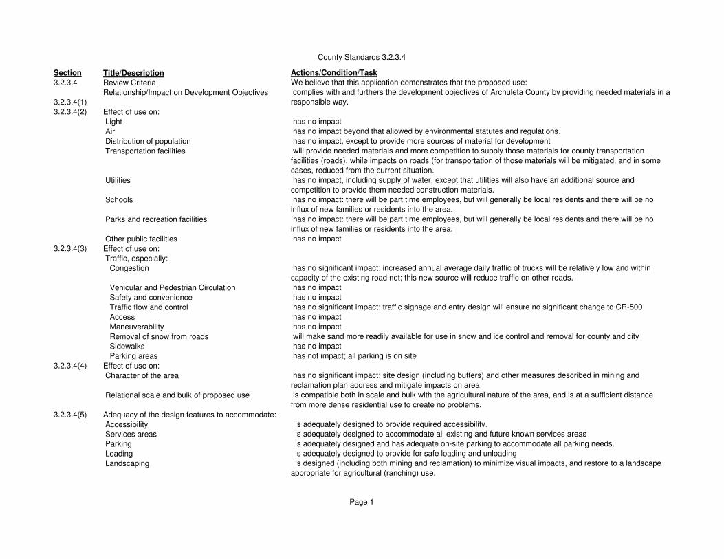
County Standards 3.2.3.4
Section Title/Description Actions/Condition/Task
3.2.3.4 Review Criteria We believe that this application demonstrates that the proposed use:
3.2.3.4(1)
Relationship/Impact on Development Objectives complies with and furthers the development objectives of Archuleta County by providing needed materials in a
responsible way.
3.2.3.4(2) Effect of use on:
Light has no impact
Air has no impact beyond that allowed by environmental statutes and regulations.
Distribution of population has no impact, except to provide more sources of material for development
Transportation facilities will provide needed materials and more competition to supply those materials for county transportation
facilities (roads), while impacts on roads (for transportation of those materials will be mitigated, and in some
cases, reduced from the current situation.
Utilities has no impact, including supply of water, except that utilities will also have an additional source and
competition to provide them needed construction materials.
Schools has no impact: there will be part time employees, but will generally be local residents and there will be no
influx of new families or residents into the area.
Parks and recreation facilities has no impact: there will be part time employees, but will generally be local residents and there will be no
influx of new families or residents into the area.
Other public facilities has no impact
3.2.3.4(3) Effect of use on:
Traffic, especially:
Congestion has no significant impact: increased annual average daily traffic of trucks will be relatively low and within
capacity of the existing road net; this new source will reduce traffic on other roads.
Vehicular and Pedestrian Circulation has no impact
Safety and convenience has no impact
Traffic flow and control has no significant impact: traffic signage and entry design will ensure no significant change to CR-500
Access has no impact
Maneuverability has no impact
Removal of snow from roads will make sand more readily available for use in snow and ice control and removal for county and city
Sidewalks has no impact
Parking areas has not impact; all parking is on site
3.2.3.4(4) Effect of use on:
Character of the area has no significant impact: site design (including buffers) and other measures described in mining and
reclamation plan address and mitigate impacts on area
Relational scale and bulk of proposed use is compatible both in scale and bulk with the agricultural nature of the area, and is at a sufficient distance
from more dense residential use to create no problems.
3.2.3.4(5) Adequacy of the design features to accommodate:
Accessibility is adequately designed to provide required accessibility.
Services areas is adequately designed to accommodate all existing and future known services areas
Parking is adequately designed and has adequate on-site parking to accommodate all parking needs.
Loading is adequately designed to provide for safe loading and unloading
Landscaping is designed (including both mining and reclamation) to minimize visual impacts, and restore to a landscape
appropriate for agricultural (ranching) use.
Page 1

County Standards 3.2.3.4
Buffering is designed to provide 200 feet or more buffer from other properties and significant manmade structures, as
well as significant natural resources.
Lighting is designed to adequately address both needed lighting for safety and security but not contribute to light
pollution.
3.2.3.4(6) Natural resources and wildlife habitat areas:
Natural resources is designed to obtain and use natural resources (sand and gravel) while protecting and conserving other
natural resources and allowing development and use of those, including rangeland and other agricultural use,
oil and gas, and water, to improve use of agricultural natural resources by increasing productivity. (NOTE:
mining of sand and gravel is considered an irrevocable use of that natural resource.)
Wildlife habitat has been determined by state and federal agencies to not impact negatively on wildlife habitat, and will result
in improved wildlife habitat (shared with livestock and other agricultural use) at the end of mining.
3.2.3.4(7)
Other factors: have been addressed in the DRMS application process. The operator/landowner will address other factors as
requested by the Planning Commission and Board of County Commissioners.
Page 2
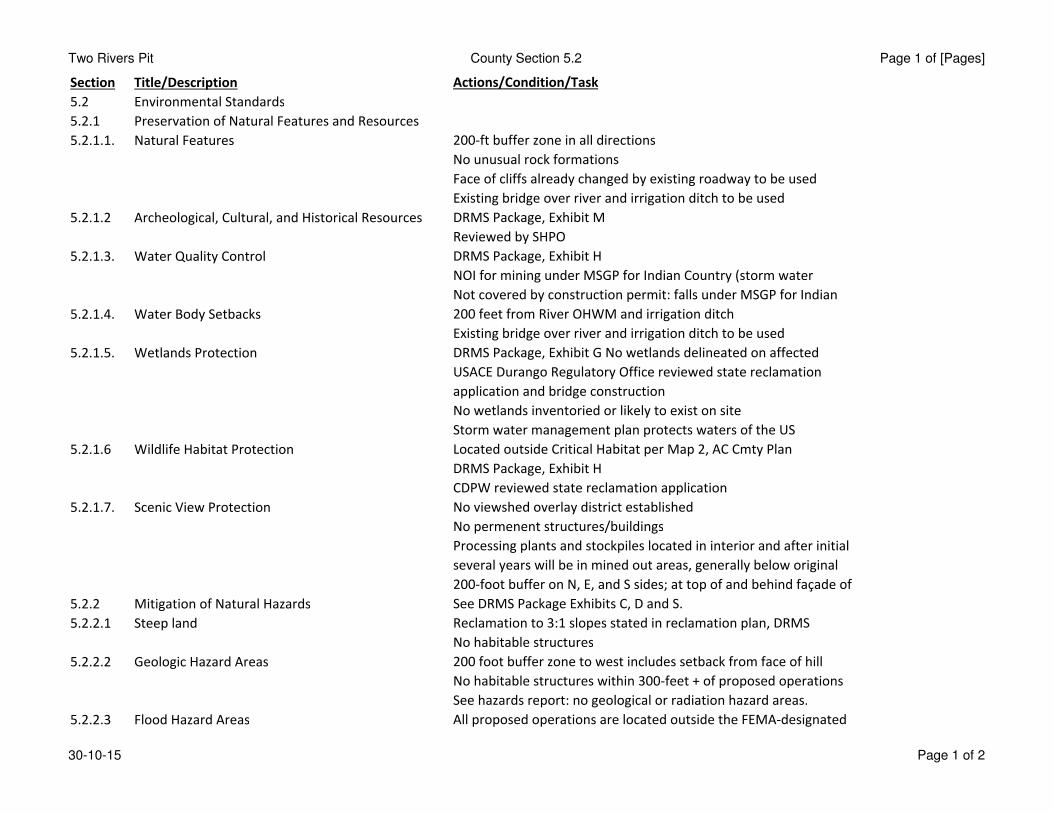
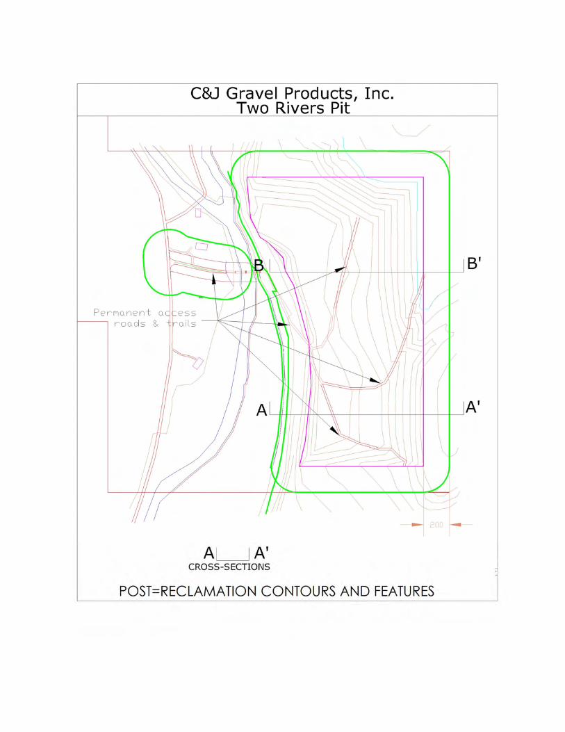
Two Rivers Pit County Section 5.2 Page 1 of [Pages]
Section Title/Description Actions/Condition/Task
5.2 Environmental Standards
5.2.1 Preservation of Natural Features and Resources
5.2.1.1. Natural Features 200-ft buffer zone in all directions
No unusual rock formations
Face of cliffs already changed by existing roadway to be used
Existing bridge over river and irrigation ditch to be used
5.2.1.2 Archeological, Cultural, and Historical Resources DRMS Package, Exhibit M
Reviewed by SHPO
5.2.1.3. Water Quality Control DRMS Package, Exhibit H
NOI for mining under MSGP for Indian Country (storm water
Not covered by construction permit: falls under MSGP for Indian
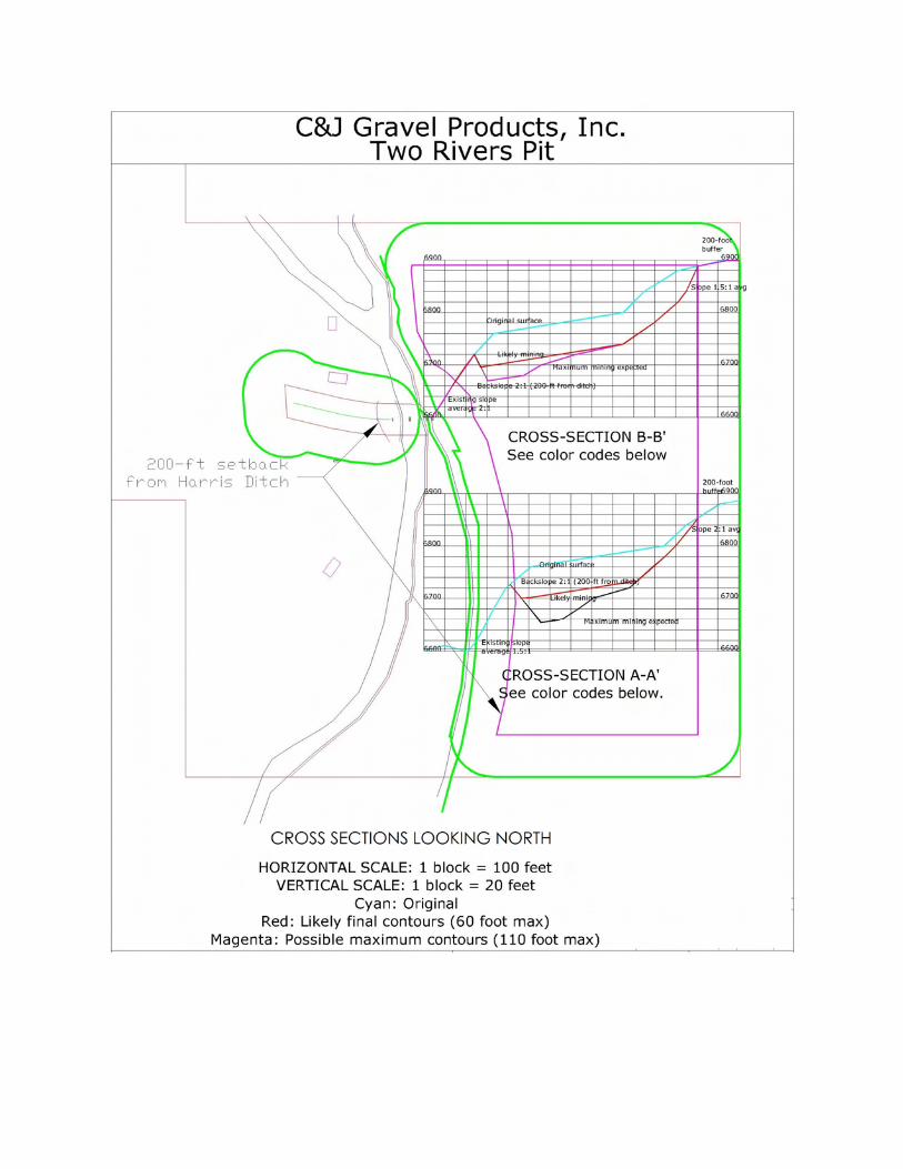
5.2.1.4. Water Body Setbacks 200 feet from River OHWM and irrigation ditch
Existing bridge over river and irrigation ditch to be used
5.2.1.5. Wetlands Protection DRMS Package, Exhibit G No wetlands delineated on affected
USACE Durango Regulatory Office reviewed state reclamation
application and bridge construction
No wetlands inventoried or likely to exist on site
Storm water management plan protects waters of the US
5.2.1.6 Wildlife Habitat Protection Located outside Critical Habitat per Map 2, AC Cmty Plan
DRMS Package, Exhibit H
CDPW reviewed state reclamation application
5.2.1.7. Scenic View Protection No viewshed overlay district established
No permenent structures/buildings
Processing plants and stockpiles located in interior and after initial
several years will be in mined out areas, generally below original
200-foot buffer on N, E, and S sides; at top of and behind façade of
5.2.2 Mitigation of Natural Hazards See DRMS Package Exhibits C, D and S.
5.2.2.1 Steep land Reclamation to 3:1 slopes stated in reclamation plan, DRMS
No habitable structures
5.2.2.2 Geologic Hazard Areas 200 foot buffer zone to west includes setback from face of hill
No habitable structures within 300-feet + of proposed operations
See hazards report: no geological or radiation hazard areas.
5.2.2.3 Flood Hazard Areas All proposed operations are located outside the FEMA-designated
30-10-15 Page 1 of 2
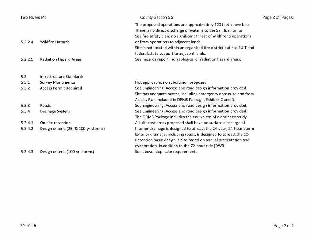
Two Rivers Pit County Section 5.2 Page 2 of [Pages]
The proposed operations are approximately 120 feet above base
There is no direct discharge of water into the San Juan or its
5.2.2.4 Wildfire Hazards
See fire safety plan: no significant threat of wildfire to operations
or from operations to adjacent lands.
Site is not located within an organized fire district but has SUIT and
federal/state support to adjacent lands.
5.2.2.5 Radiation Hazard Areas See hazards report: no geological or radiation hazard areas.
5.3 Infrastructure Standards
5.3.1 Survey Monuments Not applicable: no subdivision proposed
5.3.2 Access Permit Required See Engineering. Access and road design information provided.
Site has adequate access, including emergency access, to and from
Access Plan included in DRMS Package, Exhibits C and D.
5.3.3 Roads See Engineering. Access and road design information provided.
5.3.4 Drainage System See Engineering. Access and road design information provided.
The DRMS Package includes the equivalent of a drainage study
5.3.4.1 On-site retention All affected areas proposed shall have no surface discharge of
5.3.4.2 Design criteria (25- & 100-yr storms) Interior drainage is designed to at least the 24-year, 24-hour storm
Exterior drainage, including roads, is designed to at least the 10-
Retention basin design is also based on annual precipitation and
evaporation, in addition to the 72-hour rule (DWR)
5.3.4.3 Design criteria (100-yr storms) See above: duplicate requirement.
30-10-15 Page 2 of 2
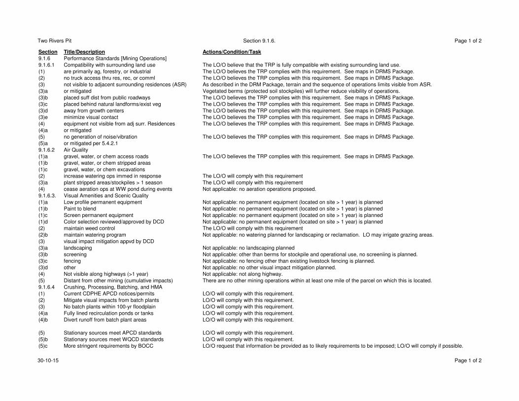
Two Rivers Pit Section 9.1.6. Page 1 of 2
Section Title/Description Actions/Condition/Task
9.1.6 Performance Standards [Mining Operations]
9.1.6.1 Compatibility with surrounding land use The LO/O believe that the TRP is fully compatible with existing surrounding land use.
(1) are primarily ag, forestry, or industrial The LO/O believes the TRP complies with this requirement. See maps in DRMS Package.
(2) no truck access thru res, rec, or comml The LO/O believes the TRP complies with this requirement. See maps in DRMS Package.
(3) not visible to adjacent surrounding residences (ASR) As described in the DRM Package, terrain and the sequence of operations limits visible from ASR.
(3)a or mitigated Vegetated berms (protected soil stockpiles) will further reduce visibility of operations.
(3)b placed suff dist from public roadways The LO/O believes the TRP complies with this requirement. See maps in DRMS Package.
(3)c placed behind natural landforms/exist veg The LO/O believes the TRP complies with this requirement. See maps in DRMS Package.
(3)d away from growth centers The LO/O believes the TRP complies with this requirement. See maps in DRMS Package.
(3)e minimize visual contact The LO/O believes the TRP complies with this requirement. See maps in DRMS Package.
(4) equipment not visible from adj surr. Residences The LO/O believes the TRP complies with this requirement. See maps in DRMS Package.
(4)a or mitigated
(5) no generation of noise/vibration The LO/O believes the TRP complies with this requirement. See maps in DRMS Package.
(5)a or mitigated per 5.4.2.1
9.1.6.2 Air Quality
(1)a gravel, water, or chem access roads The LO/O believes the TRP complies with this requirement. See maps in DRMS Package.
(1)b gravel, water, or chem stripped areas
(1)c gravel, water, or chem excavations
(2) increase watering ops immed in response The LO/O will comply with this requirement
(3)a plant stripped areas/stockpiles > 1 season The LO/O will comply with this requirement
(4) cease aeration ops at WW pond during events Not applicable: no aeration operations proposed.
9.1.6.3. Visual Amenities and Scenic Quality
(1)a Low profile permanent equipment Not applicable: no permanent equipment (located on site > 1 year) is planned
(1)b Paint to blend Not applicable: no permanent equipment (located on site > 1 year) is planned
(1)c Screen permanent equipment Not applicable: no permanent equipment (located on site > 1 year) is planned
(1)d Color selection reviewed/approved by DCD Not applicable: no permanent equipment (located on site > 1 year) is planned
(2) maintain weed control The LO/O will comply with this requirement
(2)b maintain watering program Not applicable: no watering planned for landscaping or reclamation. LO may irrigate grazing areas.
(3) visual impact mitigation appvd by DCD
(3)a landscaping Not applicable: no landscaping planned
(3)b screening Not applicable: other than berms for stockpile and operational use, no screeniing is planned.
(3)c fencing Not applicable: no fencing other than existing livestock fencing is planned.
(3)d other Not applicable: no other visual impact mitigation planned.
(4) Not visible along highways (>1 year) Not applicable: not along highway.
(5) Distant from other mining (cumulative impacts) There are no other mining operations within at least one mile of the parcel on which this is located.
9.1.6.4 Crushing, Processing, Batching, and HMA
(1) Current CDPHE APCD notices/permits LO/O will comply with this requirement.
(2) Mitigate visual impacts from batch plants LO/O will comply with this requirement.
(3) No batch plants within 100-yr floodplain LO/O will comply with this requirement.
(4)a Fully lined recirculation ponds or tanks LO/O will comply with this requirement.
(4)b Divert runoff from batch plant areas LO/O will comply with this requirement.
(5) Stationary sources meet APCD standards LO/O will comply with this requirement.
(5)b Stationary sources meet WQCD standards LO/O will comply with this requirement.
(5)c More stringent requirements by BOCC LO/O request that information be provided as to likely requirements to be imposed; LO/O will comply if possible.
30-10-15 Page 1 of 2
Two Rivers Pit Section 9.1.6. Page 2 of 2
(6)a Submit relocation inspection of batch plant to CPD To our knowledge, there are no inspections by CDPHE Divisions upon relocation of equipment.
(6)b Submit annual inspection of batch plant to CPD To our knowledge, there are no annual inspections by CDPHE of equipment. If CDPHE inspects,
O will submit copy of report when (if) received.
(7)a County permit limited to 20 years Although anticipated estimated operations in DRMS package is greater than 20 year, LO/O understand this limit.
(7)b New permit review required for renewal LO/O understand that a new permit review is required and that the BOCC may add conditions
(8)a County performance guarantee LO/O request that a copy of the required guarantee be provided for review and to ensure we can comply
(8)b Provide BOCC certified copy of DRMS bond (warranties) LO/O will comply with this requirement.
LO/O Landowner/Operator
O Operator
LO Landowner
30-10-15 Page 2 of 2
Two Rivers Pit County Standards 9.1.7 Page 1 of 2
Section Title/Description Actions/Condition/Task
9.1.7 Submittals
9.1.7.1 Copy of Application submitted to CDMG Note: CDMG is now the Colorado Division of Reclamation, Mining, and Safety (DRMS)
(1) Site Plan Exhibits B (Sheets B1-B3) and C (Sheets C1-C3) are the “site plan”
(2) Operations Plan Exhibit C (Mining Plan) appears to be the closest to this request, but portions of other exhibits may also be included.
(3) Road Use Plan There is no “road use plan” or similar in the DRMS Package. Sheets C4-C5 show the access road.
(4) Reclamation Plan Exhibits E (Reclamation Plan) and F (Reclamation Plan Maps and Cross-Sections)
(5) Copy of Bond The Performance Warranty and Financial Warranty are not prepared or issued until the
Reclamation Permit Application is approved and posted: after county process is completed.
(6)a Wildlife DRMS Package Exhibit H
(6)b Soils DRMS Package Exhibit I
(6)c Geology DRMS Package Exhibit I, and Sheet B-3
(6)d Hydrology DRMS Package Exhibit G
(6)e Other environmental information DRMS Package, Exhibits C, D, E, F, G, I, J, L, M, and S
9.1.7.2. Maps and Plans
(1)a Maps: Location DRMS Package, Exhibit B
(1)b Maps: Mining DRMS Package, Exhibit C
(1)c Maps: Reclamation DRMS Package, Exhibit F
(1)d Maps: Adjacent owners DRMS Package, Exhibit(s)
(1)e Maps: Water DRMS Package, Exhibit G
(1)f Maps: Soil DRMS Package, Exhibit(s)
(1)g Maps: Geology DRMS Package, Exhibit B Sheet B-3, and Exhibit
(1)h Maps: Structures DRMS Package, Exhibit S
(2) USGS Quad 1-mile radius Exhibit B of DRMS Package
(3) Site Plan … exploration operation Not applicable: no exploration planned. Mining and Reclamation Site Plans are in DRMS Package Exhibits C and F
(4) Grading Plan Maps in Exhibits C and F of DRMS Package
(5) Contour Map Maps in Exhibits C and F of DRMS Package
(6) Site Description: Exhibit D of DRMS Package has a written description of the site, and references other Exhibits
(6)a Existing vegetative types DRMS Package Exhibit J.
(6)b Existing land use of site, surrounding DRMS Package, Exhibit M, Map M-1, and Exhibit O
(6)c Location of various items Extraction areas: stockpiles, topsoil stockpiles: overburden stockpiles: None, Nearest waterways
Nearest residences: Proposed/existing fencing: All shown in various maps in DRMS Package
(7) Written description of access roads: ATT # 9 (Engineering) Sections a and b.
(7)a Route recon details ATT # 9 (Engineering) Sections a and b.
(7)b Anticipated impacts and traffic ATT # 9 (Engineering) Sections a and b.
(7)c Areas along route ATT # 9 (Engineering) Sections a and b.
(7)d Location of internal haul roads DRMS Package, Sheet F3
(8) Project description DRMS Package, Exhibit D (Mining) and Exhibit E (Reclamation)
(8)a Size/timing of extraction DRMS Package, Exhibit D (Mining) and Exhibit E (Reclamation)
(8)b Depth of topsoil/overburden DRMS Package, Exhibit D (Mining) and Exhibit E (Reclamation)
(8)c Max area to be disturbed at any one time DRMS Package, Exhibit D (Mining) and Exhibit E (Reclamation)
(8)d Methods, times of extraction, employees DRMS Package, Exhibit D (Mining) and Exhibit E (Reclamation), normally 2-3 employees on-site.
(8)e Expected volume/annual volume DRMS Package, Exhibits C and M (fr discussion of haul and traffic)
(8)f Outdoor storage and weed control plan DRMS Package Exhibit J. All outdoor storage shall be on the plant site and within the working floor of the pit.
See also item (10)e below (ATT # 9 (Engineering) Section D
30-10-15 Page 1 of 2
Two Rivers Pit County Standards 9.1.7 Page 2 of 2
(9) Blasting plan and information DRMS Package, Exhibit M: No blasting is proposed for the Two Rivers Pit
(10) Reclamation Plan DRMS Package, Exhibits E and F
(10)a Proposed final land use DRMS Package, Exhibit E (Reclamation)
(10)b Timing of reclamation DRMS Package, Exhibits E and F
(10)c Salvage, redistribution and disposal DRMS Package, Exhibit D (Mining) and Exhibit E (Reclamation)
(10)d SCS/MLRB seeding/revegetation DRMS Package, Exhibit J. ATT #
(10)e Weed control plan DRMS Policy Letter and DRMS Package Exhibit J, ATT # 9 (Engineering) Section D
(11) Environmental/vicinity impact DRMS Package, Exhibits C, D, E, F, G, I, J, L, M, and S
(11)a Soils DRMS Package, Exhibit I
(11)b Visual impacts: area/neighborhood, roads DRMS Package, Exhibit M
(11)c Wildlife DRMS Package, Exhibit H
(11)d Geologic, floodplain, hydo, wildfire hazards DRMS Package: Geology: Exhibits B & I Floodplain: Exhibit G Sheet G-X Hydrological: Exhibit G, Wildfire:
(11)e Potential pollution incl noise, water rights DRMS Package, Exhibit M
(11)f Climatological data DRMS Package, Exhibit K
(11)g Surrounding property uses, land values DRMS Package, Exhibit M, Map M-1, and Exhibit O
(12) Impact mitigation plan DRMS Package, Exhibits C, D, E, F, G, I, J, L, M, and S
(12)a Visual DRMS Package, Exhibit M and ATT # 17
(12)b Wildlife DRMS Package, Exhibit H
(12)c Geologic, floodplain, hydo, wildfire hazards DRMS Package: Geology: Exhibits B & I Floodplain: Exhibit G Sheet G-X Hydrological: Exhibit G, Wildfire:
(12)d Air pollution DRMS Package, Exhibit M
(12)e Water quality and quantity/augmentation DRMS Package, Exhibit G
(12)f Significant vegetation preservation DRMS Package, Exhibit J
(13) Fugitive Dust Control Plan DRMS Package, Exhibit M and ATT # 9 (Engineering) Section e.
DRMS Package is Attachment 16 and includes approval letter after MLRB decision.
30-10-15 Page 2 of 2
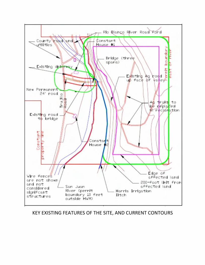
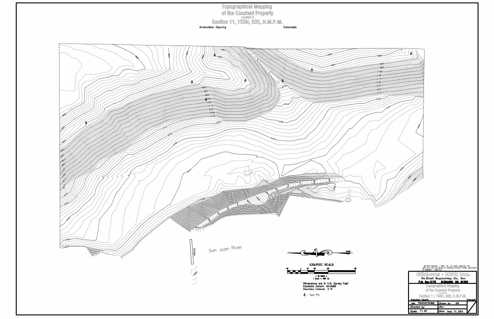
KEY EXISTING FEATURES OF THE SITE, AND CURRENT CONTOURS
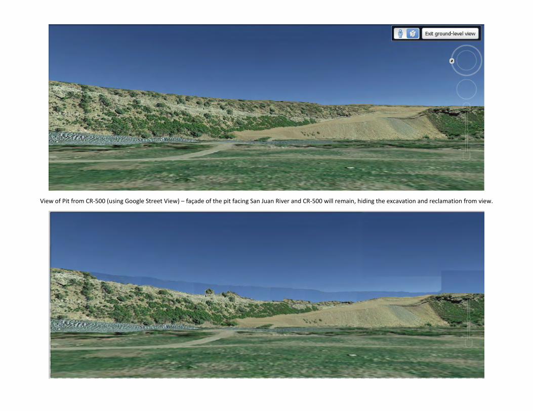
View of Pit from CR-500 (using Google Street View) – façade of the pit facing San Juan River and CR-500 will remain, hiding the excavation and reclamation from view.
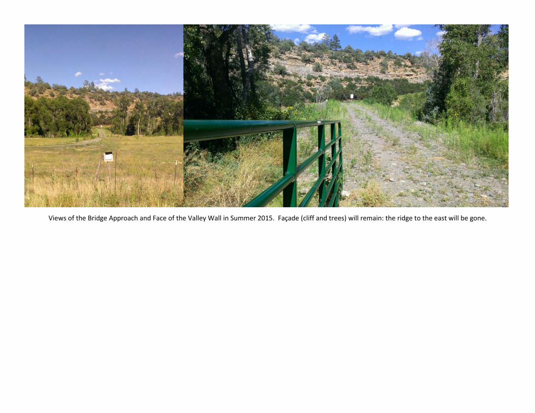
Views of the Bridge Approach and Face of the Valley Wall in Summer 2015. Façade (cliff and trees) will remain: the ridge to the east will be gone.