Embed Size (px)
Citation preview
Student: ………………………… Date received: ………………
Handout 11 of 14
(Topic 4.0)
Geological Hazards
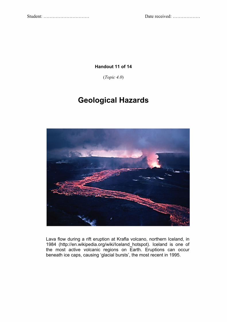
Lava flow during a rift eruption at Krafla volcano, northern Iceland, in 1984 (http://en.wikipedia.org/wiki/Iceland_hotspot). Iceland is one of the most active volcanic regions on Earth. Eruptions can occur beneath ice caps, causing ‘glacial bursts’, the most recent in 1995.
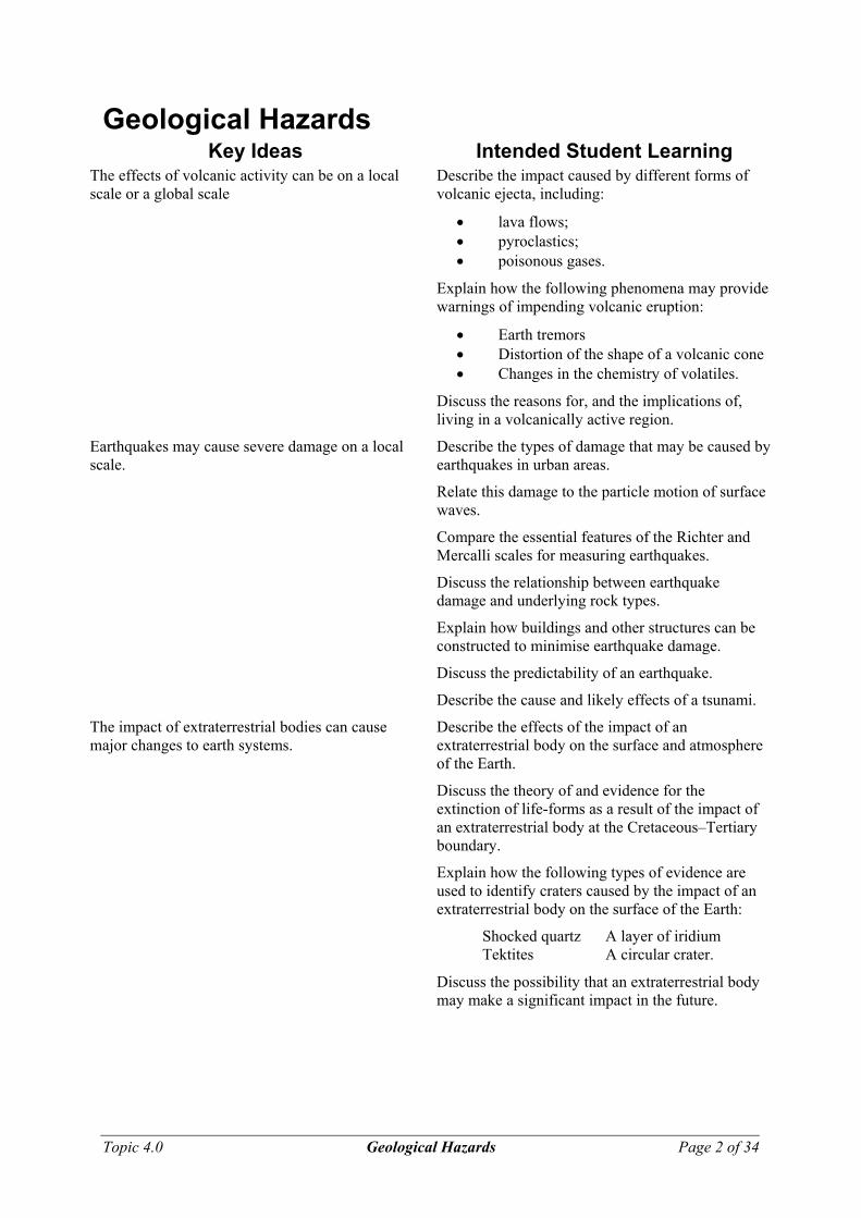
Geological Hazards Key Ideas Intended Student Learning
The effects of volcanic activity can be on a local scale or a global scale
Describe the impact caused by different forms of volcanic ejecta, including:
• lava flows; • pyroclastics; • poisonous gases.
Explain how the following phenomena may provide warnings of impending volcanic eruption:
• Earth tremors • Distortion of the shape of a volcanic cone • Changes in the chemistry of volatiles.
Discuss the reasons for, and the implications of, living in a volcanically active region.
Earthquakes may cause severe damage on a local scale.
Describe the types of damage that may be caused by earthquakes in urban areas.
Relate this damage to the particle motion of surface waves.
Compare the essential features of the Richter and Mercalli scales for measuring earthquakes.
Discuss the relationship between earthquake damage and underlying rock types.
Explain how buildings and other structures can be constructed to minimise earthquake damage.
Discuss the predictability of an earthquake.
Describe the cause and likely effects of a tsunami.
The impact of extraterrestrial bodies can cause major changes to earth systems.
Describe the effects of the impact of an extraterrestrial body on the surface and atmosphere of the Earth.
Discuss the theory of and evidence for the extinction of life-forms as a result of the impact of an extraterrestrial body at the Cretaceous–Tertiary boundary.
Explain how the following types of evidence are used to identify craters caused by the impact of an extraterrestrial body on the surface of the Earth:
Shocked quartz A layer of iridium Tektites A circular crater.
Discuss the possibility that an extraterrestrial body may make a significant impact in the future.
Topic 4.0 Geological Hazards Page 2 of 34
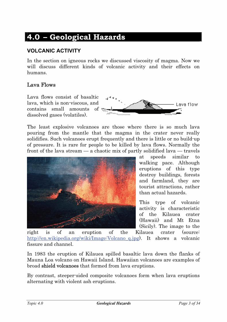
4.0 – Geological Hazards VOLCANIC ACTIVITY
In the section on igneous rocks we discussed viscosity of magma. Now we will discuss different kinds of volcanic activity and their effects on humans. Lava Flows Lava flows consist of basaltic lava, which is non-viscous, and contains small amounts of dissolved gases (volatiles). The least explosive volcanoes are those where there is so much lava pouring from the mantle that the magma in the crater never really solidifies. Such volcanoes erupt frequently and there is little or no build-up of pressure. It is rare for people to be killed by lava flows. Normally the front of the lava stream — a chaotic mix of partly solidified lava — travels
at speeds similar to walking pace. Although eruptions of this type destroy buildings, forests and farmland, they are tourist attractions, rather than actual hazards.
Topic 4.0 Geological Hazards Page 3 of 34
This type of volcanic activity is characteristic of the Kilauea crater (Hawaii) and Mt Etna (Sicily). The image to the
right is of an eruption of the Kilauea crater (source: http://en.wikipedia.org/wiki/Image:Volcano_q.jpg). It shows a volcanic fissure and channel.
In 1983 the eruption of Kilauea spilled basaltic lava down the flanks of Mauna Loa volcano on Hawaii Island. Hawaiian volcanoes are examples of broad shield volcanoes that formed from lava eruptions.
By contrast, steeper-sided composite volcanoes form when lava eruptions alternating with violent ash eruptions.
Pyroclastics
Lava itself may not be a significant threat to human life, but many volcanoes possess other (more dangerous) features that are caused by volatiles (gases) dissolved within the magma.
Andesitic magma, more viscous than basaltic magma, contains a much higher proportion of volatiles.
As this magma rises and the load pressure acting on it decreases, the volatiles expand rapidly, causing explosive activity. Gases may cause fountains of molten rock, which become tiny droplets and harden into fine ash. Particles of ash and dust can be carried many kilometres into the atmosphere forming a characteristic cloud. A sudden expansion of gas may blow the top off a mountain.
The mixture of ash and dust is known as pyroclastic material.
Alternatively, gas and magma may pour out of a volcano in the form of a froth that, instead of rising into the air, pours down the side of the volcano to form a red-hot glowing avalanche, or nuée ardenté.
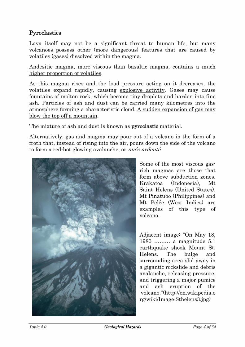
Some of the most viscous gas-rich magmas are those that form above subduction zones. Krakatoa (Indonesia), Mt Saint Helens (United States), Mt Pinatubo (Philippines) and Mt Pelée (West Indies) are examples of this type of volcano. Adjacent image: “On May 18, 1980 ……… a magnitude 5.1 earthquake shook Mount St. Helens. The bulge and surrounding area slid away in a gigantic rockslide and debris avalanche, releasing pressure, and triggering a major pumice and ash eruption of the volcano.”(http://en.wikipedia.org/wiki/Image:Sthelens3.jpg)
Topic 4.0 Geological Hazards Page 4 of 34
As well as burying a wide area around the volcano in ash, pyroclastic materials affect the atmosphere. They can damage aircraft engines and cause climate changes.
Topic 4.0 Geological Hazards Page 5 of 34
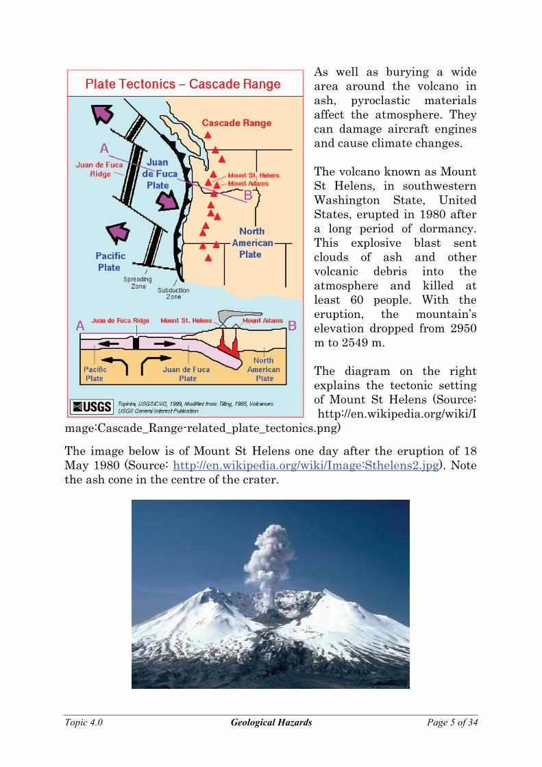
The volcano known as Mount St Helens, in southwestern Washington State, United States, erupted in 1980 after a long period of dormancy. This explosive blast sent clouds of ash and other volcanic debris into the atmosphere and killed at least 60 people. With the eruption, the mountain’s elevation dropped from 2950 m to 2549 m. The diagram on the right explains the tectonic setting of Mount St Helens (Source: http://en.wikipedia.org/wiki/I
mage:Cascade_Range-related_plate_tectonics.png)
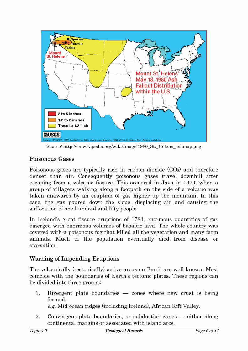
The image below is of Mount St Helens one day after the eruption of 18 May 1980 (Source: http://en.wikipedia.org/wiki/Image:Sthelens2.jpg). Note the ash cone in the centre of the crater.
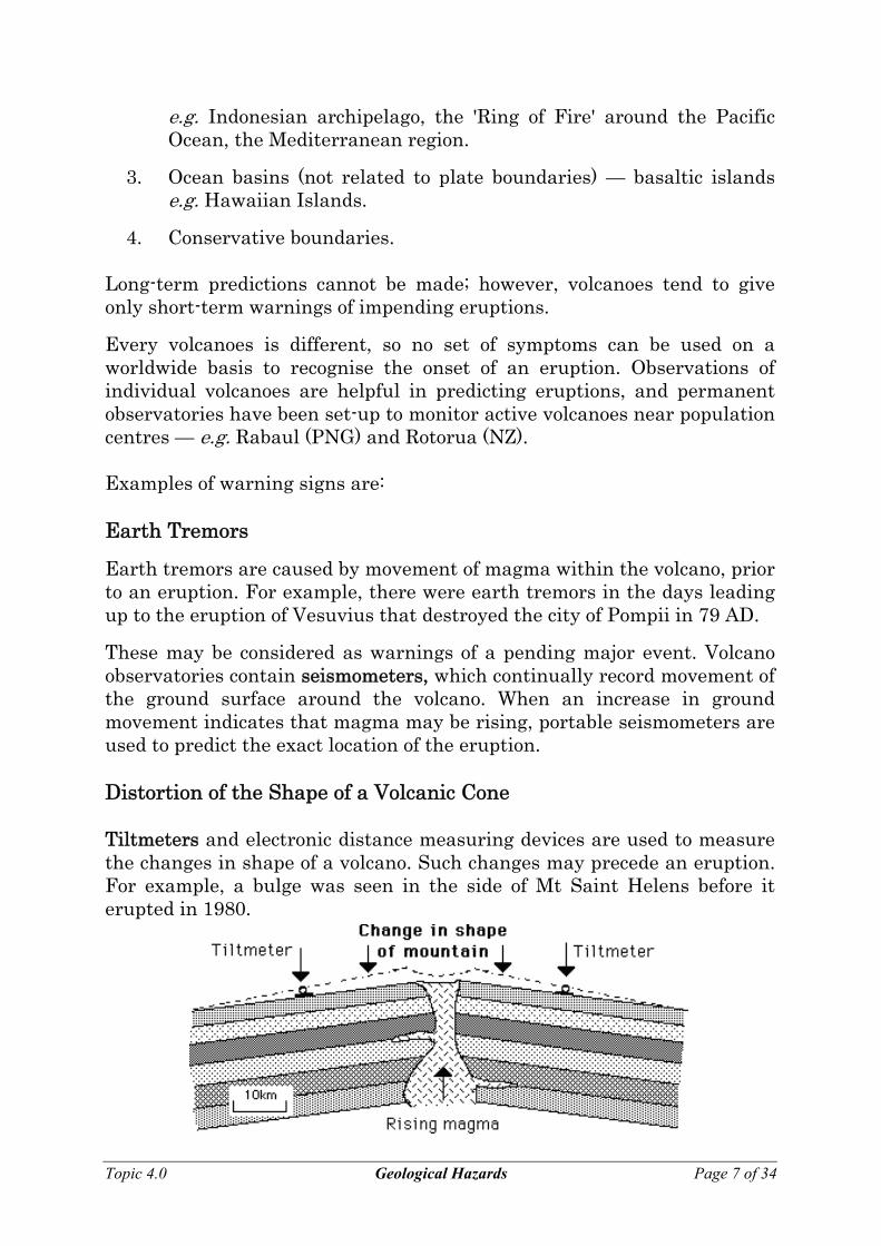
Source: http://en.wikipedia.org/wiki/Image:1980_St._Helens_ashmap.png
Poisonous Gases
Poisonous gases are typically rich in carbon dioxide (CO2) and therefore denser than air. Consequently poisonous gases travel downhill after escaping from a volcanic fissure. This occurred in Java in 1979, when a group of villagers walking along a footpath on the side of a volcano was taken unawares by an eruption of gas higher up the mountain. In this case, the gas poured down the slope, displacing air and causing the suffocation of one hundred and fifty people.
In Iceland’s great fissure eruptions of 1783, enormous quantities of gas emerged with enormous volumes of basaltic lava. The whole country was covered with a poisonous fog that killed all the vegetation and many farm animals. Much of the population eventually died from disease or starvation. Warning of Impending Eruptions
The volcanically (tectonically) active areas on Earth are well known. Most coincide with the boundaries of Earth's tectonic plates. These regions can be divided into three groups:
1. Divergent plate boundaries — zones where new crust is being formed.
e.g. Mid-ocean ridges (including Iceland), African Rift Valley.
2. Convergent plate boundaries, or subduction zones — either along continental margins or associated with island arcs.
Topic 4.0 Geological Hazards Page 6 of 34
e.g. Indonesian archipelago, the 'Ring of Fire' around the Pacific Ocean, the Mediterranean region.
3. Ocean basins (not related to plate boundaries) — basaltic islands e.g. Hawaiian Islands.
4. Conservative boundaries. Long-term predictions cannot be made; however, volcanoes tend to give only short-term warnings of impending eruptions.
Every volcanoes is different, so no set of symptoms can be used on a worldwide basis to recognise the onset of an eruption. Observations of individual volcanoes are helpful in predicting eruptions, and permanent observatories have been set-up to monitor active volcanoes near population centres — e.g. Rabaul (PNG) and Rotorua (NZ). Examples of warning signs are: Earth Tremors
Earth tremors are caused by movement of magma within the volcano, prior to an eruption. For example, there were earth tremors in the days leading up to the eruption of Vesuvius that destroyed the city of Pompii in 79 AD.
These may be considered as warnings of a pending major event. Volcano observatories contain seismometers, which continually record movement of the ground surface around the volcano. When an increase in ground movement indicates that magma may be rising, portable seismometers are used to predict the exact location of the eruption. Distortion of the Shape of a Volcanic Cone Tiltmeters and electronic distance measuring devices are used to measure the changes in shape of a volcano. Such changes may precede an eruption. For example, a bulge was seen in the side of Mt Saint Helens before it erupted in 1980. Topic 4.0 Geological Hazards Page 7 of 34
Changes in the Chemistry of Volatiles
The composition and temperature of gases emitted from volcanoes between eruptions is also monitored. An increase in the amount of sulphur dioxide (SO2) in the volatiles often indicates that an eruption is impending.
The only successful defensive measure is evacuation of the area. Unfortunately an eruption does not always follow the predictions described above. Whole communities have been evacuated, causing major disruptions to peoples lives; however, the volcano has not erupted! Living in a Volcanically Active Region
Advantages:
Only three in every hundred eruptions are likely to cause significant danger to people living and working around a volcano. Eruptions are relatively uncommon, and there are many benefits of living in volcanic areas.
Volcanoes are places where new rock is created from the magma or pyroclastic materials, which have risen from the mantle. This volcanic rock contains unaltered minerals, which react with air and water and (rapidly) chemically weather to provide essential nutrients for plants. Even a thin fall of ash can result in improved soil nutrition and higher growth for food crops.
Scarce mineral elements, such as copper, chrome, lead and gold, are present in magma. When concentrated, over thousands of years, by hydrothermal processes, these elements may form ore bodies. Other minerals, like sulphur or mercury, can be deposited directly from volatiles.
The rocks in volcanic regions are typically very hot, and in regions where there is a good supply of groundwater, enough steam can be produced to drive electrical turbines. Electricity is produced by geothermal energy in New Zealand and other volcanic areas of the world.
As well and being tourist attractions in their own right, volcanoes are often in scenically beautiful regions. Consequently, many tourist facilities are built near them (e.g. Mount St Helens). Implications
Volcanoes that have the potential to affect human life and infrastructure must be continuously monitored. There must also be plans for evacuating the area if warning signs are detected. Prediction of volcanic eruptions is not an exact science!
Topic 4.0 Geological Hazards Page 8 of 34
EARTHQUAKES
Causes of Earthquakes Earthquakes occur in areas where rocks are subject to stresses and deforming forces. Rock is slightly elastic, and can bend until the applied force is greater than the strength of the rocks.
If the stress is too great, the rock then breaks, or 'snaps' into a new position. This process causes vibrations to be generated at the fracture. These vibrations travel through rocks as earthquakes.
Earthquakes at Plate Boundaries
The vast majority of large earthquakes occur at plate boundaries, and each type of plate boundary is characterised by a particular type of earthquake activity.
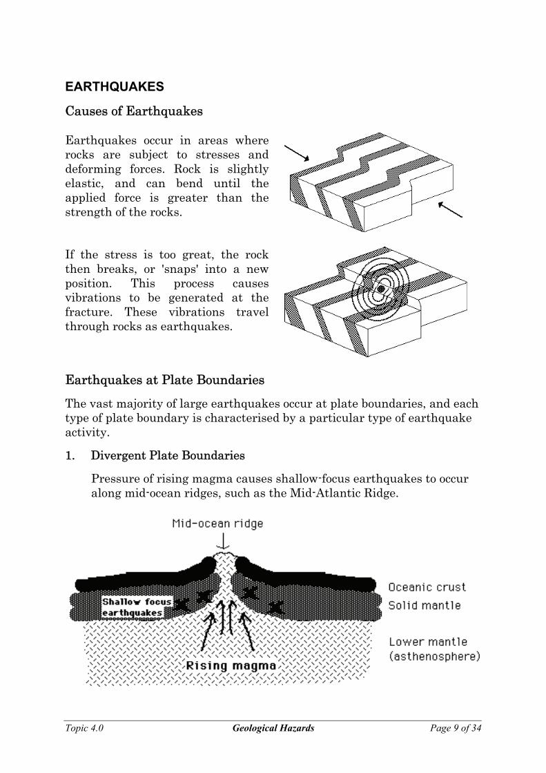
1. Divergent Plate Boundaries
Pressure of rising magma causes shallow-focus earthquakes to occur along mid-ocean ridges, such as the Mid-Atlantic Ridge.
Topic 4.0 Geological Hazards Page 9 of 34
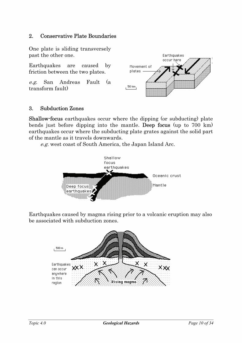
2. Conservative Plate Boundaries One plate is sliding transversely past the other one.
Earthquakes are caused by friction between the two plates.
e.g. San Andreas Fault (a transform fault)
3. Subduction Zones
Shallow-focus earthquakes occur where the dipping (or subducting) plate bends just before dipping into the mantle. Deep focus (up to 700 km) earthquakes occur where the subducting plate grates against the solid part of the mantle as it travels downwards. e.g. west coast of South America, the Japan Island Arc. Earthquakes caused by magma rising prior to a volcanic eruption may also be associated with subduction zones.
Topic 4.0 Geological Hazards Page 10 of 34
Intra-Plate Earthquakes
Topic 4.0 Geological Hazards Page 11 of 34
A significant number of earthquakes, such as those that occur in South Australia, are not close to any plate boundaries. They may be associated with plate boundaries that once existed in those regions, or weaknesses caused by collision or separation of continents.
Minor earthquakes occur in the Mount Lofty and Flinders Ranges because the fault blocks that make up the ranges are constantly moving up and down.
This movement started at 45 Ma, when Australia began to separate from Antarctica. Damage Caused by Earthquakes
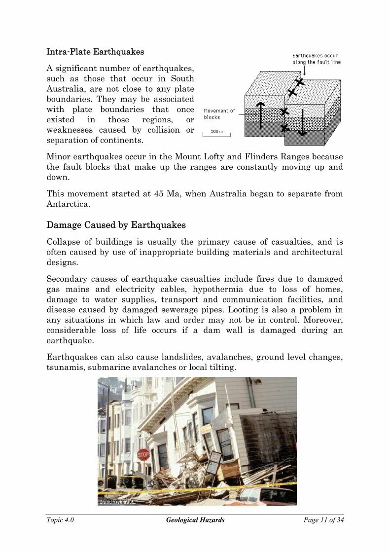
Collapse of buildings is usually the primary cause of casualties, and is often caused by use of inappropriate building materials and architectural designs.
Secondary causes of earthquake casualties include fires due to damaged gas mains and electricity cables, hypothermia due to loss of homes, damage to water supplies, transport and communication facilities, and disease caused by damaged sewerage pipes. Looting is also a problem in any situations in which law and order may not be in control. Moreover, considerable loss of life occurs if a dam wall is damaged during an earthquake.
Earthquakes can also cause landslides, avalanches, ground level changes, tsunamis, submarine avalanches or local tilting.
Above image: The 1989 Loma Prieta earthquake measured 7.1 on the Richter scale. Centred just south of San Francisco, the quake shook the entire San Francisco Bay area, causing extensive damage to older buildings in the Marina District (see below). The quake also caused the collapse of a highway in Oakland and part of the San Francisco-Oakland Bay Bridge. Surface Waves
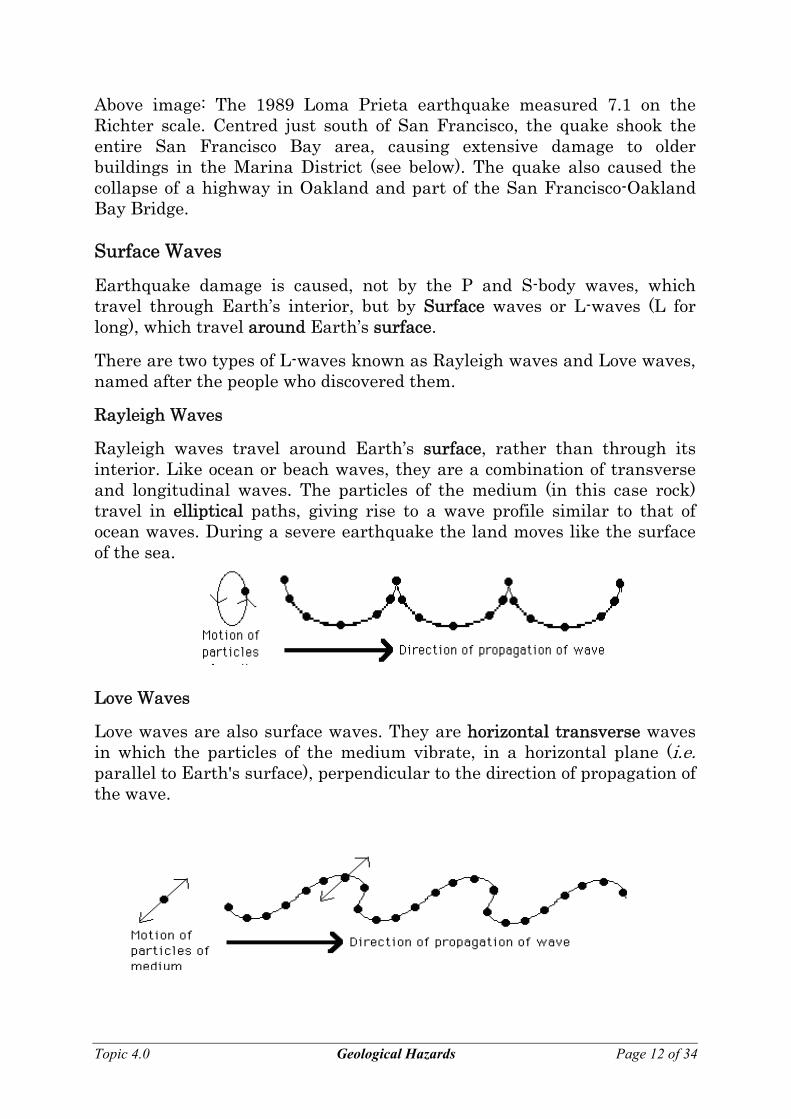
Earthquake damage is caused, not by the P and S-body waves, which travel through Earth’s interior, but by Surface waves or L-waves (L for long), which travel around Earth’s surface.
There are two types of L-waves known as Rayleigh waves and Love waves, named after the people who discovered them.
Rayleigh Waves
Rayleigh waves travel around Earth’s surface, rather than through its interior. Like ocean or beach waves, they are a combination of transverse and longitudinal waves. The particles of the medium (in this case rock) travel in elliptical paths, giving rise to a wave profile similar to that of ocean waves. During a severe earthquake the land moves like the surface of the sea. Love Waves
Love waves are also surface waves. They are horizontal transverse waves in which the particles of the medium vibrate, in a horizontal plane (i.e. parallel to Earth's surface), perpendicular to the direction of propagation of the wave.
Topic 4.0 Geological Hazards Page 12 of 34
Measuring Earthquakes
The Mercalli scale
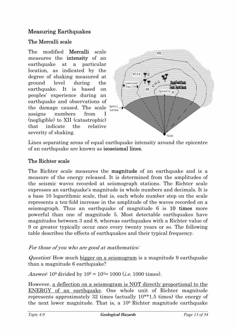
The modified Mercalli scale measures the intensity of an earthquake at a particular location, as indicated by the degree of shaking measured at ground level during the earthquake. It is based on peoples’ experience during an earthquake and observations of the damage caused. The scale assigns numbers from I (negligible) to XII (catastrophic) that indicate the relative severity of shaking.
Lines separating areas of equal earthquake intensity around the epicentre of an earthquake are known as isoseismal lines. The Richter scale
The Richter scale measures the magnitude of an earthquake and is a measure of the energy released. It is determined from the amplitudes of the seismic waves recorded at seismograph stations. The Richter scale expresses an earthquake's magnitude in whole numbers and decimals. It is a base 10 logarithmic scale, that is, each whole number step on the scale represents a ten-fold increase in the amplitude of the waves recorded on a seismograph. Thus an earthquake of magnitude 6 is 10 times more powerful than one of magnitude 5. Most detectable earthquakes have magnitudes between 3 and 8, whereas earthquakes with a Richter value of 9 or greater typically occur once every twenty years or so. The following table describes the effects of earthquakes and their typical frequency. For those of you who are good at mathematics:
Question: How much bigger on a seismogram is a magnitude 9 earthquake than a magnitude 6 earthquake?
Answer: 109 divided by 106 = 103= 1000 (i.e. 1000 times).
However, a deflection on a seismogram is NOT directly proportional to the ENERGY of an earthquake. One whole unit of Richter magnitude represents approximately 32 times (actually 10**1.5 times) the energy of the next lower magnitude. That is, a 109 Richter magnitude earthquake
Topic 4.0 Geological Hazards Page 13 of 34
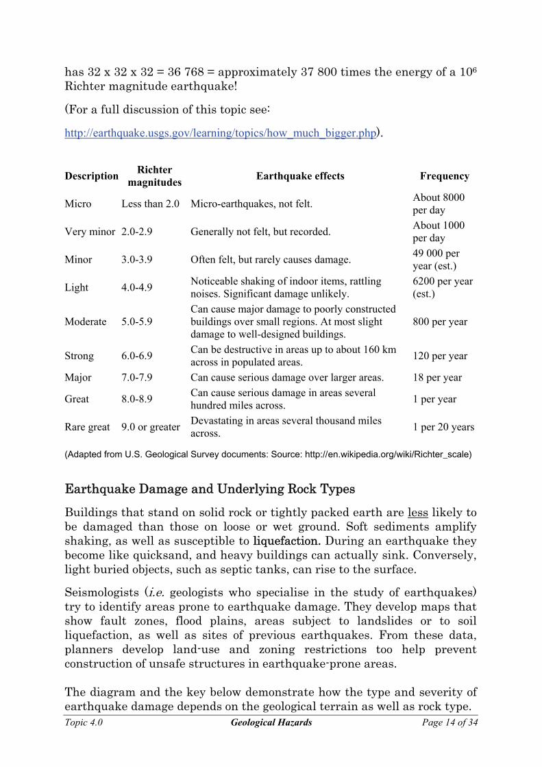
has 32 x 32 x 32 = 36 768 = approximately 37 800 times the energy of a 106 Richter magnitude earthquake!
(For a full discussion of this topic see:
http://earthquake.usgs.gov/learning/topics/how_much_bigger.php).
Description Richter magnitudes Earthquake effects Frequency
Micro Less than 2.0 Micro-earthquakes, not felt. About 8000 per day
Very minor 2.0-2.9 Generally not felt, but recorded. About 1000 per day
Minor 3.0-3.9 Often felt, but rarely causes damage. 49 000 per year (est.)
Light 4.0-4.9 Noticeable shaking of indoor items, rattling noises. Significant damage unlikely.
6200 per year (est.)
Moderate 5.0-5.9 Can cause major damage to poorly constructed buildings over small regions. At most slight damage to well-designed buildings.
800 per year
Strong 6.0-6.9 Can be destructive in areas up to about 160 km across in populated areas. 120 per year
Major 7.0-7.9 Can cause serious damage over larger areas. 18 per year
Great 8.0-8.9 Can cause serious damage in areas several hundred miles across. 1 per year
Rare great 9.0 or greater Devastating in areas several thousand miles across. 1 per 20 years
(Adapted from U.S. Geological Survey documents: Source: http://en.wikipedia.org/wiki/Richter_scale)
Earthquake Damage and Underlying Rock Types
Buildings that stand on solid rock or tightly packed earth are less likely to be damaged than those on loose or wet ground. Soft sediments amplify shaking, as well as susceptible to liquefaction. During an earthquake they become like quicksand, and heavy buildings can actually sink. Conversely, light buried objects, such as septic tanks, can rise to the surface.
Seismologists (i.e. geologists who specialise in the study of earthquakes) try to identify areas prone to earthquake damage. They develop maps that show fault zones, flood plains, areas subject to landslides or to soil liquefaction, as well as sites of previous earthquakes. From these data, planners develop land-use and zoning restrictions too help prevent construction of unsafe structures in earthquake-prone areas. The diagram and the key below demonstrate how the type and severity of earthquake damage depends on the geological terrain as well as rock type. Topic 4.0 Geological Hazards Page 14 of 34
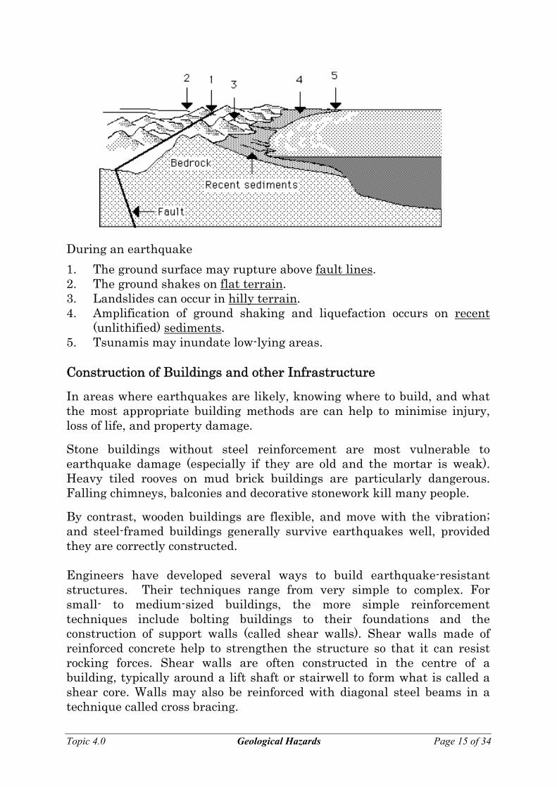
During an earthquake
1. The ground surface may rupture above fault lines. 2. The ground shakes on flat terrain. 3. Landslides can occur in hilly terrain. 4. Amplification of ground shaking and liquefaction occurs on recent
(unlithified) sediments. 5. Tsunamis may inundate low-lying areas. Construction of Buildings and other Infrastructure
In areas where earthquakes are likely, knowing where to build, and what the most appropriate building methods are can help to minimise injury, loss of life, and property damage.
Stone buildings without steel reinforcement are most vulnerable to earthquake damage (especially if they are old and the mortar is weak). Heavy tiled rooves on mud brick buildings are particularly dangerous. Falling chimneys, balconies and decorative stonework kill many people.
By contrast, wooden buildings are flexible, and move with the vibration; and steel-framed buildings generally survive earthquakes well, provided they are correctly constructed. Engineers have developed several ways to build earthquake-resistant structures. Their techniques range from very simple to complex. For small- to medium-sized buildings, the more simple reinforcement techniques include bolting buildings to their foundations and the construction of support walls (called shear walls). Shear walls made of reinforced concrete help to strengthen the structure so that it can resist rocking forces. Shear walls are often constructed in the centre of a building, typically around a lift shaft or stairwell to form what is called a shear core. Walls may also be reinforced with diagonal steel beams in a technique called cross bracing. Topic 4.0 Geological Hazards Page 15 of 34
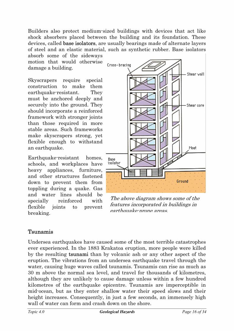
Builders also protect medium-sized buildings with devices that act like shock absorbers placed between the building and its foundation. These devices, called base isolators, are usually bearings made of alternate layers of steel and an elastic material, such as synthetic rubber. Base isolators absorb some of the sideways motion that would otherwise damage a building.
Topic 4.0 Geological Hazards Page 16 of 34
Skyscrapers require special construction to make them earthquake-resistant. They must be anchored deeply and securely into the ground. They should incorporate a reinforced framework with stronger joints than those required in more stable areas. Such frameworks make skyscrapers strong, yet flexible enough to withstand an earthquake.
Earthquake-resistant homes, schools, and workplaces have heavy appliances, furniture, and other structures fastened down to prevent them from toppling during a quake. Gas and water lines should be specially reinforced with flexible joints to prevent breaking.
The above diagram shfeatur
ows some of the es incorporated in buildings in
earthquake-prone areas. Tsunamis
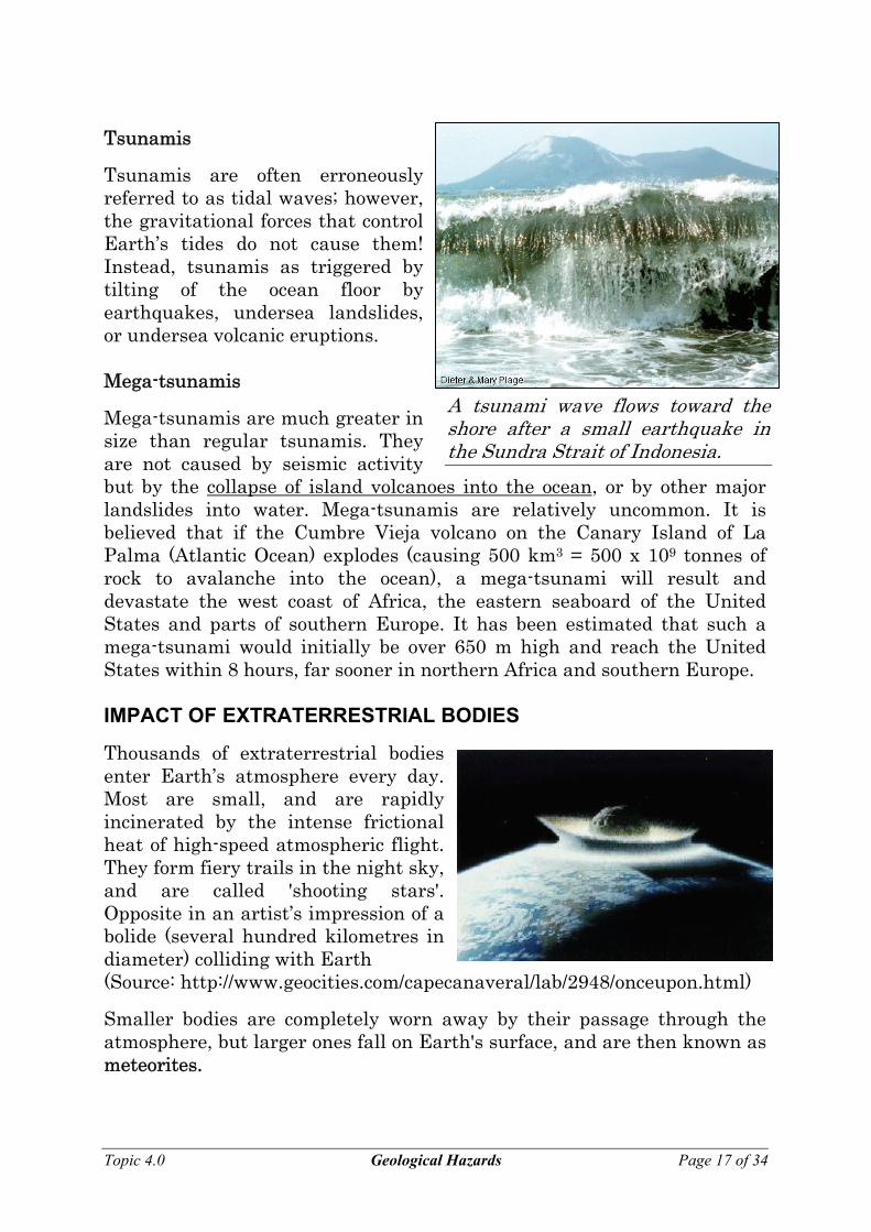
Undersea earthquakes have caused some of the most terrible catastrophes ever experienced. In the 1883 Krakatoa eruption, more people were killed by the resulting tsunami than by volcanic ash or any other aspect of the eruption. The vibrations from an undersea earthquake travel through the water, causing huge waves called tsunamis. Tsunamis can rise as much as 30 m above the normal sea level, and travel for thousands of kilometres, although they are unlikely to cause damage unless within a few hundred kilometres of the earthquake epicentre. Tsunamis are imperceptible in mid-ocean, but as they enter shallow water their speed slows and their height increases. Consequently, in just a few seconds, an immensely high wall of water can form and crash down on the shore.
Tsunamis
Topic 4.0 Geological Hazards Page 17 of 34
Tsunamis are often erroneously referred to as tidal waves; however, the gravitational forces that control Earth’s tides do not cause them! Instead, tsunamis as triggered by tilting of the ocean floor by earthquakes, undersea landslides, or undersea volcanic eruptions. Mega-tsunamis
Mega-tsunamis are much greater in size than regular tsunamis. They are not caused by seismic activity but by the collapse of island volcanoes into the ocean, or by other major landslides into water. Mega-tsunamis are relatively uncommon. It is believed that if the Cumbre Vieja volcano on the Canary Island of La Palma (Atlantic Ocean) explodes (causing 500 km3 = 500 x 109 tonnes of rock to avalanche into the ocean), a mega-tsunami will result and devastate the west coast of Africa, the eastern seaboard of the United States and parts of southern Europe. It has been estimated that such a mega-tsunami would initially be over 650 m high and reach the United States within 8 hours, far sooner in northern Africa and southern Europe.
A tsunami wave flows toward the shore after a small earthquake in the Sundra Strait of Indonesia.
IMPACT OF EXTRATERRESTRIAL BODIES
Thousands of extraterrestrial bodies enter Earth’s atmosphere every day. Most are small, and are rapidly incinerated by the intense frictional heat of high-speed atmospheric flight. They form fiery trails in the night sky, and are called 'shooting stars'. Opposite in an artist’s impression of a bolide (several hundred kilometres in diameter) colliding with Earth (Source: http://www.geocities.com/capecanaveral/lab/2948/onceupon.html)
Smaller bodies are completely worn away by their passage through the atmosphere, but larger ones fall on Earth's surface, and are then known as meteorites.
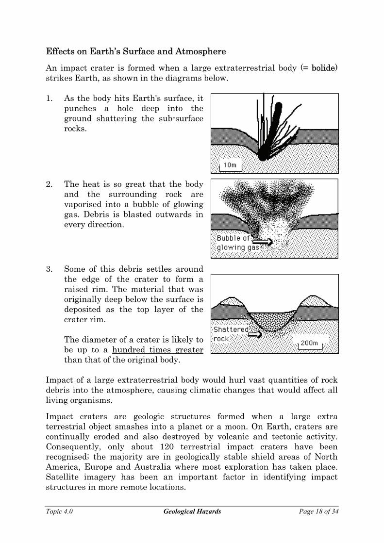
Effects on Earth’s Surface and Atmosphere
An impact crater is formed when a large extraterrestrial body (= bolide) strikes Earth, as shown in the diagrams below. 1. As the body hits Earth's surface, it
punches a hole deep into the ground shattering the sub-surface rocks.
2. The heat is so great that the body and the surrounding rock are vaporised into a bubble of glowing gas. Debris is blasted outwards in every direction.
3. Some of this debris settles around the edge of the crater to form a raised rim. The material that was originally deep below the surface is deposited as the top layer of the crater rim.
The diameter of a crater is likely to
be up to a hundred times greater than that of the original body.
Impact of a large extraterrestrial body would hurl vast quantities of rock debris into the atmosphere, causing climatic changes that would affect all living organisms.
Impact craters are geologic structures formed when a large extra terrestrial object smashes into a planet or a moon. On Earth, craters are continually eroded and also destroyed by volcanic and tectonic activity. Consequently, only about 120 terrestrial impact craters have been recognised; the majority are in geologically stable shield areas of North America, Europe and Australia where most exploration has taken place. Satellite imagery has been an important factor in identifying impact structures in more remote locations. Topic 4.0 Geological Hazards Page 18 of 34
Explore 50 of Earths most significant craters using this site:
http://geology.com/meteor-impact-craters.shtml
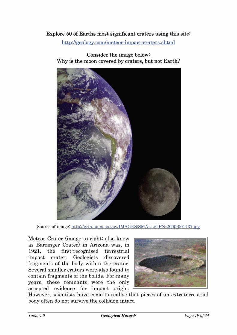
Consider the image below: Why is the moon covered by craters, but not Earth?
Source of image: http://grin.hq.nasa.gov/IMAGES/SMALL/GPN-2000-001437.jpg Meteor Crater (image to right; also know as Barringer Crater) in Arizona was, in 1921, the first-recognised terrestrial impact crater. Geologists discovered fragments of the body within the crater. Several smaller craters were also found to contain fragments of the bolide. For many years, these remnants were the only accepted evidence for impact origin. However, scientists have come to realise that pieces of an extraterrestrial body often do not survive the collision intact.
Topic 4.0 Geological Hazards Page 19 of 34
In massive bolide collisions, enormous pressures and temperatures are generated that can vaporise the body, or can completely melt and mix it with molten target rocks. Over thousands of years, any detectable component of the body may erode away. In some cases, heavy elements such as iridium (which are found in metal-rich interiors of chemically segregated asteroids and planets) can be detected in the impact melt rocks within large craters. These elements are extremely rare on Earth's surface and therefore provide a chemical signature and evidence of an extraterrestrial impact.
Since the 1960s, numerous studies have uncovered another physical marker of impact structures - shock structures! Certain shock structures have been shown to be uniquely and unambiguously associated with impact craters. No other earthly mechanism (including volcanism) produces the extremely high pressures required to create them. They include quartz and feldspar grains containing multiple sets of microscopic joint planes, and rare minerals that are formed under extreme high-pressure conditions. All known terrestrial impact structures exhibit some or all of these shock effects.
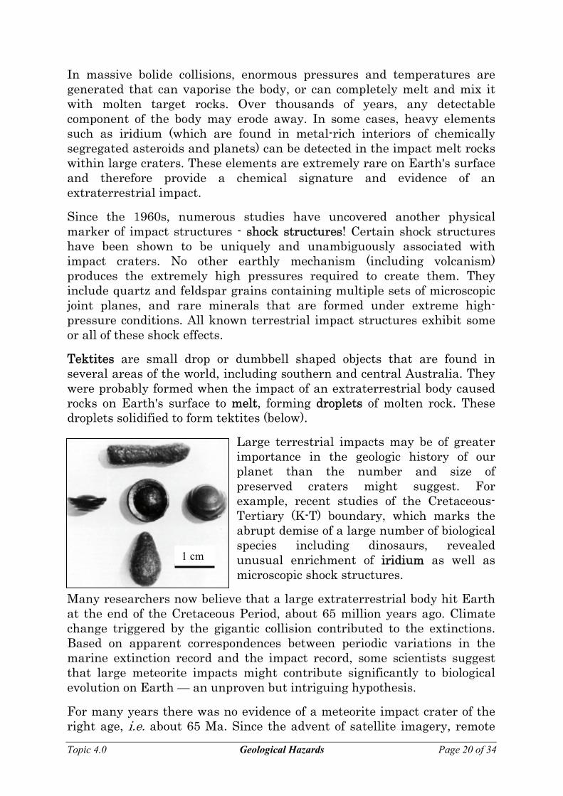
Tektites are small drop or dumbbell shaped objects that are found in several areas of the world, including southern and central Australia. They were probably formed when the impact of an extraterrestrial body caused rocks on Earth's surface to melt, forming droplets of molten rock. These droplets solidified to form tektites (below).
Large terrestrial impacts may be of greater importance in the geologic history of our planet than the number and size of preserved craters might suggest. For example, recent studies of the Cretaceous-Tertiary (K-T) boundary, which marks the abrupt demise of a large number of biological species including dinosaurs, revealed unusual enrichment of iridium as well as microscopic shock structures.
1 cm
Many researchers now believe that a large extraterrestrial body hit Earth at the end of the Cretaceous Period, about 65 million years ago. Climate change triggered by the gigantic collision contributed to the extinctions. Based on apparent correspondences between periodic variations in the marine extinction record and the impact record, some scientists suggest that large meteorite impacts might contribute significantly to biological evolution on Earth — an unproven but intriguing hypothesis.
For many years there was no evidence of a meteorite impact crater of the right age, i.e. about 65 Ma. Since the advent of satellite imagery, remote
Topic 4.0 Geological Hazards Page 20 of 34
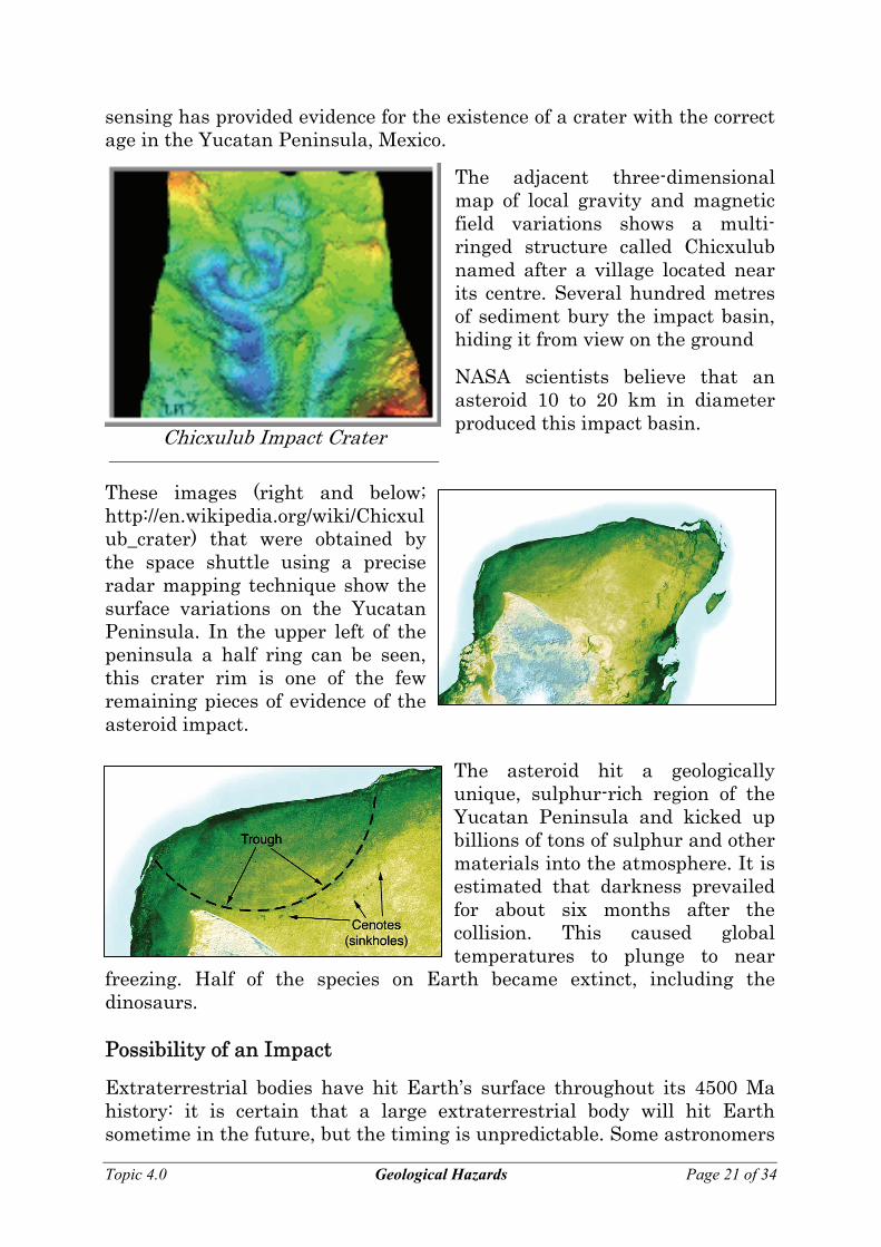
sensing has provided evidence for the existence of a crater with the correct age in the Yucatan Peninsula, Mexico.
The adjacent three-dimensional map of local gravity and magnetic field variations shows a multi-ringed structure called Chicxulub named after a village located near its centre. Several hundred metres of sediment bury the impact basin, hiding it from view on the ground
NASA scientists believe that an asteroid 10 to 20 km in diameter produced this impact basin. Chicxulub Impact Crater
These images (right and below; http://en.wikipedia.org/wiki/Chicxulub_crater) that were obtained by the space shuttle using a precise radar mapping technique show the surface variations on the Yucatan Peninsula. In the upper left of the peninsula a half ring can be seen, this crater rim is one of the few remaining pieces of evidence of the asteroid impact.
The asteroid hit a geologically unique, sulphur-rich region of the Yucatan Peninsula and kicked up billions of tons of sulphur and other materials into the atmosphere. It is estimated that darkness prevailed for about six months after the collision. This caused global temperatures to plunge to near
freezing. Half of the species on Earth became extinct, including the dinosaurs. Possibility of an Impact
Extraterrestrial bodies have hit Earth’s surface throughout its 4500 Ma history: it is certain that a large extraterrestrial body will hit Earth sometime in the future, but the timing is unpredictable. Some astronomers
Topic 4.0 Geological Hazards Page 21 of 34
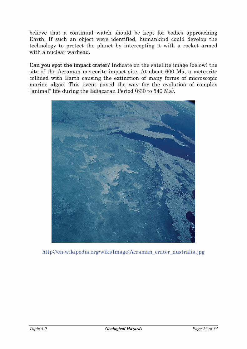
believe that a continual watch should be kept for bodies approaching Earth. If such an object were identified, humankind could develop the technology to protect the planet by intercepting it with a rocket armed with a nuclear warhead. Can you spot the impact crater? Indicate on the satellite image (below) the site of the Acraman meteorite impact site. At about 600 Ma, a meteorite collided with Earth causing the extinction of many forms of microscopic marine algae. This event paved the way for the evolution of complex “animal” life during the Ediacaran Period (630 to 540 Ma).
http://en.wikipedia.org/wiki/Image:Acraman_crater_australia.jpg
Topic 4.0 Geological Hazards Page 22 of 34
EXERCISES
VOLCANIC ACTIVITY
1. Describe the essential features of the magma that produces lava flows (without violent or explosive activity).
2. What types of volcanoes are least explosive?
3. Explain why it is rare for people to be killed by lava flows.
4. Explain why volatiles in andesitic magma are particularly dangerous.
5. Describe the behaviour and some of the effects of volatiles as andesitic magma approaches Earth’s surface.
6. What are pyroclastic materials?
7. Discuss some of the effects of pyroclastic materials on the atmosphere.
8. Other than lava and pyroclastic materials, what other dangerous substances may be ejected from a volcano? Give examples of their effects.
Topic 4.0 Geological Hazards Page 23 of 34
9. Most of Earth’s tectonically active areas are associated with:
10. Describe three groups into which Earth’s volcanically active can be divided.
11. Explain why prediction of volcanic activity on a worldwide basis is very difficult.
12. Name two instruments used in volcano observatories, and explain why/how each is employed.
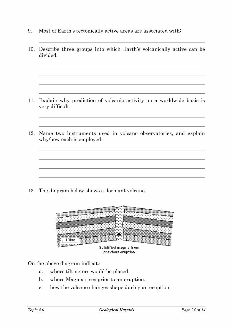
13. The diagram below shows a dormant volcano.
On the above diagram indicate:
a. where tiltmeters would be placed.
b. where Magma rises prior to an eruption.
c. how the volcano changes shape during an eruption.
Topic 4.0 Geological Hazards Page 24 of 34
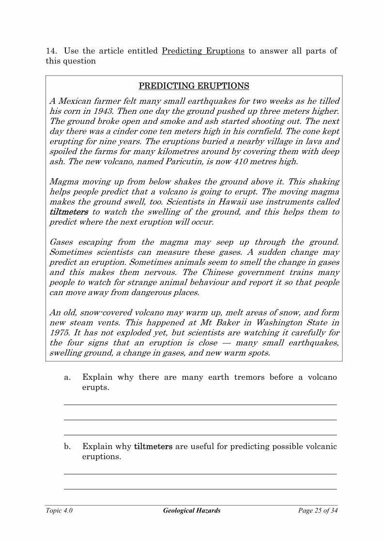
14. Use the article entitled Predicting Eruptions to answer all parts of this question
PREDICTING ERUPTIONS
A Mexican farmer felt many small earthquakes for two weeks as he tilled his corn in 1943. Then one day the ground pushed up three meters higher. The ground broke open and smoke and ash started shooting out. The next day there was a cinder cone ten meters high in his cornfield. The cone kept erupting for nine years. The eruptions buried a nearby village in lava and spoiled the farms for many kilometres around by covering them with deep ash. The new volcano, named Paricutin, is now 410 metres high. Magma moving up from below shakes the ground above it. This shaking helps people predict that a volcano is going to erupt. The moving magma makes the ground swell, too. Scientists in Hawaii use instruments called tiltmeters to watch the swelling of the ground, and this helps them to predict where the next eruption will occur. Gases escaping from the magma may seep up through the ground. Sometimes scientists can measure these gases. A sudden change may predict an eruption. Sometimes animals seem to smell the change in gases and this makes them nervous. The Chinese government trains many people to watch for strange animal behaviour and report it so that people can move away from dangerous places. An old, snow-covered volcano may warm up, melt areas of snow, and form new steam vents. This happened at Mt Baker in Washington State in 1975. It has not exploded yet, but scientists are watching it carefully for the four signs that an eruption is close — many small earthquakes, swelling ground, a change in gases, and new warm spots.
a. Explain why there are many earth tremors before a volcano
erupts.
b. Explain why tiltmeters are useful for predicting possible volcanic eruptions.
Topic 4.0 Geological Hazards Page 25 of 34
c. Why does the Chinese government train people to watch for strange animal behaviour?
d. What extra warning signs does a snow-covered volcano provide?
15. Explain why living in a volcanically active area may not be as dangerous as it would first appear.
16. Explain why the soil around volcanoes is very fertile.
17. Discuss some of the other advantages of living in a volcanically active area.
18. What steps must be taken to minimise loss of life from volcanic activity?
Topic 4.0 Geological Hazards Page 26 of 34
EARTHQUAKES 1. Describe, with the aid of diagrams, the basic cause of many
earthquakes.
2. Explain, with the aid of a diagram why earthquakes occur along mid-
ocean ridges.
3. Explain, with the aid of a diagram, why earthquake activity occurs at
conservative plate boundaries.
Topic 4.0 Geological Hazards Page 27 of 34
4. Describe and explain, with the aid of a diagram, the types of earthquake activity which are associated with subduction zones.
5. Explain, with the aid of a diagram, why earthquake activity occurs in
the Mount Lofty and Flinders Ranges, even though they are very distant from any plate boundary.
6. What is usually the primary cause of casualties in earthquakes?
7. List some of the secondary causes of earthquake casualties.
8. Name some other possible effects of earthquakes.
9. Name the type of waves that cause earthquake damage.
Topic 4.0 Geological Hazards Page 28 of 34
10. Describe, with the aid of diagrams the two types of surface waves.
11. Name the two scales which are used to measure the strength of
earthquake waves.
12. Describe the essential features of the Mercalli scale.
13. Explain the meaning of the term isoseismal lines, and draw isoseismal lines on the diagram below.
Topic 4.0 Geological Hazards Page 29 of 34
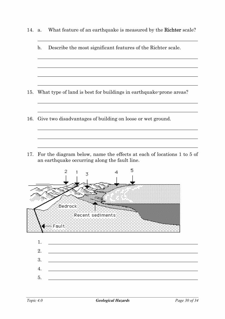
14. a. What feature of an earthquake is measured by the Richter scale?
b. Describe the most significant features of the Richter scale.
15. What type of land is best for buildings in earthquake-prone areas?
16. Give two disadvantages of building on loose or wet ground.
17. For the diagram below, name the effects at each of locations 1 to 5 of an earthquake occurring along the fault line.
1.
2.
3.
4.
5.
Topic 4.0 Geological Hazards Page 30 of 34
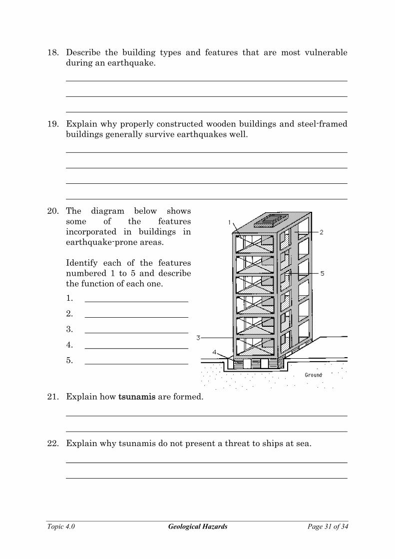
18. Describe the building types and features that are most vulnerable during an earthquake.
19. Explain why properly constructed wooden buildings and steel-framed buildings generally survive earthquakes well.
20. The diagram below shows some of the features incorporated in buildings in earthquake-prone areas.
Identify each of the features
numbered 1 to 5 and describe the function of each one.
1.
2.
3.
4.
5.
21. Explain how tsunamis are formed.
22. Explain why tsunamis do not present a threat to ships at sea.
Topic 4.0 Geological Hazards Page 31 of 34
23. What characteristics of tsunamis make them responsible for terrible catastrophes?
EXTRATERRESTRIAL BODIES 1. What happens to most extraterrestrial bodies that enter Earth’s
atmosphere?
2. What is the effect on Earth’s surface of the impact of a large meteorite?
3. Draw a labelled diagram showing the essential features of an impact crater.
5. Describe the effect on Earth’s atmosphere and climate of the impact of
a large extraterrestrial object.
6. Explain why it is often difficult to recognise impact craters.
Topic 4.0 Geological Hazards Page 32 of 34

7. Describe some features that geologists look for when identifying an impact crater.
8. Draw a diagram showing the appearance of tektites and explain how they are formed.
9. Explain why large extraterrestrial impacts may be of great interest to
the geologic history of our planet.
10. Describe a recent discovery that has supported the theory that the impact of an extraterrestrial body led to the extinction of the dinosaurs and many other life forms about 65 million years ago.
11. a. Explain why it was difficult to locate this feature.
b. What techniques eventually led to its discovery?
12. What special feature of this impact may have produced the mass extinctions?
Topic 4.0 Geological Hazards Page 33 of 34
13. a. Discuss the probability that a large extraterrestrial object will hit Earth in the near future.
b. What measures could be taken to prevent this?
Topic 4.0 Geological Hazards Page 34 of 34


![City of Colorado Springs Geological Hazards Ordinance...[New]: Final geological hazards report and plans sent back to CGS for review prior to the City’s final approval of applicable](https://img.pdfslide.us/doc/110x75/5eb428c60999970c155cae9a/city-of-colorado-springs-geological-hazards-ordinance-new-final-geological.jpg)