Embed Size (px)
Citation preview
WORKSHOP ON STRATIGRAPHIC CORRELATION OF ntAILAND AND MLAYSIA
Haad Yal, Thailand 8-10 Sept-.er, 1983
GEOLOGICAL EVOLUTION OF PENINSULAR MALAYSIA T.T. Khoo and B.K. Tan Department of Geology
University of Malaya, Kuala Lumpur
ABSTRACT
Peninsular Malaysia can be divided into 3 longitudinal belts, Western, Central and Eastern, each of which has its own distinctive characteristics and geological development. The Western Belt can be subdivided into a northwest sector and a Kinta-Malacca sector. The northwest sector is underlain by clastics, limestones and minor volcanics. The time of the Langkawi folding phase of Koopmans (1965) is revised from Devonian to mid-Permian and this phase is not only confined to southeast Langkawi but covers the whole of Langkawi and Terutao area and extends southeast into mainland Kedah forming a northwest trending belt called the Patani Metamorphics. There is some evidence for a Devonian phase of folding and uplift as well but evidence for it is not strong. The post mid-Permian saw deposition of carbonates and clastics in this sector and the whole region was uplifted by the culminating late Triassic orogenic event which affected the whole of the peninsula. In the Kinta-Malacca sector, there was deposition of argillaceous and calcareous sediments in the early Palaeozoic followed by more limestone deposition in the Kinta region but by clastics in the Kuala· Lumpur area. There is evidence for a post-Silurian event of folding and metamorphism in the Kuala Lumpur area, possibly Devonian. In the Kinta region there is scant evidence to date this tectonic event. There is no known Mesozoic sediment in this sector.
The Central Belt is underlain predominantly by Permian-Triassic clastics, volcanics and limestones. Pre-early Devonian deposition of coarse clastics, argillaceous sediments chert and other rock types occur in the marginal belt forming the foothills of the Main Range Granite. Ultramafic bodies were emplaced in this foothills belt and the who.le belt was regionally metamorphosed probably during the Devonian. The Taku Schists and adjacent areas occupy the northern part of the Central Belt and it exposes mainly schists, amphibolites and phyllites. The regional metamorphic rocks adjacent to the Taku Schists include the Triassic. Rocks assemblage inside the Taku Schists has little similarity to those of the Permian-Triassic outside and it is possible that they represent pre-Permian rocks. The Taku Schists and adja-
253
cen~ areas suffere~ up~ift, recumbent style folding and regional metamorphism dur1ng the late Tr1ass1c. In the rest of the Central Belt, this late Triassic orogenic uplift also terminated marine sedimentation. Continental deposition began soon after and continued up to the early Cretaceous. During the late Cretaceous, the continental deposits were uplifted and gently folded.
The Eastern ~elt is largely underlain by Carboniferous and Permian clastics and volcanics. A phase of regional metamorphism, folding and uplift probably occurred.in the late Palaeozoic (Permian?) followed by deposition of an older series of continental deposits such as the Murau and Redang conglomerates. The pan-peninsula late Triassic orogenic event uplifted the Eastern Belt. This was followed by deposition of a younger series of continental deposits which are only gently dipping and probably they were uplifted in the late Cretaceous.
Significant plutonic acid magmatism occurred during the early Permian, late Permian/early Triassic and the late Triassic in the Western Belt, late Triassic and late Cretaceous in the Central Belt and late Permian/early Triassic and late Triassic in the Eastern Belt. Volcanism occurred in all 3 belts. In the northwest sector of the Western Belt, acid volcanism occurred during the late Cambrian and Ordovician. In the Central Belt significant acid to andesitic volcanism occurred in the Permian and Triassic. In the Eastern Belt Carboniferous-Permian acid volcanism was widespread. After the cratonization of the peninsula, volcanic activities continued to be manifested in the late Mesozoic, early Tertiar,y and Pleistocene in the Central and Eastern Belts. The later volcanic activities tend to be basic.
Various models have been proposed to explain the 3 fold division of the peninsula and their geological features. Models involving both eastward and westward subduction at the foot of the Main Range and collision have been suggested. An aborted rift model interpreting the Central Belt to be an aborted graben has also been proposed. The suggestion that the Foothills Formation roc~s include ophiolites and tectonic melange has yet to be substantiated by field evidence. The margins of the belts are not sharp or easily delineated. Various interpretations have been suggested for the boundaries of the three belts. Sedimentological and structural characteristics of the rocks adjacent to the margins of the belts can be best explained by vertical movement along northsouth striking faults. The tectonic reconstruction of the peninsula has been and will continue to be a subject for speculation. Many of the tectonic. schemes proposed depend on a great deal of assumptions and some of the desirable features required by these schemes appear to be lacking or possibly yet to be uncovered. The geological evolution of the pen.insula needs to be considered together with the adjacent regions including onshore and offshore Thailand and Indonesia and advances in the geology of these regions can contribute to a better understanding of Peninsular Malaysian geology.
254
Si.nce the 1970s there has been a rapid increase in the geological knowledge of Peninsular Malaysia both onshore and offshore. This increase has been made possible by the expansion of activities of the Geological Survey, local universities and the petroleum and mining industries. During this period there has also been much progress in the advancement of geological knowledge of the Southeast Asian region and the science of geology itself has witnessed much development and growth in knowledge and theories. Under these favourable conditions it would appear· that efforts to reconstruct the geological evolution of Peninsular Malaysia would have been made easier. However, the opposite is nearer to the truth. More knowledge has put restraints on many tempting generalizations which one would have boldly made and in fact more knowledge has often begged for even more knowledge. Under these circumstances, this paper will give an account of the essential features of the Peninsular Malaysian geology and followed by discussions on the geological evolution (mainly tectonic) including those proposals made by various authors earlier.
DIVISION OF THE PENINSULAR MALAYSIA
One of the most significant developments in Peninsular Malaysian geology in recent years has been the general acceptance of the division of the peninsula into 3 belts each with its distinctive geologic history and evolution. This 3 fold division is not a recent observation. Based on mineralization, Scrivener (1928) proposed a division of the peninsula into a central gold belt in between tin belts to the east and west. This division has evolved into the present Central, Eastern and Western Belts respectively (Fig. 1).
As these 3 belts have contrasting geology, the marginal areas between the belts have naturally received much interest and attention. The understanding of the nature of the marginal areas is crucial to the understanding ' of the nature of these three belts. However, the demarcation of the boundaries is still problematical and a few proposals have been made. They are shown in Fig. 2. It can be seen that proposals taking the eastern foothills of the Main Range Granite to be the boundary between the Central and Western Belts and the boundary between the Central and Eastern Belts to be the western foothills of the elongate granitic plutons of Trengganu, Pahang and Johore will result in a narrowed Central Belt in the north. The southern part of the Central Belt is either wide or narrow depending on whether the Central/Western Belts boundary is extended to the southern tip of the peninsula or into the Straits of Malacca at northwest Johore.
The boundary of the Central/Western Belts has also been drawn joining occurrences of serpentinite bodies in the rock formations (the so-called Foothills Formation, Bentong Group, etc) forming the eastern foothills of the Main Range Granite. This line is called the Bentong-Raub line by Hutchison (1975, ·~977). Extensions of this line north and south are speculative as serpentinite bodies have not been reported iri those areas. In another interpretation Tan (198la) found that the serpentinite occurrences in Peninsular Malaysia define two linear zones, one on the eastern side and one on the western side of the Central Belt (Fig. 3). It should be noted that in this later interpretation the zones cut across granite and coin-
255
cide with occurrences of large approximately north-south trending fault zones.
From the above, it is clear that at the present state of knowledge, there is no clear agreement on how the three belts should be demarcated although the three belts are apparent. However, the importance of the marginal areas of these three belts are undiminished.
Besides the 3 main longitudinal divisions mentioned above, a few authors also recognized other divisions. Hutchison (1977) recognized a Western Stable Shelf comprising areas on the far northwest of the peninsula (Langkawi and part of Penang). Tjia (1978) divided the peninsula into various structural domains based on structural trends. Recent studies indicate that the geology of northwestern peninsula comprising the State of Kedah, Perlis and possibly including north Perak has distin~tive differences from the rest of the Western Belt. These differences will be pointed out in the discussion on the characteristics of each of the belts to be given below.
CHARACTERISTICS OF THE BELTS
STRATIGRAPHY
Western Belt The whole tract of the Western Belt .from the Kinta Valley southwards
to Malacca is underlain predominantly by Palaeozoic rocks. In the Kinta Valley, relatively thick limestones predominate and they range from Silurian to Permian. The stratigraphic record from Kampar does not indicate any break in deposition from Devonian to Permian (Suntharalingam, 1968). In the Kuala Lumpur area relatively thick limestone of Silurian age occurs and it is overlain by a mudstone-sandstone sequence of unproven age but popularly believed to be Upper Palaeozoic. The sequence, the Kenny Hill Formation is widespread in Selangor and may even be present in Malacca. Else}'lhere in this tract, schists, phyllites, quartzites, some volcanics and rare limestones occur. One of the limestone lenses in schists in the Tanjung Malim area has yielded Ordovician fossils (Kobayashi and others, 1979).
The part of the Western Belt in northwest Malaya comprising of Kedah, P~rlis and north Perak on the whole has a rather different stratigraphic history compared to the area mentioned above. In the Langkawi-Perlis area, the Lower Palaeozoic is represented by Upper Cambrian arenaceous Machinchang Formation succeeded conformably in the Ordovician-Silurian by the Setul Formation which is largely limestone with detrital bands. In Pulau Langgun the top of the Setul Formation is a detrital band of Lower Devonian age which is made up·of layers of poorly fossi.liferous detrital rocks. Fossiliferous red mudstone of Upper Devonian - Lower Carboniferous age overlies unfossiliferous bands. It is uncertain whether an unconformity exists immediately below the red mudstone. This red mudstone has been taken to be the base of the succeeding Singa Formation which is made up of mudstone, sandstone (some calcareous) and occasional rather thin horizons of pebbly mudstones. The pebbles a.nd rare boulders have been interpreted to be glacial drop-
256
stones by some and as slump deposits by others. The Singa Formation is believed to be largely Carboniferous as it is succeeded by the fossiliferous Permian limestone formation called the Chuping. In much of Perlis and north Kedah, clastic rocks unlike the Singa Formation occur above the Setul Formation and these rocks called the Kubang Pasu Formation have been found to range from Upper Devonian to Lower Permian. The Kubang Pasu Formation is overlain conformably by the Chuping limestone.
In the rest of mainland Kedah the stratigraphy is again different. The oldest strata are those of the Jerai Formation which is believed to be comparable to the Machinchang Formation. It is made up of a lower· schist series and an upper arenaceous series. This is succeeded by argillaceous rocks classified as Sungai Patani Formation by Bradford (1972). In Pulau Bidan, off Gunung Jerai, thin fossiliferous limestone of possible Ordovician-Silurian age occurs. The Setul Formation clearly disappeared towards the south and east. The Sungai Patani Formation was later classified as Mahang Formation which is exposed further southeast. The Mahang Formation is made up of black mudstone of Silurian toproba~e Lower Devonian age.
In the eastern part of Kedah and north Perak, Lower Palaeozoic rocks of limestones and metasediments occur. In north Perak, volcanics, and quartzites also occur.
Over much of north Kedah, south Kedah and the Semanggol area of north Perak, marine Triassic arenaceous and argillaceous rocks with chert bands occur. These rocks have turbidite characteristics. In the Muda Dam area of eastern Kedah, this sequence called the Semanggol Formation underlies a sequence of probable post-Triassic redbeds unconformably. The contacts between the Semanggol and older formations are interpreted to be faults. In addition isolated occurrences of Triassic limestones are also known in north Kedah.
The Tertiary rocks in the whole of the Western Belt are represented by small basinal rocks of shale and other clastics with coal bands.
Central Belt Unlike the Western Belt which is largely underlain by Palaeozoic rocks,
the Central Belt is largely underlain by rocks of the Mesozoic and Permian. The oldest rocks in the Central Belt are those bordering the eastern flank of the Main Range Granite. The rocks here have been variously called e.g. Foothills Formation, Bentong Group, etc. They consist of schists, amphibolites, conglomerates and other clastics and small bodies of serpentinite associated with the schists. Rocks at the top of this group of rocks have yielded Devonian and Silurian graptolites. Elsewhere some Carboniferous rocks are exposed in Kuala Lipis and the Taku Schists may include metammorphosed Carboniferous or older rocks. Marine Permian and Triassic rocks cover the greater part of the Belt. They are represented by shale, mudstone, fine sandstone, limestone and volcanics. There is no evidence that these ~cks are not conformable. In the late Triassic, the marine rocks gave way to deposition of continental deposits of the Tekai Group ranging from Jurassic - Cretaceous.
257
Minor continental basinal deposits of clastics with coal horizons occur similar to the Western Belt.
Eastern Belt The older sediments in the Eastern Belt are essentially Carboniferous
and Permian clastics, limestone and volcanics. low grade schists also occur. There is lack of evidence for Triassic sediments occurring. Unconformable on the older Carbonifeorus and Permian sediments are continental deposits of Jurassic - Cretaceous age such as the Gagau Group.
MAGMATISM
Western Belt There is little evidence of extrusive magmatism in the part of the Wes
tern Belt from the Kinta Valley south to Malacca except for the minor occurrences of volcanics among the rocks bordering the Main Range Granite. In the north-western sector, however, tuffaceous rocks are known as interbeds in the Machinchang Formation and in the Lower Palaeozoic rocks of north Perak, volcanics are common. These volcanics are acidic.
The oldest intrusive rocks are probably represented by high level quartzporphyry bodies in the Jerai Formation and in the nearby island of Pulau Bunting. It is possible that these are the unextruded equivalents of the tuffaceous rocks in the Upper Cambrian Machinchang Formation.
The main intrusive body in the belt is the Main Range Granite and the very many granitic plutons elsewhere in the Belt. From Rb:Sr and K:Ar geochronological studies, Bignell and Snelling (1977a) suggest the occurrence of various granitic intrusion episodes - probable Devonian, Upper Carboniferous (now this 280 Ma event is revised to early Permian), Upper Permian/ Lower Triassic and Upper Triassic. The interpretation of these ages are being questioned by many workers and one of the reasons is that individual granite plutons have not been mapped. Bignell and Snelling (1977a) found that the granites have high initial 87Sr: 86Sr ratios ranging from 0.710-0.717. The high ratio is interpreted to be due to high differentiation. The granites of the Main Range are often, but not always, characterized by the occurrence of large potash feldspars (maximum microcline). Th~ are largely biotite granite and adamellite without hornblende although some hornblende may be present due to contamination (Santokh Singh and Yong, 1982).
Compared to the acid magmatism, mafic and ultramafic activities are scarce. Small maf1'c bodies are found·in Kedah cutting the Jerai sandstone and Carboniferous sediments. In Malacca, serpentinite has been discovered (Khoo, 1978; Tan, 1982) and recent mapping and geophysical studies indicate a sizable body including possibly .gabbroic rocks occurring around the Teluk Mas area. Serpentinite is also reporte~ in north Perak by Jones (1970).
258
Central Belt In contrast to the Western Belt, volcanism is very significant in the
Central Belt. Volcanic rocks from acidic to andesitic compositions are common among the Permian and Triassic marine sediments. Some volcanics are also known in the rocks of the Foothills Formation. During the early Tertia·ry, an epi.sode of mafic magmatism gave rise to basaltic flows in Segamat.
Intrusives of mafic and ultramafic are more abundant in the Central Belt than in the Western Belt. Serpentinite bodies of various sizes, but generally not extensive, are found in the metamorphics of the Foothills Formation in Raub, Bentong and Bahau areas. The serpentinites are believed to be derived from ultramafic.rocks such as pyroxenites. Besides the occurrences mentioned, metamorphosed pyroxenites occur in the western foothills of Gunung Benom together with mafic plutonic rocks such as gabbro and also syenites. On the eastern flanks of the Central Belt serpentinite occurrences are also·known.
Of particular interest in the Central Belt is the occurrence of a northsouth trending belt of granitic intrusives with minor syenitic bodies ex-tending from the Thai border all the way south towards Johore. This belt · occurs close to the western side of the Central Belt. The granites are I biotite-bearing and intrudes Triassic sediments. Bignell and Snelling (1977a) gave an Upper Triassic age for the Benom granite which is in accord with the geology. Younger granites are also known in this belt with the Gunung Ledang granite dated to be Upper Cretaceous (Yap, 1981) and Upper Cretaceous ages have also been obtained from Kelantan (Bignell and Snelling, 1977a). The Benom granite was found to have an ~Sr: 86Sr initial ratio of 0.708, only slightly lower than the Main Range Granites.
Eastern Belt Similar to the Central Belt, volcanism is very significant in the Eastern
Belt especially of the acid type. The volcanics range from Carboniferous to Permian. In some places, the volcanics are continental ignimbritic. After cratonization, volcanism was still active and continental deposits of the Gagau Group have volcanic interbeds. Volcanic activities reappeared again in the Pleis.tocene with extrusion of various types of basaltic rocks in the Kuantan area.
Mafic intrusives of pre-granite ages occur in several places such as Linden Hill .in Johore, Pulau Tioman and in Bukit Kemuning, Trengganu. The bodies are gabbroic and accompanied by more intermediate types such as diorite. Rocks of the Eastern Belt are commonly intruded by doleritic sheets of various ages e.g. Jurassic and Cretaceous (Bignell and Snelling, 1977b). Some of them are synplutonic with their granite hosts.
Granites are abundant in the Eastern Belt and form elongated north-south bodies. They are commonly biotite granite but occasionally hornblendebearing. These granites are different from the Main Range Granite in the absence of large potash feldspar crystals. The potash feldspars in the
259
Eastern Belt granites are usually intermediate microcline. According to Bignell and Snelling (1977a), the granites have concordant K:Ar and Rb:Sr ages and they fall into 2 main groups - late Permian/early Triassic and late Triassic. The Eastern Belt granites have lower initial 87Sr: 85 Sr ratio averaging 0. 708 compared 1D the 0.710 - 0717 ratio of the Main Range Granite.
METAMORPHISM
Western Belt In the tract of the Western Belt from Kinta Valley to Malacca, the rocks
bordering the Main Range Granite have been metamorphosed to schists, quartzites, phyllites and metavolcanics of low grade. The limestones in the Kinta Valley and Kuala Lumpur areas have ~lso been largely recrystallized to marble. In some places it is clear that the marble has been contact metamorphosed by adjacent granites but the extent of the effects of regional metamorphism on the limestones is uncertain. It is also uncertain when the schists and phyllites bordering the Main Range were metamorphosed. A Devonian or younger event is possible.
In northwest Peninsular Malaysia, the rocks of north Perak and Baling have similarly been metamorphosed to low grades (Jones, 1970; Burton, 1970). The Mahang Formation in the type area of Dublin Estate, however, has not been metamorphosed. But further northwest, the northwest trending terrain of the Patani Metamorphics (Khoo, 1980 and 198la) extend up to Langkawi and Terutau (Fig. 4). The Patani Metamorphics consist of low grade phyllites and slates with one or more cleavages at low angle to bedding. Higher grade types of Patani Metamorphics may contain chloritoid and pyrophyllite. Adjacent to granitic intrusives contact metamorphic effects elevate them to biotite schists and even sillimanite-bearing rocks. The youngest rocks affected are rocks of the Singa Formation and its effects are not detected in the overlying Chuping limestone. The metamorphism probably ended in mid-Permian.
Central Belt The rocks of the Central Belt bordering the Main Range Granite are also
metamorphics such as pelitic schists phyllites and amphibole schist. The largest tract of regional metamorphic rocks in the Central Belt is the Taku Schists in north Kelantan. The terrain is even much larger if the low grade phyllites bordering the Taku Schists are included. As defined by MacDonald (1967) the Taku Schists border is actually of the biotite grade or higher. The Taku Schists including the enveloping rocks show a succession from chlorite to biotite and garnet zones and this can be mapped in the Manek Urai area (Lim and Khoo, 1976). Higher grade kyanite and sillimanite rocks also occur. The type of metamorphism is the Barrovian type. Late intrusives contact metamorphosed the rocks in places giving rise to andalusite (MacDonald, 1967).
It is interpreted that rocks of the Triassic are also metamorphosed in the enlarged Taku Schists. As the rock assemblage is predominantly pelitic schists with subordinate amphibolites, which is dissimilar to the adjacent Central Belt rocks of limestone, clastics and acid volcanics, it is in-
260
terpreted that the exposed Taku Schists rocks are older. than Permian. K:Ar ages of rocks from the Taku Schists indicate that metamo~phism ended by the late Triassic.
Elsewhere in the Central Belt, low grade metamorphics of slates and phyllites are often encountered. Sometimes even higher grade rocks such as amphibolites are e~osed. It is uncertain how these rocks occur and it is possible that they could be upfaulted. Exposures are too scarce to be definite. In general, throughout the Central Belt low grade metamorphics are not uncommon.
Eastern Belt The Carbonferous-Permian rocks of the Eastern Belt are occasionally low
grade metamorphics. In Trengganu slate and argillites are common but in Johore the grade may be higher and phyllites and schists occur.
STRUCTURES
The structures of all the 3 belts are in general complex and their interpretations are made more difficult by lack of exposures. Major fault structures are not easily detected in the field and aerial and satellite photographs have aided the discovery immeasurably.
Western Belt In the rocks bordering the Main Range from Kinta Valley to Malacca, the
low grade metamorphics show many complex fold structures which a~e not easily interpreted. At least 2 phases of deformation can be deduced in some instances. The limestones in the Kinta Valley also show complex folding especially in the thinner bedded sequences. In the Kuala Lumpur area, the thickly bedded limestones usually do not display complex fold features.but the overlying clastic sequence developed cleavages and show tight folding including recumbent fold style.
Major faulting is interpreted to bound the north Kinta Valley (Gobbett, 1971}. In the Kuala Lumpur area, the most prominent fault is the Kuala Lumpur - Kota Tinggi fault zone which is interpreted to be a wrench fault (Stauffer, 1968}. It trends northwest cutting across the Main Range Granite and extends across north Kuala Lumpur towards the Straits of Malacca. A . prominent quartz reef has been emplaced into parts of this fault zone.
In the northwestern sector of the peninsula the relation between folding and metamorphism is clearer. In the Langkawi area, it was shown by Koopmans (1965} that the southeast part of the area has suffered two phases of deformation - an early phase of recumbent folding with development of flat-lying cleavages and a later phase of open folding. Recent studies ~ave shown that this observation is not confined to the southeast of Langkawi but throughout Langkawi and Teratau. The folding and associated cleavages are present in all the layered rocks except the Chuping limestone and is characteristic of all the metamorphic rocks in the Patani Metamorphics terrain. In the Singa Formation recumbent folds can be seen with associa-
261
ted flat-lying cleavages e.g. Teluk Air Kaca, Pulau Singa. The Setul limestone also show recumbent folding and detrital bands in it are strongly cleaved and become phyllitic or schistose on coarsening due to contact metamorphism by late granites.
Faulting in Langkawi and Eastern Kedah is supposedly better known. In Langkawi, recent studies have questioned the interpretation of the existence of the Kisap thrust (Tan, 1981b). It is possible that high angle reverse faulting may be present in Langkawi e.g. at southern end of Pulau Dayang Bunting. Several faults in Langkawi are conjectural and do not stand critical examination •. In eastern Kedah, the Bok Bak Fault system is an important structural element. In addition to wrenching i~ has prominent vertical movements. The fault system is post-granite and recent studies indicate that the Bok Bak is part of a larger system of northwest trending faults (Raj, 1982). Pre-dating the Bok Bak wrench system are probable normal block faultings which forp1 the contacts between the Semanggol and Mahang Formations.
Central Belt The marginal areas of the Central Belt undoubtedly had been subjected
to major north-south trending faulting (Fig. 5). From satellite and air photographs several large north-south trending faults have been interpreted at the western marginal areas. The contributions of these major faults to the tectonic development of the peninsula will be discussed later in the paper. Some of the faults extend into peninsular Thailand. Tjia (1972) has also reported the presence of a major north-south trending Karak-Kelau fa~lt in the western marginal area.
The north-northwest trending Lepa~ fault zone near the eastern margins of the Belts is an important structural feature. Further nerth is the Lebi~ fault zone wHch follows the Lebir valley. Even though the evidence used to establish the Lebir fault has not been entirely satisfactory, nevertheless the zone could well be an older structure probably developed in the pre-late Triassic with later rejuvenating movements.
The pre-continental rocks in the Central Belt have undoubtedly been folded but the deformation histo~ has yet to be studied in detail. It has often been suggested e.g. Gobbett (1973) that the rocks have been isoclinally folded based solely on the field observation of a thick and possibly repeated sequence of rocks dipping in a particular direction. In general, the regional strike of the rocks is north-south with moderate to steep dips either towards east or west. The regional strike of strata may be distorted around late high level plutons such as the Ranjut syenite in west Pahang.
The Taku Schists appear to have undergone a phase of recumbent folding coeval with metamorphism and another phase of open folding after the complex has been metamorphosed. The late folding resulted in the complex forming a plunging antiformal structure with a north-south fold axis. This phase of late folding may be coeval with the folding of the Tekai Group.
The Tekai Group.has been folded into open broad folds with limbs dipping gently. The fold axes are north-south similar to the Taku Schists antiform.
262
The folding could well be during the late Cretaceous considering the age of the sediments and the undefonried nature of the Segamat basalt ·which i"s early Tertiary.
Eastern Belt Folding of rocks in the Eastern Belt is complex. The Carboniferous
Permian rocks in Pahang and Trengganu are generally strongly folded and this is complicated by common occurrence of slumping and soft-se·diment deformation (Yap and Tan, 1980}. The metasediments in Mersing area have been noted to show refolding.
Structurally there appears to be 2 groups of continental deposits in the Eastern Belt. There is an older group which is generally steeply dipping such as the Murau conglomerate in Mersing and the conglomerates in Pulau Redang. The pebbles in the conglomerate in the latter locality in particular show deformation with development of •ball-and-socket• structures. The Redang conglomerates are interbedded with black slates containing Pecopteris probably indicating an Upper Palaeozoic age. The Murau conglomerate 1s likely to be coeval with ignimbritic volcanics of ~~rsing and Tioman and is likely to be Upper Palaeozoic as well. On the other hand, the younger group of continental deposits is represented by the Gagau Group, Tebak Formation and others which are generally rather flatlying. This younger group is Jurassic-Cretaceous and coeval with the Tekai Group of the Central Belt. The difference in fold style of the JurassicCretaceous sediment of the Eastern and Central Belts is probably due to the relative stability of the Eastern Belt basement compared to the more mobile Central Belt during the late Cretaceous.
Faulting is common as in the other two belts. In the north Johoresouth Pahang area, a series of northwest trending faults occurs. These faults have been speculated to be the continuation of the Kuala Lumpur -Kota Tinggi fault zone. The development offshore of the Malay and Penyu Basins which are fault bounded is likely to have profound effects on the mainland. For example the extrapolation of the northe-ll'n bounding fault of the Penyu Basin, comes ashore at the area of the Kuantan Basalt (Fig 6) and it is possible that the deep fault could have resulted in the outpouring of abundant basalt in the area. There is also a possibility that the extens1ve evidence of Holocene higher sea-levels may be due to the tectonic uplift of the eastern margins of the Eastern Belt due to offshore basins development. A raised coral reef in Pulau Tioman could well have been uplifted about 8 m if it is taken that the reef developed under 5-6 m of crystal clear water the depth at which much reefs can be found in the sea around Tioman today (Khoo, 1977). A significant stranding level such as this will favour tectonism.
GEOLOGICAL DEVELOPMENT OF THE BELTS
In this section the geological development and history of the belts will be briefly given and discussed. In this account each belt will be considered without any relation to the other belts. Although it would be desi-
263
rable to relate how the development in each belt affects adjacent belts here it will only be attempted when possible.
Western Belt
(a) Kinta Valley-Malacca In the Kinta Valley and areas south of it, relatively little is known
as regards its geological evolution notwithstanding it being one of the largest mineralized areas in the peninsula. The basement for this region is not known or exposed. The oldest known sediments to be deposited appears to be carbonaceous argillaceous rocks of the Ordovician which may later be metamorphosed to black schists. Other clastics interbeds could well be of similar age. The Silurian to Permian saw deposition or relatively thick limestones in the Kinta. In the Kuala· Lumpur area the Silurian is caltareous. These calcareous sediments are evidently shelf-type and coralline types in Kampar and Kuala Lumpur may well be reefal. The fauna suggest warm water environments from the Silurian to Permian in the Kinta Valley and probably the rest of this tract of the Western Belt as well.
Evidence from studies of limestones in Kampar does not suggest any break in deposition from early Devonian to mid-Permian according to Suntharalingam (1968) and this view is currently accepted. However, in the Kuala Lumpur area, there is a possibility of a depositional break due to uplift and erosion during the Palaeozoic. The clastic Kenny Hill formation overlying the Upper Silurian Kuala Lumpur limestone has been observed to be unconformable by Yeap (1970) and studies of drill core sections passing from the Kenny Hill into the limestone by Dr. J.K. Raj (per. com.) have resulted in the same conclusion. Furthermore, the Kuala Lumpur limestone and its underlying metasediments appear to be much more metamorphosed than the Kenny Hill which has developed only weak cleavages. It is difficult to comment on the time of uplift of the Kuala Lumpur limestone as the age of the Kenny Hill has not been ascertained. However, the uplift is clearly post-Silurian, perhaps in the late Palaeozoic. This post-Silu·rian event also marked the termination of regional metamorphism and its accompanying deformation phases.
From the above, it may be further speculated that during the early Palaeozoic ultramafics and mafic rocks were emplaced in Malacca and these were regionally metamorphosed to meta-gabbro, amphibolite and serpentinite during the post-Silurian event.
No Triassic sediments are known in the tract of the Western Belt from the Kinta Valley southwards. An interpretation for this absence of Triassic rocks could be that this sector has been uplifted area during the Triassic. The uplift probably preceded by deformation could have been initiated in the late Permian as the youngest known sediment is mid-Permian. Another interpretation would be that all the Triassic sediment present had been eroded away and the area was uplifted after the Triassic.
The timing and effects of granitic intrusions pose further problems and presents interesting areas for researc~. The ages of granites proposed by Bignell and Snelling (1977a) have a few coincidences.
264
a. The post-Silurian uplift and end of metamorphism and possible Devonian and Lower Permian granites.
b. Probable end of marine carbonate sedimentation in the mid-Permian followed by uplift and the possible Upper Permian/Lower Triassic granites.
c. Probable sedimentation through the Triassic followed by postTriassic uplift and the Upper Triassic granites.
These coincidences may well have some significance but more data is required to appreciate the significance, if any.
The question of when the uplift of the Main Range Granite took place is another vexing question in need of urgent answers. Assuming that most of the granites have been emplaced during the late Triassic and this is followed by uplift, then one may ask where 1he products of erosion are to be found. The lack of Jurassic-Cretaceous and Tertiary sediments in the Kinta Valley-Malacca tract is conspicuous. The sediments could have been deposited further off, such as in Sumatra, but we do not have good evidence for this suggestion. Much of the Quaternary alluvium in the Kinta and Selangor Tin Fields evidently have been derived from granitic terrains and their covers. Are the alluvial deposits the result of the earliest stripping of the granites? If so, we may have to work on a more recent date for the uplift of the granites such as the Tertiary!
(b) Langkawi-Perlis As pointed out earlier, the northwest sector of the peninsula has a
different evolution compared to the other part of the Western Belt. In the Langkawi-Perlis area, Upper Cambrian deltaic-shallow marine arenaceous deposits of the Machinchang Formation are followed by thick Ordovician-Silurian Setul limestone. This shows a deepening of the basin of deposition. The basement or source of the arenaceous deposits is nowhere exposed. As a result, speculations are rife regarding the possible sources and a westerly sounoe is often sought - India, Africa and Gondwanaland have been suggested at one time or another. One of the reasons w~ such suggestions have been made is obviously the occurrence of the arenaceous deposits to the far west of Langkawi. However, this interpretation would not explain the occurrence of the Jerai Formation on the mainland and the Papulut quartzite further east in north Perak. All these deposits are coeval and it would be inconceivable for the deltaic-shallow marine facies to be so extensive from the supposed shoreline just to the west of the Machinchang. The localtion of the source of these Cambrian sediments is therefore still uncertain.
The top of the Setul Formation is clastic and in the section on stratigraphy given earlier it was pointed out that it is still uncertain whether there is a Devonian unconformity in the Langkawi or not. Yancey (1975) claimed that there is a complete Devonian and therefore there is no Devonian folding or Langkawi folding phase as proposed by Koopmans (1965). However, Yancey has not proven conclusively the presence of a complete Devonian, and Middle Devonian strata especially have not been proven to
265
be present. It is doubtful whether in this instance palaeontology can be used to prove or disprove the presence of an unconformity which may take only a relatively short time to develop.
The recent studies of structure and regional metamorphism in the Langkawi area indicate that the Langkawi folding phase and metamorphism occurred during post-Singa but pre-Chuping times. It is interpreted that folding and termination of metamorphism occurred probably at about the mid-Permian after which the Chuping Formation was deposited. A later phase of folding which could be in the Mesozoic caused the formation of open folds which Koopmans (1965) described. The possibility of the Permian event may well be supported by K:Ar dating of a granitic boulder found in the Singa Formation by Stauffer and Snelling (1977). A whole rock and two mineral ages were determined. The whole rock age is 264 ± 4 Ma while the mineral ages gave 575 t 10 Ma and 1029 ± 15 Ma. Stauffer and Snelling (1977) attributed the younger age to argon loss as evidently it must be for the age is younger than the enclosing Singa Formation. Here it is interpreted that the argon loss is due to regional metamorphism which affected the Singa and the age of 264 Ma (about mid-Permian) dates cooling, uplift and termination of metamorphism.
The Singa Formation overlying the Devonian strata has been intepreted to be a deeper water deposit compared to the Devonian and other rocks on account of the occurrence of slump structures and sedimentology. Many of the so-called slump structures on closer examination are found to be recumbent folds with accompanying low angle cleavages e.g. at Teluk Air Kaca, Pulau Singa and Pulau Tepor. It is uncertain whether the other so-called slump structures are tectonic folds or not. There is also a suggestion that the boulders and pebbles in some horizons in the Singa are glacial dropstones (Stauffer and Mantajit, 1981). This glacial origin was considered and rejected by Ahmad (1973). Interpretations of paleomagnetic results by McElhinny and others (1974) indicate that Peninsular Malaysia was in low latitudes during the late Palaeozoic. On the other hand, Haile (1980) found that the Ordovician-Silurian Setul was deposited in a palaeolatitude of 430, north or south, which turned out to be surprising as one would expect the limestones rich in shelly and conodont fauna to be deposited in lower latitudes. This problem of thick limestone deposited in high latitudes could be resolved if the palaeomagnetic results can be influenced by regionally metamorphism during the Permian. Specimens from Pulau Langgun have·yielded black conodonts, which indicate metamorphism (Abdul Halim 1982). If we speculatively accept the 430 latitude to be developed due to the Permian metamorphism and reflects the Permian pole position this would support the possibility of the pebbles in the Singa rocks to be glacial dropstones. More and better palaeomagnetic data appear to be necessa~ to resolve this problem. A cold water environment for the Singa Formation, if true, will seed several interesting problems. For example the lateral equivalent of it in the mainland, the Kubang Pasu Formation appears to be deposited in warm water with shelly limestone beds.
It is possible that the deposition of the Chuping marked the return of tectonic stability after the Permian •disturbance• and the subsequent uplift resulted in the formation of a widespread shallow sea from Langkawi to
266
Perlis. This situation continued up to the Triassic with the deposition of Kodiang limestone.
In the late Triassic, the older rocks were intruded by granites in Langkawi and Perlis. In the Langkawi island, rocks adjacent to the Raya granite were contact metamorphosed with well developed aureoles. The roof of a deeper ~l.ongate granitic body called the Tuba granite is exposed in the southeast islands and mainland of Langkawi. This granite, which is likely to be contiguous to the Raya granite, also developed an extensive contact metamorphic aureole. The so-called Kisap thrust fault is shown to be cutting rocks of the Chuping but is invaded by the Tuba granite (Jones, 1966). As pointed out earlier this thrust fault has been doubted (Tan, 198lb) and considering the geological situation, the fault is most probably a high angle reverse fault developed over elongate granitic plutons.
(c) Mainland Kedah Compared to the Langkawi and Perlis area, the geology of this region
is not so well known. The oldest stratigraphic succession in mainland Kedah bears many similarities to that found in Langkawi. The earliest sedimentation was shallow water to deltaic type probably in the late Cambrian and represented by the Jerai quartzite in the Gunung Jerai area. This was followed by finer clastics with minor limestones in the Ordovician and Mahang-type black argillaceous rocks in the Silurian to Devonian in some parts of the Gunung Jerai area. The later early Palaeozoic sediments generally were deposited in a deeper environment compared to the Cambrian sediments suggesting a deepening of the basin. In the Mahang area, the same inferrence can made. Lee and othersD (1983) found that low density rocks underlie the Mahang mudstone at the Dublin Ridge area. If the contact between the Mahanq mudstones and the adjacent Semanggol arenaceous rocks is a normal fault as interpreted by Khoo (198lb) and not a low angle thrust as interpreted by Courtier (1974), then the low density rocks underlying the Mahang could be older quartzite similar to the Jerai Formation. This interpretation is in conformity with the geological development of the adjacent area. The succeeding poorly defined Upper Palaeozoic formations of Kubang Pasu and Pokok Sena occupy most of Central Kedah. The contact relation betw~en the Upper Palaeozoic and older rocks is uncertain. However, Carboniferous rocks of Bukit Besar, interpreted to be metamorphosed redbeds may indicate a Devonian uplift. Based on other evidence, Burton (1967) believes that the Upper Palaeozoic is unconformable on the Mahang with the base at mid-Devonian. This would be in conformity with the supposed Devonian break in Langkawi.
Within the Upper Palaeozoic, it has yet to be shown that a complete succession is present in the Carboniferous. Lower and Upper Carboniferous marine fossils are known but mid-Carboniferous fossils have yet to be discovered. The lack of fossils in western Kedah area is not surprising as a large part of this area is part of the Patani Metamorphics terrain.
The supposed absence of the mid-Carboniferous, the probable emplacement of the Jerai Granite during the late Carboniferous (Bignell and Snelling, 1977a) and the fact that the granite, which is within the terrain, is not
267
tectonized led Khoo (1980) to interpret that perhaps there;may be a period of folding, uplift and termination of regional metamorphi;Sm durin_g_ the mid to late Carboniferous. Burton (1966) following other evidence also believes in a mid-Carboniferous fol4ing phase. There is as yet ~o strong evidence for the above interpretation and the folding could equally well be in the Permian as in the Langkawi.
Recent studies by Metcalfe (1981) have shown that the Gunung Keriang limestone has Lower Permian and Lower Triassic conodonts. This limestone which is wixhin the Patani Metamorphics terrain i~ interpreted by Metcalfe to show a mid to late Permian break in sedimentation. Most interestingly this interpretation would conform to the mid-Permian folding and uplift suggested for the Langkawi area. Carbonate sedimentation into the Triassic followed the event.
In the more easterly and southern parts of Kedah, the Middle-Upper Triassic is represented by the clastic Semanggol rather than carbonates. The contact with the Mahang in the south is fault bounded but in more nort~ hem areas the contact between the Semanggol and the Upper Palaeozoic is problematical. The oldest Semanggol is Middle Triassic and there is no evidence of Permian in the Upper Palaeozoic argillaceous formations in contact with the Semanggol. As has been pointed out before the PermianLower Triassic in northern Kedah is usually calcareous. The contact then may be one of unconformity or faulting. More studies need to be done to clarify the relationship.
As a whole, the Triassic in Kedah invites some interesting questions. What is the source of the clastic sediments of the Semanggol which includes coarse sandstones and conglomerates with turbidite characteristics? What is the nature of the Semanggol basin? To the first question, an unsophisticated answer would be that resulting from the mid-Permian uplift an emergent area began to rise and became positively so, say, by early Triassic, a time span of about 20 m.y. having elapsed. Clastics were then deposited into the Semanggol basin. To the second question, in view of the frequent occurrence of turbidite characteristics not only in the Semanggol but also in the Kodiang limestone, a geological situation involving block faulting can be suggested to have occurred in the Triassic. Turbidite sediments could have been deposited in graben-like basins and unconformably on older rocks such as the Mahang. A_ tilted-fault block model has been suggested by Khoo (198lb) for the Dublin Estate area. The youngest sediments found in the Semanggol are early Norian and it is possible that the Semanggol sediments were folded and uplifted soon after the major late Triassic orogenic event.
Continental conditions returned after the Norian and redbeds were deposited unconformably on the Semanggol such as at the Muda Dam area. These redbeds could be Jurassic-Cretaceous equivalent to similar rocksin the Central Belt.
From the meagre geochronologic data available, Bignell and Snelling (1977a) summarized that there may have been late Carboniferous/early Permian, late Triassic, and late Devonian granitic intrusive episodes. But from the
268
discussion above there may oe episodes of tectonism in the mid-Permian, late Triassic and Devonian. Intrusive hypabyssal quartz-porphyry bodies most likely emplaced during the late Cambrian in the Jerai quartzite do not seem to be related to any known tectonic event. More studies particularly need be done to ascertain the probable Permian and Devonian events.
(d) Baling-North Perak Similar with the other 2 areas of the northwest discussed earlier, the
oldest sediment here seem to be the Papulut quartzite which may be Upper Cambrian. Overlying Ordovician-Silurian formations are fossiliferous in places and they consist of minor limestones but more abundant clastics and also important volcanic members, the Lawin volcanics. On account of the poor development of limestones, this region is more similar to mainland Kedah than·uangkawi-Perlis. The Lower Palaeozoic rocks have been metamorphosed. From the information available it appears that metamorphism of these rocks may have no relation to the Patani Metamorphics as the intervening rocks in the Mahang area are not metamorphosed. The sedimentary record ends at the early Palaeozoic and little else is known except that late Triassic granitic intrusions have imposed contact metamorphic effects.
Central Belt
The geological development of the Central Belt will be discussed in 3 sections - the foothills belt, the Taku Schists terrain and the other parts.
(a) Foothills belt This is defined as the belt encompassing the eastern foothills of the
Main Range. This belt is underlain by the oldest rocks known in the Central Belt. Various units seem to be mappable in the central part of this belt. In the Raub-Bentong area, Haile and others (1977), mapped 3 units made up of schists, chert-argillite with conglomerate and redbeds with conglomerate. These units are interpreted to be unconformable on each other. Further south, Jaafar (1976) recognized only one unit, the Karak Formation made up of schists, chert, conglomerates, limestone, volcanics and other rock types. Fossils in the Karak Formation indicate an age of Lower Devonian. Rocks bordering the Main Range south of the Karak area have yielded Silurian graptolites (S. Loganathan, per. com.). In the Bahau area, only schists, the Pilah Schists, probably of similar age range as the Karak Formation have been mapped (Khoo, 1972). Unconformable on the Pilah Schists are the fossiliferous Upper Palaeozoic Kepis beds which are made up of clastics including conglomerate and rare limestones. The redbeds of Haile and others (1977) are proposed to be Carboniferous or older and could well be correlated to the Kepis. Jaafar {1976) interpreted that the environment of the Karak started with shallow clastics followed by deeper deposits and shallow clastics again representing the filling up of the basin.
From the above the general impression would be that the stratigraphy is relatively uncertain and that the units found in one place may not be represented at another place in the belt. Furthermore, the change in contrasting depositional environment is remarkable. An explanation for these
269
features is given later in this paper as regards the evidence for the rift model.
Comparing the lithologies and history of the Lower Devonian and earlier rocks of the foothills belt with rocks of similar age range in the Selangor to Malacca sector of the Western Belt, several interesting points can be raised. The Lower Devonian and older rocks of the foothills belt have suffered low grade regional metamorphism similar to the Upper Silurian and older rocks of the Selangor-Malacca sector. Serpentinite and metamorphosed mafic rocks, now amphibolite, for example, occur in the rocks, bordering the Main Range . Younger rocks rest unconformably on the older metamorphics on both sides. From these evidence it may be suggested that perhaps in the early Palaeozoic a basin existed collecting argillaceous sediments on both sides of region now occupied by the Main Range which does not exist then. In the late Silurian limestone deposition occurred in the Western Belt but clastics, chert, minor limestone and other rocks type accumulated in the foothills belt. During this period some volcanics were deposited as well and also ultramafic and mafic rocks were emplaced. The sedimentation was interrupted by regional metamorphism, folding and uplift not earlier than the late Silurian in the Western Belt and early Devonian in the foothills belt. In the Western Belt, the probable Upper Palaeozoic clastic Kenny Hill was deposited unconformably on the metamorphics but in the foothills belt redbeds, coarse to fine clastics and limestones of Upper Palaeozoic age were deposited.
Early Devonian rocks have not been proven in the Selangor-Malacca area. The metamorphic event in this zone has a minimal Upper Silurian age as Upper Silurian has been discovered. However, there is no reason to believe that the Kuala Lumpur limestone cannot include the Lower Devonian into which the rocks ~f the foothills belt extend. There is as yet no evidence to date this regional metamorphic event in the Kinta Valley.
(b) The Taku Schists terrain As remarked earlier the Taku Schists as defined consist of an assemblage
of rock types distinctly different from the Triassic rocks south of it. The Taku Schists is represented by pelitic schists, amphibolites and minor quartzofeldspathic rocks. Rocks south of the terrain have a north-south strike and yet they·are not represented in the Taku Schists. The Taku Schists terrain is not known to contain marble and metamorphosed acid volcanics. Amphibolites are common in the Taku Schists and they are interbedded with the pelites. Their compositions resemble mafic rocks which are relatively rare outside the terrain. It is possible that the amphibolites were basaltic flows or even pillow lavas before metamorphism. An occurrence of serpentinite has also been reported in the Taku Schists (MacDonald, 1967). As the Taku Schists have been metamorphosed in the late Triassic, it must evidently be an older series of rocks. The assemblage is more similar to the rocks of the foothills belt but not exactly so. They are at least pre-Permian in age. No convincing evidence of an earlier phase of metamorphism can be found except the culminating late Triassic .episode.
The culmination of the late Triassic episode of regional metamorphism
270
withnessed a tremendous uplift particularly of the Taku Schists terrain. Since the metamorphism is of theBarrovian type, it is possible that considerable thickness of rocks, possibly 12-15 km, have been removed to expose the metamorphics.
It is interesting to note that the Malay Basin off the coast of Trengganu is reported to have a thickness of 13 km or more of Tertiary sediments. This thickness is of the same order as the depth of metamorphism of the Taku Schists terrain. Perhaps the bulk of· the cover of the Taku Schists and adjacent areas could have.been deposited in the Eastern Belt and later redeposited into the Malay Basin. A vestige of the formerly widespread fluviatile deposits on the Eastern Belt could well be the Gagau Group in which palaeocurrent directions indicate a westerly source. It may be more difficult to accm1itl.f for all ·the sediments in the offshore basin, by considering a source only from the Eastern Belt of Trengganu as the high level granites exposed do not suggest a significantly thick cover and the size of the Malay Basin is about the same as the Trengganu part of the Eastern Belt. This interpretation of a Central Belt source for part of the Malay Basin sediment eliminates the need for other major sediment sources from the north or the east.
(c) Other parts Other than the Taku Schists and the foothills belt, the Central Belt
is covered predominantly by Permian and Triassic marine sediments and volcanics and continental Mesozoic. The environment is evidently warm water with common carbonate deposition here and there among the fine clastics. Acidic to andesitic volcanicity is also common giving the impression of an environment somewhat similar to the Indonesian area at present. In constrast to the rest of the Central Belt, the Upper Palaeozoic-Triassic of the areas adjacent to the foothills belt, have rather coarse clastic deposition compared to the fine materials elsewhere. This development may be due to the continued development of fault scarps and uplift during the late Palaeozoic-Triassic as given by the aborted rift model to be discussed later.
The basement of this part of the Central Belt is nowhere exposed and it has been speculated whether the basement rock assemblage is similar to the foothills belt or the Taku Schists. Recent gravity studies by Lake (1981) indi~ate a relative positive Bouguer anomaly over the area of the belt in north Pahang and further south. Whilst the geophysictsts have been rather cautious in interpreting the composition of the underlying rocks from the data, there have unfortunately been brash suggestions that the results indicate oceanic crust not far below the cover. There is too little evidence for any definite interpretation. The results could well be interpreted to be a basement of the pelites-amphibolites series similar to the Taku Schists as the overall specific gravity of these rocks will be higher than the average Central Belt rocks. Indeed it is rather difficult to conclude on the composition of the basement rocks as occurrence of metamorphics is rather frequent outside the foothills belt and the extended Taku Schists terrain. Even amphibolites are exposed e.g. in Bukit Jintan, Johore (A.S. Gan, pers. com.) right at the central part of the Central Belt. Is it po-
271
ssible that the Taku Schists assemblage is present as far south as Johore? To all these questions. the truth wi"ll be in the drilling.
The Permo-Triassic evidently ushered a period of marine deposition with similar conditions throughout this part except with some differences for the areas near the foothills belt. Marine sedimentation and volcanism came to a close during the Norian.; rare reports of Rhaetic having not been confirmed. The close of marine sedimentation marked the advent of the later Triassic orogenfc episode and the uplift heralded the onset of continental deposition in the Jurassic and later times.
Post-orogenic granite emplacement occurred in a north-south belt east of and parallel to the foothills belt. The granites yield ages of·200 Ma or younger. The Benom grantte is one of the granites with ·200 Ma (Bignell and Snelling. 1977a} and recent revisions of the absolute time scale have as.signed the Jurassic to be 205 ± 5 Ma (Snelling. 1982}. Webb (1981} assigned the base of the Norian to be 215 Ma and it has been generally believed that the Rhaetic spans one or two million years. From these values. it is gathered that the granite emplacement post-dated the end of marine sedimentation and the onset of uplift by about 10 Ma.
At Jengka Pass, the base of the Tekai Group is exposed and found to be fossiliferous and includes shallow marine sediments. It rests on Permian rocks and the base has been dated to be probably Upper Triassic (Ishikawa and others, 1966}. From the above deduction the base would be Norian or Rhaetic and it would mean that probably it has taken less than 10 Ma to form the unconformable contact with the underlying Permian.
The bulk of the Tekai Group rocks, which have been deposited in a deltaic-fluviatile-lacustrine environment. accumulated in the paleo-Tekai depression which is elongated parallel to the eastern margin of the Central Belt in Pahang. The origin of this depression which existed during the late Triassic to early Cretaceous is most interesting. It evidently failed to be uplifted to the extent comparable to the adjacent areas of the Central Belt during the Jurassic-early Cretaceous. But uplift occurred during the late Cretaceous. Perhaps this is a ·reflection of the nature of the structure of the underlying basement. Palaeocurrent directions registered in the Tekai Group rocks indicate sediment sources from east. west and north. These directions would be expected as the depression was flanked by higher lands to the east, west and north.
From the data available. some estimation of the rate of sedimentation and uplift of the Tekai Group rocks is possible. Khoo (1977) estimated that the thickness of the Tekai Group to be more than 6500 m. If the base of the Group is t~ken to be the base of the Jurassic and the top bed ends at early Cretaceous, a period of about 100 Ma is obtained. This works out to be an attained sedimentation rate of more than 6.5 cm/1000 years. The Segamat basalt which poured out at the time of the Cretaceous-Tertiary boundary (Bignell and Snelling, 1977b} is undeformed other than being very gently dipping and do not appear to be significantly uplifted. Assuming this to be so, it would seem that the Tekai Group have been uplifted up to an elevation of at least 2100 m within 35 Ma (late Cretaceous period). This
272
worked out to be a rate of uplift of 6 cm/1000 years. The rate of subsidence appears to be approximately of the same magnitude as the rate of subsequent uplift.
It has been alluded earlier that the Taku Schists antiform and the style of the folding of the Tekai Group rocks are similar. Perhaps they were folded during the same episode i.e. the late Cretaceous. It is possible that by the late Cretaceous a substantial part of the cover of the Taku Schists and adjacent areas would have been eroded away since from the late Cretaceous the Central Belt has not witnessed significant rate of denudation.
The post-Triassic of the Central Belt proved to be a period of active plutonism and volcanism until the early Tertiary. Near and parallel to the foothills belt a narrow belt or granitic intrusives ranging in age from the late Triassic to the Cretaceous-early Tertiary boundary occur. The location of this belt of granitic intrusives is significant and it may be localized by the faulted nature of the Central Belt border zone. High level plutons occur in this belt such as the Gunung Ledang granite. The contact metamorphosed country rocks include various mappable mineral zones (Khoo, 198lc). From the metamorphic minerals developed in the aureole of the Ledang granite, it has been deduced that the granite has been emplaced under not more than a few kilometres of overburden. At present the granite has only partially been exposed with vestiges of roof pendants and this reinforces the view that since the early Teritary there has been relatively slow rate of denudation in the Central Belt.
Eastern Belt In contrast to the Western and Central Belts discussed earlier, the geo
logical development of the Eastern Belt appears to be much simpler. The oldest sediments are Carboniferous shallow warm water deposits including limestones. This condition continues into the Permian. One remarkable feature of the sediments is the presence of slump structures, the significance of which will be discussed later.
During the Permian there appears to be an episode of low grade regional metamorphism and uplift of the whole belt giving rise to argillites, phyllites, slates, schists and other rock types. Continental conditions evidently existed after that with deposition of an older series of continental deposits e.g. at Redang and ignimbritic volcanism. According to Bignell and Snelling (1977a), there are granitic intrusive episodes at 250 Ma and during the late Triassic. The intrusive activities of 250 Ma at the PermoTriassic boundary may be a post-orogenic event of the Permian tectonism and metamorphism mentioned earlier. The widespread culminating late Triassic orogenic event is reflected in the frequent occurrences of late Triassic granites. But unlike the other two Belts there are hardly any proven occurrences of Triassic rocks in the Eastern Belt. The continental deposits resulting from the Permian uplift probably are deformed and tilted steeply during this late Triassic orogenic event.
The post-Triassic uplift gave rise to the deposition of a younger series of continental deposits such as the Tebak Formation. These deposits are
273
only gently tilted and have yielded Lower Cretaceous plant remains. Uplift of these deposits since the Cretaceous has been relatively minor and they occur capping fairly low hills of eastern Johore and southeast Pahang.
The Upper Palaeozoic sediments in the Eastern Belt do not appear to be thick and the late Palaeozo·ic/early Triassic and late Triassic intrusions are high level types usually with development of contact metamorphism of the surrounding rocks. Another interesting feature of the Eastern Belt granites is the not UIICOmmOn development Of a hornblende-bearing tonalitic border facies. MacDonald ( 1967) remarked on this frequent occurrence and suggested that contamination of the granitic melt by calcareous sediments had resulted in basification of the magma thereby producing the tonalitic rocks. This, however, do not seem to be the explanation as, for example, on the western side of Pulau Tioman the tonalitic rock developed adjacent to acid volcanics and evidence of contamination is generally unavailable e.g. lack of xenoliths. Cobbing and others (1982) suggested that the tonalitic border may represent an earlier intrusion. This may be true in some cases. Another possibility is that the·!tonalite may be ·hybrid rocks produced by assimilation of older gabbro by granite such .. as on the eastern side of Pulau Tioman and possibly in the Kulai area, Johore. In·cases where there is no evidence of possible assimilation of basic or calcareous rocks, it is likely that the tonalitic border is a result of congelation differentiation whereby the pluton becomes more acidic towards the core. Congelation differentiation is shown by high level granitic plutons whose magmas are highly liquid at the time of emplacement. The requirement for high level emplacement is satisfied by the Eastern Belt granites·. It is clear that the Eastern Belt granites have complexities. Attempts to interpret the significance of hornblendebearing granitoids and biotite-bearing granitoids, for example, should be done with caution as various reasons may give rise to these granitoids other than original composition.
THE TECTONIC DEVELOPMENT OF THE BELTS
Although the geological characteristics of the different belts are significantly distinct to warrant the three fold division of the peninsula, the fundamental causes for these differences between the individual belts have ·not been resolved satis·factorily. The first attempt at a geotectonic interpretation of the peninsula appears to be that of van Bemmelan (1949) who postulated a continental growth model for the peninsula with the older crust in the east. In the seventies the .popularity of the Plate Tectonic theory has led to several attempts at tectonic schemes to account for the geologi-cal features of this region. As new tectonic models are continuously evol-ved and becoming more sophisticated with new variations of the theme, the choice of schemes which can best explain the characteristics of the belts becomes more numerous. Many tectonic schemes can provide satisfactory explanations for one or more of the characteristics of the three belts in Penin-s u 1 a r Ma 1 ay s i a .
The basic problem in unravelling the tectonic history of.the peninsula lies in the quality of the geological data available. Much of the information gathered to date are of limited value for tectonic synthesis due to the
274
inability to map complete sequences and to study the field relationships between the various rock units. The tectonic divisions proposed.are easily drawn on the map but are not so easily delineated in the field. Recent advances in studies of magma generation has provided new data which give some insight into the crustal characteristics of the three belts but the conclusions arrived at are still open for speculation.
Most of the possible tectonic models proposed for explaining differences in elongated belts such as in Peninsular Malaysia involve some form of subduction of oceanic crust, the complete closure of former oceanic basins resulting in the fusion of two or more distinct continental fragments or microplates. A number of variation of this theme has been proposed, e.g. Hutchison {1973a, 1977), Mitchell {1977} and Bignell and Snelling (1977a) .. All these schemes invoke a oceanic lithospheric subduction and fusion of the formerly distinct and widely separated Eastern and Western Belts. The subduction, in all cases, is proposed to have taken place along the margins of the Western and the Central Belts, the Bentong-Raub suture of Hutchison (1975, 1977). The Central Belt is either interpreted as remnant of outer arcs on the oceanic side of active volcanic arcs (Mitchell, 1977) or as inactive and infilled marginal basin underlain by oceanic crust (Hutchison, 1977). For a westward directed subduction, Bignell and Snelling (1977a) interpret the Central Belt as remnant of a microcontinent against which the east coast arc-trench system developed. The eastern portion of the Central Belt is shown as a marginal basin underlain by oceanic crust and further east the Eastern Belt as a Carboniferous island arc with a continental basement.
The crucial evidence for the presevce of a paleo-subduction zone within the peninsula rest on the interpretation of the Bentong-Raub line as a paleomelange with the small serpentinite bodies forming part of a dismembered ophiolite representing subducted oceanic lithosphere. The evidence available for both the interpretation of a melange and a ophiolitic affinity for the ultramafics is far from convincing. A review of these evidence has already been presented by Tan and Khoo (1981) and until more substantial data is forthcoming, the interpretations advanced to date can be re~arded as nothing more than pure speculation.
The Bentong-Raub line drawn by joining the small outcrops of serpentinite has never been clearly delineated. The occurrence of ultramafic bodies even in the best known localities north of Raub do not fall along a easily definable line (Fig. 5) except when the scale of the map is very greatly reduced. Elsewhere to the north and south, lines joining the few known and widely scattered serpentinite bodies have sharp and irregular breaks. Perhaps, the most serious objection to the postulation of a single serpentinite line representing a paleotectonic suture is the fact that such a line cannot be drawn without cross-cutting the Main Range Granite especially in the south. If this line represents the break between two major crust, one of continental and the other of oceanic affinity, then the igneous magma originating from these two crusts should at least show some major chemical or petrological differences. No such differences has yet been noted in the granite in Malacca and Negeri Sembilan and geophysical studies by Loke (1981) indicates that the Main Range Granite is composed of one continuous body terminating into the Straits south of Malacca. The serpentinite in Malacca (Khoo, 1978,
275
Tan, 198lb} would therefore be emplaced well within -the -same continental crust as the Main Range Granite.
The close association claimed for the ultramafic bodies in Peninsular Malaysia with other rocks which are usually associated with ophiolites also needs careful examination. The rocks of the Foothills Formation in contact with the serpentinite are arenaceous rocks such as- conglomerate and micaquartz schist, quartz-schist and phyllite (Richardson, 1939); quartzite with conglomerate and phyllite, occasionally with chert and sometimes with schists (Alexander, 1968}; and quartz-mica schist and quartzite (Jaafar, 1976). In Malacca, no rocks of the Foothills Formation have been reported and the metasedimentary quartzite and phyllite appear to belong to different formations possibly related to the Kenny Hill or Kajang Formation. The gabbroic rocks found in the vicinity of the ultramafics is sometimes claimed as lending support to the ophiolitic nature of the igneous suite but Hutchison (1973b) has earlier argued strongly for different ages of the serpentinite and gabbroic rocks on the basis of their structure and metamorphism. Dolerites are similarly younger than the serpentinites and the Foothills Formation rocks as they occur as dykes intruding the serpentinite and the adjacent country rocks (.Richardson, 1939). The stratigraphy of the rocks enclosing the ultramafic bodies has yet to be fully understood but it appears that the schistose unit is not confined only to the localities with the serpentinite. Elsewhere for example, in the Genting Sempah area, sim·ilar schistose rocks to that found in the Foothills Formation are barren of serpentinite and the argument that the schistose rocks represent ocean floor sediments appears to be not justified.
Given the nature of the terrain, the relatively small size of the ultramafic bodies and the poor accessibility of much of the central part of the country, it would not be surprising if more such ultramafic bodies are discovered. The serpentinite in Malacca for example was only discovered accidental1Y fairly recently by drilling during site investigation for a building. The size of this completely unexposed body was subsequently-delineated by geochemical soil studies and geophysical investigations.
The field relationship of these ultramafics obviously has a important bearing on their origin. The evidence presented by all the field geologists mapping in this terrain favour an intrusive rather than a thrust emplacement origin for these rocks.
If the ophiolitic origin of the these ultramafics is rejected, then an alternative mechanism for their emplacement can be considered. These ultramafic rocks must have been derived from deep seated sources possibly the upper part of the mantle. No major occurrences of chromium has been reported in Peninsular Malaysia but it has been reported that chromium has been mined from serpentinite in South Thailand (Muen1ek and Meesook, 1981}. A rift related fracturing of the crust could provide avenues for the upward migration of the serpentinised ultramafics. The aborted rift m?del for the· peninsula was first proposed by Tan (1976} and recent advances 1n our geology has not neccessitated any changes in the basic concepts put forward. Following this model, the Bentong-Raub line would st~ll be in~erpre~ed as a deep rooted tectonic zone except that the ultramaf1c rocks 1ntrud1ng along
276
this zone are not ophiolite and the need for eastward or westward subduction is eliminated.
The difficulties of demarcating the boundaries of the individual belts is apparent from the maps put forward to date (Fig. 2). Differences in the locations of boundaries and the assignment of different areas to the three belts in the various interpretations are due to the varied criteria used. Some of the criteria generally regarded as important include (a) the mineralization style (b) the pleochroic or non-pleochroic nature of the cassiterite (c) the age of the granites (d) 87 Sr:86 Sr and Rb:Sr ratios (e) the levels of granite emplacement and (f) the deformational structures and metamorphic assemblages displayed by the rocks in the three belts. The task of delineating the boundaries of the belt based on any of the above criteria is possible but if we take all the criteria together, the assignment becomes practically impossible.
lhe noo-clear cut differences between the three belts especially near the margins favour a more gradational transition from one belt to another rather than a major break which would be expected from collision and fusion of microcont1nents. A detailed study of the lineaments in the best known area covering Bentong, Raub and the area to the north up to Than and i·s shown in Fig. 5. Instead of a major break, the major lineaments, presumably representing major high angle faults, are arranged in a prominent northsouth pattern over a area of 50 km or more. No single lineament in this parallel system of faults can be taken to represent a major tectonic boundary but collectively-the displacement over this fault zone can be large enough to account for major differences in geology of the areas bordering this fault zone. It has .often been stated by many geologists working in Malaysia e.g. Chung and Yin (1978} that the northerly faults are the oldest of the fault system in the peninsula and that these faults are normal faults.
The aborted rift model assigns a major role for this north-south fault system (Fig. 7). The Central Belt is shown as a downfaulted and spreading graben with serpentinite and syenite intrusion along the deep seated fractures forming the margins of the rift. To the east, the Lebir and Lepar faults form the eastern margin of this Central Graben. The eastern margin of the Central Belt has been less well studied but recent discoveries of copper and molybdenum in possible commercial quantities have stimulated mineral exploration and other geological investigations along this linear zone. It is clear that this long zone extending from Kelantan in the north to Pahang in the south possesses some unique geological features which favours this kind of mineralization. The aborted rift model assigns a important role to deep seated fClults for this mineralization. Other features which can be explained by the rift model includes the slump structure commonly occurring in the Eastern Belt and the coarse clastic sediments within and bordet·ing the Foothills Formation rock. Evidence for slumping is spectacularly well displayed in the road cuts near Gambang. Deta_iled studies of thestructures displayed by the Permo-Carboniferous rocks along the coast at Tanjong Gelang by Yap and Tan (1981) have demonstrated the important role of synsedimentary faulting and downslope movement of partially consolidated sediments. The coarse clastic rocks in the western part of the Central Belt is best explained by a rapidly rising fault block to the west with deposition of ~he
277
coarse sediments on to the adjacent rift valley. The complexities of the Palaeozoic and Mesozoic geology points to intermittent uplift and subsidence of the crust rather than to a major period of tectonism. A rift model with several periods of activation along pre-existing faults can acmunt for such differences throughout this period better than a plate collission model.
The zonal division into belts presents, additional problems in the south where the distinction between the belts becomes even less apparent. Southern Johore and Singapore have been shifted by various authors either to the east or to the west in delineating the belts in this region(Hutchison, 1973a). While it is generally agreed that a shift is needed, the cause for this displacement has not been satisfactorily explained. The postulated Kuala Lumpur - Mersing transcurrent fault (Stauffer, 1968) would give rise to an eastward displacement of the southern sector but most of the present interpretation favours a westward displacement. No evidence for such a transcurrent fault system have yet been found on land but offshore in the South China Sea, the Tertiary basin displaysa prominent westward displacement off the southern coast of the peninsula. This. offshore feature has been extended into the peninsula (Fig. 6). Following this interpretation, the Western Belt terminates on land in Malacca and only two belts, the Central and Eastern Belts are present in the south of the peninsula.
Until new and conclusive evidence are produced in support of any of the above tectonic schemes, this subject is still open for wide speculation. The nature of the terrain bordering the three belts with its thick soil and jungle cover makes it unlikely that a melange can be conGlusively estab-
. lished by detail mapping and field studies. The serpentinite and ultramafics need to be carefully studied to establish their ophiolitic or non-ophiolitic affinity. Another avenue currently being pursued is the trace element studies of the igneous rocks. The results of such .studies is eagerly awaited bY. those who hope that the nature of the crust from which the magmas are derived will be revealed. However, it is questionable if the results of such studies can give a complete picture of the underlying basement as the magma could be derived from different levels of the crust in each of the different belts. Are the differences in the belts directly related to the belts having different crustal characteristics which warrants the fusion of diverse microcontinents or are these differences due to the different geological evolution of parts of the same continental fragment is the question that needs an answer. The presence of tin in all the three belts supports the one continental basement hypothesis as tin in so major a concentration is relatively rare outside the Thai-Malay-Indonesia belt.
CONCLUSION
The location of Peninsular Malaysia as a protrusion into the Indonesian archipelago which is bounded by impressive active subduction zones has no doubt encouraged attempts to reconstruct the Mesozoic and Palaeozoic evolution involving subduction and collisions. However, the development of large and deep offshore basins in the South China Sea region which are either fault bounded or where a horst-and-graben situation has developed is equally impressive although there is little or no surface expression. From the
278
foregoing account, it is clear that the authors are in favour of·the aborted rift model for the tectonic development of Peninsular Malaysia and we believe that in the geological evolution of the continental part of the Southeast Asian region graben tectonics may have more relevance and significance than previously accorded. Is it possible that we have in Southeast Asia a continental region where graben tectonics is ascendent and an archipelago region where subduction/collision tectonics rule supreme? The answer to this question obviously calls for much more investigations and both regional and international cooperation in unravelling the geology of this challenging part of the Earth.
ACKNOWLEDGEMENTS
The authors would like to acknowledge the financial support of University of Malaya F-Vote F28/79, F89/75, Fl25/79 and F24/83 which have ena~ed field studies to be made in various parts of Peninsular Malaysia. Encik Mohammad Hj. Majid, Encik Jaafar Hj. Abdullah and Encik Y.H. Ching are thanked for preparation of figures and Puan Zaimah Ahamad Saleh for typing the manuscript.
The authors have benefited from discussions of Peninsular Malaysian geology with friends and colleagues in the Geological Survey Malaysia, local universities, Petronas and other organizations. Any mistake of fact and misinterpretation which appear in the paper are wholly the authors' responsibilities.
REFERENCES
Abdul Halim Abdul Samad (1982). ...;..Th~e~ge;:.,;o~l_..o~.;..:,..~::..-:-~::..;.....;::.;;:..:.:~::.:.:.....::.;.;.;::;....:.....::~ Dendang, Langkawi, Kedah. Unpu • Malaya, 61 p.
van Bemmelan, R.W. (1949). Geology of Indonesia. The Hague, Govt. Printing Office, 732 p.
Bignell, J.D. & Snelling, N.J. (1977a). Geochronolo9¥ of Malayan granites. Overseas Geol. Min. Res., No. 47. Inst. Geol. Sc1., AMSO, 7o p.
--..,.....,..,......,....-.,-- & Snelling, N.J. (1977b). K-Ar ages on some basic igneous rocks from Peninsular Malaysia and Thailand. Bull. Geol. Soc. Malaysia, 8, 89-93.
Bradford, E.F. (1972). The geology and mineral resources of the Gunung Jerai area, Kedah. Mem. Geol. Survey Mal~sia, 13, 242 p.
279
Burton, C.K. (1966). Palaeozoic orogeny in north-west Malaya (correspondence}. Geol. Mag •. , 103, 364-365.
(1967). The Mahang Formation: An mid-Palaeozoic euxinic facies --~f~r-om~M~a~laya - with notes on its conditions of deposition and palaeo
geography. Geol. en Mijnb 46, 167-187.
(1970). The geology and mineral resources of the Baling area, ---rTKe::-:ar::arh-::a:-:=-nd Perak. Mem. Geo1. survey Malays1a, 12, 150 p.
Chung, S.K. & Yin, E.H. (1978). Regional geology: Peninsular Malaysia. Ann. Rep. Geol. Survey ~1alaysia 1978, 78-94.
Cobbing, E.J., Mallick, D.I.J., Yap, F.L., & Teoh L.H. (1982). The granites Peninsular Malaysia: a collaborative study by Institute of Geological Sciences and Geological Survey of Malaysia. Warta Geologi, 8, 105-108.
Courtier, D.B. (1974). Geology and mineral resources of the neighbourhood of Kulim Kedah. Map Bull. Geol. Survey Malaysia, 3, Sop.
Gobbett, D.J. (1971). Joint pattern and faulting in Kinta, West Malaysia. Bull. Geol. Soc. Malaysia, 4, 39-48.
(1973). Upper Palaeozoic. In Gobbett D.J., & Hutchison, C.S. ---r(E .... dT"""s ...... ).....,, .... ,G.-eology of the Malay Peninsula .. Chap •. 4, 61-98. Wiley Interscience •.
Haile, N.S. (1980). Palaeomagnetic evidence from the Ordovician and Silurian of northwest Peninsular Malaysia. Earth and Planet. Sci. Letters, 48, 233-236.
, Stauffer, P.H., Krishnan, D., Lim, T.P., and Ong, G.B. (1977}. ----..P,......a.,...la_e_o-zoic redbeds and radiolarian chert: reinterpretation of their
relationships in the Bentong and Raub areas, West Pahang, Peninsular Malaysia. Bull. Geol. Soc. Malaysia, 8, 45-60.
Hutchison, C.S. (1973a). Tectonic evolution of Sundaland- a Phanerozoic synthesis. Bull. Geol. Soc. Malaysia, 6, 61-86.
(1973b). Plutonic activity. In Gobbett, D.J. & Hutchison, ----,.c.-.spr-.--,(,...E'Tds::""')~ .. Geology of the Malay Peninsula .. Chap. 8., 215-252. Wiley
Interscience.
{1975). Ophiolite in Southeast Asia. Bull. Geol. Soc. America, -----,.8;7"6-, """"17rrl"9.,..7 _....,.8~06 •
(1977). Granite emplacement and tectonic subdivision of --~P~en~i~n~su~l~a~r~Malaysia. Bull. Geol. Soc. Malaysia, 9, 187-207.
Ishikawa, K., Ishii, K., & Hada, S. (1966). On the remarkable unconformity at the Jengka Pass, Malaya. J. Geosci. Osaka City Univ., 9, 123-130.
Jaafar Ahmad (1976). Geology and mineral resources of the Karak and Temerloh areas, Pahang. Mem. Geol. Survey Malays1a, 15, 138 P.·
280
Jones, C.R. (1966). Geological m'ap of Pulau Langkawi (Sheet 150). Geol. Survey Dept. West Malaysia. Scale 1:63,360. 1 sheet coloured.
(1970). The geology and mineral resources of the Grik area, --..,.,u,.....p-pe-r-Pe rak . Mem. Geo 1 . survey Dept. w. Ma 1 ays 1 a, I I , 144 p.
Khoo, H.P. (1977). The geology of the Sungai Tekai area. Ann. Rep. Geol. Survey Malaysia 1977, 93-103.
Khoo, K.K. (1972). The geology of Bahau area, Sheet lo4 (Kuala Pilah) Negeri Sembilan. Ann. Rep. Geol. Survey Malaysia 1972, 93-103.
(1978). Serpentinite occurrence at Telok Mas, Malacca. Warta ----....G..,...eo:""'lr-::-o-=-gi , 4, 1-5.
Khoo, T.T. (1977) A glimpse at the geology of Pulau Tioman. In Stone, B. (Ed), 11 The Natural History of Pulau Tioman 11 , Merlin-Samudra, 5-17.
(1980). The terrane of the Patani Metamorphics (Abs.). Warta ---..G-eo-.l,.....o-gi, 6, 30-31. (Manuscript submitted to Bull. Geol. Soc.''·Malaysia)
(198la). Northwest extension of the Patani Metamorphics terrane ---,.(A...,b-s-...... ). Warta Geologi, 7, 195.
(198lb). Nature of the contact of the Semanggol and Mahang --.....F-orm-a"'""tions at the Dublin Ridge area, Kedah. Warta Geologi, 7, 71-75.
(198lc). Metamorphic episodes of the western foothills of Gunung --,-L..,...ed-r:a-=-n-g (Mt. Ophir), Johore-Malacca (Abs.). Warta Geologi, 7, 48.
(Manuscript submitted to Bull. Geol. Soc. Malays1a).
Kobayashi, T., Gan, A.S. & Murthy, K.N. (1979). On the geological age of the Tanjong Malim limestone in Peninsular Malaysia. Proc. Japan Acad., 55, Ser. B, 259-263.
Koopmans, B.N. (1965). Structural evidence for a Palaeozoic orogeny in northwest Malaya. Geol. Mag., 102, 501-520.
Lee, C.Y., Lake, M.H., & van Klinken, G.A. (1983). Re~ort on a joint USMCCOP regional gravity survey of north-west Peninsu ar Malaysia. Pusat Pengajian Sains Fizik, Oniversiti Sa1ns Malaysia, 67 p.
Lim, S.P., & Khoo, T.T. (1976). Structure and metamorphism of the Taku Schists and adjacent rocks in the Manek Urai area, Kelantan. (Abs.) Geol. Soc. Malaysia Discussion Meeting on 11 Geology of the South China Sea area including it continental rim 11 , 1976, Ipoh.
217 p.
MacDonald, S. (1967). The geology and' mineral resources of north Kelantan and north Trengganu. Mem. Geol. Survey Dept., West Malaysia, lO, 202 p.
281
McElhinny, M.W., Haile, N.S. & Crawford, A.R. {1974). Palaeomagnetic evidence shows Malay Peninsula was not a part of Gondwanaland. Nature, 252, 641-645.
Metcalfe, I. {1981). Permian and Early Triassic conodonts from Northwest Peninsular Malaysia. Bull. Geol. Soc. Malaysia, 14, 119-126.
Mitchell, A.H~G. {1977). Tectonic setting for emplacement of Southeast Asian tin granite. Bull. Geol. Soc. Malaysia, 9, 123-140.
Muenlek, S. & Meesook, A. {1981). Geology of Southern Songkhla, Yala, Narathiwas and Pattani areas, Southern Peninsular Thailand {Abs.). Warta Geologi, 7, 51-52.
Raj, J.K. {1982). A reappraisal of the Bok Bak fault zone. Warta Geologi, 8, 35-41.
Rajah, S.S., Chand, F., & Aw, P.C. {1978). Mineral resources, Peninsular Malaysia. Ann .. Rep. Geol. Survey Malaysia 1978.
Richardson, J.A. {1939). The geology and mineral resources of the neighbourhood of Raub, Pahang, Federated Malay states. Mem. Geo1. survey Dept. Fed. Malay., 3,166 p .•
Santokh Singh, D. & Yong, S.K. {1982). The localized occurrence of hornblende in granite from the JKR Quarry, Kuala Dipang, Perak. Warta Geologi, 8, 163-104.
Scrivener, J.B. {1928). The geology of Malayan ore deposits. MacMillan, 216 p.
Snelling, N.J. {1982). Chronology of the geological record. {A report of Geol. Soc. London & IUGS S_ubcom. Geochronology Symposium, 11 May, 1982). Episodes, Volume 1982, No. 2, 26-27.
Stauffer, P.H. {1968). The Kuala Lumpur fault zone: a proposed major strikeslip fault across Malaya. Newsl. Geol. Soc. Malaysia, 15, 2-4.
& Mantajit, N. {1981). Late Palaeozoic tilloids of Malaya, ---=Thr-a-=-i-=-la-n-=d:-and Burma. In Hambrey, M.J. and Harland, W.B. {Eds.).
11 Earth•s pre-Pleistocene glacial record 11 , Camb. Univ. Press, 331-337.
Stauffer, P.H. & Snelling, N.J. {1977). A Precambrian trondhjemite boulder in Palaeozoic mudstones of NW Malaya. Geol. Mag., 114, 479-482.
Suntharalingam, T. {1968). Upper Palaeozoic stratigraphy of the area west of Kampar, Perak. Bull. Geol. Soc. Malaysia, 1, 1-15.
Tan, B.K. {1976). Tectonic development of Peninsular Malaysia {Abs.). Geol. Soc. Malaysia Discussion Meeting on, 11 Geology of the South China Sea area including its continenta 1 rim ... 1976, Ipoh.
282
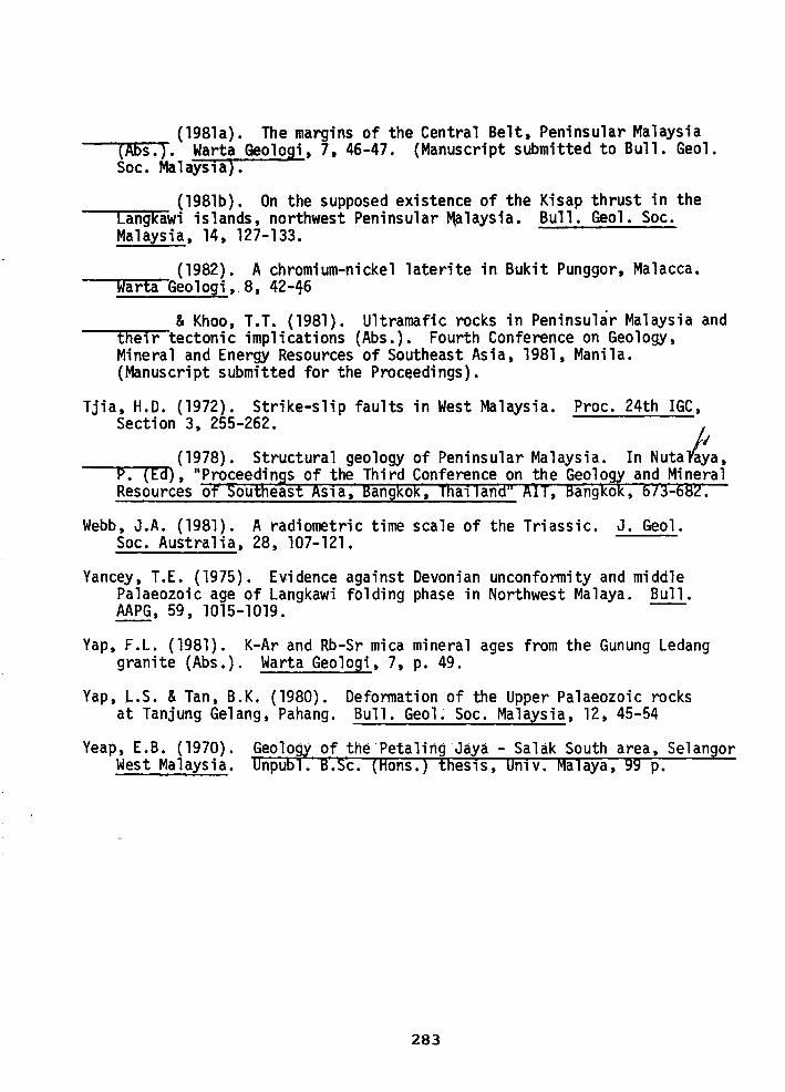
{198la). The margins of the Central Belt, Peninsular Malaysia -----r(A~b~s~.T). Warta Geologi, 7, 46-47. {Manuscript submitted to Bull. Geol.
Soc. Malaysn).
{198lb). On the supposed existence of the Kisap thrust in the -----rc~an~g~k~awi islands, northwest Peninsular ~laysia. Bull. Geol. Soc.
Malaysia, 14, 127-133.
-.......,.,~~ { 1982). A chromium-nickel laterite in Bukit Punggor, Malacca. warta Geologi,.8, 42-46
& Khoo, T.T. {1981). Ultramafic rocks in Peninsular Malaysia and --.....t .... he_,i.-r-tectonic implications {Abs.). Fourth Conference on Geology,
Mineral and Energy Resources of Southeast Asia, 1981, Manila. (Manuscript submitted for the Proceedings).
Tjia, H.D. {1972). Strike-slip faults in West Malaysia. Proc. 24th IGC, Section 3, 255-262. ·
{1978). Structural geology of Peninsular Malaysia. In Nutala~a. ----P-. ..,(.,..E~d), 11 Proceedings of the Third Conference on the Geology and Mineral
Resources of Southeast As1 a~ Bangkok, Thall and" AIT, Bangkok, 673-682.
Webb, J.A. (1981). A radiometric time scale of the Triassic. J. Geol. Soc. Australia, 28, 107-121.
Yancey, T.E. {1975). Evidence against Devonian unconformity and middle Palaeozoic age of Langkawi folding phase in Northwest Malaya. Bull. AAPG, 59, 1015-1019. --
Yap, F.L. (1981). K-Ar and Rb-Sr mica mineral ages from the Gunung Ledang granite {Abs.). Warta Geologi, 7, p. 49.
Yap, L.S. & Tan, B.K. (1980). Deformation of the Upper Palaeozoic rocks at Tanjung Gelang, Pahang. Bull. Geol. Soc. Malaysia, 12, 45-54
Yeap, E.B. (1970). West Malaysia.
283
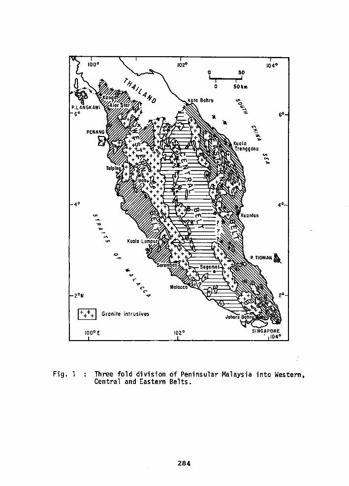
Fig. 1
102° 104° 0 50 I I I
I
0 50km
... 0 c:. ...... ~ so
... n ~
z .....
u,
"' ....
4
I++++ I Granite intrusives
Three fold division of Peninsular Malaysia into Western, Central and Eastern Belts.
284
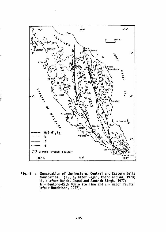
, U\ -':D
40 ,.. -U\
0 -
0 50 km
C"\
~
~ ll.
c., ,.... 1'o. 40
• ••••••• 8
0 Granitic Intrusives boundary
100° E.
Demarcation of the Western. Central and Eastern Belts boundaries. '(a1 , a2 after Rajah, Chand and Aw, 1978; d, e after Rajah, Chand and Santokh Singh, 1977; b = Bentong-Raub Ophiolite line and c = major faults after Hutchison, 1977).
285
PENINSULAR MALAYSIA
0 40 80km
I+ + +I Granite
• Serpentinised ultramafics
103° SINGAPORE 104°
Fig. 3 Serpentinite occurrences in Peninsular Malaysia defining 2 linear zones (after Tan and Khoo, 1981).
286
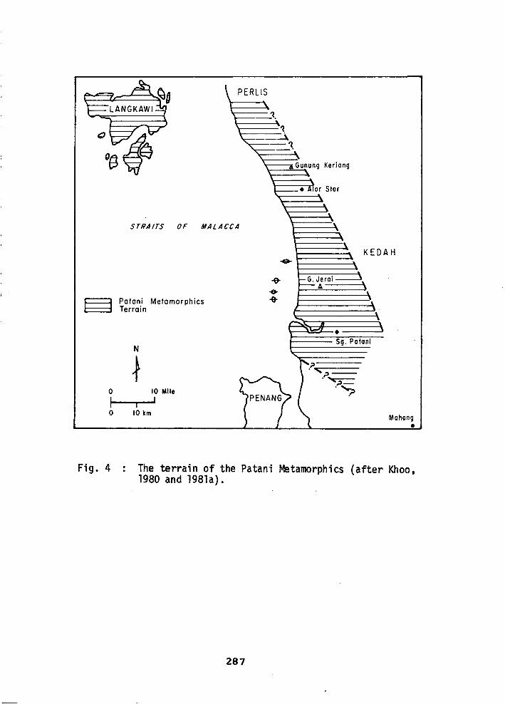
0
l 0
Fig. 4
PERL IS
STRAITS OF MALACCA
Patani Metamorphics Terrain
N
~ 10 Mile
I I
10 km
KEDAH
• Sg. Paton!
~
"'~-·~ ~-""?
Mahang •
The terrain of the Patani Metamorphics (after Khoo, 1980 and 1981a).
287
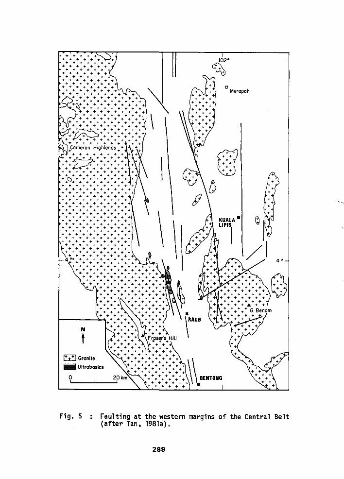
• + + + + + + + + + + +
+ + + + + + + + + + + + + +
+ + + + + + +. + + + + + + +
+ + + + + + + + + + + + + + +
+ + + + + + + + + + + + + + +
+ + + + + + + + + + + + + + + + +
+ + + + + + + + + + + + + + + + + + + +
·~· + + + + + + + + + ~· + + + + + + + +
+ + + + + + + + + + + + + + + + + + +.
+ + + + + + + + + + + + + + + + + + + + +
+ + + + + + + + + + i
~++~++++++++ + + + + + + + + + + + + + + + +
+ ~ + + + + + + + + + . + + + + + + + + + + .cameron Highlands + + + +
+ + + + + + .• + + .. +t::/1 + + + + + + + + + + + + + + + + + + +
+ + + + + + + + + + + + + + + + +
+ + + + + + + + +
·.~.·.·.·.·.·.·.·.· + + + + + + + + + +
+ + + + + + + + + + + + + + + + + + + +
+ + + + + + + + + + + + + + + + + + +
+ + + + + + + + + + + + + + + + + + + +
+ + + + + + + + + + + + + + + + + + + +
+ + + + + + + + + + + + + + + + + + + +
+ + + + + + + + + + + + + + + + + + + +
+ + + + + + + + + + + + + + + + + + + +
+ + + + + + + + + + + + + + + + + + + +
+ + + + + + + + + + + + + + + + + + +
+ + + + + + + + + + + + + + + + + + + +
4:·.·.·.·.· ..... ·.·.·. + + + + + + + + + + + +
+ + + + + + + + + + + + + + + + + + + + + + + +
+ + + + + + + + + + + + + + + + + + + + + + +
+ + + + + + + + + + + + + + + + + + + + + + +
+ + + + + + + + + + + + + + + + + + +
• + + + + + + + + + + + + + + + + + +
+ + + + + + + + + + + + + + + + +
+ + + + + + + + + + + + + + +
t-------~ ...... + + + + + + + + + + + +.
N
t E±:J Granite
~ Ultrabasics
+ .+ + + + + + + + + + + +
+ + + + + + + + Fraser's Hill +++ -~'~+
++++ ++ + + + + + + + +
+ + + + + + + + +
c Merapoh
KUALA •
LIPISI
0
+ :::::::::::::::: ·~\ + + + + + + + +
• + + + + + + + + 20 km. . + + + + + + + + + + + + BENTONG ._ ___ ..._ ___ .... + + + + + +
+.+.+.+ + +
Faulting at the western margins of the Central Belt (after Tan. 198la}.
288
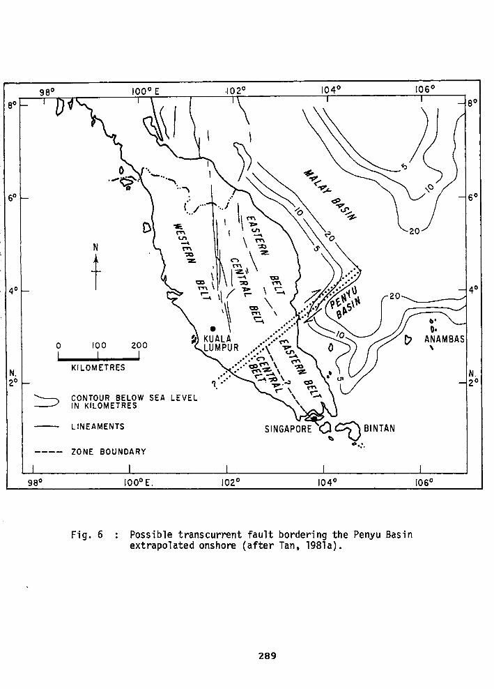
60
40
0 I
N. 20
:::::::>
98°
.. ( ... ... /
D ~
"' U"'
N ~
"'
t ':ID 'Z.
a;)
"'
100 200
I I KILOMETRES
CONTOUR BELOW SEA LEVEL IN KILOMETRES
LINEAMENTS
ZONE BOUNDARY
100° E. 102° 104°
Fig. 6 Possible transcurrent fault bordering the Penyu Basin extrapolated onshore (after Tan, 198la).
289
106°
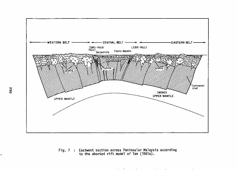
----WESTERN BELT
Fig. 7
---- --- CENTRAL BELT --• ... -------EASTERN BELT --•
LEBIR FAULT Clastic deposits
Eastwest section across Peninsular Malaysia according to the aborted rift model of Tan (198la).