Embed Size (px)
Citation preview
GEOLOGICAL AND RADIOACTIVITY STUDIES ON THE DYKES OF WADI EL AKHDAR AREA, SOUTHERN SINAI, EGYPT
ATEF H. ABD EL AZEEM
Nuclear Materials Authority, P.O. Box: 530, El Maadi, Cairo, Egypt.
ABSTRACTThe present work deals with the dykes of Wadi El Akhdar area in southern Sinai which is located
between lat. 28˚42′-28˚55′ N and long. 33˚40′-33˚53′ E and covers an area of about 700km2. The area
is characterized by basement rocks unconformably covered by Phanerozoic sedimentary rocks in the
northeastern portion. Field surveys indicated that the studied dykes traverse most rocks in Wadi El Akhdar
area except the quartz-syenite and Phanerozoic sedimentary rocks. The different rock units of the area
under consideration are traversed by various types of post-granitic dykes. Frequently, many of dykes
have curved outcrops, running in remarkable parallelism with each other and vary in inclination from
steep inclined to vertical, 0.5 to 20m in thickness and between 0.1 to 6km in length. Different types of
dykes are distinguished; acidic (granophyers, rhyolites, porphyritic rhyodacites and dacites), intermediate
(andesites) and basic (dolerites and basalts). The relative ages assigned from relationship between dykes
are given as follows: The acidic dykes were intruded first, followed eventually by two periods of a variety
of dykes. Photogeological studies of the dyke lineaments showed that the studied area is affected by the
following trends of dyke lineations; NNE, NE and NW directions. The N35˚W and N25˚E sets are the
most dominant dyke trends, while the less dominant trends are E-W, N15˚W and N56˚W. The trends ENE
and NW of dyke swarms are consistent with the main trends of dyke swarms in the Precambrian rocks
of Egypt. The regional trends of dyke swarms are strongly consistent with the regional trends of fractures
including faults and joints, i.e. dykes are structurally controlled. Radiometric measurements of dykes
indicated that, the acidic dykes are relatively more enriched in eU (av. =22.3 ppm) than other types of
dykes (av.=3.30 ppm) in intermediate dykes and (av.=2.10 ppm) in basic dykes. On the other hand, the
acidic dykes contain most eTh contents. Their average content of eTh is 25.70 ppm whereas it is 8.94 ppm
in intermediate dykes, and 4.10 ppm in basic ones. The eU contents in acidic dykes may be due to their
accessory minerals (i.e. apatite, zircon and sphene).
ISSN 2314-5609
Nuclear Sciences Scientific Journal
8, 181- 202
2019
http:// www.ssnma.com
INTRODUCTION
Wadi El Akhdar area is located between lat. 28˚42'-28˚55' N and long. 33˚40'-33˚53' E and covers an area of about 700km2. The area is a part of the Pan African crystalline base-ment in NE Africa and Arabia (Gass, 1982) and of Sinai Asiatic old Plate (El Shazly et al., 1974). It is also representing a part of arched uplift of the Late-Proterozoic-Early Paleozoic
crystalline basement of Arabia-Nubian shield, affected by tectonic and structural elements of Pan-African Orogeny (El Shazly et al., 1974).
The studied area comprises large masses of granitic rocks of Precambrian age and Pa-leozoic rocks of Cambrian age unconformably covered by sedimentary rocks of Paleozoic age. The area is drained by several wadis, intersected by fractures (faults and joints)
182 ATEF H. ABD EL AZEEM
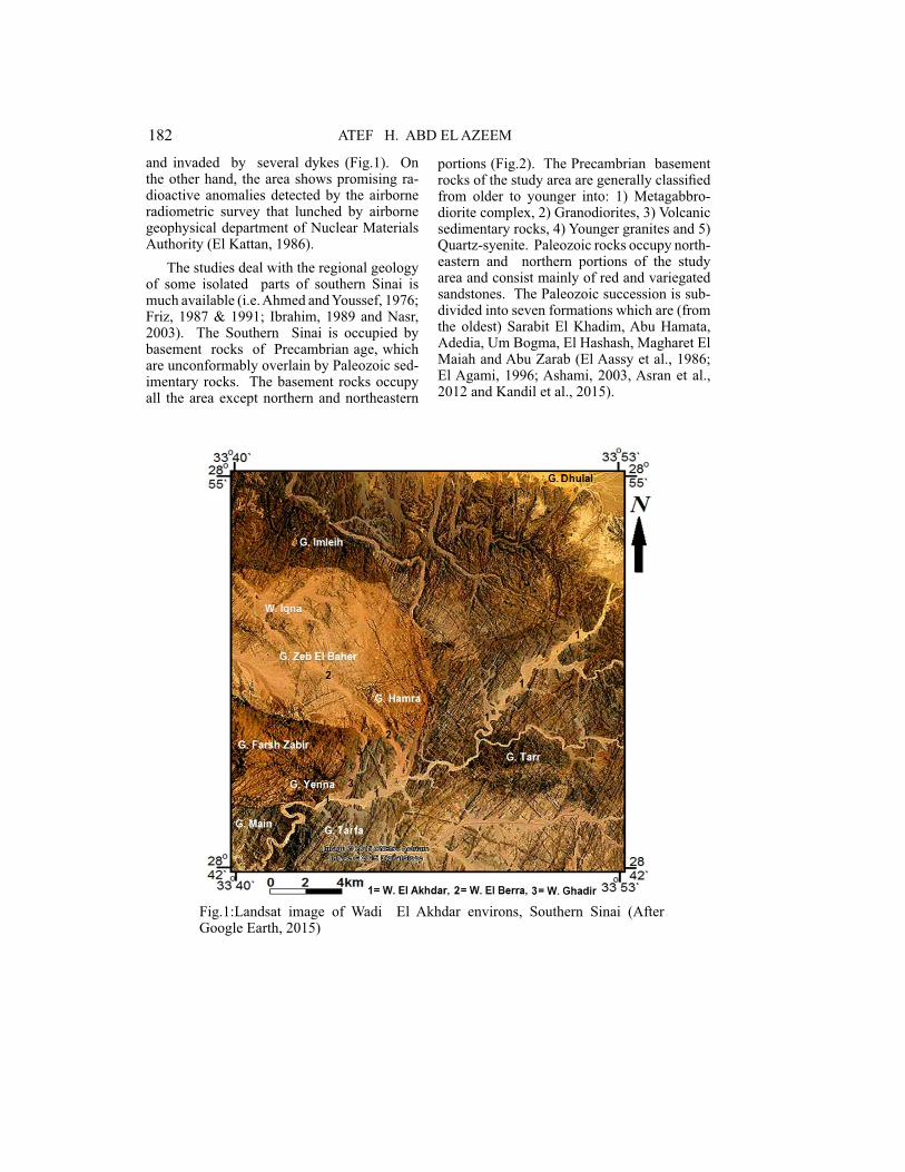
and invaded by several dykes (Fig.1). On the other hand, the area shows promising ra-dioactive anomalies detected by the airborne radiometric survey that lunched by airborne geophysical department of Nuclear Materials Authority (El Kattan, 1986).
The studies deal with the regional geology of some isolated parts of southern Sinai is much available (i.e. Ahmed and Youssef, 1976; Friz, 1987 & 1991; Ibrahim, 1989 and Nasr, 2003). The Southern Sinai is occupied by basement rocks of Precambrian age, which are unconformably overlain by Paleozoic sed-imentary rocks. The basement rocks occupy all the area except northern and northeastern
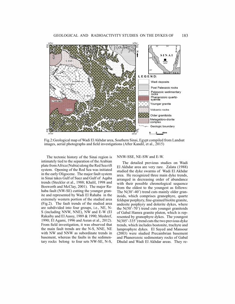
portions (Fig.2). The Precambrian basement rocks of the study area are generally classified from older to younger into: 1) Metagabbro-diorite complex, 2) Granodiorites, 3) Volcanic sedimentary rocks, 4) Younger granites and 5) Quartz-syenite. Paleozoic rocks occupy north-eastern and northern portions of the study area and consist mainly of red and variegated sandstones. The Paleozoic succession is sub-divided into seven formations which are (from the oldest) Sarabit El Khadim, Abu Hamata, Adedia, Um Bogma, El Hashash, Magharet El Maiah and Abu Zarab (El Aassy et al., 1986; El Agami, 1996; Ashami, 2003, Asran et al., 2012 and Kandil et al., 2015).
�
Fig.1:Landsat image of Wadi El Akhdar environs, Southern Sinai (After Google Earth, 2015)
183GEOLOGICAL AND RADIOACTIVITY STUDIES ON THE DYKES OF
The tectonic history of the Sinai region is intimately tied to the separation of the Arabian plate from Africa (Nubia) along the Red Sea rift system. Opening of the Red Sea was initiated in the early Oligocene. The major fault system in Sinai takes Gulf of Suez and Gulf of Aqaba trends (Steckler et al., 1988; Khalil, 1998 and Bosworth and McClay, 2001). The major Ra-haba fault (NW-SE) cutting the younger gran-ite and represented by Wadi El Rahaba in the extremely western portion of the studied area (Fig.2). The fault trends of the studied area are subdivided into four groups, i.e., NE, N-S (including NNW, NNE), NW and E-W (El Rakaiby and El Aassy, 1989 & 1990; Meshref, 1990; El Agami, 1996 and Asran et al., 2012). From field investigation, it was observed that the main fault trends are the N-S, NNE, NE with NW and NNW as subordinate trends in basement, whereas the faults in the sedimen-tary rocks belong to four sets NW-SE, N-S,
�
Fig.2:Geological map of Wadi El Akhdar area, Southern Sinai, Egypt compiled from Landsat images, aerial photographs and field investigations (After Kandil, et al., 2015)
NNW-SSE, NE-SW and E-W.
The detailed previous studies on Wadi El Akhdar area are very rare. Zalata (1988) studied the dyke swarms of Wadi El Akhdar area. He recognized three main dyke trends, arranged in decreasing order of abundance with their possible chronological sequence from the oldest to the youngest as follows: The N(30˚-40˚) trend cuts mainly older gran-itoids, which comprises granophyre, quartz feldspar porphyry, fine-grained biotite granite, andesite porphyry and dolerite dykes, where the N(50˚-70˚) trend cuts younger granitoids of Gabal Hamra granite pluton, which is rep-resented by granophyre dykes. The youngest N(305˚-335˚) trend cuts the two previous dyke trends, which includes bostonite, trachyte and lamprophyre dykes. El Sayed and Mansour (2003) were studied Precambrian basement and Phanerozoic sedimentary rocks of Gabal Dhulal and Wadi El Akhdar areas. They re-
184 ATEF H. ABD EL AZEEM
corded a high radioactivity in the basal con-glomerate of the sedimentary succession due to presence of xenotime and Fe-oxides, while they attributed radioactivity in the younger granites to presence of hematite. Kandil et al. (2015) studied the photo lineament in Wadi El Akhdar area revealed that the length and num-ber of lineaments arranged in two major trends namely NW-SE and NNE-SSW. They also detected lithologically and structurally con-trolled radiometric anomalies in Wadi El Akh-dar environ. Sadek and Abbas (2017) studied the geology, geochemistry and radioactivity of the dyke swarms at Wadi El Akhdar area. They concluded that the area dissected by two main dyke trends cutting mainly the older granites. The oldest are basaltic and trend-ing (NE-SW), intermediate (NW-SE) cut the former dyke trend. The major dykes trending NE-SW are acidic representing the terminate emplacement of the studied dyke.
The present study deals with the geology and radioactivity of the dyke swarms in Wadi El Akhdar area, and their controlling fac-tors. Detailed photo lineaments, mineralogic and spectrometric studies have been done to achieve this target.
METHODOLOGY
Field Work Studies
Fifteen representative samples were col-lected from the studied dykes. These samples include; five from the acidic dykes, five from the intermediate dykes and five from the basic dykes with about 25kg for each one. More-over, about 40 field photographs were taken showing field relations and observations for the different dykes. Furthermore, the spec-trometry (in cps) was measured for different dykes in the field by using a portable gamma ray scintlliometer model GR 101A.
Petrographical Studies
Thirty-five thin sections had been pre-pared and represent the selected samples for the different dykes of the study area. The pet-
rographical and mineralogical studies were carried out on these thin sections using the polarizing microscope. More than 150 mi-crophotographs were taken to show the pe-trographic features, their textures and specific inter relations between minerals.
Photogeological Studies
This work depends mainly on aerial photo-graphs of scale 1:40.000 and photomosaics of scale 1:50.000 with topographic maps of scale 1:50.000.
Radiometric Investigations
Fifteen samples representing the investi-gated dykes were collected for spectrometric laboratory studies to determine their equiva-lent U (eU) and equivalent (eTh) Th in ppm and K%. Gamma Spectrometric technique uses the multi channel analyzer of X-ray de-tector of a Bicron Scintillation Detector Nal (TL) 76 x 76mm. This method was used for the determination of eU and eTh concentra-tions in the different samples by measure-ments of the decay products of Th234 and Pb212 as follows: The rock sample was crushed to about 100 mish particle size and put in a cylin-drical plastic container 9.5cm in diameter, and 3cm height. The containers are well sealed and left for at least 28 days to accumulate free radon and attain radioactive equilibrium. The standards are measured two times, 100 sec-onds for each. The average of the total count for each sample is taken and divided by its net weigh and introduced in computer program to calculate eU, eTh in ppm, and K%.
RESULTS AND DISCUSSION
Field Work Studies
Dykes traverse most basement rocks in Wadi El Akhdar area except the Phanerozoic quartz-syenite. They vary greatly in both thickness from centimeters up to 20 m and in composition from acidic to basic. The rela-tive ages assigned from relationship between dykes are given as follows: the acidic dykes
185GEOLOGICAL AND RADIOACTIVITY STUDIES ON THE DYKES OF
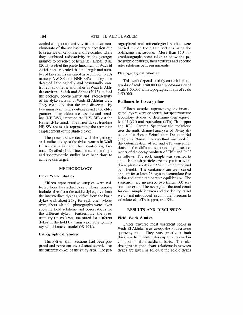
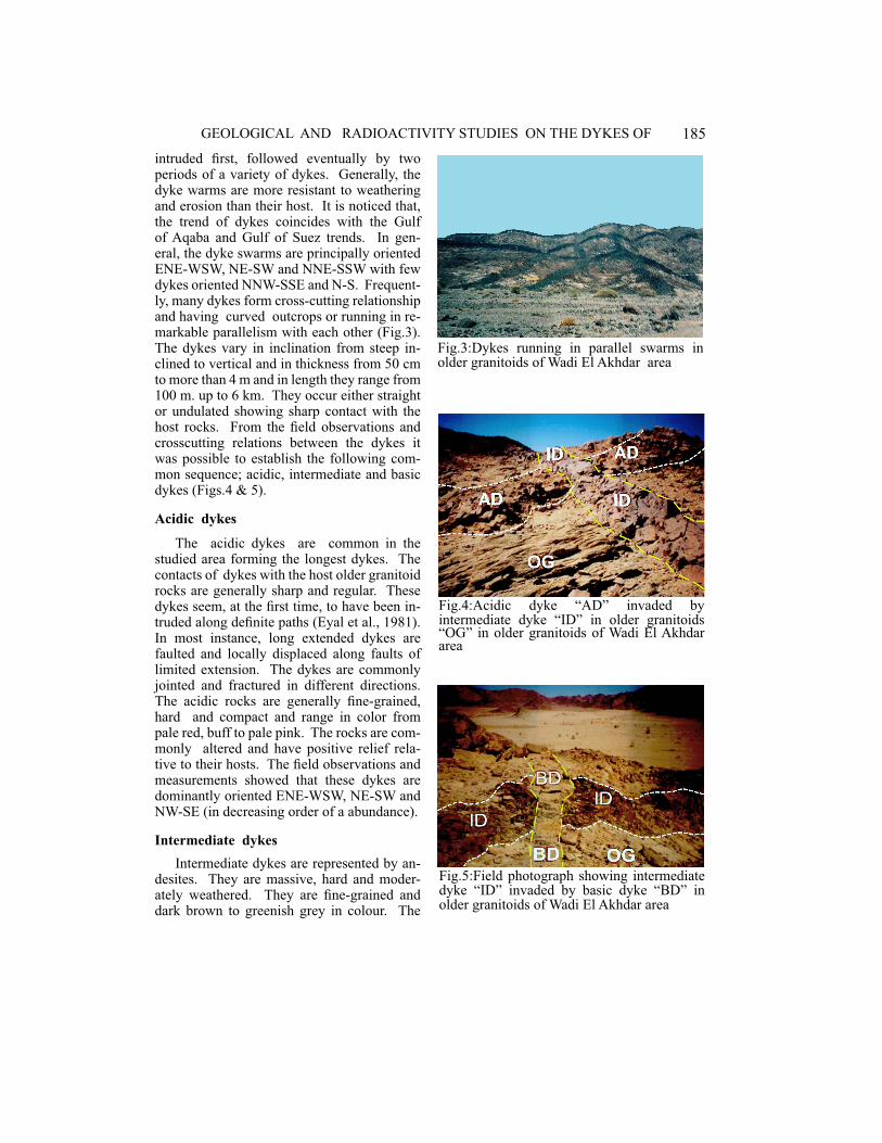
intruded first, followed eventually by two periods of a variety of dykes. Generally, the dyke warms are more resistant to weathering and erosion than their host. It is noticed that, the trend of dykes coincides with the Gulf of Aqaba and Gulf of Suez trends. In gen-eral, the dyke swarms are principally oriented ENE-WSW, NE-SW and NNE-SSW with few dykes oriented NNW-SSE and N-S. Frequent-ly, many dykes form cross-cutting relationship and having curved outcrops or running in re-markable parallelism with each other (Fig.3). The dykes vary in inclination from steep in-clined to vertical and in thickness from 50 cm to more than 4 m and in length they range from 100 m. up to 6 km. They occur either straight or undulated showing sharp contact with the host rocks. From the field observations and crosscutting relations between the dykes it was possible to establish the following com-mon sequence; acidic, intermediate and basic dykes (Figs.4 & 5).
Acidic dykes
The acidic dykes are common in the studied area forming the longest dykes. The contacts of dykes with the host older granitoid rocks are generally sharp and regular. These dykes seem, at the first time, to have been in-truded along definite paths (Eyal et al., 1981). In most instance, long extended dykes are faulted and locally displaced along faults of limited extension. The dykes are commonly jointed and fractured in different directions. The acidic rocks are generally fine-grained, hard and compact and range in color from pale red, buff to pale pink. The rocks are com-monly altered and have positive relief rela-tive to their hosts. The field observations and measurements showed that these dykes are dominantly oriented ENE-WSW, NE-SW and NW-SE (in decreasing order of a abundance).
Intermediate dykes
Intermediate dykes are represented by an-desites. They are massive, hard and moder-ately weathered. They are fine-grained and dark brown to greenish grey in colour. The
�
Fig.3:Dykes running in parallel swarms in older granitoids of Wadi El Akhdar area
�
Fig.4:Acidic dyke “AD” invaded by intermediate dyke “ID” in older granitoids “OG” in older granitoids of Wadi El Akhdar area
�
Fig.5:Field photograph showing intermediate dyke “ID” invaded by basic dyke “BD” in older granitoids of Wadi El Akhdar area
186 ATEF H. ABD EL AZEEM
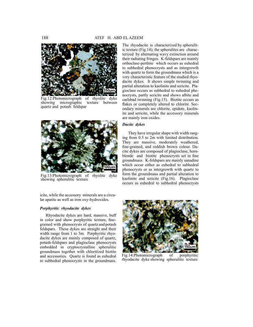
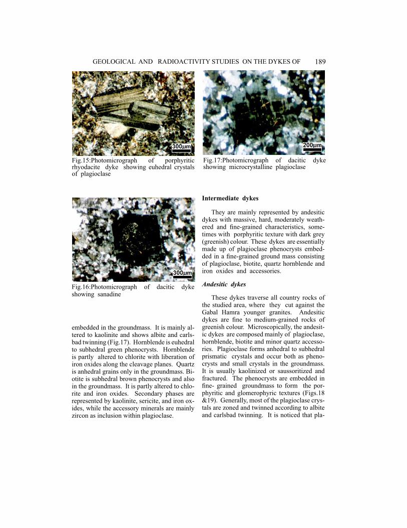
mainly represented by orthoclase which oc-curs in euhedral to subhedral crystals slightly altered to kaolinite and sericite (Fig.8). Pla-gioclase forms subhedral crystals (Fig.9), usually kaolinized and occurring as pheno-crysts in groundmass. Biotite is rare and oc-curs as euhedral to subhedral, fine-grained flakes with brown colour, slightly altered to chlorite and iron oxides (Fig.10). Ground-mass mainly consists of fine-grained quartz, which occurs either as free grains or inter grown with feldspars producing granophyric
field observations and measurements showed that these dykes are dominantly oriented at NNE-SSW trend.
Basic dykes
Basic dykes are massive, hard and fine-grained with greenish grey colour and are represented mainly by two varieties; basalt and porphyritic dolerite. Few basic dykes are recorded and some of these dykes are more susceptible to erosion than the host granitoids giving rise to deep grooves. The weathered porphyritic dolerite dykes are usually fash-ioned into distinctive onion-like boulders. Their widths range from 60 cm to 4 m and have been intruded along certain fracture trends (ENE-WSW, NE-SW, and NW-SE). They invaded the volcanic rocks (NE-SW trend) and granites plutones at ENE-WSW and NW-SE trends.
Petrographical Studies of the Dykes
Acidic dykes
They are more common dykes in the stud-ied area and distributed mainly in/and around the younger granites. Few of them are en-countered in the older granitoids. The acidic dykes are generally fine-grained and pale red, buff to pink in colours. They are subjected to variable degrees of alteration as exhibited by the alteration of feldspars. These dykes are represented by granophyre, rhyolite, rhyoda-cite and dacite dykes.
Granophyre dykes
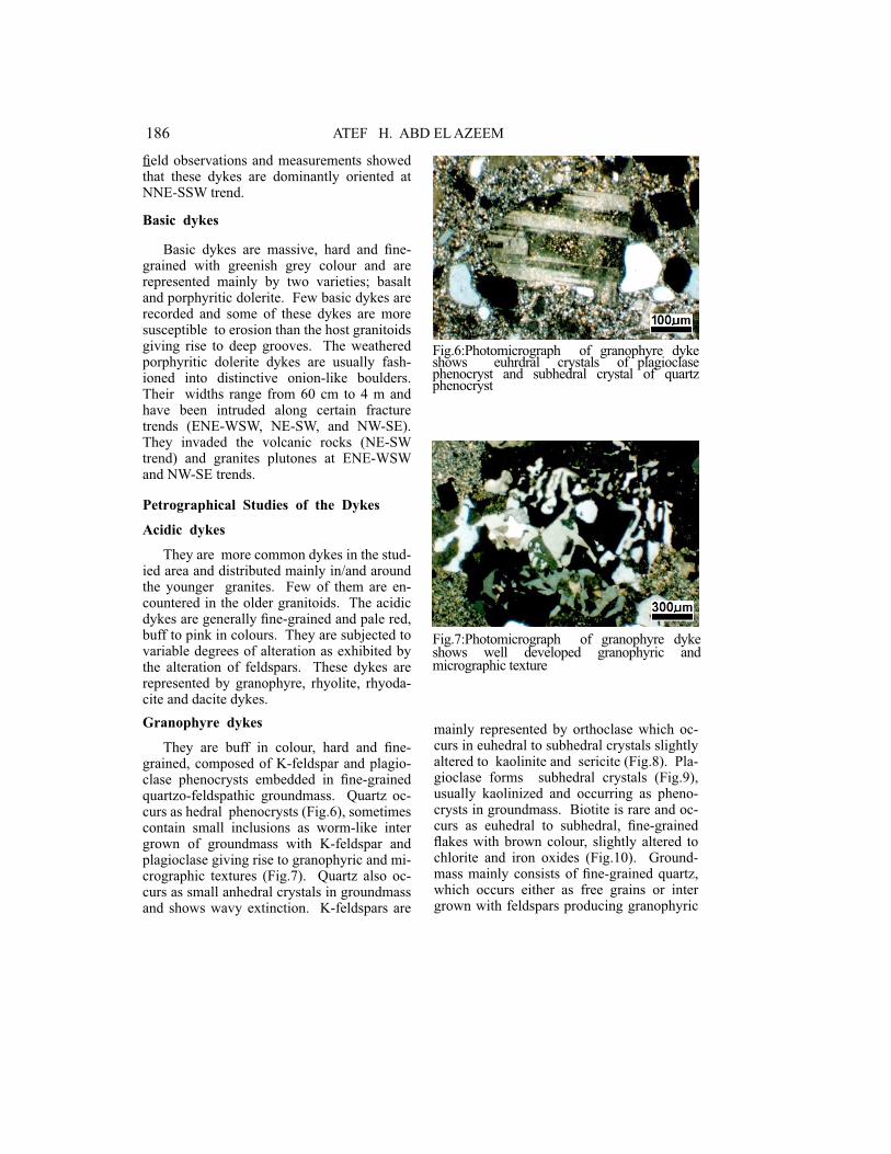
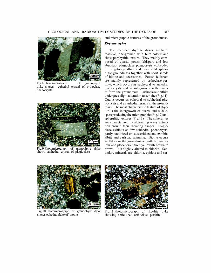
They are buff in colour, hard and fine-grained, composed of K-feldspar and plagio-clase phenocrysts embedded in fine-grained quartzo-feldspathic groundmass. Quartz oc-curs as hedral phenocrysts (Fig.6), sometimes contain small inclusions as worm-like inter grown of groundmass with K-feldspar and plagioclase giving rise to granophyric and mi-crographic textures (Fig.7). Quartz also oc-curs as small anhedral crystals in groundmass and shows wavy extinction. K-feldspars are
�
Fig.6:Photomicrograph of granophyre dyke shows euhrdral crystals of plagioclase phenocryst and subhedral crystal of quartz phenocryst
�
Fig.7:Photomicrograph of granophyre dyke shows well developed granophyric and micrographic texture
187GEOLOGICAL AND RADIOACTIVITY STUDIES ON THE DYKES OF
�
Fig.8:Photomicrograph of granophyre dyke shows euhedral crystal of orthoclase phenocrysts
�
Fig.9:Photomicrograph of granophyre dyke shows subhedral crystal of plagioclase
�
Fig.10:Photomicrograph of granophyre dyke shows euhedral flake of biotite
and micrographic textures of the groundmass.
Rhyolite dykes
The recorded rhyolite dykes are hard, massive, fine-grained with buff colour and show porphyritic texture. They mainly com-posed of quartz, potash-feldspars and less abundant plagioclase phenocrysts embedded in cryptocrystalline and devitrified spheri-olitic groundmass together with short shreds of biotite and accessories. Potash feldspars are mainly represented by orthoclase-per-thite, which occurs as subhedral to anhedral phenocrysts and as intergrowth with quartz to form the groundmass. Orthoclase-perthite undergoes slight alteration to sericite (Fig.11). Quartz occurs as euhedral to subhedral phe-nocrysts and as anhedral grains in the ground-mass. The most characteristic feature of rhyo-lite is the intergrowth of quartz and K-feld-spars producing the micrographic (Fig.12) and spherulitic textures (Fig.13). The spherulites are characterized by alternating wavy extinc-tion around their radiating fringes. Plagio-clase exhibits as few subhedral phenocrysts, partly kaolinized or saussoritized and exhibits albite and carlsbad twinning. Biotite occurs as flakes in the groundmass with brown co-lour and pleochoric from yellowish brown to brown. It is slightly altered to chlorite. Sec-ondary minerals are chlorite, epidote and ser-
�
Fig.11:Photomicrograph of rhyolite dyke showing sericitized orthoclase perthite
188 ATEF H. ABD EL AZEEM
�
Fig.12:Photomicrograph of rhyolite dyke showing micrographic texture between quartz and potash feldspar
�
Fig.13:Photomicrograph of rhyolite dyke showing spherulitic texture
�
Fig.14:Photomicrograph of porphyritic rhyodacite dyke showing spherulitic texture
The rhyodacite is characterized by spherulit-ic texture (Fig.14); the spherulites are charac-terized by alternating wavy extinction around their radiating fringes. K-feldspars are mainly orthoclase-perthite which occurs as euhedral to subhedral phenocrysts and as intergrowth with quartz to form the groundmass which is a very characteristic feature of the studied rhyo-dacite dykes. It shows simple twinning and partial alteration to kaolinite and sericite. Pla-gioclase occurs as subhedral to euhedral phe-nocrysts, partly sericite and shows albite and carlsbad twinning (Fig.15). Biotite occurs as flakes or completely altered to chlorite. Sec-ondary minerals are chlorite, epidote, kaolin-ite and sericite, while the accessory minerals are mainly iron oxides.
Dacite dykes
They have irregular shape with width rang-ing from 0.5 to 2m with limited distribution. They are massive, moderately weathered, fine-grained, and reddish brown colour. Da-cite dykes are composed of plagioclase, horn-blende and biotite phenocrysts set in fine groundmass. K-feldspars are mainly sanadine which occur either as euhedral to subhedral phenocrysts or as intergrowth with quartz to form the groundmass and partial alteration to kaolinite and sericite (Fig.16). Plagioclase occurs as euhedral to subhedral phenocrysts
icite, while the accessory minerals are a circu-lar apatite as well as iron oxy-hydroxides.
Porphyritic rhyodacite dykes
Rhyodacite dykes are hard, massive, buff in color and show porphyritic texture, fine-grained with phenocrysts of quartz and potash feldspars. These dykes are straight and their width range from 1 to 3m. Porphyritic rhyo-dacite dykes are mainly composed of quartz, potash-feldspars and plagioclase phenocrysts embedded in cryptocrystalline spherulitic groundmass together with chloritized biotite and accessories. Quartz is found as euhedral to subhedral phenocrysts in the groundmass.
189GEOLOGICAL AND RADIOACTIVITY STUDIES ON THE DYKES OF
�
Fig.15:Photomicrograph of porphyritic rhyodacite dyke showing euhedral crystals of plagioclase
�
Fig.16:Photomicrograph of dacitic dyke showing sanadine
�
Fig.17:Photomicrograph of dacitic dyke showing microcrystalline plagioclase
embedded in the groundmass. It is mainly al-tered to kaolinite and shows albite and carls-bad twinning (Fig.17). Hornblende is euhedral to subhedral green phenocrysts. Hornblende is partly altered to chlorite with liberation of iron oxides along the cleavage planes. Quartz is anhedral grains only in the groundmass. Bi-otite is subhedral brown phenocrysts and also in the groundmass. It is partly altered to chlo-rite and iron oxides. Secondary phases are represented by kaolinite, sericite, and iron ox-ides, while the accessory minerals are mainly zircon as inclusion within plagioclase.
Intermediate dykes
They are mainly represented by andesitic dykes with massive, hard, moderately weath-ered and fine-grained characteristics, some-times with porphyritic texture with dark grey (greenish) colour. These dykes are essentially made up of plagioclase phenocrysts embed-ded in a fine-grained ground mass consisting of plagioclase, biotite, quartz hornblende and iron oxides and accessories.
Andesitic dykes
These dykes traverse all country rocks of the studied area, where they cut against the Gabal Hamra younger granites. Andesitic dykes are fine to medium-grained rocks of greenish colour. Microscopically, the andesit-ic dykes are composed mainly of plagioclase, hornblende, biotite and minor quartz accesso-ries. Plagioclase forms anhedral to subhedral prismatic crystals and occur both as pheno-crysts and small crystals in the groundmass. It is usually kaolinized or saussoritized and fractured. The phenocrysts are embedded in fine- grained groundmass to form the por-phyritic and glomerophyric textures (Figs.18 &19). Generally, most of the plagioclase crys-tals are zoned and twinned according to albite and carlsbad twinning. It is noticed that pla-
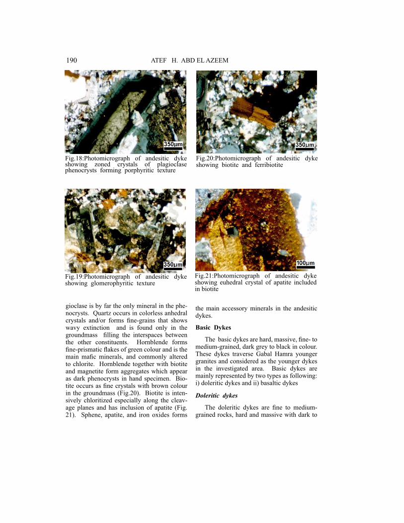
190 ATEF H. ABD EL AZEEM
�
Fig.18:Photomicrograph of andesitic dyke showing zoned crystals of plagioclase phenocrysts forming porphyritic texture
�
Fig.19:Photomicrograph of andesitic dyke showing glomerophyritic texture
�
Fig.20:Photomicrograph of andesitic dyke showing biotite and ferribiotite
�
Fig.21:Photomicrograph of andesitic dyke showing euhedral crystal of apatite included in biotite
gioclase is by far the only mineral in the phe-nocrysts. Quartz occurs in colorless anhedral crystals and/or forms fine-grains that shows wavy extinction and is found only in the groundmass filling the interspaces between the other constituents. Hornblende forms fine-prismatic flakes of green colour and is the main mafic minerals, and commonly altered to chlorite. Hornblende together with biotite and magnetite form aggregates which appear as dark phenocrysts in hand specimen. Bio-tite occurs as fine crystals with brown colour in the groundmass (Fig.20). Biotite is inten-sively chloritized especially along the cleav-age planes and has inclusion of apatite (Fig. 21). Sphene, apatite, and iron oxides forms
the main accessory minerals in the andesitic dykes.
Basic Dykes
The basic dykes are hard, massive, fine- to medium-grained, dark grey to black in colour. These dykes traverse Gabal Hamra younger granites and considered as the younger dykes in the investigated area. Basic dykes are mainly represented by two types as following: i) doleritic dykes and ii) basaltic dykes
Doleritic dykes
The doleritic dykes are fine to medium-grained rocks, hard and massive with dark to
191GEOLOGICAL AND RADIOACTIVITY STUDIES ON THE DYKES OF
�
Fig.22:Photomicrograph of doloritic dyke showing crystal of plagioclase exhibits periclinic twinning
�
Fig.23:Photomicrograph of doloritic dyke showing doloritic (diabasic) texture
�
Fig.24:Photomicrograph of doloritic dyke showing simple twinning of hornblende
greenish grey colour with porphyritic texture. Microscopically, the doleritic dykes are essen-tially made up of plagioclase, pyroxene and hornblende, with accessories of iron oxides. Plagioclase forms large euhedral to subhedral tabular crystals as well as fine laths constitut-ing the groundmass. Sometimes, plagioclase is partly altered to saussorite and kaolinite, and twinned according to albite, carlsbad, periclinic laws (Fig.22). Plagioclase laths are, sometimes, intersecting in one of their ends to form the diabase texture (Fig.23). Pyroxene is mainly represented by augite. Augite occurs as subhedral prismatic or fibrous crystals en-closing partly or completely plagioclase lath to form subophitic or ophitic textures. Horn-blende forms large rhombic crystals with clear two sets of cleavage, as well as fine-prismatic crystals in the groundmass (Fig.24). Horn-blende has brown or brownish green color and is pleochoric with X=pale green, Y=brown and Z=dark brown. Hornblende is commonly altered to chlorite and sometimes perforated by quartz and iron oxide grains. Biotite is detected in few small flakes associated with hornblende. It is commonly altered to iron ox-ide and chlorite. Secondary minerals are chlo-rite and sericite, while apatite, and iron oxides represent the accessory minerals.
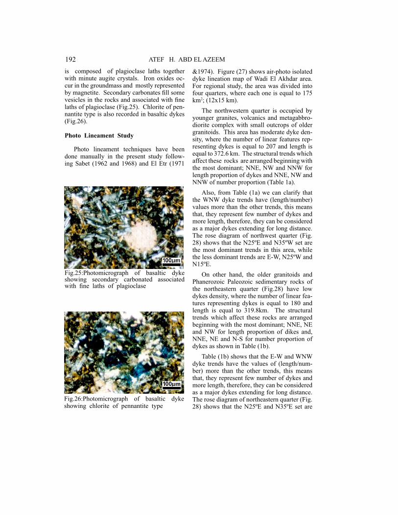
Basaltic dykes
The basaltic dykes are hard, massive, fine-grained with black colour. Microscopically, the basaltic dykes are essentially composed of plagioclase, augite, and hornblende phe-nocrysts set in a fine-grained groundmass. Plagioclase occurs as subhedral phenocrysts which are partly enclosed in augite to form subophitic textures. It shows albite, and com-bined albite and carlsbad twinning. It is no-ticed that some plagioclase crystals cross each other indicating the presence of more than one generation. Hornblende forms subhedral phenocrysts as well as in the groundmass. Hornblende has brown or brownish green color and is pleochoric with X=pale green, Y = brown and Z=dark brown. The groundmass
192 ATEF H. ABD EL AZEEM
�
Fig.25:Photomicrograph of basaltic dyke showing secondary carbonated associated with fine laths of plagioclase
�
Fig.26:Photomicrograph of basaltic dyke showing chlorite of pennantite type
is composed of plagioclase laths together with minute augite crystals. Iron oxides oc-cur in the groundmass and mostly represented by magnetite. Secondary carbonates fill some vesicles in the rocks and associated with fine laths of plagioclase (Fig.25). Chlorite of pen-nantite type is also recorded in basaltic dykes (Fig.26).
Photo Lineament Study
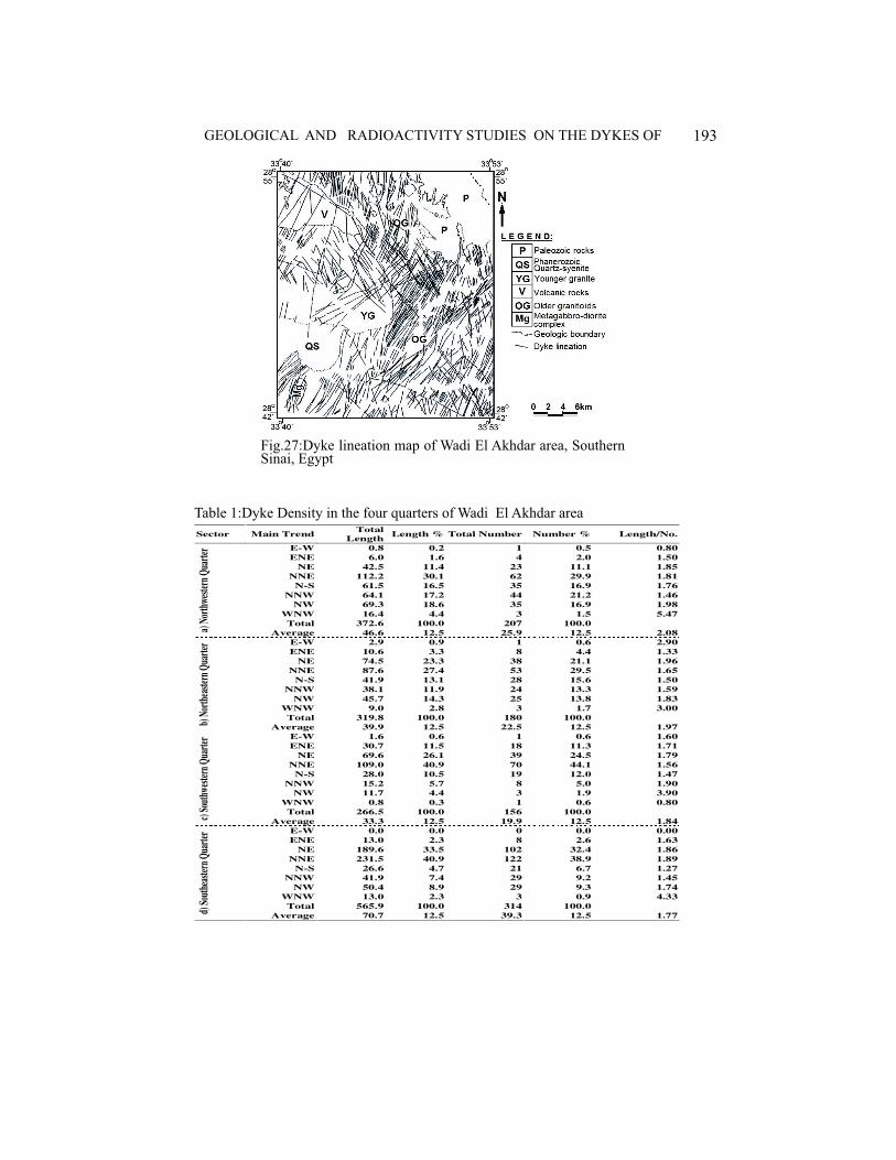
Photo lineament techniques have been done manually in the present study follow-ing Sabet (1962 and 1968) and El Etr (1971
&1974). Figure (27) shows air-photo isolated dyke lineation map of Wadi El Akhdar area. For regional study, the area was divided into four quarters, where each one is equal to 175 km2; (12x15 km).
The northwestern quarter is occupied by younger granites, volcanics and metagabbro-diorite complex with small outcrops of older granitoids. This area has moderate dyke den-sity, where the number of linear features rep-resenting dykes is equal to 207 and length is equal to 372.6 km. The structural trends which affect these rocks are arranged beginning with the most dominant; NNE, NW and NNW for length proportion of dykes and NNE, NW and NNW of number proportion (Table 1a).
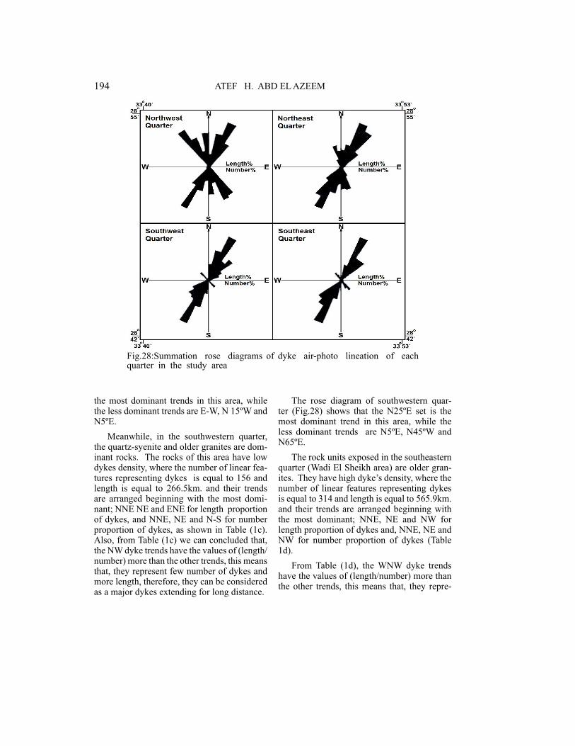
Also, from Table (1a) we can clarify that the WNW dyke trends have (length/number) values more than the other trends, this means that, they represent few number of dykes and more length, therefore, they can be considered as a major dykes extending for long distance. The rose diagram of northwest quarter (Fig. 28) shows that the N25ºE and N35ºW set are the most dominant trends in this area, while the less dominant trends are E-W, N25ºW and N15ºE.
On other hand, the older granitoids and Phanerozoic Paleozoic sedimentary rocks of the northeastern quarter (Fig.28) have low dykes density, where the number of linear fea-tures representing dykes is equal to 180 and length is equal to 319.8km. The structural trends which affect these rocks are arranged beginning with the most dominant; NNE, NE and NW for length proportion of dikes and, NNE, NE and N-S for number proportion of dykes as shown in Table (1b).
Table (1b) shows that the E-W and WNW dyke trends have the values of (length/num-ber) more than the other trends, this means that, they represent few number of dykes and more length, therefore, they can be considered as a major dykes extending for long distance. The rose diagram of northeastern quarter (Fig. 28) shows that the N25ºE and N35ºE set are
193GEOLOGICAL AND RADIOACTIVITY STUDIES ON THE DYKES OF
Sector Main TrendTotal
LengthLength % Total Number Number % Length/No.
a) N
orth
wes
tern
Qua
rter
E-W 0.8 0.2 1 0.5 0.80
ENE 6.0 1.6 4 2.0 1.50
NE 42.5 11.4 23 11.1 1.85
NNE 112.2 30.1 62 29.9 1.81
N-S 61.5 16.5 35 16.9 1.76
NNW 64.1 17.2 44 21.2 1.46
NW 69.3 18.6 35 16.9 1.98
WNW 16.4 4.4 3 1.5 5.47
Total 372.6 100.0 207 100.0
Average 46.6 12.5 25.9 12.5 2.08
b) N
orth
east
ern
Qua
rter
E-W 2.9 0.9 1 0.6 2.90
ENE 10.6 3.3 8 4.4 1.33
NE 74.5 23.3 38 21.1 1.96
NNE 87.6 27.4 53 29.5 1.65
N-S 41.9 13.1 28 15.6 1.50
NNW 38.1 11.9 24 13.3 1.59
NW 45.7 14.3 25 13.8 1.83
WNW 9.0 2.8 3 1.7 3.00
Total 319.8 100.0 180 100.0
Average 39.9 12.5 22.5 12.5 1.97
c) S
outh
wes
tern
Qua
rter
E-W 1.6 0.6 1 0.6 1.60
ENE 30.7 11.5 18 11.3 1.71
NE 69.6 26.1 39 24.5 1.79
NNE 109.0 40.9 70 44.1 1.56
N-S 28.0 10.5 19 12.0 1.47
NNW 15.2 5.7 8 5.0 1.90
NW 11.7 4.4 3 1.9 3.90
WNW 0.8 0.3 1 0.6 0.80
Total 266.5 100.0 156 100.0
Average 33.3 12.5 19.9 12.5 1.84
d) S
outh
east
ern
Qua
rter
E-W 0.0 0.0 0 0.0 0.00
ENE 13.0 2.3 8 2.6 1.63
NE 189.6 33.5 102 32.4 1.86
NNE 231.5 40.9 122 38.9 1.89
N-S 26.6 4.7 21 6.7 1.27
NNW 41.9 7.4 29 9.2 1.45
NW 50.4 8.9 29 9.3 1.74
WNW 13.0 2.3 3 0.9 4.33
Total 565.9 100.0 314 100.0
Average 70.7 12.5 39.3 12.5 1.77
�
Table 1:Dyke Density in the four quarters of Wadi El Akhdar area
�
Fig.27:Dyke lineation map of Wadi El Akhdar area, Southern Sinai, Egypt
194 ATEF H. ABD EL AZEEM
�
Fig.28:Summation rose diagrams of dyke air-photo lineation of each quarter in the study area
the most dominant trends in this area, while the less dominant trends are E-W, N 15ºW and N5ºE.
Meanwhile, in the southwestern quarter, the quartz-syenite and older granites are dom-inant rocks. The rocks of this area have low dykes density, where the number of linear fea-tures representing dykes is equal to 156 and length is equal to 266.5km. and their trends are arranged beginning with the most domi-nant; NNE NE and ENE for length proportion of dykes, and NNE, NE and N-S for number proportion of dykes, as shown in Table (1c). Also, from Table (1c) we can concluded that, the NW dyke trends have the values of (length/number) more than the other trends, this means that, they represent few number of dykes and more length, therefore, they can be considered as a major dykes extending for long distance.
The rose diagram of southwestern quar-ter (Fig.28) shows that the N25ºE set is the most dominant trend in this area, while the less dominant trends are N5ºE, N45ºW and N65ºE.
The rock units exposed in the southeastern quarter (Wadi El Sheikh area) are older gran-ites. They have high dyke’s density, where the number of linear features representing dykes is equal to 314 and length is equal to 565.9km. and their trends are arranged beginning with the most dominant; NNE, NE and NW for length proportion of dykes and, NNE, NE and NW for number proportion of dykes (Table 1d).
From Table (1d), the WNW dyke trends have the values of (length/number) more than the other trends, this means that, they repre-
195GEOLOGICAL AND RADIOACTIVITY STUDIES ON THE DYKES OF
Main Trend Total Length (km) Length % Total Number Number % Length/ Number
E-W 5.3 0.4 3 0.2 1.77
ENE 60.0 4.0 38 4.3 1.58
NE 345.1 23.1 212 24.4 1.62
NNE 540.1 36.1 307 35.4 1.76
N-S 158.7 10.6 103 11.9 1.54
NNW 159.4 10.7 105 12.1 1.52
NW 186.5 12.5 92 10.6 2.03
WNW 39.7 2.6 9 1.1 4.41
Total 1494.7 100.0 869 100.0
Average 186.9 12.5 108.6 12.5 2.03
�
Table 2:Dykes density at each 22.5º at Wadi El Akhdar area
�
Fig.29:Rose diagram and frequency distribution curves for number and length of dyke lineation in Wadi El Akhdar area, Southern Sinai, Egypt
sent few number of dykes and more length, therefore, they can be considered as a major dykes extending for long distance.
The rose diagram of the southeastern quarter (Fig.28) shows that the N25ºE set is the most dominant trend in this area. The less dominant trends are N15ºE, N35ºW and N25ºW.
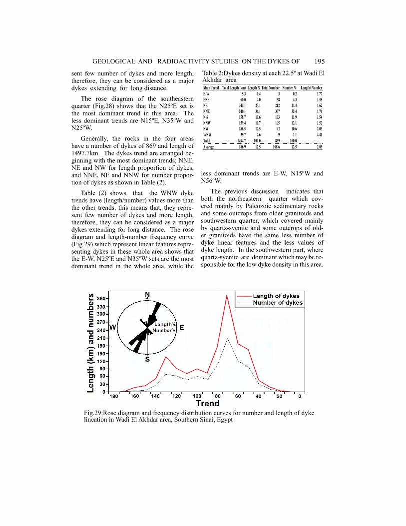
Generally, the rocks in the four areas have a number of dykes of 869 and length of 1497.7km. The dykes trend are arranged be-ginning with the most dominant trends; NNE, NE and NW for length proportion of dykes, and NNE, NE and NNW for number propor-tion of dykes as shown in Table (2).
Table (2) shows that the WNW dyke trends have (length/number) values more than the other trends, this means that, they repre-sent few number of dykes and more length, therefore, they can be considered as a major dykes extending for long distance. The rose diagram and length-number frequency curve (Fig.29) which represent linear features repre-senting dykes in these whole area shows that the E-W, N25ºE and N35ºW sets are the most dominant trend in the whole area, while the
less dominant trends are E-W, N15ºW and N56ºW.
The previous discussion indicates that both the northeastern quarter which cov-ered mainly by Paleozoic sedimentary rocks and some outcrops from older granitoids and southwestern quarter, which covered mainly by quartz-syenite and some outcrops of old-er granitoids have the same less number of dyke linear features and the less values of dyke length. In the southwestern part, where quartz-syenite are dominant which may be re-sponsible for the low dyke density in this area.
196 ATEF H. ABD EL AZEEM
�
Fig.30:Density maps for number of dykes in Wadi El Akhdar area, Southern Sinai, Egypt, Unit = 40 dyke/km2
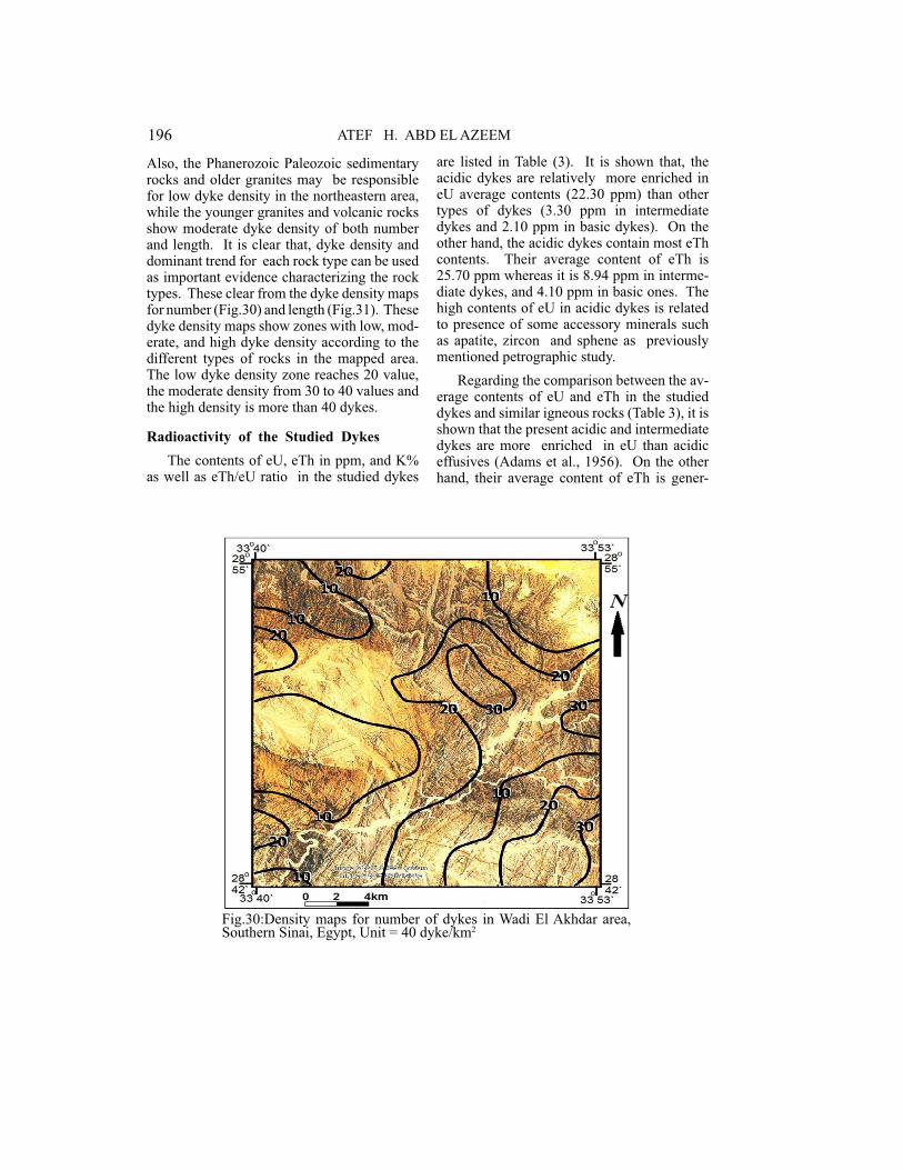
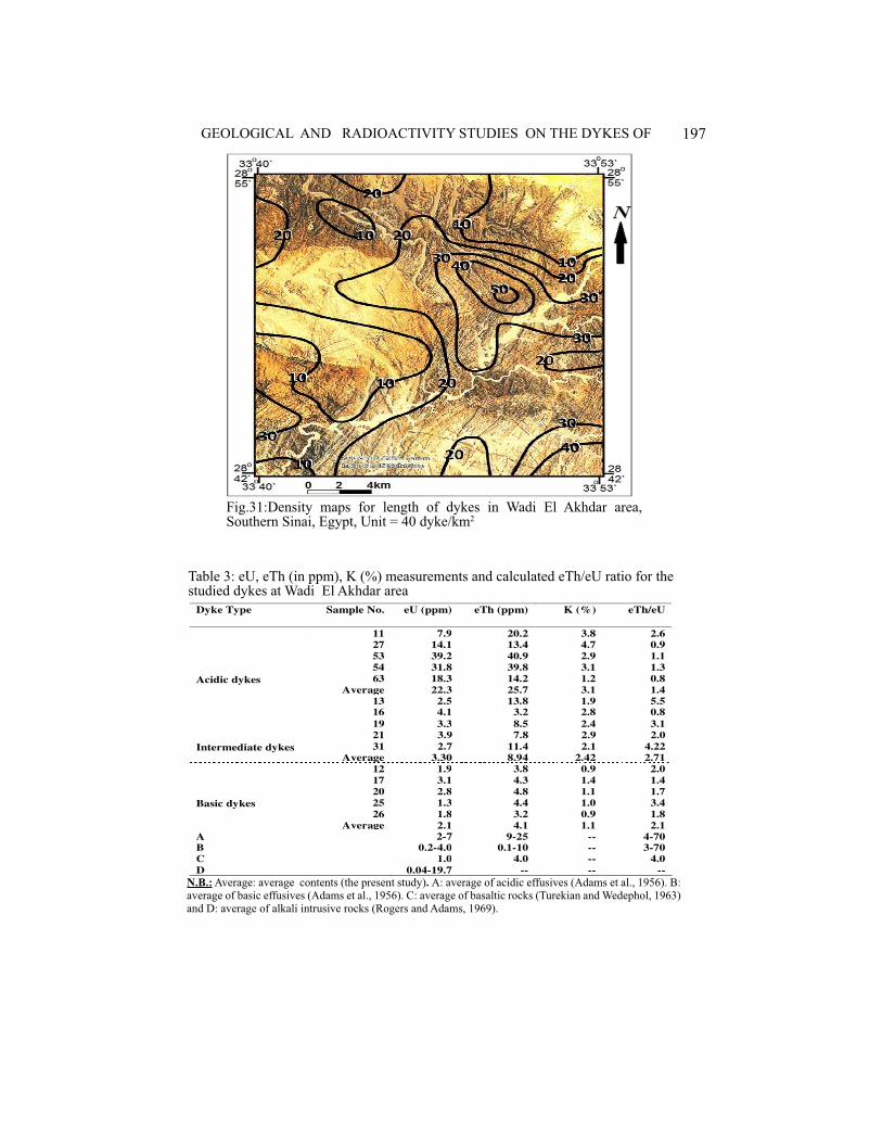
Also, the Phanerozoic Paleozoic sedimentary rocks and older granites may be responsible for low dyke density in the northeastern area, while the younger granites and volcanic rocks show moderate dyke density of both number and length. It is clear that, dyke density and dominant trend for each rock type can be used as important evidence characterizing the rock types. These clear from the dyke density maps for number (Fig.30) and length (Fig.31). These dyke density maps show zones with low, mod-erate, and high dyke density according to the different types of rocks in the mapped area. The low dyke density zone reaches 20 value, the moderate density from 30 to 40 values and the high density is more than 40 dykes.
Radioactivity of the Studied Dykes
The contents of eU, eTh in ppm, and K% as well as eTh/eU ratio in the studied dykes
are listed in Table (3). It is shown that, the acidic dykes are relatively more enriched in eU average contents (22.30 ppm) than other types of dykes (3.30 ppm in intermediate dykes and 2.10 ppm in basic dykes). On the other hand, the acidic dykes contain most eTh contents. Their average content of eTh is 25.70 ppm whereas it is 8.94 ppm in interme-diate dykes, and 4.10 ppm in basic ones. The high contents of eU in acidic dykes is related to presence of some accessory minerals such as apatite, zircon and sphene as previously mentioned petrographic study.
Regarding the comparison between the av-erage contents of eU and eTh in the studied dykes and similar igneous rocks (Table 3), it is shown that the present acidic and intermediate dykes are more enriched in eU than acidic effusives (Adams et al., 1956). On the other hand, their average content of eTh is gener-
197GEOLOGICAL AND RADIOACTIVITY STUDIES ON THE DYKES OF
�
Fig.31:Density maps for length of dykes in Wadi El Akhdar area, Southern Sinai, Egypt, Unit = 40 dyke/km2
Table 3: eU, eTh (in ppm), K (%) measurements and calculated eTh/eU ratio for the studied dykes at Wadi El Akhdar area
Dyke Type Sample No. eU (ppm) eTh (ppm) K (%) eTh/eU
Acidic dykes
11 7.9 20.2 3.8 2.6
27 14.1 13.4 4.7 0.9
53 39.2 40.9 2.9 1.1
54 31.8 39.8 3.1 1.3
63 18.3 14.2 1.2 0.8
Average 22.3 25.7 3.1 1.4
Intermediate dykes
13 2.5 13.8 1.9 5.516 4.1 3.2 2.8 0.8
19 3.3 8.5 2.4 3.1
21 3.9 7.8 2.9 2.0
31 2.7 11.4 2.1 4.22
Average 3.30 8.94 2.42 2.71
Basic dykes
12 1.9 3.8 0.9 2.0
17 3.1 4.3 1.4 1.4
20 2.8 4.8 1.1 1.7
25 1.3 4.4 1.0 3.4
26 1.8 3.2 0.9 1.8
Average 2.1 4.1 1.1 2.1
A 2-7 9-25 -- 4-70B 0.2-4.0 0.1-10 -- 3-70
C 1.0 4.0 -- 4.0
D 0.04-19.7 -- -- --
�N.B.: Average: average contents (the present study). A: average of acidic effusives (Adams et al., 1956). B: average of basic effusives (Adams et al., 1956). C: average of basaltic rocks (Turekian and Wedephol, 1963) and D: average of alkali intrusive rocks (Rogers and Adams, 1969).
198 ATEF H. ABD EL AZEEM
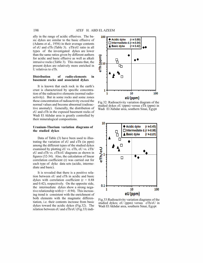
�Fig.32: Radioactivity variation diagram of the studied dykes eU (ppm) versus eTh (ppm) in Wadi El Akhdar area, southern Sinai, Egypt
�
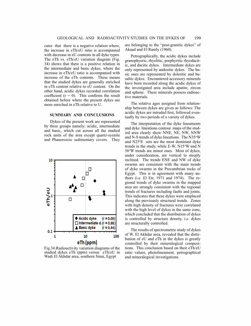
Fig.33:Radioactivity variation diagrams of the studied dykes; eU (ppm) versus eTh/eU in Wadi El Akhdar area, southern Sinai, Egypt
ally in the range of acidic effusives. The ba-sic dykes are similar to the basic effusive of (Adams et al., 1956) in their average contents of eU and eTh (Table 3). eTh/eU ratio in all types of the investigated dykes are lower than the same ratios given by different authors for acidic and basic effusive as well as alkali intrusive rocks (Table 3). This means that, the present dykes are relatively more enriched in U relatives to eTh.
Distribution of radio-elements in basement rocks and associated dykes
It is known that each rock in the earth’s crust is characterized by specific concentra-tion of the radioactive elements (normal radio-activity). But in some rocks and some zones these concentration of radioactivity exceed the normal values and become abnormal (radioac-tive anomaly). Generally, the distribution of eU and eTh in the exposed basement rocks of Wadi El Akhdar area is greatly controlled by their mineralogical compositions.
Uranium-Thorium variation diagrams of the studied dykes
Data of Table (3) have been used to illus-trating the variation of eU and eTh (in ppm) among the different types of the studied dykes examined by plotting eU vs. eTh, eU vs. eTh/eU and eTh vs. eTh/eU diagrams as shown in figures (32-34). Also, the calculation of linear correlation coefficient (r) was carried out for each type of dyke data sets (acidic, interme-diate and basic).
It is revealed that there is a positive rela-tion between eU and eTh in acidic and basic dykes with correlation coefficient (r = 0.88 and 0.42), respectively. On the opposite side, the intermediate dykes show a strong nega-tive relationship with (r = -0.94). This increas-ing trend is consistent with the enrichment of both elements with the magmatic differen-tiation, i.e. their contents increase from basic dykes toward the acidic dykes (Fig.32). The relation between eU and eTh/eU (Fig.33) indi-
199GEOLOGICAL AND RADIOACTIVITY STUDIES ON THE DYKES OF
�
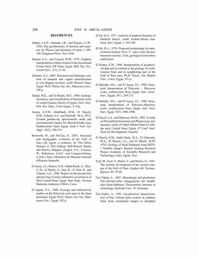
Fig.34:Radioactivity variation diagrams of the studied dykes eTh (ppm) versus eTh/eU in Wadi El Akhdar area, southern Sinai, Egypt
cates that there is a negative relation where, the increase in eTh/eU ratio is accompanied with decrease in eU contents in all dyke types. The eTh vs. eTh/eU variation diagram (Fig. 34) shows that there is a positive relation in the intermediate and basic dykes, where the increase in eTh/eU ratio is accompanied with increase of the eTh contents. These means that the studied dykes are generally enriched in eTh content relative to eU content. On the other hand, acidic dykes recorded correlation coefficient (r = 0). This confirms the result obtained before where the present dykes are more enriched in eTh relative to U.
SUMMARY AND CONCLUSIONS
Dykes of the present work are represented by three groups namely; acidic, intermediate and basic, which cut across all the studied rock units of the area except quartz-syenite and Phanerozoic sedimentary covers. They
are belonging to the “post-granitic dykes” of Akaad and El Ramly (1960).
Petrographically, the acidic dykes include granophyeric, rhyolitic, porphyritic rhyodacit-ic, and dacitic dykes. Intermediate dykes are only represented by andesitic dykes. The ba-sic ones are represented by doleritic and ba-saltic dykes. Encountered accessory minerals have been recorded along the acidic dykes of the investigated area include apatite, zircon and sphene. These minerals possess radioac-tive materials.
The relative ages assigned from relation-ship between dykes are given as follows: The acidic dykes are intruded first, followed even-tually by two periods of a variety of dykes.
The interpretation of the dyke lineaments and dyke lineations contour maps of the stud-ied area clearly show NNE, NE, NW, NNW and N-S trends of dyke lineations. The N35oW and N25oE sets are the most dominant dyke trends in the study, while E-W, N15oW and N 56oW trends are minor ones. Most of dykes, under consideration, are vertical to steeply inclined. The trends ENE and NW of dyke swarms are consistent with the main trends of dyke swarms in the Precambrian rocks of Egypt. This is in agreement with many au-thors (i.e. El Etr, 1971 and 1974). The re-gional trends of dyke swarms in the mapped area are strongly consistent with the regional trends of fractures including faults and joints. This indicates that these dykes were emplaced along the previously structural trends. Zones with high density of fractures were correlated with the high level of dykes in the same zone, which concluded that the distribution of dykes is controlled by structure density, i.e. dykes are structurally controlled.
The results of spectrometric study of dykes of W. El Akhdar area, revealed that the distri-bution of eU and eTh in the dykes is greatly controlled by their mineralogical composi-tions. This conclusion based on their eTh/eU ratio values, photolineament, petrographical and mineralogical investigations.
200 ATEF H. ABD EL AZEEM
REFERENCES
Adams, J.A.S.; Osmand, J.K., and Rogers, J.J.W.,
1956. The geochemistry of thorium and urani-
um. In: Physics and chemistry of earth, 3, 298-
348. Pergamon Press. New York.
Ahmed, A.A., and Youssef, M.M., 1976. Airphoto
interpretation of dyke swarms in the area around
Feiran Oasis, SW Sinai, Egypt. Bull. Fac. Sci.,
Assiut Univ., 5(1), 31-42.
Alshami, A.S., 2003. Structural and lithologic con-
trols of uranium and copper mineralization
in Um Bogma environs, south Western Sinai,
Egypt. Ph.D. Thesis, Fac. Sci., Mansoura Univ.,
148 p.
Akaad, M.K., and El Ramly, M.F., 1960. Geologi-
cal history and classification of basement rocks
of central Eastern Desert of Egypt. Geol. Surv.
Min. Res. Dept., Cairo Egypt., 9, 42p.
Assran, A.S.M.; Abdelhadi, H.M.; El Shayeb,
H.M.; Ashami, A.S., and Zaeimah, M.A., 2012.
Ground gamma-ray spectrometric study and
environmental impact for Moreid-Elsahu area,
Southwestern Sinai, Egypt. Arab J. Nucl. Sci.
Appl., 45(2), 240-253.
Bosworth, W., and McClay, K., 2001. Structural
and stratigraphic evolution of the Gulf of
Suez rift, Egypt: a synthesis. In: Peri-Tethys
Memoir 6: Peri-Tethyan Rift/Wrench Basins
and Passive Margins (Ziegler, P.A.; Cavazza,
W.; Robertson, A.H.F., and Crasquin-Soleau,
S.,Eds.). Paris, Memoires du Museum National
ďHistoire Naturelle.
El Aassy, I.E.; Botros, N.H.; Abdel Razik, A.; Sher-
if, H.; Al Moafy, A.; Atia, K.; El Terb, R., and
Ashami, A.S., 1986. Report on the prospection
and proving of some radioactive occurrences in
West Central Sinai, Egypt. Inter. Rept., Nuclear
Materials Authority (NMA), Cairo.
El Agami, N.L., 1996. Geology and radioactivity
studies on the Paleozoic rock units in the Sinai
peninsula, Egypt. Ph.D. Thesis, Fac. Sci., Man-
soura Univ., Egypt, 302 p.
El Etr, H.A., 1971. Analysis of airphoto lineation of
Darheeb district , south Eastern Desert. Ann.
Geol. Surv. Egypt, 1, 193-108
El Etr, H.A., 1974. Proposed terminology for natu-
ral linear features. Proc. 1st inter. Conf. the new
basement tectonic, Utah, geological association
publication
El Kattan, E.M., 1986. Interpretation of geophysi-
cal data and its relation to the geology of south-
western Sinai and its neighboring part of the
Gulf of Suez area. Ph.D. Thesis, Ain Shamis
Univ., Cairo, Egypt, 251 p.
El Rakaiby, M.L., and El Aassy, I.E., 1989. Struc-
tural interpretation pf Paleozoic – Mesozoic
rocks, southwestern Sinai, Egypt. Ann., Geol.,
Surv., Egypt, XV1, 269-273.
El Rakaiby, M.L., and El Aassy, I.E., 1990. Struc-
tural interpretation of Paleozoic-Mesozoic
rocks, southwestern Sinai, Egypt. Ann. Geol.
Surv. Egypt. XVI, 1986-1990.
El Sayed, A.A., and Mansour, M.Gh., 2003. A study
on Precambrian basement and Phanerozoic sed-
imentary rocks of Gabal Dhulal-Wadi El Akh-
dar area, Central Sinai, Egypt. 6th Conf. Geol.
Sinai for Development, Ismailia.
El Shazly, E.M.; Abdel Hady, M.A.; El Ghawaby,
M.A.; El Kassas, I.A., and El Shazly, M.M.
1974. Geology of Sinai Peninsula from ERTS-
1 Satellite images. Remote Sensing Research
Project Academy of Scientific Research and
Technology, Cairo, Egypt, 20 p.
Eyal, M.; Eyal, Y.; Bartov, Y., and Steiniz, G., 1981.
The tectonic development of the western mar-
gin of the Gulf of Elate (Aqaba) rift. Tectono-
physics, 80, 39-66.
Friz-Topfer, A., 1987. Mineralogie and geochemie
Pan-Africani-scher Ganggesteine der Suddli-
cher Sinai-Halbinsel. Dessertation, Institute of
mineralogy, Karlsuhe Univ. W. Germany.
Friz-Topfer, A., 1991. Geochemical characteriza-
tion of Pan- African dyke swarms in southern
Sinai from continental margin to intraplate
201GEOLOGICAL AND RADIOACTIVITY STUDIES ON THE DYKES OF
دراسة جيولوجية واشعاعية عن الجدد في منطقة وادي الأخضر، جنوب سيناء، مصر
عاطف حسن عبد العظيم
تتناول الدراسة الجدد المنتشر< في حيز وادي الأخضر بجنوب سيناء بين خطي عرض ٤٢' ٢٨○ و ٥٥' ٢٨○ شمالا وخطي طول٤٠' ٣٣ ○ و ٥٣' ٣٣ ○ شرقا مغطية لمساحة ٧٠٠ كم٢ معظمها من صخور الركيزة المعقدة، بينما تغطي رسوبيات الفانيروزوي صخور القاعدة بسطح
عدم توافق في شمال شرق منطقة الدراسة.ولقد أمكن بواسطة الدراسات الحقلية و البتروجرافية التمييز بين ثلاثة مجموعات من الجدد: حامضية ( جرانوفيرية- ريوليتية- ريوداسيتية بورفيرية- داسيتية)، متوسطة (انديزيتية) وقاعدية أظهرت بينما انتشارا الاكثر هي القاعدية و الحامضية أن وجد كما دولوريتية-بازلتية). )
magmatism. Precambrian Res., 49, 281-300.
Gass, I.G., 1982. Upper Proterozoic (Pan–Afri-
can) calc-alkaline magmatism in NE Africa
and Arabia. In: Andesites-orogenic andesites
and related rocks (Thrpe, R.S. ,Ed.). J. Wiley
Chichester, 591-609.
Google Earth, 2015. Updated satellite images of
the Earth Planet from the internet site; www.
Googleearth.com.
Ibrahim, S.K., 1989. Petrographical studies on
some dykes in central south Sinai and their
structural setting, south Central Sinai, Egypt.
M.Sc. Thesis, Fac. Sci. Suez Canal Univ., Is-
mailia, Egypt.
Kandil, M.K.; Abd El Azeem, A.H., and Mansour,
G.M.R., 2015. Lithostructural control of radio-
activity at Wadi El Akhdar environs, Southern
Sinai, Egypt. Egyp. J. Geol., 59, 179-195.
Khalil, S.M., 1998. Tectonic evolution of the east-
ern margin of the Gulf of Suez, Egypt. London,
Royal Holloway, University of London.
Meshref, W.M., 1990. Tectonic framework of
Egypt. In :The geology of Egypt ( Said, R.,Ed.).
Balkema, Rollerdam, 734 p.
Nasr, M.M.S., 2003. The role of basic dykes in the
distribution of uranium and other elements in
the Paleozoic rocks, southwestern Sinai, Egypt.
M.Sc. Thesis, Mansoura Univ., 132 p.
Rogers, J.J.W., and Adams, J.A.S., 1969. Uranium.
In: Handbook of Geochemistry. Edited by
Wedepohl, K.H., Springer-Verlag Heidelberg.
92 B-O p.
Sabet, A.H., 1962. Photo-interpretation of crystal-
line rocks. Institute Of Aerial Survey and Earth
Sciences (ITC) publication B, No. 14-15, Deft,
the Netherlands.
Sabet, A.H., 1968. Basic of application of aerial
photographs in geology. Geol. Surv., Egypt.,
48, 1-76.
Sadek, A.A., and Abbas, A.A., 2017. Geology, geo-
chemistry and radioactivity of dyke swarms
at Wadi El Akhdar area, Southcentral Sinai,
Egypt. Nucl. Scie. Scie. J., 6, 1-16.
Steckler, M.S.; Berthelot, F.; Lyberis, N., and LePi-
chon, X., 1988. Subsidence in the Gulf of Suez:
implications for rifting and plate kinematics,
Tectonophysics. 153, 249– 270.
Turkian, K.K., and Wedepohl, W.H., 1963. Dis-
tribution of the elements in some major units
of the earth’s crust. Bull. Geol. Soc. Am., 72,
175-192.
Zalata, A.A., 1988. On the dyke swarms of Wadi
El Akhdar area, Central Sinai, Egypt. Bull. Fac.
Sci., Mansoura Univ., 15(2), 245-269.
202 ATEF H. ABD EL AZEEM
المشاهدات الحقلية أن الجدد القاعدية هي الأحدث عمرا من الحامضية و المتوسطة. حيث اقحمت الجدد الحامضية أولا، تليها في نهاية المطاف فترتين من مجموعه متنوعه من الجدد.
كما جري استخدام كل من الصور الجوية بمقياس رسم ١: ٤٠٫٠٠٠ و الموزيك مقياس رسم ١: ٥٠٫٠٠٠ و كذلك الاستعانة بالخرائط الطبوغرافية بمقياس رسم ١: ٥٠٫٠٠٠ في التفسيرات الفوتوجيولوجية للقواطع بجهاز الاستريوسكوب ذو المر+ة (نظام زايس) ، وتحليل الأنماط الخطيه بالاستعانه الجدد، من نوع لكل المميزة المعدنية و النسيجية الخصائص ودرست لها. الممثلة بالدراسات البتروجرافية. وظهر احتواء الحامضية منها علي معادن هامشية ( الأباتيت، الزيركون و السفين) بها مواد مشعة. وقد بينت دراسة الأنماط الخطية للقواطع المختلفة بالطرق الكمية أن ٣٥,٤) بنسب غرب شمال و شرق شمال ، شرق شمال شمال اتجا< ذات كثافة الأعلي الجدد ،٢٤,٤ و ١٢,١ ٪) علي الترتيب . بينما كانت الجدد الأكثر طولا ذات امتدادات شمال شمال شرق ، شمال شرق و شمال غرب بنسب ( ٣٦,١ ، ٢٣,١ و ١٢,٥ ٪) علي الترتيب . وخلصت الدراسة الي أن المناطق ذات الكثافة العالية للكسور مرتبطة بمستوي الكثافة العالية للقواطع في
نفس المنطقة، التي خلصت الي أن توزيع الجدد متحكم به تركيبيا. إشعاعيا، احتوت الجدد الحامضيه علي قياسات أعلي في مكافيء اليورانيوم( بمتوسط ٢٢,٣ جزء في المليون ) عن كل من القاعدية و المتوسطة ( متوسط= ٣,٣ و ٢,١ جزء في المليون علي الترتيب). ومن ناحيه أخري كان متوسط مكافيء الثوريوم ( ٢٥,٧ ، ٨,٩ و ٤,١ ) علي الترتيب . و يعزي ذلك لوجود بعض المعادن الهامشية الحاوية للمواد المشعة ( الأباتيت ، الزيركون و
السفين) في تركيب الجدد الحامضية.


![Geochemistry and Petrogenesis of Diabase Dykes in the ... · especially on the diabase dykes and mineralization episode [4]. In the present study, a few representative dykes occurring](https://img.pdfslide.us/doc/110x75/5e86f37100131427f470b86f/geochemistry-and-petrogenesis-of-diabase-dykes-in-the-especially-on-the-diabase.jpg)