1
7 2 5 2 4 3 2 1 12 5 1 3 2 4 2 14 5 2 3 2 3 3 2 2 5 2 3 5 5 5 5 5 10 20 15 25 25 20 15 15 10 20 30 20 20 10 20 10 20 10 10 15 10 10 10 20 20 20 25 10 30 30 2 5 20 5 5 5 0 15 40 10 30 30 75 5 15 10 10 20 15 20 40 25 75 15 15 40 30 20 25 40 15 10 25 10 10 5 50 45 10 15 30 25 60 5 20 20 10 25 10 20 10 25 20 30 3 3 3 5 2 2 5 2 3 3 3 3 2 15 20 25 10 40 25 10 100 3 5 5 5 3 10 20 10 10 10 10 15 10 20 10 25 30 60 25 260 3 5 5 3 5 3 5 5 50 20 20 10 10 10 45 35 45 15 90 30 40 15 20 20 15 20 20 10 40 25 40 100 220 240 40 2 3 20 15 5 10 76 Qdl Qes Qdb Qg1 Qs Qaf Qf Qd Qa1 Qa2 Qg2 Qps Qae Qsc Qdc Ql Qv Qtr Qg3 Qa3 Qmcb Qb Qmlp Qsfp Qwb Ts ^cp ^cs ^mhm ^mss ^mw Pkh Pkf Pt QTb Qmb Qmp Qmbi Tbpb Qaf Qs Qf Qd Qes Qdl Qdb Qg1 Qa1 Qg2 Qa2 Qps Qae Qdc Qsc Qtr Ql Qv Qg3 Qa3 Qmcb Qb Qsfp Qmbi Qmp Qmb Qmlp Qwb QTb Tbpb Ts ^cp ^cs ^mhm ^mss ^mw Pkf Pt Pkh Qf Qv Q Qv Qa1 Qg1 Qes Qdc Pkh Qtr Qa1 Qg1 Qa1 ^mw ^mw Qdc Qmlp Qmlp ^mss Pkh Qes Tbpb Qmb Qa1 Qv Qv Qa1 Qg3 Qv Qf Qs Qd Qd Qf Qs Qd Qd Qd Qf Qd Qd Pt Qs Qs Qd Qv Qa1 Qg1 Qdb ^cs Qps ^cs ^mw Qa1 Qps Qes Qa1 Qes Qg1 Qae Qae Qae Qa3 Qg1 Qa2 Qa1 Qg2 Qa1 Qg1 ^cs Qg1 ^mw Qa1 Qes Qg3 Qa1 Qtr Qg1 Qa1 Qa2 Qtr Qa3 Qdc Qg3 ^mw Qa1 Qg3 Qes Qa1 Qae Qa3 ^mw Qa1 Qa1 Qaf Qa2 Qa1 Qg1 Qes a Qa1 Qa2 Qps Qps Qg2 Qa1 Qa2 Qdc Qa1 Qsc ^cp Qa1 ^mhm ^mhm ^mhm Ts ^mhm ^mhm Qmcb ^mhm ^mss Qmcb ^mhm ^mss Qdl Qa2 Qd Qs Qs Qs Ts Pt Pkh Qs Qs Qf Qd Qs Qs Ts Qf Qv Qv Pkf Pt Qg3 Qg2 Qe Qes Qg1 ^mw Qa3 Qa2 Qg1 Qa2 Qa1 Qa1 Qg2 Qes Qes Qes Qa1 Qa1 Qa2 Qg1 Qtr Qa2 Qg1 Qa1 Qa1 Qsc Qg1 Pkh Qa3 Qa1 Qa2 Qg2 Qdc Qa1 Qg1 Qes ^mw Qaf Qaf Qaf Qtr Qa1 Qg2 Qg2 Qg1 Qa1 Qa1 Qa2 Pk Qae Qmb ^mhm ^mhm ^mss ^mhm ^mhm Qmcb ^mhm ^mss ^mss ^mhm Qmbi Qa1 Qd Pkh Qv Qv Qs Qs Qv Ql Qs Qs Qb Qv Qs Ql Qv Qs Qs Qa1 Pkh ^mw Qaf Qtr Qdc Qdc Qaf Qtr Qa1 Pkh Qsc Qdc Qdc Qsc Qdc Qsc Qdc Qps Qps Qvf Qae Qsc Qps Qg1 Pkh Qdc Qdc Qsc Qa2 Qa1 Qa2 Pkh Qps Qae Qg1 Qa1 Qmb Qaf Qdc Qsc Qae Qa1 Qsc Qmb Qaf Qmb Qdc Qps Qa1 Qdc Qa2 Qdc Qg2 Qdc Qsc Qa2 Qsc Qsfp Tbpb Tbpb Tbpb Tbpb Tbpb Tbpb Qaf Pkh Qsc Qb Qmb Qdc Qv Qs Qps ^mw Qa2 Qae Qg3 Qg2 Qa2 Qa1 Qdc Qmp Qa3 Qg1 Qsc Qa1 Qaf ^mss Qv Qs Qv ^mw Qa3 Qsc Qtr Qsc Qps Qdc Qtr Qsc Qdc Qa1 Qa3 ^mw Qa2 Qa3 ^mw ^mhm ^mhm Qwb ^mss ^mss ^mss Qv ^m Pkh Qb Ts Qs Qv Qv Qv Ql Ql Qv Ql Pkh Pkh Qsc Qmb Qg2 Qdc Qa1 Qa1 ^mw ^mw Qa1 Qdc Qdc Qmp Qmb Qa2 Qa1 Qsc ^mw Qa1 Qa1 Qdc Qdc Qtr QTb Pkf ^mw ^mw Qsc Qa1 Qtr Qa1 Qae Qaf Qa2 Qdc Qa3 Qa2 Qdc Qdc Qsc Qsc ^mw Qa2 Qps Qtr Qdc Qtr Qdc Qg1 Qg1 Qa2 Qa1 Qae ^mhm Tbpb ^mss ^mhm ^mss Qwb ^mss Qwb Ql ^mw Qa ^mw Qdc Qmp Qae f Ts f Qaf Pliocene Upper Triassic Lower Triassic Middle(?) Triassic Lower Permian PERMIAN Holocene Pleistocene Pleistocene QUATERNARY QUATERNARY CORRELATION OF MAP UNITS SURFICIAL DEPOSITS VOLCANIC ROCKS Volcanic Rocks of the San Francisco Volcanic Field SEDIMENTARY ROCKS TERTIARY TERTIARY TRIASSIC Pliocene or Miocene(?) Unconformity Unconformity Unconformity Unconformity LIST OF MAP UNITS SURFICIAL DEPOSITS Artificial fill and quarries (Holocene) Stream-channel deposits (Holocene) Flood-plain deposits (Holocene) Dune sand and sand sheet deposits (Holocene) Young eolian sand sheet deposits (Holocene) Young linear dune deposits (Holocene) Young barchan dune deposits (Holocene) Young terrace-gravel deposits (Holocene) Young alluvial fan deposits (Holocene) Intermediate terrace-gravel deposits (Holocene and Pleistocene(?)) Intermediate alluvial fan deposits (Holocene and Pleistocene(?)) Ponded sediments (Holocene and Pleistocene(?)) Young mixed alluvium and eolian deposits (Holocene and Pleisto- cene(?)) Eolian cinder dune deposits (Holocene and Pleistocene) Eolian cinder sand sheet deposits (Holocene and Pleistocene) Talus and rock fall deposits (Holocene and Pleistocene) Landslide deposits (Holocene and Pleistocene) Valley-fill deposits (Holocene and Pleistocene) Old terrace-gravel deposits (Pleistocene) Old alluvial fan deposits (Pleistocene) VOLCANIC ROCKS Volcanic Rocks of the San Francisco Volcanic Field (Pleistocene, Pliocene, and Miocene) Basalt flow of Merriam Crater (Pleistocene; Brunhes age) Basalt flows (Pleistocene; Brunhes age) Pumice of San Francisco Mountain (Pleistocene; Matuyama age) Basalt dike (Pleistocene; Matuyama age) Pyroclastic deposits (Pleistocene; Matuyama age) Basalt flows (Pleistocene; Matuyama age) Basalt flow of Lava Point (Pleistocene; Matuyama age) Basalt flows of Woodhouse Mesa (Pleistocene; Matuyama age) Basalt flows (Pleistocene(?) or Pliocene; Matuyama age) Black Point Basalt (Pliocene) SEDIMENTARY ROCKS Oldest stream-channel deposits (Pliocene or Miocene(?)) Chinle Formation (Upper Triassic) Petrified Forest Member Shinarump Member Moenkopi Formation (Middle(?) and Lower Triassic) Moqui and Holbrook Members, undivided (Middle(?) and Lower Triassic) Lower massive sandstone member (Lower Triassic) Wupatki Member (Lower Triassic) Kaibab Formation (Lower Permian) Harrisburg Member Fossil Mountain Member Toroweap Formation, undivided (Lower Permian) EXPLANATION Contact Fault—Dashed where inferred or approximately located; dotted where concealed; bar and ball on downthrown side. Faults shown as bounding alluvium do not offset alluvium. Number is estimated displacement in feet Folds—Showing trace of axial surface and direction of plunge; dotted where concealed Monocline—Dashed where approximately located Strike and dip of beds Inclined—Measured in the field Implied—Interpreted from aerial photographs; dip amount not determined Strike of vertical and subvertical joints Sinkhole—Enclosed depression or cave Flow direction of basalt Volcanic vent Fracture—Open fracture without offset Offset fracture—Open fracture with offset Base from U.S. Geological Survey, 1:24,000, Gray Mountain, Wupatki NE, Wupatki SW, and Wupatki SE, 1969, and East of SP Mountain, 1989 Universal Transverse Mercator Projection 1927 North American Datum Clark 1866 Ellipsoid, Zone 1 SCALE 1:24 000 CONTOUR INTERVAL 10 AND 20 FEET 1 1/2 0 1 MILE 1 .5 0 1 KILOMETER Geology mapped in 2005–2006 by G.H. Billingsley Digital database by S.S. Priest and T.J. Felger Edited by Carolyn A. Donlin; design and layout by Darlene A. Ryan Manuscript approved for publication January 23, 2007 11 / ° 1 2 MAGNETIC NORTH APPROXIMATE MEAN DECLINATION, 2007 TRUE NORTH Any use of trade, product, or firm names in this publication is for descriptive purposes only and does not imply endorsement by the U.S. Government. For sale by U.S. Geological Survey, Information Services, Box 25286, Federal Center, CO 80225, 1–888–ASK–USGS Digital files available at http://pubs.usgs.gov/sim/2007/2958 Printed on recycled paper Geologic Map of Wupatki National Monument and Vicinity, Coconino County, Northern Arizona By George H. Billingsley, Susan S. Priest, and Tracey J. Felger 2007 Prepared in cooperation with the National Park Service and the Navajo Nation U.S. Department of the Interior U.S. Geological Survey Scientific Investigations Map 2958 Pamphlet accompanies map MOUNTAIN FAULT DONEY BLACK P OINT M O N O C LI N E BLACK POINT MONOCLINE BLACK POINT MONOCLINE View looking west toward Doney Mountain Fault, at Antelope Wash. Photograph courtesy of National Park Service, Wupatki National Monument. View looking west at Cathedral Canyon near Doney Mountain Fault showing the Kaibab Formation. Photograph by G.H. Billingsley, 2004. ARIZONA 111°30'00" 111°27'30" 111°25'00" 111°22'30" 111°20'00" 111°17'30" 35°30’00" 35°32’30" 35°37'30" 35°35’00" 111°17'30" 111°20'00" 111°22'30" 111°25'00" 111°27'30" 111°30'00" 35°37'30" 35°35'00" 35°30'00" 35°32'30" MAP LOCATION

Geologic Map of Wupatki National Monument and Vicinity ... · Qv Q s Qs Qv Ql Qs Qs Qb Qv Qs Ql Qv Qs Qs 1 h w Qa f c Qt r c Qa f Qt r Qa1 Pkh Qs c Qd c Qd c Qsc Q dc Q c Qdc ps Qvf

Embed Size (px)

Citation preview

7

2

5

2

4

3

2

1

12

5

1

3

2

4

2

14

5

2

3

233

2

2

5

2

3

5

5

5

5

5

10

20

15

25

25

20

1515

10

20

30

20

20

10

20

10

20

10

10

15

101010

2020

20

25

10

30

30

2

5

20

5

5

50

15

4010

30

30

75

5

15

10

10

2015

20

40

25

75

15

15

40

3020 25

40

1510

25

10

10

5

50

45

10

15

30

2560

5

20

20

10

25

10

20

10

25

20

30

3

33

5

2

2

5

2

3

3

3

3

2

15

20

25

10

40

25

10

100

3

5

5

5

3

10

20

10

10

10

10

15

10

20

10 25

30

60

25

260

3

55

3

5

3

5

5

50

20

20

10

10

10

45

35

45

15

90

30

40

15

20

20

15

20

20

10

4025

40

100

220

240

40

23

2015

5

10

76

QdlQes Qdb Qg1QsQaf Qf Qd Qa1Qa2Qg2 Qps Qae

QscQdc Ql QvQtrQg3 Qa3

Qmcb Qb QmlpQsfp Qwb

Ts

^cp

^cs

^mhm

^mss

^mw

Pkh

Pkf

Pt

QTb

Qmb

QmpQmbi

Tbpb

Qaf

Qs

Qf

Qd

Qes

Qdl

Qdb

Qg1

Qa1

Qg2

Qa2

Qps

Qae

Qdc

Qsc

Qtr

Ql

Qv

Qg3

Qa3

Qmcb

Qb

Qsfp

Qmbi

Qmp

Qmb

Qmlp

Qwb

QTb

Tbpb

Ts

^cp

^cs

^mhm

^mss

^mw

Pkf

Pt

Pkh

QfQv

Q

Qv

Qa1

Qg1

Qes

Qdc

Pkh

Qtr

Qa1

Qg1

Qa1

^mw

^mw

Qdc

Qmlp

Qmlp

^mss

Pkh Qes

Tbpb

Qmb

Qa1

Qv

Qv

Qa1

Qg3

Qv

Qf

Qs

Qd

QdQf

Qs

Qd

Qd

Qd

Qf

QdQd

Pt

Qs

Qs

Qd

Qv

Qa1

Qg1Qdb

^cs

Qps

^cs

^mw

Qa1

Qps

Qes

Qa1

Qes

Qg1

Qae

Qae

Qae

Qa3

Qg1

Qa2

Qa1

Qg2Qa1

Qg1

^cs

Qg1

^mwQa1

Qes

Qg3

Qa1Qtr

Qg1

Qa1

Qa2Qtr

Qa3

QdcQg3

^mwQa1

Qg3

QesQa1

Qae

Qa3

^mw

Qa1

Qa1Qaf Qa2

Qa1

Qg1Qes

a

Qa1

Qa2Qps

Qps

Qg2

Qa1

Qa2Qdc

Qa1

Qsc

^cp

Qa1

^mhm

^mhm

^mhm

Ts

^mhm

^mhmQmcb

^mhm

^mss

Qmcb

^mhm

^mss

Qdl

Qa2

Qd

Qs

Qs

Qs

Ts

Pt

Pkh

Qs

Qs

QfQd

Qs

Qs

Ts

Qf

Qv

Qv

Pkf

Pt

Qg3

Qg2

Q e

Qes

Qg1^mw

Qa3

Qa2 Qg1

Qa2Qa1

Qa1

Qg2

Qes

Qes

Qes

Qa1

Qa1

Qa2

Qg1

Qtr

Qa2

Qg1

Qa1

Qa1

Qsc

Qg1

Pkh

Qa3Qa1

Qa2

Qg2Qdc

Qa1

Qg1

Qes

^mw

Qaf

Qaf

Qaf

Qtr

Qa1

Qg2

Qg2Qg1

Qa1 Qa1

Qa2

Pk

Qae

Qmb

^mhm

^mhm

^mss

^mhm

^mhm

Qmcb

^mhm

^mss

^mss

^mhmQmbi

Qa1

Qd

Pkh

Qv

Qv

Qs

Qs

Qv

Ql

Qs

Qs

QbQv

Qs

Ql

Qv

Qs

Qs

Qa1

Pkh

^mwQaf

QtrQdc

Qdc

Qaf

Qtr

Qa1

Pkh

Qsc

QdcQdc

Qsc

Qdc

Qsc

Qdc

Qps

QpsQvf

Qae

Qsc

Qps

Qg1

Pkh

QdcQdc

Qsc

Qa2Qa1

Qa2

PkhQps

Qae

Qg1

Qa1

Qmb

Qaf

Qdc

Qsc

Qae

Qa1Qsc

Qmb

Qaf

Qmb

Qdc

Qps

Qa1

Qdc

Qa2

Qdc

Qg2

QdcQsc

Qa2

Qsc

Qsfp

Tbpb

Tbpb

Tbpb

Tbpb

Tbpb

Tbpb

Qaf

Pkh

Qsc

Qb

Qmb

Qdc

Qv

Qs

Qps

^mw

Qa2 Qae

Qg3

Qg2 Qa2

Qa1

Qdc

Qmp

Qa3

Qg1

Qsc

Qa1

Qaf

^mss

Qv

Qs

Qv

^mw

Qa3

QscQtr

Qsc

Qps

QdcQtr

Qsc

Qdc

Qa1

Qa3

^mw

Qa2

Qa3

^mw

^mhm

^mhm

Qwb

^mss

^mss

^mss

Qv

^m

Pkh

Qb

Ts

Qs

Qv

Qv

Qv

Ql

Ql

Qv

Ql

Pkh

Pkh

Qsc

Qmb

Qg2

Qdc

Qa1

Qa1

^mw

^mw

Qa1Qdc

Qdc

Qmp

Qmb

Qa2

Qa1

Qsc

^mw

Qa1

Qa1

Qdc

QdcQtr

QTb

Pkf

^mw

^mw

Qsc

Qa1Qtr

Qa1

Qae

Qaf

Qa2Qdc

Qa3

Qa2

Qdc

Qdc

Qsc

Qsc

^mw

Qa2

Qps QtrQdc

QtrQdc

Qg1

Qg1

Qa2

Qa1

Qae

^mhm

Tbpb

^mss

^mhm

^mss

Qwb

^mss

Qwb

Ql

^mw

Qa

^mw

Qdc

Qmp Qae

f

Ts

f

Qaf

Pliocene

Upper Triassic

Lower Triassic

Middle(?) Triassic

Lower Permian PERMIAN

Holocene

Pleistocene

Pleistocene

QUATERNARY

QUATERNARY

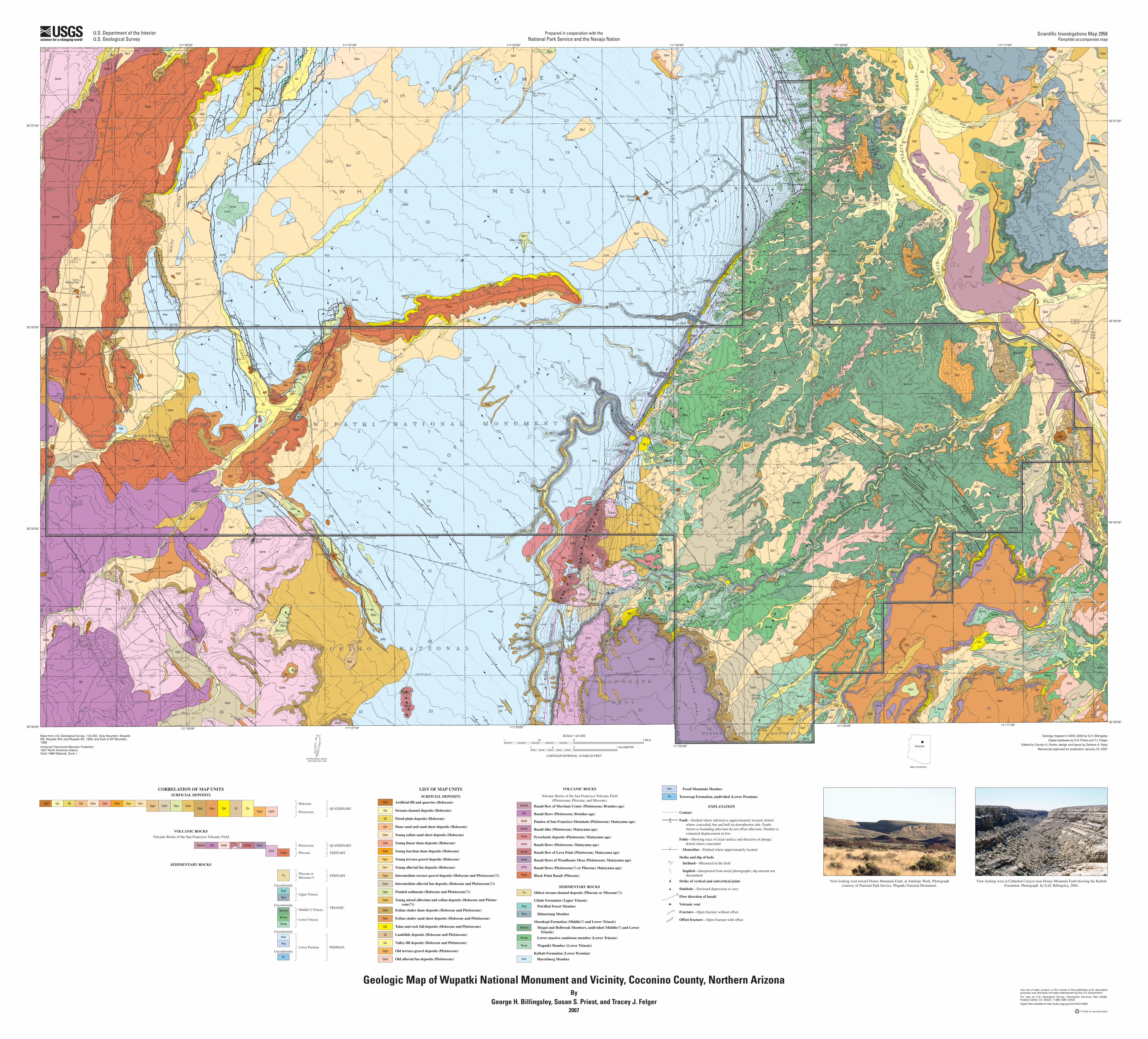
CORRELATION OF MAP UNITSSURFICIAL DEPOSITS

VOLCANIC ROCKS

Volcanic Rocks of the San Francisco Volcanic Field

SEDIMENTARY ROCKS

TERTIARY

TERTIARY

TRIASSIC

Pliocene orMiocene(?)

Unconformity

Unconformity

Unconformity

Unconformity

LIST OF MAP UNITS

SURFICIAL DEPOSITS

Artificial fill and quarries (Holocene)

Stream-channel deposits (Holocene)

Flood-plain deposits (Holocene)

Dune sand and sand sheet deposits (Holocene)

Young eolian sand sheet deposits (Holocene)

Young linear dune deposits (Holocene)

Young barchan dune deposits (Holocene)

Young terrace-gravel deposits (Holocene)

Young alluvial fan deposits (Holocene)

Intermediate terrace-gravel deposits (Holocene and Pleistocene(?))

Intermediate alluvial fan deposits (Holocene and Pleistocene(?))

Ponded sediments (Holocene and Pleistocene(?))

Young mixed alluvium and eolian deposits (Holocene and Pleisto-cene(?))

Eolian cinder dune deposits (Holocene and Pleistocene)

Eolian cinder sand sheet deposits (Holocene and Pleistocene)

Talus and rock fall deposits (Holocene and Pleistocene)

Landslide deposits (Holocene and Pleistocene)

Valley-fill deposits (Holocene and Pleistocene)

Old terrace-gravel deposits (Pleistocene)

Old alluvial fan deposits (Pleistocene)

VOLCANIC ROCKS

Volcanic Rocks of the San Francisco Volcanic Field(Pleistocene, Pliocene, and Miocene)

Basalt flow of Merriam Crater (Pleistocene; Brunhes age)

Basalt flows (Pleistocene; Brunhes age)

Pumice of San Francisco Mountain (Pleistocene; Matuyama age)

Basalt dike (Pleistocene; Matuyama age)

Pyroclastic deposits (Pleistocene; Matuyama age)

Basalt flows (Pleistocene; Matuyama age)

Basalt flow of Lava Point (Pleistocene; Matuyama age)

Basalt flows of Woodhouse Mesa (Pleistocene; Matuyama age)

Basalt flows (Pleistocene(?) or Pliocene; Matuyama age)

Black Point Basalt (Pliocene)

SEDIMENTARY ROCKS

Oldest stream-channel deposits (Pliocene or Miocene(?))

Chinle Formation (Upper Triassic)

Petrified Forest Member

Shinarump Member

Moenkopi Formation (Middle(?) and Lower Triassic)

Moqui and Holbrook Members, undivided (Middle(?) and Lower Triassic)

Lower massive sandstone member (Lower Triassic)

Wupatki Member (Lower Triassic)

Kaibab Formation (Lower Permian)

Harrisburg Member

Fossil Mountain Member

Toroweap Formation, undivided (Lower Permian)

EXPLANATION

Contact

Fault—Dashed where inferred or approximately located; dotted where concealed; bar and ball on downthrown side. Faults shown as bounding alluvium do not offset alluvium. Number is estimated displacement in feet

Folds—Showing trace of axial surface and direction of plunge; dotted where concealed

Monocline—Dashed where approximately located

Strike and dip of beds

Inclined—Measured in the field

Implied—Interpreted from aerial photographs; dip amount not determined

Strike of vertical and subvertical joints

Sinkhole—Enclosed depression or cave

Flow direction of basalt

Volcanic vent

Fracture—Open fracture without offset

Offset fracture—Open fracture with offset

Base from U.S. Geological Survey, 1:24,000, Gray Mountain, Wupatki NE, Wupatki SW, and Wupatki SE, 1969, and East of SP Mountain, 1989

Universal Transverse Mercator Projection1927 North American DatumClark 1866 Ellipsoid, Zone 1

SCALE 1:24 000

CONTOUR INTERVAL 10 AND 20 FEET

1 1/2 0 1 MILE

1 .5 0 1 KILOMETER

Geology mapped in 2005–2006 by G.H. Billingsley

Digital database by S.S. Priest and T.J. Felger

Edited by Carolyn A. Donlin; design and layout by Darlene A. Ryan

Manuscript approved for publication January 23, 2007

11 / °1 2

MA

GN

ET

IC

NO

RT

H

APPROXIMATE MEANDECLINATION, 2007

TR

UE

N

OR

TH

Any use of trade, product, or firm names in this publication is for descriptive purposes only and does not imply endorsement by the U.S. Government.

For sale by U.S. Geological Survey, Information Services, Box 25286, Federal Center, CO 80225, 1–888–ASK–USGS

Digital files available at http://pubs.usgs.gov/sim/2007/2958

Printed on recycled paper

Geologic Map of Wupatki National Monument and Vicinity, Coconino County, Northern ArizonaBy

George H. Billingsley, Susan S. Priest, and Tracey J. Felger2007

Prepared in cooperation with theNational Park Service and the Navajo Nation

U.S. Department of the InteriorU.S. Geological Survey

Scientific Investigations Map 2958Pamphlet accompanies map

MO

UN

TAIN

FA

ULT

DO

NE

Y

BLA

CK

P

OIN

T

MO

NO

CLI

NE

BLA

CK

PO

INT

MO

NO

CLIN

E

BLAC

K PO

INT

MO

NOCLI

NE

View looking west toward Doney Mountain Fault, at Antelope Wash. Photograph courtesy of National Park Service, Wupatki National Monument.

View looking west at Cathedral Canyon near Doney Mountain Fault showing the Kaibab Formation. Photograph by G.H. Billingsley, 2004.

ARIZONA

111°30'00" 111°27'30" 111°25'00"

111°22'30"

111°20'00" 111°17'30"35°30’00"

35°32’30"

35°37'30"

35°35’00"

111°17'30"111°20'00"111°22'30"111°25'00"111°27'30"111°30'00"

35°37'30"

35°35'00"

35°30'00"

35°32'30"

MAP LOCATION