Embed Size (px)
Citation preview
M. I. DAILY* , T. FARR
C. ELALHI Je t Propulsion Laboratory
California Institute of Technology Pasadena, C A 91 103
G . SCHABER U.S. Geological Survey
Branch of Astrogeologic Studies Flagstaff, AZ 86001
Geologic Interpretation from Composited Radar and Landsat Imagery
Composition and surface texture in Death Valley, California were discriminated by using like-polarized and cross-polarized synthetic-aperture radar composited with Landsat imagery.
INTRODUCTION flectance data derived from a Landsat multi-
T HE PURPOSE of this study was to obtain spectral image. Previous work involving accurate discrimination of surficial radar-Landsat combinations has concen-
geologic units in Death Valley, California by trated on using imaging radar data to provide combining information on microwave scat- an apparent increase in resolution and to ac-
ABSTRACT: Dual polarization L-band ( A = 25 c m ) radar imagery and Landsat multispectral scanner (MSS) data from central Death Valley have been computer processed and combined digitally i n order to utilize the complementary information contained i n multisensor data sets. Physically, like-polarized radar data gives roughness in- formation o n a scale proportional to radar wavelength. Cross- polarized data adds information on the overall roughness, particle shape, and packing density. Visible and near z~ref lect ivi t ies pertain to surface chemistry. Surficdal geologic units i n Death Valley are defined on the basis of compositional and textural differences: opti- cal and microwave scattering properties encoded in the multisensor image are sufficient to discriminate most of the units. This synergis- tic effect is most pronounced for the alluvial fans. Using radar scat- tering data and measured sun angle, passively-sensed (passive mi- crowave, visible, near ZR) images can be corrected for shadowing effects.
tering and depolarization from L-band centuate relief through "low sun-angle" ef- (25-cm wavelength) radar images with re- fects (Harris and Graham, 1976). In this
study we have used radar data acquired at * Also with the Department of ~ ~ ~ l ~ ~ i ~ ~ l sci- steep incidence angles (0 = O" to 45") over a
ences, University of California, Santa Barbara, CA nearly flat terrain (slopes -3") so that oh- 93106. served radar return is dominated by prop-
I PHOTOGRAMMETRIC ENGINEERING AND REMOTE SENSING, Vol. 45, No. 8, August 1979, pp. 1109-1116.
PHOTOGRAMMETRIC ENGTNEERINC & REMOTE SENSING, 1979
erties of the surface rather than by imaging geometry. In this exploratory study we have used processed synthetic-aperture radar (SAR) data acquired in like-polarized (vv) and cross-polarized (VH) modes and a total inten- sity Landsat image, which is "panchromatic" over the range from green (0.6 pm) to near infrared (1.1 pm).
Multispectral Scanner (MSS) imagery from Landsat 2 was used in this study. MSS data are obtained in four bands: green (0.5 - 0.6 pm), red (0.6 - 0.7 pm), IRl(0.7 - 0.8 pm), and IR2 (0.8 - 1.1 pm). The wide swath width (185 km) and moderate ground resolution (80 m) make Landsat imagery particularly useful for large-scale studies.
The brightness of the images generated by the MSS is a function of (1) surface spectral reflectance, (2) solar irradiance at the sur- face, (3) atmospheric transmission, (4) in- strument response, and (5) scattering of sun- light by the atmosphere along the imaging line of sight. Generally, in a good and cloud-free Landsat frame, all the above pa-
rameters but the first one are nearly con- stant.
Reflectance of rocks and minerals in the visible and near infrared regions of the spectrum are controlled by electronic tran- sitions in transition metal ions and, in the shorter visible and ultraviolet wavelengths, by electron transfer between ions. Iron in its two oxidation states is responsible for the color of most rocks and minerals in the field.
Rock type discrimination using spectral reflectance is difficult because the MSS sees only the weathered surfaces of rocks. The spectral reflectivity of weathered rocks is controlled by the abundance and oxidation state of iron. Coatings, such as desert var- nish, can mask the original spectral signature of a rock. In addition, vegetation, which has a high reflectance in the near infrared, limits the usefulness of the two near infrared bands for geologic purposes in areas of vegetative cover (Rowan et al. , 1974; Siegal and Goetz, 1977).
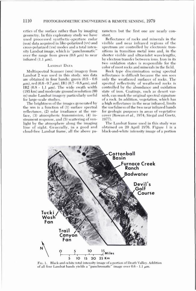
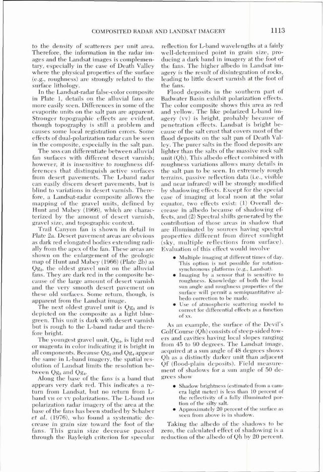
The Landsat frame used in this study was obtained on 20 April 1976. Figure 1 is a black-and-white intensity image of a portion
5 10 15 20 25 Km FIG. 1. Black-and-white total intensity image of a portion of Death Valley. Addition of all four Landsat bands ~ i e l d s a "panchromatic" image over 0.6 - 1.1 pm.
COMPOSITED RADAR AND LANDSAT IMAGERY
of that frame showing Death Valley. Differ- ences in reflectance are apparent in the sur- rounding mountains, the giant alluvial fans on the west side of the valley, and the salt pan at the bottom of the valley. Linear fea- tures are also clearly discernible.
Reflectance variations on the alluvial fans in Death Valley correlate with differences in amount of desert varnish. Desert varnish is a dark brown to black coating that forms on exposed surfaces of rocks of all lithologies in most desert regions. Recent work by Potter and Rossman (1977 a,b) indicates that the coating is composed of 70 to 90 percent clay minerals with a small amount of manganese and iron oxides which supply the color. Ma- terial for the varnish appears to be derived from outside sources, such as windblown sediment, and not the rock substrate (Potter and Rossman, 1977 a,b).
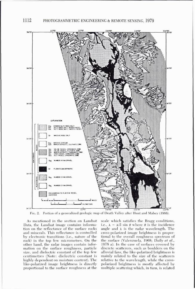
Three aluvial fan gravel units (Qg,, Qg,, and Qg,) were mapped by Hunt and Mabey (1966). Qg, is the oldest and forms elevated remnants which preserve the original fan form. The surface of the number 2 gravel is a smooth desert pavement of interlocking fragments of disintegrated pebbles and cob- bles. The desert pavement is a very stable surface which has enabled a dark coating of desert varnish to develop.
Desert varnish is also well-developed on the gravel of intermediate age, Qg,. These gravels stand slightly above present washes and are less weathered than Qg,. The fact that both Qg, and Qg3 have a coating of des- ert varnish, even though they differ in age, makes them hard to separate in Landsat im- agery. Variations in reflectance exist, but these do not correlate with the units of Qg, and Qg,. A correlation does exist, however, between the lightest areas on the fans and the youngest gravel unit, Qg,. This unit oc- cupies the presently active channels on the fans and, because of frequent abrasion, has very little desert varnish.
The evaporite units on the floor of Death Valley have inconsistent and ambiguous signatures at visible and near-infrared wavelengths. The rough facies of the silty rock salt unit, Qhr, while not shown sepa- rately on the geologic map of Figure 2, ap- pear as bright spots approximately 1 km east of the base of Trail Canyon fan. They also appear as a dark patch about 10 km south of Furnace Creek Ranch. Adjacent to this patch on its northeast side is a lighter patch which is a continuation of Qhr, Qhe (eroded salt unit), and some Qhs (smooth facies, silty rock salt unit). This area has a grey tone very similar to that of the massive rock salt unit
(Qh) of Badwater Basin. This could be due to a combination of factors, including silt mixed with Qhr and Qhs and shadowing effects in the rougher Qhe and Qh. Lighter tones characterize many evaporite units. Flood plain deposits (Qf) with their thin, clean salt crusts, and most exposures of Qhe and Qhs in the Cottonball Basin all appear in light tones.
Geologic applications of imaging radars have included comparative studies of allu- vial fans (Daily, 1975) and studies of alluvial and evaporite units in Death Valley (Schaber et al., 1976).
For the three important alluvial units in Death Valley, Schaber e t al. (1976) found that desert pavement (Qg, on Figure 2) was readily distinguished from the younger of the upper Pleistocene fan gravels (Qg, and the recent fan gravels (Qg,) on the basis of L-band radar backscatter. The very low radar return from the desert pavement is a conse- quence of the smoothness of the surface, whereas the two fan gravel units (Qg, and Qg,) are indistinguishable because they have similar roughnesses. Using multifre- quency, multipolarization radar data, Daily et al. (1978 a) also found that the pavement was distinguishable from the other fan gravels, but that the two gravel units could not be discriminated.
Multipolarization (L(VV) and L(VH)) radar data proved to be very useful in dis- criminating among the evaporite units of the valley floor. The extremely rough mas- sive salt unit (Qh) gives strong depolarized returns due to multiple scattering effects (Daily et al., 1978 b) . The less rough eroded salt units still had significant backscatter but had no associated polarization anomalies. Of the evaporite units, only the floodplain (Qf) defied classification. As shown by Daily et al. , (1978 a), the floodplain was charac- terized by substantial variations in backscatter that were attributable to pene- tration to and reflection from a brine aquifer that underlies the floodplain at variable depth.
LANDSAT-MULTIPOLARIZATION RADAR IMAGE
By combining the Landsat intensity im- ages in like (vv) and cross (VH) polarization, we sought to display on one composite color image most of the information in the three input images. The registration was done digitally after the selection of a number of clearly recognizable tie points.
PHOTOGRAMMETRIC ENGINEERING & REMOTE SENSING, 1979
FIG. 2. Portion of a generalized geologic map of Death Valley after Hunt and Mabey (1966).
As mentioned in the section on Landsat Data, the Landsat image contains informa- tion on the reflectance of the surface rocks and minerals. This reflectance is controlled by electronic transitions (i.e., nature of the rock) in the top few micrometres. On the other hand, the radar images contain infor- mation on the surface rbughness, particle size, and dielectric constant of the top few centimetres (Note: dielectric constant is highly dependent on moisture content). The like-polarized image brightness is directly proportional to the surface roughness at the
scale which satisfies the Bragg conditions, i.e., A = )1/2 sin 0 where 0 is the incidence angle and is the radar wavelength. The cross-polarized irnage brightness is propor- tional to the overall roughness spectrum of the surface (Valenzuela, 1968; Daily et al., 1978 a). In the case of surfaces covered by discrete scatterers, such as boulders on the alluvial fans, the like-polarized brightness is mainly related to the size of the scatterers relative to the wavelength, while the cross- polarized brightness is mostly affected by multiple scattering which, in turn, is related
COMPOSITED RADAR AND LANDSAT IMAGERY
to the density of scatterers per unit area. Therefore, the information in the radar im- ages and the Landsat images is complemen- tary, especially in the case of Death Valley where the physical properties of the surface (e.g., roughness) are strongly related to the surface lithology.
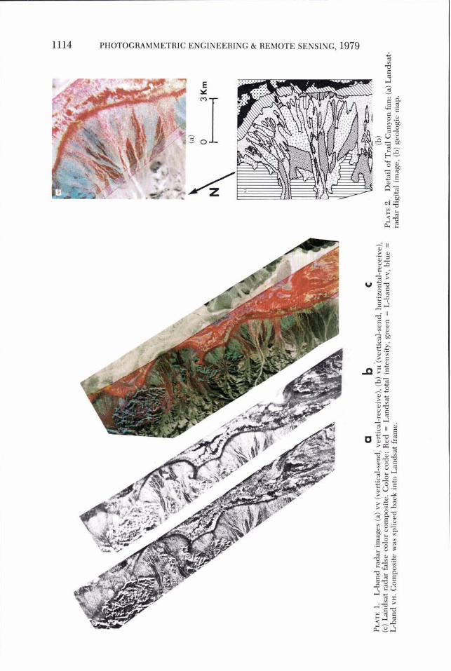
In the Landsat-radar false-color composite in Plate 1, details on the alluvial fans are more easily seen. Differences in some of the evaporite units on the salt pan are apparent. Stronger topographic effects are evident, though topography is still a problem and causes some local registration errors. Some effects of dual-polarization radar can be seen in the composite, especially in the salt pan.
The MSS can differentiate between alluvial fan surfaces with different desert varnish; however, it is insensitive to roughness dif- ferences that distinguish active surfaces from desert pavements. The L-band radar can easily discern desert pavements, but is blind to variations in desert varnish. There- fore, a Landsat-radar composite allows the mapping of the gravel units, defined by Hunt and Mabey (1966), which are charac- terized by the amount of desert varnish, gravel size, and topographic context.
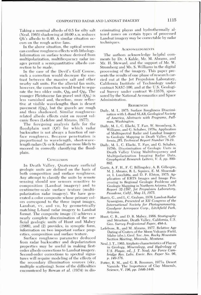
Trail Canyon fan is shown in detail in Plate 2a. Desert pavement areas are obvious as dark red elongated bodies extending radi- ally from the apex of the fan. These areas are shown on the enlargement of the geologic map of Hunt and Mabey (1966) (Plate 2b) as Qy, , the oldest gravel unit on the alluvial fans. They are dark red in the composite be- cause of the large amount of desert varnish and the very smooth desert pavement on these old surfaces. Some return, though, is apparent from the Landsat image.
The next oldest gravel unit is Qg, and is depicted on the composite as a light blue- green. This unit is dark with desert varnish but is rough to the L-band radar and there- fore bright.
The youngest gravel unit, Qg,, is light red or magenta in color indicating it is bright in all components. Because Qgg and Qg, appear the same in L-band imagery, the spatial res- olution of Landsat limits the resolution be- tween Qg, and Qg,.
Along the base of the fans is a band that appears very dark red. This indicates a re- turn from Landsat, but no return from L- band VH or vv polarizations. The L-band HH
polarization radar imagery of the area at the base of the fans has been studied by Schaber et al. (1976), who found a systematic de- crease in grain size toward the foot of the fans. This grain size decrease passed through the Rayleigh criterion for specular
reflection for L-band wavelengths at a fairly well-determined point in grain size, pro- ducing a dark band in imagery at the foot of the fans. The higher albedo in Landsat im- agery is the result of disintegration of rocks, leading to little desert varnish at the foot of the fans.
Flood deposits in the southern part of Badwater Basin exhibit polarization effects. The color composite shows this area as red and yellow. The like polarized L-band im- agery (vv) is bright, probably because of penetration effects. Landsat is bright be- cause of the salt crust that covers most of the flood deposits on the salt pan of Death Val- ley. The purer salts in the flood deposits are lighter than the salts of the massive rock salt unit (Qh). This albedo effect combined with roughness variations allows many details in the salt pan to be seen. In extremely rough terrains, passive reflection data (i.e., visible and near infrared) will be strongly modified by shadowing effects. Except for the special case of imaging at local noon at the solar equator, two effects exist: (1) Overall de- crease in albedo because of shadowing ef- fects, and (2 ) Spectral shifts generated by the contribution of those areas in shadow that are illuminated by sources having spectral properties different from direct sunlight (sky, multiple reflections from surface). Evaluation of this effect would involve
Multiple imaging at different times of day. This option is not possible for rotation- synchronous platforms (e.g., Landsat). Imaging by a sensor that is sensitive to roughness. Knowledge of both the local sun angle and roughness properties of the surface will permit a semiquantitative al- bedo correction to be made. Use of atmospheric scattering model to correct for differential effects as a function of xx.
As an example, the surface of the Devil's Golf Course (Qh) consists of steep-sided tow- ers and cavities having local slopes ranging from 45 to 90 degrees. The Landsat image, acquired at a sun angle of 48 degrees shows Qh as a distinctly darker unit than adjacent Qf (flood-plain deposits). Field measure- ment of shadows for a sun angle of 50 de- grees show
Shadow brightness (estimated from a cam- era light meter) is less than 10 percent of the reflectivity of a fully illuminated por- tion of the silty salt. Approximately 20 percent of the surface as seen from above is in shadow.
Taking the albedo of the shadows to be zero, the calculated effect of shadowing is a reduction of the albedo of Qh by 20 percent.
PHOTOGRAMMETRIC ENGINEERING & REMOTE SENSING, 1979
COMPOSITED RADAR AND LANDSAT IMAGERY
Taking a nominal albedo of 0.5 for silty salt (Neal, 1965) shadowing at 10:OO A.M. reduces Qh's albedo to 0.40. A similar situation oc- curs on the rough active fans.
In the above situation, the optical sensors can confuse roughness effects with lithology. Information on surface texture derived from multipolarization, multifrequency radar im- ages permit a semiquantitative albedo cor- rection to be made.
In the case of the Devil's Golf Course, such a correction would decrease the con- trast between the massive salt and other nearby salt units. For the alluvial fan units, however, the correction would tend to sepa- rate the two older units, Qg, and Qg,. The younger Pleistocene fan gravel unit (Qg,) is less varnished and, therefore, more reflec- tive at visible wavelengths than is desert pavement (Qg,), but the gravels are rough and thus shadowed. Similar roughness- related albedo effects exist on recent vol- canic flows (Lefebre and Abrams, 1977).
T h e foregoing analysis fails for t h e f loodplain uni t (Qf ) for which radar backscatter is not always a function of sur- face roughness. Because penetration is proportional to wavelength, short-wave- length radars (X- or K-band) are more likely to succeed in correctly classifying the flood- plain.
I n Death Valley, Quaternary surficial geologic units are defined on the basis of both composition and surface roughness. Any attempt to classify the units by remote sensing should use sensors sensitive to composit ion (Landsat imagery) a n d to centimetre-scale surface texture (multi- polarization radar imagery). We have gen- erated a color composite whose primary col- ors correspond to the three input images, Landsat , vv, a n d VH, by geometrically matching L-band radar imagery to Landsat format. The composite image (1) achieves a nearly complete discrimination of the sur- ficial geologic units of Hunt and Mabey (1966), and (2) provides, in synoptic form, information on two important surface prop- erties, composition and surface texture.
Surface roughness parameter deduced from radar backscatter and depolarization properties may be useful in making first- order albedo corrections to Landsat imagery. Second-order corrections to spectral signa- tures will require modeling of the effects of the secondary illumination sources (sky, multiple scattering). Some of the difficulties encountered by Rowan et al. (1974) in dis-
criminating playas and hydrothermally al- tered zones on certain types of processed Landsat imagery may be correctable by radar techniques.
The authors acknowledge helpful com- ments by Dr. A Kahle, Mr. M. Abrams, and Mr. H. Steward, and the support of Mr. W. Stromberg and Ms. S. Williams in the digital processing of the imagery. This paper pre- sents the results of one phase of research car- ried out at the Jet Propulsion Laboratory, California Institute of Technology under contract NAS7-100, and at the U.S. Geologi- cal Survey under contract W-13576, spon- sored by the National Aeronautics and Space Administration.
REFERENCES Daily, M. I., 1975. Surface Roughness Discrimi-
nation with L-Band SLAR, Geo2ogical Society of America, Abstracts with Programs, Pull- man, Washington.
Daily, M. I., C. Elachi, T. Farr, W. Stromberg, S. Williams, and G. Schaber, 1978a. Application of M~ltis~ectral Radar and Landsat Imagery to Geologic Mapping in Death Valley, Cali- fornia, JPL Technical Report Number 78-19.
Daily, M. I., C. Elachi, T. Farr, and G. Schaber, 1978b. Discrimination of Geologic Units in Death Valley Using Multifrequency and Multipolarization Imaging Radar Data, Geophysical Research Letters, V . 5, pp. 889- 892.
Goetz, A. F. H., F. C. Billingsley, A. R. Gillespie, M. J. Abrams, R. L. Squires, E. M. Shoemak- er, I. Lucchitta, and D. P. Elston, 1975. Ap- plication of ERTS Images and Image Pro- cessing to Regional Geologic Problems and Geologic Mapping in Northern Arizona. Tech. Report 32-1597, Jet Propulsion Laboratow, Pasadena, Calif., May 15, 1975.
Harris, G., and L. C. Graham, 1976. Landsat-Radar Synergism, Presented at XI1 Congress of the International Society for Photogrammetry, Goodyear Aerospace Corp., Litchfield Park, Arizona.
Hunt, C. B., and D. R. Mabey, 1966. Stratigraphy and Structure, Death Valley, California, U.S. Geo. Survey Professional Paper, 494-A.
Lefebvre, R., and M. Abrams, 1977. Relative Age Dating of Craters of the Moon Volcanic Field, Idaho (abs.); Geol. Soc. Am. Rocky Mountain Section Meeting, Missoula, Montana.
Neal, J. T., 1965. Airphoto characteristics of Playas, in Geology, Mineralogy, and Hydrology of U.S. Playas, ed., J . T . Neal; Air Force Cam- bridge Res. Labs. Envir. Res. Paper No. 96, p. 149-176.
Potter, R. M., and G. R. Rossman, 1977a. Desert Varnish: The Importance of Clay Minerals, Science, V. 196, pp. 1446-1448.
PHOTOGRAMMETRIC ENGINEERING & REMOTE SENSING, 1979
, 1977b. Desert Varnish: Mineralogy of the Ferro-Manganese Oxides, Abstract in Proceedings of Amer. Geophysical Union, Fall 1977.
Rowan, L. C., P. H. Wetlaufer, A. F. H. Goetz, F. C. Billingsley, and J. H. Stewart, 1974. Discrimination of Rock Types and Detection of Hydrothermally Altered Areas in South- Central Nevada, U.S. Geological Survey Professional Paper 883,35 pp.
Schaber, G. G., G. L. Berlin, and W. E. Brown, Jr., 1976. Variations in Surface Roughness within Death Valley, California: Geologic
Evaluation of 25-cm Wavelength Radar Images, Geol. Soc, of Amer. Bulletin, V . 87, pp. 29-41.
Siegal, B. S., and A. F. H. Goetz, 1977. Effect of Vegetation on Rock and Soil type discrimina- tion, Photogrammetric Eng. and Remote Sensing, 43, 191-1 96.
Valenzuela, G., 1968. Scattering of Electromag- netic Waves from a Tilted Slightly Rough Surface, Radio Science, 1, 1057-1 066.
(Received May 2, 1978; revised and accepted April 23, 1979)
Call for Papers
Specialty Conference on Civil Engineering Applications of Remote Sensing
The University of Wisconsin Madison, Wisconsin August 13-1 4, 1980
This conference, sponsored by the Aerospace Division and Surveying and Mapping Division of the American Society of Civil Engineers and by the American Society of Photo- grammetry, is inviting papers on the practical applications of remote sensing in civil engi- neering practice. Papers dealing with aerial photography, thermal and multispectral scan- ning, radar, passive microwave, and remote sensing from Earth orbit are appropriate. Half- day sessions are planned covering the following application areas:
water resources applications geotechnical applications environmental assessment general civil engineering applications
Presentation time for each paper will be 20 minutes. Authors of papers accepted for presentation will be expected to submit camera-ready copy of their papers by May 1, 1980 for inclusion in the Conference Proceedings.
Proposals must include the following:
Title of proposed paper Author's name, address, telephone number, and position One-page summary of the paper's technical content
In order for papers to be considered for inclusion in the program, proposals must be received not later than October 15, 1979. Please submit proposals to
Prof. Ralph W. Kiefer, Chairman Conference Program Committee 1210 Engineering Building The University of Wisconsin-Madison Madison, WI 53706