Embed Size (px)
Citation preview
1
Geolocation Accuracy Re-Evaluations of GeoEye-1 and QuickBird-2
Paul C. Bresnahan
Contractor, NGA Image Quality and Utility Program
2012 JACIE Workshop
18 April 2012
1
Approved for Public Release 12-182
2
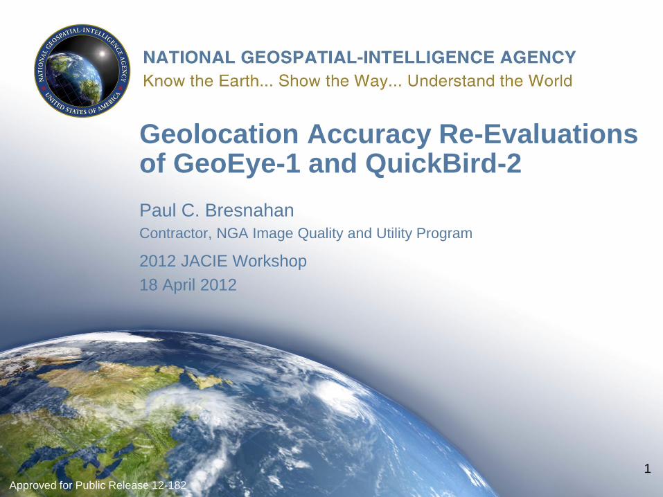
Methodology
• Photogrammetric software provides NIQU/CCAP
capability to use physical sensor or geometry models
with imagery
• Turn photogrammetric software on its head
– “Direct Geopositioning” assessment
– Instead of resecting or triangulating images to ground control
points (GCPs), we fix image support data and allow copy of
GCPs to move to the image or stereo pair
– “Copy of GCPs” are Check Points (CPs)
• End product accuracy assessments
– No correction for off-nadir angle
Approved for Public Release 12-182
3
Definitions of Statistics
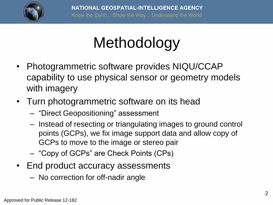
• Sample Circular Error 90% (CE90) – In horizontal plane
– Radial error distance centered at zero within which 90% of the data points fall
• Sample Linear Error 90% (LE90) – In vertical dimension
– Absolute value error distance from zero within which 90% of the vertical data points fall
Approved for Public Release 12-182
4
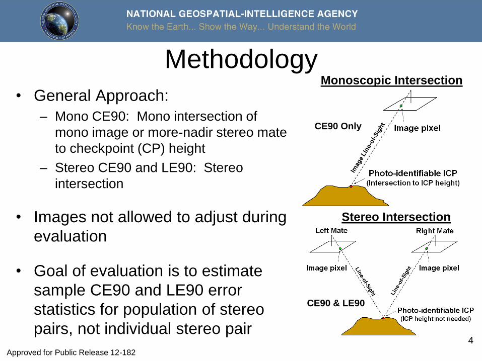
Methodology
• General Approach:
– Mono CE90: Mono intersection of
mono image or more-nadir stereo mate
to checkpoint (CP) height
– Stereo CE90 and LE90: Stereo
intersection
• Images not allowed to adjust during
evaluation
• Goal of evaluation is to estimate
sample CE90 and LE90 error
statistics for population of stereo
pairs, not individual stereo pair
Monoscopic Intersection
Stereo Intersection
CE90 Only
CE90 & LE90
Approved for Public Release 12-182
5
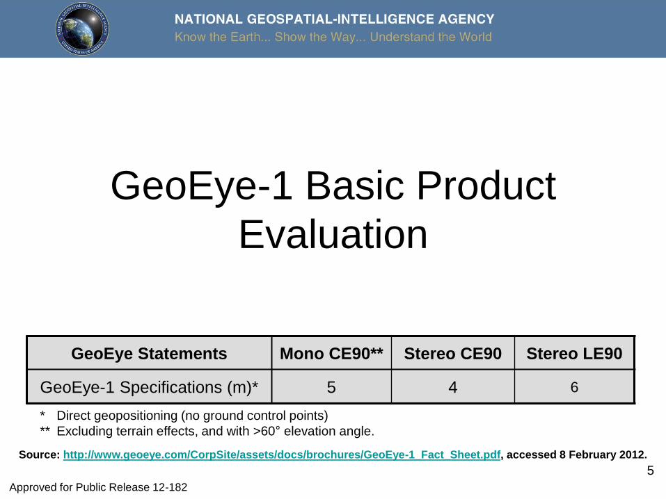
GeoEye-1 Basic Product
Evaluation
GeoEye Statements Mono CE90** Stereo CE90 Stereo LE90
GeoEye-1 Specifications (m)* 5 4 6
* Direct geopositioning (no ground control points)
** Excluding terrain effects, and with >60° elevation angle.
Source: http://www.geoeye.com/CorpSite/assets/docs/brochures/GeoEye-1_Fact_Sheet.pdf, accessed 8 February 2012.
Approved for Public Release 12-182
6
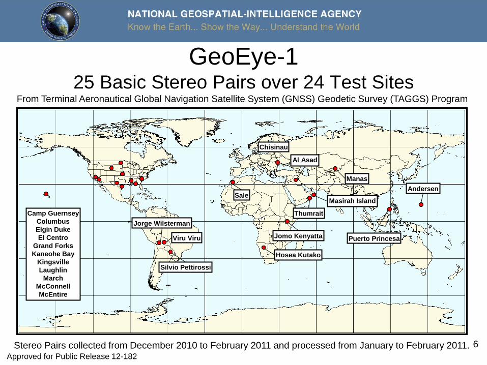
GeoEye-1 25 Basic Stereo Pairs over 24 Test Sites
Stereo Pairs collected from December 2010 to February 2011 and processed from January to February 2011.
From Terminal Aeronautical Global Navigation Satellite System (GNSS) Geodetic Survey (TAGGS) Program
Hosea Kutako
Al Asad
Manas
Silvio Pettirossi
Camp Guernsey
Columbus
Elgin Duke
El Centro
Grand Forks
Kaneohe Bay
Kingsville
Laughlin
March
McConnell
McEntire
Puerto Princesa
Andersen Sale
Viru Viru
Jorge Wilsterman
Chisinau
Jomo Kenyatta
Masirah Island
Thumrait
Approved for Public Release 12-182
7
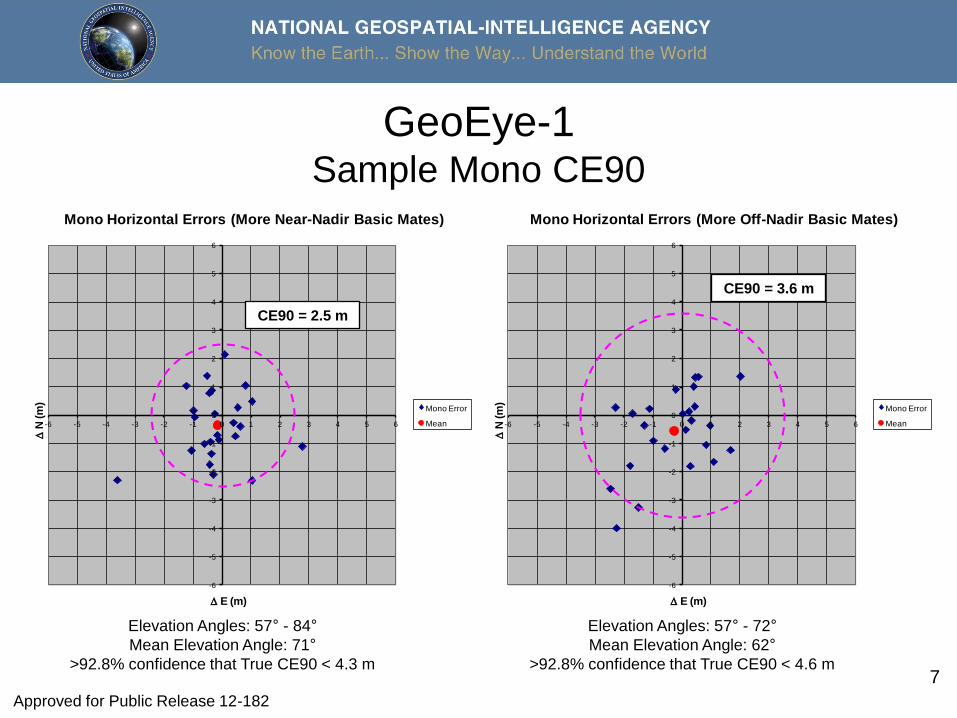
GeoEye-1 Sample Mono CE90
-6
-5
-4
-3
-2
-1
0
1
2
3
4
5
6
-6 -5 -4 -3 -2 -1 0 1 2 3 4 5 6
DN
(m
)
D E (m)
Mono Horizontal Errors (More Off-Nadir Basic Mates)
Mono Error
Mean
CE90 = 3.6 m
-6
-5
-4
-3
-2
-1
0
1
2
3
4
5
6
-6 -5 -4 -3 -2 -1 0 1 2 3 4 5 6
DN
(m
)
D E (m)
Mono Horizontal Errors (More Near-Nadir Basic Mates)
Mono Error
Mean
CE90 = 2.5 m
Elevation Angles: 57° - 84°
Mean Elevation Angle: 71°
>92.8% confidence that True CE90 < 4.3 m
Elevation Angles: 57° - 72°
Mean Elevation Angle: 62°
>92.8% confidence that True CE90 < 4.6 m
CE90 = 2.5 m
CE90 = 3.6 m
Approved for Public Release 12-182
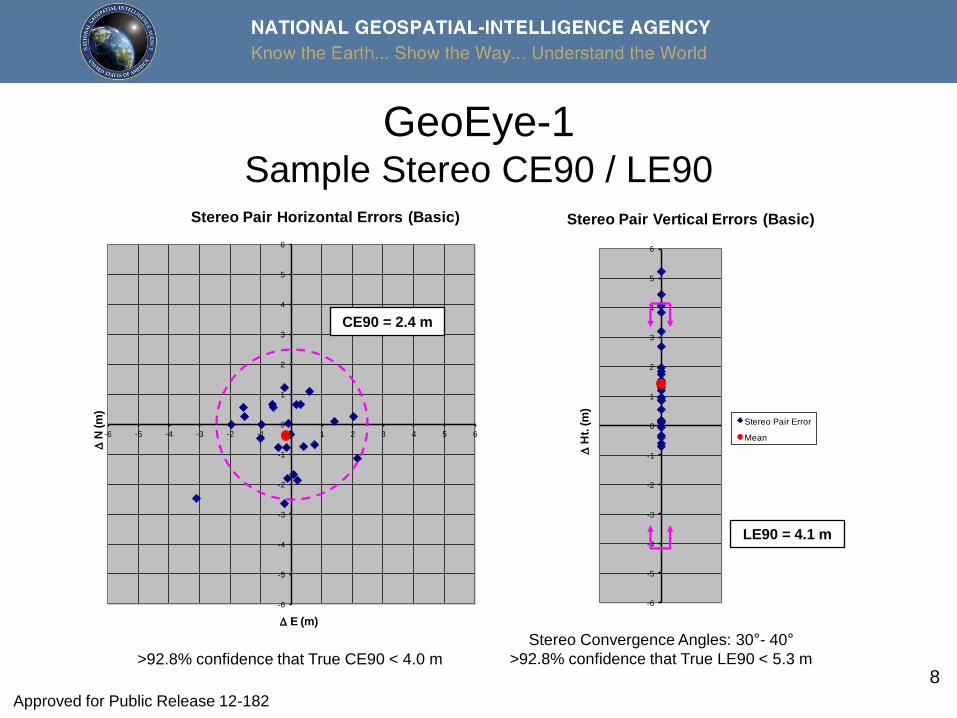
8
GeoEye-1 Sample Stereo CE90 / LE90
-6
-5
-4
-3
-2
-1
0
1
2
3
4
5
6
-6 -5 -4 -3 -2 -1 0 1 2 3 4 5 6
DN
(m
)
D E (m)
Stereo Pair Horizontal Errors (Basic)
Stereo Pair Error
Mean
CE90 = 2.4 m
-6
-5
-4
-3
-2
-1
0
1
2
3
4
5
6
DH
t. (
m)
Stereo Pair Vertical Errors (Basic)
Stereo Pair Error
Mean
LE90 = 4.1 m
Stereo Convergence Angles: 30°- 40°
>92.8% confidence that True LE90 < 5.3 m >92.8% confidence that True CE90 < 4.0 m
CE90 = 2.4 m
LE90 = 4.1 m
Approved for Public Release 12-182
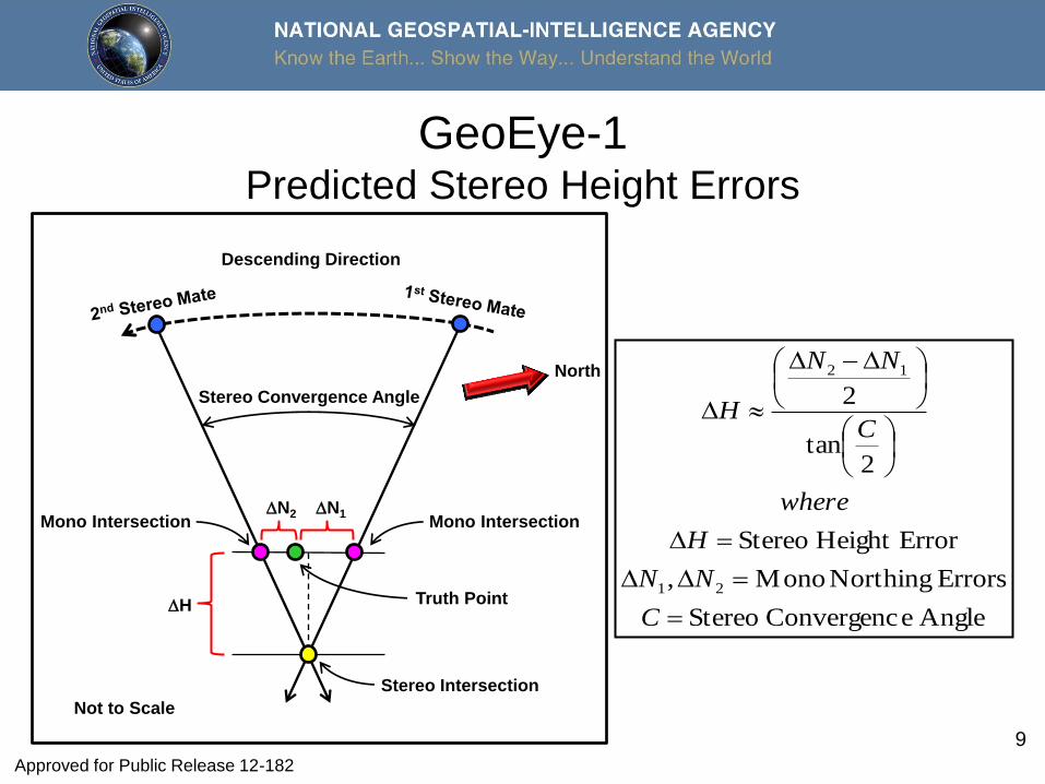
9
GeoEye-1 Predicted Stereo Height Errors
Mono Intersection
Stereo Intersection
Truth Point
Mono Intersection DN1 DN2
DH
Stereo Convergence Angle
North
Not to Scale
Descending Direction
Angle eConvergenc Stereo
Errors Northing Mono,
ErrorHeight Stereo
2tan
2
21
12
DD
D
DD
D
C
NN
H
where
C
NN
H
Approved for Public Release 12-182

10
GeoEye-1 Stereo Mates Northing Errors; Sorted by Abs. Ht. Error
-6
-5
-4
-3
-2
-1
0
1
2
3
4
5
6
DN
(m
)
Stereo Mate Comparison - DN
(Sorted by Absolute Height Error-Ascending to Right)
1st Mates-Delta N
2nd Mates-Delta N
Approved for Public Release 12-182
11
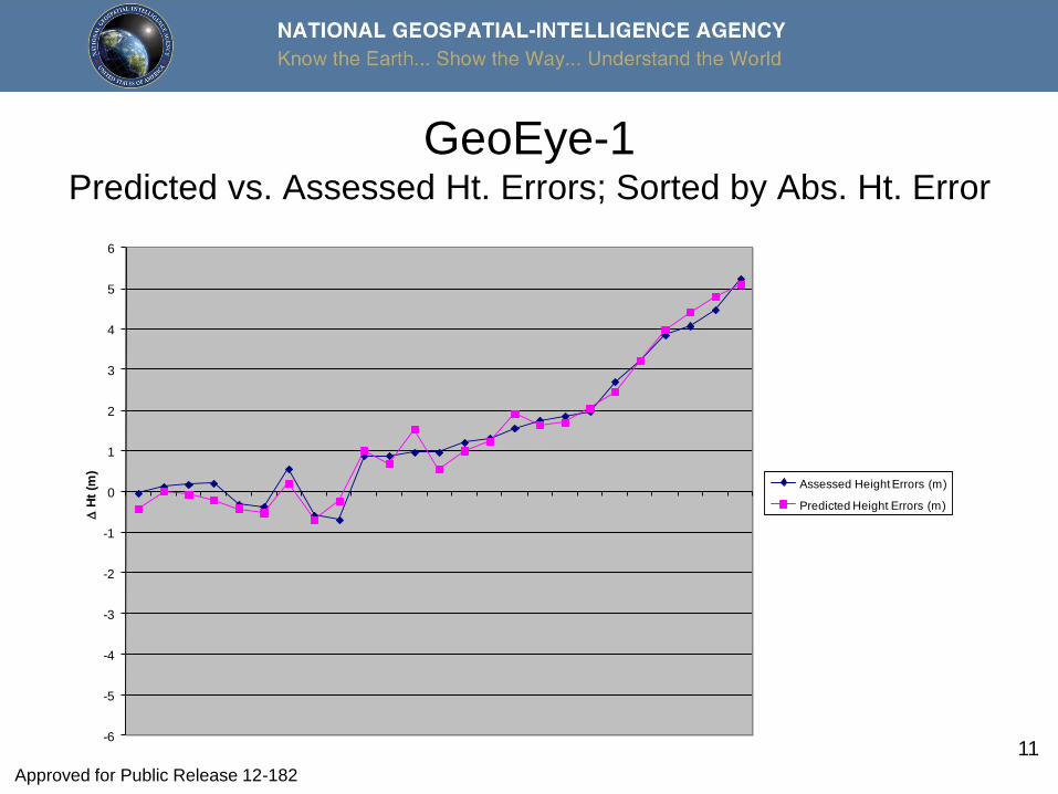
GeoEye-1 Predicted vs. Assessed Ht. Errors; Sorted by Abs. Ht. Error
-6
-5
-4
-3
-2
-1
0
1
2
3
4
5
6
DH
t (m
)
Stereo Mate Comparison - DHeight
(Sorted by Absolute Height Error-Ascending to Right)
Assessed Height Errors (m)
Predicted Height Errors (m)
Approved for Public Release 12-182
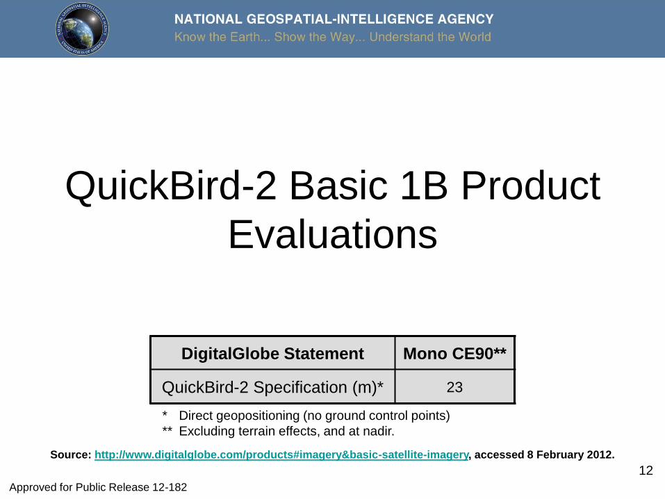
12
QuickBird-2 Basic 1B Product
Evaluations
DigitalGlobe Statement Mono CE90**
QuickBird-2 Specification (m)* 23
* Direct geopositioning (no ground control points)
** Excluding terrain effects, and at nadir.
Source: http://www.digitalglobe.com/products#imagery&basic-satellite-imagery, accessed 8 February 2012.
Approved for Public Release 12-182
13
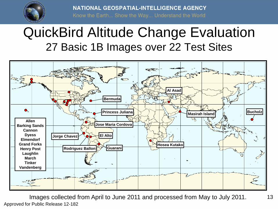
QuickBird Altitude Change Evaluation 27 Basic 1B Images over 22 Test Sites
Images collected from April to June 2011 and processed from May to July 2011.
Hosea Kutako
Al Asad
Allen
Barking Sands
Cannon
Dyess
Elmendorf
Grand Forks
Henry Post
Laughlin
March
Tinker
Vandenberg
Masirah Island
Bermuda
El Alto
Bucholz Princess Juliana
Jorge Chavez
Rodriguez Ballon
Jose Maria Cordova
Guarani
Approved for Public Release 12-182
14
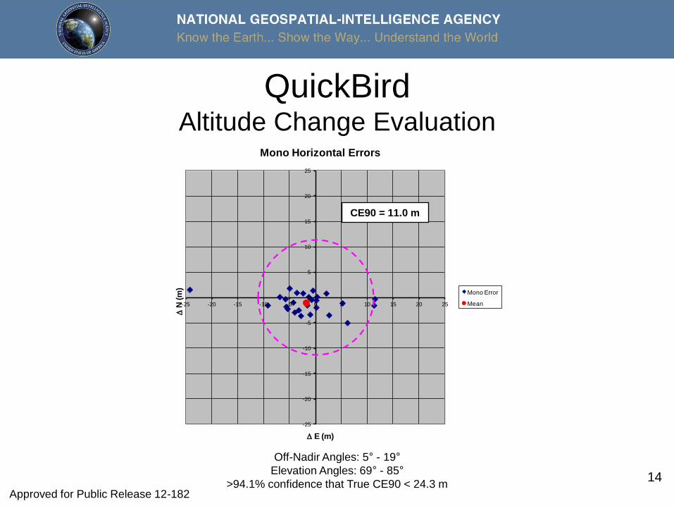
QuickBird Altitude Change Evaluation
-25
-20
-15
-10
-5
0
5
10
15
20
25
-25 -20 -15 -10 -5 0 5 10 15 20 25
DN
(m
)
D E (m)
Mono Horizontal Errors
Mono Error
Mean
CE90 = 11.0 m
Off-Nadir Angles: 5° - 19°
Elevation Angles: 69° - 85°
>94.1% confidence that True CE90 < 24.3 m
CE90 = 11.0 m
Approved for Public Release 12-182
15
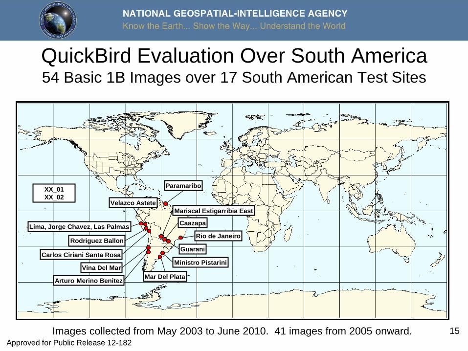
QuickBird Evaluation Over South America 54 Basic 1B Images over 17 South American Test Sites
XX_01
XX_02
Paramaribo
Lima, Jorge Chavez, Las Palmas
Rodriguez Ballon
Guarani
Rio de Janeiro
Mar Del Plata
Ministro Pistarini
Arturo Merino Benitez
Vina Del Mar
Caazapa
Mariscal Estigarribia East
Carlos Ciriani Santa Rosa
Velazco Astete
Images collected from May 2003 to June 2010. 41 images from 2005 onward. Approved for Public Release 12-182
16
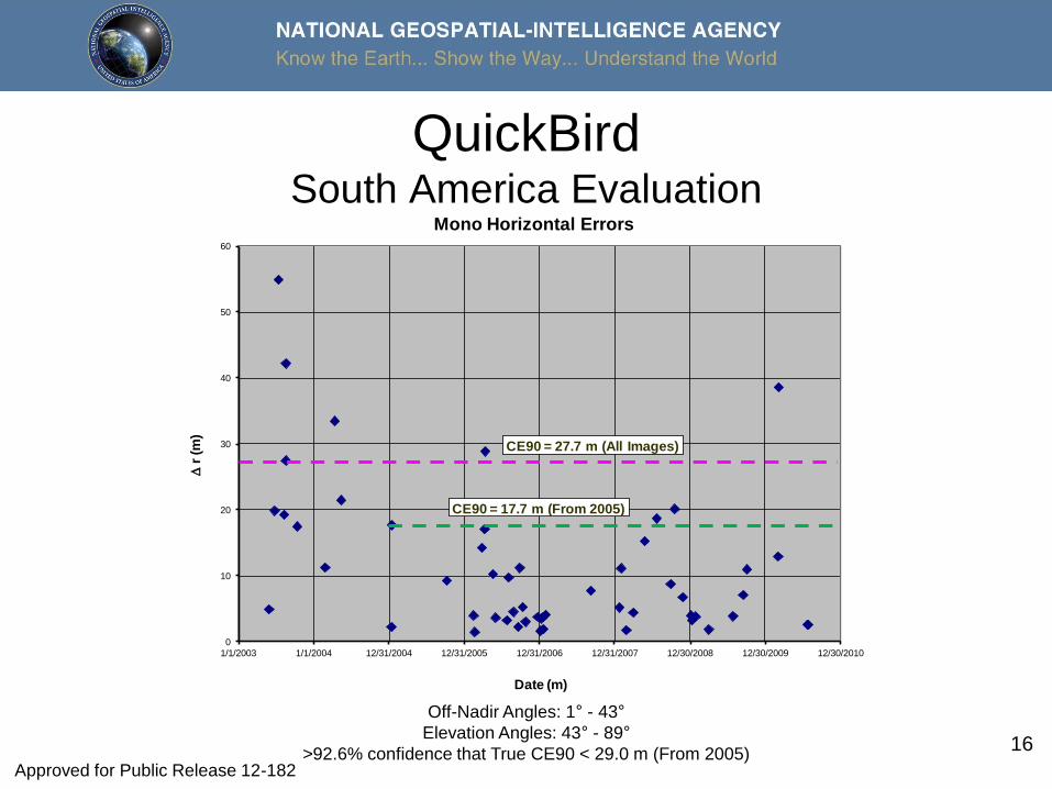
QuickBird South America Evaluation
0
10
20
30
40
50
60
1/1/2003 1/1/2004 12/31/2004 12/31/2005 12/31/2006 12/31/2007 12/30/2008 12/30/2009 12/30/2010
Dr
(m)
Date (m)
Mono Horizontal Errors
CE90 = 27.7 m (All Images)
CE90 = 17.7 m (From 2005)
Off-Nadir Angles: 1° - 43°
Elevation Angles: 43° - 89°
>92.6% confidence that True CE90 < 29.0 m (From 2005) Approved for Public Release 12-182
17
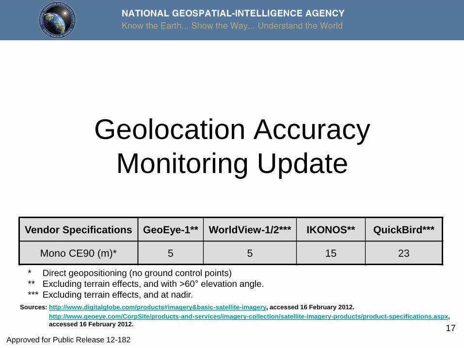
Geolocation Accuracy
Monitoring Update
Vendor Specifications GeoEye-1** WorldView-1/2*** IKONOS** QuickBird***
Mono CE90 (m)* 5 5 15 23
* Direct geopositioning (no ground control points)
** Excluding terrain effects, and with >60° elevation angle.
*** Excluding terrain effects, and at nadir.
Sources: http://www.digitalglobe.com/products#imagery&basic-satellite-imagery, accessed 16 February 2012.
http://www.geoeye.com/CorpSite/products-and-services/imagery-collection/satellite-imagery-products/product-specifications.aspx,
accessed 16 February 2012.
Approved for Public Release 12-182
18
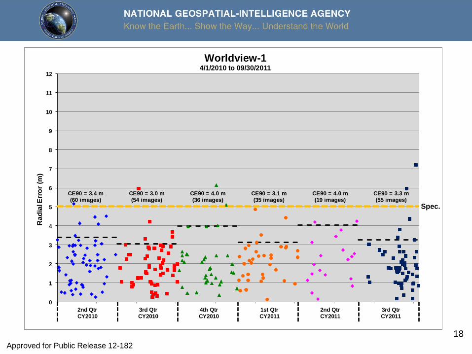
0
1
2
3
4
5
6
7
8
9
10
11
12
Ra
dia
l Err
or
(m)
Worldview-14/1/2010 to 09/30/2011
CE90 = 3.4 m(60 images)
CE90 = 3.3 m(55 images)
CE90 = 4.0 m(19 images)
CE90 = 4.0 m(36 images)
CE90 = 3.0 m(54 images)
CE90 = 3.1 m(35 images)
2nd QtrCY2010
3rd QtrCY2010
4th QtrCY2010
1st QtrCY2011
2nd QtrCY2011
3rd QtrCY2011
Spec.
Approved for Public Release 12-182
19
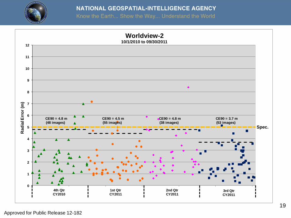
0
1
2
3
4
5
6
7
8
9
10
11
12
Ra
dia
l Err
or
(m)
Worldview-210/1/2010 to 09/30/2011
CE90 = 4.5 m(55 images)
CE90 = 4.8 m(38 images)
CE90 = 3.7 m(53 images)
CE90 = 4.8 m(48 images)
4th QtrCY2010
1st QtrCY2011
2nd QtrCY2011
3rd QtrCY2011
Spec.
Approved for Public Release 12-182
20
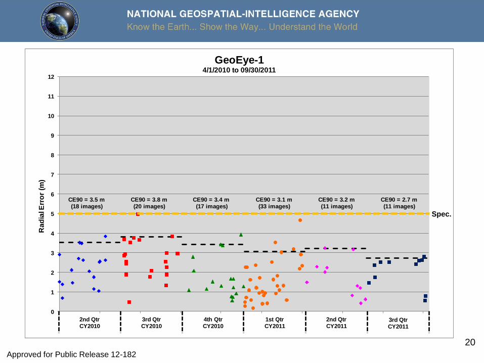
0
1
2
3
4
5
6
7
8
9
10
11
12
Ra
dia
l Err
or
(m)
GeoEye-14/1/2010 to 09/30/2011
CE90 = 3.1 m(33 images)
CE90 = 3.2 m(11 images)
CE90 = 2.7 m(11 images)
CE90 = 3.5 m(18 images)
CE90 = 3.8 m(20 images)
CE90 = 3.4 m(17 images)
2nd QtrCY2010
3rd QtrCY2010
4th QtrCY2010
1st QtrCY2011
2nd QtrCY2011
3rd QtrCY2011
Spec.
Approved for Public Release 12-182
21
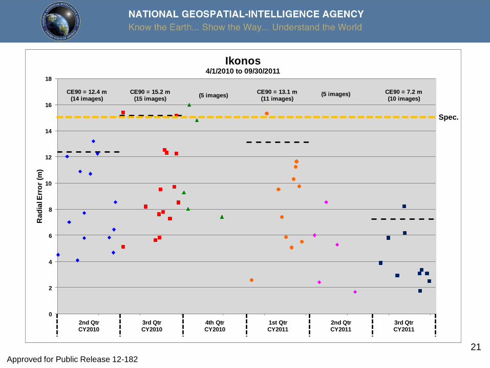
0
2
4
6
8
10
12
14
16
18
Ra
dia
l Err
or
(m)
Ikonos4/1/2010 to 09/30/2011
(5 images)(5 images)CE90 = 15.2 m
(15 images)CE90 = 12.4 m
(14 images)CE90 = 7.2 m(10 images)
CE90 = 13.1 m(11 images)
2nd QtrCY2010
3rd QtrCY2010
4th QtrCY2010
1st QtrCY2011
2nd QtrCY2011
3rd QtrCY2011
Spec.
Approved for Public Release 12-182
22
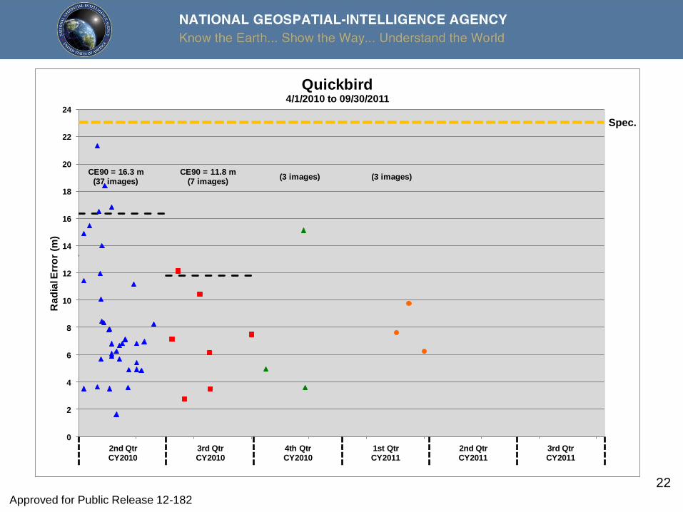
0
2
4
6
8
10
12
14
16
18
20
22
24
Ra
dia
l Err
or
(m)
Quickbird4/1/2010 to 09/30/2011
CE90 = 11.8 m(7 images)
CE90 = 16.3 m(37 images)
(3 images) (3 images)
2nd QtrCY2010
3rd QtrCY2010
4th QtrCY2010
1st QtrCY2011
2nd QtrCY2011
3rd QtrCY2011
Spec.
Approved for Public Release 12-182
23
Summary
• With two minor exceptions, imagery within vendor-stated
geolocation accuracy specifications
– Early QuickBird-2 images over South America
– CY2010 Qtr3 IKONOS: CE90 estimate slightly above
specification but sample size of only 15 images and uncertainty
of estimate straddles the specification line
• Minimal impact for both cases
Approved for Public Release 12-182