Embed Size (px)
Citation preview
BERLAND RESOURCES LTD.
SWOLE LAKE PROPERTY
ONTARIO
NTS 42L/5
2.22420
GEOLOGICAL and PROSPECTING REPORT
O H O
a o
ow
01
SUBMITTED BY:
WILLIAM MCCRINDLE, P. ENG.
November, 2001
\n o
TABLE OF CONTENTS
INTRODUCTION . . . . . . . . . . . . . . . . . . . . . . . . . . . . . . . . . . . . . . . . . . . . . . . . . . . . . . . . . . . . . 3
LOCATION and ACCESSIBILITY . . . . . . . . . . . . . . . . . . . . . . . . . . . . . . . . . . . . . . . . . . . . . . . . . . . . . 3
PROPERTY DESCRIPTION . . . . . . . . . . . . . . . . . . . . . . . . . . . . . . . . . . . . . . . . . . . . . . . . . . . . . . . . . . 3
CLAIM LIST (table #1) . . . . . . . . . . . . . . . . . . . . . . . . . . . . . . . . . . . . . . . . . . . . . . . . . . . . . . . . . . . . . . . 6
HISTORY . . . . . . . . . . . . . . . . . . . . . . . . . . . . . . . . . . . . . . . . . . . . . . . . . . . . . . . . . . . . . . . . . . . . . . . . . 6
GEOLOGICAL SETTING . . . . . . . . . . . . . . . . . . . . . . . . . . . . . . . . . . . . . . . . . . . . . . . . . . . . . . . . . . . . 6
DEPOSIT TYPES . . . . . . . . . . . . . . . . . . . . . . . . . . . . . . . . . . . . . . . . . . . . . . . . . . . . . . . . . . . . . . . . . . . 7
GEOLOGICAL PROSPECTING AND MAPPING . . . . . . . . . . . . . . . . . . . . . . . . . . . . . . . . . . . . . . . . . 7
MINERALIZATION . . . . . . . . . . . . . . . . . . . . . . . . . . . . . . . . . . . . . . . . . . . . . . . . . . . . . . . . . . . . . . . . . 9
Table #2 Sample Locations, Assays, Base and Precious Metals 9
Table #3 Pegmatite Samples - Selected Assay Results (table #4) 10
PROSPECTING . . . . . . . . . . . . . . . . . . . . . . . . . . . . . . . . . . . . . . . . . . . . . . . . . . . . . . . . . . . . . . . . . . . . 10
FIELD PERSONNEL ...............................................................11
CONCLUSIONS AND RECOMMENDATIONS . . . . . . . . . . . . . . . . . . . . . . . . . . . . . . . . . . . . . . . . . . 12
CERTIFICATE OF QUALIFIED PERSON . . . . . . . . . . . . . . . . . . . . . . . . . . . . . . . . . . . . . . . . . . . . . . 13
Figures:1. Property Location 4
2. Claim Disposition 5
3. Geological Map Pocket
Appendix I PhotosAppendix II Accurassay Assay Certificate of AnalysisAppendix III XRAL Labs Assay Certificate of Analysis
-2-
INTRODUCTION
In September of 2001, Berland Resources Ltd. signed a letter agreement with Ninety Nine Resources Ltd. of Thunder Bay, Ontario to option the 7 claim (3 separate claim groups) property with nickel, copper and platinum group element potential. Berland can earn a 10007o interest subject to certain net smelter royalties by making cash and share payments over three years.
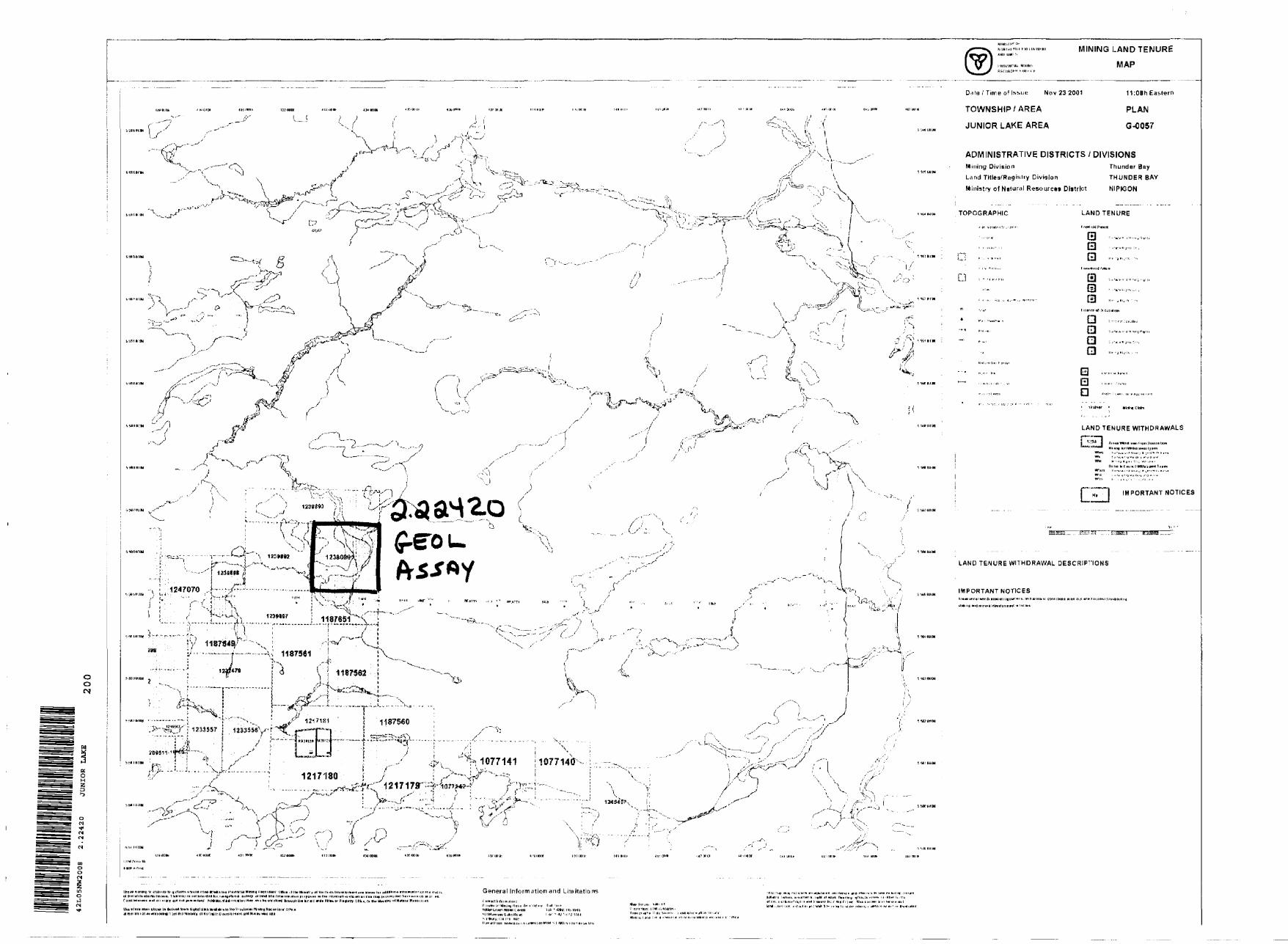
Claim 1247070 was recorded on October 5, 2001 to link together the two eastern blocks. The property now consists of 8 unpatented mining claims, 99 units and covers 3,960 acres in two separate blocks located in the Junior lake (G-57) and Falcon Lake (G-35) claim map areas of the Thunder Bay mining Division. All work described in this report was conducted on the east block and specifically on claim 123 8090.
In October of 2001, Berland contracted M. P. Lewis Geological Services of Thunder Bay, Ontario to conduct a geological survey on the cut grid on the Swole Lake property. Mr. Pat Lewis (P. Geo) mapped the grid and wrote the geological mapping and prospecting portion of this report. Stares Contracting Corporation of Thunder Bay, Ontario was contracted by Berland Resources Ltd. to prospect the grid at the same time. The logistics and results are reported in the attached report prepared by W. Mccrindle of Berland.
LOCATION AND ACCESSIBILITY
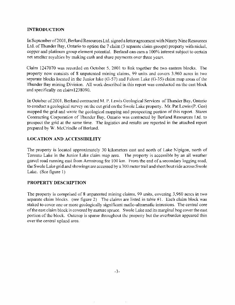
The property is located approximately 30 kilometers east and north of Lake Nipigon, north of Toronto Lake in the Junior Lake claim map area. The property is accessible by an all weather gravel road running east from Armstrong for 100 km. From the end of a secondary logging road, the Swole Lake grid and showings are accessed by a 300 meter trail and short boat ride across Swole Lake. (See figure 1)
PROPERTY DESCRIPTION
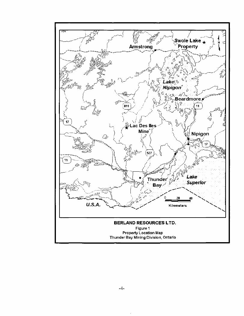
The property is comprised of 8 unpatented mining claims, 99 units, covering 3,960 acres in two separate claim blocks, (see figure 2) The claims are listed in table #1. Each claim block was staked to cover one or more geologically significant mafic-ultramafic intrusions. The central core of the east claim block is covered by mature spruce. Swole Lake and its marginal bog cover the east portion of the block. Outcrop is sparse throughout the property but the overburden appeared thin over the central upland area.
-3-
( ,Swole Lake^Property
BERLAND RESOURCES LTD.Figure 1
Property Location Map Thunder Bay Mining Division, Ontario
-4-
1 NLU OOOS8S9 |
420000 mE 430000 mE
1
j
J ,™—~-~-'"
tfr
X4239925
(,
0
kik
,/
/' Falcon /' Lake ^{
j^-~ \., — ~ :"~"
j (V --"1— --. -.----. ....-^-..L. ---^
t.--~~™™~
-^
v] ^x^
North Larnaune Lake
\
^——— -K^metersi ,) — —,ji /v
^^,^^.'•x
^^-V---'"""r---
^ ^.\ /' -^ \\ -^ j"1 ^--....x i -•-'''
/' ^
\ -^''' -':~"~' \ —— - — ?r*\ iz" — '~i jcriinri~i A
IWoTj
-,
— --.. x'' \ Tape
1 Lake ^'
f
i f
1239893
39898 ^ils ")
1239892 ^^^ ) ^1231150.
1239897 0 , S wo l eLake
Claim Map Swole Lake Property Figure 2
"\
i'
x
f
420000 mE 430000 mE
\ 5585000 mN |
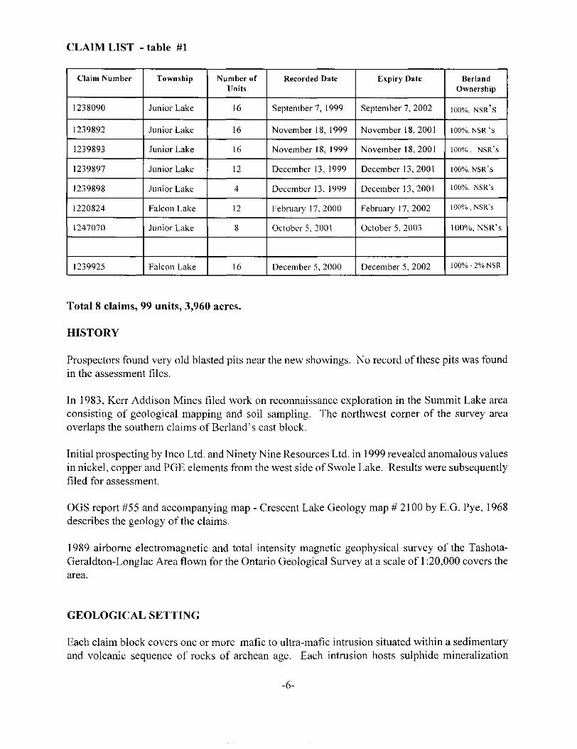
CLAIM LIST - table #1
Claim Number
1238090
1239892
1239893
1239897
1239898
1220824
1247070
1239925
Township
Junior Lake
Junior Lake
Junior Lake
Junior Lake
Junior Lake
Falcon Lake
Junior Lake
Falcon Lake
Number of Units
16
16
16
12
4
12
8
16
Recorded Date
September 7, 1 999
November 18, 1999
November 18, 1999
December 13, 1999
December 13, 1999
February 17,2000
October 5, 2001
December 5, 2000
Expiry Date
September 7, 2002
November 18,2001
November 18,2001
December 13,2001
December 13,2001
February 1 7, 2002
October 5, 2003
December 5, 2002
Berland Ownership
ioooXo, NSR'S
1000Xo, NSR's
ioooXo, NSR'S
iooox0 . NSR'S
1000X0, NSR's
1000Xo, NSR's
1000Xo, NSR's
1000Xo-20XoNSR
Total 8 claims, 99 units, 3,960 acres.
HISTORY
Prospectors found very old blasted pits near the new showings. No record of these pits was found in the assessment files.
In 1983, Kerr Addison Mines filed work on reconnaissance exploration in the Summit Lake area consisting of geological mapping and soil sampling. The northwest corner of the survey area overlaps the southern claims of Berland's east block.
Initial prospecting by Inco Ltd. and Ninety Nine Resources Ltd. in 1999 revealed anomalous values in nickel, copper and PGE elements from the west side of Swole Lake. Results were subsequently filed for assessment.
OGS report #55 and accompanying map - Crescent Lake Geology map # 2100 by E.G. Pye, 1968 describes the geology of the claims.
1989 airborne electromagnetic and total intensity magnetic geophysical survey of the Tashota- Geraldton-Longlac Area flown for the Ontario Geological Survey at a scale of l :20,000 covers the area.
GEOLOGICAL SETTING
Each claim block covers one or more mafic to ultra-mafic intrusion situated within a sedimentary and volcanic sequence of rocks of archean age. Each intrusion hosts sulphide mineralization
-6-
containing anomalous values in nickel, copper and PGE's or untested airborne geophysical electromagnetic anomalies detected by a recent OGS airborne geophysical survey. With the discovery of pegmatite boulders, the proximity of the granitic pluton to the north becomes of great significance.
DEPOSIT TYPES
The primary focus of the exploration is to locate a gabbroic intrusive bearing a nickel copper, and platinum group element (PGE) deposit and/or a layered gabbro with reef type mineralized layers.
GEOLOGICAL MAPPING and PROSPECTING
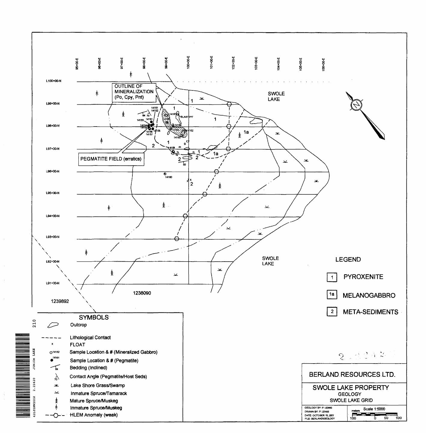
In mid-October, 2001 M.P. Lewis Geological Services was commissioned by Berland Resources Ltd. of Thunder Bay, Ontario to carry out a geological mapping survey over a portion of its Swole Lake property. The area comprised a 9.5 km grid adjacent to the west side of Swole Lake and exclusively within mining claim 1238090 (Figure 2). The grid had recently been constructed to accommodate a HLEM/magnetometer survey over the Swole Lake Cu-Ni PGM prospect. Geological mapping was conducted by Pat Lewis, P.Geo, while prospecting was simultaneously carried out by Mick and Steve Stares of Stares Contracting Corporation.
Traverses, both geological and prospecting, were carried out on all 100 meter spaced grid lines. Outcrop and float is dominanatly confined to a 300 x 350 meter area centered on L98+00-N at BL100+00-N. This area of outcrop and float has a maximum relief of 3-5 meters over the surrounding relatively flat terrain.
Vegetation over the grid area is variably ranging from mature black spruce over the area of highest relief to lake shore open-swamp to immature spruce/tamarack muskeg to mature spruce muskeg to immature spruce muskeg from grid east to grid west.
GEOLOGICAL MAPPING
The Swole Lake property (grid) is underlain by the western portion of the Swole Lake ultramafic- mafic complex. Outcrop exposure, which is limited to the northeast sector of the grid, defines the intrusion to be restricted to an area 300 x 400 meters immediately west of Swole Lake. The extent of the intrusion to the east under Swole Lake is unknown. The composition of the Swole Lake Intrusion varies from melanocratic gabbro in the south to pyroxenite to the north and is bordered to the west by supracrustal rocks, namely banded metasediments. The melanocratic phase of the intrusion is so designated as it contains ^SVo interstitial coarse grained feldspar. The pyroxenite phase contains nil to >5% fine grained feldspar.
ULTRAMAFIC-MAFIC COMPLEXA: Melanogabbro Phase (Unit la)This phase of the intrusion, which comprises the southern portion of the complex, is exposed in just two outcrop localities with the main exposure located along the west shoreline of Swole Lake. Melanogabbro is coarse grained containing sub 3 cm elongated pyroxene crystals (75"^o) in a plagioclase (25 07o) matrix. This phase of the gabbro is non-magnetic with little or no alteration to
-7-
be observed in hand specimen.
B: Pyroxenite (Unit 1)The Swole Lake ultramafic-mafic complex is mainly comprised of pyroxene gabbro (pyroxenite). This particular phase is dark green to black in colour, medium grained (sub 2 cm), massive and is predominantly void of feldspar. The pyroxenite phase of the intrusion is variably altered (actinolite- tremolite+/carbonate) and is locally slight to strongly magnetic.
SUPRACRUSTRAL ROCKSC: MetasedimentsWell bedded metasediments are exposed and define the western limit of the Swole Lake ultramafic- mafic complex in the area of L97+00-N and BL100+00-E. These sediments are well bedded (sub 2 cm), medium grained, sugary texture and compositionally are comprised of sugary quartz (quartzite) and minor amphibolite. Local sub 2 mm euhedral feldspar crystals and the amphibolite are likely due to granitization caused by the intruding gabbro. Sedimentary bedding is orientated at 300 degrees with a 50 degree dip to the south.
FELSIC DYKED: PegamtiteOf potential importance was the discovery of a pegmatite boulder field located immediately grid west of the Swole Lake Cu-Ni mineralized zone on L98+00-N. Up to 12 large angular erratics, comprised of pegmatite and/or meta-sediments are distributed over an area 25.0 meters x 25.0 meters. Pegmatite erratics (sub 2.0 meters x 2.0 meters - Photo l and 2 in appendix I) are comprised of coarse grained milkly white feldspar (40^0), medium to dark purple lepidolite? - lithium-rich mica (25 07o), quartz (1 5*Yo), spodumene crystals? (l O^o), mica (S-4%) and minor amounts of adularia (high temperature feldspar - pink to red in colour) and tantalum. Tantalum crystals as sub 0.5 cm long needles and 0.5 long tabular crystals were sighted in numerous hand specimens.
Increasing demand for tantalum is the result of the metal's use in the production of electronic capacitors and in a variety of specialty metal alloys in the chemical and aerospace industries. This demand and recent escalating commodity price (now lowered) for tantalum has resulted in a number of companies exploring for tantalum in this Crescent Lake area of Northwestern Ontario. The Swole Lake property is located in the Cresent Lake greenstone belt and is situated east of a number of tantalum occurrences, namely the Zigzag Lake and the Seymour Lake occurrences.
The pegmatite erratics are inferred to be in place because of a number of factors: 1) the apparent cluster of the pegmatite and host metasediment erratics and 2) the largest of the pegmatite erratics is in contact with the host metasediment (Photo 3, appendix I). The structural bedding attitude (strike and dip) matches the measured strike and dip (290/64 degrees south) of the outcropping metasediments near L97+00-N. The contact between the host metasediments and the dyke material is orientated at 010/70 degrees west.
A total of nine (9) samples (Table III) were collected from separate erratics within the field and forwarded to XRAL Labs in Toronto to be analyzed for rare metal elements:
-8-
MINERALIZATION
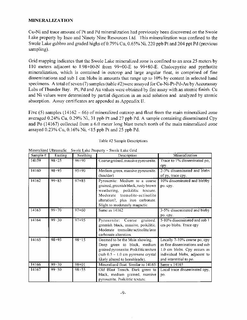
Cu-Ni and trace amount of Pt and Pd mineralization had previously been discovered on the Swole Lake property by Inco and Ninety Nine Resources Ltd. This mineralization was confined to the Swole Lake gabbro and graded highs of Q.79% Cu, G.65% Ni, 220 ppb Pt and 204 ppt Pd (previous sampling).
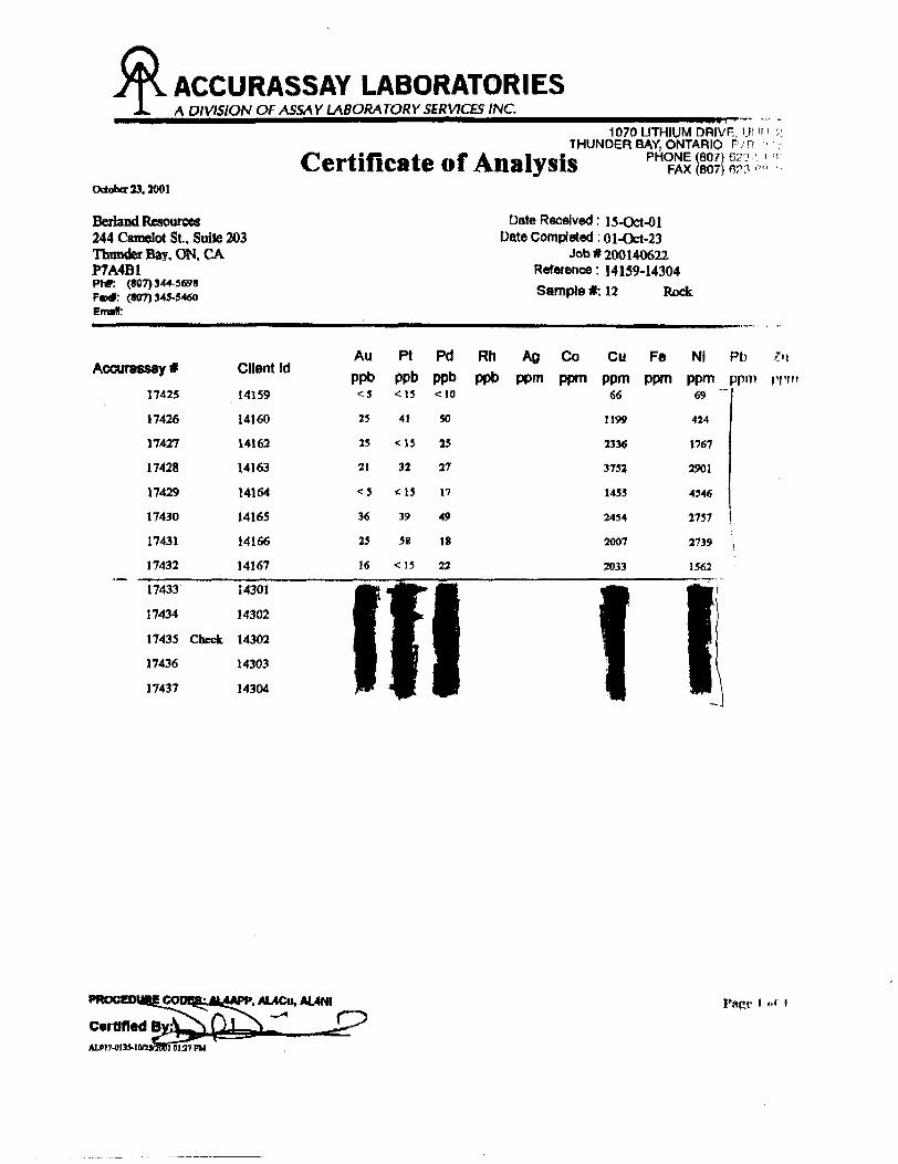
Grid mapping indicates that the Swole Lake mineralized zone is confined to an area 25 meters by 110 meters adjacent to L98+00-N from 99+00-E to 99+80-E. Chalocpyrite and pyrrhotite mineralization, which is contained in outcrop and large angular float, is comprised of fine disseminations and sub l cm blobs in amounts that range up to 1 007o by content in selected hand specimens. A total of seven (7) samples (table #2)were assayed for Cu-Ni-Pt-Pd-Au by Accurassay Labs of Thunder Bay. Pt, Pd and Au values were obtained by fire assay with an atomic finish. Cu and Ni values were determined by partial digestion in an acid solution and analyzed by atomic absorption. Assay certificates are appended as Appendix II.
Five (5) samples (14162 - 66) of mineralized outcrop and float from the main mineralized zone averaged Q.24% Cu, Q.29% Ni, 31 ppb Pt and 27 ppb Pd. A sample containing disseminated Cpy and Po (14167) collected from a 6.0 meter long blast trench north of the main mineralized zone assayed Q.23% Cu, Q.16% Ni, ^5 ppb Pt and 25 ppb Pd.
Table #2 Sample Descriptions
Mineralized Ultramafic Swole Lake Property - Swole Lake GridSample #14159
14160
14162
14163
14164
14165
1416614167
Easting98+25
98+93
99+85
99+70
99+30
98+93
99+3099+50
Northing96+90
95+90
97+85
97+60
97+95
98=15
98+0198+55
DescriptionCoarse grained, massive pyroxenite.
Medium green, massive pyroxenite, (boulder)Pyroxenite: Medium to a coarse grained, greenish black, rusty brown weathering, poikilitic texture. Moderate tremolite-actinolite alteration?, plus iron carbonate. Slight to moderately magneticSame as 14162
Pyroxenite: Coarse grained, greenish black, massive, poikilitic. Moderate tremolite/actinolite/iron carbonate alteration.Deemed to be the Main showing. Deep green to black, medium grained pyroxenite. Poikilitic texture (sub 0.5 - 1.0 cm pyroxene crystal likely altered to hornblende).Mineralized float. Similar to 14165Old Blast Trench. Dark green to black, medium grained, massive pyroxenite. Poikilitic texture.
MineralizationTrace to \ 07o disseminated po, cpy.2-3 07o disseminated and blebs of py, trace cpy.1007o disseminated and blebby po, cpy.
3-5"7o disseminated and bleby po, cpy.S-10% disseminated and sub 1 cm po blobs. Trace cpy
Locally 7-1007o coarse po, cpy as fine disseminations and sub 1.0 cm blobs. Cpy occurs as individual blobs, adjacent to and interstitial to po.Same s 14165Local trace disseminated cpy, po.
-9-

PROSPECTING
The entire gridded area (on and between the cut lines) was prospected by professional prospectors Mick and Steve Stares of Thunder Bay, Ontario. No additional significant sulphide mineralization was discovered. The pegmatite boulder field (described previously) was discovered by prospecting. Sample descriptions are included in table #3 below. Selected assays are reported in table 4 and assay certificates are attached in Appendix III.
Table #3 Sample Descriptions
Pegmatite Erratics Swole Lake Property - Swole Lake GridSample #14151
1415214153
14154
14155
14156/5714158
14162
Easting98+40
98+4098+33
98+20
98+22
98+2598+38
98+25
Northing98+10
98+1198+05
98+04
97+95
97+9097+90
98+20
DescriptionPegmatite Erratic (1 .0 x 2.0 m): Coarse grained pegmatite. 25"7o light purple lepidolite?, 5007o milky white feldspar, 20"7o transparent quartz, occasional spodumene crystal, rare tantalum needle.Same as 14151.25 x .30 m pegmatite erratic. Similar to 14151. Spodumene crystals absent.Large pegmatite erratic underneath tree trunk. 5007o pale pink lepidolite?, 2007o milky white feldspar and 25 07o quartz, S-5% large spodumene crystals.Large pegmatite erratic in muskeg under tree trunk. 33 07a purple lepidolite?, 33 07o quartz and 33 07o feldspar.Same as 14154Large erratic in muskeg. Pegmatite dyke material in contact with quartzite wall rock. Varying proportions of quartz, feldpsar, lepidolite?, spodumene and trace tantalum.Largest of the pegmatite erratics (2.5 x 2.0 meters) 1.5 meters of coarse grained pegmatite in contact with metasedimentary wall rock. Pegmatite dyke material very coarse grained comprised of 25 07o light purple lepidolite, 4007o milky white felspar, 15 07o quartz, 1007o spodumene crystals, 3-407o mica and rare tantalum. Central portion of the dyke (.5 m) displays zoning which is portrayed by enhanced lepidolite and large felspar/spodumene crystals that are perpendicular to dyke contact.
-10-
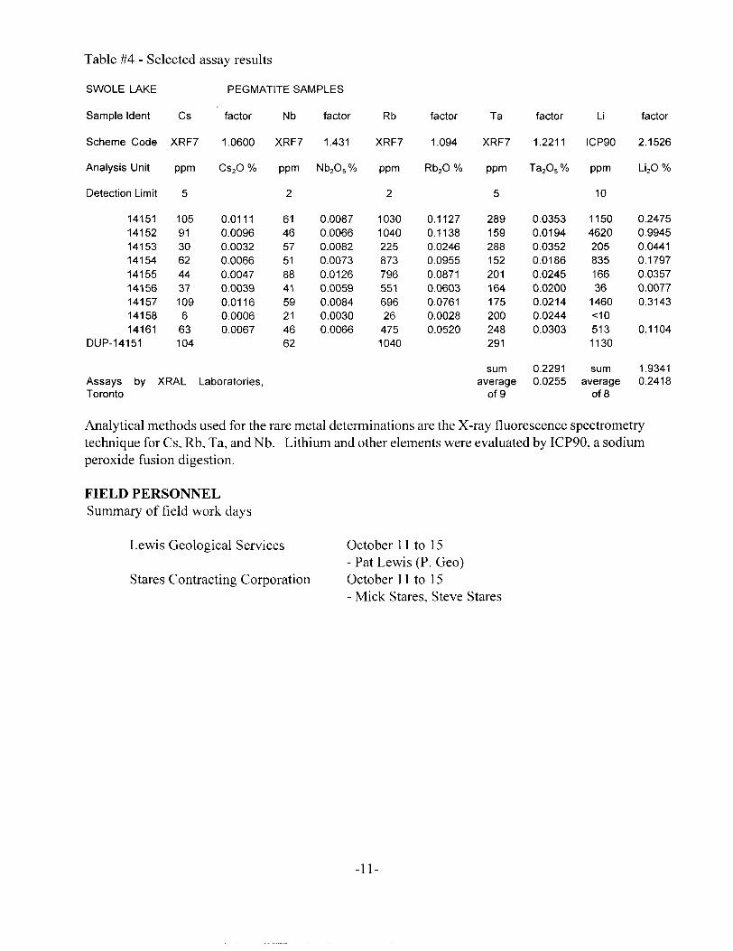
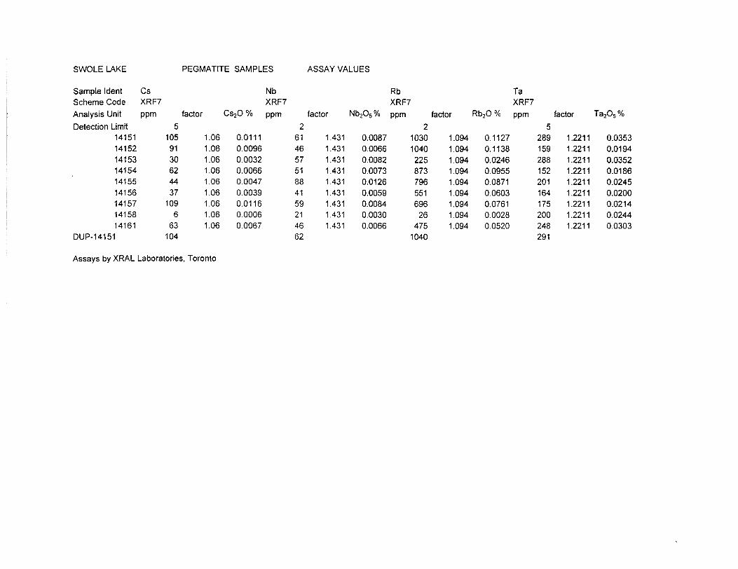
Table #4 - Selected assay results
SWOLE LAKE PEGMATITE SAMPLES
Sample Ident
Scheme Code
Analysis Unit
Detection Limit
141511415214153141541415514156141571415814161
DUP-14151
Cs
XRF7
ppm
5
10591306244371096
63104
factor
1 .0600
CS2 O "/o
0.01110.00960.00320.00660.00470.00390.01160.00060.0067
Nb
XRF7
ppm
2
61465751884159214662
factor
1.431
Nb2O5 07o
0.00870.00660.00820.00730.01260.00590.00840.00300.0066
Rb
XRF7
ppm
2
1030104022587379655169626
4751040
factor
1.094
Rb2 O "/o
0.11270.11380.02460.09550.08710.06030.07610.00280.0520
Ta
XRF7
ppm
5
289159288152201164175200248291
factor
1.2211
Ta2 O5 07o
0.03530.01940.03520.01860.02450.02000.02140.02440.0303
Li
ICP90
ppm
10
1150462020583516636
1460*:105131130
factor
2.1526
Li2 O "/o
0.24750.99450.04410.17970.03570.00770.3143
0.1104
Assays by XRAL Laboratories, Toronto
sumaverage
of 9
0.22910.0255
sumaverage
of 8
1.93410.2418
Analytical methods used for the rare metal determinations are the X-ray fluorescence spectrometry technique for Cs, Rb, Ta, and Nb. Lithium and other elements were evaluated by ICP90, a sodium peroxide fusion digestion.
FIELD PERSONNELSummary of field work days
Lewis Geological Services
Stares Contracting Corporation
October 11 to 15- Pat Lewis (P. Geo) October 11 to 15- Mick Stares, Steve Stares
-11-
CONCLUSION AND RECOMMENDATIONS
Further exploration should be designed to follow up and if possible to expand on the tantalum bearing pegmatite discovery. Prospecting all claims for pegmatite clues, specially near and along the granite contact is important to complete immediately. Geological mapping of all claims in the group would be important to provide a better understanding of the relationship of the pegmatites to the host rocks. To locate the bedrock source of the boulders found on the grid an investigation should be conducted to attempt to determine the nature and depth of overburden and depth of the watertable to evaluate if overburden stripping is a viable alternative program. If the stripping program is deemed to be not viable, a short diamond drill program could be utilized to confirm the bedrock location of the pegmatite.
Respectively co-authored by:
BERLAND RESOURCES LTD. M.P. LEWIS GEOLOGICAL
William McCrindle, P. Eng. M. P. (Patrick) Lewis, P. Geo
-12-
CERTIFICATE OF QUALIFIED PERSON
I, William McCrindle, P. Eng., of the City of Thunder Bay, do hereby certify that:
1. I planned and supervised the contractors on behalf of Berland Resources Ltd.
2. I am the President, a Director and shareholder of Berland Resources Ltd.
3. I hold a Bachelor of Applied Science degree in Geological Engineering from the University of Toronto (l 961).
4. I am registered as a member of the Association of Professional Engineers of Ontario and have been since July 27th , 1984.
5. I worked as a geologist in education and as a consultant from 1961 to 1982. From 1983 to October 1997, I was an Officer and from 1983 to the present, a Director of Cumberland Resources Ltd. I retired from my involvement in education in February, 1995. In October 1997 I was appointed President and Director of Berland Resources Ltd.
Dated at Thunder Bay, Ontario
this 5th day of November, 2001
William McCrindle, P. Eng.
-13-
APPENDIX I
-14-
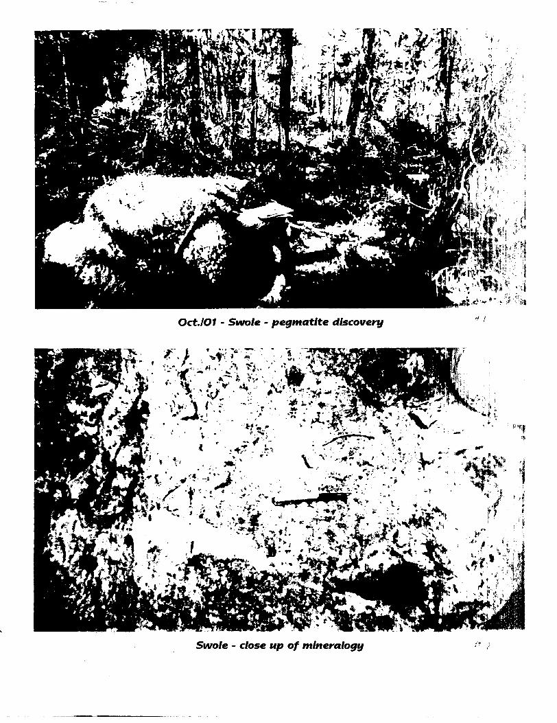
Oct.lOI - Swale - pegmatite discovery
Swole - close up of mineralogy
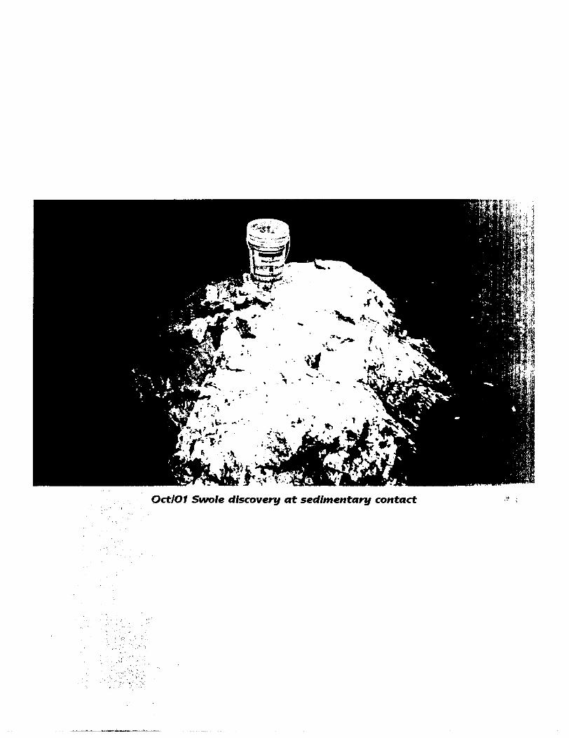
OctlOI Swole discovery at sedimentary contact
APPENDIX II
-15-
ACCURASSAY LABORATORIESA DIVISION OF ASSAY LABORATORY SERVICES /NC
Certificate of Analysis1070 LITHIUM DRIVF-, Ut 1
THUNDER BAY, ONTARIO PH PHONE (607) GSLV.
FAX (807)October 23. 2001
Beriand Resources 244 Camdot St.. Suite 203 Thunder Bay, ON, CA P7A4BIPhff: (807)344-3698 F**: (807)345-5460 Email:
Date Received: 15-Qct-Ol Date Completed : oi-Oct-23
Job #200140622 Reference: 14159-14304Sample #; 12 Rock
Accurassay*17425
17426
17427
17428
17429
17430
17431
17432
Client Id14159
14160
14162
14163
14164
14165
14166
14167
17433 14301
17434 14302
17435 Check 14302
17436 14303
17437 14304
Au R Pd Rh AO Co Cu Fe Ni Pt) ppb ppb ppb ppb ppm ppm ppm ppm ppm ppm
/M
<5 ^ 15
25 41
25 ^3
21 32
36
25
16
39
38
50
25
27
17
49
18
22
66
1199
2336
3752
1453
2454
5007
2033
69
424
1767
2901
4346
2737
2739
1562
f.AL4Cu,AUNI Pape l "' i
APPENDIX III
-16-
SWOLE LAKE PEGMATITE SAMPLES ASSAY VALUES
Sample Ident Cs Nb Rb Ta Scheme Code XRF? XRF7 XRF7 XRF? Analysis Unit ppm factor Cs2 O "/o pprrt factor Nb2O5 "/o ppm factor Rb20 "/o ppm factor Ta205 "/oDetection Limit
141511415214153141541415514156141571415814161
DUP-14151
5105
9130624437
1096
63104
1.061.061.061.061.061.061.061.061.06
0.01110.00960.00320.00660.00470.00390.01160.00060.0067
261465751884159214662
1.4311.4311.4311.4311.4311.4311.4311.4311.431
0.00870.00660.00820.00730.01260.00590.00840.00300.0066
210301040225873796551696
26475
1040
1.0941.0941.0941.0941.0941.0941.0941.0941.094
0.11270.11380.02460.09550.08710.06030.07610.00280.0520
5289159288152201164175200248291
1.22111.22111.22111.22111.22111.22111.22111.22111.2211
0.03530.01940.03520.01860.02450.02000.02140.02440.0303
Assays by XRAL Laboratories, Toronto
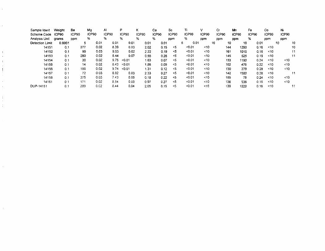
Sample Ident Weight Be Mg Al Scheme Code ICP90 ICP90 ICP90 ICP90Analysis Unit grams ppm "/o Detection Limit 0.0001 5
141511415214153141541415514156141571415814161
DUP-14151
0.10.10.10.10.10.10.10.10.10.1
27790
2803014
19072
375171289
"/o
0.010.020.030.020.020.020.020.030.030.020.02
P K Ca Se Ti V Cr Mn Fe Co Ni ICP90 ICP90 ICP90 ICP90 ICP90 ICP90 ICP90 ICP90 ICP90 ICP90 ICP90"/o "/o
0.01 0.018.399.038.449.758.439.748.927438.548.44
0.030.020.07
O.010.01O.01
0.030.050.030.04
"/o
0.012.022.220.551.631.861.312.330.180.972.05
ppm 0.010.15 ^0.19 ^0.28 ^0.07 ^0.09 ^0.12 ^0.27 ^0.22 ^0.27 ^0.15 ^
"/o ppm ppm ppm "k 5 0.01 10 10 10
O.01 ^0 144O.01 ^0 161O.01 ^0 145O.01 ^0 153O.01 t10 152O.01 "MO 130O.01 ^0 142O.01 *c10 185O.01 ^0 136O.01 -:10 139
12901010525
1190476279
158078
5361220
ppm ppm 0.01 10 100.16 -:100.16 -slO0.19 ^00.24 ^00.22 -:100.28 -c100.28 ^00.24 -:100.15 *:100.16 <10
101111
<10<10<10
11•e10<10
11
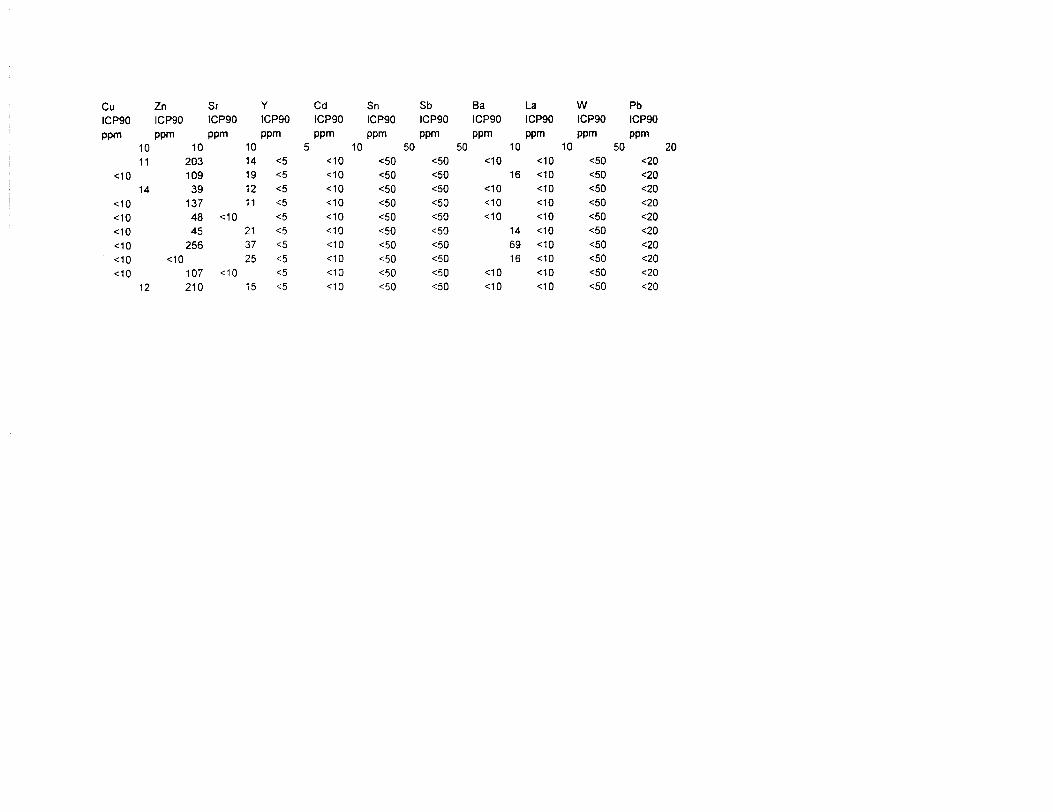
Cu Zn Sr Y Cd Sn Sb Ba La W Pb ICP90 ICP90 ICP90 ICP90 ICP90 ICP90 ICP90 ICP90 ICP90 ICP90 ICP90ppm ppm ppm ppm ppm ppm ppm ppm ppm ppm ppm
1011
^014
MO*^10*MO^0^0C10
12
102031093913748 *45256
:10
107 <210
10 514 ^ <19 <5 <12 ^ <11 <5 <
:10 <5 <21 <5 <37 <5 <25 ^5 <
:10 <5 <15 ^ <
10 50:10 <50:10 <50:10 ^0:10 <50:10 <50:10 <50:10 <50:10 ^50 10 <50:10 <50
50^0 <<50<50 *<50 <<50 <<50<50<50<50 <^0 <
10:10 <
16 <:10 <:10 <:10 <
14 <69 <16 <
:10 < 10 <
10 50:10 <50:10 <50:10 <5010 <5010 ^010 <5010 <5010 <5010 <5010 ^0
<20<20<20<20^0<20<20<20<20^0
20
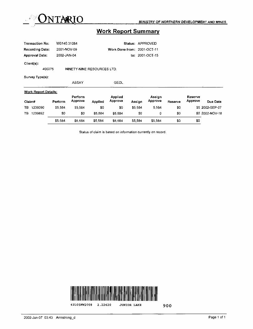
ONTMRIO MINISTRY OF NORTHERN DEVELOPMENT AND MINES
Transaction No:
Recording Date:
Approval Date:
Client(s):
400275
Survey Type(s):
W0140.31084
2001-NOV-09
2002-JAN-04
Work Report Summary
Status: APPROVED
Work Done from: 2001-OCT-11
to: 2001-OCT-15
NINETY-NINE RESOURCES LTD.
ASSAY GEOL
Work Report Details:
Claim*
TB
TB
1238090
1239892
Perform
35,584
SO
35,584
Perform Approve
35,584
30
35,584
Applied
30
55,584
35,584
Applied Approve
30
35,584
35,584
Assign
35,584
30
35,584
Assign Approve
5,584
0
35,584
Reserve
soSO
SO
Reserve Approve
SO
30
so
Due Date
2002-SEP-07
2002-NOV-18
Status of claim is based on information currently on record.
42L05NW2008 2.22420 JUNIOR LAKE 900
2002-Jan-07 03:43 Armstrongjd Page 1 of 1
Ministry ofNorthern Developmentand Mines
Date: 2002-JAN-04
Ministere du Developpement du Nord et des Mines Ontario
GEOSCIENCE ASSESSMENT OFFICE 933 RAMSEY LAKE ROAD, 6th FLOOR SUDBURY, ONTARIO P3E6B5
NINETY-NINE RESOURCES LTD. 5560 HOLT AVENUE RICHMOND, BRITISH COLUMBIA V7C 5C8 CANADA
Tel: (888)415-9845 Fax:(877)670-1555
Dear Sir or Madam
Submission Number: 2.22420 Transaction Number(s): W0140.31084
Subject: Approval of Assessment Work
We have approved your Assessment Work Submission with the above noted Transaction Number(s). The attached Work Report Summary indicates the results of the approval.
At the discretion of the Ministry, the assessment work performed on the mining lands noted in this work report may be subject to inspection and/or investigation at any time.
If you have any question regarding this correspondence, please contact BRUCE GATES by email at [email protected] or by phone at (705) 670-5856.
Yours Sincerely,
Ron GashinskiSupervisor, Geoscience Assessment Office
Cc: Resident Geologist
Ninety-Nine Resources Ltd. (Claim Holder)
Assessment File Library
Ninety-Nine Resources Ltd. (Assessment Office)
Visit our website at http://www.gov.on.ca/MNDM/LANDS/mlsrnnpge.htm Page: 1 Correspondence 10:16704
o o
MINING LAND TENURE
MAP
'..WISUUllW l ^S
U/
1H iWlfc
—^"
\Q^ ^ /""^ V --4J j^f-r,V-v" -X| J \' ] ^-^::-
-" X \ O-/ y-"^^^ ,-;?^-:~———,2
J*^\*J*^ ^ ^"^f^ ̂ ^A*-, ^—- ^T^ x ^ v^^^ v^A" ^ V^ ^ ^ r^a^VJ ^---'•""
:. w;: ,...,,....^,..a-,
i y 1187164^-x,.......,,,::V 1187561
1J17lst j-—i—,
-V lil,linn l^mt
LsLJ .,-p. v "1077141 107714K
1217180 i y
Diila f Time of Issue Nov232001
TOWNSHIP r AREA
JUNIOR LAKE AREA
11:OBh Eastern
PLAN
G-O 057
ADMINISTRATIVE DISTRICTS ; DIVISIONSMining Division Thunder Bay
Land TttlCBfRBgistry Division THUNDER BAY
Mlnlstfy of Natural Resoureo* Dlttflct NIPIGON
TOPOGRAPHIC LAND TENURE
G G
EHirwin? *f
a aGa
0ta a
LAND TENURE WITHDRAWALS
i__JIMPORTANT NOTICES
LAND TENURE WITHDRAWAL DESCRIPTIONS
IMPORTANT NOTICES
oJ
rv IM Minn^ ^ rniflot'i' J Hi rjiiiH MiMfir/ ul Uuiiiiricib iinvwniiixvri dm HI dl lnrvdy ur Una nil* it lam rain ftiiui puifOMf^ an Ilia ml^nri4Hhi.i| nhtmuri in (liii in*V din hn p^lnvd Tfcr^ujti Uw hir H l wilt Itttok ur Hilary d Mm. 01
General Information and Limitations
8
L10Q+00-N
L99+00-N
L98+00-N
L97-KDO-N
L96+00-N
OUTLINE OF MINERALIZATION (Po, Cpy, Pnt)
SWOLE LAKE
PEGMATITE FIELD (erratics)
LS5+00-N
SWOLE LAKE
oHrsi
x o
x
Q14162
• *16t
64
—O—
SYMBOLSOutcrop
Lithological ContactFLOATSample Location S # (Mineralized Gabbro)
Sample Location 8t # (Pegmatite) Bedding (inclined)
Contact Angle (Pegmatite/Host Seds)
Lake Shore Grass/Swamp Inmature Spruce/Tamarack Mature Spruce/Muskeg Inmatupe Spruce/Muskeg HLEM Anomaly (weak)
LEGEND
PYROXENITE
1a MELANOGABBRO
META-SEDIMENTS
BERLAND RESOURCES LTD.
SWOLE LAKE PROPERTYGEOLOGY
SWOLE LAKE GRIDGEOLOSY BT: P. IBMS DRAWN Bf: P. LRMS DATfe OCTOBER 15, 3001 FILE: BERLANCT3ECXOGY
meter*
P 100
Scate 1:5000
O 50 100