Embed Size (px)
Citation preview

Bacolod City
Table1. Results of Landslide Assessment of the barangays
Barangay Name Landslide Susceptibility Rating
1 Monte Vista Low
2 Vista Alegre Low
3 Alangilan None to Low
4 Granada None to Low
5 Alijis None
6 Banago None
7 Brgy. 1 (Poblacion) None
8 Brgy. 2 (Poblacion) None
9 Brgy. 3 (Poblacion) None
10 Brgy. 4 (Poblacion) None
11 Brgy. 5 (Poblacion) None
12 Brgy. 6 (Poblacion) None
13 Brgy. 7 (Poblacion) None
14 Brgy. 8 (Poblacion) None
15 Brgy. 9(Poblacion) None
16 Brgy. 10 (Poblacion) None
17 Brgy. 11 (Poblacion) None
18 Brgy. 12 (Poblacion) None
19 Brgy. 13 (Poblacion) None
20 Brgy. 14 (Poblacion) None
21 Brgy. 15(Poblacion) None
22 Brgy. 16 (Poblacion) None
23 Brgy. 17 (Poblacion) None

24 Brgy. 18 (Poblacion) None
25 Brgy. 19 (Poblacion) None
26 Brgy. 20 (Poblacion) None
27 Brgy. 21 (Poblacion) None
28 Brgy. 22 (Poblacion) None
29 Brgy. 23 (Poblacion) None
30 Brgy. 24 (Poblacion) None
31 Brgy. 25 (Poblacion) None
32 Brgy. 26 (Poblacion) None
33 Brgy. 27 (Poblacion) None
34 Brgy. 28 (Poblacion) None
35 Brgy. 29 (Poblacion) None
36 Brgy. 30 (Poblacion) None
37 Brgy. 31(Poblacion) None
38 Brgy. 32 (Poblacion) None
39 Brgy. 33 (Poblacion) None
40 Brgy. 34 (Poblacion) None
41 Brgy. 35 (Poblacion) None
42 Brgy. 36 (Poblacion) None
43 Brgy. 37 (Poblacion) None
44 Brgy. 38 (Poblacion) None
45 Brgy. 39 (Poblacion) None
46 Brgy. 40 (Poblacion) None
47 Brgy. 41 (Poblacion) None
48 Bata None

49 Cabug None
50 Estefania None
51 Felisa None
52 Handumanan None
53 Mandalagan None
54 Mansilingan None
55 Pahanocoy None
56 Punta Taytay None
57 Singcang None
58 Sum-ag None
59 Taculing None
60 Tangub None
61 Villamonte None
Table 2. Results of Flood Assessment of the Barangays
Barangay Name Remarks/ Recommendations
1 Alangilan Low flood depth of 0-0.5 m and flash flood with low turbidity are rarely experienced at the barangay.
2 Alijis Low flood depth of 0-0.5 m is rarely experienced at the barangay
3 Banago Moderate flood depth of 0.5-1m is seasonally experienced at Puroks Cawayan and Catilingban while high flood depth of >1m affects Purok Riverside.
4 Brgy. 1 (Poblacion) Moderate flood depth of 0.5-1m affects Purok Ylac during rainy season.
5 Brgy. 2 (Poblacion) High flood depth of >1m is seasonally experienced at Purok Sigay.
6 Brgy. 3 (Poblacion) Moderate flood depth of 0.5-1m seasonally affects the Brgy. Proper, Puroks Nanca, Tilapia, Lubian 1 & 2, Cereza North & South and Zones 1 & 2.
7 Brgy. 4 (Poblacion) Moderate flood depth of 0.5-1m is seasonally experienced at the barangay especially when high tide coincides with the heavy downpour of rain. Storm surge also causes flooding in the area.
8 Brgy. 5 (Poblacion) Overflowing of Mandalagan Creek during typhoons and heavy rainfall causes low flood depth of 0-0.5m.
9 Brgy. 6 (Poblacion) Moderate flood depth of 0.5-1m affects the barangay. Purok Masagana, Pilit I and II are usually flooded with 2 ft. of water during heavy rains. Flooding is caused by inadequate drainage system.
10 Brgy. 7 (Poblacion) Moderate to high flood depth of 0.5->1m affect the barangay. Purok Magnolia and Coca-cola are flooded at least waist-high. Causes of flooding include storm surges, silted/clogged and inadequate drainage. Several houses are built along waterways.
11 Brgy. 8 (Poblacion) High flood depth of >1m affects the barangay. Flooding occurs at least 3x a year. Three yrs ago, 70 families were affected by flooding. Causes of flooding include simultaneous occurrences of high tide and heavy rains storm surges, silted/clogged

and inadequate drainage. 12 Brgy. 9 (Poblacion) Moderate to high flood depth of 0.5->1m affect the barangay. Floodwaters reaching
>1m high was experienced by the bgy. several years ago.
13 Brgy. 10 (Poblacion) Moderate flood depth of 0.5->1m affect the barangay. Causes of flooding include storm surges, silted/clogged and inadequate drainage. Storm surge and coastal flooding affects at least 20 families. Regular clearing of waterways i.e. drainage system, creek.
14 Brgy. 11 (Poblacion) Moderate flood depth of 0.5->1m affect the barangay. Purok Dama de Noche and Cadena de Amor are regularly flooded during heavy rainfall. Causes of flooding include large volume of rainfall, silted/clogged/blocked and inadequate drainage.
15 Brgy. 12 (Poblacion) Moderate to high flood depth of 0.5->1m affect the barangay. The barangay is a reclaimed area and is flooded twice a year. Flood-prone areas include Purok Malipayon and Masinadyahon.
16 Brgy. 13 (Poblacion) High flood depth of 0.5->1m affect the barangay. Flood-prone areas include Purok Boulevard and Bagong Unlad. Creek is heavily clogged with garbage and other debris.
17 Brgy. 14 (Poblacion) Low flood depth of 0-0.5 m rarely occurs in the area. No alarming flooding incident
18 Brgy. 15 (Poblacion) Low to moderate flood depth of 0-1 m rarely occurs in the area. Barangay was flooded during Typhoon Ruping and Peping. Brgy. hall is located at the reclaimed area formerly a portion of Maupay Creek..
19 Brgy. 16 (Poblacion) Moderate flood depth of 0-1 m rarely occurs in the area. Duration of flooding is 2 days. Cause of flooding is silted/clogged/blocked and inadequate drainage.
20 Brgy. 17 (Poblacion) Low flood depth of 0-0.5 m rarely occurs in the area. Cause of flooding is silted/clogged/blocked and inadequate drainage.
21 Brgy. 18 (Poblacion) Moderate flood depth of 0-1 m rarely occurs in the area. Purok Interior near an unnamed creek is flooded. Duration of flooding is 24 hours.
22 Brgy. 19 (Poblacion) None.
23 Brgy. 20 (Poblacion) None at the brgy. proper. High flood depth of 0->1 m occurs in Purok Avocado, near an unnamed creek is flooded.
24 Brgy. 21 (Poblacion) Moderate flood depth of 0-1 m occurs in the area. Purok Paghidait, near an unnamed creek is flooded.
25 Brgy. 22 (Poblacion) Low flood depth of 0-0.5 m occurs in the area. Floodwaters recede easily after 2 hrs. Cause of flooding is drainage problem.
26 Brgy. 23 (Poblacion) Low flood depth of 0-0.5m occurs in the area. Purok Masinulondon is located in a low-lying area and is flooded. Floodwaters recede easily..
27 Brgy. 24 (Poblacion) None
28 Brgy. 25 (Poblacion) None

29 Brgy. 26 (Poblacion) None
30 Brgy. 27 (Poblacion) Low flood depth of 0-0.5m occurs in the area. Brgy. proper has drainage problem. Floodwaters recede after 24 hours.
31 Brgy. 28 (Poblacion) Low flood depth of 0-0.5m occurs in the area during simultaneous occurrences of high tide and unusually heavy rain. Flood-prone areas include Purok Chico, Lumboy and Ipil-ipil. Purok Chico has no proper drainage facility. Floodwaters recede after 24 hours.
32 Brgy. 29 (Poblacion) None
33 Brgy. 30 (Poblacion) None
34 Brgy. 31 (Poblacion) Moderate flood depth of 0-1 m occurs in the area. Purok Sto. Tomas, located along the river is flooded and 20 households are affected.
35 Brgy. 32 (Poblacion) None
36 Brgy. 33 (Poblacion) None
37 Brgy. 34 (Poblacion) None
38 Brgy. 35 (Poblacion) Purok Malipayon (mouth of Lupit River), Maabi-abihon and Mahiliugyon are flood-prone areas. Flooding occurs during simultaneous occurrences of high tide (>2m) and heavy rains.
39 Brgy. 36 (Poblacion) Moderate flood depth of 0-1 m occurs in the area. Purok Litsonan is prone to flashfloods. Worst flood in the area is during Typhoon Pepang.
40 Brgy. 37 (Poblacion) Moderate flood depth of 0-1 m occurs in the area. Purok Sto. Niño is flood-prone, 30-35 households are affected.
41 Brgy. 38 (Poblacion) Moderate flood depth of 0-1 m occurs in the area. Purok Camia and Sampaguita are flood-prone. Flooding occurs during simultaneous occurrences of high tide (>2m) and heavy rains. Cause of flooding is clogged drainage. Worst flood occurred last 1995.
42 Brgy. 39 (Poblacion) High flood depth of >1 m occurs in the area. Purok Katilingban 1 and 2 are flood-prone. Flooding occurs during simultaneous occurrences of high tide (>2m) and heavy rains, about 200 households are affected.
43 Brgy. 40 (Poblacion) High flood depth of >1 m occurs in the area. Purok Bagong Katilingban, Ammaliz 1, Malinong are flood-prone. Flashflood occurred last Oct. 28, 1995 (Typhoon Pepang), 11 houses were totally damaged in Ammaliz-1.

44 Brgy. 41 (Poblacion) High flood depth of >1 m occurs in the area. Purok 4 and 5 are flood-prone, 30 families are affected along the river.
45 Bata Low flood depth of 0-0.5 m occurs in the brgy. proper. Moderate flood depth of 0-1 m occurs in Purok Sawmill 1, 2 and 3, Mabinoligay Block 17.
46 Cabug None in brgy. proper. Flooding occurs in Purok Lechonan, Santan and Casanayan. Flooding depth at 0.5 m. Cause of flooding is narrowing of waterways due to reclamation of creek banks.
47 Estefania Low flood depth of 0-0.5 m occurs in the brgy. proper.
48 Felisa None in brgy. proper. Flooding occurs in Purok Paghidaet, Mahirop, Gahiliugyon, Matinianon, Maabiabihon with flooding depth of >1 m due to overflowing of water from two creeks.
49 Granada Low flood depth of 0-0.5 m occurs in the brgy. proper. Moderate flood depth of 0-1 m occurs in San Dionisio Subd. area and in farmlands.
50 Handumanan None to low in Brgy. proper. Flooding in Zone 10 with depth of 0.5 m is caused by drainage problem.
51 Mandalagan Low flood depth of 0-0.5 m occurs in the brgy. proper. Moderate flood depth of 0-1 m occurs near/along Mandalagan River, Purok Carvic, in front of Robinson’s.
52 Mansilingan None to low in Brgy. proper. Moderate flood depth of 0-1 m occurs in Purok Himaya, Ermelinda Homes, Casilingan, Purok Mabinuligon.
53 Monte Vista None
54 Pahanocoy None
55 Punta Taytay High flood depth of >1 m occurs in the area due to its location between two converging bodies of water (Sum-ag River and Punta Taytay Creek). Also prone to flashfloods, coastal flooding, storm surges and coastal erosion. Coastal erosion affects 1 meter of shoreline.
56 Singcang High flood depth of >1 m occurs in the area. Floods in 1970, 1986 and 1993 are neck-deep. Also prone to surges and coastal erosion.
57 Sum-Ag None in Brgy. proper. High flood depth of >1 m occurs in Purok Mahigugmaon, candelaria, Casanagan and san Benito. No drainage system in Purok Progreso, Fatima, San Jose 2, nami-nami-1, San Sebastian and Magayon.
58 Taculing High flood depth of >1 m occurs in the area. Flood-prone areas include Purok Lirio, BCC College, Puentebella area, Sharina Heights, St. John area, Doña Juliana, City High School area, City heights. Cause of flooding is low topography of the area and poor drainage system.
59 Tangub Low flood depth of 0-0.5 m occurs in the brgy. proper. Flood-prone areas include Purok Paghidait, Matahum, Roadside and San Roque. Flooding is caused by simultaneous occurrences of high tide (>2m) and heavy rains, clogged drainage and lack of drainage system.
60 Villamonte Low flood depth of 0-0.5 m occurs in the brgy. proper. Moderate flood depth of 0-1 m occurs in Herbias 2, Solong 2, Kabakawan, Purok 18, Herba Buena, medalla, milagrosa, Purok Chavez, Hubay.
61 Vista Alegre Low flood depth of 0-0.5 m occurs in the brgy. proper. Villa Angela is flood-prone but has not experienced flooding.
Bago City
Table1. Results of Landslide Assessment of the barangays
Barangay Name Landslide Susceptibility Rating
1 Ilijan None at the Brgy. Proper; High at Purok Malunggay B
2 Mailum None at the Brgy. Proper; High at Puroks Manghumay and Abaka
3 Binubuhan None
4 Ma-ao None
5 Bacong None
6 Sampinit None
7 Balingasag None
8 Calumangan None
9 Lag-asan None
10 Poblacion None
11 Sagasa None
12 Caridad None
13 Alianza None
14 Bagroy None
15 Abuanan None
16 Dulao None
17 Tabunan None
18 Taloc None
19 Busay None
20 Napoles None
21 Don Jorge Araneta None
22 Malingin None
23 Pacol None
24 Atipuluan None
Table 2. Results of Flood Assessment of the Barangays
Barangay Name Remarks/ Recommendations
1 Abuanan High flood depth of >1m affects Hacienda Encarnacion. Floodwaters emanate from Bago River.
2 Alianza Low flood depth of 0-0.5 m and flashflood with low turbidity rarely occur at the barangay.
3 Atipuluan High flood depth of >1m rarely occurs. A flooding incident in year 1994 or 1995 led to 26 casualties at Purok Riverside caused by the overflowing of Bago River.
4 Bacong High flood depth of >1m and flash flood with high turbidity rarely occurs. Overflowing of Sapa Creek during Typhoon Uring (1991) and Typhoon Ondoy (2009) affected approximately 12 houses at Purok Tuburan. Overflowing of Bantulinao River also affects Sitios Kawayan, Humayan, Paraiso, Kalubihan, Abi-abihon and Pine Tree.
5 Bagroy Low flood depth of 0-0.5 m and flashflood with low turbidity rarely occur at the barangay. Moderate flood depth of 0.5-1 m affects agricultural lands.
6 Balingasag High flood depth of >1m is seasonally experienced at areas near the Sibud Creek affecting approximately 40 households in the area.
7 Binubuhan High flood depth of >1m is seasonally experienced at Puroks Waterlily (25 households affected), Daisy (10 households affected), Yellow Bell (16 households affected), Sunflower (3 houses near riverbanks affected) and Sampaguita/Proper (30 houses affected). Flooding is caused by the overflowing of Maragandang and Palipian Rivers.
8 Busay Low flood depth of 0-0.5 m rarely occurs. High flood depth of >1 m affects Puroks Nipa and Balenghoy due to the overflowing of Busay River.
9 Calumangan High flood depth of >1m is seasonally experienced at the back of barangay hall.
10 Caridad Low flood depth of 0-0.5 m rarely occurs while high flood depth of >1m affects houses along Bago River at Purok Bayabas 1.
11 Don Jorge Araneta Low flood depth of 0-0.5 m seasonally affects Hacienda Guba, portions of Hacienda Zaragosa, Purok Riverside and portions of Purok Canlaon. Floodwaters emanate from Maragandang River. Riverbank erosion also present at Hacienda Guba. A flash flood incident in year 1995 affected some puroks of the barangay.
12 Dulao High flood depth of >1m is seasonally experienced at Purok Salong due to drainage-related problem.
13 Ilijan High flood depth of >1m affects Purok Talong and resulted to 2 casualties due to the overflowing of Nakalang River. Bank scouring affects Puroks Kapayas and Malunggay.
14 Lag-asan High flood depth of >1m is seasonally experienced at the barangay. Worst flooding incident was during Typhoon Ruping.
15 Ma-ao High flood depth of >1m rarely affects the barangay.. Flash flood with low turbidity commonly occurs. During Typhoon Uring (2002), overflowing of Ma-ao River caused flooding at Purok Riverside of Mabuhay and Purok Bagong Silang. 10 houses were washed away resulting to 8 casualties. Continuous rains also affect Purok Ipil-ipil, Narra and D-64 with high flood depth of >1m.

16 Mailum Low flood depth of 0-0.5 m and flashflood with low turbidity rarely occur at the barangay affecting Puroks Tisa and Esperanza during continuous and heavy rains.
17 Malingin High flood depth of >1m due to the overflowing of Bago River seasonally affects Puroks Tuburan, Star-apple, Narra and Riverside. Drainage-related problem causes low flood depth of 0-0.5 m at Puroks Saging, Cawayanan and portions of Purok Gabi (Brgy. Proper).
18 Napoles High flood depth of >1m is experienced at Puroks Quarry Site, Langka, Suha, Paho, Riverside, Mainuswagon and Malipayo. Floodwaters emanate from Bago River during heavy rains and typhoons. Purok Malunggay is likewise flooded by the overflowing of Sibud Creek while Purok Bibi is affected by flood due to drainage-related problem.
19 Pacol Low flood depth of 0-0.5 m seasonally affects Puroks Calubay, Camatis and Gaway-Gaway. Flooding during rainy season is caused by the overflowing of the irrigation canal and insufficient drainage system.
20 Poblacion High flood depth of >1m seasonally occurs. The entire barangay was affected by flooding during Typhoon Ondoy.
21 Sagasa Low flood depth of 0-0.5 m and flash flood with moderate turbidity rarely occur at the barangay. High flood depth of >1m affects Puroks Malinong, San Nicolas and other low-lying areas and houses along Sagasa Creek.
22 Sampinit High flood depth of >1m affects Puroks Mabinuligon, Maghili-ugyon, Araneta St. , Kamunsil, Mainuswagon and along Rafael Salas Drive during continuous rainfall. Coastal erosion also affects areas near the coast.
23 Tabunan None
24 Taloc High flood depth of >1m affects Purok Ramos due to the overflowing of Punta Taytay Creek during rainy season. Low flood depth of 0-0.5 m likewise affects Purok Paho South. Floodwaters emanate from Taloc Creek.
Municipality of Binalbagan
Table1. Results of Landslide Assessment of the barangays
Barangay Name Landslide Susceptibility Rating
1 Amontay Moderate at the Brgy. Proper; High on steeply sloping areas
2 Santol None at the Brgy. Proper; Moderate on slopes bounding Purok Kapayran
3 Biao None at the Brgy. Proper; Moderate on steep slopes
4 Progreso (Pob.) None
5 San Jose None
6 San Juan (Pob.) None
7 Marina (Pob.) None
8 San Vicente (Pob.) None
9 San Teodoro (Pob.) None
10 Paglaum (Pob.) None

11 Canmoros (Pob.) None
12 Enclaro None
13 Santo Rosario (Pob.) None
14 San Pedro (Pob.) None
15 Bagroy None
16 Payao None
Table 2. Results of Flood Assessment of the Barangays
Barangay Name Remarks/ Recommendations
1 Amontay Flash flood with high turbidity commonly affects areas near Nabilog River. It takes 2 hours before flood waters subside.
2 Bagroy High flood depth of >1m is seasonally experienced at the barangay during heavy rains and typhoons. During Typhoon Ruping, almost all the houses including agricultural lands along Guintubhan River and National Highway were flooded. Sugarcane fields at Sitio San Agustin are usually affected during rainy season.
3 Biao High flood depth of >1m affects the barangay during heavy rains and typhoons. In year 2009, the overflowing of Pagiplan River resulted to 1 casualty. Some carabaos and livestock also drowned. Agricultural lands of Sitio Candida were also affected.
4 Canmoros (Pob.) High flood depth of >1m is seasonally experienced at Purok Panay, Tuway and Bubu during heavy rains and typhoons. Coastal area is prone to storm surge.
5 Enclaro Coastal area is prone to flooding.
6 Marina (Pob.) Worst flooding incident which lasted for 1 week affected the whole barangay with high flood depth of >1m. Purok Talisay is often flooded during heavy rains affecting about 60 households.. Dredging of Tanolo River is also recommended.
7 Paglaum (Pob.) Worst flooding incident which lasted for 1 week affected almost the entire barangay during Typhoon Ruping. Moderate flood depth of 0.5-1m is experienced at the Brgy. Proper while areas along the riverbank are flooded with 2 to 3 m flood height. Purok Riverside, Sampaguita Extension, Waling Waling and Tanate Bridge are usually flooded during heavy rains and typhoons.
8 Payao High flood depth of >1m affects Sitio Manolita, JMA and Esperanza. Sugarcane plantations and about 50 houses are affected by flood during heavy rains and typhoons.
9 Progreso (Pob.) High flood depth of >1m is seasonally experienced at the barangay during heavy rains and typhoons. The following are the areas affected: Sitio Carmen, Purok Kauswagan, Hacienda Carmen, Sitio Torres and Sitio Isla. About 400 houses near the coast can be affected by storm surge.
10 San Jose High flood depth of >1m is seasonally experienced at the barangay. Worst flooding incident was during Typhoon Ruping. Sitio Loreto, Si-ay, Lourdes, Garazon, Baquias and Sumakwel are the affected areas.
11 San Juan (Pob.) High flood depth of >1m is seasonally experienced at Purok Punta, Baybay I and II. Worst case was during Typhoon Ruping. Whole barangay is surrounded by Tagda River and Guimaras Strait. About 187 households along the coast can be affected by storm surge and coastal flooding.
12 San Pedro (Pob.) Worst flooding event which lasted for 2 to 3 days affected Sitio Isla with high flood depth of >1m during Typhoon Ruping.
13 San Teodoro (Pob.) High flood depth of >1m affects Purok Apitong and Narra during heavy rains and typhoons. Overflowing of Alimango Creek can affect about 86 households. Worst

flooding incident was during Typhoon Ruping wherein whole area was flooded with water level reaching 3 to 4 meters high.
14 San Vicente (Pob.) High flood depth of >1m affects the barangay during heavy rains and typhoons. Worst flooding event was during Typhoon Ruping wherein high water level submerged even the National Highway. Flood water subsides after 2 to 3 days.
15 Santo Rosario (Pob.) Worst flooding incident which lasted for 3 days affected the whole barangay with moderate flood depth of 0.5-1m during Typhoon Ruping. During wet season, rains for 2 to 3 days can cause low flood depth of 0-0.5m within the Brgy. Proper.
16 Santol High flood depth of >1m is seasonally experienced at the barangay. Flash flood with high turbidity commonly occurs and affect Puroks Kabalian and Amilis in Sitio Abaca. More than 10 casualties from flash flood have been recorded since year 1985. More than 10 hectares of crop lands in Purok Amilis including livestock and properties of barangay residents were damaged by flood waters.
Cadiz City
Table1. Results of Landslide Assessment of the barangays
Barangay Name Landslide Susceptibility Rating
1 Jerusalem Low
2 Magsaysay Low
3 Cabahug None; but low in hilly areas
4 Andres Bonifacio None
5 Banquerohan None
6 Barangay Zone 1 None
7 Barangay Zone 2 None
8 Barangay Zone 3 None
9 Barangay Zone 4 None
10 Barangay Zone 5 None
11 Barangay Zone 6 None
12 Burgos None
13 Cadiz Viejo None
14 Caduha-an None
15 Daga None
16 Luna None

17 Mabini None at Brgy. Proper; low at Sitio Igcamalig
18 Sicaba None
19 Tiglawigan None
20 Tinampa-an None
21 C. Villacin High
22 V.F. Gustilo High
Table 2. Results of Flood Assessment of the Barangays
Barangay Name Remarks/ Recommendations
1 Jerusalem None at barangay proper; high flood depth of >1m is experienced in low- lying areas particularly in Hacienda Joanna and Purok Tumpok.
2 Magsaysay High flood depth of >1m is experienced in this area during Typhoon Ruping that lasts for 2-3 days.
3 Cabahug Worst flood history is during typhoon Undoy with >1m flood level at Purok Sisoy, 2-3 hrs flood located near Paniquiran River, silted river channel. One household recorded damaged by the floodwater. Recommendation: Regular dredging of river channel. Constant communication and update with Brgy. Tinampa-an.
4 Andres Bonifacio None at barangay proper; however, in 1997 river bank erosion destroyed 2 concrete bridges located within Hacienda Pepita due to strong river current.
5 Banquerohan Moderate flood depth of 0.5-1m. at Sta. cruz Heights Housing and So. Canipa-an during continuous heavy downpour. Recommendations: Constant communication and update with Brgy. Zone 6.
6 Barangay Zone 1 Coastal area is prone to storm surge. Whole barangay experience flooding during heavy downpour at moderate flood 0.5-1m high. Recommendations: Constant communication and update with Brgy. Zone 2.
7 Barangay Zone 2 Moderate flood depth of 0.5-1m. at Purok Andrea during continuous heavy rains coincident with high tide level. Area is within fishpond affecting approximately 870 household in the nearby subdivision area. Recommendations: Improve drainage facility at Purok Andrea (Andrea Village) and install flood-mitigating structures to minimize if not to prevent tidal flooding in the area. Constant communication and update with Brgy. Zone 3.

8 Barangay Zone 3 Barangay proper flooded during continuous heavy rains due to insufficient drainage facility. Low-lying area near the coast mostly affected by flood during heavy downpour coincident with high tide level, subsides readily after the rains. Recommendations: Improve drainage facility and install flood-mitigating structures. Constant communication and update with Brgy. Zone 4.
9 Barangay Zone 4 Moderate flood depth of 0.5-1m. at Puroks Aton and Villa and Puroks Tinago, Malipayon and Sto. Niño (near fishpond) during continuous heavy rains coincident with high tide level. Recommendations: Improve drainage facility in flooded areas. Constant communication and update with Brgy. Zone 5.
10 Barangay Zone 5 Coastal area is prone to storm surge. Recommendations: Constant communication and update with Brgy. Zone 4 and Zone 6.
11 Barangay Zone 6 No reported flooding incident. However, the barangay is located along the mouth of Tinampa-an river which is a reclaimed river delta. Recommendations: Constant communication and update with Brgy. Zone 5.
12 Burgos High flood depth of >1m is experienced in this area. Areas situated along the riverbanks such as Haciendas Barbara, Filomena and Sagrado experienced their 1st high flooding incidence in 1999.
13 Cadiz Viejo None at barangay proper
14 Caduha-an None at barangay proper; however, in low-lying areas like Sitio Hacienda Bernandita high flood depth of >1m is experienced in this area. Recommendations: Activate BDCC
15 Daga High flood depth of >1m is experienced in low-lying coastal puroks while moderate flood depth of 0.5-1 m affects Purok Kakahuyan and Hacienda Aslum. Recommendations: Activate BDCC
16 Luna None at barangay proper; however, the low-lying areas in Hacienda Umapog and Crossing Pajo has high flood depth of >1m. Recommendations: Activate BDCC
17 Mabini No flooding at barangay proper; however, in low-lying areas like Hacienda Escolastica high flood depth of >1m is experienced during heavy and continuous rainfall. Recommendations: Activate BDCC

18 Sicaba The barangay experiences moderate flood depth of 0.5-1 m particularly when the high sea level coincides with the exit of floodwaters to the open sea.
19 Tiglawigan Coastal area is prone to storm surge. Recommendations: Constant communication and update with Brgy. Banquerohan.
20 Tinampa-an None.
Municipality of Calatrava
.
Table1. Results of Landslide Assessment of the barangays
Barangay Name Landslide Susceptibility Rating Remarks/ Recommendations
1 Bagacay High Brgy. Proper is located on a sinkhole. Moderately steep slopes surround the barangay. Road displacement started during Typhoon Nitang at Sitio Bugo. rd situation.
2 Dolis High at Sitio Duyanon, portion of the Brgy. Proper
and along roadcut leading to the barangay
Monitor progress and observe for presence of mass movement (e.g. landslides, tension cracks).Observe for saturated ground or seeps in areas that are not typically wet. Observe for sunken or displaced road surfaces.
3 Menchaca Moderate Monitor progress and observe for presence of mass movement (e.g. landslides, tension cracks).Develop an early warning device/system. Observe for rapid increase/decrease in creek/river water levels, possibly accompanied by increased turbidity (soil content). Observe for saturated ground or seeps in areas that are not typically wet. Observe for sunken or displaced road surfaces.
4 Tigbon Moderate Rain-induced localized landslide occurred at Sitio Dagundong where approximately 50 households are located.
5 Mahilum Moderate Monitor progress and observe for presence of mass movement (e.g. landslides, tension cracks).
6 Pantao Moderate at the Brgy. Proper; High at Sitios Tipolo, Tulangon, Asiti and Basag
Observe for presence of mass movement (e.g. landslides, tension cracks). Develop an early warning device/system. Observe for saturated ground or seeps in areas that are not typically wet. Observe for sunken or displaced road surfaces.
7 Mina-utok Moderate at the Brgy. Proper; High at Sitios Mina-
utok Proper and Magkatagak
A minor landslide has affected the plantations in the area.
8 Hinab-ongan Moderate at the Brgy. Proper;High at Sitio Gamot
Monitor progress and observe for presence of mass movement (e.g. landslides, tension cracks).
9 Ani-e Moderate at the Brgy. Proper; High at Sitio Malalag
Recent/active landslides observed at Sitio Malalag.
10 Paghumayan Moderate at the Brgy. Proper; High at Sitios Alambihod, Uno, Dos,
Kambalugbog, Manilad Silad
Monitor progress and observe for presence of mass movement (e.g. landslides, tension cracks).Develop an early warning device/system. Observe for saturated ground or seeps in areas that are not

and Palabanhaw typically wet. Observe for sunken or displaced road surfaces.
11 Laga-an Moderate at the Brgy. Proper; High at Sitios
Guimpuntan, Antubayun and Cabalagnan
Monitor progress of mass movement (e.g. landslides, tension cracks).
12 Marcelo Moderate at the Brgy. Proper; High at Sitio Camao
and Upper Huebisan
Recent/active landslides observed at Sitio Camao. Widespread soil creep noted at Sitio Huebisan and Balagoncagay.
13 Mina-pasok Moderate at the Brgy. Proper; High at Sitios
Icugan,Tinibiangan, Bigkat and Calanugan
Monitor progress and observe for presence of mass movement (e.g. landslides, tension cracks).Observe for saturated ground or seeps in areas that are not typically wet.
14 Pinocutan Moderate at the Brgy. Proper; High at Sitio Belleza
Observe for presence of mass movement (e.g. landslides, tension cracks). Develop an early warning device/system. Observe for saturated ground or seeps in areas that are not typically wet. Observe for sunken or displaced road surfaces.
15 Lalong Moderate at the Brgy. Proper; High at Sitios
Agbubuklog, Labuyaw, Cabalagnan and Pinasadwan
A massive landslide occurred during Typhoon Pepeng (October 2009) at Sitio Agbubuklog. Landslides were also noted at Sitios Cabalagnan, Labuyaw and Pinasadwan.
16 Tigbao Moderate at the Brgy. Proper; High at Purok
Malabago
Monitor progress and observe for presence of mass movement (e.g. landslides, tension cracks).
17 Telim Low to Moderate at the Brgy. Proper; High at Sitios Pagtaguan, Pantig, Kambalugbog and
Dalayapan
Observe for presence of mass movement (e.g. landslides, tension cracks). Develop an early warning device/system. Observe for saturated ground or seeps in areas that are not typically wet. Observe for sunken or displaced road surfaces.
18 Malatas Low to Moderate at the Brgy. Proper; High at Sitios
Magkamalig, Masimbahon, Asiti, Proper, Hibusan, Minatipik and Dugma
Observe for presence of mass movement (e.g. landslides, tension cracks). Develop an early warning device/system. Observe for saturated ground or seeps in areas that are not typically wet. Observe for sunken or displaced road surfaces.
19 Castellano Low to Moderate at the Brgy. Proper; High at Sitio
Sambulawan
Observe for presence of mass movement (e.g. landslides, tension cracks). Develop an early warning device/system. Observe for saturated ground or seeps in areas that are not typically wet. Observe for sunken or displaced road surfaces.
20 Cruz Low Monitor progress and observe for presence of mass movement (e.g. landslides, tension cracks).Observe for rapid increase/decrease in creek/river water levels, possibly accompanied by increased turbidity (soil content). Observe for saturated ground or seeps in areas that are not typically wet. Observe for sunken or displaced road surfaces.
21 Buenavista Low Observe for presence of mass movement (e.g. landslides, tension cracks).
22 Malanog Low Monitor progress and observe for presence of mass movement (e.g. landslides, tension cracks).Develop an early warning device/system. Observe for rapid increase/decrease in creek/river water levels, possibly accompanied by increased turbidity (soil content). Observe for saturated ground or seeps in areas that are not typically wet. Observe for sunken or displaced road surfaces.
23 Ilaya Low Barangay and Day Care Center are situated at the foot of a moderately steep slope.
24 Calampisawan Low Observe for presence of mass movement (e.g. landslides, tension cracks). Develop an early warning device/system. Observe for saturated ground or seeps in areas that are not typically wet. Observe for sunken or displaced road surfaces.
25 Winaswasan Low at the Brgy. Proper; High at Sitios Tipolo and
Aniya
Observe for presence of mass movement (e.g. landslides, tension cracks). Develop an early warning device/system. Observe for saturated ground or seeps in areas that are not typically wet. Observe for sunken or displaced road surfaces.
26 Ma-aslob Low at the Brgy. proper; Moderate on slopes
Tension cracks were observed at Sitios Uga and Nalikban I. Brgy. Proper is located on top of a ridge.
27 Hilub-ang Low at the Brgy. Proper; High at Sitios Sangay and
Gimpuntan
Observe for presence of mass movement (e.g. landslides, tension cracks). Develop an early warning device/system. Observe for saturated ground or seeps in areas that are not typically wet. Observe for sunken or displaced road surfaces.

28 Cabungahan Low at the Brgy. Proper; Moderate on slopes
Observe for presence of mass movement (e.g. landslides, tension cracks). Constant communication and updates with Brgy. San Benito on geohazard situation. Re-organize BDCC. Attend disaster preparedness and mitigation seminars/trainings.
29 San Benito Low at the Brgy. Proper; Moderate on slopes
Steep slopes along the road at Sitio Danicop and along Patun-an-Bagonbon roads are susceptible to landslide.
30 Macasilao Low at the Brgy. Proper; Moderate at Sitios Hangalay
and Mantawigon
Observe for presence of mass movement (e.g. landslides, tension cracks). Develop an early warning device/system. Observe for saturated ground or seeps in areas that are not typically wet. Observe for sunken or displaced road surfaces.
31 Agpangi Low at the Brgy. Proper; Moderate on steep slopes
4 households are at risk to landslide and rockfall at Sitio Man-ugon. Sinkholes were also observed in Sitio Dela Rosa.
32 Suba (Poblacion) None at the Brgy. Proper; Moderate at Sitio Tilim
Observe for presence of mass movement (e.g. landslides, tension cracks). Develop an early warning device/system. Observe for saturated ground or seeps in areas that are not typically wet. Observe for sunken or displaced road surfaces.
33 Refugio None at the Brgy. Proper; Low on sloping area
Observe for presence of mass movement (e.g. landslides, tension cracks).
34 Lemery None
35 Lipat-on None
36 Bantayanon None
37 Pantut-an None
38 San Isidro None
39 Lo-ok None
40 CambayoboHigh
Table 2. Results of Flood Assessment of the Barangays
Barangay Name Remarks/ Recommendations
1 Agpangi None
2 Ani-e Riverbank erosion at Sitio Kang-iro.
3 Bagacay Moderate flood depth of 0.5-1m affects the barangay especially the eastern portion during continuous and heavy downpour of rain.
4 Bantayanon Moderate flood depth of 0.5-1 m is seasonally experienced at the barangay. Sitio Tunga is affected by storm surge during typhoons and heavy rains.
5 Buenavista Sitio Mantulungan, a coastal area lined with several fishponds, is flooded during continuous heavy rains with a moderate flood depth of 0.5-1m. Approximately 10 houses located at the junction of two intermittent creeks are at risk to flooding.
6 Cabungahan None
7 Calampisawan High flood depth of >1m and flash flood with high turbidity commonly affects Sitio Punong.
8 CambayoboNot assessed due to peace and order situation.
9 Castellano Low flood depth of 0-0.5 m affects the Brgy. Proper. High flood depth of >1m and

flash flood with high turbidity commonly affects Sitio Dao.
10 Cruz None
11 Dolis High flood depth of >1m affects Sitio Nalicban during rainy season. Floodwaters emanate from Patun-an River.
12 Hilub-ang Low flood depth of 0-0.5 m and flash flood with low turbidity rarely occur at the barangay.
13 Hinab-ongan None
14 Ilaya None
15 Laga-an None
16 Lalong High flood depth of >1m affects Sitios Alimango, Panguias-guiasan and Agbubuklog due to the overflowing of Minlawag and Hangayan Rivers.
17 Lemery None
18 Lipat-on Low flood depth of 0-0.5 m affects the Brgy. Proper.
19 Lo-ok (Poblacion) None. Coastal area is prone to storm surge.
20 Ma-aslob A house along Bagonbon River at Sitio Uga is affected by flooding. A flash flood incident during Typhoon Uring affected Brgy. Ma-aslob, Calatrava and nearby Brgy. Bagonbon, San Carlos City along Bagonbon River.
21 Macasilao Low flood depth of 0-0.5 m rarely affects the barangay. Flash flood with high turbidity is common in the area affecting the farmlands near Macasilao River.
22 Mahilum None
23 Malanog None
24 Malatas High flood depth of >1m seasonally affects Sitios Hibusan and Dugma. Flash flood with high turbidity is very common in the same areas. Houses along or near the Kian-ay River are at risk to flooding and flash flood.
25 Marcelo High flood depth of >1m seasonally affects Sitios Camao, Bonbon, Talagbuan and Palala. Flooding is due to the overflowing of Bonbon, Talagbuan and Palala Rivers.
26 Menchaca None
27 Mina-utok None
28 Mina-pasok High flood depth of >1m seasonally affects Sitios Nabaisan, Capanoyan and Casipong (Brgy. Proper) due to the overflowing of Himoga-an River.
29 Paghumayan Low flood depth of 0-0.5 m and flash flood with low turbidity rarely occur at the barangay.
30 Pantao Low flood depth of 0-0.5 m and flash flood with low turbidity rarely occur at the barangay.

31 Patut-an Moderate flood depth of 0.5-1 m is seasonally experienced at Zone 3. Floodwaters emanate from an unnamed river in Patut-an.
32 Pinocutan Low flood depth of 0-0.5 m and flash flood with low turbidity rarely occur at the barangay.
33 Refugio Areas along the Talave River experienced high flood depth of >1m during Typhoon Ruping. At present, the rip-rap structure built along the river is very effective in preventing flooding in the area during rainy season.
34 San Benito None
35 San Isidro Moderate flood depth of 0.5-1 m affects Sitio Cutcut, Crossing San Isidro, Hacienda Aquilles, Hacienda Carmen and other low-lying areas adjacent to the creeks.
36 Suba (Poblacion) High flood depth of >1m and flash flood with high turbidity commonly affect houses along the banks of Calatrava River during rainy season.
37 Telim Low flood depth of 0-0.5 m and flash flood with low turbidity rarely occur at the barangay.
38 Tigbao High flood depth of >1m affects Purok Paglaum. Flooding is caused by the overflowing of Tigbao River. Storm surge affects Purok Malipayun.
39 Tigbon None
40 Winaswasan Low flood depth of 0-0.5 m and flash flood with low turbidity rarely occur at the barangay.
Municipality of Candoni
Table1. Results of Landslide Assessment of the barangays
Barangay Name Landslide Susceptibility Rating
1 Cabia-an High
2 Agboy Moderate at Brgy. Proper; High at Puroks Upper Bali, Lower Bali and Narra
3 Payauan Low at Brgy. Proper; High at Puroks Isam, Paglaom and Guinsiliban
4 Gatuslao Low at Brgy. Proper; Moderate to High at Sitios Bangkuluan, Cayamonin and Suso
5 Caningay Low at Brgy. Proper; Moderate at Puroks 6 and 7
6 Poblacion West Low
7 Poblacion East Low

8 Haba Low
9 Banga Low
Table 2. Results of Flood Assessment of the Barangays
Barangay Name Remarks/ Recommendations
1 Agboy Low flood depth of 0-0.5 m and flashflood with low turbidity rarely occur at the barangay.
2 Banga High flood depth of >1m is seasonally experienced at the barangay. Flashflood with moderate turbidity commonly occurs. About 40 families are affected by flood due to the overflowing of Molobolo River, Haba River and Apuya River. Bank scouring and erosion also affects the barangay.
3 Cabia-an Flashflood with moderate turbidity commonly occurs. High flood depth of >1m is seasonally experienced at the barangay due to the overflowing of Cabia-an and Magsuso Rivers.
4 Caningay Low flood depth of 0-0.5 m and flashflood with low turbidity rarely occur at the barangay. However, during Typhoon Rufing and Senyang, farmlands of Purok 1 were affected by flashflood with high turbidity.
5 Gatuslao None
6 Haba Low flood depth of 0-0.5 m and flashflood with low turbidity rarely occur at the barangay proper. However, Sitio Cantomangay experiences high flood depth of >3 m due to the overflowing of Tabla River during rainy season. Bank scouring and erosion also affects the barangay.
7 Payauan Low flood depth of 0-0.5 m and flashflood with low turbidity rarely occur at the barangay.
8 Poblacion East Flashflood with moderate turbidity commonly occurs. High flood depth of >3m is seasonally experienced at the barangay due to overflowing of Tabla River. Bank scouring and erosion also affects the barangay.
9 Poblacion West Flashflood with moderate turbidity commonly occurs. High flood depth of >3m is seasonally experienced at the barangay due to overflowing of Tabla River.
Municipality of Cauayan
Table1. Results of Landslide Assessment of the barangays
Barangay Name Landslide Susceptibility Rating
1 Inayawan High
2 Sura Moderate

3 Baclao Moderate
4 Elihan Moderate
5 Bulata Moderate
6 Tambad Moderate at the Brgy. Proper; High at Purok 1
7 Lumbia Moderate at the Brgy. Proper; High at Purok Suba (along tributary of Cauayan River)
8 Yao-yao Low
9 Talacdan Low
10 Molobolo Low
11 Tomina Low at the Brgy. Proper; Moderate on slopes
12 Abaca Low at the Brgy. Proper; Moderate on slopes
13 Basak Low at the Brgy. Proper; Moderate at Purok 3 and 7
14 Camalandaan Low at Brgy. Proper; High at Sitio Tagaytay
15 Poblacion None at the Brgy. Proper; Low at Sitios Kamayatan, Olihao and Mainit
16 Tiling None at the Brgy. Proper; Low at Puroks 5,6, 7 and 9
17 Guiljungan None at the Brgy. Proper; Low at Sitios Balisong, Payong, Bayabas, Mayamig, Pitogo and Mantocdo.
18 Tuyom None at the Brgy. Proper; Low at sloping areas
19 Mambugsay None at the Brgy. Proper; Low at Purok 1
20 Man-uling None
21 Isio None
22 Masaling None
23 Caliling None
24 Linaon None
25 Camindangan None
Table 2. Results of Flood Assessment of the Barangays

Barangay Name Remarks/ Recommendations
1 Abaca None
2 Baclao None
3 Basak None
4 Bulata Storm surge affects Puroks 1,2 and 3
5 Camalandaan None
6 Caliling High flood depth of >1m is seasonally experienced at Sitio Liocan.
7 Camindangan Low flood depth of 0-0.5 m is rarely experienced at the barangay. Agricultural lands occasionally flooded during heavy rains.
8 Elihan Storm surge affects Purok 2
9 Guiljungan High flood depth of >1m is seasonally experienced at Sitio Lugway (Purok 2) while low flood depth of 0-0.5 m at Puroks 1,3,6, 5a and 5B due to the overflowing of Guiljungan River. Flashflood with moderate turbidity commonly occurs.
10 Inayawan Moderate flood depth of 0.5-1 m is seasonally experienced at the barangay. Purok Camansi, Sitio Panabulon, Purok Capaclan, Sitio Hilis and Purok Dinagsaan were badly affected by flood during Typhoon Nitang caused by the overflowing of Bongobon and Inayawan Rivers.
11 Isio The barangay is rarely affected by flood. Purok 6 suffered from flooding in year 2000 due to damaged water impounding system of Brgy. Manuling.
12 Linaon Moderate flood depth of 0.5-1 m is seasonally experienced at the barangay. Purok 2 is often flooded by the overflowing of Sowali River during rainy season. Storm surge also affects the houses near the coast. The on-going construction of sea wall is an effective way to mitigate coastal hazards.
13 Lumbia None
14 Mambugsay Moderate flood depth of 0.5-1 m is seasonally experienced at Purok 2,3 and 4.
15 Man-uling High flood depth of >1m is rarely experienced at the barangay. The water impounding system of the municipality help in the control of flooding in the area.
16 Masaling None
17 Molobolo High flood depth of >1m is seasonally experienced at the barangay. Houses along riverbanks are affected by flooding during rainy season and typhoon occurrence. Bank scouring and erosion also affects the area.
18 Poblacion Moderate flood depth of 0.5-1 m is seasonally experienced at Sitio Bonbon. Due to the overflowing of Cauayan River during rainy season.
19 Sura None

20 Talacdan Low flood depth of 0-0.5 m is seasonally experienced at the barangay. Flashflood with low turbidity rarely occurs.
21 Tambad None
22 Tiling Moderate flood depth of 0.5-1 m is seasonally experienced at the barangay.
23 Tomina None
24 Tuyom High flood depth of >1m is rarely experienced at Purok 1. High tide causes backflow of Tuyom River affecting residents of the said purok.
25 Yao-yao None
Municipality of Enrique B. Magalona
Table1. Results of Landslide Assessment of the barangays
Barangay Name Landslide Susceptibility Rating
1 Canlusong Moderate at the Brgy. Proper; but high at Sitio Ilaya
2 Alacaygan None
3 Alicante None
4 Batea None
5 Consing None
6 Cudangdang None
7 Damgo None
8 Gahit None
9 Latasan None
10 Madalag None
11 Manta-angan None
12 Nanca None
13 Pansil None

14 Barangay 1 None
15 Barangay 2 None
16 Barangay 3 None
17 San Isidro None
18 San Jose None
19 Sto. Niño None
20 Tabigue None
21 Tanza None
22 Tomongtong None
23 Tuburan None
Table 2. Results of Flood Assessment of the Barangays
Barangay Name Remarks/ Recommendations
1 Alacaygan None at brgy. proper; only rice fields affected
2 Alicante Moderate flood depth of 0.5-1 m is seasonally experienced at the barangay proper, Puroks Torres, Katipunan and Hacienda Lubia 2. Poor drainage problem and proximity to the coast aggravate to the flooding problem in these areas.
3 Batea Low flood depth of 0-0.5 m occurs at the barangay; it only becomes high during high tide affecting only Hacienda Batea.
4 Canlusong Moderate flood depth of 0.5-1 m is seasonally experienced in some portions of this barangay particularly those adjacent to Calaptan River.
5 Consing Low flood depth of 0-0.5 m seasonally occurs at the barangay affecting Hacienda Mambaloso adjacent to Malihaw Creek.
6 Cudangdang Moderate flood depth of 0.5-1 m is seasonally experienced at the barangay also Sitio Pampang near an unnamed river.
7 Damgo Moderate flood depth of 0.5-1 m is seasonally experienced at the barangay
8 Gahit Low flood depth of 0-0.5 m occur at the barangay; however, moderate flood depth of 0.5-1 m affects Puroks Banago and Reclamations situated along Maravilla River.
9 Latasan Low at brgy. proper; but moderate at Hacienda Delicia
10 Madalag Low at brgy. proper
11 Manta-angan Low at brgy. proper; storm surge affects houses along the coast.
12 Nanca None
13 Pansil High flood depth of >1m is seasonally experienced in the area because of its proximity to Malogo River. Flood waters remains for 2-3 days.
14 Barangay 1 Low at brgy. proper; moderate flood depth of 0.5-1 m is seasonally experienced at Zones 1,3 and 5.

15 Barangay 2 Low flood depth of 0-0.5 m rarely occurs at the barangay; moderate flood depth of 0.5-1 m is seasonally experienced at Puroks Patio, Malipayon, Oyog and Ice Plant.
16 Barangay 3 Low flood depth of 0-0.5 m rarely occurs at the barangay; moderate flood depth of 0.5-1 m rarely affects Purok Lagarian; it experienced flooding only during typhoon Ruping.
17 San Isidro Moderate flood depth of 0.5-1 m is seasonally experienced at the barangay and adjacent Haciendas San Isidro, TCG, Calaptan, Isabel because of their proximity to Kinar-yan and Malogo Rivers.
18 San Jose High flood depth of >1m is experienced in the barangay proper, particulary Sitios Pili Area, Takas and Hacienda Tinihaban-1; moderate flood depth of 0.5-1 m affects Purok Catambal
19 Sto. Niño Low at brgy. proper; but seasonally high at Purok 1.
20 Tabigue Low at brgy. proper; but seasonally high at Puroks Hubay and Pasayan.
21 Tanza Moderate flood depth of 0.5-1 m is seasonally experienced at the barangay proper.
22 Tomongtong Moderate flood depth of 0.5-1 m is seasonally experienced at the barangay proper particularly during high tide.
23 Tuburan Low at brgy. proper; moderate flood depth of 0.5-1 m affects Sitio Takas. Storm surge affects residents in this area.
Escalante City
Table1. Results of Landslide Assessment of the barangays
Barangay Name Landslide Susceptibility Rating
1 Pinapugasan Moderate
2 Masalibog Low at brgy. proper; high in So. Balok
3 Binaguiohan Low
4 Dian-ay Low
5 Magsaysay Low
6 Tamlang Low
7 Jonobjonob None at brgy proper; low on steeply sloping areas
8 Alimango None
9 Balintawak None
10 Cervantes None

11 Hacienda Fe None
12 Langub None
13 Old Poblacion None
14 Washington None
15 Paitan None
16 Libertad None
17 Japitan None
18 Buenavista None
19 Rizal None
20 Udtongan None
21 Mabini None
Table 2. Results of Flood Assessment of the Barangays
Barangay Name Remarks/ Recommendations
1 Alimango Low flood depth of 0-0.5 m in this barangay is mainly caused by the backflow during high tide coupled with heavy rains. Affected households are those situated near the coast and Sumbrea River. 4 households in Sitio Cogon are at risk to storm surge.
2 Balintawak Moderate flood depth of 0.5-1 m is experienced in this area. Overflow of river affects Puroks Urtam, Nabantuan, Pamuboay, Bagong Silang and their farmlands.
3 Cervantes None at barangay proper; however, houses along the coast are at risk to storm surge.
4 Hacienda Fe Moderate flood depth of 0.5-1 m is seasonally experienced in this area. The barangay road becomes impassable due to waist-deep floodwaters. About 50 households in Sitio Aya adjacent to Macabong Creek are adversely affected by floodwaters, which takes about 2-3 days before it recedes.
5 Jonobjonob High flood depth of >1m is seasonally experienced in this area. During the height of Typhoon Pepang in 1995, 7 households in Purok Tubod were isolated. Also affected are areas situated along Suba Varca - Sitios Gaway-Gaway, Dakong Varca, Napungalan 1&2, San Ramon and Nabutahan. Floodwaters subside after 2 days.
6 Langub High flood depth of >1m is seasonally experienced in this area. Sitios Mankaya and Lawis are also noted to be at risk to storm surge.
7 Old Poblacion Moderate flood depth of 0.5-1 m is seasonally experience in this area. Purok Mamlambus is affected by riverine flooding. In the late 90’s, 100 households were affected in Purok Bankiling attributing to the alleged blocking of waterways by fishpond operators.
8 Washington High flood depth of >1m is seasonally experienced in this area. Coastal settlements in Sitios Pangahuyan 1&2, Macabog and Puting Bato are affected by riverine flooding. alintawak on flooding situation is advisable.
9 Tamlang None in brgy. proper; but high flood depth of >1m is seasonally experienced in Sitios Alangahag and Balud, situated along Danao River, flooding is mainly concentrated along river channels affecting mostly the plantations.
10 Masalibog Low flood depth of 0-0.5 m in brgy. proper but high flood depth of >1m is experienced in low-lying areas such as in Sitios Proper, Acacia and Bautista; areas near Danao River.
11 Binaguiohan None at brgy. proper
12 Magsaysay None at brgy. proper; Low flood depth of 0-0.5 m is experienced in some portions of Sitio Binagacay only along creek banks.

13 Dian-ay Flash flood traversing Himugaan River is common in this area.
14 Pinapugasan Low flood depth of 0-0.5 m is experienced in the area.
15 Paitan None
16 Libertad Low flood depth of 0-0.5 m is experienced in the low-lying portions of the barangay, mostly along creek banks.
17 Japitan Low flood depth of 0-0.5 m is experienced in the area particularly when the incoming high sea water level is at 1.7-2.0 and coincides/meet with the floodwaters affecting mostly the fishponds.
18 Buenavista None
19 Rizal None
20 Udtongan Moderate flood depth of 0.5-1 m is experienced in low-lying plantation areas near Mabini and Sta. Ana creeks and Salamanca River.
21 Mabini Moderate flood depth of 0.5-1 m is experienced in Sitio Tanguinto. The unregulated construction on fishponds along the Danao River aggravate to the flooding condition in the area.
Himamaylan City
Table1. Results of Landslide Assessment of the barangays
Barangay Name Landslide Susceptibility Rating
1 Buenavista Low in Brgy. Propoer; Moderate to High at Sitios Cabaal, Tiki, Saici, Canlente
2 Carabalan None at the Brgy. Proper; High at Sitio Casipungan, Cunalum, Bolod and Tugas
3 Caradio-an None at the Brgy. Proper; Low at sloping areas
4 Mambagaton None at the Brgy. Proper; Low at Sitio Calansi I and II
5 San Antonio None at the Brgy. Proper; Low at Sitio Canadioan
6 To-oy None at the Brgy. Proper; Moderate at Sitio Upper Mambato and Cabiguhan
7 Brgy. 1 (Poblacion) None
8 Brgy. 2 (Poblacion) None
9 Brgy. 3 (Poblacion) None
10 Brgy. 4 (Poblacion) None

11 Aguisan None
12 Cabadiangan None
13 Mahalang None
14 Saraet None
15 Su-ay None
16 Talaban None
17 Cabanbanan None
18 Nabali-an None
19 Libacao None
Table 2. Results of Flood Assessment of the Barangays
Barangay Name Remarks/ Recommendations
1 Aguisan Low flood depth of 0-0.5 m and flash flood with low turbidity rarely occurs at the Brgy Proper. Moderate flood depth of 0.5-1 m was experienced at Purok II during Typhoon Frank.
2 Brgy. 1 (Poblacion) None
3 Brgy. 2 (Poblacion) Low flood depth of 0-0.5 m affects rice fields during rainy season.
4 Brgy. 3 (Poblacion) Moderate flood depth of 0.5-1 m occurs at Sitio Wayang, Diot and Purok Bonifacio during rainy season. Flood waters subside after 3 days in areas near the coast and mouth of Himamaylan River. Area is the relocation site of approximately 600 households affected by road widening along the National road.
5 Brgy. 4 (Poblacion) Moderate flood depth of 0.5-1 m is seasonally experienced at the barangay affecting rice fields and fish ponds in Purok 1, 2, 6 and 7. Low-lying areas are likewise affected by drainage-related flood.
6 Buenavista Low flood depth of 0-0.5 m and flash flood with low turbidity are rarely experienced at the barangay. Sitio Cabasal is also prone to flooding.
7 Cabadiangan None
8 Cabanbanan High flood depth of >1m and flash flood with low turbidity are rarely experienced at the baranga but affects Sitio Old Mohon. Flooding is caused by the overflowing of Bagroy River during continuous and heavy rains.
9 Carabalan High flood depth of >1m is seasonally experienced between Sitio Igaw and Daat. Flooding is caused by the overflowing of Nasalsag River during continuous and heavy rains.
10 Caradio-an Moderate flood depth of 0.5-1 m is seasonally experienced at the low-lying portions of the brgy. such as Sitio Nasug-ay, Lowland, Calaza and Tayuman. Worst flooding incident was during Typhoon Nitang, Ruping and Frank. Coastal areas such as Sitio Malusay and Fisheries are affected by high tide and storm surge.
11 Libacao None
12 Mahalang Low flood depth of 0-0.5 m and flash flood with low turbidity are rarely experienced at the barangay and affecting only agricultural lands.
13 Mambagaton Moderate flood depth of 0.5-1 m is seasonally experienced at the low-lying portions of the brgy. such as Sitio Bato, Lanite, Lizares, Bajay and Calansi I. More than 200 houses located in the area can be affected.
14 Nabali-an Moderate flood depth of 0.5-1 m rarely occurs affecting Purok 1, 2, 3, 5, 6 and 7 during heavy rains and typhoons.

15 San Antonio Low flood depth of 0-0.5 m and flash flood with low turbidity are rarely experienced at the barangay.
16 Saraet Moderate flood depth of 0.5-1 m is seasonally experienced at the barangay. Houses along coastal area are affected by storm surge.
17 Su-ay High flood depth of >1m is seasonally experienced at the barangay. Depth of flooding in areas along Su-ay River is >2m. Flash flood with moderate turbidity commonly occurs in the area.
18 Talaban Low flood depth of 0-0.5 m and flash flood with low turbidity are rarely experienced at the barangay. Storm surge affects Punta Talaban and Sitio Batang during typhoon.
19 To-oy High flood depth of >1m is seasonally experienced at Sitio Buy-an affecting about 1000 households. It takes 2 days before flooding subsides. Houses along coast of Sitio Ilahod are affected by storm surge.
Municipality of Hinigaran
Table1. Results of Landslide Assessment of the barangays
Barangay Name Landslide Susceptibility Rating
1 Tuguis Low
2 Candumarao Low
3 Himaya Low
4 Brgy. 1 (Poblacion) None
5 Brgy. 2 (Poblacion) None
6 Brgy. 3 (Poblacion) None
7 Brgy. 4 (Poblacion) None
8 Anahaw None
9 Aranda None
10 Baga-as None
11 Bato None
12 Calapi None
13 Camalobalo None
14 Cambugsa None
15 Camba-og None

16 Gargato None
17 Miranda None
18 Nanunga None
19 Narauis None
20 Palayog None
21 Paticui None
22 Pilar None
23 Quiwi None
24 Tagda None
Table 2. Results of Flood Assessment of the Barangays
Barangay Name Remarks/ Recommendations
1 Anahaw Moderate flood depth of 0.5-1m is seasonally experienced at the barangay affecting mainly ricefields especially at Sitio Langag. It takes 3 days before flood waters subside.
2 Aranda In Sitio Talatala, about 48 households located near Binalbagan River can be affected by high flood depth of >1m. Brgy. Proper is also flooded with depth of 0-0.5 m during heavy rains.
3 Baga-as Low flood depth of 0-0.5 m is seasonally experienced along riverbank at Sitio Montilla affecting mainly ricefields. Flash flood with moderate turbidity commonly occurs in the area.
4 Brgy. 1 (Poblacion) Low flood depth of 0-0.5 m is seasonally experienced at Zone 3 during high tide and typhoons. About 20 houses can be affected. It takes 5 hours before floodwaters subside.
5 Brgy. 2 (Poblacion) Moderate flood depth of 0.5-1m is seasonally experienced at the barangay. About 100 houses near the coast can be affected by storm surge during typhoons. It takes 1 week before floodwaters subside.
6 Brgy. 3 (Poblacion) High flood depth of >1m is seasonally experienced at Sitio Kalubihan, Miong and Picapica. Approximately 150 households along Alo River can be affected. Backflow during high tide also causes flooding in the area.
7 Brgy. 4 (Poblacion) Low flood depth of 0-0.5 m is seasonally experienced at portions of Zone 5 caused by drainage-related problem.
8 Bato Moderate flood depth of 0.5-1m affects Sitios Linao and Tamplar during heavy rains and typhoons. Worst flooding incident was during Typhoon Senyang and Ruping. Sitio Litod is also affected by flooding. Source of floodwater is the Binalbagan River flowing towards Sitio Linao.
9 Calapi Low flood depth of 0-0.5 m is seasonally experienced at the barangay. Flash flood with high turbidity commonly occurs in the area. High flood depth of >1m affects part of Sitio Pasiya.
10 Camalobalo Low flood depth of 0-0.5 m is seasonally experienced at the barangay. Flash flood with high turbidity commonly occurs in the area. High flood depth of >1m affects agricultural farms at Sitio Bermejo and lower portion of Brgy. Proper. Cause of flooding is the heavily silted rivers and creeks.
11 Camba-og Moderate flood depth of 0.5-1m is seasonally experienced at the barangay. Overflow from fish ponds along Punong Creek affects farmlands. Floodwaters take 1 week to subside.
12 Cambugsa High flood depth of >1m affects Sitio Kansilay-a while moderate flood depth of 0.5-1 m affects portion of Purok Mabinuligon near the Mainuswagon Creek during heavy rains. Worst flooding incident was during Typhoon Senyang and Ruping.
13 Candumarao Brgy. Proper has not experienced flooding. High flood depth of >1 m is seasonally experienced at areas near Camansi River affecting mainly agricultural lands (rice, corn and sugarcane fields) of Sitio Camatio, Proper and Baog.
14 Gargato Moderate flood depth of 0.5-1m is seasonally experienced at Sitios Lugway, Punong, San Roque, Gargato Proper, Makikiling and Ambacan. Approximately 100 to 200 houses can be affected by flooding during rainy season. Worst flooding incident was during Typhoon Senyang. Storm surge also affects the coastal area.

15 Himaya High flood depth of >1m is experienced at portions of Sitio Bayog and Himaya Proper.
16 Miranda High flood depth of >1m is seasonally experienced at the barangay. Drainage-related problem causes flooding at Sitio Bagatnan affecting mainly farmlands during heavy rains. Storm surge also affects about 15 households at Sitio Canonoy, Miranda Proper and other coastal areas.
17 Nanunga Low flood depth of 0-0.5 m is seasonally experienced at Sitios Campirme and Sto. Rosario. High tide causes backflow and heavy rains cause short term flooding. There are about 50 houses near the coast that can be affected by coastal flooding.
18 Narauis Moderate flood depth of 0.5-1m rarely occurs affecting about 100 households at Purok 1, 2 and 5. Worst flooding incident was during Typhoon Ruping.
19 Palayog High flood depth of >1m caused by the overflowing of Binalbagan River affects the entire barangay during rainy season. Worst flooding incident was during Typhoon Ruping.
20 Paticui High flood depth of >1m is seasonally experienced at Sitio Bayog Maasin and Bayog Buenavista. Drainage-related flooding affects about 100 households. Worst flooding incident was during Typhoon Ruping and Ondoy wherein it took 15 days before floodwaters subsided.
21 Pilar High flood depth of >1m is seasonally experienced at Purok Taytay-Tanulo, Tugas, Ipil and Kabubuan. Approximately 60 households can be affected by flooding.
22 Quiwi High flood depth of >1m rarely occurs. Purok 1, 3 and areas near rivers and creeks are affected by flooding during heavy rains and typhoons.
23 Tagda Moderate flood depth of 0.5-1m is seasonally experienced at Sitio Anii and Culo. Zones 1 to 5 are prone to storm surge and coastal flooding. Approximately 200 families can be affected by coastal hazards.
24 Tuguis None
HInobaan
Table1. Results of Landslide Assessment of the barangays
Barangay Name Landslide Susceptibility Rating
1 Damutan Moderate
2 Colipapa Low at the Brgy. Proper; Moderate at Puroks 5,6,7,8 and 9
3 San Rafael Low
4 Asia None at the Brgy. Proper; High at Puroks 6,9 and 13
5 Daug None at the Brgy. Proper; High at Purok 4
6 Pook None at the Brgy. Proper; High at Sitios Cansagao and Labao
7 Bulwangan None at the Brgy. Proper; Low at Puroks 5, 6 and 8
8 Sangke None at the Brgy. Proper; High at Purok 4,5 and 6.
9 Poblacion 1 None
10 Poblacion 2 None

11 Talacagay None
12 Bacuyangan None
13 Alim None
Table 2. Results of Flood Assessment of the Barangays
Barangay Name Remarks/ Recommendations
1 Alim High flood depth of >1m is seasonally experienced at the barangay. Flashflood with low turbidity commonly occurs. Bank scouring and erosion occurs at Pamailam River affecting Sitio Maabon.
2 Asia Low flood depth of 0-0.5 m is seasonally experienced at the barangay. Flashflood with low turbidity commonly occurs. Storm surge and coastal flooding affects 300 houses near the coast.
3 Bacuyangan Flashflood with moderate turbidity commonly occurs at the river systems. High flood depth of >1m is seasonally experienced at the barangay due to the overflowing of Bacuyangan and Hinobaan Rivers.
4 Bulwangan High flood depth of >1m is seasonally experienced at the barangay proper while Puroks 5 and 6 have low flood depth of 0-0.5 m. Flashflood of moderate turbidity occurs very often. Storm surge and coastal flooding also affects the area.
5 Colipapa Low flood depth of 0-0.5 m and flashflood with low turbidity are rarely experienced at the barangay.
6 Damutan None
7 Daug Low flood depth of 0-0.5 m and flashflood with low turbidity are rarely experienced at the barangay proper while Purok 1 has a high flood depth of >1m occurring during rainy season. Storm surge and coastal flooding also affects the area.
8 Poblacion 1 High flood depth of >1m is seasonally experienced at the barangay due to overflowing of Tabuc River. Flashflood with moderate turbidity commonly occurs. Storm surge and coastal flooding also affects the area.
9 Poblacion 2 Rechanneling of Hinobaan River causes high flood depth of >1 m at Purok 1 and the brgy. proper during rainy season. Flashflood with moderate turbidity commonly occurs. Storm surge and coastal flooding also affects the area.
10 Pook Sitio Riverside and Sitio Hillside are flooded with depth >1m during continuous heavy rains. Storm surge and coastal flooding also affects the area.

11 San Rafael Low flood depth of 0-0.5 m and flashflood with low turbidity are rarely experienced at the barangay. Bank scouring and erosion near the Hinobaan River affects Sitio Camsuguimban.
12 Sangke High flood depth of >1m is seasonally experienced at the barangay commonly affecting Puroks 2 and 3. Flashflood with low turbidity commonly occurs. Storm surge and coastal flooding also affects the area.
13 Talacagay High flood depth of >1m is seasonally experienced at the barangay and flashflood with moderate turbidity commonly occurs at the river systems. Overflowing of Bacuyangan River affects Sitio Kalacuchi, Purok Gumamela and Purok Esmeralda. Coastal flooding, storm surge and coastal erosion occur at Purok Sampaguita.
Municipality of Ilog
Table1. Results of Landslide Assessment of the barangays
Barangay Name Landslide Susceptibility Rating
1 Pinggot Moderate
2 Canlamay Low
3 Balicotoc Low
4 Tabu Low
5 Andulauan None
6 Dancalan None
7 Brgy. 1 (Poblacion) None
8 Brgy. 2 (Poblacion) None
9 Bocana None
10 Galicia None
11 Vista Alegre None
12 Consuelo None
13 Calubang None
14 Delicioso None
15 Manalad None

Table 2. Results of Flood Assessment of the Barangays
Barangay Name Remarks/ Recommendations
1 Andulauan Low flood depth of 0-0.5 m affects Sitios Tubungan, Malabong, Limbo and part of Bacotod during rainy season. No alarming flooding incident.
2 Balicotoc Low flood depth of 0-0.5 m and flashflood with low turbidity rarely occur at the barangay. Overflowing of Tabla River causes flooding and affects the agricultural lands.
3 Brgy. 1 (Poblacion) High flood depth of >1m is seasonally experienced at the barangay. Flooding occurs when Ilog River overflows. Worst flooding incident was during Typhoon Nitang in 1984. Flash flood also brought havoc in the barangay. Hacienda Lapak is generally severely affected every time Ilog River overflows. Scouring and erosion along riverbanks are relatively common.
4 Brgy. 2 (Poblacion) High flood depth of >1m affects the entire barangay when high tide coincides with the heavy downpour and overflow of Ilog River.
5 Bocana The entire barangay including Puroks Gregorio, Cordova and Calumpang are usually inundated during rainy season with flood depth of >1m. Flooding worsens when high tide coincides with the heavy downpour and overflow of Ilog and Bocana Rivers.
6 Calubang Whole barangay was affected by high flood depth of >1m during Typhoon Nitang caused by the overflow of Hilabangan River. Adversely affected was Purok Aguinaldo. Flash flood is commonly characterized by high turbidity. Proliferation of fishponds along the river impedes the natural flow that eventually overflow its bank during heavy rainfall.
7 Canlamay High flood depth of >1m affects the agricultural lands during heavy rains. During Typhoon Ondoy, a family living near the riverbanks was affected by flooding.
8 Consuelo High flood depth of >1m is seasonally experienced at the barangay caused by the overflowing of Ilog River. Worst flooding event was during Typhoons Ruping and Nitang. Flashflood is commonly characterized by high turbidity. Although all the puroks are affected, severe flooding is experienced in Purok Maabi-abihon
9 Dancalan Low flood depth of 0-0.5 m and flash flood with low turbidity rarely occur at the barangay. Flooding due to indiscriminate throwing of garbage affect Crossing Calubang and Crossing Bukana during rainy season.
10 Delicioso All the 8 puroks of the barangay are generally affected by flooding with high depth of >1m every time Ilog River overflows. Run-off from nearby upland barangays of Kabankalan (Salong and Camansi) inundates Purok Libas.
11 Galicia The entire barangay composing of 5 puroks had been flooded when Hilabangan River overflows during Typhoon Nitang. Adversely affected were Puroks Malipayon and Mabinuligon. The Brgy. Proper up to the highway area also got inundated. Dredging of Galicia Creek is recommended.
12 Manalad Barangay Proper is inundated with run-off from Brgy. Talubangi, Kabankalan City. Although all puroks relatively experienced flooding, Embankadero had been adversely affected. Manalad River controls the level of flooding in the area. Normally, flood water is higher when Manalad River overflows severely affecting Purok Dubdob with high flood depth of >1m.
13 Pinggot Low flood depth of 0-0.5 m and flash flood with low turbidity rarely occur at the barangay. Overflowing of Maputi River causes flooding and affects the agricultural lands. No alarming flooding incident.
14 Tabu Low flood depth of 0-0.5m affects areas near Binalawan River. No alarming flooding incident.
15 Vista Alegre High flood depth of >1m is seasonally experienced at the barangay caused by the overflow of Ilog River. Worst flooding event was during Typhoons Ruping and Nitang. Flash flood is commonly characterized by high turbidity. Although all the puroks are affected, severe flooding is experienced in Puroks Talisay, Orchid, Bugnay and

Saugon/Lisbok.
Municipality of Isabela
Table1. Results of Landslide Assessment of the barangays
Barangay Name Landslide Susceptibility Rating
1 Mansablay High
2 Cansalongon Moderate to High
3 Brgy. 9 (Poblacion) Moderate
4 Makilignit Moderate at the Brgy. Proper; High at Sitio Caliban
5 Banogbanog Moderate at the Brgy. Proper; High at Sitio Gusa
6 Sikatuna Moderate at the Brgy. Proper; High at Sitio Takung
7 Sebucawan Moderate at the Brgy. Proper; High at Purok Yardahan
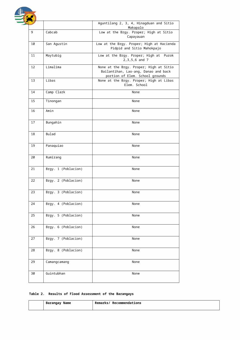
8 Riverside Moderate at the Brgy. Proper; High at Aguntilang 2, 3, 4, Hinagduan and Sitio Makapalo
9 Cabcab Low at the Brgy. Proper; High at Sitio Capayauan
10 San Agustin Low at the Brgy. Proper; High at Hacienda Pidpid and Sitio Mahokpajo
11 Maytubig Low at the Brgy. Proper; High at Purok 2,3,5,6 and 7
12 Limalima None at the Brgy. Proper; High at Sitio Bailantihan, Lao-ang, Danao and back portion of Elem. School grounds
13 Libas None at the Brgy. Proper; High at Libas Elem. School
14 Camp Clark None
15 Tinongan None
16 Amin None
17 Bungahin None
18 Bulad None
19 Panaquiao None
20 Rumirang None
21 Brgy. 1 (Poblacion) None

22 Brgy. 2 (Poblacion) None
23 Brgy. 3 (Poblacion) None
24 Brgy. 4 (Poblacion) None
25 Brgy. 5 (Poblacion) None
26 Brgy. 6 (Poblacion) None
27 Brgy. 7 (Poblacion) None
28 Brgy. 8 (Poblacion) None
29 Camangcamang None
30 Guintubhan None
Table 2. Results of Flood Assessment of the Barangays
Barangay Name Remarks/ Recommendations
1 Amin None
2 Banogbanog None
3 Brgy. 1 (Poblacion) Low flood depth of 0-0.5 m and flash flood with low turbidity are rarely experienced at the barangay.
4 Brgy. 2 (Poblacion) Low flood depth of 0-0.5 m and flash flood with low turbidity are rarely experienced at the barangay.
5 Brgy. 3 (Poblacion) Low flood depth of 0-0.5 m and flash flood with low turbidity are rarely experienced at the barangay.
6 Brgy. 4 (Poblacion) Low flood depth of 0-0.5 m and flash flood with low turbidity are rarely experienced at the barangay.
7 Brgy. 5 (Poblacion) Moderate flood depth of 0.5-1m is seasonally experienced at the barangay affecting mainly the sugarcane fields. Flash flood with high turbidity commonly occurs in the area.
8 Brgy. 6 (Poblacion) Moderate flood depth of 0.5-1m is seasonally experienced at the barangay. Flash flood with low turbidity rarely occurs in the area.
9 Brgy. 7 (Poblacion) Low flood depth of 0-0.5 m and flash flood with low turbidity are rarely experienced at the barangay.
10 Brgy. 8 (Poblacion) High flood depth of >1m is seasonally experienced at the barangay caused by insufficient drainage facility and improper garbage disposal. It takes 2 days before flood water recede.
11 Brgy. 9 (Poblacion) Moderate flood depth of 0.5-1m is seasonally experienced at the barangay caused by insufficient drainage facility and improper garbage disposal.
12 Bulad Moderate flood depth of 0.5-1m is seasonally experienced at the Brgy. Proper, Sitio Tagum-Tagum, Hacienda San Jose, Maria Antonia and Simborio.
13 Bungahin High flood depth of >1m is seasonally experienced at the barangay.
14 Cabcab High flood depth of >1m is seasonally experienced at Sitio Crossing.
15 Camangcamang High flood depth of >1m seasonally affects some portions of the plantation in the barangay.

16 Camp Clark None
17 Cansalongon Areas near the river are affected by high flood depth of >1m during heavy rains and typhoons. Moderate flood depth of 0.5-1m is experienced in some areas.
18 Guintubhan High flood depth of >1m is seasonally experienced at Haciendas Bacan and Flor caused by the overflowing of Guintobhan River.
19 Libas High flood depth of >1m is seasonally experienced at the Brgy. Proper and Purok Saging caused by the overflowing of Panaquiao River during rainy season.
20 Limalima High flood depth of >1m is seasonally experienced at Sitio Mandapipi, Lao-ang and Dumaguinding.
21 Makilignit None
22 Mansablay High flood depth of >1m is seasonally experienced at low-lying portions of the barangay. Source of flooding is runoff from upstream.
23 Maytubig Low flood depth of 0-0.5 m is rarely experienced at the barangay. Flash flood with high turbidity commonly occurs in the area.
24 Panaquiao Low flood depth of 0-0.5 m is experienced at the Brgy. Proper while high flood depth of >1m occurs in Purok 3 during rainy season.
25 Riverside High flood depth of >1m is seasonally experienced at Aguntilang 1 and 2.
26 Rumirang Low flood depth of 0-0.5 m and flash flood with low turbidity are rarely experienced at the Brgy. Proper while moderate flood depth of 0.5-1 m affects Sitio San Pedro and Calapuisan during rainy season.
27 San Agustin High flood depth of >1m is seasonally experienced at portions of the Brgy. Proper adjacent to Tinongan River.
28 Sebucawan Moderate flood depth of 0.5-1m affects Sitio Coyaoyao and portions of Brgy. Proper caused by the overflowing of an unnamed creek during rainy season.
29 Sikatuna None
30 Tinongon High flood depth of >1m is seasonally experienced at Sitio Buhian and Hacienda San Antonio caused by the overflowing of an unnamed creek during rainy season.
Kabankalan City
Table1. Results of Landslide Assessment of the barangays

Barangay Name Landslide Susceptibility Rating
1 Carol-an High
2 Tan-awan Moderate
3 Hilamonan Moderate
4 Camansi Low
5 Bantayan None at the Brgy. Proper; Low at sloping areas
6 Locotan None at the Brgy. Proper; Low at Sitio Ilang and Purok Bugtong
7 Magballo None at the Brgy. Proper; Low at Sitio Pacama
8 Tapi None at the Brgy. Proper; Low on sloping areas
9 Oringao None at the Brgy. Proper; Moderate at Upper Purok Ceresa
10 Tagukon None at the Brgy. Proper; High in Purok Lower Ballo and Purok Upper Ballo
11 Tampalon None at the Brgy. Proper; Moderate at Purok Tagaytay, Amian Ilaya Zone 1 and Purok Guibuangan
12 Pinaguinpinan None at the Brgy. Proper; High at Purok Manban
13 Inapoy None at the Brgy. Proper; High at Purok Piliopiliohan
14 Camugao None
15 Linao None
16 Brgy. 1 (Poblacion) None
17 Brgy. 2 (Poblacion) None
18 Brgy. 3 (Poblacion) None
19 Brgy. 4 (Poblacion) None
20 Brgy. 5 (Poblacion) None
21 Brgy. 6 (Poblacion) None
22 Brgy. 7 (Poblacion) None
23 Brgy. 8 (Poblacion) None
24 Brgy. 9 (Poblacion) None
25 Salong None
26 Talubangi None
27 Tagoc None
28 Tabugon None
29 Camingawan None
30 Orong None
31 Binicuil None
32 Daan Banua None
Table 2. Results of Flood Assessment of the Barangays
Barangay Name Remarks/ Recommendations
1 Bantayan High flood depth of >1m is seasonally experienced at the barangay. Roads become impassable during typhoon season. Worst case was during a typhoon in August 2009.
2 Brgy. 1 (Poblacion) High flood depth of >1m is seasonally experienced at the barangay. There were no recorded flooding events for the past 5 years. However, the worst flooding incident was during Typhoon Ruping, Nitang and Nanang.
3 Brgy. 2 (Poblacion) Moderate flood depth of 0.5-1 m is seasonally experienced at the barangay. Worst flooding event was during Typhoon Nitang.
4 Brgy. 3 (Poblacion) High flood depth of >1m is seasonally experienced at the barangay. There were no recorded flooding events for the past 5 years. However, the worst flooding incident was during Typhoon Ruping and Nitang and Nanang
5 Brgy. 4 (Poblacion) High flood depth of >1m is seasonally experienced at the barangay.
6 Brgy. 5 (Poblacion) High flood depth of >1m is seasonally experienced at the barangay. Worst case of flooding was during Typhoon Nitang, Ruping and Nanang.
7 Brgy. 6 (Poblacion) High flood depth of >1m rarely occurs. It takes 2 days before flood water subsides. Residents living near the river are evacuated in the Brgy. school and gymnasium during typhoons.
8 Brgy. 7 (Poblacion) High flood depth of >1m is seasonally experienced at the barangay. Flash flood commonly occurs. Worst flood incident was in year 1984 during Typhoon Nitang.
9 Brgy. 8 (Poblacion) High flood depth of >1m is seasonally experienced at the barangay. BDCC is active in the barangay
10 Brgy. 9 (Poblacion) High flood depth of >1m is seasonally experienced at the barangay. Brgy. hall serves as evacuation site during typhoons. BDCC is active in the barangay.
11 Binicuil High flood depth of >1m is seasonally experienced at the barangay. There were no recorded flooding events for the past 5 years. However, the worst flooding incident was during Typhoon Ruping and Nitang. situation. Activate BDCC. Attend trainings and seminars on disaster preparedness and mitigation.
12 Camansi High flood depth of >1m and flash flood with low turbidity are rarely experienced at the barangay.
13 Camingawan Low flood depth of 0-0.5 m affects ricefields near the Hilabangon River.
14 Camugao High flood depth of >1m is seasonally experienced at Sitio Patay. Whole barangay affected with high flood depth in year 1984 during Typhoon Nitang caused by the overflowing of Ilog and Hilabangan Rivers.
15 Carol-an High flood depth of >1m is experienced at Sitio Mambig near Lolosbon Lake and Sitio Dahingan during strong rainfall due to typhoon. Annual flooding in the area is caused by the lack of outlet for surface runoff.
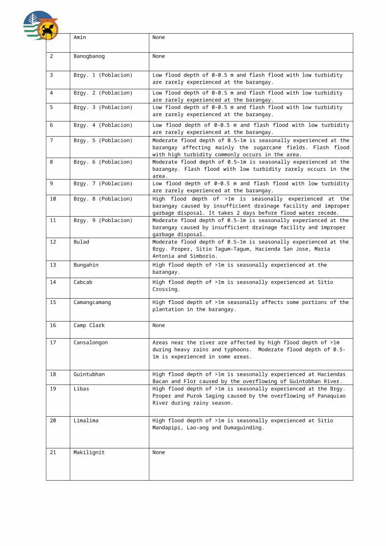
16 Daan Banua High flood depth of >1m is seasonally experienced at the barangay. There were no recorded flooding events for the past 5 years. However, the worst flooding incident was during Typhoon Ruping and Nitang.
17 Hilamonan High flood depth of >1m is seasonally experienced at Sitio Flora, Utod, Paniqui, Tunga, Pidio and Punta Taytay caused by the verflowing of Hilabangan River.
18 Inapoy High flood depth of >1m is experienced near the banks of Ilog River. Bank scouring and erosion also affects the area.
19 Linao High flood depth of >1m is seasonally experienced at Purok 1, 3, 7, 8, 9 and 10. Agricultural lands are mainly affected during high tide and when Ilog and Hilabangan Rivers overflow.
20 Locotan High flood depth of >1m is rarely experienced at the barangay. Sagumayon River becomes impassable during typhoon season. It takes 2 days before floodwaters subside.
21 Magballo High flood depth of >1m is seasonally experienced at the barangay wherein about 5 sq. km. of land area and about 10 houses can be affected.
22 Oringao Moderate flood depth of 0.5-1 m is seasonally experienced at the barangay affecting the following puroks: Taytay, Gemelina, Pine Tree, Ceresa and Tuburan. Flooding is caused by insufficient drainage system. It takes 2 hours before floodwaters subside. Riverbank erosion along Inayawan River affects Puroks Taytay, Badiangay and Cambalogo.
23 Orong High flood depth of >1m is seasonally experienced at Sitio Pandan, Sitio Balisong, Purok 4 and at the Brgy. Proper caused by the overflowing of Ilog River during rainy season.
24 Pinaguinpinan Moderate flood depth of 0.5-1 m is seasonally experienced at Purok Manban when Tablas Creek overflows during rainy season.
25 Salong Moderate flood depth of 0.5-1m is rarely experienced at the barangay caused by the overflowing of Salong River and Magayno Creek. Warning of impending flood is being done by the city government through mobile phones and megaphones. Manmade drainage facility is too small to carry the large volume of water therefore flooding low-lying areas particularly Sitio Vista Alegre.
26 Tabugon Bank scouring and erosion observed along Tabla River.
27 Tagoc High flood depth of >1m is seasonally experienced at Purok Sampaguita. Overflowing of Nasalayan River affects ricefields.
28 Tagukon Moderate flood depth of 0.5-1 m is seasonally experienced at Purok Narra caused by the overflowing of Ilog River during rainy season.
29 Talubangi High flood depth of >1m is seasonally experienced at the barangay caused by the overflowing of Ilog River during rainy season. Riverbank erosion also affects the area.
30 Tampalon High flood depth of >1m is seasonally experienced at Purok Guibuangan and Bangkal. Flooding is due to inadequate drainage system.
31 Tan-awan High flood depth of >1m is seasonally experienced at Purok 1 caused by the overflowing of Hilabangan River. Floodng is more than one week duration.
32 Tapi None

Municipality of La Castellana
Table1. Results of Landslide Assessment of the barangays
Barangay Name Landslide Susceptibility Rating
1 Cabagnaan High
2 Biak na Bato High
3 Sag-ang High
4 Mansalanao High
5 Cabacungan Moderate
6 Camandag Low at the Brgy. Proper, Moderate on foot slopes
7 Puso Low at the Brgy. Proper; Moderate on sloping portions
8 Manghanoy Low at the Brgy. Proper; Moderate on steep slopes
9 Lalagsan Low
10 Talaptap Low
11 Nato Low
12 Robles (Poblacion) None
13 Masulog None
Table 2. Results of Flood Assessment of the Barangays
Barangay Name Remarks/ Recommendations
1 Biak na Bato Bank scouring along Ibid River affects Sitio Tinago and Luho.
2 Cabacungan Moderate flood depth of 0.5-1m is seasonally experienced at Sitio Tikoytikoy. A house was washed out during a typhoon in year 2009. The livestock of some residents and their farmlands were also affected by flood.
3 Cabagnaan Low flood depth of 0-0.5 m and flashflood with low turbidity are rarely experienced at Old Fabrica due to the obstruction of drainage system and overflowing of Talaptap Creek.

4 Camandag Low flood depth of 0-0.5 m is seasonally experienced at the barangay caused by the overflowing of Camandag Proper spillway. Flooding affects agricultural lands.
5 Lalagsan Low flood depth of 0-0.5 m and flashflood with low turbidity are rarely experienced at the Brgy. Proper while moderate flood depth of 0.5-1m affects Purok Narra, Ipil-ipil and Mangga.
6 Manghanoy Moderate flood depth of 0.5-1m is seasonally experienced at Sitio Baraguas, Manghanoy Proper and portion of Apolonia. Flooding affects farmlands and some houses.
7 Mansalanao High flood depth of >1m is seasonally experienced at Purok Langka and Narra (Proper) caused by the overflowing of Odiong River.
8 Masulog Moderate flood depth of 0.5-1m is seasonally experienced at the barangay caused by the overflowing of Masulog and Mambuto Rivers. Flash flood with low turbidity commonly occurs in the area.
9 Nato Low flood depth of 0-0.5 m and flashflood with low turbidity are rarely experienced at the barangay.
10 Puso None
11 Robles (Poblacion) Low flood depth of 0-0.5 m and flash flood with low turbidity are rarely experienced at the Brgy. Proper. High flood depth of >1m affects houses and farmlands at Bonifacio Extension along Induruyan and Buhangin Rivers. Flash flood with high turbidity also commonly occurs in the area.
12 Sag-ang Flash flood commonly affects the following areas: Conchita, Coscouella, Lapak, Canlaon 3, Isabel and portion of San Luis. Bank scouring and erosion along Sag-ang River affects Sitio Treseles, Purok Paglaum and Sitio Fermar.
13 Talaptap Low flood depth of 0-0.5 m and flashflood with low turbidity are rarely experienced at the barangay.
La Carlota City
Table1. Results of Landslide Assessment of the barangays
Barangay Name Landslide Susceptibility Rating
1 Ara-al Moderate at the Brgy. Proper; High in Sitio Mansibanga, Purok Santan and Orchids
2 Yubo Moderate at the Brgy. Proper; High at Sitio Batacon and Bais
3 La Granja Low
4 Haguimit None at the Brgy. Proper; Moderate on slopes
5 Nagasi None
6 San Miguel None
7 Balabag None

8 R. S. Benedicto None
9 Batuan None
10 Cubay None
11 Ayungon None
12 Brgy 1 (Poblacion) None
13 Brgy. 2 (Poblacion) None
14 Brgy. 3 (Poblacion) None
Table 2. Results of Flood Assessment of the Barangays
Barangay Name Remarks/ Recommendations
1 Ara-al None
2 Ayungon High flood depth of >1m at Sitio Bucruz Dacu affects areas adjacent the river.
3 Balabag High flood depth of >1m affects areas near the Intobayan River at Hacienda Remedios during typhoon season and heavy rainfall.
4 Batuan is seasonally experienced at Hacienda Purisima caused by the overflowing of river bounding the Hacienda proper. Worst flooding incident recorded was during Typhoon Ondoy in 2009.
High flood depth also occurs at Purok Riverside caused by overflow of water discharge from upstream.
Likewise, some portions of Relocation Site Paet experience high flood depth of >1m due to overflow of river. Residents were rescued to higher grounds during typhoon Ondoy.
5 Brgy. 1 (Poblacion) Moderate flood depth of 0.5-1m is seasonally experienced at the barangay caused by clogged drainage system.
6 Brgy. 2 (Poblacion) Bucruz Gamay and Zone 8 are adversely affected by high flood depth of >1m due to overflow of rivers and creeks bounding these areas.
7 Brgy. 3 (Poblacion) When the sea level rise and floodwaters coincide, high flood depth of >1m submerges Caridad Subdivision and portions of Purok Mabinoligon, particulary those bounded by rivers and creeks.
8 Cubay Masville is flooded due to the excessive surface run-off coming from the slopes bounding the area. Moderate flood depth of 0.5-1m caused by insufficient drainage canal affects 10 households in the area. During Typhoon Senyang, high flood depth of >1m affected about 15 houses at Hacienda Alejandria caused by the overflowing of Nahalinan River. and seminars on disaster preparedness and mitigation.
9 Haguimit Flash flood during Typhoon Ruping resulted to 3 casualties and affected Sitio Masulog, Lupa and Purok Riverside near the Nahalinan River. High flood depth of >1m affects about 25 households at Sitio Danao during rainy season.
10 La Granja Moderate flood depth of 0.5-1m affects areas near Najalin River such as Purok 1, 2, 4, 7, 12, 13, 14, 16 and 19. Brgy. Proper is flooded only during typhoons and heavy rains. About 36 households were affected during Typhoon Undang.

11 Nagasi Moderate flood depth of 0.5-1m is seasonally experienced at Purok 3 affecting about 3 houses. Area is low-lying and located near a creek coming from La Granja.
12 R. S. Benedicto Low flood depth of 0-0.5 m is seasonally experienced infront of the Brgy. Hall due to insufficient drainage system. High flood depth of >1m occurs at Purok Santan caused by the overflowing of Candaguit River. It takes 1 week before floodwaters subside.
13 San Miguel High flood depth of >1m affects areas located near the riverbanks such as Hacienda San Miguel, Purok 6, Purok Crotons and portions of Brgy. Proper. Floodwaters emanate from Najalin River.
14 Yubo None
Municipality of Manapla
Table1. Results of Landslide Assessment of the barangays
Barangay Name Landslide Susceptibility Rating
1 San Pablo Low
2 Purisima Low
3 Sta. Teresa None at the Brgy. Proper; Low on sloping areas
4 Brgy. 1-B (Poblacion) None at the Brgy. Proper; Low on sloping areas
5 Chambery None
6 Brgy. 1 (Poblacion) None
7 Brgy. 1-A (Poblacion) None
8 Brgy. 2 (Poblacion) None
9 Brgy. 2-A (Poblacion) None
10 Punta Salong None
11 Tortosa None
12 Punta Mesa None
Table 2. Results of Flood Assessment of the Barangays

Barangay Name Remarks/ Recommendations
1 Brgy. 1 (Poblacion) Low flood depth of 0-0.5 m rarely occurs at the barangay. Riverbank erosion along Manapla River affects approximately 8 households at Sitio Patio.
2 Brgy. 1-A (Poblacion) High flood depth of >1m affects approximately 30% of the total population of the barangay during typhoons and heavy rains. The barangay is a catch basin of floodwaters emanating from an unnamed creek. Coastal flooding also affects the area. Flash flood with high turbidity rarely occurs.
3 Brgy. 1-B (Poblacion) Low flood depth of 0-0.5m is seasonally experienced at the barangay. Portion of Purok 6 is a catch basin of run-off from sloping areas. The barangay is also prone to coastal hazards.
4 Brgy. 2 (Poblacion) Low flood depth of 0-0.5 m affects the barangay when high tide coincides with heavy downpour of rain.
5 Brgy. 2-A (Poblacion) High flood depth of >1m affects Zone 3 (Brgy. Proper) when high tide coincides with heavy downpour of rain. During Typhoon Frank, approximately 7 households in Zone 3 and 2 households in Zone 4 were adversely affected. Storm surge also affects the area during rainy season.
6 Chambery Low flood depth of 0-0.5 m is rarely experienced at the barangay caused by the overflowing of nearby Binong and Guisok Rivers. Construction of the breakwaters and seawall mitigated the effects of coastal erosion at Puroks 2 and 4.
7 Punta Mesa Moderate flood depth of Tinihaban River is seasonally experienced at Hacienda Gaston. Storm surge affects the Brgy. Hall and Sitio Gutosan. Coastal erosion is active in the area.
8 Punta Salong Overflowing of Punta Salong River causes moderate flood depth of 0.5-1m at the barangay during rainy season. Constructed breakwaters lessened flooding in the area. The following coastal sitios are commonly affected by storm surge during Northeast monsoon rains (Amihan): Anahaw, Roadside, Cubay, Proper, Binanongnang and Balolan. In year 2003, approximately 11 houses were terribly affected.
9 Purisima High flood depth of >1m rarely occurs at the barangay. A flash flood event along Sicaba River during a typhoon in year 1995 affected the entire barangay. Flash flooding was caused by an artificial damming upstream. Riverbank erosion was also noted along the Sicaba River.
10 San Pablo High flood depth of >1m affects about 21 haciendas during typhoons and continuous heavy rains. During Typhoon Ondoy and Pepeng (2009), livestock and houses of the residents are badly affected due to the overflowing of Quinaroyan River. The following are the identified flood prone areas: Haciendas Quinaroyan, Rosa, Lourdes, Mirian, Maria, Cristina, Rita, Cambugao I & II, Sto. Domingo, Pura, Builders, Tiliang I,II & III, Ilian and Cabayao.
11 Sta. Teresa Low flood depth of 0-0.5m is seasonally experienced at the barangay. Hacienda Lina is affected by flooding during rainy season due to the overflowing of Sta. Teresa Creek.

12 Tortosa Low flood depth of 0-0.5 rarely affects the barangay during typhoons and rainy season. Coastal erosion affects Sitio Agtungtong wherein approximately 50 houses are at risk when erosion progresses. Storm surge also affects the area. Construction of the seawall lessened flooding in the barangay.
Municipality of Moises Padilla
Table1. Results of Landslide Assessment of the barangays
Barangay Name Landslide Susceptibility Rating
1 Quintin Remo Low
2 Macagahay Low at the Brgy. Proper; High at Sitio Hagogolo
3 Montilla Low
4 Guinpana-an Low
5 Inolingan Low at the Brgy. Proper; High at Upper/Lower Cuyayao and at Lower Inolingan
6 Brgy. 1 (Poblacion) None
7 Brgy. 2 (Poblacion) None
8 Brgy. 3 (Poblacion) None
9 Brgy. 4 (Poblacion) None
10 Brgy. 5 (Poblacion) None
11 Brgy. 6 (Poblacion) None
12 Brgy. 7 (Poblacion) None
13 Odiong None
14 Magallon Cadre None
15 Crossing Magallon None
Table 2. Results of Flood Assessment of the Barangays
Barangay Name Remarks/ Recommendations
1 Brgy. 1 (Poblacion) High flood depth of >1m is seasonally experienced at the barangay caused by the overflowing of Binalbagan River. Approximately 12 houses were affected by flood during Typhoon Ondoy.
2 Brgy. 2 (Poblacion) Low flood depth of 0-0.5 m and flashflood with low turbidity are rarely experienced at the barangay. No alarming flooding incident.

3 Brgy. 3 (Poblacion) Low flood depth of 0-0.5 m and flashflood with low turbidity are rarely experienced at the barangay.
4 Brgy. 4 (Poblacion) Low flood depth of 0-0.5 m and flashflood with low turbidity are rarely experienced at the barangay. No alarming flooding incident.
5 Brgy. 5 (Poblacion) Low flood depth of 0-0.5 m and flashflood with low turbidity are rarely experienced at the barangay.No alarming flooding incident.
6 Brgy. 6 (Poblacion) High flood depth of >1m is seasonally experienced at the barangay. Floodwaters come from Brgy. Magallon Cadre, Sitio Canamo and probably caused by the unfinished NIA project in the area.
7 Brgy. 7 (Poblacion) Low flood depth of 0-0.5 m and flashflood with low turbidity are rarely experienced at the barangay. No alarming flooding incident.
8 Crossing Magallon Oveflowing of Binalbagan River affects about 30 households at Hacienda Pilar and Soledad.
9 Guinpana-an Low flood depth of >0-0.5m is seasonally experienced at the barangay. Cottages in a resort in Intigiwan were swept away by floods during Typhoon Ondoy. Houses along riverbank of Cabacungan River are prone to flash flood and flooding. Farmlands along Binalbagan River are also prone to flooding.
10 Inolingan High flood depth of >1m is seasonally experienced at portions of Sitios Tuco, Silapid and Dresden located near the banks of Binalbagan and Panaqusa Rivers. Flash flood with high turbidity commonly occurs in the area.
11 Macagahay Flash flood with high turbidity commonly occurs in the area.
12 Magallon Cadre High flood depth of >1m is seasonally experienced at Hacienda Sitio Jocson. Residents affected by flooding were already relocated. Maghanoy and Balogo Creeks overflow during rainy season.
13 Montilla Flash flood with high turbidity commonly occurs in the area. Binalbagan River is prone to flash flooding due to landslide damming in Sitio Manaol (part of Purok Langka) affecting mostly ricefields.
14 Odiong High flood depth of >1m is seasonally experienced at the barangay caused by the overflowing of Odiong Creek and Buhangin River. Flooding affects mainly the agricultural lands. Active bank scouring and denudation also observed along Buhangin River.
15 Quintin Remo High flood depth of >1m affects about 15 households, ricefield and sugarcane plantation at Sitio Palaypay, Buenavista, Bonbon and Upper Lemnito. Areas upstream of Manaul Creek will be flooded if the landslide debris is not cleared from this area.
Municipality of Murcia
Table1. Results of Landslide Assessment of the barangays
Barangay Name Landslide Susceptibility Rating
1 Canlandog High
2 Pandanon High
3 Minoyan Low at the Brgy. Proper; Moderate on slopes

4 Sta. Cruz None at the Brgy. Proper; Moderate at Puroks Bug-as and Igkalayo
5 Buenavista None at the Brgy. Proper; Moderate at Sitio Anangi
6 Amayco None at the Brgy. Proper; High at Upper Batuhon
7 Sta. Rosa None
8 Abo-abo None
9 Alegria None
10 Blumentritt None
11 Caliban None
12 Cansilayan None
13 Damsite None
14 Iglau-an None
15 Lopez Jaena None
16 Salvacion None
17 San Miguel None
18 Talotog None
19 Zone 1 (Poblacion) None
20 Zone 2 (Poblacion) None
21 Zone 3 (Poblacion) None
22 Zone 4 (Poblacion) None
23 Zone 5 (Poblacion) None
Table 2. Results of Flood Assessment of the Barangays
Barangay Name Remarks/ Recommendations
1 Abo-abo High flood depth of >1m is seasonally experienced at the barangay caused by the overflowing of a creek. Small culvert and indiscriminate dumping of waste materials aggravates flooding in the area.
2 Alegria None
3 Amayco High flood depth of >1m is seasonally experienced at Puroks Minuro, Kalubihan and Katumbal. Flash flood with moderate turbidity is also common in the area.
4 Blumentritt None
5 Buenavista None

6 Caliban None
7 Canlandog High flood depth of >1m rarely occurs. During a typhoon in year 1996, flood affected the Brgy. Proper, MaryI and Jalandumon. 2 houses were washed away during that flooding event.
8 Cansilayan Flash flood incident during a typhoon in year 1993 led to 6 casualties due to drowning near Cansilayan River. Two houses were also affected.
9 Damsite High flood depth of >1m is seasonally experienced at Sitio Intorilan. Riverine flooding during typhoons and heavy rains of a tributary of Bago River affects approximately 10 families in the area. Moderate flood depth of 0.5-1 m also occurs at Damsite Proper during heavy rains affecting about 5 houses.
10 Iglau-an None
11 Lopez Jaena None
12 Minoyan None
13 Pandanon None
14 Salvacion Moderate flood depth of 0.5-1 m is seasonally experienced at Smile Village. During Typhoon Frank, Purok Linasan was partly underwater due to overflow of a creek.
15 San Miguel Riverbank erosion along Asia and Pula Rivers affect Purok Orchids.
16 Sta. Cruz None
17 Santa Rosa None
18 Talotog None
19 Zone 1 (Poblacion) Low flood depth of 0-0.5 m is seasonally experienced at Puroks Sambag and Caimito affecting about 10 households along Langub Creek.
20 Zone 2 (Poblacion) None
21 Zone 3 (Poblacion) Drainage-related flooding affects a private property at Purok Malunggay. Flooding also affects Purok Kamatis.
22 Zone 4 (Poblacion) None
23 Zone 5 (Poblacion) None
Municipality of Pontevedra
Table1. Results of Landslide Assessment of the barangays
Barangay Name Landslide Susceptibility Rating
1 Gomez High
2 Burgos High
3 Zamora Moderate
4 General Malvar Low
5 Cambarus Low
6 Pandan Low

7 Antipolo Low
8 Buenavista Rizal None
9 Mabini None
10 Don Salvador Benedicto None
11 Brgy. 1 (Poblacion) None
12 Brgy. 2 (Poblacion) None
13 Brgy. 3 (Poblacion) None
14 San Juan None
15 M. H. Del Pilar None
16 Buenavista Gibong None
17 Miranda None
18 Recreo None
19 Canroma None
20 San Isidro None
Table 2. Results of Flood Assessment of the Barangays
Barangay Name Remarks/ Recommendations
1 Antipolo Low flood depth of 0-0.5 m and flash flood with low turbidity are rarely experienced at the barangay.
2 Brgy. 1 (Poblacion) Moderate flood depth of 0.5-1m rarely occurs in the area.
3 Brgy. 2 (Poblacion) Low flood depth of 0-0.5 m rarely occurs at the barangay. Overflowing of Marayo River affects areas adjacent to the river.
4 Brgy. 3 (Poblacion) High flood depth of >1m is seasonally experienced at areas along the coast especially when high tide level coincides with the overflow of flood waters along river systems. Low flood depth of 0-0.5 is experienced at the Brgy. Proper.
5 Buenavista Gibong None
6 Buenavista Rizal None
7 Burgos High flood depth of >1m is seasonally experienced at Purok 2 wherein 8 houses located near the riverbanks can be affected.
8 Cambarus Low flood depth of 0-0.5 m and flash flood with low turbidity are rarely experienced at the barangay.
9 Canroma Low flood depth of 0-0.5 m is seasonally experienced at Purok Kapayas and Punong due to insufficient drainage system.
10 Don Salvador Benedicto High flood depth of >1m rarely occurs. Worst flooding incident happened during Typhoon Ruping.
11 General Malvar Low flood depth of 0-0.5 m and flash flood with low turbidity are rarely experienced at the Brgy. Proper. High flood depth of >1m is seasonally experienced at Purok 1.
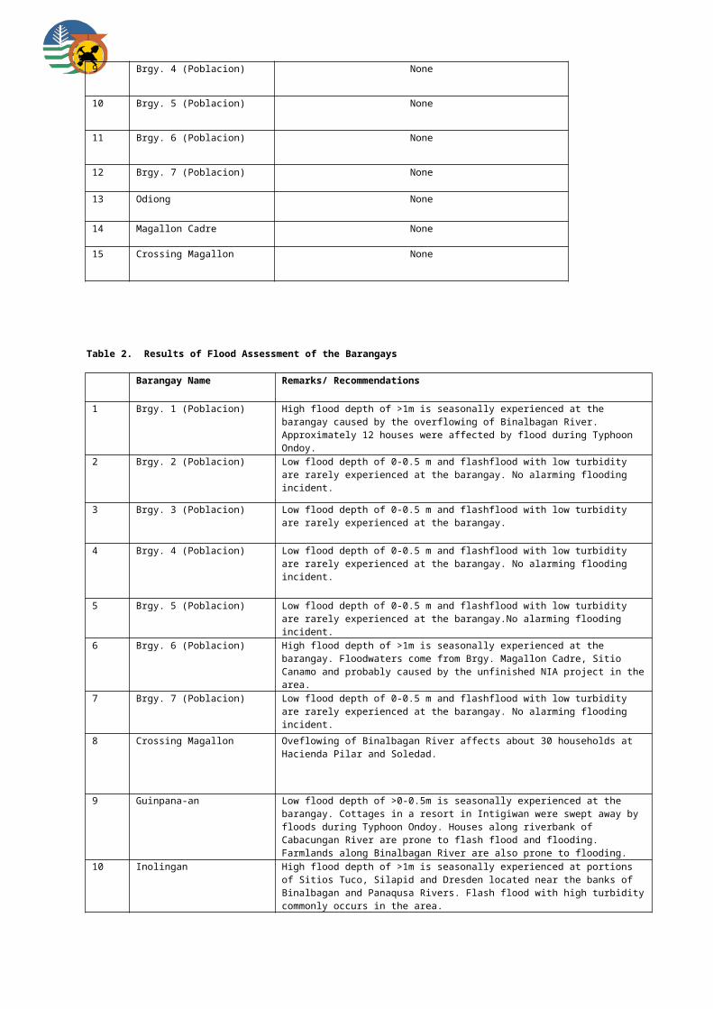
12 Gomez High flood depth of >1m is seasonally experienced at the barangay caused by the overflowing of Quiput River.
13 M. H. Del PIlar None
14 Mabini Moderate flood depth of 0.5-1m is seasonally experienced at Purok 3 affecting 5 houses located near the Marayo River.
15 Miranda None
16 Pandan Low flood depth of 0-0.5 m and flash flood with low turbidity are rarely experienced at the barangay.
17 Recreo Moderate flood depth of 0.5-1m is seasonally experienced at Purok 4 caused by the overflowing of an unnamed creek. Flood waters subside after 3 days.
18 San Isidro Low flood depth of 0-0.5 m and flash flood with low turbidity are rarely experienced at the Brgy. Proper. Moderate flood depth of 0.5-1m is seasonally experienced at Sitio Cabog and Cadena de Amor.
19 San Juan High flood depth of >1m rarely occurs. The worst flooding the hit the area was when a dam was destroyed and contributed a big volume of flood water in the barangay. Fishponds were likewise destroyed.
20 Zamora Low flood depth of 0-0.5 m is seasonally experienced at the barangay. Bank scouring/erosion is also noted along Camansi River.
Municipality of Pulupandan
Table 2. Results of Flood Assessment of the Barangays
Barangay Name Remarks/ Recommendations
1 Brgy. Zone 1 (Poblacion) Low flood depth of 0-0.5 m and flashflood with low turbidity rarely occur at the barangay. Construction of drainage facility has addressed the problem of flooding in the area. Coastal flooding affects about 20 households along the coast.
2 Brgy. Zone 1-A (Poblacion) Low flood depth of 0-0.5 m seasonally occurs in the area due to inadequate drainage system. Storm surge and coastal erosion affect areas near the coast.
3 Brgy. Zone 2 (Poblacion) Low flood depth of 0-0.5 m and flashflood with low turbidity rarely occur at the barangay. Improvement of drainage facility has addressed the problem of flooding in the area.
4 Brgy. Zone 3 (Poblacion) Construction of appropriate drainage system prevented flooding in the area. A very high seawall was also constructed to mitigate effects of storm surge in areas near the coast.
5 Brgy. Zone 4 (Poblacion) Low flood depth of 0-0.5 m rarely occurs at the Brgy. Proper. Moderate flood depth of 0.5-1 m seasonally affects portion of Purok Sampaguita and Gumamela during rainy season.
6 Brgy. Zone 4-A (Poblacion) Low flood depth of 0-0.5 m rarely occurs at the Brgy. Proper. High flood depth of >1m seasonally affects farmlands of Purok Core Shelter.
7 Brgy. Zone 5 (Poblacion) Low flood depth of 0-0.5 m is seasonally experienced at the barangay. Flash flood with low turbidity rarely occurs.
8 Brgy. Zone 6 (Poblacion) Moderate flood depth of 0.5-1m is seasonally experienced at the barangay. Floodwaters easily subside after the rain.
9 Brgy. Zone 7 (Poblacion) Low flood depth of 0-0.5 m rarely occurs at the Brgy. Proper. Moderate flood depth of 0.5-1m affects Purok Kaymito and Santol during rainy season. Flash flood with low turbidity rarely occurs in the area.
10 Canjusa High surface run-off and high tide causes low flood depth of 0-0.5 m in the following areas: Purok Malinong, Maglaum 1 & 2, Paguidait and Bacao.
11 Crossing Pulupandan Low flood depth of 0-0.5 m seasonally affects Sitio Molave. Overflowing of irrigation

canal causes flooding in the area before. Observe effectiveness of concreted dike during rainy season.
12 Culo Low flood depth of 0-0.5 m affects Sitio Cadaoan while moderate flood depth of 0.5-1m affects Purok Binoligon. Floodwaters emanate from Bago River..
13 Mabini Low flood depth of 0-0.5 m seasonally occurs. Storm surge also affects the areas near the coast during rainy season.
14 Pag-ayon Low flood depth of 0-0.5 m seasonally affects the Brgy. Proper, Purok Santan and Cabique while moderate flood depth of 0.5-1 m affects Purok Pandan. Floodwaters emanate from Bago River.
15 Palaka Norte Low flood depth of 0-0.5 m and flashflood with low turbidity rarely occur at the barangay.
16 Palaka Sur Barangay is located near the coast. Coastal hazards affecting the area include storm surge, coastal erosion and saltwater intrusion.
17 Patic Low flood depth of 0-0.5 m seasonally occurs caused by high tide and heavy downpour of rains. Puroks affected include Mabinuligon, Mayguba, Paghidait, Kalubihan, Punta Bagul and Mahigugma-on. Storm surge and coastal flooding also affect he area.
18 Tapong Low flood depth of 0-0.5 m seasonally affects Sitio Cavan due to high tide and river flooding.
19 Ubay Moderate flood depth of 0.5-1m commonly occurs when high tide and bankful discharge from Bago River merges at the mouth or estuary of this large river. It affects Purok Lag-asan 2 and 3, Pantalan and Kramer during heavy rains and typhoons.
20 Utod Low flood depth of 0-0.5 m seasonally occurs affecting Purok Mapisan and Malipayon. Purok Madinumdumon is prone to coastal flooding and storm surge. Approximately 90 houses located near the coast can be affected by coastal erosion.
Sagay City
Table1. Results of Landslide Assessment of the barangays
Barangay Name Landslide Susceptibility Rating
1 Colonia Divinia Low at barangay proper; but high at Purok Balabag, Hantikon and Manipulon
2 Puey Low at barangay; proper; proper; but high at Puroks Cabungahan and Manarra
3 Maquiling Low at barangay proper; but high at Puroks Maalwan, Calubihan and Mabindigon
4 Baviera Low at barangay proper; but high at Purok Silica
5 Sewahon-1 Low at barangay proper; high at Zones 11, 12, 16 and 18.
6 Bato Low at barangay proper; but moderate at Purok Bagong Silang
7 Lopez Jaena Low at barangay proper; but high at Puroks Pula and Germelina
8 Rizal Low at barangay proper
9 Plaridel Low at barangay proper

10 Andres Bonifacio Low at barangay proper
11 Bulanon Low at barangay proper
12 Vito Low at barangay proper
13 Fabrica None at barangay proper; but moderate at Puroks Mahigugma-on and United
14 Tadlong None
15 Himoga-an Baybay None
16 Maluban None
17 Paraiso None
18 Campo Himoga-an None
19 Gen. Luna None
20 Rafaela Barrera None
21 Poblacion 1 None
22 Old Sagay None
23 Molocaboc None
24 Taba-ao None
25 Poblacion 2 None
Table 2. Results of Flood Assessment of the Barangays
Barangay Name Remarks/ Recommendations
1 Colonia Divinia Low flood depth of 0-0.5 m is seasonally experienced at the Brgy. Proper.
2 Puey Low flood depth of 0-0.5 m is seasonally experienced at the Brgy. Proper.
3 Maquiling Low flood depth of 0-0.5 m is seasonally experienced at the Brgy. Proper.
4 Baviera Low flood depth of 0-0.5 m is seasonally experienced at the Brgy. Proper.
5 Sewahon-1 Low flood depth of 0-0.5 m is seasonally experienced at the Brgy. Proper.
6 Bato Low flood depth of 0-0.5 m is seasonally experienced at the Brgy. Proper.

7 Lopez Jaena Low flood depth of 0-0.5 m is seasonally experienced at the Brgy. Proper.
8 Rizal Low flood depth of 0-0.5 m is seasonally experienced at the Brgy. Proper.
9 Plaridel Low flood depth of 0-0.5 m is seasonally experienced at the Brgy. Proper.
10 Andres Bonifacio Low flood depth of 0-0.5 m is seasonally experienced at the Brgy. Proper.
11 Bulanon Low flood depth of 0-0.5 m is seasonally experienced at the Brgy. Proper.
12 Vito Low flood depth of 0-0.5 m is seasonally experienced at the Brgy. Proper.
13 Fabrica Flashfloods in 1960 & 1964 affected Puroks Sto. Nino, San Juan, Mahigugma-on, Mabuhay and Riverhillside. These areas are drained by Himoga-an River and are seasonally affected by sheet flooding.
14 Tadlong None
15 Himoga-an Baybay None; but storm surge and coastal erosion are evident in Sitios Sawmill, Balunggay, Tapon and Pandanan
16 Malubon None
17 Paraiso High flood depth of >1m is observed at the barangay proper and in Puroks San Agustin, Maydaiton and Pagay. These areas lie adjacent to the Himoga-an River, and flash-flooding is also noted in these areas.
18 Campo Himoga-an High flood depth of >1m is observed at Purok Riverside, adjacent to Hinamog-an River and at Puroks Air Raid and Purok Laiza, which are situated near an unnamed creek. These areas are seasonally affected by floods. In Purok Edano river erosion is very evident.
19 Gen. Luna None
20 Rafaela Barrera Low flood depth of 0-0.5 m is seasonally experienced at the Brgy. Proper.
21 Poblacion 1 Moderate flooding (0.5-1 m. depth) is noted in Purok 3 due to insufficient drainage system in this highly paved developed area.
22 Old Sagay Purok Manzanilla is seasonally affected by sheet flooding (>1m. depth). While moderate flooding with 0.5 to 1 meter depth in the Brgy. Proper is noted. Storm surges normally affects the coastal areas of the Brgy.
23 Molocaboc Low flood depth of 0-0.5 m is seasonally experienced at the Brgy. Proper. However, storm surge normally affects the areas near the shore, particularly during typhoon season. In June 2008, Typhoon Frank damaged 168 houses and 19 casualties was recorded.
24 Taba-ao Puroks affected by sheet flooding (1 m depths) are Purok Punta Roma, Purok Proper and Gasang. Kinalumsan River is the major river draining the Brgy. and is normally the source of flooding particularly during the rainy seasons. Storm surges regularly affects the coastal areas.
25 Poblacion 2 Sheet flooding (>1 m. depths) were recorded in Puroks Malipayon and Matakay, these areas lie adjacent to the Tan-ao River. In Puroks Croton And Jison the occurrence of flooding is reduced due to improved drainage system.
San Carlos City
Table1. Results of Landslide Assessment of the barangays
Barangay Name Landslide Susceptibility Rating
1 Rizal High
2 Nataban Moderate

3 Codcod Moderate at the Brgy. Proper; High at Sitio Gabi-gabi, Purok Apog-apog and Sitio Napaturan
4 Quezon Moderate at the Brgy. Proper, Sitios Taptapan, Burlad and Sibatsi
5 Palampas Low at the Brgy. Proper; Moderate on slopes nearby
6 Bagonbon Low at the Brgy. Proper; Moderate on slopes nearby
7 Punao None at the Brgy. Proper; Moderate on slopes nearby
8 Prosperidad None at the Brgy. Proper; Moderate along road cuts in Sitio Ulay
9 Guadalupe None at the Brgy. Proper; Moderate on steep slopes of the barangay
10 Buluangan None at the Brgy. Proper; Moderate in sloping areas
11 San Juan None
12 Ermita None
13 Brgy. 1 (Poblacion) None
14 Brgy. 2 (Poblacion) None
15 Brgy. 3 (Poblacion) None
16 Brgy. 4 (Poblacion) None
17 Brgy. 5 (Poblacion) None
18 Brgy. 6 (Poblacion) None
Table 2. Results of Flood Assessment of the Barangays
Barangay Name Remarks/ Recommendations
1 Bagonbon None
2 Brgy. 1 (Poblacion) High flood depth of >1m seasonally affects Puroks Tindalo, Lubi and Gemelina caused by simultaneous occurrence of high tide and riverine flooding. Frequent flooding in the area is also caused by inadequate drainage system and clogged canals. Brgy. Proper is affected by storm surge and coastal flooding during typhoons.
3 Brgy. 2 (Poblacion) No flooding incident recorded in the past.
4 Brgy. 3 (Poblacion) Low flood depth of 0-0.5 m affects Zone 6 (Dos Hermanos).
5 Brgy. 4 (Poblacion) Low flood depth of 0-0.5 m and flashflood with low turbidity rarely occur at the barangay. No alarming flooding incident.
6 Brgy. 5 (Poblacion) No flooding incident recorded in the past.
7 Brgy. 6 (Poblacion) Low flood depth of 0-0.5 m and flashflood with low turbidity rarely occur at the barangay.
8 Buluangan Low flood depth of 0-0.5 m seasonally occurs at the barangay. Sugarcane plantations of Sitio Katingal-an is affected by short term flooding while backflow during high tide and excessive surface runoff cause flooding at Sitio Fortuna also affecting the crops.

Approximately 10 households on the banks of Buluangan River experience flooding at Sitio Lawis.
9 Codcod Low flood depth of 0-0.5 m rarely occurs at the barangay. Flash flood with high turbidity commonly affects Sitio Initihan near Nagalaw River.
10 Ermita Moderate flooding with depth of 0.5-1m is experienced by the barangay caused by rise in sea level during the months of April to June.
11 Guadalupe High flood depth of >1m affects Sitios Tal-ot, Higalaman and Abugan. More than 100 houses on the riverbanks are inundated causing damages to their livestock and properties. A flash flood incident in years 1987 and 2002 washed out about 50 houses at Sitio Cabugan.
12 Nataban Low flood depth of 0-0.5 m seasonally affects Sitio Tagda.
13 Palampas High flood depth of >1m rarely occurs at the barangay. Worst flooding incident was during Typhoon Ruping wherein Sitio Manga was affected due to the overflowing of Palampas River.
14 Prosperidad None
15 Punao High flood depth of >1m affects Sitios Maloloy-on, Riverside, Pasil and Kanipa-an during continuous heavy rains. These areas are situated along the junction of Talave River and Tongo Creek. Approximately 416 households can be affected. Worst flooding incident was during Typhoons Ruping and Nitang.
16 Quezon Low flood depth of 0-0.5 m rarely occurs at the barangay. Flash flood with high turbidity commonly affects Sitios Nabutahan, Initihan and Igtutuboy.
17 Rizal Moderate flood depth of 0.5-1m seasonally affects Sitio Medina and Rizal Proper during typhoons and heavy rains. Approximately 15 families are heavily affected at Sitio Medina. Frequent flooding is caused by the overflowing of Anduon River. To address the problem, riprap structure was built.
18 San Juan None
Municipality of Salvador Benedicto
Table1. Results of Landslide Assessment of the barangays
Barangay Name Landslide Susceptibility Rating
1 Pinowayan High
2 Bago High
3 Bagong Silang High
4 Bunga Moderate
5 Igmaya-an Moderate
6 Kumaliskis Moderate
7 Pandanon Moderate
Table 2. Results of Flood Assessment of the Barangays
Barangay Name Remarks/ Recommendations

1 Bago High flood depth of >1m is seasonally experienced at the barangay. 3 houses were damaged during a typhoon due to flood. Sitio Alidahawan and the barangay proper are prone to flash flood.
2 Bagong Silang An episode of flash flood resulted to 1 casualty at Sitio Dahunan. The school at the Brgy. Proper was also affected by flash flood in year 2009. High flood depth >1m and flash flood with high turbidity commonly affects the barangay.
3 Bunga High flood depth of >1m is rarely experienced at the barangay affecting mainly the farmlands.
4 Igmaya-an Low flood depth of 0-0.5m is rarely experienced at the barangay. Sitio Talos can be affected by flood during typhoons and heavy rains.
5 Kumaliskis Flooding at Sitios Mambaran, Nabugla and Sibalan affects the agicultural lands.
6 Pandanon Low flood depth of 0-0.5m affects the roadsides of the barangay during rainy season.
7 Pinowayan High flood depth of >1m is seasonally experienced at Puroks Riverside and Malinawon. Riverbank erosion also affects Purok Riverside. Flash flood along Kinopuyan River in October 2008 resulted to 6 casualties.
Municipality of San Enrique
Table 2. Results of Flood Assessment of the Barangays
Barangay Name Remarks/ Recommendations
1 Bagonawa High flood depth of >1m is seasonally experienced at the barangay. Flash flood with moderate turbidity is common in the area.
2 Baliwagan High flood depth of >1m is seasonally experienced at the barangay. Flash flood with moderate turbidity is common in the area.
3 Batuan Low flood depth of 0-0.5m affects the roads during rainy season.
4 Guintorilan High flood depth of >1m occurs due to high tide and overflowing of Bago River and irrigation canals. Flooding worsens because the water could not flow towards the sea.
5 Nayon High flood depth of >1m occurs due to high tide. Flash flood with moderate turbidity is common in the area.
6 Poblacion High flood depth of >1m is seasonally experienced at the barangay. Flash flood with moderate turbidity is common in the area.
7 Sibucao High flood depth of >1m is seasonally experienced at the barangay. Flash flood with moderate turbidity is common in the area. gement training for barangay officials and residents.
8 Tabao Baybay Low flood depth of 0-0.5m affects Purok Bantud and the National High School.
9 Tabao Rizal High flood depth of >1m is seasonally experienced in areas near the irrigation canals.
10 Tibsok High flood depth of >1m is seasonally experienced at the barangay. Flash flood with moderate turbidity commonly occurs. Storm surge and erosion also affects the coastal areas.
Silay City
Table1. Results of Landslide Assessment of the barangays

Barangay Name Landslide Susceptibility Rating
1 Patag High
2 Capt. Ramon Low
3 Poblacion 1 None
4 Poblacion 2 None
5 Poblacion 3 None
6 Poblacion 4 None
7 Poblacion 5 None
8 Poblacion 6 (Hawaiian) None
9 Bagtic None
10 Balaring None
11 Eustaquio Lopez None
12 Guimbalaon None
13 Guinhalaran None
14 Lantad None
15 Mambulac None
16 Rizal None
Table 2. Results of Flood Assessment of the Barangays
Barangay Name Remarks/ Recommendations
1 Poblacion 1 High flood depth of >1 m seasonally occurs in this barangay. Flashflood with moderate turbidity rarely occurs. Previous flooding episodes have affected 60 households. Some portions of this barangay are at risk from coastal flooding and storm surge.
2 Poblacion 2 High flood depth of >1 m seasonally occurs in this barangay. Flashflood with moderate turbidity rarely occurs. Previous flooding episodes have affected more than 100 families in Sitio Suol and 1 and 30-50 families in Sitio 2 and Burgos.
3 Poblacion 3 High flood depth of >1 m seasonally occurs in this barangay. Flashflood with moderate turbidity rarely occurs.
4 Poblacion 4 High flood depth of >1 m seasonally occurs in this barangay. Flashflood with moderate turbidity rarely occurs.
5 Poblacion 5 High flood depth of >1 m occurs in this barangay. Flashflood with moderate turbidity rarely occurs.
6 Poblacion 6 (Hawaiian) High flood depth of >1 m seasonally occurs in this barangay. In Hacienda Colisap, floodwater is waist-deep. At Sitio Riverside, flooding affects 3 houses and water sudsided after 1 day. Some houses along the river were washed-out during a flooding episode last 2001.

7 Bagtic High flood depth of >1 m seasonally occurs in this barangay. Flashflood rarely occurs. Hacienda Alasigan has 1 casualty from drowning. At the brgy. proper, about 10 houses were affected by flooding during Typhoon Ruping (1998). During heavy rains, floodwater lasts for 1 day.
8 Balaring High flood depth of >1 m seasonally occurs in this barangay. High tide, >2m cause short-term floods along the coast, at Purok Makawiwili and brgy. proper. Sitio Bongol, Roma and Purok Makawiwili are also affected by storm surges ausing partial damage to houses.
9 Capt. Ramon Low flood depth less than 0.5 m seasonally occurs in this barangay. Areas along the Malugo river are highly prone to flooding especially during the rainy season. Bank scouring and erosion is also observed along the river.
10 Eustaquio Lopez High flood depth of >1 m seasonally occurs in this barangay. Flashfloods with moderate turbidity rarely occur. Worst flooding in the area occurred last year. In Hacienda Gaston, >10 families were affected and in Guinsang-an, 15 families were affected.
11 Guimbalaon Moderate flood depth of 0.5-1 m seasonally occurs in this barangay. Flashflood with high turbidity rarely occurs. Flood-prone areas consist of Hacienda San Rafael (croplands affected), San German (2 casualties in 2009) and San Ramon (croplands affected by chest-high, two-day flood)
12 Guinhalaran High flood depth of >1 m seasonally occurs in this barangay. In Purok Mainuswagon, Golf, Baybayon, Mangingisda, Sitio Cabog Baybay, Dacutan Diutay and Maninihon 1 and 2, more than 10 houses were washed out during several episodes of storm surges. Last Jan. 21, 2001, rains from during the Typhoon flooded the whole Silay City and it took 1 day for floodwater to subside.
13 Lantad High flood depth of >1 m seasonally occurs in this barangay. Coastal areas near the river mouth such as Purok Dapdap, Sitio Pangpang, Purok Baybay experiences short –term floods. Estaca-Dapdap area is prone to flooding. Highest flood level is >1m and lasted for 1 day.
14 Mambulac High flood depth of >1 m seasonally occurs in this barangay. Coastal areas such as Zone 1, 4 and 5, Dacutan Daku, Antonio Luna, Barra, Bak-os, Paghidait are susceptible to flooding due to backflow during simultaneous occurrences of high tide and heavy rains. Zone 3, 4 and 5 are susceptible to storm surges, about 50 houses were damaged during the worst flood in the city last 2001.
15 Patag None
16 Rizal High flood depth of >1 m seasonally occurs in this barangay. Sitio Matagoy is flood-prone as it is located between two creeks. 100 flood-affected families must be relocated.
Sipalay City
Table1. Results of Landslide Assessment of the barangays
Barangay Name Landslide Susceptibility Rating
1 Gil Montilla Moderate
2 Cartagena Low
3 Canturay Low
4 Brgy. 4 Low
5 San Jose Low at the Brgy. Proper; High at Malipayon Village, Agahay Village, Patiotio Village and Tabun-tabon Village
6 Cabadiangan Low at the Brgy. Proper; High at Sitio Muning
7 Manlucahoc Low at the Brgy. Proper; Moderate to high on Sitios Singarungan and Indaugawan and portions of Sitios Caiwanan and Binokawan
8 Camindangan Low at the Brgy. Proper; High at Sitios Bawog, Mag-asawang Bukid, Upper Cabilucan and Umas

9 Maricalum Low at the Brgy. Proper; High in Purok Mainuswagon (Sitios Dunga and Overflow)
10 Mambaroto Low at the Brgy. Proper; Moderate on sloping areas
11 Cayhagan None at the Brgy. Proper; High in Sitios Gurayan and Tuburan
12 Nabulao None at the Brgy. Proper; High in Sitio Mauboy, San Francisco Village, road going to Philex Mining (Skid 6, 7 and 8), Cerl Village, Vista Alegre
13 Nauhang None
14 Brgy. 1 None
15 Brgy. 2 None
16 Brgy. 3 None
17 Brgy. 5 None
Table 2. Results of Flood Assessment of the Barangays
Barangay Name Remarks/ Recommendations
1 Brgy. 1 (Poblacion) High flood depth of >1m is rarely experienced at the barangay. Last flooding incident was in year 1989 during Typhoon Ruping. Drainage-related flooding affects Purok 1 and 2. Construction of dike in 2007 prevented further flooding along Sipalay River.
2 Brgy. 2 (Poblacion) Low flood depth of 0-0.5 m is seasonally experienced at the barangay. High tide causes back flow of water along Panaon River causing floods along river banks of Purok 4 and 2.
3 Brgy. 3 (Poblacion) High flood depth of >1m seasonally affects almost 90% of the barangay. Agricultural lands and other properties are usually damaged. Construction of dike along Sipalay River prevented further flooding at the barangay. Dredging of the river likewise hastened water flow during heavy rains.
4 Brgy. 4 (Poblacion) None
5 Brgy. 5 (Poblacion) Low flood depth of 0-0.5 m is seasonally experienced at the Purok 5 and 6 affecting about 200 households. Latest flooding event in year 2009 took 2 days before floodwater subsided. Construction of dike along Sipalay River in year 2008 lessened flooding incidents.
6 Cabadiangan Low flood depth of 0-0.5 m is rarely experienced at the barangay. However, during Typhoon Ruping, high flood depth reached >1m.
7 Camindangan Low flood depth of 0-0.5 m is rarely experienced at the barangay.
8 Canturay Moderate flood depth of 0.5-1 m is seasonally experienced at the barangay. Drainage-related flooding affects Purok Don Jesus.
9 Cartagena High flood depth of >1m is seasonally experienced at the barangay caused by the overflowing of Calat-an and Cartagena Rivers.
10 Cayhagan Low flood depth of 0-0.5 m and flash flood with low turbidity are rarely experienced at the barangay.
11 Gil Montilla None
12 Mambaroto High flood depth of >1m is seasonally experienced at Sitios Santol, Sandia and Tamatis wherein about 200 households can be affected.
13 Manlucahoc Low flood depth of 0-0.5 m and flash flood with low turbidity are rarely experienced at the barangay.

14 Maricalum Moderate flood depth of 0.5-1 m is seasonally experienced at Sitio Tumpok, Purok Maricalum.
15 Nabulao High flood depth of >1m is rarely experienced at the barangay. Flashflood with low turbidity happens only during strong and heavy rains. Lower portions of the brgy. including ricefields are affected.
16 Nauhang High flood depth of >1m is seasonally experienced at the barangay caused by the overflowing of Uwayan River. Coastal flooding and erosion also affects almost 100 houses near the coast.
17 San Jose Low flood depth of 0-0.5 m and flash flood with low turbdity are rarely experienced at the barangay.
Talisay City
Table1. Results of Landslide Assessment of the barangays
Barangay Name Landslide Susceptibility Rating
1 Cabatangan Low at brgy proper; high at So. Campawatahan
2 San Fernando Low
3 Dos Hermanas Low
4 Katilingban Low
5 Zone 1 None
6 Zone 2 None
7 Zone 3 None
8 Zone 4 None
9 Zone 4A None
10 Zone 5 None
11 Zone 6 None
12 Zone 7 None
13 Zone 8 None
14 Zone 9 None
15 Zone 10 None
16 Zone 11 None

17 Zone 12 None
18 Zone 12A None
19 Zone 14 None
20 Zone 14A None
21 Zone 14B None
22 Zone 15 None
23 Zone 16 None
24 Bubog None
25 Efigenia Lizares None
26 Concepcion None
27 Matab-ang None
Table 2. Results of Flood Assessment of the Barangays
Barangay Name Remarks/ Recommendations
1 Cabatangan Rare occurrence of flashflood with moderate turbidity at Imbag River.
2 San Fernando Imbang and Matab-ang Rivers are commonly affected by moderate flashflood with moderate turbidity
3 Dos Hermanas Rare flashflood occurrence at Imbang River
4 Katilingban Rare flashflood with low turbidity at Malasaga and Imbang Rivers.
5 Zone 1 Low flooding occurs seasonally. Due to its proximity to Calabhan River, when heavy and prolonged rains occur sometimes but rarely at least 10% of the barangay is flooded by river by overflow and storm surge, inasmuch as the drainage system cannot contain the big volume of water.
6 Zone 2 No alarming flooding incident. The 3-6 inches depth of flooding is usually caused by clogged drainage and storm surges during heavy rains and typhoons.
7 Zone 3 Low to moderate flooding is seasonally experienced in this area due to storm surges when high tide reaches 1.8-2.1 level. Flooding varies from 3 inches to I meter depth. Purok Greenhills is a reclaimed area, while Purok Bayad where the Barangay Hall is located is also 50% reclaimed.
8 Zone 4 Low to moderate flooding. No alarming flooding incident, only once years ago during the occurrence of a typhoon that 50 families were affected at one of the Purok but not the barangay proper. Flooding during storm surges usually caused by clogged canals preventing the freeflow of water.
9 Zone 4A Low to moderate flooding. None at the bgy. Proper; Purok Malipayon experienced knee-deep flooding before but only during very heavy and prolonged rain.
10 Zone 5 None
11 Zone 6 None
12 Zone 7 None at brgy. proper; mod flood depth of 0.5-1 m was experienced in Puroks Tinago and Santan due to overflow of an unnamed creek draining towards Kabanbanan River. High turbidityflashflood is very common.

13 Zone 8 Flash flood traversing Minaluan River is very common with high turbidity. Purok Riverside affected by mod. Flood 0.5-1m during heavy rains.
14 Zone 9 Low flood depth of 0-0.5 m is experienced in the area. worst flood experience is during typhoon Ruping.
15 Zone 10 High flood level >1m along the river banks of Minaluan River, subside after 5 hrs. Worst flood during typhoon Pepang.
16 Zone 11 Mod flood depth of 0.5-1 m affected Puroks Everlasting, Santan, Pagtidaet and Sampaguita during typhoon Frank. High turbidity flashflood is very common in the area.
17 Zone 12 Low flood depth of 0-0.5 m was experienced in the area particularly when the incoming high sea water level coincides with the floodwaters affecting mostly Purok Amor, Orosa and Amor, but water subsides immediately. Bgy. Constructed a Gauge to determine the level of water in the area that serves as warning device to residents
18 Zone 12A No alarming flooding incident.
19 Zone 14 Mod flood depth of 0.5-1 m affected the whole barangay during typhoon Frank. Area is near Minuluan River where high turbidity flashflood is very common.
20 Zone 14A Puroks 3-6 located alpong the junction of Kabanbanan and Minuluan Rivers are commonly affected by very high turbidity flashflood especially during heavy rains coinciding with high tide levels affecting approx. 100 households.
21 Zone 14B High turbidity flashflood is very common in Puroks Rose, Santan, Sampaguita, Gumamela 2 and Yellow Bell especially during high tide levels along with continuous heavy rains. Area is located along Minuluan River affecting approx. 167 households.
22 Zone 15 Low flood level of 0-0.5m at Purok Minamar during continuous heavy rains that subsides readily rarely occur.
23 Zone 16 Flooding seasonally occurs, caused by storm surges especially during the months of November and December. Purok Malipayon is near Catablan River and experienced at least 1 meter –up high flooding and is rated high, while Purok Katilingban experienced moderate knee-deep flooding.
24 Bubog No alarming flood occurrence in bgy. Bubog. At the height of typhoon Ruping only portions of the highway was minimally flooded.
25 Efigenia Lizares Rare flashflood at So. Kapikilayco, Bagacay River. So. Kapisian and portions of So . Binaliwan is affected by high >1m flooding. Had. Ofelia, Virgen Duplex and Virgen Uno is affected by mod 0.5 – 1m flood
26 Concepcion Rare flashflood with mod turbidity along Imbang and Balugo Rivers.
27 Matab-ang Low 0-0.5 flood depth affects portion of the brgy. proper. Portions of Had. Llopez and Ledesma experience >1m flood during heavy rains.
Municipality of Toboso
Table1. Results of Landslide Assessment of the barangays
Barangay Name Landslide Susceptibility Rating
1 Cabatangan Low at brgy proper; high at So. Campawatahan
2 San Fernando Low
3 Dos Hermanas Low
4 Katilingban Low
5 Zone 1 None
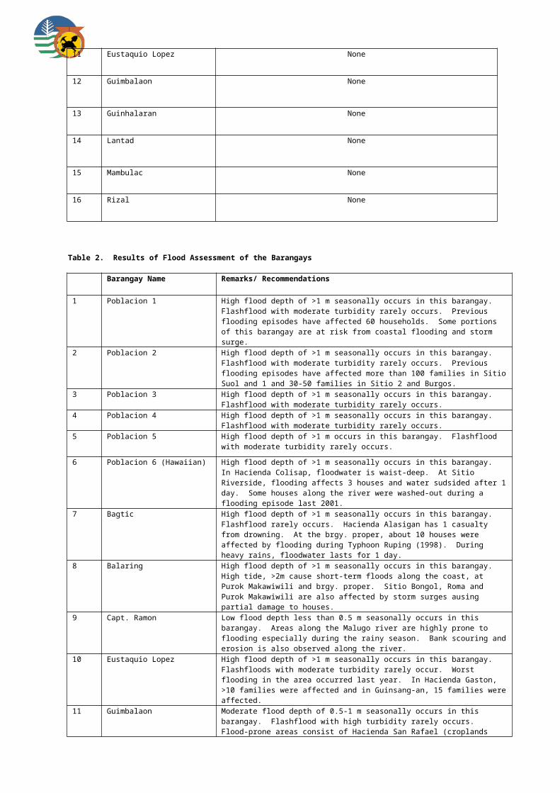
6 Zone 2 None
7 Zone 3 None
8 Zone 4 None
9 Zone 4A None
10 Zone 5 None
11 Zone 6 None
12 Zone 7 None
13 Zone 8 None
14 Zone 9 None
15 Zone 10 None
16 Zone 11 None
17 Zone 12 None
18 Zone 12A None
19 Zone 14 None
20 Zone 14A None
21 Zone 14B None
22 Zone 15 None
23 Zone 16 None
24 Bubog None
25 Efigenia Lizares None
26 Concepcion None
27 Matab-ang None
Table 2. Results of Flood Assessment of the Barangays
Barangay Name Remarks/ Recommendations

1 Cabatangan Rare occurrence of flashflood with moderate turbidity at Imbag River.
2 San Fernando Imbang and Matab-ang Rivers are commonly affected by moderate flashflood with moderate turbidity
3 Dos Hermanas Rare flashflood occurrence at Imbang River
4 Katilingban Rare flashflood with low turbidity at Malasaga and Imbang Rivers.
5 Zone 1 Low flooding occurs seasonally. Due to its proximity to Calabhan River, when heavy and prolonged rains occur sometimes but rarely at least 10% of the barangay is flooded by river by overflow and storm surge, inasmuch as the drainage system cannot contain the big volume of water.
6 Zone 2 No alarming flooding incident. The 3-6 inches depth of flooding is usually caused by clogged drainage and storm surges during heavy rains and typhoons.
7 Zone 3 Low to moderate flooding is seasonally experienced in this area due to storm surges when high tide reaches 1.8-2.1 level. Flooding varies from 3 inches to I meter depth. Purok Greenhills is a reclaimed area, while Purok Bayad where the Barangay Hall is located is also 50% reclaimed.
8 Zone 4 Low to moderate flooding. No alarming flooding incident, only once years ago during the occurrence of a typhoon that 50 families were affected at one of the Purok but not the barangay proper. Flooding during storm surges usually caused by clogged canals preventing the freeflow of water.
9 Zone 4A Low to moderate flooding. None at the bgy. Proper; Purok Malipayon experienced knee-deep flooding before but only during very heavy and prolonged rain.
10 Zone 5 None
11 Zone 6 None
12 Zone 7 None at brgy. proper; mod flood depth of 0.5-1 m was experienced in Puroks Tinago and Santan due to overflow of an unnamed creek draining towards Kabanbanan River. High turbidityflashflood is very common.
13 Zone 8 Flash flood traversing Minaluan River is very common with high turbidity. Purok Riverside affected by mod. Flood 0.5-1m during heavy rains.
14 Zone 9 Low flood depth of 0-0.5 m is experienced in the area. worst flood experience is during typhoon Ruping.
15 Zone 10 High flood level >1m along the river banks of Minaluan River, subside after 5 hrs. Worst flood during typhoon Pepang.
16 Zone 11 Mod flood depth of 0.5-1 m affected Puroks Everlasting, Santan, Pagtidaet and Sampaguita during typhoon Frank. High turbidity flashflood is very common in the area.
17 Zone 12 Low flood depth of 0-0.5 m was experienced in the area particularly when the incoming high sea water level coincides with the floodwaters affecting mostly Purok Amor, Orosa and Amor, but water subsides immediately. Bgy. Constructed a Gauge to determine the level of water in the area that serves as warning device to residents
18 Zone 12A No alarming flooding incident.
19 Zone 14 Mod flood depth of 0.5-1 m affected the whole barangay during typhoon Frank. Area is near Minuluan River where high turbidity flashflood is very common.
20 Zone 14A Puroks 3-6 located alpong the junction of Kabanbanan and Minuluan Rivers are commonly affected by very high turbidity flashflood especially during heavy rains coinciding with high tide levels affecting approx. 100 households.
21 Zone 14B High turbidity flashflood is very common in Puroks Rose, Santan, Sampaguita, Gumamela 2 and Yellow Bell especially during high tide levels along with continuous heavy rains. Area is located along Minuluan River affecting approx. 167 households.
22 Zone 15 Low flood level of 0-0.5m at Purok Minamar during continuous heavy rains that subsides readily rarely occur.
23 Zone 16 Flooding seasonally occurs, caused by storm surges especially during the months of November and December. Purok Malipayon is near Catablan River and experienced at least 1 meter –up high flooding and is rated high, while Purok Katilingban experienced moderate knee-deep flooding.
24 Bubog No alarming flood occurrence in bgy. Bubog. At the height of typhoon Ruping only portions of the highway was minimally flooded.
25 Efigenia Lizares Rare flashflood at So. Kapikilayco, Bagacay River. So. Kapisian and portions of So . Binaliwan is affected by high >1m flooding. Had. Ofelia, Virgen Duplex and Virgen

Uno is affected by mod 0.5 – 1m flood26 Concepcion Rare flashflood with mod turbidity along Imbang and Balugo Rivers.
27 Matab-ang Low 0-0.5 flood depth affects portion of the brgy. proper. Portions of Had. Llopez and Ledesma experience >1m flood during heavy rains.
Municipality of Valladolid
Table 2. Results of Flood Assessment of the Barangays
Barangay Name Remarks/ Recommendations
1 Alijis Moderate flood depth of 0.5-1 m is seasonally experienced at Sitio Pangpang wherein approximately 100 houses along Banawang River can be affected. Section of access road leading to the barangay is also affected by flood.
2 Ayungon High flood depth of >1m is experienced at the barangay during rainy season. Flash flood commonly occurs in the area. It takes 3 days before floodwaters subside.
3 Bagumbayan Low flood depth of 0-0.5 m seasonally occurs at the barangay. Coastal flooding affects approximately 100 households at Purok Cabilogan during typhoons. Seawall constructed near the barangay hall was destroyed by storm surge. It takes 3 days before floodwaters subside.
4 Batuan Moderate flood depth of 0.5-1 m is seasonally experienced at Purok Langka.
5 Bayabas High flood depth of >1m is seasonally experienced at Purok Pajo caused by overflowing of a creek adjacent to the area. It takes 7 days before floodwater recedes.
6 Central Tabao Low flood depth of 0-0.5 m is seasonally experienced at Purok Pagi, Ilak, Bansa and Gingaw affecting about 200 households. Flooding during rainy season is caused by lack of drainage exit to the sea. It takes 2 to 3 days before flood waters subside. Puroks Bulaw, Gingaw, Badlon and Lison are prone to storm surge.
7 Doldol High flood depth of >1m is seasonally experienced at Puroks Gumamela, Santan, Rose and Begonia. Flooding is caused by the overflowing of Ayungon River.
8 Guintorilan Typhoon Ondoy and Pepeng in year 2009 adversely affected Puroks Gumamela, Melion and Calinap with high flood depth of >1m.
9 Lacaron High flood depth of >1m is seasonally experienced at Puroks Rosas and Sunflower while moderate flood depth of 0.5-1 m affects the Brgy. Proper during rainy season.
10 Mabini Low flood depth of 0-0.5 m is seasonally experienced at Purok Taytay and Matugnao affecting about 20 households.
11 Pacol High flood depth of >1m is experienced at Purok Muyco, Lubi and Star apple (part of Brgy. Proper) during rainy season. Flooding lasts for 4 days affecting about 100 households.
12 Palaka Low flood depth of 0-0.5 m affects Purok 2 (Brgy. Proper), Purok 3 and 4 during continuous heavy rains.
13 Paloma Moderate flood depth of 0.5-1 m affects mainly farmlands of Purok Kalubihan, Kanipaan and Brgy. Proper.
14 Poblacion High flood depth of >1 m affects more than 100 households at Purok Sampaguita, Camia, Bougainvillea and Jasmin. Latest flooding event was during Typhoon Ondoy. Houses near the shore are affected by flood during high tide and heavy rains.
15 Sagua Banua Moderate flood depth of 0.5-1m is experienced at Purok Mainuswagon (Cawayanan) affecting about 20 houses. Excess surface runoff and lack of drainage exit cause flooding in the area.
16 Tabao Proper Moderate flood depth of 0.5-1 m is seasonally experienced at Purok Mainuswagon affecting approximately 35 houses. Flooding is caused by insufficient drainage system and presence of fishponds on the shoreline. It takes 1 week before floodwaters subside during heavy rains. Storm surge affects Purok Mabinuligon and Masinulondon affecting approximately 60 houses.

Victorias City
Table1. Results of Landslide Assessment of the barangays
Barangay Name Landslide Susceptibility Rating
1 Barangay 11 Low at brgy. proper; high in Sitios Benintigan and Siete
2 Barangay 12 Low
3 Barangay 18-A Low
4 Barangay 20 Low
5 Barangay 8 Low
6 Barangay 10 Low
7 Barangay 14 None
8 Barangay 13 None
9 Barangay 9 None
10 Barangay I None
11 Barangay 2 None
12 Barangay 3 None
13 Barangay 7 None
14 Barangay 6-A None
15 Barangay 6 None
16 Barangay 5 None
17 Barangay 21 None
18 Barangay 4 None
19 Barangay 16 None
20 Barangay 16-A None
21 Barangay 17 None

22 Barangay 19-A None
23 Barangay 18 None
24 Barangay 15 None
25 Barangay 19 None
26 Barangay 15-A None
Table 2. Results of Flood Assessment of the Barangays
Barangay Name Remarks/ Recommendations
1 Barangay 9 In 1995, high flood depth of >1m is experienced in this area due to continuous heavy downpour for several days. The sudden increase in water level is indicative of flash flood. Rise in sea level aggravated the situation.
2 Barangay 1 In 1995, high flood depth of >1m is experienced in this area due to continuous heavy downpour for several days. The sudden increase in water level is indicative of flash flood. Rise in sea level aggravates the situation.
3 Barangay 2 In 1995, high flood depth of >1m is experienced in this area due to continuous heavy downpour for several days. The sudden increase in water level is indicative of flash flood. Rise in sea level aggravates the situation.
4 Barangay 3 In 1995, high flood depth of >1m is experienced in this area due to continuous heavy downpour for several days. The sudden increase in water level is indicative of flash flood. Rise in sea level aggravates the situation. Adversely affected is the low-lying Yap Quiño Subdivision.
5 Barangay 6 In 1995, high flood depth of >1m is experienced in this area due to continuous heavy downpour for several days. The sudden increase in water level is indicative of flash flood. Rise in sea level aggravates the situation. Affected areas are Estrella, Lopez and Salvacion Subdivisions.
6 Barangay 4 High flood depth of >1m is experienced in this area. Heavily affected is Zone 6 that is the lowest portion of the barangay.
7 Barangay 18-A In 1995, high flood depth of >1m is experienced in this area due to continuous heavy downpour for several days. The sudden increase in water level, indicative of flash flood affects Purok Golf with approximately 70 households. Likewise, Puroks Cubay 1 and 2 are seasonally flooded.
8 Barangay 16 High flood depth of >1m is seasonally experienced in this area adversely affecting the 60 households situated at the riverbanks. The presence of numerous fishponds also hinders the free flowage of floodwater to the open sea, thus aggravating the situation.
9 Barangay 16-A In 1995, high flood depth of >1m is experienced in this area due to continuous heavy downpour for several days. The sudden increase in water level is indicative of flash flood. Rise in sea level aggravates the situation.
10 Barangay 17 In 1995, high flood depth of >1m is experienced in this area due to continuous heavy downpour for several days. The sudden increase in water level is indicative of flash flood. Rise in sea level aggravates the situation.
11 Barangay 13 In 1995, high flood depth of >1m is experienced in this area due to continuous heavy downpour for several days and rise in sea level aggravated the flooding situation. This is the worst water level ever experienced in the barangay. However, in 2008, Sitio So-ol is submerged by deep floodwaters when the adjacent creek could no longer contain the floodwater draining the water canal. To mitigate, the widening of the creek eased the flowage of water and hence, lessens the flooding incidents.
12 Barangay 18 In 1995, high flood depth of >1m is experienced in this area due to continuous heavy downpour for several days. The sudden increase in water level is indicative of flash flood. Rise in sea level aggravates the situation.
13 Barangay 19 High flood depth of >1m is seasonally experienced in this area. Overflow of rainwater from Malihao River causes flooding in the area.

14 Barangay 19-A In 1995, high flood depth of >1m is experienced in this area due to continuous heavy downpour for several days. Rise in sea level aggravated the situation. Malihao, Pusod and Lasalle creeks that bound the area cause the flooding in the barangay.
15 Barangay 6-A The barangay proper experiences moderate flood depth of 0.5-1 m. However, there are areas in the barangay that experiences high flood depth of >1m in Zone 1-Villa Miranda. The presence of numerous informal dwellers at the mouth of the river channels aggravates the ease of water flowage out to the open sea.
16 Barangay 10 Moderate flood depth of 0.5-1 m is experienced in this area. Quinaruyan River is the source of flashflood in the area.
17 Barangay 15 Moderate flood depth of 0.5-1 m is experienced in this area.
18 Barangay 11 Moderate flood depth of 0.5-1 m is experienced in this area.
19 Barangay 15-A Low flood depth of 0-0.5 m is seasonally experienced in this area.
20 Barangay 12 None at barangay proper; however, isolated areas in Purok 4 affect three (3) households every time water overflows from Dacumon creek.
21 Barangay 7 None at barangay proper; however, In 1995, high flood depth of >1m is experienced in some low-lying areas such as Bandong Village (Phases 1 and 2) due to continuous heavy downpour for several days. These areas are situated near the riverbanks.
22 Barangay 5 None at barangay proper; but low flood depth of 0-0.5 m at Zone 5- Damas Extension due to poor drainage system and indiscriminate garbage disposal.
23 Barangay 21 None at barangay proper; however, the two (2) low-lying relocation sites situated along the river banks – Palanca Village and Relocation Porject Brgy. XXI, experience high flood depth of >1m.
24 Barangay 20 None at barangay proper; but high flood depth of >1m is experienced in Purok Pusan and Hacienda Sta. Cruz. Overflow of Hacienda Sta. Cruz and Quinton Rivers cause flooding in the area where 300 households are severely affected.
25 Barangay 14 None
26 Barangay 8 None