Embed Size (px)
Citation preview
CXC 02/0/SYLL 15
CARIBBEAN EXAMINATIONS COUNCIL
Car ibbean Secondary Educat ion Cer t if icat e
CSEC®
GEOGRAPHY SYLLABUS
Effective for examinations from May-June 2017
CXC 02/0/SYLL 15
Published by the Caribbean Examinations Council © 2015, Caribbean Examinations Council All rights reserved. No part of this publication may be reproduced, stored in a retrieval system, or transmitted in any form, or by any means electronic, photocopying, recording or otherwise without prior permission of the author or publisher. Correspondence related to the syllabus should be addressed to: The Pro-Registrar Caribbean Examinations Council Caenwood Centre 37 Arnold Road, Kingston 5, Jamaica, W.I. Telephone: (876) 630-5200 Facsimile Number: (876) 967-4972 E-mail address: [email protected] Website: www.cxc.org Copyright © 2015, by Caribbean Examinations Council Prince Road, Pine Plantation Road, St Michael BB11091

CXC 02/0/SYLL 15
The Geography Syllabus (CXC 02/0/SYLL 05) was revised in 2015 for first examinations in 2017.
Teaching is expected to commence on the revised syllabus in September 2015.
The amendments to the syllabus are indicated by italics.
Please check the website www.cxc.org for updates on CXC’s syllabuses.
CXC 02/0/SYLL 15
RATIONALE ....................................................................................................................................1 AIMS .............................................................................................................................................2 GENERAL OBJECTIVES ....................................................................................................................2 ORGANISATION OF THE SYLLABUS ..................................................................................................3 APPROACHES TO TEACHING THE SYLLABUS ....................................................................................3 SUGGESTED TIMETABLE ALLOCATION.............................................................................................4 CERTIFICATION ..............................................................................................................................4 DEFINITION OF PROFILE DIMENSIONS ............................................................................................4 FORMAT OF THE EXAMINATIONS ..................................................................................................5 REGULATIONS FOR RESIT CANDIDATES ...........................................................................................8 REGULATIONS FOR PRIVATE CANDIDATES ......................................................................................8 STUDY AREAS OF THE SYLLABUS .....................................................................................................9 SECTION I – PRACTICAL SKILLS AND FIELD STUDY ............................................................................10 SECTION II – NATURAL SYSTEMS ....................................................................................................16 SECTION III – HUMAN SYSTEMS ....................................................................................................22 SCHOOL-BASED ASSESSMENT .........................................................................................................27 RESOURCES ...................................................................................................................................44 APPENDIX 1 – EXAMPLE OF A COMPLETED STRATEGY SHEET...........................................................47 GLOSSARY ......................................................................................................................................48
Contents
CXC 02/0/SYLL 15 1
RATIONALE Geography is concerned with the spatial distribution of human and natural systems and the inter-relationships between them. It facilitates an understanding of both the issues emerging from human exploitation of natural resources and how natural resources may be managed to assure sustainability. It contributes to an awareness and understanding of the natural environment and fosters an appreciation of its sustainability. It also encourages the development of a sense of responsibility in using and conserving the natural resources of the planet. Spatial appreciation, interpretation of a variety of illustrations and map reading skills are essential to a study of the subject. These skills enable an individual to operate better in space by being able to establish a location and an orientation of an area and to be able to read the landscape as well as assess the forces which have shaped them. The study of Geography, therefore, prepares an individual not only for a career in fields such as teaching, environment planning and management, international relations and geographical information systems, but also helps to develop skills that are beneficial in other fields. In addition, it contributes to more meaningful and enjoyable travel and related leisure activities. The CSEC Geography syllabus, though not limited to a study of the Caribbean, focuses on areas that are particularly relevant to Caribbean students. The syllabus utilises field studies to concretise the link between the subject matter of Geography and the methods of investigation associated with it. By being engaged in the conduct of a field study, the student gets an opportunity to observe, experience, reflect on, and draw conclusions about the intricate inter-dependence and inter-relationships that comprise the human and natural systems. A student completing the CSEC Geography syllabus should be able to make informed and rational decisions and act responsibly with respect to the human and natural systems. Based on the attributes of the Ideal Caribbean Person as articulated by CARICOM, this course will also contribute to the development of a person who demonstrates multiple literacies, independent and critical thinking, questions past and present practices and brings this analysis to bear on an innovative application of science and technology to solving problems one might encounter from day to day. This course of study will also contribute to a person who will learn to know, learn to do, learn to live with others, learn to be and learn to transform oneself and society.
Geography Syllabus
CXC 02/0/SYLL 15 2
AIMS The syllabus aims to: 1. develop an understanding of geographical phenomena; 2. stimulate interest in the nature of natural and human systems and their interaction; 3. promote an understanding of the processes at work in natural and human systems; 4. develop an understanding of the inter-relationships between the natural and the human
environment; 5. foster an awareness of the need for the sustainable use of the earth’s resources; 6. develop practical skills to enhance geographical knowledge; and 7. promote knowledge and understanding of Geography at the local, regional and global scales.
GENERAL OBJECTIVES On completion of this syllabus, students should: 1. acquire practical skills and techniques in drawing sketch maps and diagrams and in reading
and interpreting maps, photographs, tables and graphs which give geographical information; 2. understand geomorphic, atmospheric and biotic systems; 3. understand the relationship between the natural and human systems; 4. appreciate their role as individuals in the sustainable use of the environment; 5. recognise the national and regional responsibilities for the sustainable use of the environment; 6. understand the spatial and cultural factors affecting the distribution and structure of human
population; 7. account for the growth of urban settlements; 8. develop an awareness and understanding of factors influencing the spatial patterns of
economic activity; 9. understand the impact of the human systems on the environment; 10. recognise their social and civic responsibility towards the use of resources and the
environment.
CXC 02/0/SYLL 15 3
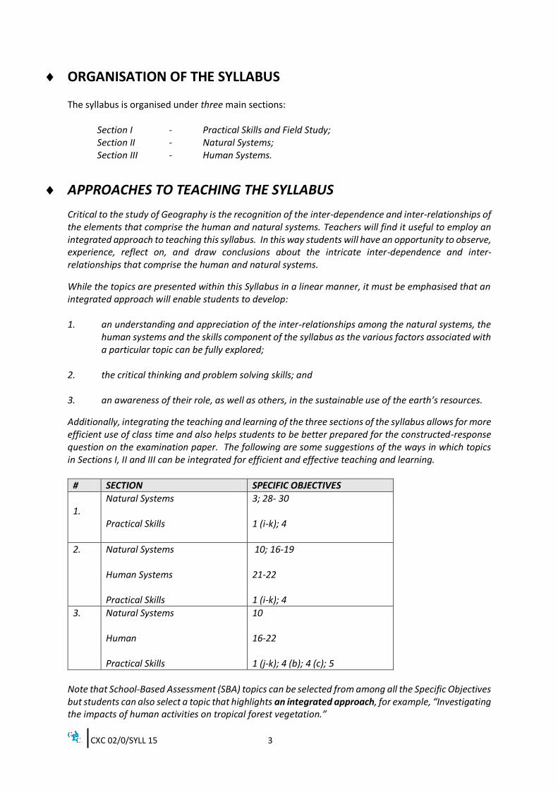
ORGANISATION OF THE SYLLABUS The syllabus is organised under three main sections:
Section I - Practical Skills and Field Study; Section II - Natural Systems; Section III - Human Systems.
APPROACHES TO TEACHING THE SYLLABUS
Critical to the study of Geography is the recognition of the inter-dependence and inter-relationships of the elements that comprise the human and natural systems. Teachers will find it useful to employ an integrated approach to teaching this syllabus. In this way students will have an opportunity to observe, experience, reflect on, and draw conclusions about the intricate inter-dependence and inter-relationships that comprise the human and natural systems.
While the topics are presented within this Syllabus in a linear manner, it must be emphasised that an integrated approach will enable students to develop: 1. an understanding and appreciation of the inter-relationships among the natural systems, the
human systems and the skills component of the syllabus as the various factors associated with a particular topic can be fully explored;
2. the critical thinking and problem solving skills; and 3. an awareness of their role, as well as others, in the sustainable use of the earth’s resources.
Additionally, integrating the teaching and learning of the three sections of the syllabus allows for more efficient use of class time and also helps students to be better prepared for the constructed-response question on the examination paper. The following are some suggestions of the ways in which topics in Sections I, II and III can be integrated for efficient and effective teaching and learning.
# SECTION SPECIFIC OBJECTIVES
1.
Natural Systems Practical Skills
3; 28- 30 1 (i-k); 4
2. Natural Systems Human Systems Practical Skills
10; 16-19 21-22 1 (i-k); 4
3. Natural Systems Human Practical Skills
10 16-22 1 (j-k); 4 (b); 4 (c); 5
Note that School-Based Assessment (SBA) topics can be selected from among all the Specific Objectives but students can also select a topic that highlights an integrated approach, for example, “Investigating the impacts of human activities on tropical forest vegetation.”
CXC 02/0/SYLL 15 4
SUGGESTED TIMETABLE ALLOCATION It is recommended that a minimum of five 40-minute periods per week, over two academic years or the equivalent be allocated to the syllabus. The time should include at least one double period.
CERTIFICATION The syllabus is offered for General Proficiency certification. A candidate’s performance will be indicated on the certificate by an overall numerical grade on a six-point scale as well as a letter grade for each of three profile dimensions, namely, Practical Skills, Knowledge and Comprehension, and Use of Knowledge.
DEFINITION OF PROFILE DIMENSIONS On completion of the syllabus, students are expected to develop skills under three profile dimensions: 1. Practical Skills (PS);
2. Knowledge and Comprehension (KC);
3. Use of Knowledge (UK). Practical Skills (PS) The ability to: 1. use scale for measurements;
2. read maps;
3. collect and collate data for geographical analysis;
4. draw maps, diagrams and sketches;
5. construct graphs, tables and divided circles using simple statistical data;
6. read and identify patterns in maps, photographs, diagrams, graphs and tables.
CXC 02/0/SYLL 15 5
Knowledge and Comprehension (KC) The ability to: 1. define terms and recall facts on a range of geographical phenomena; 2. describe processes impacting on the development of the natural and human environments; 3. describe the interaction between biotic and abiotic factors in an area or biome. Use of Knowledge (UK) The ability to: 1. explain geographical processes;
2. interpret and draw inferences from geographical data;
3. disaggregate and organise information to show inter-relationships;
4. explain the importance of the factors contributing to the development of natural and human environments;
5. draw conclusions.
FORMAT OF THE EXAMINATION The examination is offered at the General Proficiency level. The assessment comprises three papers: Paper 01, Paper 02 and Paper 031 OR Paper 032. Papers 01 and 02 are assessed externally. Paper 031 is the SBA and is assessed internally by the teacher and moderated by CXC. Paper 032 is an alternative to the SBA, assessed externally and is intended for those students who registered to sit the examination as private candidates. EXTERNAL ASSESSMENT BY WRITTEN PAPERS (80 per cent of total assessment) Paper 01 (1 hour 30 minutes, 30 per cent of total assessment) 1. Composition of the Paper
Paper 01 consists of 60 multiple choice items assessing all areas of the syllabus. All questions are compulsory.
2. Mark Allocation
This paper is marked out of a total of 60. The marks are distributed across questions and profiles as indicated below:
CXC 02/0/SYLL 15 6
Practical Skills (PS) - 24 Knowledge and Comprehension (KC) - 28 Use of Knowledge (UK) - 08
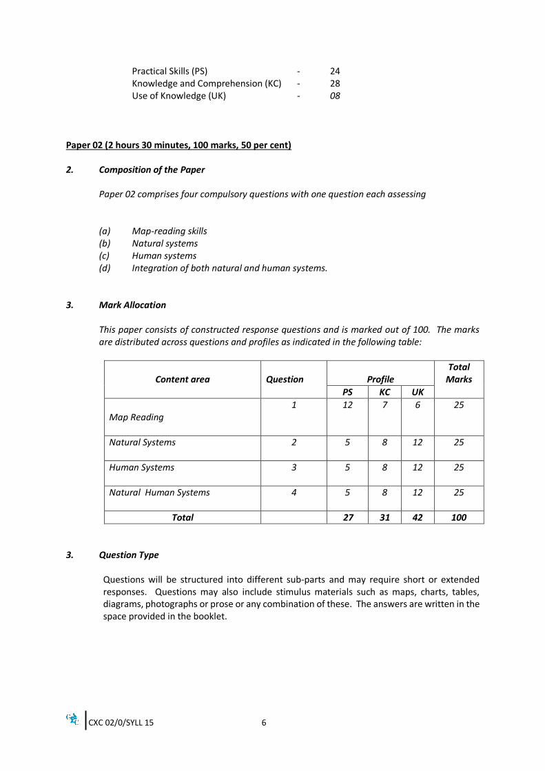
Paper 02 (2 hours 30 minutes, 100 marks, 50 per cent) 2. Composition of the Paper
Paper 02 comprises four compulsory questions with one question each assessing (a) Map-reading skills (b) Natural systems (c) Human systems (d) Integration of both natural and human systems.
3. Mark Allocation
This paper consists of constructed response questions and is marked out of 100. The marks are distributed across questions and profiles as indicated in the following table:
Content area
Question
Profile
Total Marks
PS KC UK
Map Reading
1 12 7 6 25
Natural Systems 2 5 8 12 25
Human Systems 3 5 8 12 25
Natural Human Systems 4 5 8 12 25
Total 27 31 42 100
3. Question Type
Questions will be structured into different sub-parts and may require short or extended responses. Questions may also include stimulus materials such as maps, charts, tables, diagrams, photographs or prose or any combination of these. The answers are written in the space provided in the booklet.
CXC 02/0/SYLL 15 7
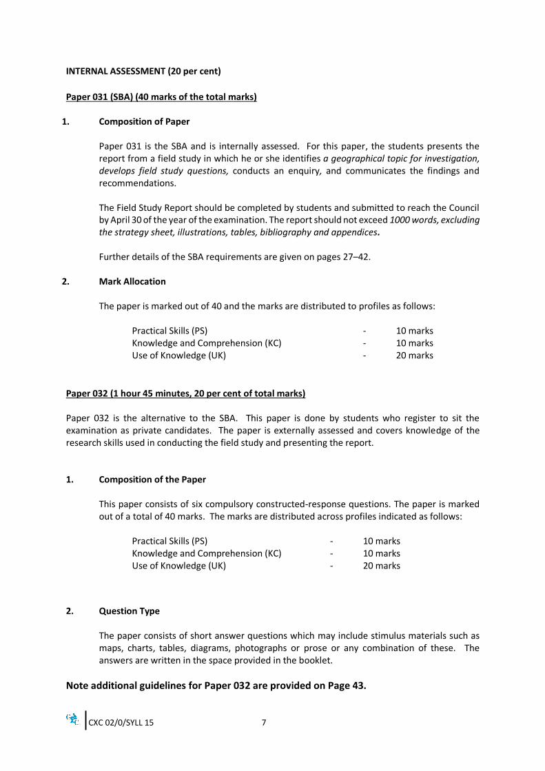
INTERNAL ASSESSMENT (20 per cent)
Paper 031 (SBA) (40 marks of the total marks)
1. Composition of Paper
Paper 031 is the SBA and is internally assessed. For this paper, the students presents the report from a field study in which he or she identifies a geographical topic for investigation, develops field study questions, conducts an enquiry, and communicates the findings and recommendations.
The Field Study Report should be completed by students and submitted to reach the Council by April 30 of the year of the examination. The report should not exceed 1000 words, excluding the strategy sheet, illustrations, tables, bibliography and appendices. Further details of the SBA requirements are given on pages 27–42.
2. Mark Allocation
The paper is marked out of 40 and the marks are distributed to profiles as follows:
Practical Skills (PS) - 10 marks Knowledge and Comprehension (KC) - 10 marks Use of Knowledge (UK) - 20 marks
Paper 032 (1 hour 45 minutes, 20 per cent of total marks) Paper 032 is the alternative to the SBA. This paper is done by students who register to sit the examination as private candidates. The paper is externally assessed and covers knowledge of the research skills used in conducting the field study and presenting the report. 1. Composition of the Paper
This paper consists of six compulsory constructed-response questions. The paper is marked out of a total of 40 marks. The marks are distributed across profiles indicated as follows:
Practical Skills (PS) - 10 marks Knowledge and Comprehension (KC) - 10 marks Use of Knowledge (UK) - 20 marks
2. Question Type
The paper consists of short answer questions which may include stimulus materials such as maps, charts, tables, diagrams, photographs or prose or any combination of these. The answers are written in the space provided in the booklet.
Note additional guidelines for Paper 032 are provided on Page 43.
CXC 02/0/SYLL 15 8
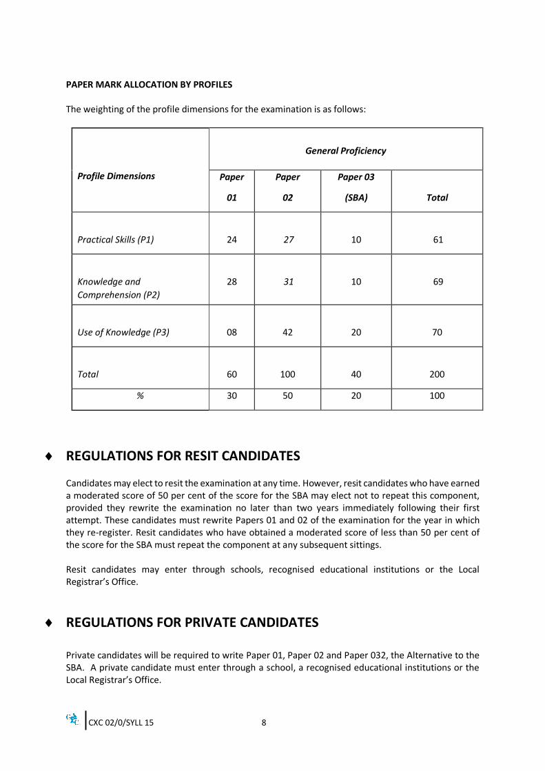
PAPER MARK ALLOCATION BY PROFILES The weighting of the profile dimensions for the examination is as follows:
Profile Dimensions
General Proficiency
Paper
01
Paper
02
Paper 03
(SBA)
Total
Practical Skills (P1)
24
27
10
61
Knowledge and
Comprehension (P2)
28
31
10
69
Use of Knowledge (P3)
08
42
20
70
Total
60
100
40
200
% 30 50 20 100
REGULATIONS FOR RESIT CANDIDATES Candidates may elect to resit the examination at any time. However, resit candidates who have earned a moderated score of 50 per cent of the score for the SBA may elect not to repeat this component, provided they rewrite the examination no later than two years immediately following their first attempt. These candidates must rewrite Papers 01 and 02 of the examination for the year in which they re-register. Resit candidates who have obtained a moderated score of less than 50 per cent of the score for the SBA must repeat the component at any subsequent sittings. Resit candidates may enter through schools, recognised educational institutions or the Local Registrar’s Office.
REGULATIONS FOR PRIVATE CANDIDATES Private candidates will be required to write Paper 01, Paper 02 and Paper 032, the Alternative to the SBA. A private candidate must enter through a school, a recognised educational institutions or the Local Registrar’s Office.
CXC 02/0/SYLL 15 9
STUDY AREAS OF THE SYLLABUS Study areas from the Caribbean and selected countries outside of the Caribbean should be drawn from the areas listed below. Caribbean Anguilla, Antigua and Barbuda, The Bahamas, Barbados, Belize, Cayman Islands, Cuba, Dominica, Dominican Republic, Dutch Caribbean, Grenada, Guadeloupe, Guyana, Haiti, Jamaica, Martinique, Montserrat, Puerto Rico, St Kitts and Nevis, St Lucia, St Vincent and the Grenadines, Suriname, Trinidad and Tobago, Turks and Caicos Islands, the Virgin Islands. Countries outside of the Caribbean United States of America, United Kingdom, Singapore, Brazil, India, China and Nigeria.
CXC 02/0/SYLL 15 10
SECTION I: PRACTICAL SKILLS AND FIELD STUDY
GENERAL OBJECTIVE On completion of this section, students should acquire practical skills and techniques in drawing sketch maps and diagrams and in reading and interpreting maps, photographs, tables and graphs which give geographical information.
SPECIFIC OBJECTIVES 1. Given an extract from a topographic map of any Caribbean territory, or a sketch map, students
should be able to:
(a) (i) read conventional (map) symbols;
(ii) interpret conventional (map) symbols. (b) locate places, using four and six-figure grid references; (c) give direction of one place in relation to another using the 16 points of the compass; (d) measure the grid bearing of one place in relation to another; (e) use the scale to measure straight and curved distances: (f) (i) copy a section of the map;
(ii) reduce a section of the map;
(iii) enlarge a section of a map.
(g) (i) draw cross sections and sketch sections;
(ii) interpret cross sections and sketch sections;
(h) (i) calculate gradients;
(ii) differentiate among steep, moderate and gentle slopes;
(i) draw diagrams to illustrate geographical features; (j) describe landscapes using the following: relief, drainage and land use; (k) explain the inter-relationships among relief, drainage and land use.
CXC 02/0/SYLL 15 11
SECTION I: PRACTICAL SKILLS AND FIELD STUDY (cont’d)
2. Given a ground or aerial photograph, sketch map or a diagram, students should be able to: interpret geographical features.
3. Students should be able to:
(a) illustrate weather systems, using isobars and relevant symbols;
(b) interpret rainfall and temperature graphs and maps.
4. Students should be able to:
(a) (i) identify the main lines of latitude and longitude;
(ii) locate a place from its latitude and longitude;
(iii) calculate the Standard Time of places.
(b) name and locate countries in the Caribbean; (c) draw sketch maps to show relative location and spatial distribution;
(d) draw diagrams to illustrate geographical features;
5. Students should be able to:
(a) construct tables, graphs and draw diagrams as specified in the content;
(b) use descriptive statistics (mean, median and mode) to summarise data;
(c) interpret graphs, tables, statistical maps and diagrams as specified in the content.
6. Students should be able to:
collect, record and present information based on a geographical field study on at least one (1)
chosen objective from the syllabus.
CXC 02/0/SYLL 15 12
SECTION I: PRACTICAL SKILLS AND FIELD STUDY (cont’d) CONTENT 1. MAPS:
(a) Essential elements of maps (title, scale, legend, north point and border); placement
of labels and the use of colours); (b) Grid references – 4 and 6 figures;
(c) Compass Direction (16 points); (d) Grid bearings measured clockwise from Grid North (indicated by the direction of the
Easting lines); (e) Measuring straight and curved distances (to nearest 100 metres); (f) Copying, reducing or enlarging topographic maps guided by the map scale;
(g) Cross sections and sketch sections including inter-visibility (profile view of the
landscape and relief and whether or not one point could be seen from another); (h) (i) Calculate gradient, using ratios and percentages;
(ii) variations in slope – steep, moderate and gentle;
(i) Diagrams that illustrate features of the physical (for example, land above a certain height, distribution of major landforms) and human environment (for example, distribution of farmland, settlement or forest);
(j) Landscape descriptions:
(i) Relief – the distribution, height and size of landforms; types of slopes (concave, convex, straight, terraced/stepped); nature and height of slopes (steep, gentle, undulating, uneven), spurs, valleys, plains, depressions, ridges, plateaux, escarpments, cliffs, passes (cols, saddles); (ii) Drainage – drainage patterns, density, direction of flow, quality of the drainage, shape and size of channel; (iii) Land use – vegetation, agriculture, industry, transport networks and settlement form and distribution.
(k) Landscape inter-relationship and patterns (map correlations); the association among relief, land use patterns and drainage.
CXC 02/0/SYLL 15 13
SECTION I: PRACTICAL SKILLS AND FIELD STUDY (cont’d) 2. Photographs, Maps and Diagrams
Landforms/features (physical and human) in photographs, maps and diagrams relevant to the Syllabus.
3. Weather systems
(a) Weather systems – their pattern of isobars; relevant symbols and wind direction: Inter- Tropical Convergent Zone (ITCZ), tropical waves, tropical storms/hurricanes, cold fronts anticyclones. (Note that station models not required).
(b) Rainfall and temperature graphs and maps (for example, range, seasons, relationship
between temperature and rainfall).
4. Location and Time
(a) (i) Main lines of latitude and longitude (Equator, Tropics of Cancer and Capricorn, Arctic and Antarctic Circles, North and South Poles, Greenwich/ Prime Meridian); (ii) Name and locate a place from its latitude and longitude;
(iii) Earth’s rotation, longitude and time.
(b) Caribbean Countries as outlined in the syllabus.
(c) Sketch maps that illustrate relative location and spatial distribution.
(d) Diagrams that illustrate geographical features (apart from those on topographical maps).
5. Tables, Graphs, Maps and Central Tendency
(a) Construction of tables, bar graphs, line graphs, divided circles, climate graphs, dot maps.
(b) Measures of Central Tendency: mean, median and mode. (c) Interpretation of data on charts, tables, bar graphs (including population pyramids),
line graphs, climate graphs, divided circles, dot maps, choropleth maps and isopleth maps.
CXC 02/0/SYLL 15 14
SECTION I: PRACTICAL SKILLS AND FIELD STUDY (cont’d) 6. FIELD STUDY
(a) (i) Field study topic based on at least one of the specific objectives of the syllabus;
(ii) Field study questions;
(iii) Instruments to collect data.
(b) Use of research techniques:
(i) sampling methods (for example, random, stratified and point); (ii) data collecting methods (for example, questionnaires; interviews; checklists,
field observations).
(c) Maps: (i) site showing the immediate area – large-scale (1:10 000; 1:25 000); (ii) location – small-scale maps (Atlas scale or larger) to show regional or
national position. (d) Ensure the use of appropriate map symbols (for example, use of conventional symbols
and colours) and relevant annotated photographs and diagrams. Suggested Teaching and Learning Activities To facilitate students’ attainment of the objectives of this Section, teachers are advised to engage students in the teaching and learning activities listed below. 1. Use topographic maps to identify conventional map symbols and observe the patterns and the
interrelationship of relief, drainage and land use. (The school surroundings can be used to highlight inter-relationships).
2. Measuring distance: Help students to appreciate that different units of measurement are more
appropriate for (a) large distances (for example, the journey from school to the furthest settlement in your country – kms/miles); (b) intermediate distances (for example, the height of the classroom window – metres/feet); and (c) small distances (for example, the size of a pencil-cm/inches).
3. Guide students to build models of parts of topographical maps, attaching labels to identify
different relief forms. 4. Grid References: Design exercises that require students to use their rulers to subdivide a
square. 5. Design lessons using the temperature and rainfall maps and diagrams in the atlas and from
the Internet. Have students interpret and draw inferences from this data.
CXC 02/0/SYLL 15 15
SECTION I: PRACTICAL SKILLS AND FIELD STUDY (cont’d) 6. Google Earth software could be used to show how an area has changed overtime using the
relevant function on this software. Traditional relief maps could also be draped over or added as a layer in Google Earth, so that students could see the relationship between satellite images and topographical maps. Students would also see more recent representations of an area. Exercises on location, land uses and other spatial patterns as well as the inter-relationship between the physical and human environment can also be designed using Google maps.
7. Use virtual field trips as a strategy to build data collection, presentation and other skills
associated with the SBA. Group work and role playing can be incorporated here. Have students design and administer questionnaires linked to the specific objectives.
8. Invite personnel involved in the creation, use or maintenance of Spatial Data (Geographic
Information Systems agencies) to make presentations to the class on how spatial data is generated, used and stored. (Field trips to such agencies can also be arranged). This would enable students to compare traditional versus contemporary ways in which spatial data is used. This will also help students to better understand and appreciate the relevance of the skills component of Geography.
CXC 02/0/SYLL 15 16
SECTION II - NATURAL SYSTEMS
GENERAL OBJECTIVES On completion of this section, students should: 1. understand geomorphic, atmospheric and biotic systems;
2. understand the relationship between the natural and human systems; 3. appreciate their role as individuals in the sustainable use of the environment; 4. recognise the national and regional responsibilities for the sustainable use of the environment.
SPECIFIC OBJECTIVES Systems Associated With the Lithosphere, Atmosphere, Biosphere and Hydrosphere Students should be able to: 1. describe the internal structure of the earth; 2. explain the theory of plate tectonics; 3. describe the consequences of the movement of plates; 4. explain the formation of intrusive and extrusive volcanic features;
5. describe the formation of the three types of rock;
6. (a) define weathering;
(b) explain the processes of weathering as specified in the content;
(c) explain the processes of mass movement as specified in the content;
7. explain the formation of limestone features in the Caribbean as stated in the content;
8. differentiate between weather and climate; 9. explain the factors influencing the weather and climate of a place as stated in the content; 10. describe the characteristics of the Equatorial and Tropical Marine Climates;
11. describe the weather conditions associated with Caribbean weather systems;
12. describe the “greenhouse effect”;
CXC 02/0/SYLL 15 17
SECTION II - NATURAL SYSTEMS (cont’d) 13. describe the ways in which human activities influence climate change; 14. compare the consequences of climate change in the Caribbean with those in EITHER the United
States of America (USA) OR the United Kingdom (UK); 15. compare measures to reduce the effects of climate change in the Caribbean with those of
EITHER the United States of America (USA) OR the United Kingdom (UK); 16. (a) describe the adaptations of vegetation to the environment;
(b) explain the characteristics of the Tropical Rainforest biome;
17. explain the impact of human activities on the tropical forests’ biomes in the Caribbean;
18. describe the major constituents of soil; 19. explain the factors influencing the formation of latosols; 20. describe the hydrological cycle; 21. (a) describe river processes;
(b) describe wave processes;
22. (a) explain the formation of river landforms; (b) explain the formation of coastal landforms;
23. describe drainage patterns; 24. describe types of coral reefs; 25. describe the conditions necessary for the successful formation of coral reefs in the Caribbean; 26. explain the importance of coral reefs in the Caribbean;
27. explain the importance of mangrove wetlands in the Caribbean;
28. distinguish between a natural hazard and a natural disaster; 29. describe the impact of earthquakes, hurricanes, volcanoes, landslides and flooding on the
physical and human environments in the Caribbean; 30. explain the responses of individuals, national and regional agencies in the Caribbean to reduce
the effects of the natural hazards and disasters identified in Objective #29.
CXC 02/0/SYLL 15 18
SECTION II - NATURAL SYSTEMS (cont’d)
CONTENT Systems Associated with the Lithosphere. Atmosphere, Biosphere and Hydrosphere Structure of the Lithosphere, Plate Tectonics and Rock Formation 1. Internal structure of the earth including continental and oceanic plates, crust, mantle and core. 2. Theory of plate tectonics, including global distribution of plates, movement of plates and types
of plate boundaries. 3. The occurrence and the distribution of earthquakes, island arcs, volcanoes, fold mountains,
major faults and ocean trenches. 4. Characteristics of:
(a) Intrusive volcanic features (sills, dykes, plugs and batholiths);
(b) Extrusive volcanic features (caldera, shield volcano, composite cone, lava plateau). 5. The rock cycle: formation of igneous, sedimentary and metamorphic rocks.
Weathering and Mass Movement 6. (a) Definition of weathering, emphasising the “in situ” condition.
(b) (i) Location, processes and results of chemical weathering (carbonation and hydrolysis); (ii) Location, processes and results of physical weathering (frost action, exfoliation); (iii) Processes and results of biological weathering.
(c) Definition, causes and results of mass movement (soil creep and landslides).
7. The characteristics of limestone and the processes leading to the formation of limestone
features created on the surface (clints and grykes, surface depressions, cockpits, swallow holes) and underground (caves, stalactites, stalagmites, pillars, underground rivers).
Weather, Climate, Vegetation and Soil. 8. Difference between weather and climate. 9. Factors influencing weather and climate: latitude, altitude, relief, distance from the sea
(continentality) and winds (land and sea breezes and prevailing winds).
CXC 02/0/SYLL 15 19
SECTION II - NATURAL SYSTEMS (cont’d) 10. Characteristics of Equatorial and Tropical Marine Climates – temperature, precipitation,
pressure. 11. Weather conditions associated with Caribbean weather systems:
(a) tropical waves, hurricanes and cold fronts (before, during and after);
(b) ITCZ and anticyclones.
12. Insolation, radiation and the role of greenhouse gases in heating the earth.
13. Human activities that contribute to global warming and influence climate change (such as deforestation and activities that lead to emissions of carbon dioxide and other greenhouse gases).
14. Examples of the consequences of Climate Change in the Caribbean and EITHER United States
of America (USA) OR the United Kingdom (UK): for example, sea level rise – examples of increased incidence of coastal flooding, impacts on coral reefs, coastal wetlands and settlements; changes in weather patterns and their impacts.
15. Measures to reduce the effects of climate change in the Caribbean and that of EITHER the
United States of America (USA) OR the United Kingdom (UK) (for example, mitigation measures including reduced emissions, sustainable forestry, education).
16. (a) Adaptations of vegetation to the environmental factors of climate, soil, biotic
conditions (including humans).
(b) The inter-relationship among climate, vegetation and soil seen in the characteristics of the tropical rainforest biome: types of trees; types of leaves and roots; structure; species composition; seasonality.
17. Positive impacts (sustainable management) and negative impacts (deforestation, soil erosion,
soil exhaustion) of human activities on tropical forests’ biomes. 18. Major constituents of soil: organic and inorganic matter, bacteria, water and air.
19. Factors influencing the formation of latosols: interaction amongst climate, vegetation, biota,
and water in soil. Fluvial and Coastal Processes 20. The hydrological cycle (evaporation, condensation, precipitation, transpiration, run-off,
infiltration, through-flow, percolation, ground water flow) and its features (springs, aquifers, water table).
21. (a) Drainage system – fluvial processes (erosion, transportation, deposition).
CXC 02/0/SYLL 15 20
SECTION II - NATURAL SYSTEMS (cont’d)
(b) Coastal system – wave processes (erosion, transportation and deposition). 22. Landforms:
(a) rivers – river valleys, waterfalls, meanders, braided channels, ox-bow lakes, levees, flood plains, deltas.
(b) coastal – cliff, wave-cut platform, headland, bay, cave, arch, stack, spit, bay-bar, tombolo, beach;
23. Drainage patterns – dendritic, trellis, radial and relationship to rock type and geology;
24. Types of coral reefs: fringing, barrier and atoll.
25. Conditions necessary for the successful formation of coral reefs: water – depth, salinity,
temperature, turbidity; the presence of beneficial algae and fish.
26. Importance of coral reefs – coastal protection; raw material for beaches; ecological and economic benefits.
27. Importance of mangrove wetlands: coastal protection; ecological; socio-economic benefits. Natural Hazards and Natural Disasters 28. Difference between a natural hazard and a natural disaster.
(a) Natural hazard – risk resulting from processes associated with the lithosphere, biosphere and atmosphere.
(b) Natural disaster – effects of the event on the physical and human landscapes, especially in areas of high population density.
29. (a) Areas in Caribbean countries at high risk from the hazards of earthquakes, hurricanes, volcanoes, landslides, flooding. (b) The effects of natural hazards and disasters – short term and long term.
30. Responses of individuals, national and regional agencies to the risk of the hazards and the
effects of natural disasters in the Caribbean: the stages in the hazard/disaster management cycle.
CXC 02/0/SYLL 15 21
SECTION II - NATURAL SYSTEMS (cont’d) Suggested Teaching and Learning Activities
To facilitate students’ attainment of the objectives of this Section, teachers are advised to engage
students in the teaching and learning activities listed below. 1. Have students create a concept map or poster showing the impact of plate tectonics on the
physical and human environment. 2. Place students in groups to create a news report/documentary/skit on the hazards that affect
the region. Ask students to conduct interviews, Internet research, review maps to aid with their presentations.
3. Invite an environmentalist to make an interactive presentation on the challenges faced by
fluvial (river) and/or coastal systems as a result of both natural and human factors. The presentation can be followed by a question and answer session between the students and the expert on the methods that can be adopted to improve the monitoring of the particular environment. The students should be encouraged to explore their role in the sustainable use and management of the environment.
4. Have students tour the school as a class, paying close attention to the geographical features of the school environment. Class discussions and exercises can focus on potential hazards as well as theirs and other agencies’ role in reducing the effects of hazards. Guide the students to construct a thematic map of the potential hazards of the school’s environment which can form the basis of a report concerning ways to improve its environment.
5. Have the class develop a disaster plan for their school or have them assess the school’s existing
disaster plan based on what they have learned in this section. Students would be expected to critique the existing plans and make recommendations for improvement, where applicable.
6. Use Social Networking Websites to create groups for interaction.
7. Use digital devices to create presentations, for example, issues pertaining to global warming
and climate change. Have students create PowerPoint presentations and download films pertinent to topics in the syllabus.
8. Have students use Google Earth to create ‘fly throughs’ (three-dimensional (3D) videos) over an area such as the length of a coastline, along a road or railway or even part of or an entire river’s course. This facility could also be used to highlight the relationship between the physical and human environment.
9. Field trips remain an excellent strategy to investigate geographical phenomena, for example,
rivers, vegetation, coastal features.
CXC 02/0/SYLL 15 22
SECTION III: HUMAN SYSTEMS GENERAL OBJECTIVES POPULATION, ECONOMIC, AGRICULTURAL AND SUSTAINABLE DEVELOPMENT SYSTEMS On completion of this section, students should: 1. understand the spatial and cultural factors affecting the distribution and structure of human
population; 2. account for the growth of urban settlements; 3. develop an awareness and understanding of factors influencing the spatial patterns of
economic activity; 4. understand the impact of the human systems on the environment; 5. recognise their social and civic responsibility towards the use of resources and the
environment.
SPECIFIC OBJECTIVES Students should be able to: 1. explain the factors influencing the distribution of population and population density in the
Caribbean;
2. interpret maps and diagrams of population distribution, density and structure; 3. compare the factors affecting the growth of population in the Caribbean with ANY ONE of the
following countries: India, China, Nigeria;
4. differentiate among: urbanisation, urban growth and urban sprawl;
5. describe the causes, benefits and problems of population growth in named urban areas in the Caribbean;
6. discuss the attempts to control urbanisation in the Caribbean; 7. (a) describe the causes of in-migration and out-migration in the Caribbean since the
1990s;
(b) describe the consequences of in-migration and out-migration in the Caribbean since the 1990s; 8. (a) define primary, secondary and tertiary activities;
CXC 02/0/SYLL 15 23
SECTION III: HUMAN SYSTEMS (cont’d) (b) name and locate examples of primary, secondary and tertiary activities in the Caribbean;
9. explain the relative importance of primary, secondary and tertiary activities to the Caribbean; 10. differentiate between renewable and non-renewable resources; 11. name and locate areas within Caribbean countries with natural resources used for commercial
purposes (as stated in the content); 12. explain the factors influencing the location of primary and secondary industries with particular
emphasis on those stated in the content;
13. explain the factors influencing the development and growth of the tourism industry in the Caribbean;
14. explain the benefits and problems associated with the industries in the Caribbean as stated in
the content; 15. discuss solutions to the problems faced by the selected industries in the Caribbean; 16. explain the factors influencing the development of agriculture in the Caribbean; 17. locate areas in the Caribbean where commercial farming (both large-scale and small-scale)
and subsistence farming are important; 18. compare the characteristics of large scale and small scale commercial farming in a named
Caribbean country; 19. compare the characteristics of sugar cane farming in Guyana with sugar cane farming in Brazil;
20. compare the ways in which changes in commercial farming in the Caribbean and in Brazil
impact their economic development; 21. explain the ways in which economic activities can contribute to environmental degradation in
the Caribbean; 22. discuss measures to ensure the sustainable management of resources in the Caribbean.
CXC 02/0/SYLL 15 24
SECTION III: HUMAN SYSTEMS (cont’d) CONTENT POPULATION, ECONOMIC, AGRICULTURAL AND SUSTAINABLE DEVELOPMENT SYSTEMS 1. Factors influencing distribution and density of population – historical, cultural, physical, socio-
economic factors. 2. Dot and choropleth maps and population pyramids. 3. Factors influencing population growth in the Caribbean and with EITHER India or China, or
Nigeria: birth rate, death rate, natural increase, migration, fertility rate, life expectancy, government policies.
4. Definitions of urbanisation, urban growth and urban sprawl. 5. Causes of population growth in capital cities and other urban areas: for example, natural
increase; migration (internal, regional and international); benefits: for example, labour supply, economic growth; and problems: for example, overcrowding, crime, housing, environmental).
6. Attempts to control urbanisation: for example, zoning, decentralisation of services, development of housing schemes, upgrade of rural areas, and diversification of agriculture.
7. Definition of in-migration and out-migration; types of migration (regional and international).
(a) Reasons for in and out migration: push and pull factors (economic, social, and political) with relevant examples of origin of migrants and main destinations of migrants.
(b) Consequences of in and out migration: economic and social impacts.
8. (a) Definitions of primary, secondary and tertiary activities;
(b) Names and location of primary, secondary and tertiary activities in the Caribbean.
9. Characteristics and relative importance of primary, secondary and tertiary economic activities to the Caribbean.
10. Renewable (forest, fish) and non-renewable (oil and natural gas, bauxite) industries. 11. Names and locations of areas within Caribbean countries with the following resources: forests,
fish, limestone, bauxite, petroleum, natural gas, gold. 12. Factors (raw materials, energy, transport, markets, labour, capital, the role of government)
influencing the location of THREE of the following industries:
(a) EITHER fishing OR forestry;
(b) EITHER oil and natural gas OR bauxite; and
CXC 02/0/SYLL 15 25
SECTION III: HUMAN SYSTEMS (cont’d)
(c) food processing within CARICOM and Singapore; 13. Factors influencing the development and growth of the tourism industry (for example, physical,
historical, cultural, man-made attractions, role of government).
14. Benefits and problems associated with the selected industries in the Caribbean:
- Benefits (for example, employment, revenue, improved standard of living, economic development).
- Problems (for example, declining sources of raw material, high exploration costs, competition, pollution, accessibility, transportation, sustainability).
15. Solutions to problems faced by the selected industries in the Caribbean – for example,
exploration of new sources of raw materials, alternative sources of raw materials, diversification.
16. Historical, physical, human and economic factors associated with agriculture. 17. Areas in Caribbean countries where commercial farming (both large-scale and small-scale) and
subsistence farming are important. 18. Characteristics of commercial farming in a named Caribbean country (size of farm, ownership,
labour, farming practices, products, markets, technology). 19. Characteristics of sugar cane farming – acreage, farming practices, labour, technology (for
example, the use of materials, tools, techniques and sources of power to improve productivity), and markets.
20. (a) Changes in commercial farming – for example, government policies (including issues of food security), bio-fuels, value-added products, technology, shade houses, new markets.
(b) Impact on economic development – for example, cost and availability of traditional
products, income, government revenue, job opportunities, diversification.
21. Environmental Degradation: (a) Agriculture – deforestation, soil erosion and soil exhaustion, flooding, pollution.
(b) Quarrying, mining and secondary industries – deforestation, pollution, land
degradation.
(c) Tourism – coral reef destruction, pollution, destruction of mangroves.
22. Measures to ensure the sustainable management of resources – regional, national and personal responses in primary and secondary industries and tourism; (for example, education, organic farming, forest and soil conservation, fisheries management, improved mining and manufacturing techniques, ecotourism).
CXC 02/0/SYLL 15 26
SECTION III: HUMAN SYSTEMS (cont’d) Suggested Teaching and Learning Activities To facilitate students’ attainment of the objectives of this Section, teachers are advised to engage students in the teaching and learning activities listed below. 1. There is a range of graphic organisers (for example, Frayer, Spoke, Venn) around which lessons
can be designed to help students recognise spatial patterns and the inter-relationships between the human and physical systems. Have students study the tourism industry, for example, using this approach where they will use graphic organisers to first brainstorm about the industry and build on what they already know. An Internet search provides many more useful examples.
2. Have students engage in team/group based learning. The jigsaw type of cooperative learning
where each group member must participate can be used for the study of population, agriculture and industries.
3. Organise field trips to farms or fishing villages. Invite personnel from the agriculture and
forestry departments to conduct interactive sessions with students. 4. Have students engage in library research, reviewing newspapers and other resources on issues
relating to agriculture or industry. Their research findings can be delivered by a variety of methods such as PowerPoint presentations.
5. Have students use the atlas to highlight how physical factors influence population distribution
and density in the Caribbean and the selected country outside of the Caribbean. Use topographical and Google maps/aerial photographs to show such patterns. Students can draw and interpret graphs, tables and diagrams that show population data. Refer to the Population Reference Bureau for video clips and other relevant population information.
6. Have students conduct a mini census in their school to find out the characteristics of the
school’s population (for example, sex, age, ethnicity, religion). Use the appropriate graphs, charts and diagrams to present the data collected.
7. Using apps, like Jing, have students create screen casts of lessons and post these online for
students and teachers to view and to generate class discussions. Students can also use the apps to create short videos, for example, on agriculture in the Caribbean.
8. Have students design scenarios in which economic activities contribute to environmental degradation. Have students develop hypotheses, say how they would collect and present the data as well as analyse, discuss and draw conclusions.
CXC 02/0/SYLL 15 27
SCHOOL-BASED ASSESSMENT (40 marks, 20 per cent) School-Based Assessment is an integral part of student assessment in the course covered by this syllabus. It is intended to assist students in acquiring and using certain knowledge, skills and attitudes that are associated with the subject. The activities for the SBA are linked to the syllabus and are part of the learning activities to enable the student to achieve the objectives of the syllabus. School-Based Assessment provides an opportunity to individualise a part of the curriculum to meet the needs of students. It facilitates feedback to the student at various stages of the experience. This helps to build the self-confidence as students proceed with their studies. School-Based Assessment also facilitates the development of the critical skills and abilities that are emphasised by this CSEC subject and enhances the validity of the examination on which the candidate’s performance is reported. SBA, therefore, makes a significant and unique contribution to both the development of relevant skills and the testing and rewarding of students for the acquisitions of those skills. During the course of study for the subject, students shall obtain marks for the competence they develop and demonstrate in undertaking their SBA assignments. These marks contribute to the final marks and grades that are awarded to students for their performance in the examination. The guidelines provided in this syllabus for selecting appropriate tasks are intended to assist teachers and students in designing assignments that are valid for the purpose of SBA. These guidelines are intended also to assist teachers in awarding marks that are reliable estimates of the achievement of students in the School-Based Assessment component of the course. In order to ensure that the scores awarded by teachers are in line with the CXC standards, the Council undertakes the moderation of a sample of the School-Based Assessment assignments. The Caribbean Examinations Council seeks to ensure that the SBA scores are valid and reliable estimates of accomplishment. Candidates are provided with the guidelines below in order to successfully complete the SBA.
THE FIELD STUDY The Field Study is the SBA component of the Geography Syllabus. The Field Study is intended to: 1. provide the student with the opportunity to pursue a study of an area of special interest within
the prescribed syllabus; 2. develop self-directed learning in which a student identifies and defines a geographical
problem, conducts an enquiry to address a problem and presents the findings; 3. provide an opportunity to apply relevant knowledge, skills, attitudes and principles of the
discipline to the local environment; 4. give an opportunity for teacher involvement in the evaluation process.
CXC 02/0/SYLL 15 28
GENERAL OBJECTIVES On completion of the Field Study in Geography the student should have acquired: 1. Knowledge of the:
(a) facts relevant to the topic of study;
(b) principles and generalisations which give meaning and coherence to those special facts.
2. Critical thinking skills, in particular, the ability to:
(a) identify and define problems suitable for field enquiry;
(b) devise a simple programme of enquiry covering planning field study, collecting and recording primary and secondary data;
(c) present and discuss findings; (d) draw conclusion with reference to the problem.
3. Social and research skills, including the ability to:
(a) work independently and in a group; (b) identify relevant information from different sources; (c) collect data in the field; (d) process and present data using appropriate techniques; (e) express ideas clearly and concisely in writing; (f) compile and present a study that is objective, logical and neat.
4. A balanced perspective of research outcomes so that the student:
(a) has confidence to advance opinions based on the findings;
(b) is ready to recognise and acknowledge that these findings may differ from what was
expected.
GUIDELINES FOR THE CONDUCT OF THE SBA One of the most important aims of the Field Study is to encourage students to work on geographical topics in which they are particularly interested. Groups of students may work on the same or different aspects of a general topic taken from any system in the syllabus, but individual reports must be submitted.
CXC 02/0/SYLL 15 29
Students who duplicate or allow the duplication of work submitted in the same or previous years, will be penalised. The Field Study Report 1. The Field Study report should be a clear account of a manageable geographical enquiry
undertaken in the field. 2. The Field Study Report should be no more than 1000 words in length (excluding bibliography,
illustrations and appendices). It can be legibly hand written or technologically aided. In either case, note that marks will be awarded on the same basis as outlined in the criteria on pages 36–42.
3. Each candidate must submit a strategy sheet (see example given in page 46, Appendix 1). The
strategy sheet will help the student to identify and carefully define the area for the field study. The teacher is required to: (a) give the Strategy Sheet to each student prior to the commencement of the Field
Study;
(b) give a deadline for the return of the strategy sheet; (c) give critical comments, where necessary, and return the Sheet to the student.
4. The students should be informed that:
(a) the Strategy Sheet should be completed and submitted to the teacher by the given
deadline and before the field work commences;
(b) a copy of the final form of the Strategy Sheet must be included in the completed Field Study report.
CONTENT The report should include: 1. Table of Contents;
2. Introduction;
3. Aim of Study;
4. Location of the study – sketch maps and description of the location of the study; 5. Methodology – description of the data collection methods utilised; 6. Presentation of data (maps, graphs, diagrams, photographs); 7. Analysis of data;
CXC 02/0/SYLL 15 30
8. Discussion of findings; 9. Conclusion;
10. Bibliography. Information may be used from the Internet, pamphlets and textbooks but should not be copied directly. Any information used from such sources must be appropriately acknowledged and included in the bibliography. PRESENTATION 1. The report should be submitted in a soft-backed folder of ‘Quarto’ or ‘A4’ size.
2. The candidate’s name, registration number, name of the school, and the title of the Study should be clearly written on the outside of the folder AND on the FIRST page of the report. 3. A Strategy Sheet should be included on the second page of the Field Study Report. 4. The table of contents should follow the Strategy Sheet.
5. Illustrations used in the report (maps, tables, graphs, diagrams, photographs) should be
suitably chosen, structured and integrated into the report. At least, two different types of illustrations should be used.
6. The presentation, written or typed and graphical, should be neat and legible.
7. The references should be listed in alphabetical order in a bibliography at the end of the report. (See books and websites listed under RESOURCES on pages 43–45 for a recommended format to be used for the bibliography).
8. All maps and other illustrations should be folded to an appropriate size to fit within the cover
and be positioned alongside the appropriate point in the text. 9. Appendices (for example, questionnaires) should appear at the end of the report, after the
bibliography. 10. The overall presentation should be well-organised demonstrating cohesion, continuity and
completeness.
11. The report may be submitted electronically.
The Role of the Teacher in Managing SBA Since the School-Based Assessment is an integral part of the evaluation scheme of the syllabus, teachers are expected to guide and monitor students’ progress and score the finished product in accordance with the criteria set out in the mark scheme. The teacher is expected to:
CXC 02/0/SYLL 15 31
1. advise students on the areas suitable for field work and the role of the strategy sheet in guiding this process;
2. assist in the refinement of the aims of the study; 3. approve students' field work plans;
4. advise students of the nature of the task and the scope and depth of the data required;
5. advise students on the availability of resource materials; 6. advise students about the deadlines for completing and submitting the interim drafts and
the final report;
7. use different strategies to monitor students' progress and advise them on the quality of their work and ways of improving it, where necessary;
8. employ appropriate techniques to establish authenticity of the student’s work. These
techniques may include oral questioning and review of the student’s progress reports and preliminary drafts;
9. mark the field study reports submitted by students; 10. keep a record of students' marks and submit them together with samples of work as requested
by CXC; 11. ensure that students attach the strategy sheet to their reports; 12. ensure that the Geography Field Study Individual Mark Sheet (Form GEOG: 6) is submitted
along with each sample script. IMPORTANT - The teacher is required to: 1. verify that the report submitted by each student is his or her own work;
2. discourage plagiarism and other forms of cheating by students;
3. impose appropriate penalties for any form of cheating;
4. advise students of the consequences of plagiarism and other forms of cheating before they
commence the writing of the report. Examples of Areas of Investigation for Field Studies It is important that the precise focus and scope of the field study be clearly defined. Some examples for field studies are as follows: 1. investigate the impact of flooding on the people of South Ruimveldt, Georgetown, Guyana.
(Specific Objective # 29, Human Systems).

CXC 02/0/SYLL 15 32
2. investigate the measures taken to reduce the impact of hurricanes in Rocky Point, Clarendon, Jamaica. (Specific Objective # 30, Natural Systems).
3. investigate to what extent the coastal features along Cove Bay, St Lucy, Barbados, reflect the
dominant types of waves, relief and geology. (Specific Objective # 22 (b), Natural Systems). 4. investigate the downstream changes in the size and shape of the bedload in Dennery River, St
Lucia. (Specific Objective # 21, Natural Systems).
5. investigate the factors affecting the location of National Flour Mills, Port-of-Spain, Trinidad. (Specific Objective # 12, Human Systems).
CXC 02/0/SYLL 15 33
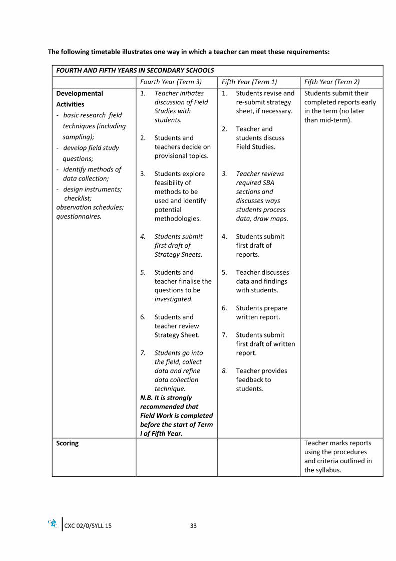
The following timetable illustrates one way in which a teacher can meet these requirements:
FOURTH AND FIFTH YEARS IN SECONDARY SCHOOLS
Fourth Year (Term 3) Fifth Year (Term 1) Fifth Year (Term 2)
Developmental
Activities
- basic research field
techniques (including
sampling);
- develop field study
questions;
- identify methods of data collection;
- design instruments; checklist; observation schedules; questionnaires.
1. Teacher initiates discussion of Field Studies with students.
2. Students and teachers decide on provisional topics.
3. Students explore
feasibility of methods to be used and identify potential methodologies.
4. Students submit
first draft of Strategy Sheets.
5. Students and teacher finalise the questions to be investigated.
6. Students and
teacher review Strategy Sheet.
7. Students go into
the field, collect data and refine data collection technique.
N.B. It is strongly recommended that Field Work is completed before the start of Term I of Fifth Year.
1. Students revise and re-submit strategy sheet, if necessary.
2. Teacher and students discuss Field Studies.
3. Teacher reviews
required SBA sections and discusses ways students process data, draw maps.
4. Students submit
first draft of reports.
5. Teacher discusses
data and findings with students.
6. Students prepare
written report. 7. Students submit
first draft of written report.
8. Teacher provides feedback to students.
Students submit their completed reports early in the term (no later than mid-term).
Scoring
Teacher marks reports using the procedures and criteria outlined in the syllabus.
CXC 02/0/SYLL 15 34
NOTES TO TEACHERS 1. For the Field Study, the teacher may choose the objective(s) from the syllabus or allow the
students to do so. The purpose of the fieldwork is to enhance the students’ understanding of the objectives. Students must be given an opportunity for self-directed learning in which they can assume responsibility for conducting an enquiry and presenting their findings. The quality of the candidates’ work can be improved by:
(a) stimulation - of interest in a problem; (b) guidance - to help the candidate become more aware of the strategies,
concepts, attitudes and principles which are involved in the enquiry.
2. The teacher may provide specific guidance by:
(a) encouraging the development of the skills required for illustrating data, drawing and labelling sketch maps and diagrams and using annotated photographs;
(b) advising on the format for the presentation of the report;
3. Careful planning and sequencing should be given to the timing of tasks or activities in order
to:
(a) avoid serious clashes with students’ workload in other subjects; (b) allow sufficient time for the students to acquire familiarity with appropriate fieldwork
techniques; (c) allow adequate time for individual supervision by the teacher; (d) ensure that there is sufficient time after students have completed their studies for
teachers to meet assessment and moderation deadlines. 4. The marking criteria should be applied consistently to the report of each student.
5. Fractional marks are NOT to be awarded.
Schools should retain copies of the individual mark sheets and the moderation sheet for the samples submitted to CXC.
CXC 02/0/SYLL 15 35
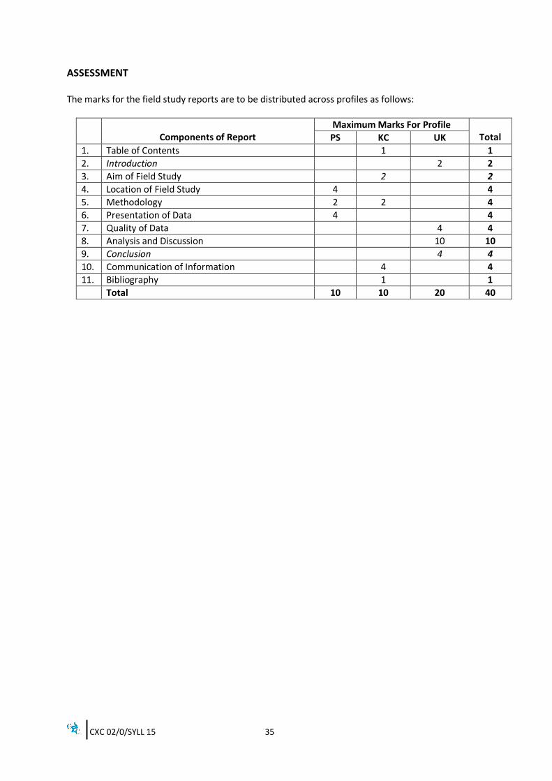
ASSESSMENT The marks for the field study reports are to be distributed across profiles as follows:
Components of Report
Maximum Marks For Profile Total PS KC UK
1. Table of Contents 1 1
2. Introduction 2 2
3. Aim of Field Study 2 2
4. Location of Field Study 4 4
5. Methodology 2 2 4
6. Presentation of Data 4 4
7. Quality of Data 4 4
8. Analysis and Discussion 10 10
9. Conclusion 4 4
10. Communication of Information 4 4
11. Bibliography 1 1
Total 10 10 20 40
CXC 02/0/SYLL 15 36
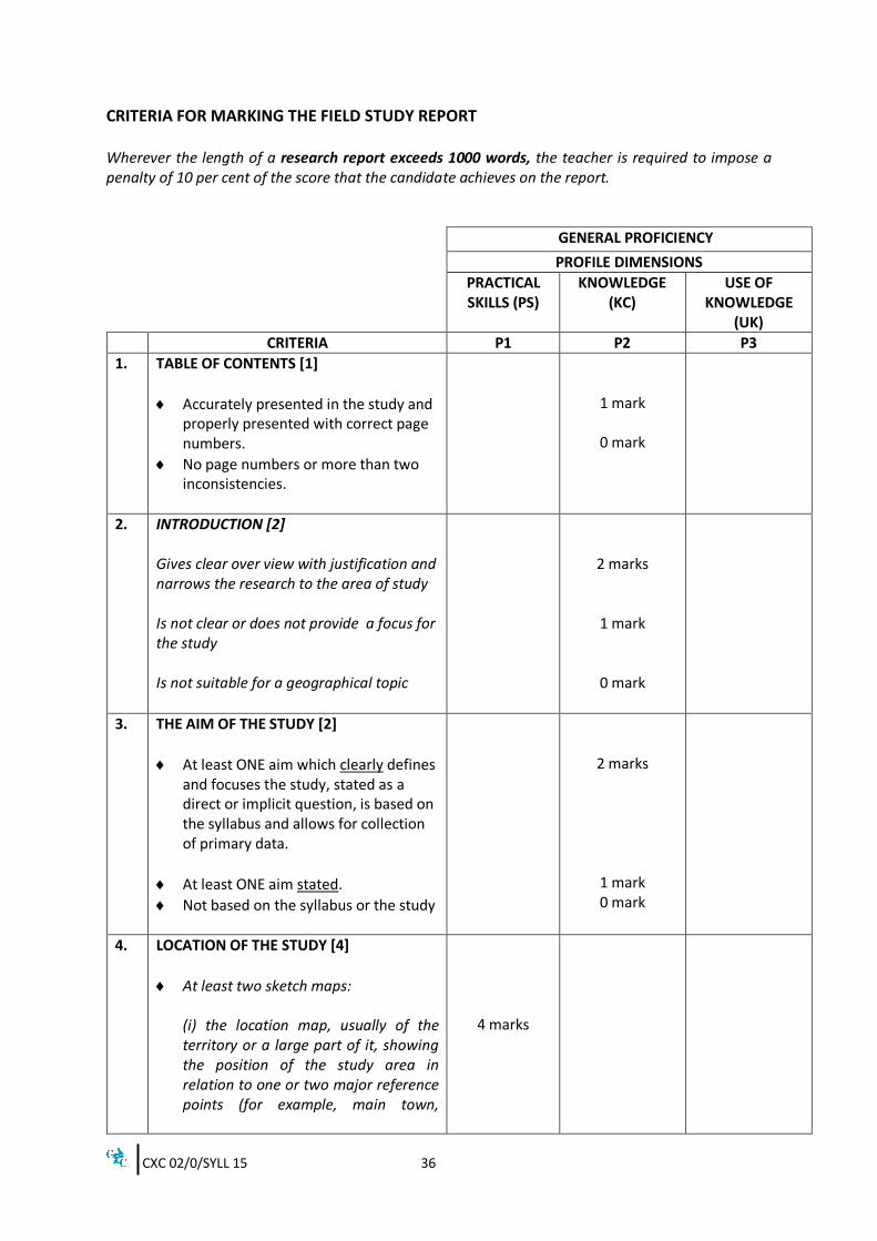
CRITERIA FOR MARKING THE FIELD STUDY REPORT Wherever the length of a research report exceeds 1000 words, the teacher is required to impose a penalty of 10 per cent of the score that the candidate achieves on the report.
GENERAL PROFICIENCY
PROFILE DIMENSIONS
PRACTICAL SKILLS (PS)
KNOWLEDGE (KC)
USE OF KNOWLEDGE
(UK)
CRITERIA P1 P2 P3
1. TABLE OF CONTENTS [1]
Accurately presented in the study and properly presented with correct page numbers.
No page numbers or more than two inconsistencies.
1 mark
0 mark
2. INTRODUCTION [2] Gives clear over view with justification and narrows the research to the area of study Is not clear or does not provide a focus for the study Is not suitable for a geographical topic
2 marks
1 mark
0 mark
3. THE AIM OF THE STUDY [2]
At least ONE aim which clearly defines and focuses the study, stated as a direct or implicit question, is based on the syllabus and allows for collection of primary data.
At least ONE aim stated.
Not based on the syllabus or the study
2 marks
1 mark 0 mark
4. LOCATION OF THE STUDY [4]
At least two sketch maps: (i) the location map, usually of the territory or a large part of it, showing the position of the study area in relation to one or two major reference points (for example, main town,
4 marks
CXC 02/0/SYLL 15 37
GENERAL PROFICIENCY
PROFILE DIMENSIONS
PRACTICAL SKILLS (PS)
KNOWLEDGE (KC)
USE OF KNOWLEDGE
(UK)
CRITERIA P1 P2 P3
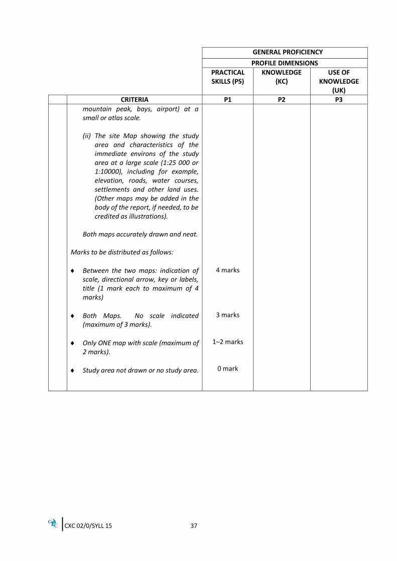
mountain peak, bays, airport) at a small or atlas scale. (ii) The site Map showing the study
area and characteristics of the immediate environs of the study area at a large scale (1:25 000 or 1:10000), including for example, elevation, roads, water courses, settlements and other land uses. (Other maps may be added in the body of the report, if needed, to be credited as illustrations).
Both maps accurately drawn and neat.
Marks to be distributed as follows:
Between the two maps: indication of scale, directional arrow, key or labels, title (1 mark each to maximum of 4 marks)
Both Maps. No scale indicated (maximum of 3 marks).
Only ONE map with scale (maximum of 2 marks).
Study area not drawn or no study area.
4 marks
3 marks
1–2 marks
0 mark
CXC 02/0/SYLL 15 38
GENERAL PROFICIENCY
PROFILE DIMENSIONS
PRACTICAL SKILLS (PS)
KNOWLEDGE (KC)
USE OF KNOWLEDGE
(UK)
CRITERIA P1 P2 P3
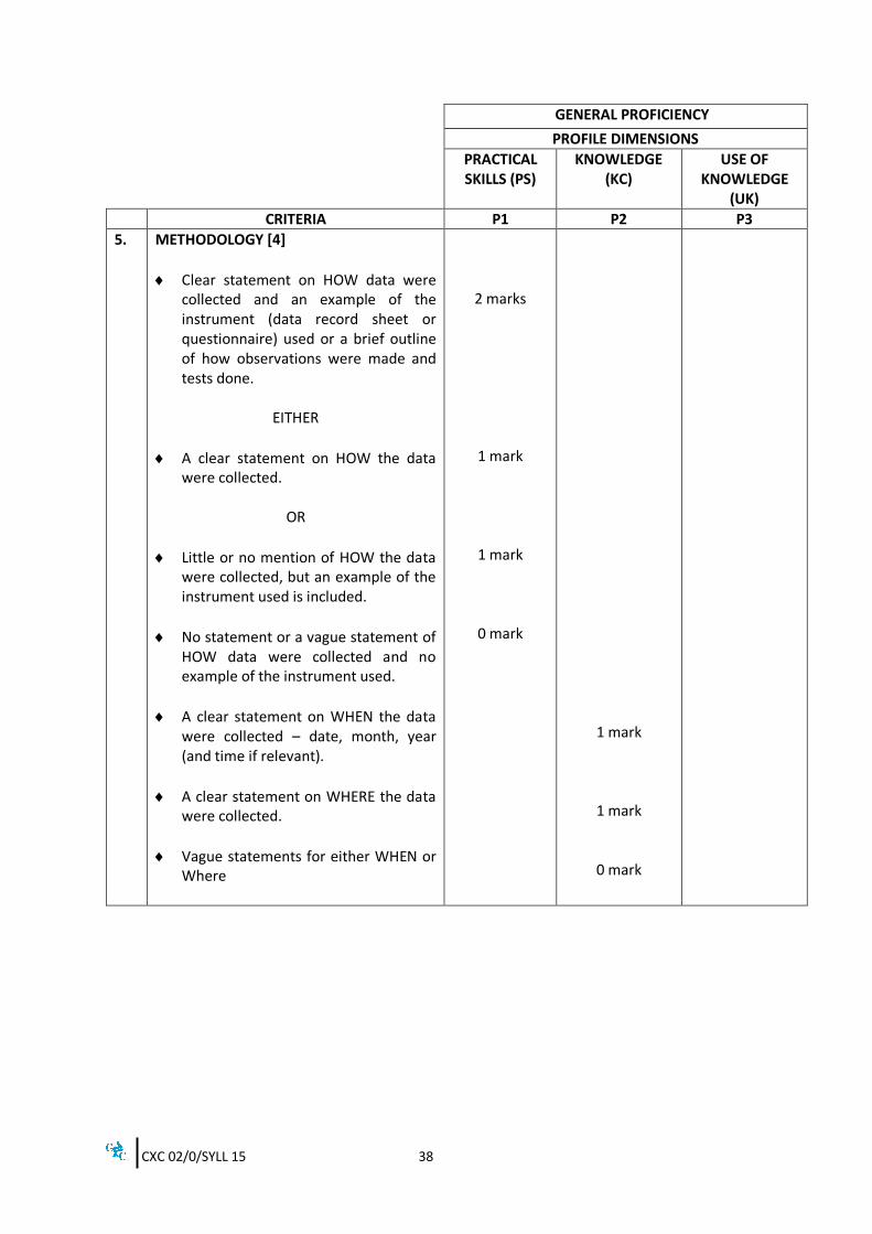
5. METHODOLOGY [4]
Clear statement on HOW data were collected and an example of the instrument (data record sheet or questionnaire) used or a brief outline of how observations were made and tests done.
EITHER
A clear statement on HOW the data were collected.
OR
Little or no mention of HOW the data were collected, but an example of the instrument used is included.
No statement or a vague statement of HOW data were collected and no example of the instrument used.
A clear statement on WHEN the data were collected – date, month, year (and time if relevant).
A clear statement on WHERE the data were collected.
Vague statements for either WHEN or Where
2 marks
1 mark
1 mark
0 mark
1 mark
1 mark
0 mark
CXC 02/0/SYLL 15 39
GENERAL PROFICIENCY
PROFILE DIMENSIONS
PRACTICAL SKILLS (PS)
KNOWLEDGE (KC)
USE OF KNOWLEDGE
(UK)
CRITERIA P1 P2 P3
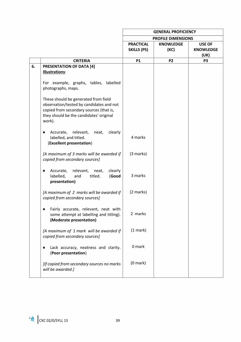
6.
PRESENTATION OF DATA [4] Illustrations: For example, graphs, tables, labelled photographs, maps. These should be generated from field observation/tested by candidates and not copied from secondary sources (that is, they should be the candidates’ original work).
Accurate, relevant, neat, clearly labelled, and titled.
(Excellent presentation) [A maximum of 3 marks will be awarded if copied from secondary sources]
Accurate, relevant, neat, clearly labelled, and titled. (Good presentation)
[A maximum of 2 marks will be awarded if copied from secondary sources]
Fairly accurate, relevant, neat with some attempt at labelling and titling). (Moderate presentation)
[A maximum of 1 mark will be awarded if copied from secondary sources]
Lack accuracy, neatness and clarity. (Poor presentation)
[If copied from secondary sources no marks will be awarded.]
4 marks
(3 marks)
3 marks
(2 marks)
2 marks
(1 mark)
0 mark
(0 mark)
CXC 02/0/SYLL 15 40
GENERAL PROFICIENCY
PROFILE DIMENSIONS
PRACTICAL SKILLS (PS)
KNOWLEDGE (KC)
USE OF KNOWLEDGE
(UK)
CRITERIA P1 P2 P3
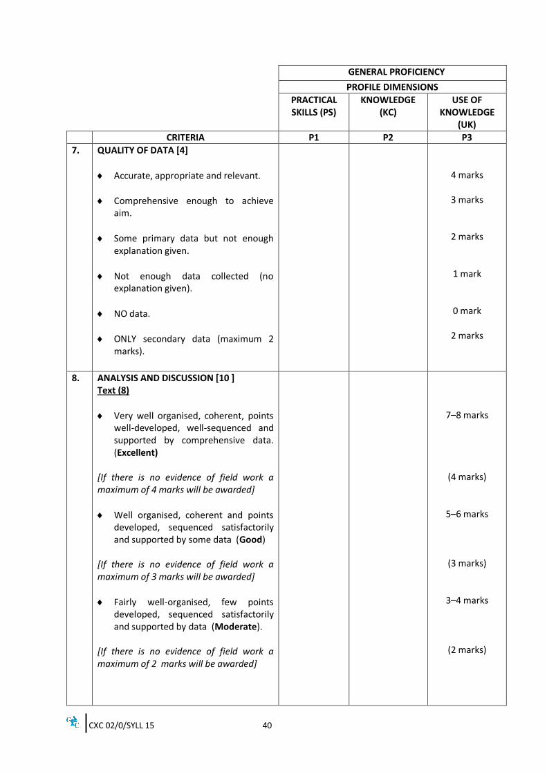
7. QUALITY OF DATA [4]
Accurate, appropriate and relevant.
Comprehensive enough to achieve aim.
Some primary data but not enough explanation given.
Not enough data collected (no explanation given).
NO data.
ONLY secondary data (maximum 2 marks).
4 marks
3 marks
2 marks
1 mark
0 mark
2 marks
8. ANALYSIS AND DISCUSSION [10 ] Text (8)
Very well organised, coherent, points well-developed, well-sequenced and supported by comprehensive data. (Excellent)
[If there is no evidence of field work a maximum of 4 marks will be awarded]
Well organised, coherent and points developed, sequenced satisfactorily and supported by some data (Good)
[If there is no evidence of field work a maximum of 3 marks will be awarded]
Fairly well-organised, few points developed, sequenced satisfactorily and supported by data (Moderate).
[If there is no evidence of field work a maximum of 2 marks will be awarded]
7–8 marks
(4 marks)
5–6 marks
(3 marks)
3–4 marks
(2 marks)
CXC 02/0/SYLL 15 41
GENERAL PROFICIENCY
PROFILE DIMENSIONS
PRACTICAL SKILLS (PS)
KNOWLEDGE (KC)
USE OF KNOWLEDGE
(UK)
CRITERIA P1 P2 P3
Shows little relevance or organisation, poor presentation of points, and points not supported by data. (Poor)
Integration of Illustrations (2)
Well integrated – discussed and placed appropriately near first reference.
Satisfactorily integrated – discussed not placed appropriately.
No integration – no reference to illustrations in text (they are mere decorations)
1–2 marks
2 marks
1 mark
0 mark
9. CONCLUSION [4]
Is related to the aim of the study, and provides a succinct summary consistent with the data obtained.
Is related to the aim of the study and provides a summary consistent with data obtained.
Shows little relation to the aim of the study.
4 marks
2–3 marks
0–1 mark
10. COMMUNICATION OF INFORMATION [4]
No grammatical errors or flaws and extensive use of appropriate geographical terms.
Some grammatical errors and good use of appropriate geographical terms.
Some grammatical errors and limited use of appropriate geographical terms.
4 marks
3 marks
2 marks
CXC 02/0/SYLL 15 42
GENERAL PROFICIENCY
PROFILE DIMENSIONS
PRACTICAL SKILLS (PS)
KNOWLEDGE (KC)
USE OF KNOWLEDGE
(UK)
CRITERIA P1 P2 P3
Numerous grammatical errors and poor use of appropriate geographical terms.
Numerous grammatical errors and no use of appropriate geographical terms.
1 mark
0 mark
11. BIBLIOGRAPHY [1]
Alphabetical order by author with title, publisher, place and date for at least two, relevant and up-to-date references
Fewer than two references or references written in an inconsistent manner
1 mark
0 mark
12. Penalty For Exceeding Word Limit -1 mark (max) -1 mark (max) -2 marks (max)
TOTAL 10 10 20
MODERATION OF SCHOOL-BASED ASSESSMENT School-Based Assessment Record Sheets are available online via the CXC’s website www.cxc.org. All School-Based Assessment Record of marks must be submitted online using the SBA data capture module of the Online Registration System (ORS). A sample of assignments will be requested by CXC for moderation purposes. These assignments will be reassessed by CXC Examiners who moderate the SBA. Teachers’ marks may be adjusted as a result of moderation. The Examiners’ comments will be sent to schools. All samples must be delivered to the specified marking venues by the stipulated deadlines. Copies of the students' assignments that are not submitted must be retained by the school until three months after publication by CXC of the examination results.
CXC 02/0/SYLL 15 43
GUIDELINES FOR THE CONDUCT OF THE PAPER 032, ALTERNATIVE TO SBA The Paper 032, Alternative to the SBA, assesses the same skills as the SBA itself. The questions are set to assess the skills that the candidates should demonstrate when carrying out a field study. Candidates are expected to: 1. formulate a research question or hypothesis;
2. design a strategy to collect relevant data by field research; 3. say how the field study will be conducted;
4. present data in tables or charts; 5. evaluate data collected with respect to a question or hypothesis;
6. make logical deductions or inferences supported by data; 7. draw conclusion with respect to the findings as indicated by question or hypothesis;
8. present a bibliography. Candidates may also be required to respond to scenes, situations or problems that are likely to occur in the conduct of a field study.
CXC 02/0/SYLL 15 44
RESOURCES
The following is a list of books and other printed material that might be used for teaching Geography for the CSEC Examinations. This list is by no means exhaustive or prescriptive but indicates sources that teachers and students could use as appropriate.
Abbott, P. Natural Disasters: Seventh Edition, United States: McGraw Hill, 2009.
Bleasdell, S. et al. A Photographic Geography of the Caribbean, Trinidad and Tobago: Caribbean Educational Publishers, 2009.
Bleasdell, S. et al. CSEC – New Integrated Geography, Trinidad and Tobago: Caribbean Educational Publishers, 2008.
Guinness, P. et al. Geography for CSEC, United Kingdom: Nelson Thornes, 2008.
James, K. J. et al. Geography for CSEC: Second Edition, United Kingdom: Nelson Thornes, 2008.
Johnston, R. J. et al. The Dictionary of Human Geography: Fifth Edition, Oxford: Wiley-Blackwell, 2011.
Lindsay, J. et al. Volcanic Hazard Atlas of the Lesser Antilles, Trinidad and Tobago, Seismic Research Unit of the University of the West Indies, 2005.
Mayhew, S. A Dictionary of Geography, Oxford: Oxford University Press, 2010.
Morrissey, M. Atlas for the Caribbean Examinations: Third Edition, London: Pearson Longman Education, 2011.
Nagle, G. and Spencer, K. AS AND A Level Geography through Diagrams, Oxford: Oxford University Press, 2005.
Niles, J. Modern Caribbean Geography, Oxford: Macmillan Caribbean, 2005.
Ottley, J. and Gentles, M. Reardon, G.J and Bidaisee, S.
Longman Geography for CSEC, United Kingdom: Pearson Longman, 2010. The Essential Guide to Map Reading, Singapore: Marshall Cavendish Education, 2005.
Ross, S. and Rocke, J. Essential Mapwork Skills for the Caribbean, United Kingdom: Nelson Thornes, 2013.
Ross, S. et al
Sealy, N.
Wilson, M.
Geography for CSEC – Caribbean Examinations Council Study Guide, United Kingdom: Nelson Thornes, 2012.
Geography for CSEC Examinations, London: Macmillan Caribbean Publishers, 2010.
The Caribbean Environment, Fully Revised Edition, Oxford: Oxford University Press, 2007.
CXC 02/0/SYLL 15 45
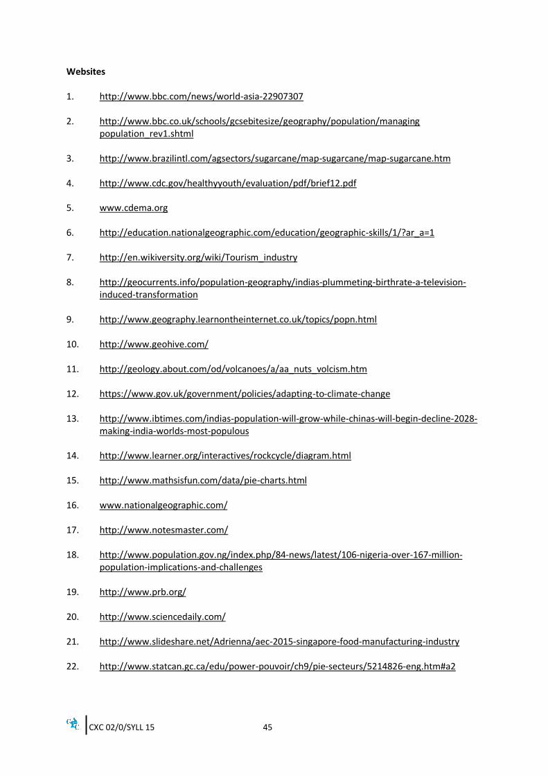
Websites 1. http://www.bbc.com/news/world-asia-22907307 2. http://www.bbc.co.uk/schools/gcsebitesize/geography/population/managing
population_rev1.shtml 3. http://www.brazilintl.com/agsectors/sugarcane/map-sugarcane/map-sugarcane.htm 4. http://www.cdc.gov/healthyyouth/evaluation/pdf/brief12.pdf
5. www.cdema.org
6. http://education.nationalgeographic.com/education/geographic-skills/1/?ar_a=1
7. http://en.wikiversity.org/wiki/Tourism_industry
8. http://geocurrents.info/population-geography/indias-plummeting-birthrate-a-television-
induced-transformation
9. http://www.geography.learnontheinternet.co.uk/topics/popn.html
10. http://www.geohive.com/
11. http://geology.about.com/od/volcanoes/a/aa_nuts_volcism.htm
12. https://www.gov.uk/government/policies/adapting-to-climate-change 13. http://www.ibtimes.com/indias-population-will-grow-while-chinas-will-begin-decline-2028-
making-india-worlds-most-populous
14. http://www.learner.org/interactives/rockcycle/diagram.html
15. http://www.mathsisfun.com/data/pie-charts.html
16. www.nationalgeographic.com/
17. http://www.notesmaster.com/
18. http://www.population.gov.ng/index.php/84-news/latest/106-nigeria-over-167-million-population-implications-and-challenges
19. http://www.prb.org/
20. http://www.sciencedaily.com/
21. http://www.slideshare.net/Adrienna/aec-2015-singapore-food-manufacturing-industry
22. http://www.statcan.gc.ca/edu/power-pouvoir/ch9/pie-secteurs/5214826-eng.htm#a2

CXC 02/0/SYLL 15 46
23. http://sugarcane.org/resourcelibrary/studies/evidences_on_sugarcane_expansion_and_agricultural_land_use_changes_in_brazil_1206.pdf
24. http://theworldoutline.com/2013/03/the-impact-of-chinas-one-child-policy/
25. https://www.wmo.int/pages/index_en.html 26. http://worldpopulationreview.com/countries/nigeria-population/ 27. http://www2.le.ac.uk/offices/ld/resources/numeracy/numerical-data
CXC 02/0/SYLL 15 47
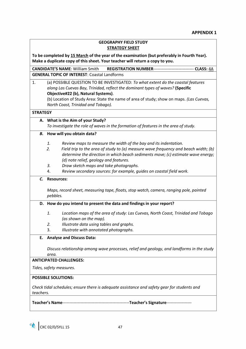
APPENDIX 1
GEOGRAPHY FIELD STUDY STRATEGY SHEET
To be completed by 15 March of the year of the examination (but preferably in Fourth Year). Make a duplicate copy of this sheet. Your teacher will return a copy to you.
CANDIDATE’S NAME: William Smith REGISTRATION NUMBER----------------------------- CLASS: 4A
GENERAL TOPIC OF INTEREST: Coastal Landforms
1. (a) POSSIBLE QUESTION TO BE INVESTIGATED: To what extent do the coastal features along Las Cuevas Bay, Trinidad, reflect the dominant types of waves? (Specific Objective#22 (b), Natural Systems). (b) Location of Study Area: State the name of area of study; show on maps. (Las Cuevas, North Coast, Trinidad and Tobago).
STRATEGY
A. What is the Aim of your Study? To investigate the role of waves in the formation of features in the area of study.
B. How will you obtain data?
1. Review maps to measure the width of the bay and its indentation. 2. Field trip to the area of study to (a) measure wave frequency and beach width; (b)
determine the direction in which beach sediments move; (c) estimate wave energy; (d) note relief, geology and features.
3. Draw sketch maps and take photographs. 4. Review secondary sources: for example, guides on coastal field work.
C. Resources: Maps, record sheet, measuring tape, floats, stop watch, camera, ranging pole, painted pebbles.
D. How do you intend to present the data and findings in your report?
1. Location maps of the area of study: Las Cuevas, North Coast, Trinidad and Tobago (as shown on the map). 2. Illustrate data using tables and graphs. 3. Illustrate with annotated photographs.
E. Analyse and Discuss Data: Discuss relationship among wave processes, relief and geology, and landforms in the study area.
ANTICIPATED CHALLENGES:
Tides, safety measures.
POSSIBLE SOLUTIONS:
Check tidal schedules; ensure there is adequate assistance and safety gear for students and teachers.
Teacher’s Name------------------------------------------------Teacher’s Signature------------------
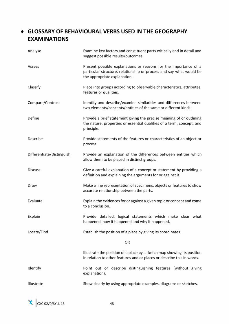
CXC 02/0/SYLL 15 48
GLOSSARY OF BEHAVIOURAL VERBS USED IN THE GEOGRAPHY EXAMINATIONS Analyse Examine key factors and constituent parts critically and in detail and
suggest possible results/outcomes. Assess Present possible explanations or reasons for the importance of a
particular structure, relationship or process and say what would be the appropriate explanation.
Classify Place into groups according to observable characteristics, attributes,
features or qualities. Compare/Contrast Identify and describe/examine similarities and differences between
two elements/concepts/entities of the same or different kinds. Define Provide a brief statement giving the precise meaning of or outlining
the nature, properties or essential qualities of a term, concept, and principle.
Describe Provide statements of the features or characteristics of an object or
process. Differentiate/Distinguish Provide an explanation of the differences between entities which
allow them to be placed in distinct groups. Discuss Give a careful explanation of a concept or statement by providing a
definition and explaining the arguments for or against it. Draw Make a line representation of specimens, objects or features to show
accurate relationship between the parts. Evaluate Explain the evidences for or against a given topic or concept and come
to a conclusion. Explain Provide detailed, logical statements which make clear what
happened, how it happened and why it happened. Locate/Find Establish the position of a place by giving its coordinates. OR
Illustrate the position of a place by a sketch map showing its position in relation to other features and or places or describe this in words.
Identify Point out or describe distinguishing features (without giving
explanation). Illustrate Show clearly by using appropriate examples, diagrams or sketches.
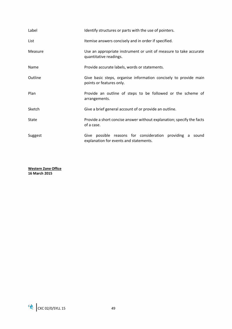
CXC 02/0/SYLL 15 49
Label Identify structures or parts with the use of pointers. List Itemise answers concisely and in order if specified. Measure Use an appropriate instrument or unit of measure to take accurate
quantitative readings. Name Provide accurate labels, words or statements. Outline Give basic steps, organise information concisely to provide main
points or features only. Plan Provide an outline of steps to be followed or the scheme of
arrangements. Sketch Give a brief general account of or provide an outline. State Provide a short concise answer without explanation; specify the facts
of a case. Suggest Give possible reasons for consideration providing a sound
explanation for events and statements.
Western Zone Office 16 March 2015
CARIBBEAN EXAMINATIONS COUNCIL
Car ibbean Secondary Educat ion Cer t if icat e ®
GEOGRAPHY
Specimen Papers and Mark Schemes/ Keys
Specimen Papers: - Paper 01 Paper 02 Paper 032
Mark Schemes and Keys: - Paper 01 Paper 02 Paper 032
TEST CODE 01225010SPEC 2015/01225010
C A R I B B E A N E X A M I N A T I O N S C O U N C I L
CARIBBEAN SECONDARY EDUCATION CERTIFICATE
EXAMINATION
GEOGRAPHY
SPECIMEN PAPER
Paper 01 – General Proficiency
1 hour 30 minutes
READ THE FOLLOWING INSTRUCTIONS CAREFULLY.
1. This test consists of 60 items. You will have 1 hour and 30 minutes to answer them.
2. In addition to this test booklet, you should have an answer sheet.
3. Each item in this test has four suggested answers lettered (A), (B), (C), (D). Read each item you are about to answer and decide which choice is best.
4. Onyouranswersheet,findthenumberwhichcorrespondstoyouritemandshadethespacehavingthesameletterastheansweryouhavechosen.Lookatthesampleitembelow.
SampleItem
Hurricanes in the Caribbean area are MOST likely to occur during SampleAnswer
(A) February–April ABCD (B) April–June (C) July–September (D) October–February
Thecorrectanswertothisitemis“July–September”,so(C)hasbeenshaded.
5. Ifyouwanttochangeyouranswer,eraseitcompletelyandfillinyournewchoice.
6. Whenyouaretoldtobegin,turnthepageandworkasquicklyandascarefullyasyoucan.Ifyou cannot answer an item, go on to the next one. You may return to that item later.
DO NOT TURN THIS PAGE UNTIL YOU ARE TOLD TO DO SO.
Copyright©2014CaribbeanExaminationsCouncilAll rights reserved.
01225010/SPEC 2015
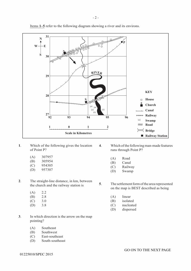
- 2 -
GO ON TO THE NEXT PAGE01225010/SPEC 2015
Items 1–5 refer to the following diagram showing a river and its environs.
1. Which of the following gives the location of Point P?
(A) 307957 (B) 305954 (C) 954305 (D) 957307
2. The straight-line distance, in km, between the church and the railway station is
(A) 2.2(B) 2.8(C) 3.0(D) 3.8
3. Inwhichdirectionisthearrowonthemappointing?
(A) Southeast (B) Southwest (C) East-southeast (D) South-southeast
4. Which of the following man-made features runs through Point P?
(A) Road (B) Canal (C) Railway (D) Swamp
5. ThesettlementformofthearearepresentedonthemapisBESTdescribedasbeing
(A) linear (B) isolated (C) nucleated (D) dispersed
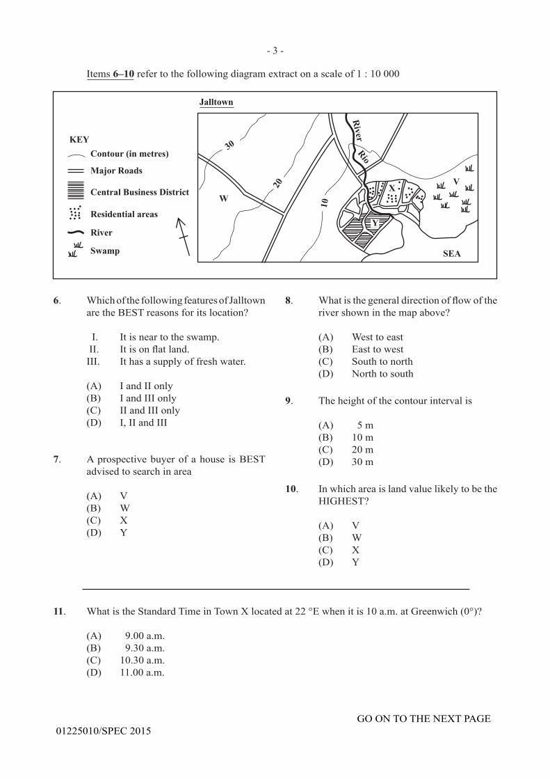
- 3 -
GO ON TO THE NEXT PAGE01225010/SPEC 2015
Items 6–10 refer to the following diagram extract on a scale of 1 : 10 000
6. WhichofthefollowingfeaturesofJalltownare the BEST reasons for its location?
I. Itisneartotheswamp. II. Itisonflatland. III. Ithasasupplyoffreshwater. (A) I and II only (B) I and III only (C) II and III only (D) I, II and III
7. Aprospectivebuyerofahouse isBESTadvised to search in area
(A) V (B) W (C) X (D) Y
8. Whatisthegeneraldirectionofflowoftherivershowninthemapabove?
(A) West to east (B) East to west (C) South to north (D) North to south
9. The height of the contour interval is
(A) 5 m (B) 10 m (C) 20 m (D) 30 m
10. In which area is land value likely to be the HIGHEST?
(A) V (B) W (C) X (D) Y
11. What is the Standard Time in Town X located at 22 °E when it is 10 a.m. at Greenwich (0°)?
(A) 9.00 a.m.(B) 9.30 a.m.(C) 10.30 a.m.(D) 11.00 a.m.
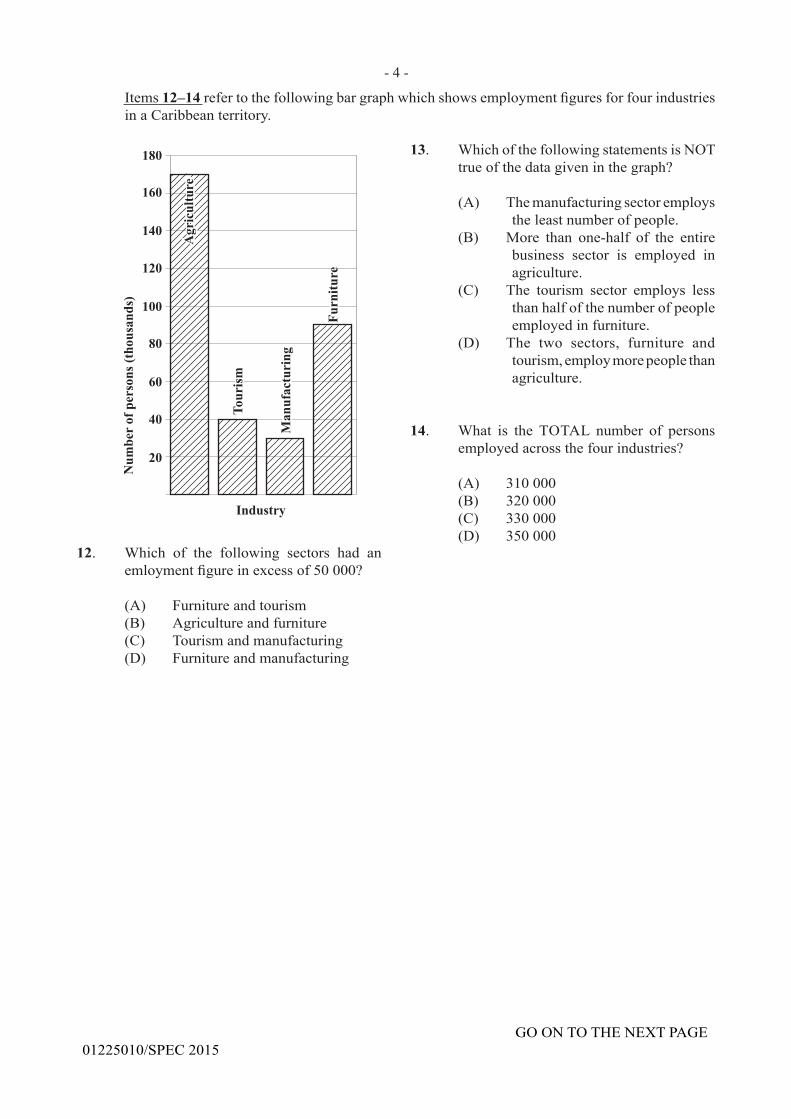
- 4 -
GO ON TO THE NEXT PAGE01225010/SPEC 2015
Items 12–14refertothefollowingbargraphwhichshowsemploymentfiguresforfourindustriesin a Caribbean territory.
12. Which of the following sectors had an emloymentfigureinexcessof50000?
(A) Furniture and tourism(B) Agriculture and furniture(C) Tourism and manufacturing
(D) Furniture and manufacturing
13. Which of the following statements is NOT trueofthedatagiveninthegraph?
(A) Themanufacturingsectoremploys
theleastnumberofpeople.(B) More than one-half of the entire
business sector is employed inagriculture.
(C) The tourism sector employs lessthanhalfofthenumberofpeopleemployedinfurniture.
(D) The two sectors, furniture and tourism,employmorepeoplethanagriculture.
14. What is the TOTAL number of personsemployedacrossthefourindustries?
(A) 310 000(B) 320 000(C) 330 000(D) 350 000
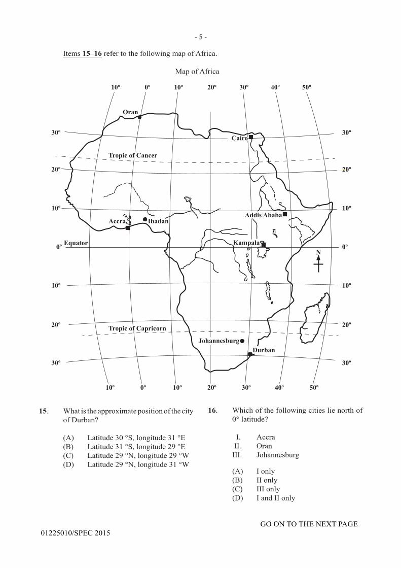
- 5 -
GO ON TO THE NEXT PAGE01225010/SPEC 2015
15. Whatistheapproximatepositionofthecityof Durban?
(A) Latitude 30 °S, longitude 31 °E (B) Latitude 31 °S, longitude 29 °E (C) Latitude 29 °N, longitude 29 °W (D) Latitude 29 °N, longitude 31 °W
Items 15–16refertothefollowingmapofAfrica.
16. Which of the following cities lie north of 0° latitude?
I. Accra II. OranIII. Johannesburg
(A) I only (B) II only (C) III only (D) I and II only
MapofAfrica
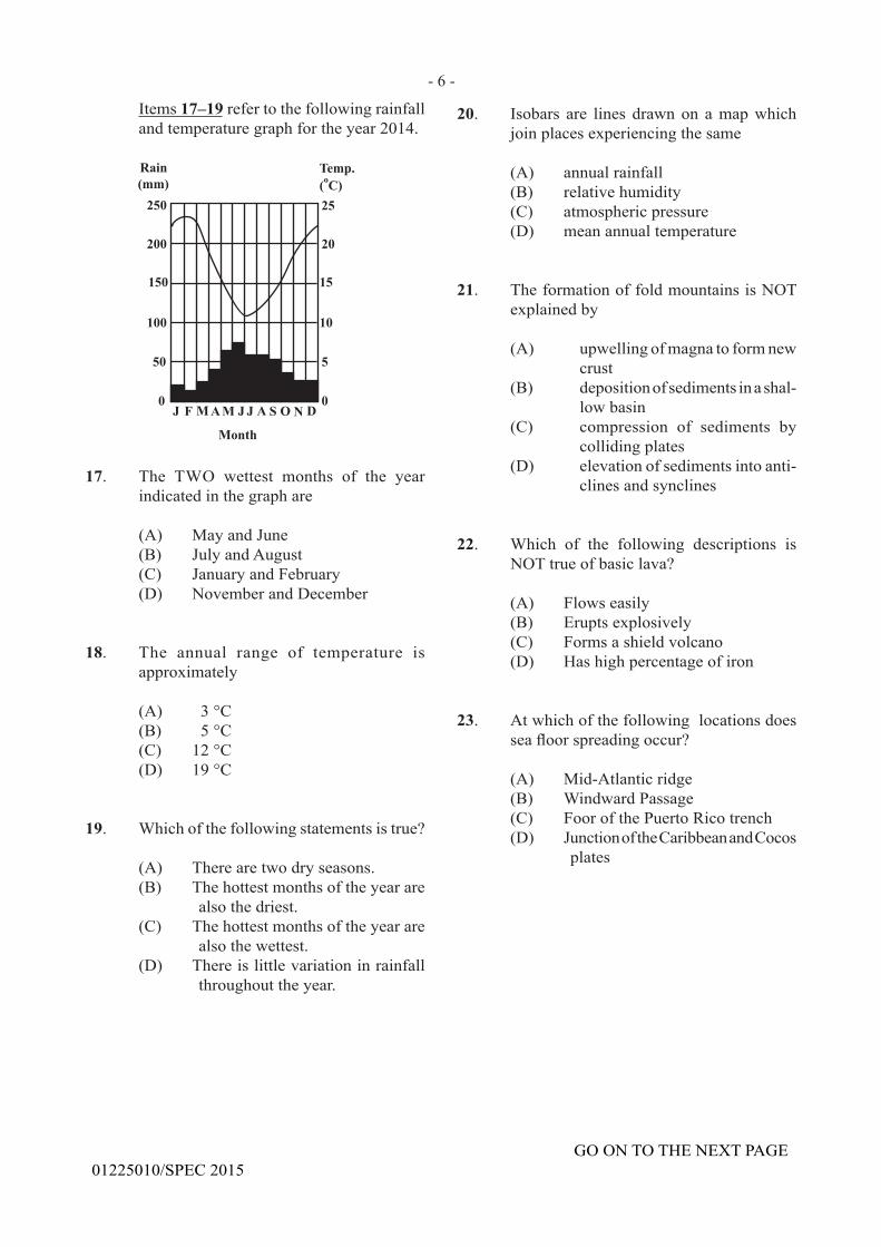
- 6 -
GO ON TO THE NEXT PAGE01225010/SPEC 2015
Items 17–19 refer to the following rainfall andtemperaturegraphfortheyear2014.
17. The TWO wettest months of the year indicatedinthegraphare
(A) MayandJune(B) JulyandAugust(C) JanuaryandFebruary(D) November and December
18. The annual range of temperature isapproximately
(A) 3 °C(B) 5 °C(C) 12 °C(D) 19 °C
19. Which of the following statements is true?
(A) There are two dry seasons.(B) The hottest months of the year are
also the driest.(C) The hottest months of the year are
also the wettest.(D) There is little variation in rainfall
throughout the year.
20. Isobars are lines drawnon amapwhichjoinplacesexperiencingthesame
(A) annual rainfall (B) relative humidity (C) atmosphericpressure (D) meanannualtemperature
21. The formation of fold mountains is NOT explainedby
(A) upwellingofmagnatoformnewcrust
(B) depositionofsedimentsinashal-low basin
(C) compression of sediments bycollidingplates
(D) elevation of sediments into anti-clines and synclines
22. Which of the following descriptions isNOT true of basic lava?
(A) Flows easily (B) Eruptsexplosively (C) Forms a shield volcano (D) Hashighpercentageofiron
23. At which of the following locations does seafloorspreadingoccur?
(A) Mid-Atlantic ridge(B) Windward Passage(C) Foor of the Puerto Rico trench(D) JunctionoftheCaribbeanandCocos
plates
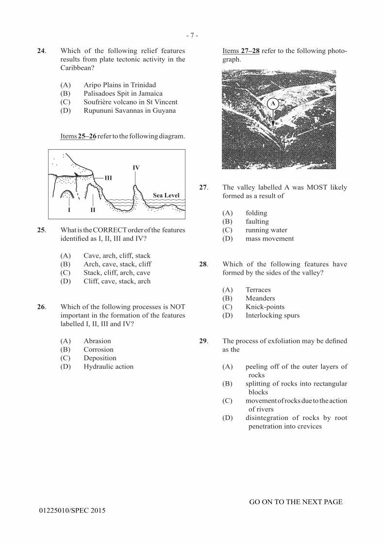
- 7 -
GO ON TO THE NEXT PAGE01225010/SPEC 2015
24. Which of the following relief features resultsfromplate tectonicactivity in theCaribbean?
(A) AripoPlainsinTrinidad(B) PalisadoesSpitinJamaica(C) Soufrière volcano in St Vincent(D) RupununiSavannasinGuyana
Items 25–26 refer to the following diagram.
25. What is the CORRECT order of the features identifiedasI,II,IIIandIV?
(A) Cave, arch, cliff, stack(B) Arch, cave, stack, cliff(C) Stack, cliff, arch, cave(D) Cliff, cave, stack, arch
26. WhichofthefollowingprocessesisNOTimportantintheformationofthefeatureslabelled I, II, III and IV?
(A) Abrasion(B) Corrosion(C) Deposition(D) Hydraulic action
Items 27–28refertothefollowingphoto-graph.
27. The valley labelled A was MOST likely formed as a result of
(A) folding(B) faulting(C) running water(D) mass movement
28. Which of the following features have formed by the sides of the valley?
(A) Terraces (B) Meanders (C) Knick-points (D) Interlockingspurs
29. Theprocessofexfoliationmaybedefinedas the
(A) peelingoffof theouter layersofrocks
(B) splittingofrocksintorectangularblocks
(C) movement of rocks due to the action of rivers
(D) disintegration of rocks by root penetrationintocrevices
- 8 -
GO ON TO THE NEXT PAGE01225010/SPEC 2015
30. Which of the following conditions may result from man’s utilization of the natural environment?
I. Soil erosion II. PollutionIII. Depletionofnaturalresources
(A) I and II only(B) I and III only(C) II and III only(D) I, II and III
31. Which of the following statements is NOT true about waves?
(A) They are caused by wind blowing
over the surface of the water.(B) Onnearingthebeach,thespeedof
wavesslackensand the topsarethrown forward.
(C) On approaching the coast, thebody of water forming the waves increasesrapidly.
(D) The stronger the wind and the greaterthefetch,themorepower-ful the waves are.
32. It is MOST likely that recent hurricanes in the Caribbean have caused fewer deaths because
(A) families no longer live in unsafe areas
(B) many hurricanes have occurred during the day
(C) themajorityofthepopulationgoesto storm shelters
(D) therehavebeenimprovedforecastsof hurricane tracks
33. Theprocessbywhichwatervapourcoolsandformswaterdropletsistermed
(A) convection (B) evaporation(C) precipitation(D) condensation
34. Which of the following features is the MOST important difference betweenweather and climate?
(A) Time (B) Rainfall(C) Location(D) Temperature
35. TropicaloreasterlywavesintheCaribbeanare MOST common during the months
(A) JunetoJuly (B) May to October (C) December to March (D) November to December
36. Thetemperaturesuddenlydropsandwindspeedincreases;theskygraduallybecomesovercast and there is a slight drizzle.
Whatweathersystemproducestheweatherconditions described above?
(A) Cold front (B) Hurricane (C) Easterlywave/tropicalwave
(D) Inter-tropicalconvergencezone
37. Which of the following processes is atwork in the concentration of minerals in thelowerlayersofasoilprofile?
(A) Erosion (B) Leaching (C) Capillarity (D) Illuviation
38. Basic lava extruded on the surface tends to form
(A) sills (B) dykes(C) shields(D) domes
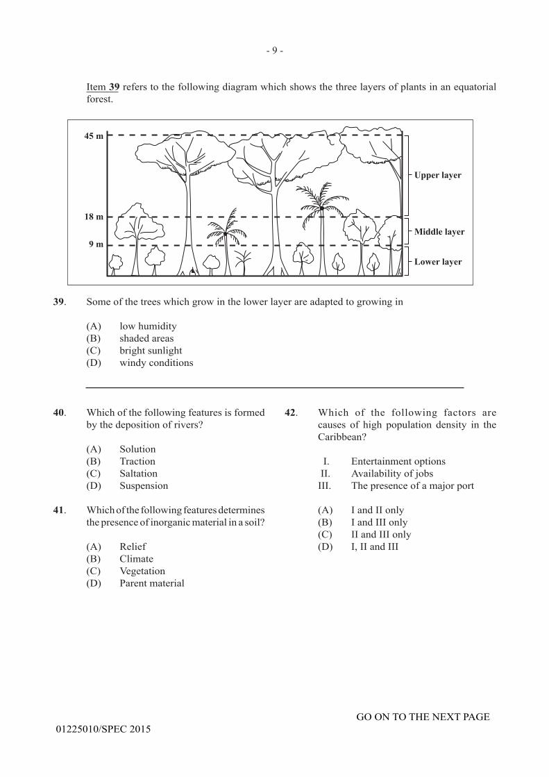
- 9 -
GO ON TO THE NEXT PAGE01225010/SPEC 2015
39. Someofthetreeswhichgrowinthelowerlayerareadaptedtogrowingin
(A) low humidity (B) shaded areas (C) bright sunlight (D) windy conditions
Item 39referstothefollowingdiagramwhichshowsthethreelayersofplantsinanequatorialforest.
40. Which of the following features is formed bythedepositionofrivers?
(A) Solution (B) Traction (C) Saltation (D) Suspension
41. Which of the following features determines thepresenceofinorganicmaterialinasoil?
(A) Relief (B) Climate (C) Vegetation (D) Parent material
42. Which of the following factors are causes of high population density in theCaribbean?
I. Entertainmentoptions II. Availability of jobsIII. Thepresenceofamajorport
(A) I and II only(B) I and III only(C) II and III only(D) I, II and III
- 10 -
GO ON TO THE NEXT PAGE01225010/SPEC 2015
47. Which of the following statements is true of subsistence farming?
(A) Individualfarmsarequitesmall.(B) Yieldsperfarmaregenerallyhigh.(C) Large amounts of fertilizers are
used on the farm.(D) Cropcultivationisnotasimportant
as animal rearing.
48. CommercialpastoralfarminginCaribbeanterritories isLEAST likely to takeplacenear urban settlements because
(A) the soil in these locations is infertile(B) there are no large areas of land for
grazing(C) there is easy transmission of animal
diseases to humans(D) the size of the population is too
smalltosupportthisactivity
49. Anincreaseintheproportionofacountry'spopulationlivingintownsisreferredtoas
(A) urbanization (B) urbansprawl (C) sub-urbanization (D) populationgrowth
50. RapidurbanizationinCaribbeancountriesusually results in
(A) housing shortages in the cities (B) increased employment in the
cities (C) decreased foreign exchange earn-
ings(D) improvement in the standard of
living
51. Afarmerisinvolvedinplantingsugarcanewhichhesuppliestoafactory.Inwhichofthe following industries is he involved?
(A) Tertiary(B) Secondary(C) Primary(D) Quaternary
43. Which of the following areas would have the HIGHEST populationdensity in thedaytime?
(A) Asquattersettlement (B) Aruralfishingvillage (C) An urban residential community (D) An urban commercial centre
44. The following table shows birth and death rates for Country A in 2 000.
Birth Rate Death Rate per 1000 per 1000
20 15
For 2 000, the natural increase in Country A is
(A) 0.005% (B) 0.5% (C) 3.5% (D) 5.0%
45. WhichofthefollowingtermsBESTexplainstherapidgrowthinsizeoftheLARGESTurban centres in the Caribbean?
(A) Anageingpopulation(B) An increase in the number of
immigrants(C) High birth rates and low infant
mortality(D) Themigrationofpersonsfromrural
areas
46. Whichofthefollowingresultsfromtropicaldeforestation?
(A) Lumbering(B) Lossofflora(C) Increased fauna(D) Increased underground water
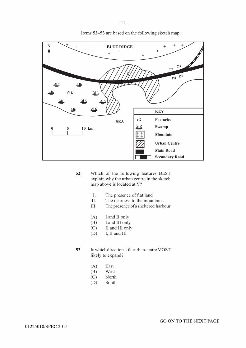
- 11 -
GO ON TO THE NEXT PAGE01225010/SPEC 2015
Items 52–53arebasedonthefollowingsketchmap.
52. Which of the following features BEST explainwhytheurbancentreinthesketchmapaboveislocatedatY?
I. Thepresenceofflatland II. The nearness to the mountainsIII. Thepresenceofashelteredharbour
(A) I and II only(B) I and III only(C) II and III only(D) I, II and III
53. In which direction is the urban centre MOST likelytoexpand?
(A) East(B) West(C) North(D) South
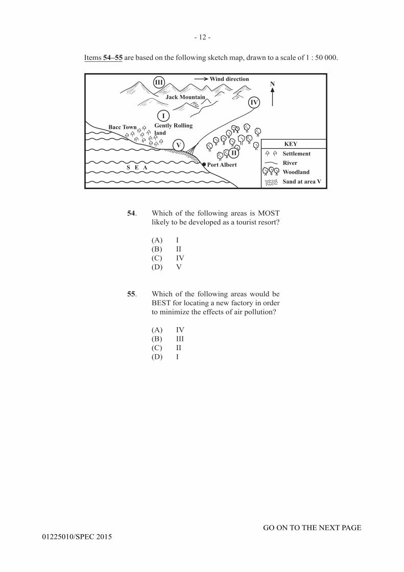
- 12 -
GO ON TO THE NEXT PAGE01225010/SPEC 2015
Items 54–55arebasedonthefollowingsketchmap,drawntoascaleof1:50000.
54. Which of the following areas is MOST likelytobedevelopedasatouristresort?
(A) I(B) II(C) IV(D) V
55. Which of the following areas would be BEST for locating a new factory in order tominimizetheeffectsofairpollution?
(A) IV(B) III(C) II(D) I
56. In a mountainous region severely eroded becauseofdeforestation,whatarethepos-sible soil conservation methods that could beputinplace?
(A) Stripcroppingandcroprotation(B) Agro-forestryandstripcropping(C) Croprotationandreafforestation(D) Reafforestation and contour
ploughing
57. Agricultureisanimportanteconomicactiv-ity in the Caribbean because
(A) it is heavily mechanized(B) itemploysasignificantpercentage
ofpeople(C) governmentallocatesasignificant
portionofitsbudgettothesector(D) itaccountsforasignificantportion
of the foreign exchange earnings
58. Many garment industries in the Caribbean are closing business MAINLY because
(A) the demand for clothing is falling(B) cheaper imports are entering the
region(C) the rates for wages are lower in the
region(D) many women refuse to work in the
factories
59. In the long-term, volcanic activity can be beneficialtoacountryby
I. causingpeopletorelocatetonewareas in the country
II. providingsourcesofenergytobeused for electricity needs
III. bringingnewmaterialstotheearth'ssurfacewhichproducerichsoils
(A) I only(B) I and II only(C) I and III only(D) II and III only
60. Inadvanceoftheapproachofahurricane,risk to lives can be reduced by
I. relocatingpeopletosheltersII. encouragingpeopletostockupon
freshsuppliesIII. evacuating people living in low-
lying areas
(A) I and II only(B) I and III only(C) II and III only(D) I, II and III
END OF TEST
01225010/SPECIMEN
- 13 -
C A R I B B E A N E X A M I N A T I O N S C O U N C I L
CARIBBEAN SECONDARY EDUCATION CERTIFICATE
EXAMINATION
GEOGRAPHYGENERAL PROFICIENCY
SPECIMEN 2015
Item No. Key1 D2 B3 A4 B5 A6 C7 C8 D9 B10 D11 D12 B13 D14 C15 A16 C17 A18 C19 B20 C21 A22 B23 A24 C25 A26 C27 C28 D29 A30 D
Item No. Key31 C32 D33 D34 A35 B36 A37 D38 C39 B40 B41 D42 C43 D44 A45 D46 B47 A48 B49 A50 A51 C52 B53 A54 D55 A56 D57 D58 B59 D60 B
C A R I B B E A N E X A M I N A T I O N S C O U N C I L
CARIBBEAN SECONDARY EDUCATION CERTIFICATE®
EXAMINATION
FILL IN ALL THE INFORMATION REQUESTED CLEARLY IN CAPITAL LETTERS.
TEST CODE
SUBJECT
PROFICIENCY
REGISTRATION NUMBER
SCHOOL/CENTRE NUMBER
NAME OF SCHOOL/CENTRE
CANDIDATE’S FULL NAME (FIRST, MIDDLE, LAST)
DATE OF BIRTH D D M M Y Y Y Y
SIGNATURE __________________________________________________
‘‘*’’Barcode Area”*”Sequential Bar Code
‘‘*’’Barcode Area”*”Front Page Bar Code
‘‘*’’B
arco
de A
rea”
*”C
urre
nt B
ar C
ode
0 1 2 2 5 0 2 0
GEOGRAPHY – Paper 02
GENERAL

DO NOT
WRIT
E O
NTH
IS P
AGE
TEST CODE 01225020/SPECFORM TP 2015/SPEC MAY/JUNE 2015
C A R I B B E A N E X A M I N A T I O N S C O U N C I L
CARIBBEAN SECONDARY EDUCATION CERTIFICATE®
EXAMINATION
GEOGRAPHY
Paper 02 – General Proficiency
2 hours 30 minutes
SPECIMEN PAPER
READ THE FOLLOWING INSTRUCTIONS CAREFULLY.
1. This paper consists of FOUR compulsory questions.
2. Write your answers in the spaces provided in this booklet.
3. Do NOT write in the margins.
4. You may use a silent, non-programmable calculator to answer questions.
5. You may use geometrical instruments.
6. If you need to rewrite any answer and there is not enough space to do so on the original page, you must use the extra lined page(s) provided at the back of this booklet. Remember to draw a line through your original answer.
7. If you use the extra page(s) you MUST write the question number clearly in the box provided at the top of the extra page(s) and, where relevant, include the question part beside the answer.
DO NOT TURN THIS PAGE UNTIL YOU ARE TOLD TO DO SO.
Copyright © 2014 Caribbean Examinations CouncilAll rights reserved.
01225020/F 2015/SPEC‘‘*’’Barcode Area”*”Sequential Bar Code
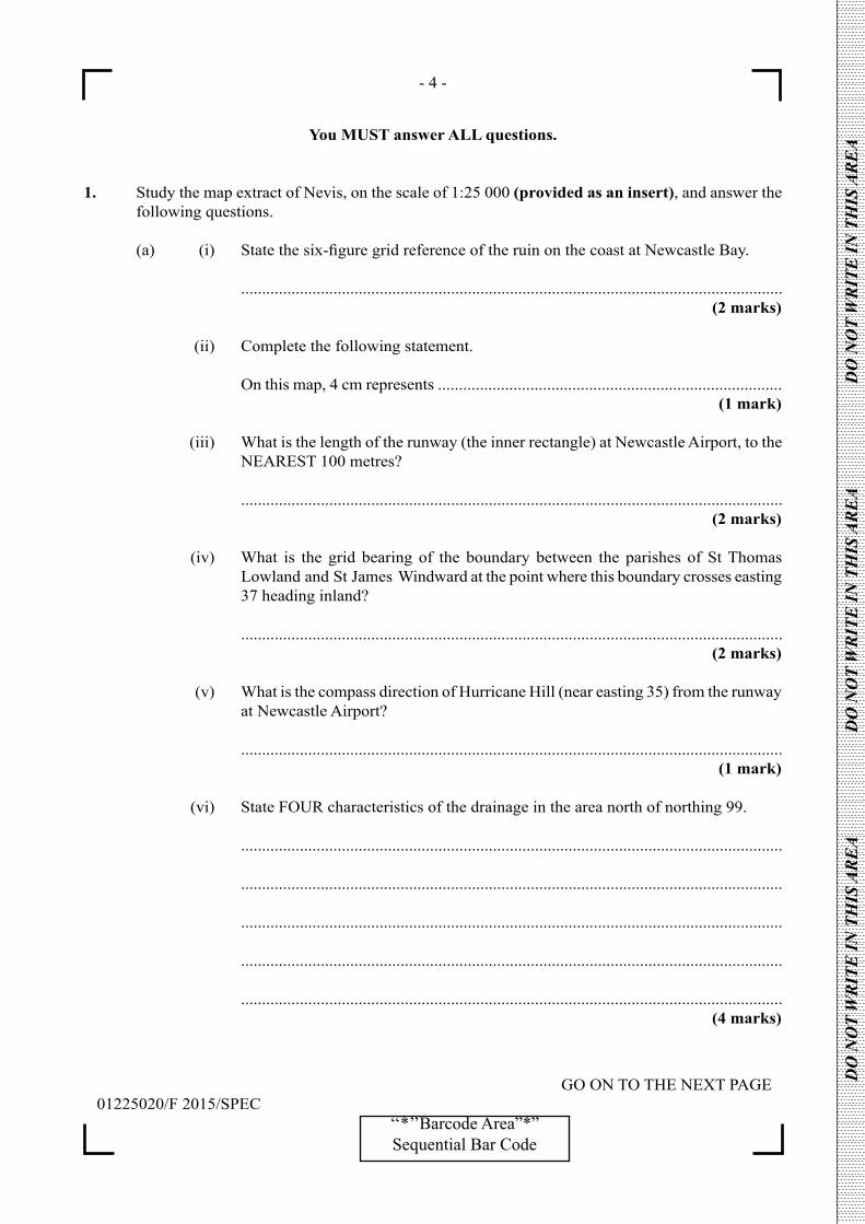
- 4 -
GO ON TO THE NEXT PAGE01225020/F 2015/SPEC
‘‘*’’Barcode Area”*”Sequential Bar Code
DO
NO
T W
RIT
E IN
TH
IS A
RE
A
DO
NO
T W
RIT
E IN
TH
IS A
RE
A
DO
NO
T W
RIT
E IN
TH
IS A
RE
A
You MUST answer ALL questions.
1. Study the map extract of Nevis, on the scale of 1:25 000 (provided as an insert), and answer the following questions.
(a) (i) Statethesix-figuregridreferenceoftheruinonthecoastatNewcastleBay.
................................................................................................................................. (2 marks)
(ii) Complete the following statement.
On this map, 4 cm represents .................................................................................. (1 mark)
(iii) What is the length of the runway (the inner rectangle) at Newcastle Airport, to the NEAREST 100 metres?
................................................................................................................................. (2 marks)
(iv) What is the grid bearing of the boundary between the parishes of St Thomas Lowland and St James Windward at the point where this boundary crosses easting 37 heading inland?
................................................................................................................................. (2 marks)
(v) What is the compass direction of Hurricane Hill (near easting 35) from the runway at Newcastle Airport?
................................................................................................................................. (1 mark)
(vi) State FOUR characteristics of the drainage in the area north of northing 99.
.................................................................................................................................
.................................................................................................................................
.................................................................................................................................
.................................................................................................................................
................................................................................................................................. (4 marks)
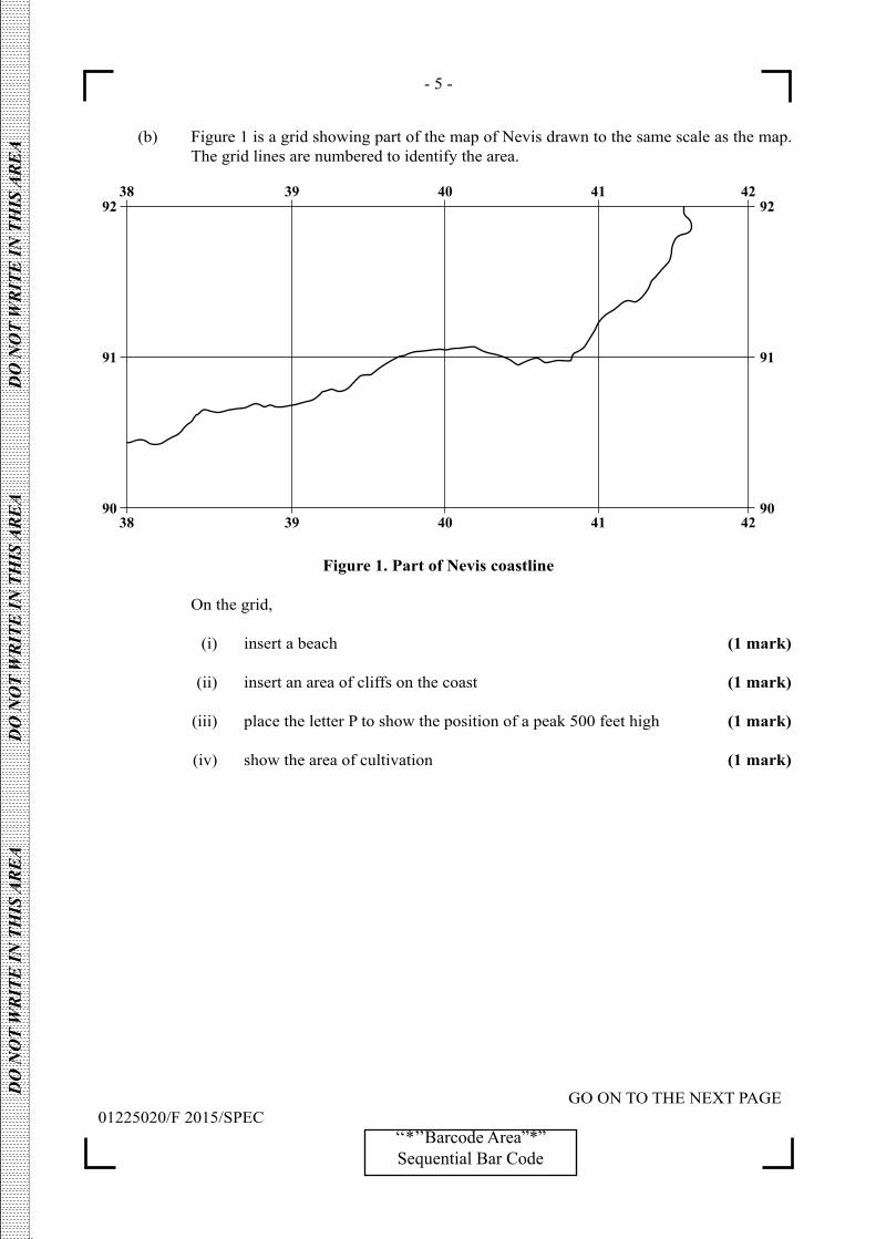
- 5 -
GO ON TO THE NEXT PAGE01225020/F 2015/SPEC
‘‘*’’Barcode Area”*”Sequential Bar Code
DO
NO
T W
RIT
E IN
TH
IS A
RE
A
DO
NO
T W
RIT
E IN
TH
IS A
RE
A
DO
NO
T W
RIT
E IN
TH
IS A
RE
A
(b) Figure 1 is a grid showing part of the map of Nevis drawn to the same scale as the map. The grid lines are numbered to identify the area.
92
91
90
92
91
9038 39 40 41 42
38 39 40 41 42
Figure 1. Part of Nevis coastline
On the grid,
(i) insert a beach (1 mark)
(ii) insert an area of cliffs on the coast (1 mark)
(iii) place the letter P to show the position of a peak 500 feet high (1 mark)
(iv) show the area of cultivation (1 mark)

- 6 -
GO ON TO THE NEXT PAGE01225020/F 2015/SPEC
‘‘*’’Barcode Area”*”Sequential Bar Code
DO
NO
T W
RIT
E IN
TH
IS A
RE
A
DO
NO
T W
RIT
E IN
TH
IS A
RE
A
DO
NO
T W
RIT
E IN
TH
IS A
RE
A
(c) Using evidence from the map, give THREE reasons to explain the distribution of the areas of cultivation and plantation in Nevis.
.............................................................................................................................................
.............................................................................................................................................
......................................................................................................... ....................................
.............................................................................................................................................
.............................................................................................................................................
......................................................................................................... .................................... (6 marks)
(d) List THREE features of the relief around Charlestown between northings 94 and 95 and eastings 32 and 34.
.............................................................................................................................................
.............................................................................................................................................
......................................................................................................... ....................................
.............................................................................................................................................
.............................................................................................................................................
......................................................................................................... .................................... (3 marks)
Total 25 marks
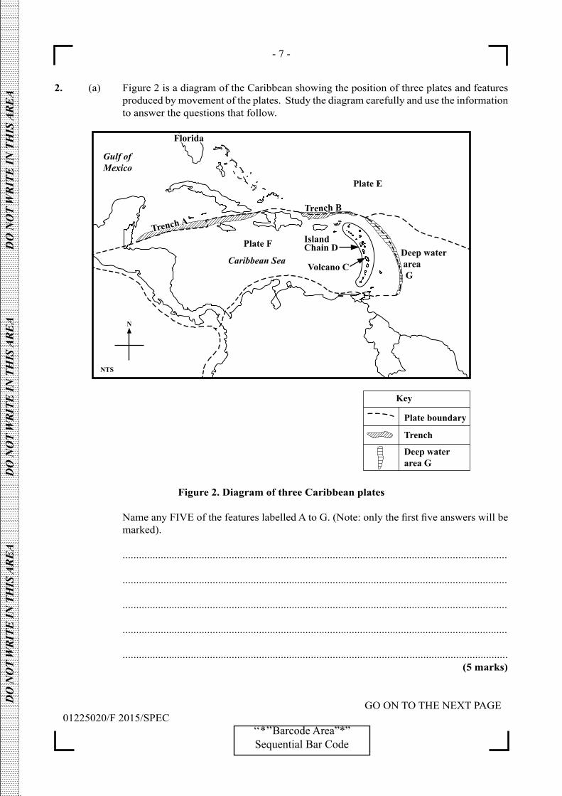
- 7 -
GO ON TO THE NEXT PAGE01225020/F 2015/SPEC
‘‘*’’Barcode Area”*”Sequential Bar Code
DO
NO
T W
RIT
E IN
TH
IS A
RE
A
DO
NO
T W
RIT
E IN
TH
IS A
RE
A
DO
NO
T W
RIT
E IN
TH
IS A
RE
A
2. (a) Figure 2 is a diagram of the Caribbean showing the position of three plates and features produced by movement of the plates. Study the diagram carefully and use the information to answer the questions that follow.
Figure 2. Diagram of three Caribbean plates
NameanyFIVEofthefeatureslabelledAtoG.(Note:onlythefirstfiveanswerswillbemarked).
.............................................................................................................................................
.............................................................................................................................................
.............................................................................................................................................
.............................................................................................................................................
......................................................................................................... .................................... (5 marks)

- 8 -
GO ON TO THE NEXT PAGE01225020/F 2015/SPEC
‘‘*’’Barcode Area”*”Sequential Bar Code
DO
NO
T W
RIT
E IN
TH
IS A
RE
A
DO
NO
T W
RIT
E IN
TH
IS A
RE
A
DO
NO
T W
RIT
E IN
TH
IS A
RE
A
(b) (i) Describe ONE way in which oceanic trenches can be formed.
.................................................................................................................................
.................................................................................................................................
.................................................................................................................................
.................................................................................................................................
.................................................................................................................................
.................................................................................................................................
................................................................................................................................. (4 marks)
(ii) Describe ONE way in which a volcano can be formed.
.................................................................................................................................
.................................................................................................................................
.................................................................................................................................
.................................................................................................................................
.................................................................................................................................
.................................................................................................................................
................................................................................................................................. (4 marks)

- 9 -
GO ON TO THE NEXT PAGE01225020/F 2015/SPEC
‘‘*’’Barcode Area”*”Sequential Bar Code
DO
NO
T W
RIT
E IN
TH
IS A
RE
A
DO
NO
T W
RIT
E IN
TH
IS A
RE
A
DO
NO
T W
RIT
E IN
TH
IS A
RE
A
(c) (i) ExplainTHREEconditionswhichinfluencetheformationofadeltaonthecoast.
.................................................................................................................................
.................................................................................................................................
.................................................................................................................................
.................................................................................................................................
.................................................................................................................................
.................................................................................................................................
.................................................................................................................................
.................................................................................................................................
.................................................................................................................................
.................................................................................................................................
.................................................................................................................................
.................................................................................................................................
.................................................................................................................................
.................................................................................................................................
................................................................................................................................. (6 marks)

- 10 -
GO ON TO THE NEXT PAGE01225020/F 2015/SPEC
‘‘*’’Barcode Area”*”Sequential Bar Code
DO
NO
T W
RIT
E IN
TH
IS A
RE
A
DO
NO
T W
RIT
E IN
TH
IS A
RE
A
DO
NO
T W
RIT
E IN
TH
IS A
RE
A
(ii) Outline TWO conditions for the formation of a headland.
.................................................................................................................................
.................................................................................................................................
.................................................................................................................................
.................................................................................................................................
.................................................................................................................................
.................................................................................................................................
.................................................................................................................................
.................................................................................................................................
.................................................................................................................................
.................................................................................................................................
.................................................................................................................................
.................................................................................................................................
.................................................................................................................................
.................................................................................................................................
.................................................................................................................................
.................................................................................................................................
.................................................................................................................................
.................................................................................................................................
.................................................................................................................................
.................................................................................................................................
.................................................................................................................................
.................................................................................................................................
................................................................................................................................. (6 marks)
Total 25 marks

- 11 -
GO ON TO THE NEXT PAGE01225020/F 2015/SPEC
‘‘*’’Barcode Area”*”Sequential Bar Code
DO
NO
T W
RIT
E IN
TH
IS A
RE
A
DO
NO
T W
RIT
E IN
TH
IS A
RE
A
DO
NO
T W
RIT
E IN
TH
IS A
RE
A
3. (a) In the space provided below, draw a sketch map of a CARICOM country and put in the location of ONE area where a natural resource, used for commercial purposes, is found.
(5 marks) (b) (i) DescribehowTWOfactorshaveinfluencedthelocationofONEofthefollowing
primary industries in the Caribbean.
• Bauxite • Oilandnaturalgas
.................................................................................................................................
.................................................................................................................................
.................................................................................................................................
.................................................................................................................................
.................................................................................................................................
.................................................................................................................................
................................................................................................................................. (4 marks)
- 12 -
GO ON TO THE NEXT PAGE01225020/F 2015/SPEC
‘‘*’’Barcode Area”*”Sequential Bar Code
DO
NO
T W
RIT
E IN
TH
IS A
RE
A
DO
NO
T W
RIT
E IN
TH
IS A
RE
A
DO
NO
T W
RIT
E IN
TH
IS A
RE
A
(ii) Definetheterm‘secondaryeconomicactivity’.
.................................................................................................................................
.................................................................................................................................
.................................................................................................................................
................................................................................................................................. (2 marks)
(iii) State TWO examples of a secondary economic activity.
.................................................................................................................................
................................................................................................................................. (2 marks) (c) (i) Explain THREE effects of population growth in a named urban area in the
Caribbean.
.................................................................................................................................
.................................................................................................................................
.................................................................................................................................
.................................................................................................................................
.................................................................................................................................
.................................................................................................................................
.................................................................................................................................
.................................................................................................................................
.................................................................................................................................
.................................................................................................................................
.................................................................................................................................
.................................................................................................................................
................................................................................................................................. (6 marks)

- 13 -
GO ON TO THE NEXT PAGE01225020/F 2015/SPEC
‘‘*’’Barcode Area”*”Sequential Bar Code
DO
NO
T W
RIT
E IN
TH
IS A
RE
A
DO
NO
T W
RIT
E IN
TH
IS A
RE
A
DO
NO
T W
RIT
E IN
TH
IS A
RE
A
(ii) ComparetheinfluenceofTWOfactorsaffectingthegrowthofthepopulationinthe Caribbean with the growth of the population of India OR China OR Nigeria.
.................................................................................................................................
.................................................................................................................................
.................................................................................................................................
.................................................................................................................................
.................................................................................................................................
.................................................................................................................................
.................................................................................................................................
.................................................................................................................................
.................................................................................................................................
.................................................................................................................................
.................................................................................................................................
.................................................................................................................................
.................................................................................................................................
.................................................................................................................................
.................................................................................................................................
.................................................................................................................................
.................................................................................................................................
.................................................................................................................................
.................................................................................................................................
................................................................................................................................. (6 marks)
Total 25 marks
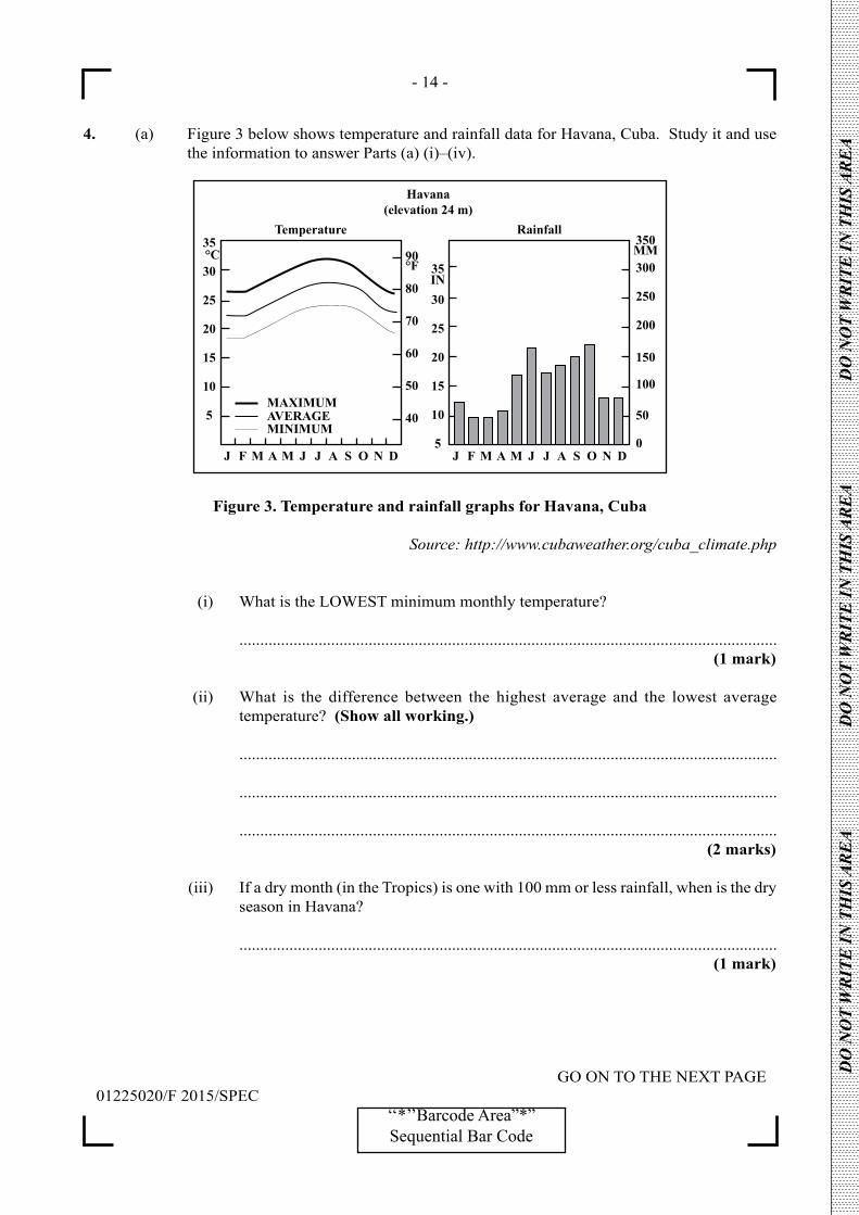
- 14 -
GO ON TO THE NEXT PAGE01225020/F 2015/SPEC
‘‘*’’Barcode Area”*”Sequential Bar Code
DO
NO
T W
RIT
E IN
TH
IS A
RE
A
DO
NO
T W
RIT
E IN
TH
IS A
RE
A
DO
NO
T W
RIT
E IN
TH
IS A
RE
A
4. (a) Figure 3 below shows temperature and rainfall data for Havana, Cuba. Study it and use the information to answer Parts (a) (i)–(iv).
Figure 3. Temperature and rainfall graphs for Havana, Cuba
Source: http://www.cubaweather.org/cuba_climate.php
(i) What is the LOWEST minimum monthly temperature?
................................................................................................................................. (1 mark)
(ii) What is the difference between the highest average and the lowest average temperature? (Show all working.)
.................................................................................................................................
.................................................................................................................................
................................................................................................................................. (2 marks)
(iii) If a dry month (in the Tropics) is one with 100 mm or less rainfall, when is the dry season in Havana?
................................................................................................................................. (1 mark)

- 15 -
GO ON TO THE NEXT PAGE01225020/F 2015/SPEC
‘‘*’’Barcode Area”*”Sequential Bar Code
DO
NO
T W
RIT
E IN
TH
IS A
RE
A
DO
NO
T W
RIT
E IN
TH
IS A
RE
A
DO
NO
T W
RIT
E IN
TH
IS A
RE
A
(iv) What is the general relationship between the temperature and rainfall patterns?
.................................................................................................................................
.................................................................................................................................
................................................................................................................................. (1 mark)
(b) (i) Describe TWO ways in which some agricultural practices in the Caribbean have resulted in environmental degradation.
.................................................................................................................................
.................................................................................................................................
.................................................................................................................................
.................................................................................................................................
.................................................................................................................................
.................................................................................................................................
.................................................................................................................................
.................................................................................................................................
.................................................................................................................................
.................................................................................................................................
.................................................................................................................................
.................................................................................................................................
.................................................................................................................................
.................................................................................................................................
.................................................................................................................................
.................................................................................................................................
................................................................................................................................. (4 marks)

- 16 -
GO ON TO THE NEXT PAGE01225020/F 2015/SPEC
‘‘*’’Barcode Area”*”Sequential Bar Code
DO
NO
T W
RIT
E IN
TH
IS A
RE
A
DO
NO
T W
RIT
E IN
TH
IS A
RE
A
DO
NO
T W
RIT
E IN
TH
IS A
RE
A
(ii) StateFOURbenefitsofmangrovewetlandstoCaribbeancountries.
.................................................................................................................................
.................................................................................................................................
.................................................................................................................................
.................................................................................................................................
.................................................................................................................................
.................................................................................................................................
.................................................................................................................................
.................................................................................................................................
.................................................................................................................................
.................................................................................................................................
.................................................................................................................................
.................................................................................................................................
.................................................................................................................................
.................................................................................................................................
.................................................................................................................................
.................................................................................................................................
................................................................................................................................. (4 marks)
- 17 -
GO ON TO THE NEXT PAGE01225020/F 2015/SPEC
‘‘*’’Barcode Area”*”Sequential Bar Code
DO
NO
T W
RIT
E IN
TH
IS A
RE
A
DO
NO
T W
RIT
E IN
TH
IS A
RE
A
DO
NO
T W
RIT
E IN
TH
IS A
RE
A
(c) (i) Explain TWO ways in which the development of agriculture in the Caribbean is influencedbyclimate.
.................................................................................................................................
.................................................................................................................................
.................................................................................................................................
.................................................................................................................................
.................................................................................................................................
.................................................................................................................................
.................................................................................................................................
.................................................................................................................................
.................................................................................................................................
................................................................................................................................. (6 marks)

- 18 -
01225020/F 2015/SPEC‘‘*’’Barcode Area”*”Sequential Bar Code
DO
NO
T W
RIT
E IN
TH
IS A
RE
A
DO
NO
T W
RIT
E IN
TH
IS A
RE
A
DO
NO
T W
RIT
E IN
TH
IS A
RE
A
(ii) Explain TWO ways in which human activities can have a positive impact on tropical forest biomes in the Caribbean.
.................................................................................................................................
.................................................................................................................................
.................................................................................................................................
.................................................................................................................................
.................................................................................................................................
.................................................................................................................................
.................................................................................................................................
.................................................................................................................................
.................................................................................................................................
................................................................................................................................. (6 marks)
Total 25 marks
END OF TEST
IF YOU FINISH BEFORE TIME IS CALLED, CHECK YOUR WORK ON THIS TEST.

- 19 -
01225020/F 2015/SPEC‘‘*’’Barcode Area”*”Sequential Bar Code
DO
NO
T W
RIT
E IN
TH
IS A
RE
A
DO
NO
T W
RIT
E IN
TH
IS A
RE
A
DO
NO
T W
RIT
E IN
TH
IS A
RE
A
EXTRA SPACE
If you use this extra page, you MUST write the question number clearly in the box provided.
Question No.
...........................................................................................................................................................................
...........................................................................................................................................................................
...........................................................................................................................................................................
...........................................................................................................................................................................
...........................................................................................................................................................................
...........................................................................................................................................................................
...........................................................................................................................................................................
...........................................................................................................................................................................
...........................................................................................................................................................................
...........................................................................................................................................................................
...........................................................................................................................................................................
...........................................................................................................................................................................
...........................................................................................................................................................................
...........................................................................................................................................................................
...........................................................................................................................................................................
...........................................................................................................................................................................
...........................................................................................................................................................................
...........................................................................................................................................................................
...........................................................................................................................................................................
...........................................................................................................................................................................
...........................................................................................................................................................................
- 20 -
01225020/F 2015/SPEC‘‘*’’Barcode Area”*”Sequential Bar Code
DO
NO
T W
RIT
E IN
TH
IS A
RE
A
DO
NO
T W
RIT
E IN
TH
IS A
RE
A
DO
NO
T W
RIT
E IN
TH
IS A
RE
A

- 21 -
01225020/F 2015/SPEC‘‘*’’Barcode Area”*”Sequential Bar Code
DO
NO
T W
RIT
E IN
TH
IS A
RE
A
DO
NO
T W
RIT
E IN
TH
IS A
RE
A
DO
NO
T W
RIT
E IN
TH
IS A
RE
A
EXTRA SPACE
If you use this extra page, you MUST write the question number clearly in the box provided.
Question No.
...........................................................................................................................................................................
...........................................................................................................................................................................
...........................................................................................................................................................................
...........................................................................................................................................................................
...........................................................................................................................................................................
...........................................................................................................................................................................
...........................................................................................................................................................................
...........................................................................................................................................................................
...........................................................................................................................................................................
...........................................................................................................................................................................
...........................................................................................................................................................................
...........................................................................................................................................................................
...........................................................................................................................................................................
...........................................................................................................................................................................
...........................................................................................................................................................................
...........................................................................................................................................................................
...........................................................................................................................................................................
...........................................................................................................................................................................
...........................................................................................................................................................................
...........................................................................................................................................................................
...........................................................................................................................................................................
- 22 -
01225020/F 2015/SPEC‘‘*’’Barcode Area”*”Sequential Bar Code
DO
NO
T W
RIT
E IN
TH
IS A
RE
A
DO
NO
T W
RIT
E IN
TH
IS A
RE
A
DO
NO
T W
RIT
E IN
TH
IS A
RE
A

DO NOT
WRIT
E O
NTH
IS P
AGE

CANDIDATE’S RECEIPT
INSTRUCTIONS TO CANDIDATE:
1. Fill in all the information requested clearly in capital letters.
TEST CODE:
SUBJECT:
PROFICIENCY:
REGISTRATION NUMBER:
FULL NAME: ________________________________________________________________ (BLOCK LETTERS)
Signature: ____________________________________________________________________
Date: ________________________________________________________________________
2. Ensure that this slip is detached by the Supervisor or Invigilator and given to you when you hand in this booklet.
3. Keep it in a safe place until you have received your results.
INSTRUCTION TO SUPERVISOR/INVIGILATOR:
Sign the declaration below, detach this slip and hand it to the candidate as his/her receipt for this booklet collected by you.
I hereby acknowledge receipt of the candidate’s booklet for the examination stated above.
Signature: _____________________________ Supervisor/Invigilator
Date: _________________________________
0 1 2 2 5 0 2 0
GEOGRAPHY – Paper 02
GENERAL

01207020/KMS/SPEC 2015
C A R I B B E A N E X A M I N A T I O N S C O U N C I L
CARIBBEAN SECONDARY EDUCATION CERTIFICATE®
EXAMINATION
GEOGRAPHY
SPECIMEN PAPER
PAPER 02 – GENERAL PROFICIENCY
KEY AND MARK SCHEME
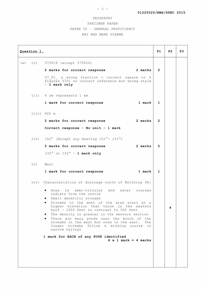
01225020/KMS/SPEC 2015
GEOGRAPHY
SPECIMEN PAPER
PAPER 02 – GENERAL PROFICIENCY
KEY AND MARK SCHEME
- 2 -
Question 1. P1 P2 P3
(a)
(i) 375019 (accept 375020)
2 marks for correct response 2 marks
37_01_ a wrong fraction = correct square or 4
figures 3701 or correct reference but wrong style
- 1 mark only
(ii) 4 cm represents 1 km
1 mark for correct response 1 mark
(iii) 600 m
2 marks for correct response 2 marks
Correct response - No unit - 1 mark
(iv) 152° (Accept any bearing 151°- 153°)
2 marks for correct response 2 marks
150° or 154° - 1 mark only
(v) West
1 mark for correct response 1 mark
(vi) Characteristics of drainage north of Northing 96:
Area is semi-circular and water courses
radiate from the centre
Small dendritic streams
Streams to the west of the area start at a
higher elevation than those in the eastern
half – 1500 feet in contrast to 500 feet
The density is greater in the western section
There are many ponds near the mouth of the
streams in the west but none in the east. The
longer streams follow a winding course in
narrow valleys
1 mark for EACH of any FOUR identified
4 x 1 mark = 4 marks
2
1
2
2
1
4
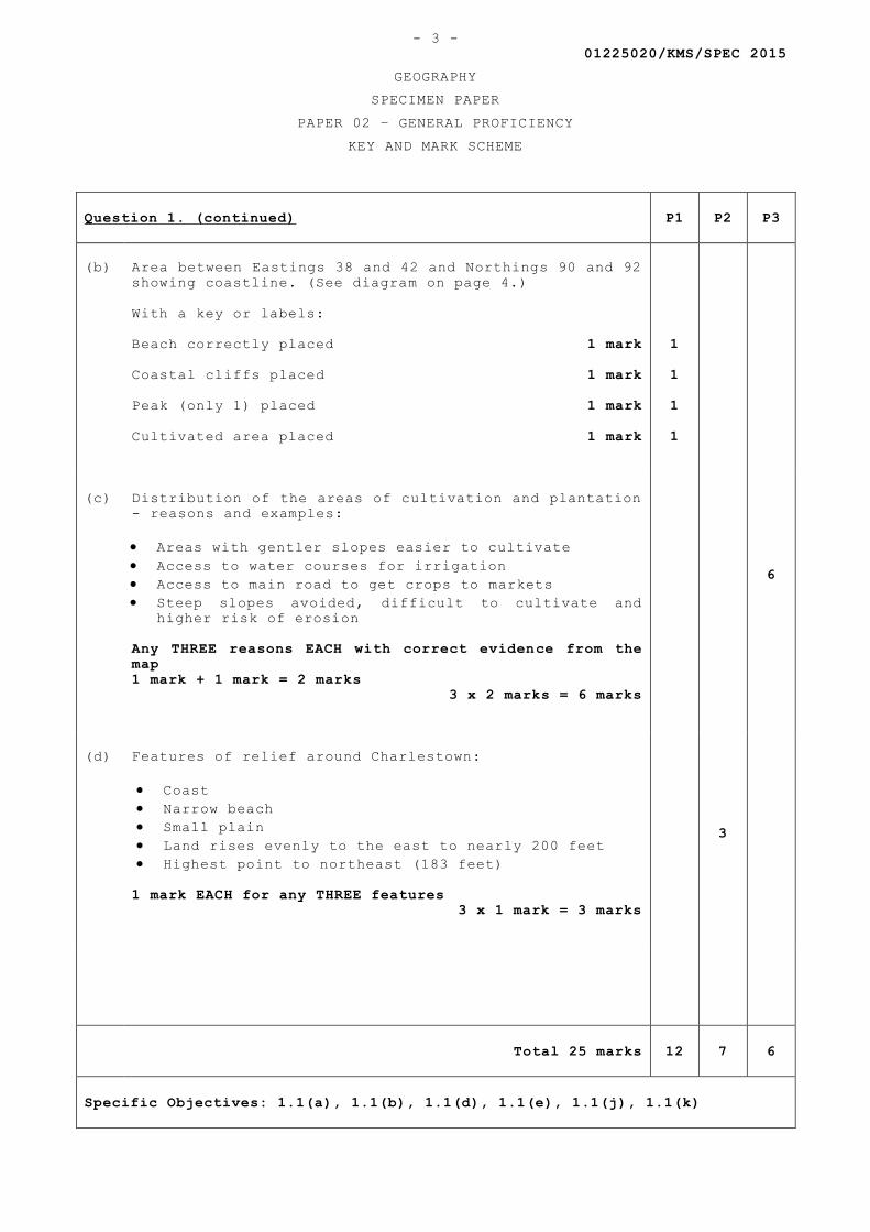
01225020/KMS/SPEC 2015
GEOGRAPHY
SPECIMEN PAPER
PAPER 02 – GENERAL PROFICIENCY
KEY AND MARK SCHEME
- 3 -
Question 1. (continued) P1 P2 P3
(b)
Area between Eastings 38 and 42 and Northings 90 and 92
showing coastline. (See diagram on page 4.)
With a key or labels:
Beach correctly placed 1 mark
Coastal cliffs placed 1 mark
Peak (only 1) placed 1 mark
Cultivated area placed 1 mark
1
1
1
1
(c)
Distribution of the areas of cultivation and plantation
- reasons and examples:
Areas with gentler slopes easier to cultivate
Access to water courses for irrigation
Access to main road to get crops to markets
Steep slopes avoided, difficult to cultivate and
higher risk of erosion
Any THREE reasons EACH with correct evidence from the
map
1 mark + 1 mark = 2 marks
3 x 2 marks = 6 marks
6
(d)
Features of relief around Charlestown:
Coast
Narrow beach
Small plain
Land rises evenly to the east to nearly 200 feet
Highest point to northeast (183 feet)
1 mark EACH for any THREE features
3 x 1 mark = 3 marks
3
Total 25 marks 12 7 6
Specific Objectives: 1.1(a), 1.1(b), 1.1(d), 1.1(e), 1.1(j), 1.1(k)
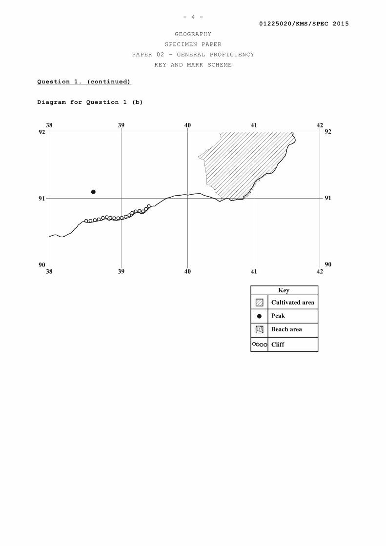
01225020/KMS/SPEC 2015
GEOGRAPHY
SPECIMEN PAPER
PAPER 02 – GENERAL PROFICIENCY
KEY AND MARK SCHEME
- 4 -
Question 1. (continued)
Diagram for Question 1 (b)
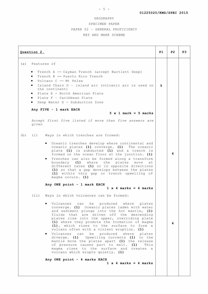
01225020/KMS/SPEC 2015
GEOGRAPHY
SPECIMEN PAPER
PAPER 02 – GENERAL PROFICIENCY
KEY AND MARK SCHEME
- 5 -
Question 2. P1 P2 P3
(a)
Features of
Trench A Cayman Trench (accept Bartlett Deep)
Trench B Puerto Rico Trench
Volcano C Mt Pelee
Island Chain D – island arc (volcanic arc is used on
the continent)
Plate E - North American Plate
Plate F – Caribbean Plate
Deep Water G - Subduction Zone
Any FIVE - 1 mark EACH
5 x 1 mark = 5 marks
Accept first five listed if more than five answers are
given
5
(b)
(i) Ways in which trenches are formed:
Oceanic trenches develop where continental and
oceanic plates (1) converge. (1) The oceanic
plate (1) is subducted (1) and a trench is
formed on the ocean floor at the junction. (1)
Trenches can also be formed along a transform
boundary (1) where the plates move at
different rates (1) or in opposite directions
(1) so that a gap develops between the plates
(1) within this gap or trench upwelling of
magma occurs. (1)
Any ONE point - 1 mark EACH
1 x 4 marks = 4 marks
(ii) Ways in which volcanoes can be formed:
Volcanoes can be produced where plates
converge. (1) Oceanic plates laden with water
and sediment plunge into the hot mantle, (1)
fluids that are driven off the descending
plates rise into the upper, overriding plate
(1) where they promote the formation of magma
(1), which rises to the surface to form a
volcano often with a violent eruption. (1)
Volcanoes can be produced where plates
diverge. (1) Upwelling currents (1) in the
mantle move the plates apart (1) the release
of pressure causes part to melt. (1) This
magma rises to the surface and creates a
volcano which erupts quietly. (1)
Any ONE point - 4 marks EACH
1 x 4 marks = 4 marks
4
4
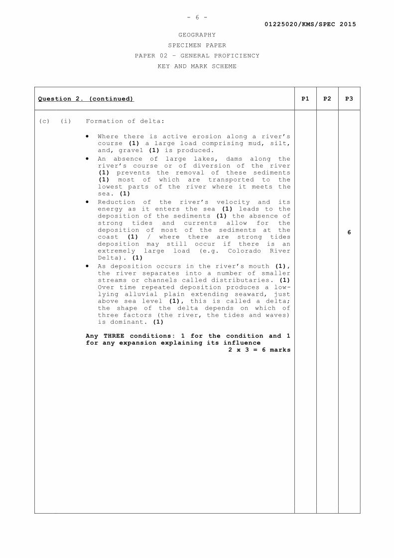
01225020/KMS/SPEC 2015
GEOGRAPHY
SPECIMEN PAPER
PAPER 02 – GENERAL PROFICIENCY
KEY AND MARK SCHEME
- 6 -
Question 2. (continued) P1 P2 P3
(c)
(i) Formation of delta:
Where there is active erosion along a river’s
course (1) a large load comprising mud, silt,
and, gravel (1) is produced.
An absence of large lakes, dams along the
river’s course or of diversion of the river
(1) prevents the removal of these sediments
(1) most of which are transported to the
lowest parts of the river where it meets the
sea. (1)
Reduction of the river’s velocity and its
energy as it enters the sea (1) leads to the
deposition of the sediments (1) the absence of
strong tides and currents allow for the
deposition of most of the sediments at the
coast (1) / where there are strong tides
deposition may still occur if there is an
extremely large load (e.g. Colorado River
Delta). (1)
As deposition occurs in the river’s mouth (1),
the river separates into a number of smaller
streams or channels called distributaries. (1)
Over time repeated deposition produces a low-
lying alluvial plain extending seaward, just
above sea level (1), this is called a delta;
the shape of the delta depends on which of
three factors (the river, the tides and waves)
is dominant. (1)
Any THREE conditions: 1 for the condition and 1
for any expansion explaining its influence
2 x 3 = 6 marks
6
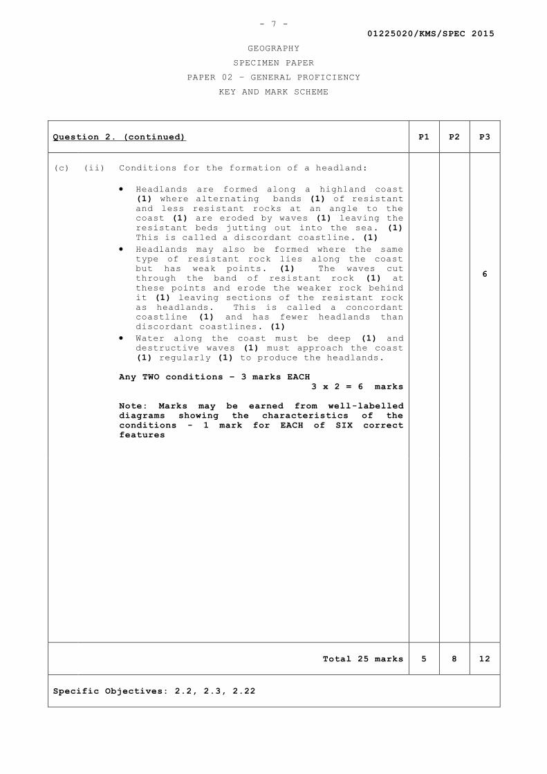
01225020/KMS/SPEC 2015
GEOGRAPHY
SPECIMEN PAPER
PAPER 02 – GENERAL PROFICIENCY
KEY AND MARK SCHEME
- 7 -
Question 2. (continued) P1 P2 P3
(c)
(ii) Conditions for the formation of a headland:
Headlands are formed along a highland coast
(1) where alternating bands (1) of resistant
and less resistant rocks at an angle to the
coast (1) are eroded by waves (1) leaving the
resistant beds jutting out into the sea. (1)
This is called a discordant coastline. (1)
Headlands may also be formed where the same
type of resistant rock lies along the coast
but has weak points. (1) The waves cut
through the band of resistant rock (1) at
these points and erode the weaker rock behind
it (1) leaving sections of the resistant rock
as headlands. This is called a concordant
coastline (1) and has fewer headlands than
discordant coastlines. (1)
Water along the coast must be deep (1) and
destructive waves (1) must approach the coast
(1) regularly (1) to produce the headlands.
Any TWO conditions – 3 marks EACH
3 x 2 = 6 marks
Note: Marks may be earned from well-labelled
diagrams showing the characteristics of the
conditions - 1 mark for EACH of SIX correct
features
6
Total 25 marks 5 8 12
Specific Objectives: 2.2, 2.3, 2.22
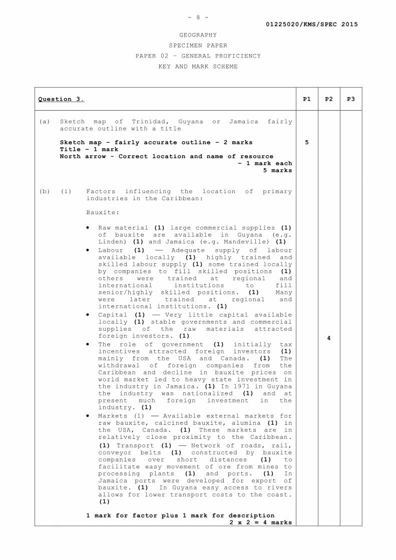
01225020/KMS/SPEC 2015
GEOGRAPHY
SPECIMEN PAPER
PAPER 02 – GENERAL PROFICIENCY
KEY AND MARK SCHEME
- 8 -
Question 3. P1 P2 P3
(a)
Sketch map of Trinidad, Guyana or Jamaica fairly
accurate outline with a title
Sketch map – fairly accurate outline – 2 marks
Title – 1 mark
North arrow - Correct location and name of resource
– 1 mark each
5 marks
5
(b)
(i) Factors influencing the location of primary
industries in the Caribbean:
Bauxite:
Raw material (1) large commercial supplies (1)
of bauxite are available in Guyana (e.g.
Linden) (1) and Jamaica (e.g. Mandeville) (1)
Labour (1) Adequate supply of labour
available locally (1) highly trained and
skilled labour supply (1) some trained locally
by companies to fill skilled positions (1)
others were trained at regional and
international institutions to fill
senior/highly skilled positions. (1) Many
were later trained at regional and
international institutions. (1)
Capital (1) Very little capital available
locally (1) stable governments and commercial
supplies of the raw materials attracted
foreign investors. (1)
The role of government (1) initially tax
incentives attracted foreign investors (1)
mainly from the USA and Canada. (1) The
withdrawal of foreign companies from the
Caribbean and decline in bauxite prices on
world market led to heavy state investment in
the industry in Jamaica. (1) In 1971 in Guyana
the industry was nationalized (1) and at
present much foreign investment in the
industry. (1)
Markets (1) Available external markets for
raw bauxite, calcined bauxite, alumina (1) in
the USA, Canada. (1) These markets are in
relatively close proximity to the Caribbean.
(1) Transport (1) Network of roads, rail,
conveyor belts (1) constructed by bauxite
companies over short distances (1) to
facilitate easy movement of ore from mines to
processing plants (1) and ports. (1) In
Jamaica ports were developed for export of
bauxite. (1) In Guyana easy access to rivers
allows for lower transport costs to the coast.
(1)
1 mark for factor plus 1 mark for description
2 x 2 = 4 marks
4
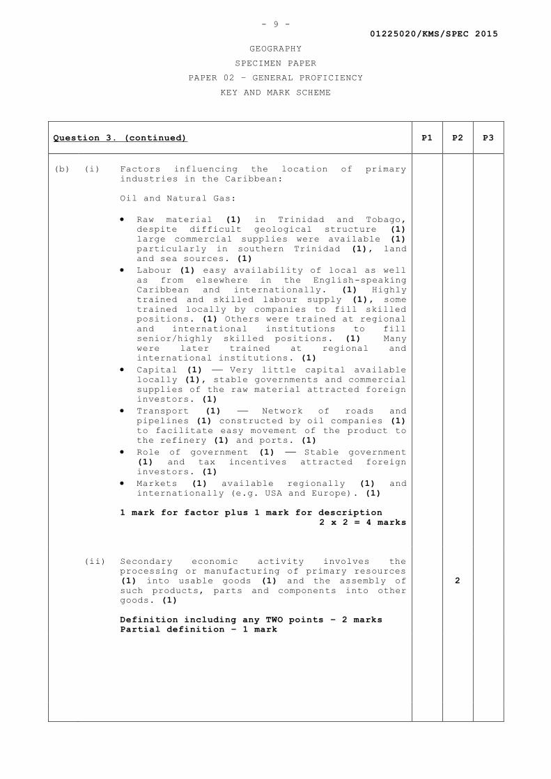
01225020/KMS/SPEC 2015
GEOGRAPHY
SPECIMEN PAPER
PAPER 02 – GENERAL PROFICIENCY
KEY AND MARK SCHEME
- 9 -
Question 3. (continued) P1 P2 P3
(b)
(i) Factors influencing the location of primary
industries in the Caribbean:
Oil and Natural Gas:
Raw material (1) in Trinidad and Tobago,
despite difficult geological structure (1)
large commercial supplies were available (1)
particularly in southern Trinidad (1), land
and sea sources. (1)
Labour (1) easy availability of local as well
as from elsewhere in the English-speaking
Caribbean and internationally. (1) Highly
trained and skilled labour supply (1), some
trained locally by companies to fill skilled
positions. (1) Others were trained at regional
and international institutions to fill
senior/highly skilled positions. (1) Many
were later trained at regional and
international institutions. (1)
Capital (1) Very little capital available
locally (1), stable governments and commercial
supplies of the raw material attracted foreign
investors. (1)
Transport (1) Network of roads and
pipelines (1) constructed by oil companies (1)
to facilitate easy movement of the product to
the refinery (1) and ports. (1)
Role of government (1) Stable government
(1) and tax incentives attracted foreign
investors. (1)
Markets (1) available regionally (1) and
internationally (e.g. USA and Europe). (1)
1 mark for factor plus 1 mark for description
2 x 2 = 4 marks
(ii) Secondary economic activity involves the
processing or manufacturing of primary resources
(1) into usable goods (1) and the assembly of
such products, parts and components into other
goods. (1)
Definition including any TWO points – 2 marks
Partial definition – 1 mark
2
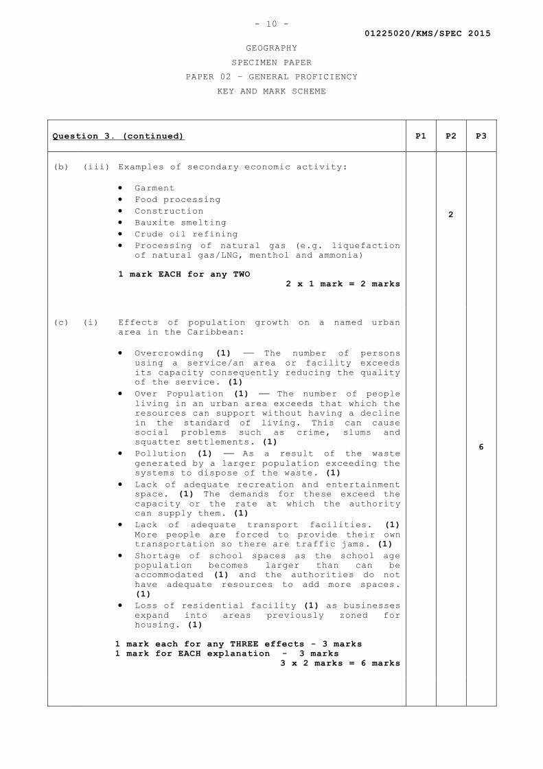
01225020/KMS/SPEC 2015
GEOGRAPHY
SPECIMEN PAPER
PAPER 02 – GENERAL PROFICIENCY
KEY AND MARK SCHEME
- 10 -
Question 3. (continued) P1 P2 P3
(b)
(iii) Examples of secondary economic activity:
Garment
Food processing
Construction
Bauxite smelting
Crude oil refining
Processing of natural gas (e.g. liquefaction
of natural gas/LNG, menthol and ammonia)
1 mark EACH for any TWO
2 x 1 mark = 2 marks
2
(c)
(i) Effects of population growth on a named urban
area in the Caribbean:
Overcrowding (1) The number of persons
using a service/an area or facility exceeds
its capacity consequently reducing the quality
of the service. (1)
Over Population (1) The number of people
living in an urban area exceeds that which the
resources can support without having a decline
in the standard of living. This can cause
social problems such as crime, slums and
squatter settlements. (1)
Pollution (1) As a result of the waste
generated by a larger population exceeding the
systems to dispose of the waste. (1)
Lack of adequate recreation and entertainment
space. (1) The demands for these exceed the
capacity or the rate at which the authority
can supply them. (1)
Lack of adequate transport facilities. (1)
More people are forced to provide their own
transportation so there are traffic jams. (1)
Shortage of school spaces as the school age
population becomes larger than can be
accommodated (1) and the authorities do not
have adequate resources to add more spaces.
(1)
Loss of residential facility (1) as businesses
expand into areas previously zoned for
housing. (1)
1 mark each for any THREE effects - 3 marks
1 mark for EACH explanation - 3 marks
3 x 2 marks = 6 marks
6
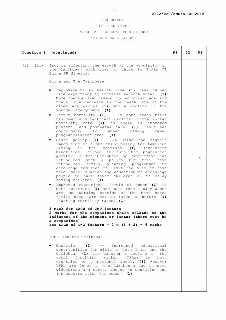
01225020/KMS/SPEC 2015
GEOGRAPHY
SPECIMEN PAPER
PAPER 02 – GENERAL PROFICIENCY
KEY AND MARK SCHEME
- 11 -
Question 3. (continued) P1 P2 P3
(c)
(ii) Factors affecting the growth of the population in
the Caribbean with that of those in India OR
China OR Nigeria:
China and The Caribbean
Improvements in health care (1) have caused
life expectancy to increase in both areas. (1)
More people are living to an older age and
there is a decrease in the death rate of the
older age groups (1) and a decline in the
younger age groups. (1)
Infant mortality (1) In both areas there
has been a significant decline in the infant
mortality rate (1) as there is improved
prenatal and postnatal care. (1) This has
contributed to women having fewer
pregnancies/children. (1)
State policy (1) In China the state’s
imposition of a one child policy for families
living on the mainland (1) (excluding
minorities) helped to curb the population
growth. In the Caribbean no government has
introduced such a policy but they have
introduced family planning programmes to
encourage families to limit the size or have
used moral suasion and education to encourage
people to have fewer children or to delay
having children. (1)
Improved educational levels of women (1) in
both countries (1) and as a result many women
are now working outside of the home hence
family sizes are not as large as before (1)
lowering fertility rates. (1)
1 mark for EACH of TWO factors
2 marks for the comparison which relates to the
influence of the element or factor (there must be
a comparison)
For EACH of TWO factors – 2 x (1 + 2) = 6 marks
India and the Caribbean:
Education (1) Increased educational
opportunities for girls in both India and the
Caribbean (1) are causing a decline in the
total fertility ratios (TFRs) in both
countries on a national level. (1) However
TFRs are lower in the Caribbean due to more
widespread and easier access to education and
job opportunities for women. (1)
6
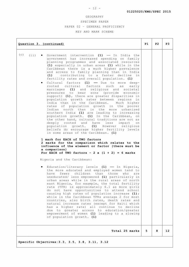
01225020/KMS/SPEC 2015
GEOGRAPHY
SPECIMEN PAPER
PAPER 02 – GENERAL PROFICIENCY
KEY AND MARK SCHEME
- 12 -
Question 3. (continued) P1 P2 P3
(c)
(ii) Government intervention (1) In India the
government has increased spending on family
planning programmes and associated resources
(1) especially in urban areas (1) while in the
Caribbean there is a much higher prevalence
and access to family planning than in India
(1) contributing to a faster decline in
fertility rates and overall population. (1)
Cultural factors (1) Due to more deep-
rooted cultural factors such as early
marriages (1) and religious and societal
pressures to bear sons (provide economic
support) (1), there are greater disparities in
population growth rates between regions in
India than in the Caribbean. Much higher
rates of population growth in the poorer
Indian north than in the more urbanized
southern India (1) are leading to increasing
population growth. (1) In the Caribbean, on
the other hand, cultural traditions are not as
deeply rooted and have less impact on
population growth. (1) However religious
beliefs do encourage higher fertility levels
in some areas of the Caribbean. (1)
1 mark for EACH of TWO factors
2 marks for the comparison which relates to the
influence of the element or factor (there must be
a comparison)
For EACH of TWO factors – 2 x (1 + 2) = 6 marks
Nigeria and the Caribbean:
Education/literacy levels (1) In Nigeria,
the more educated and employed women tend to
have fewer children than those who are
uneducated/ less empowered (1) particularly in
urban areas while in the rural areas of north
east Nigeria, for example, the total fertility
rate (TFR) is approximately 6.1 as more girls
do not have opportunities to attend school
causing high rates of population increase (1);
while in the Caribbean TFRs average 2 for most
countries, also birth rates, death rates and
natural increase rates (except for Haiti which
has a higher rate) all continue to decline
due to greater access to education/greater
empowerment of women (1) leading to a slowing
of population growth. (1)
Total 25 marks 5 8 12
Specific Objectives:3.3, 3.5, 3.8, 3.11, 3.12
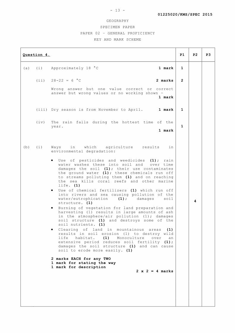
01225020/KMS/SPEC 2015
GEOGRAPHY
SPECIMEN PAPER
PAPER 02 – GENERAL PROFICIENCY
KEY AND MARK SCHEME
- 13 -
Question 4. P1 P2 P3
(a)
(i) Approximately 18 °C 1 mark
(ii) 28-22 = 6 °C 2 marks
Wrong answer but one value correct or correct
answer but wrong values or no working shown –
1 mark
(iii) Dry season is from November to April. 1 mark
(iv) The rain falls during the hottest time of the
year.
1 mark
1
2
1
1
(b)
(i) Ways in which agriculture results in
environmental degradation:
Use of pesticides and weedicides (1); rain
water washes these into soil and over time
damages the soil (1); their use contaminates
the ground water (1); these chemicals run off
to streams polluting them (1) and on reaching
the sea kills coral reefs and other marine
life. (1)
Use of chemical fertilizers (1) which run off
into rivers and sea causing pollution of the
water/eutrophication (1); damages soil
structure. (1)
Burning of vegetation for land preparation and
harvesting (1) results in large amounts of ash
in the atmosphere/air pollution (1); damages
soil structure (1) and destroys some of the
soil nutrients. (1)
Clearing of land in mountainous areas (1)
results in soil erosion (1) to destroy wild
life habitat. (1) Monoculture over an
extensive period reduces soil fertility (1);
damages the soil structure (1) and can cause
soil to erode more easily. (1)
2 marks EACH for any TWO
1 mark for stating the way
1 mark for description
2 x 2 = 4 marks
4
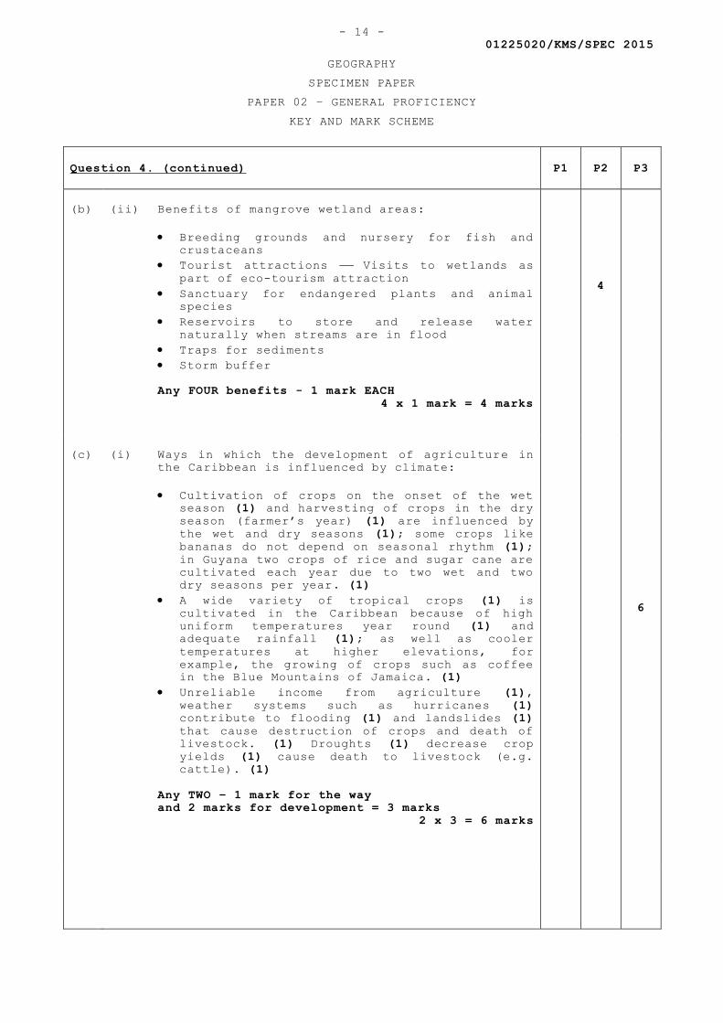
01225020/KMS/SPEC 2015
GEOGRAPHY
SPECIMEN PAPER
PAPER 02 – GENERAL PROFICIENCY
KEY AND MARK SCHEME
- 14 -
Question 4. (continued) P1 P2 P3
(b)
(ii) Benefits of mangrove wetland areas:
Breeding grounds and nursery for fish and
crustaceans
Tourist attractions Visits to wetlands as
part of eco-tourism attraction
Sanctuary for endangered plants and animal
species
Reservoirs to store and release water
naturally when streams are in flood
Traps for sediments
Storm buffer
Any FOUR benefits - 1 mark EACH
4 x 1 mark = 4 marks
4
(c)
(i) Ways in which the development of agriculture in
the Caribbean is influenced by climate:
Cultivation of crops on the onset of the wet
season (1) and harvesting of crops in the dry
season (farmer’s year) (1) are influenced by
the wet and dry seasons (1); some crops like
bananas do not depend on seasonal rhythm (1);
in Guyana two crops of rice and sugar cane are
cultivated each year due to two wet and two
dry seasons per year. (1)
A wide variety of tropical crops (1) is
cultivated in the Caribbean because of high
uniform temperatures year round (1) and
adequate rainfall (1); as well as cooler
temperatures at higher elevations, for
example, the growing of crops such as coffee
in the Blue Mountains of Jamaica. (1)
Unreliable income from agriculture (1),
weather systems such as hurricanes (1)
contribute to flooding (1) and landslides (1)
that cause destruction of crops and death of
livestock. (1) Droughts (1) decrease crop
yields (1) cause death to livestock (e.g.
cattle). (1)
Any TWO – 1 mark for the way
and 2 marks for development = 3 marks
2 x 3 = 6 marks
6
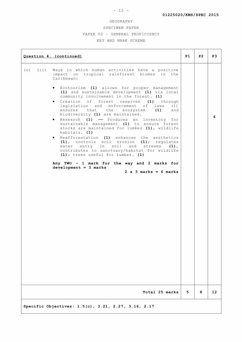
01225020/KMS/SPEC 2015
GEOGRAPHY
SPECIMEN PAPER
PAPER 02 – GENERAL PROFICIENCY
KEY AND MARK SCHEME
- 15 -
Question 4. (continued) P1 P2 P3
(c)
(ii) Ways in which human activities have a positive
impact on tropical rainforest biomes in the
Caribbean:
Ecotourism (1) allows for proper management
(1) and sustainable development (1) via local
community involvement in the forest. (1)
Creation of forest reserves (1) through
legislation and enforcement of laws (1)
ensures that the ecosystem (1) and
biodiversity (1) are maintained.
Research (1) Produces an inventory for
sustainable management (1) to ensure forest
stocks are maintained for lumber (1), wildlife
habitats. (1)
Reafforestation (1) enhances the aesthetics
(1), controls soil erosion (1); regulates
water entry in soil and streams (1),
contributes to sanctuary/habitat for wildlife
(1); trees useful for lumber. (1)
Any TWO – 1 mark for the way and 2 marks for
development = 3 marks
2 x 3 marks = 6 marks
6
Total 25 marks 5 8 12
Specific Objectives: 1.5(c), 3.21, 2.27, 3.16, 2.17

C A R I B B E A N E X A M I N A T I O N S C O U N C I L
CARIBBEAN SECONDARY EDUCATION CERTIFICATE®
EXAMINATION
FILL IN ALL THE INFORMATION REQUESTED CLEARLY IN CAPITAL LETTERS.
TEST CODE
SUBJECT
PROFICIENCY
REGISTRATION NUMBER
SCHOOL/CENTRE NUMBER
NAME OF SCHOOL/CENTRE
CANDIDATE’S FULL NAME (FIRST, MIDDLE, LAST)
DATE OF BIRTH D D M M Y Y Y Y
SIGNATURE __________________________________________________
‘‘*’’Barcode Area”*”Sequential Bar Code
‘‘*’’Barcode Area”*”Front Page Bar Code
‘‘*’’B
arco
de A
rea”
*”C
urre
nt B
ar C
ode
0 1 2 2 5 0 3 2
GEOGRAPHY – Paper 032
GENERAL

DO NOT
WRIT
E O
NTH
IS P
AGE
TEST CODE 01225032/SPECFORM TP 2015/SPEC MAY/JUNE 2015
C A R I B B E A N E X A M I N A T I O N S C O U N C I L
CARIBBEAN SECONDARY EDUCATION CERTIFICATE®
EXAMINATION
GEOGRAPHY
Paper 032 – General Proficiency
1 hour 45 minutes
SPECIMEN PAPER
READ THE FOLLOWING INSTRUCTIONS CAREFULLY.
1. This paper consists of SIX questions. Answer ALL questions.
2. Write your answers in the spaces provided in this booklet.
3. Do NOT write in the margins.
4. You may use a silent, non-programmable calculator to answer questions.
5. You may use geometrical instruments.
6. You are advised to take some time to read through the paper and plan your answers.
7. If you need to rewrite any answer and there is not enough space to do so on the original page, you must use the extra lined page(s) provided at the back of this booklet. Remember to draw a line through your original answer.
8. If you use the extra page(s), you MUST write the question number clearly in the box provided at the top of the extra page(s) and, where relevant, include the question part beside the answer.
DO NOT TURN THIS PAGE UNTIL YOU ARE TOLD TO DO SO.
Copyright © 2014 Caribbean Examinations CouncilAll rights reserved.
01225032/F 2015/SPEC‘‘*’’Barcode Area”*”Sequential Bar Code
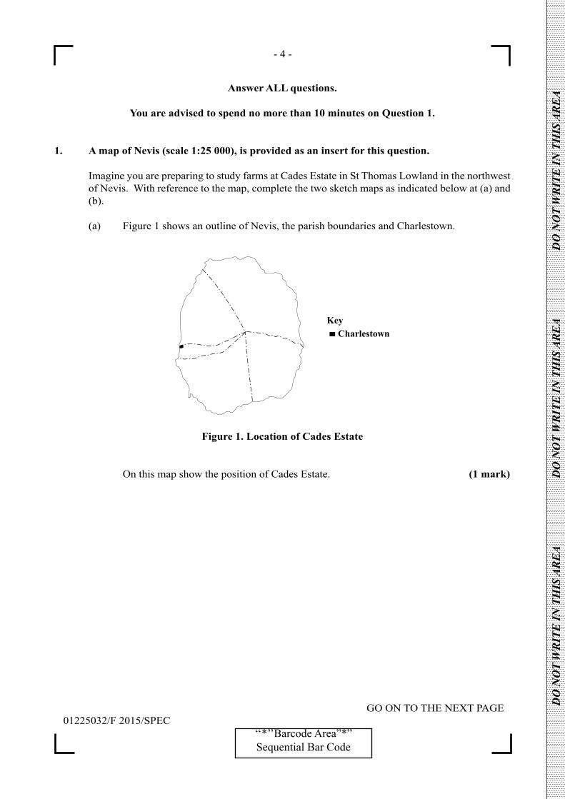
- 4 -
GO ON TO THE NEXT PAGE01225032/F 2015/SPEC
‘‘*’’Barcode Area”*”Sequential Bar Code
DO
NO
T W
RIT
E IN
TH
IS A
RE
A
DO
NO
T W
RIT
E IN
TH
IS A
RE
A
DO
NO
T W
RIT
E IN
TH
IS A
RE
A
Answer ALL questions.
You are advised to spend no more than 10 minutes on Question 1.
1. A map of Nevis (scale 1:25 000), is provided as an insert for this question.
Imagine you are preparing to study farms at Cades Estate in St Thomas Lowland in the northwest of Nevis. With reference to the map, complete the two sketch maps as indicated below at (a) and (b).
(a) Figure 1 shows an outline of Nevis, the parish boundaries and Charlestown.
KeyCharlestown
Figure 1. Location of Cades Estate
On this map show the position of Cades Estate. (1 mark)
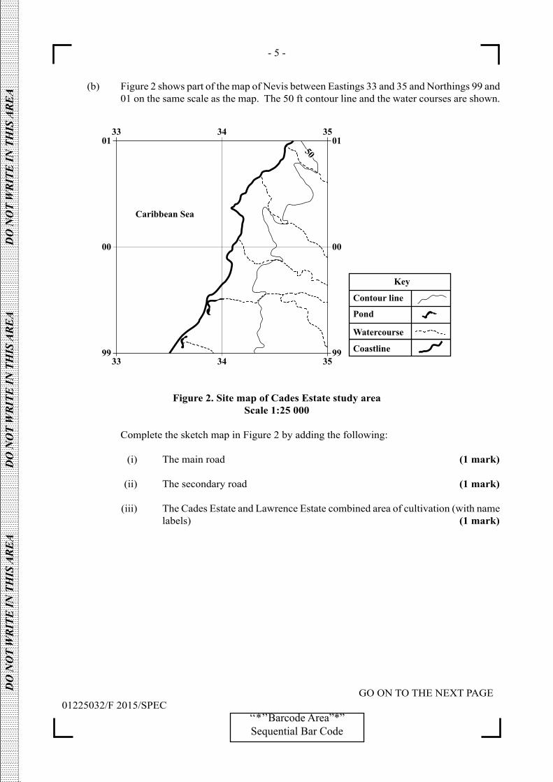
- 5 -
GO ON TO THE NEXT PAGE01225032/F 2015/SPEC
‘‘*’’Barcode Area”*”Sequential Bar Code
DO
NO
T W
RIT
E IN
TH
IS A
RE
A
DO
NO
T W
RIT
E IN
TH
IS A
RE
A
DO
NO
T W
RIT
E IN
TH
IS A
RE
A
(b) Figure 2 shows part of the map of Nevis between Eastings 33 and 35 and Northings 99 and 01 on the same scale as the map. The 50 ft contour line and the water courses are shown.
Figure 2. Site map of Cades Estate study areaScale 1:25 000
Complete the sketch map in Figure 2 by adding the following:
(i) The main road (1 mark)
(ii) The secondary road (1 mark)
(iii) The Cades Estate and Lawrence Estate combined area of cultivation (with name labels) (1 mark)

- 6 -
GO ON TO THE NEXT PAGE01225032/F 2015/SPEC
‘‘*’’Barcode Area”*”Sequential Bar Code
DO
NO
T W
RIT
E IN
TH
IS A
RE
A
DO
NO
T W
RIT
E IN
TH
IS A
RE
A
DO
NO
T W
RIT
E IN
TH
IS A
RE
A
2. You are to study the extent to which the characteristics of two small, commercial farms in the Cades Estate area in Nevis have been influenced by economic factors.
(a) Formulate a question or state a hypothesis to guide the collection of data in the field. This will be the ‘purpose’ or ‘aim’ of your research.
..............................................................................................................................................
..............................................................................................................................................
.............................................................................................................................................. (2 marks)
(b) Suggest a reason for studying the farms (the reason for your aim). This will form an introduction to your report.
..............................................................................................................................................
..............................................................................................................................................
..............................................................................................................................................
..............................................................................................................................................
.............................................................................................................................................. (2 marks)
3. (a) For the study in Question 2, list SIX items on which you would collect information from the farms.
..............................................................................................................................................
..............................................................................................................................................
..............................................................................................................................................
..............................................................................................................................................
..............................................................................................................................................
.............................................................................................................................................. (6 marks)
- 7 -
GO ON TO THE NEXT PAGE01225032/F 2015/SPEC
‘‘*’’Barcode Area”*”Sequential Bar Code
DO
NO
T W
RIT
E IN
TH
IS A
RE
A
DO
NO
T W
RIT
E IN
TH
IS A
RE
A
DO
NO
T W
RIT
E IN
TH
IS A
RE
A
(b) Describe how and when you would conduct the research and record the information in the spaces below.
How: .................................................................................................................................
.................................................................................................................................
.................................................................................................................................
.................................................................................................................................
................................................................................................................................. (3 marks)
When: .................................................................................................................................
.................................................................................................................................
................................................................................................................................. (2 marks)
(c) (i) Identify ONE problem (excluding the weather, illness and injury) that you are likely to encounter in conducting the research in (b) above.
.................................................................................................................................
.................................................................................................................................
................................................................................................................................. (1 mark)
(ii) State how you would overcome the problem that you identified in (c) (i) above. .................................................................................................................................
.................................................................................................................................
.................................................................................................................................
.................................................................................................................................
................................................................................................................................. ................................................................................................................................. (2 marks)
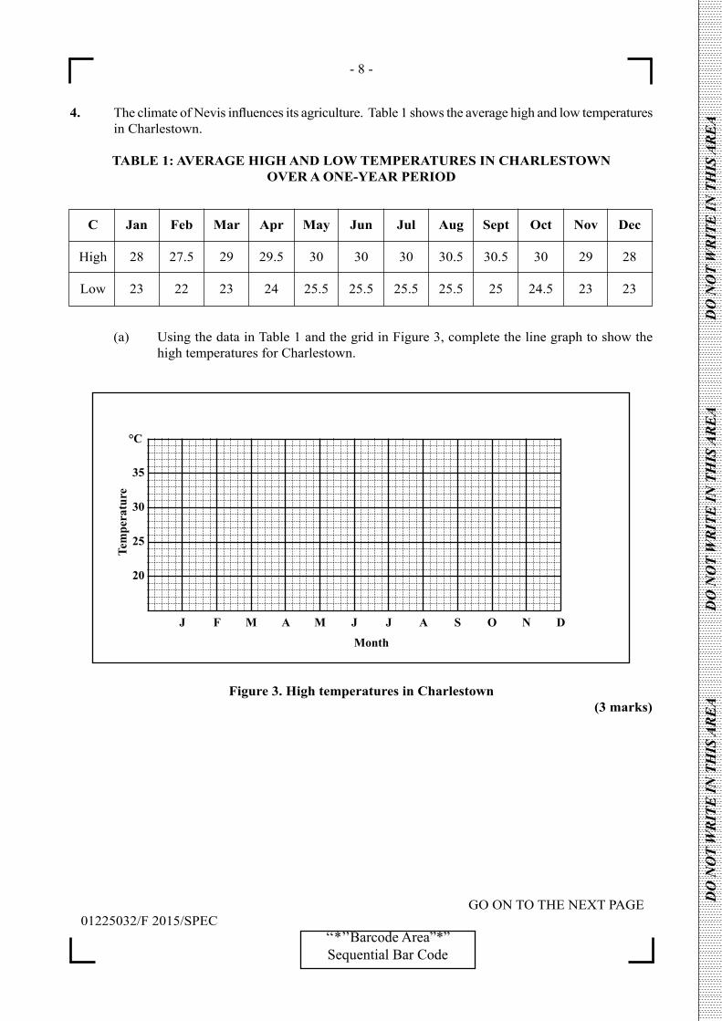
- 8 -
GO ON TO THE NEXT PAGE01225032/F 2015/SPEC
‘‘*’’Barcode Area”*”Sequential Bar Code
DO
NO
T W
RIT
E IN
TH
IS A
RE
A
DO
NO
T W
RIT
E IN
TH
IS A
RE
A
DO
NO
T W
RIT
E IN
TH
IS A
RE
A
4. The climate of Nevis influences its agriculture. Table 1 shows the average high and low temperatures in Charlestown.
TABLE 1: AVERAGE HIGH AND LOW TEMPERATURES IN CHARLESTOWN OVER A ONE-YEAR PERIOD
C Jan Feb Mar Apr May Jun Jul Aug Sept Oct Nov Dec
High 28 27.5 29 29.5 30 30 30 30.5 30.5 30 29 28
Low 23 22 23 24 25.5 25.5 25.5 25.5 25 24.5 23 23
(a) Using the data in Table 1 and the grid in Figure 3, complete the line graph to show the high temperatures for Charlestown.
Figure 3. High temperatures in Charlestown (3 marks)

- 9 -
GO ON TO THE NEXT PAGE01225032/F 2015/SPEC
‘‘*’’Barcode Area”*”Sequential Bar Code
DO
NO
T W
RIT
E IN
TH
IS A
RE
A
DO
NO
T W
RIT
E IN
TH
IS A
RE
A
DO
NO
T W
RIT
E IN
TH
IS A
RE
A
(b) Using the data in Table 1, describe how TWO characteristics of the temperature could make Charlestown suitable for farming.
..............................................................................................................................................
..............................................................................................................................................
..............................................................................................................................................
..............................................................................................................................................
..............................................................................................................................................
..............................................................................................................................................
..............................................................................................................................................
..............................................................................................................................................
..............................................................................................................................................
..............................................................................................................................................
..............................................................................................................................................
..............................................................................................................................................
..............................................................................................................................................
..............................................................................................................................................
..............................................................................................................................................
..............................................................................................................................................
..............................................................................................................................................
..............................................................................................................................................
..............................................................................................................................................
..............................................................................................................................................
..............................................................................................................................................
.............................................................................................................................................. (6 marks)
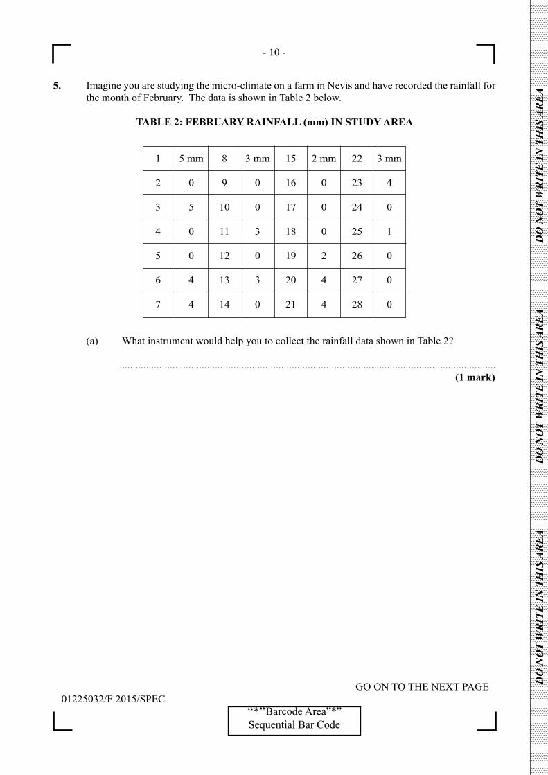
- 10 -
GO ON TO THE NEXT PAGE01225032/F 2015/SPEC
‘‘*’’Barcode Area”*”Sequential Bar Code
DO
NO
T W
RIT
E IN
TH
IS A
RE
A
DO
NO
T W
RIT
E IN
TH
IS A
RE
A
DO
NO
T W
RIT
E IN
TH
IS A
RE
A
5. Imagine you are studying the micro-climate on a farm in Nevis and have recorded the rainfall for the month of February. The data is shown in Table 2 below.
TABLE 2: FEBRUARY RAINFALL (mm) IN STUDY AREA
1 5 mm 8 3 mm 15 2 mm 22 3 mm
2 0 9 0 16 0 23 4
3 5 10 0 17 0 24 0
4 0 11 3 18 0 25 1
5 0 12 0 19 2 26 0
6 4 13 3 20 4 27 0
7 4 14 0 21 4 28 0
(a) What instrument would help you to collect the rainfall data shown in Table 2?
.............................................................................................................................................. (1 mark)
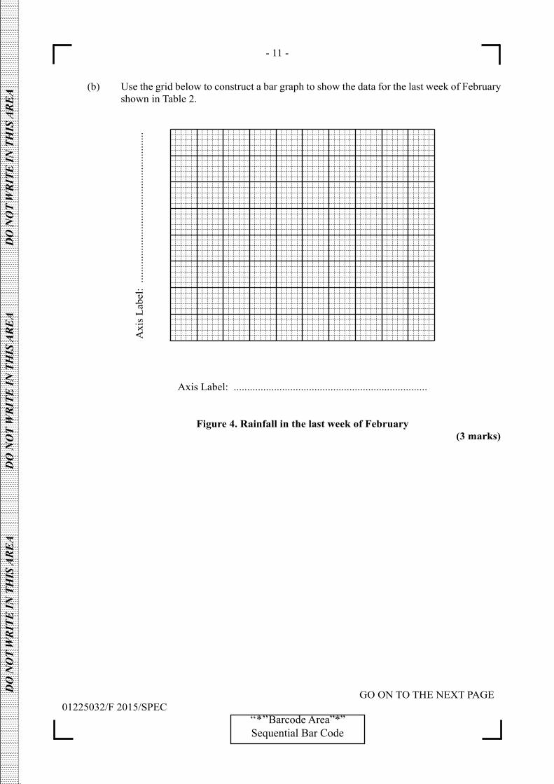
- 11 -
GO ON TO THE NEXT PAGE01225032/F 2015/SPEC
‘‘*’’Barcode Area”*”Sequential Bar Code
DO
NO
T W
RIT
E IN
TH
IS A
RE
A
DO
NO
T W
RIT
E IN
TH
IS A
RE
A
DO
NO
T W
RIT
E IN
TH
IS A
RE
A
(b) Use the grid below to construct a bar graph to show the data for the last week of February shown in Table 2.
Axis Label: ........................................................................
Figure 4. Rainfall in the last week of February (3 marks)
Axi
s La
bel:
.....
......
......
......
......
......
......
......
......
...
- 12 -
01225032/F 2015/SPEC‘‘*’’Barcode Area”*”Sequential Bar Code
DO
NO
T W
RIT
E IN
TH
IS A
RE
A
DO
NO
T W
RIT
E IN
TH
IS A
RE
A
DO
NO
T W
RIT
E IN
TH
IS A
RE
A
(c) The data in Table 2 is normal for February as it is the same as the average rainfall for Nevis. Explain TWO ways in which farming activities may be influenced by the rainfall.
..............................................................................................................................................
..............................................................................................................................................
..............................................................................................................................................
..............................................................................................................................................
..............................................................................................................................................
..............................................................................................................................................
..............................................................................................................................................
.............................................................................................................................................. (4 marks)
6. After completing the body of your report, you need to present the bibliography which lists the books that you used as references. Four of the five elements of a book required for a bibliography are listed below.
– City of publication– Name of publisher– Name of author– Year of publication
What is the fifth element?
.............................................................................................................................................................. (1 mark) Total 40 marks
END OF TEST
IF YOU FINISH BEFORE TIME IS CALLED, CHECK YOUR WORK ON THIS TEST.

- 13 -
01225032/F 2015/SPEC‘‘*’’Barcode Area”*”Sequential Bar Code
EXTRA SPACE
If you use this extra page, you MUST write the question number clearly in the box provided.
Question No.
...........................................................................................................................................................................
...........................................................................................................................................................................
...........................................................................................................................................................................
...........................................................................................................................................................................
...........................................................................................................................................................................
...........................................................................................................................................................................
...........................................................................................................................................................................
...........................................................................................................................................................................
...........................................................................................................................................................................
...........................................................................................................................................................................
...........................................................................................................................................................................
...........................................................................................................................................................................
...........................................................................................................................................................................
...........................................................................................................................................................................
...........................................................................................................................................................................
...........................................................................................................................................................................
...........................................................................................................................................................................
...........................................................................................................................................................................
...........................................................................................................................................................................
...........................................................................................................................................................................
...........................................................................................................................................................................
DO
NO
T W
RIT
E IN
TH
IS A
RE
A
DO
NO
T W
RIT
E IN
TH
IS A
RE
A
DO
NO
T W
RIT
E IN
TH
IS A
RE
A

- 14 -
01225032/F 2015/SPEC‘‘*’’Barcode Area”*”Sequential Bar Code
EXTRA SPACE
If you use this extra page, you MUST write the question number clearly in the box provided.
Question No.
...........................................................................................................................................................................
...........................................................................................................................................................................
...........................................................................................................................................................................
...........................................................................................................................................................................
...........................................................................................................................................................................
...........................................................................................................................................................................
...........................................................................................................................................................................
...........................................................................................................................................................................
...........................................................................................................................................................................
...........................................................................................................................................................................
...........................................................................................................................................................................
...........................................................................................................................................................................
...........................................................................................................................................................................
...........................................................................................................................................................................
...........................................................................................................................................................................
...........................................................................................................................................................................
...........................................................................................................................................................................
...........................................................................................................................................................................
...........................................................................................................................................................................
...........................................................................................................................................................................
...........................................................................................................................................................................
DO
NO
T W
RIT
E IN
TH
IS A
RE
A
DO
NO
T W
RIT
E IN
TH
IS A
RE
A
DO
NO
T W
RIT
E IN
TH
IS A
RE
A

DO NOT
WRIT
E O
NTH
IS P
AGE

CANDIDATE’S RECEIPT
INSTRUCTIONS TO CANDIDATE:
1. Fill in all the information requested clearly in capital letters.
TEST CODE:
SUBJECT:
PROFICIENCY:
REGISTRATION NUMBER:
FULL NAME: ________________________________________________________________ (BLOCK LETTERS)
Signature: ____________________________________________________________________
Date: ________________________________________________________________________
2. Ensure that this slip is detached by the Supervisor or Invigilator and given to you when you hand in this booklet.
3. Keep it in a safe place until you have received your results.
INSTRUCTION TO SUPERVISOR/INVIGILATOR:
Sign the declaration below, detach this slip and hand it to the candidate as his/her receipt for this booklet collected by you.
I hereby acknowledge receipt of the candidate’s booklet for the examination stated above.
Signature: _____________________________ Supervisor/Invigilator
Date: _________________________________
0 1 2 2 5 0 3 2
GEOGRAPHY – Paper 032
GENERAL
01207032/KMS/SPEC 2015
C A R I B B E A N E X A M I N A T I O N S C O U N C I L
CARIBBEAN SECONDARY EDUCATION CERTIFICATE®
EXAMINATION
GEOGRAPHY
SPECIMEN PAPER
PAPER 032 – GENERAL PROFICIENCY
KEY AND MARK SCHEME
01225032/KMS/SPEC 2015
GEOGRAPHY
SPECIMEN PAPER
PAPER 032 – GENERAL PROFICIENCY
KEY AND MARK SCHEME
- 2 -
Question
No. P1 P2 P3
1.
(a)
(b)
Figure 1
Outline map of Nevis with parish boundaries and
Charlestown. The location of Cades Estate clearly
shown. 1 mark
Figure 2
Site Map of Cades Estate Study Area with each of
the following:
(i) Main road
(ii) Secondary road
(iii) The Cades Estate and Lawrence Estate
combined area of cultivation (with name
labels)
1 mark for EACH correct response 3 marks
Specific Objective: 1.4 (b)
1
3
2.
(a)
(b)
Sample answers:
How have the characteristics of the two farms been
influenced by economic factors?
Are economic factors more important than other
factors in the two farming systems?
The two farms have been greatly influenced by
economic factors.
Any hypothesis or question that covers the
importance of the economic factors on the nature
of both farms 2 marks
Any which only mentions the factors or the nature
of the farms - E.g. Are economic factors
important?
1 mark
Specific Objective: 1.6.1
Any statement which can introduce the report:
For example: Some farmers are unable to make a
living only from farming. This study is to examine
how economic factors influence the farming in
Cades Estate. 2 marks
Clear overview with justification and topic
narrowed to the area of study – 2 marks
Introduction not clear or does not provide a focus
– 1 mark
Specific Objective: 1.6
2
2
01225032/KMS/SPEC 2015
GEOGRAPHY
SPECIMEN PAPER
PAPER 032 – GENERAL PROFICIENCY
KEY AND MARK SCHEME
- 3 -
Question
No. P1 P2 P3
3.
(a)
(b)
(c)
Any 6 items:
Date; Gender of farmer; Age of farmer; Area of
farm; Land Use(area cultivated and area in
pasture); Ownership – Land tenure; Labour (family
or hired); Crops (types, acreage); Livestock
(type, numbers); Marketing (direct to consumers
or to vendors); Is there any processing of
products? Is farming the only occupation? What
are the costs of production? Are there subsidies?
ANY other item which is relevant to the topic
1 mark for EACH RELEVANT item
6 x 1 mark = 6 marks
Specific Objective: 1.6
HOW – Prepare a data record sheet/questionnaire
(1); Make appointments with the farmers (1). Make
a sketch map (1). Take photographs (1).
1 mark for EACH relevant technique
3 x 1 mark = 3 marks
WHEN - On a week day during the day (1), by
appointment (1), avoiding Rainy Season if possible
(1) over two days (1).
Any TWO points – 1 mark EACH 1 x 2 = 2 marks
(i) EXAMPLE: Unwillingness of farmers to be
interviewed.
Any appropriate problem 1 mark
(ii) EXAMPLE. Seek the help of the Ministry of
Agriculture to be introduced to the
farmers.
Any appropriate solution for the problem
identified 2 marks
A weak solution - 1 mark
Specific Objective: 1.6
6
3
2
1
2
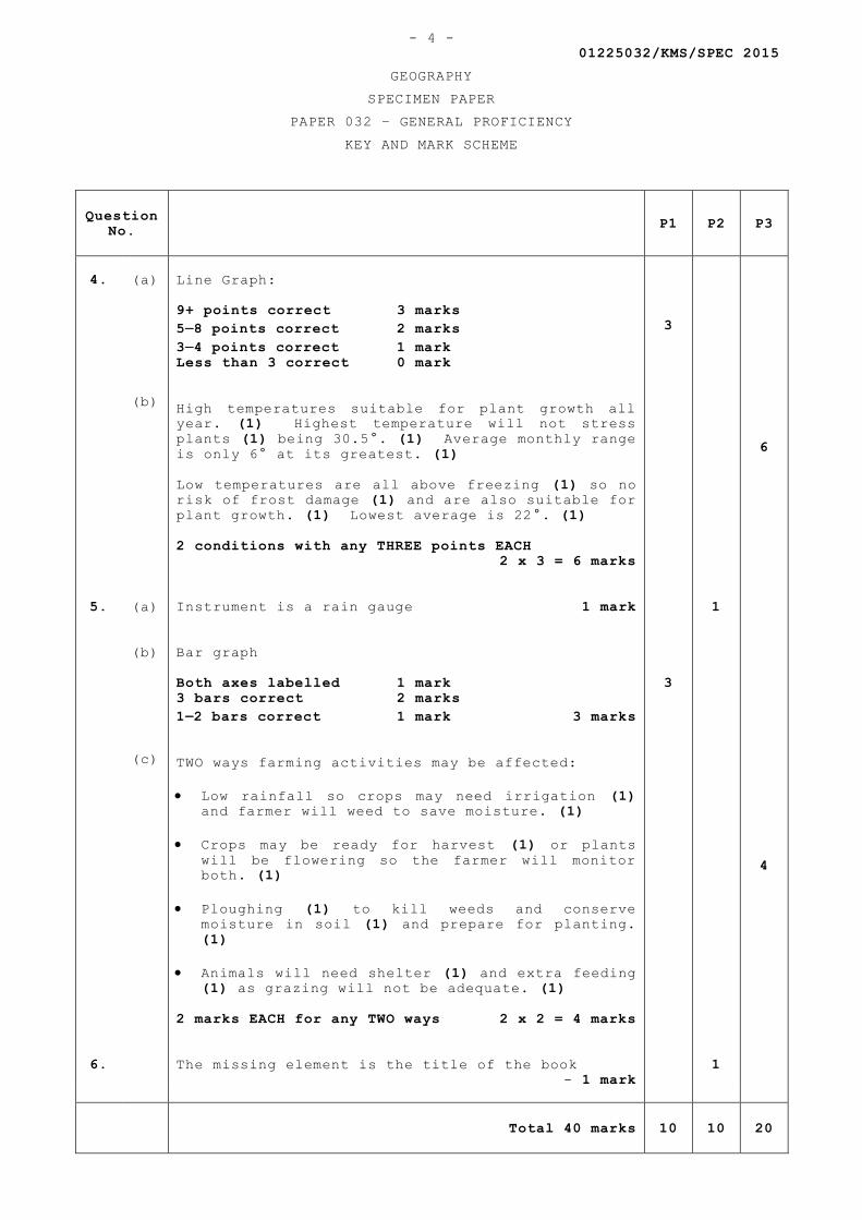
01225032/KMS/SPEC 2015
GEOGRAPHY
SPECIMEN PAPER
PAPER 032 – GENERAL PROFICIENCY
KEY AND MARK SCHEME
- 4 -
Question
No. P1 P2 P3
4.
(a)
(b)
Line Graph:
9+ points correct 3 marks
58 points correct 2 marks
34 points correct 1 mark
Less than 3 correct 0 mark
High temperatures suitable for plant growth all
year. (1) Highest temperature will not stress
plants (1) being 30.5°. (1) Average monthly range
is only 6° at its greatest. (1)
Low temperatures are all above freezing (1) so no
risk of frost damage (1) and are also suitable for
plant growth. (1) Lowest average is 22°. (1)
2 conditions with any THREE points EACH
2 x 3 = 6 marks
3
6
5.
(a)
(b)
(c)
Instrument is a rain gauge 1 mark
Bar graph
Both axes labelled 1 mark
3 bars correct 2 marks
12 bars correct 1 mark 3 marks
TWO ways farming activities may be affected:
Low rainfall so crops may need irrigation (1)
and farmer will weed to save moisture. (1)
Crops may be ready for harvest (1) or plants
will be flowering so the farmer will monitor
both. (1)
Ploughing (1) to kill weeds and conserve
moisture in soil (1) and prepare for planting.
(1)
Animals will need shelter (1) and extra feeding
(1) as grazing will not be adequate. (1)
2 marks EACH for any TWO ways 2 x 2 = 4 marks
3
1
4
6.
The missing element is the title of the book
- 1 mark
1
Total 40 marks 10 10 20

01225032/KMS/SPEC 2015
GEOGRAPHY
SPECIMEN PAPER
PAPER 032 – GENERAL PROFICIENCY
KEY AND MARK SCHEME
- 5 -


![Geography - Physics, Electronics and IT [CAPE & CSEC] · PDF fileFORMAT OF THE EXAMINATIONS ... Geography is concerned with spatial expression, ... Paper 02 (2 h our s 3 0 min u tes,](https://img.pdfslide.us/doc/110x75/5abd40847f8b9a7e418b594e/geography-physics-electronics-and-it-cape-csec-of-the-examinations-geography.jpg)