Embed Size (px)
Citation preview
IEB Copyright © 2014 PLEASE TURN OVER
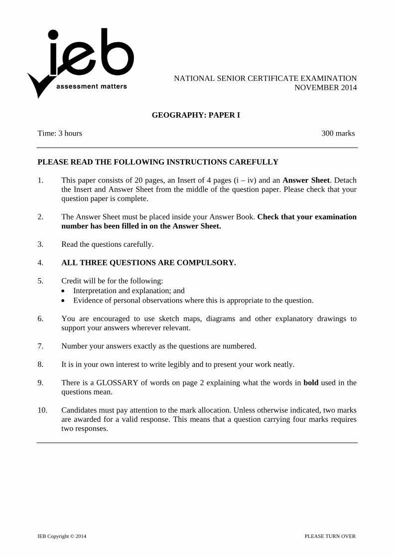
NATIONAL SENIOR CERTIFICATE EXAMINATION NOVEMBER 2014
GEOGRAPHY: PAPER I Time: 3 hours 300 marks PLEASE READ THE FOLLOWING INSTRUCTIONS CAREFULLY 1. This paper consists of 20 pages, an Insert of 4 pages (i – iv) and an Answer Sheet. Detach
the Insert and Answer Sheet from the middle of the question paper. Please check that your question paper is complete.
2. The Answer Sheet must be placed inside your Answer Book. Check that your examination
number has been filled in on the Answer Sheet. 3. Read the questions carefully. 4. ALL THREE QUESTIONS ARE COMPULSORY. 5. Credit will be for the following:
Interpretation and explanation; and Evidence of personal observations where this is appropriate to the question.
6. You are encouraged to use sketch maps, diagrams and other explanatory drawings to
support your answers wherever relevant. 7. Number your answers exactly as the questions are numbered. 8. It is in your own interest to write legibly and to present your work neatly. 9. There is a GLOSSARY of words on page 2 explaining what the words in bold used in the
questions mean. 10. Candidates must pay attention to the mark allocation. Unless otherwise indicated, two marks
are awarded for a valid response. This means that a question carrying four marks requires two responses.
NATIONAL SENIOR CERTIFICATE: GEOGRAPHY: PAPER I Page 2 of 20
IEB Copyright © 2014
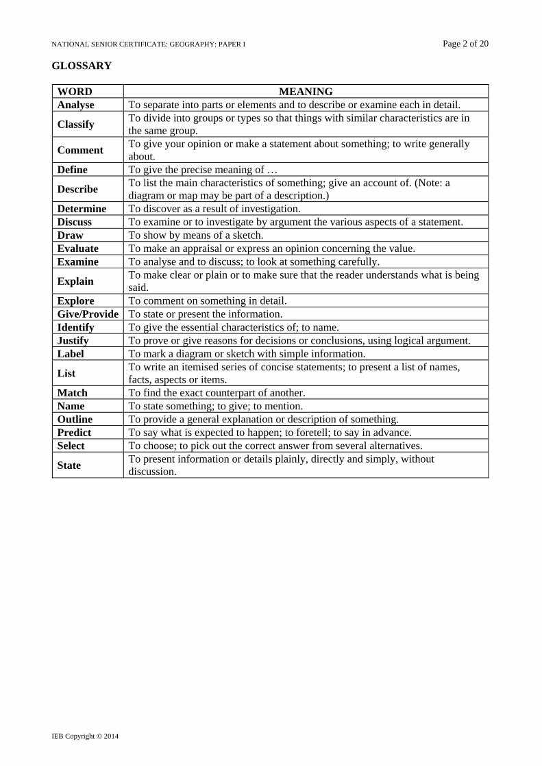
GLOSSARY
WORD MEANING Analyse To separate into parts or elements and to describe or examine each in detail.
Classify To divide into groups or types so that things with similar characteristics are in the same group.
Comment To give your opinion or make a statement about something; to write generally about.
Define To give the precise meaning of …
Describe To list the main characteristics of something; give an account of. (Note: a diagram or map may be part of a description.)
Determine To discover as a result of investigation. Discuss To examine or to investigate by argument the various aspects of a statement. Draw To show by means of a sketch. Evaluate To make an appraisal or express an opinion concerning the value. Examine To analyse and to discuss; to look at something carefully.
Explain To make clear or plain or to make sure that the reader understands what is being said.
Explore To comment on something in detail. Give/Provide To state or present the information. Identify To give the essential characteristics of; to name. Justify To prove or give reasons for decisions or conclusions, using logical argument. Label To mark a diagram or sketch with simple information.
List To write an itemised series of concise statements; to present a list of names, facts, aspects or items.
Match To find the exact counterpart of another. Name To state something; to give; to mention. Outline To provide a general explanation or description of something. Predict To say what is expected to happen; to foretell; to say in advance. Select To choose; to pick out the correct answer from several alternatives.
State To present information or details plainly, directly and simply, without discussion.
NATIONAL SENIOR CERTIFICATE: GEOGRAPHY: PAPER I Page 3 of 20
IEB Copyright © 2014 PLEASE TURN OVER
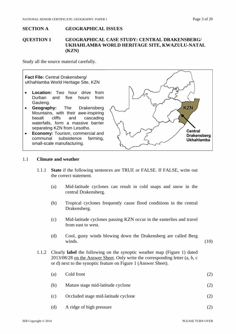
SECTION A GEOGRAPHICAL ISSUES QUESTION 1 GEOGRAPHICAL CASE STUDY: CENTRAL DRAKENSBERG/ UKHAHLAMBA WORLD HERITAGE SITE, KWAZULU-NATAL (KZN) Study all the source material carefully.
Fact File: Central Drakensberg/ uKhahlamba World Heritage Site, KZN Location: Two hour drive from
Durban and five hours from Gauteng.
Geography: The Drakensberg Mountains, with their awe-inspiring basalt cliffs and cascading waterfalls, form a massive barrier separating KZN from Lesotho.
Economy: Tourism, commercial and communal subsistence farming, small-scale manufacturing.
1.1 Climate and weather
1.1.1 State if the following sentences are TRUE or FALSE. If FALSE, write out
the correct statement.
(a) Mid-latitude cyclones can result in cold snaps and snow in the central Drakensberg.
(b) Tropical cyclones frequently cause flood conditions in the central
Drakensberg. (c) Mid-latitude cyclones passing KZN occur in the easterlies and travel
from east to west. (d) Cool, gusty winds blowing down the Drakensberg are called Berg
winds. (10) 1.1.2 Clearly label the following on the synoptic weather map (Figure 1) dated
2013/08/28 on the Answer Sheet. Only write the corresponding letter (a, b, c or d) next to the synoptic feature on Figure 1 (Answer Sheet).
(a) Cold front (2) (b) Mature stage mid-latitude cyclone (2) (c) Occluded stage mid-latitude cyclone (2) (d) A ridge of high pressure (2)
NATIONAL SENIOR CERTIFICATE: GEOGRAPHY: PAPER I Page 4 of 20
IEB Copyright © 2014
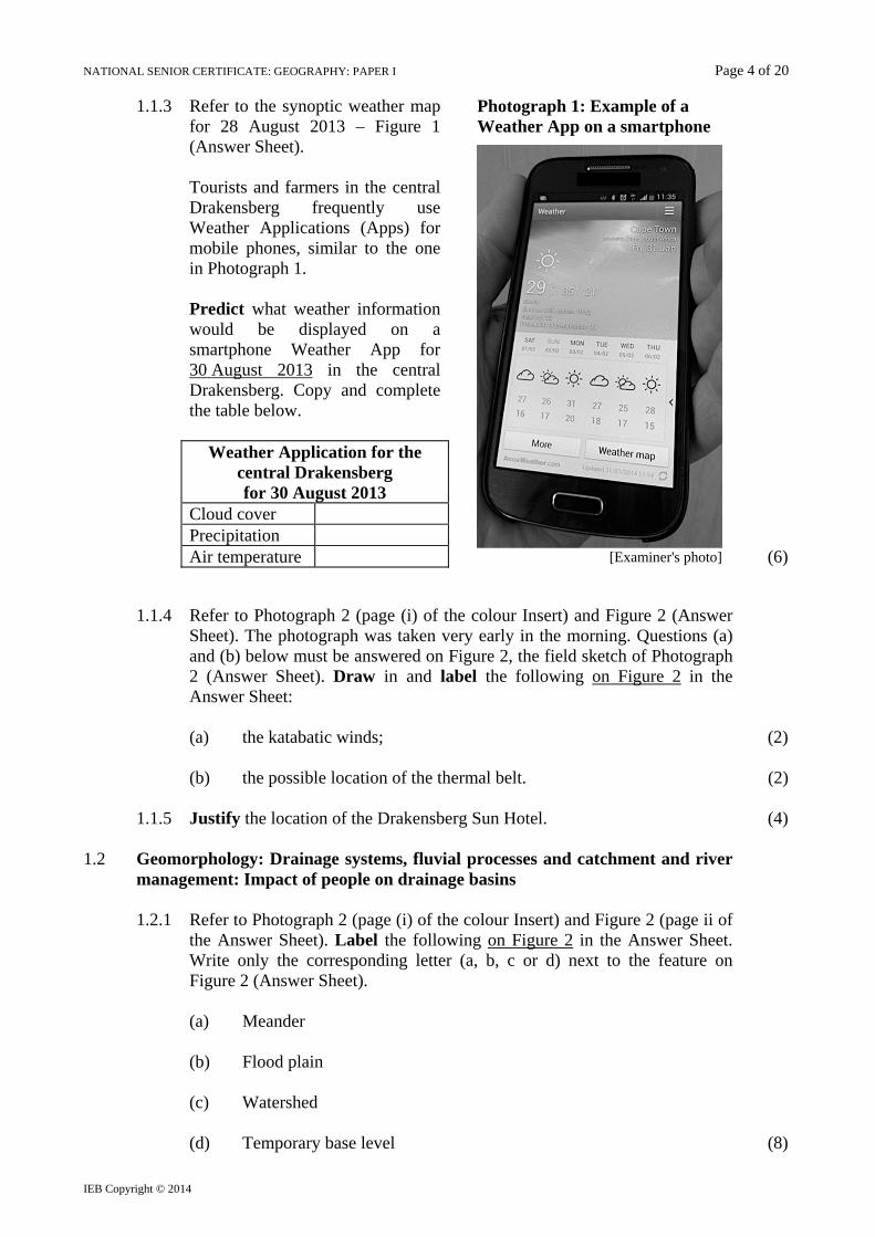
1.1.3 Refer to the synoptic weather map for 28 August 2013 – Figure 1 (Answer Sheet). Tourists and farmers in the central Drakensberg frequently use Weather Applications (Apps) for mobile phones, similar to the one in Photograph 1. Predict what weather information would be displayed on a smartphone Weather App for 30 August 2013 in the central Drakensberg. Copy and complete the table below.
Photograph 1: Example of a Weather App on a smartphone
[Examiner's photo]
Weather Application for the central Drakensberg for 30 August 2013
Cloud cover Precipitation Air temperature (6)
1.1.4 Refer to Photograph 2 (page (i) of the colour Insert) and Figure 2 (Answer Sheet). The photograph was taken very early in the morning. Questions (a) and (b) below must be answered on Figure 2, the field sketch of Photograph 2 (Answer Sheet). Draw in and label the following on Figure 2 in the Answer Sheet:
(a) the katabatic winds; (2)
(b) the possible location of the thermal belt. (2)
1.1.5 Justify the location of the Drakensberg Sun Hotel. (4)
1.2 Geomorphology: Drainage systems, fluvial processes and catchment and river
management: Impact of people on drainage basins
1.2.1 Refer to Photograph 2 (page (i) of the colour Insert) and Figure 2 (page ii of the Answer Sheet). Label the following on Figure 2 in the Answer Sheet. Write only the corresponding letter (a, b, c or d) next to the feature on Figure 2 (Answer Sheet).
(a) Meander
(b) Flood plain
(c) Watershed
(d) Temporary base level (8)
NATIONAL SENIOR CERTIFICATE: GEOGRAPHY: PAPER I Page 5 of 20
IEB Copyright © 2014 PLEASE TURN OVER
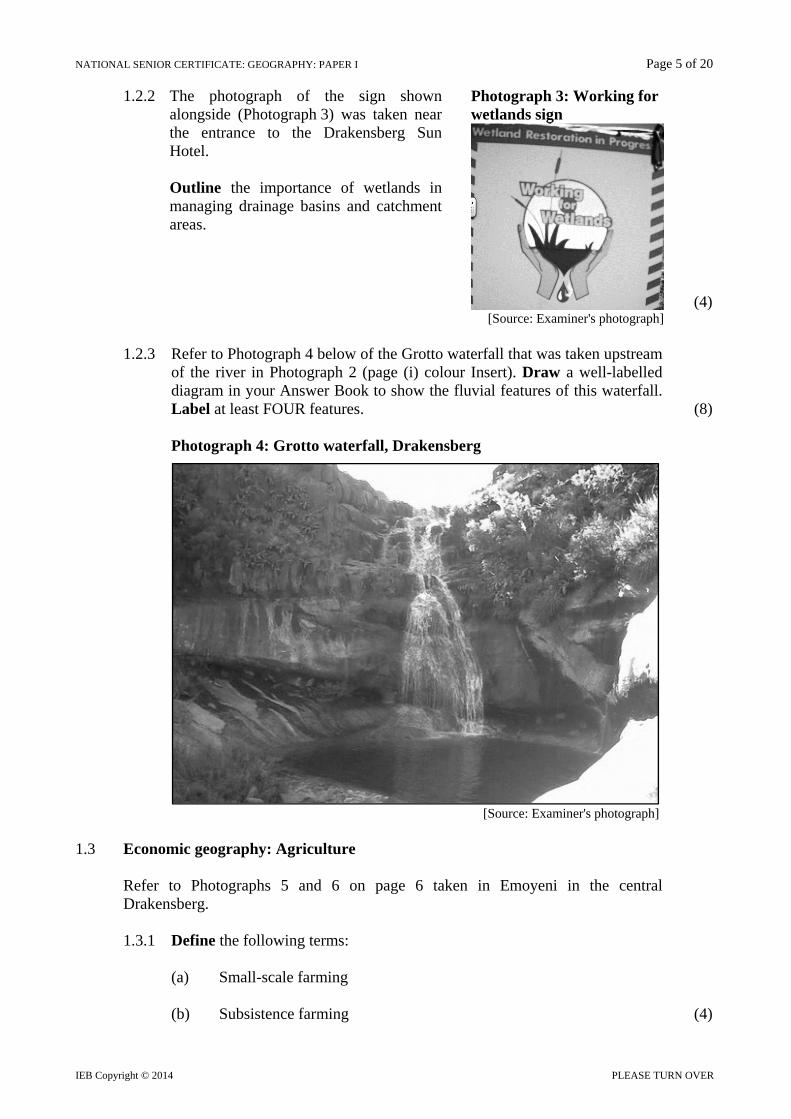
1.2.2 The photograph of the sign shown alongside (Photograph 3) was taken near the entrance to the Drakensberg Sun Hotel. Outline the importance of wetlands in managing drainage basins and catchment areas.
Photograph 3: Working for wetlands sign
(4)
[Source: Examiner's photograph]
1.2.3 Refer to Photograph 4 below of the Grotto waterfall that was taken upstream of the river in Photograph 2 (page (i) colour Insert). Draw a well-labelled diagram in your Answer Book to show the fluvial features of this waterfall. Label at least FOUR features. (8)
Photograph 4: Grotto waterfall, Drakensberg
[Source: Examiner's photograph]
1.3 Economic geography: Agriculture
Refer to Photographs 5 and 6 on page 6 taken in Emoyeni in the central Drakensberg.
1.3.1 Define the following terms:
(a) Small-scale farming
(b) Subsistence farming (4)
NATIONAL SENIOR CERTIFICATE: GEOGRAPHY: PAPER I Page 6 of 20
IEB Copyright © 2014
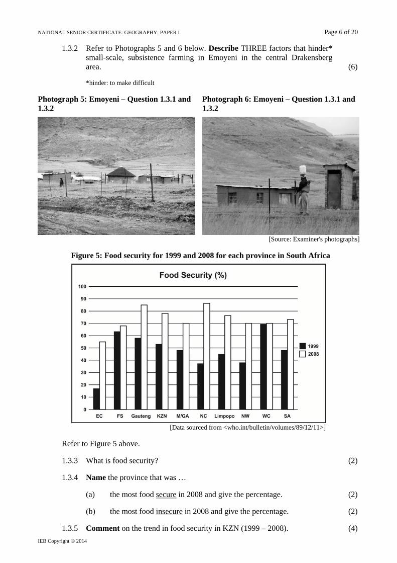
1.3.2 Refer to Photographs 5 and 6 below. Describe THREE factors that hinder* small-scale, subsistence farming in Emoyeni in the central Drakensberg area. (6)
*hinder: to make difficult
Photograph 5: Emoyeni – Question 1.3.1 and 1.3.2
Photograph 6: Emoyeni – Question 1.3.1 and 1.3.2
[Source: Examiner's photographs]
Figure 5: Food security for 1999 and 2008 for each province in South Africa
[Data sourced from <who.int/bulletin/volumes/89/12/11>]
Refer to Figure 5 above.
1.3.3 What is food security? (2)
1.3.4 Name the province that was …
(a) the most food secure in 2008 and give the percentage. (2)
(b) the most food insecure in 2008 and give the percentage. (2)
1.3.5 Comment on the trend in food security in KZN (1999 – 2008). (4)

NATIONAL SENIOR CERTIFICATE: GEOGRAPHY: PAPER I Page 7 of 20
IEB Copyright © 2014 PLEASE TURN OVER
1.4 Settlement Geography: Settlement classification, rural settlement issues Economic Geography: Strategies for industrial development
Refer to Photograph 7, a vertical aerial photograph of Emoyeni and the Bata shoe factory (page i of the colour Insert).
1.4.1 Classify the settlement at A (Photograph 7) in terms of …
(a) Pattern
(b) Function (4)
Fact File: Bata Shoe Factory
Bata Shoe Company is a family owned global footwear and fashion accessory company with its headquarters based in Switzerland.
The Bata Shoe organisation has sold more than 14 billion pairs of shoes and was awarded the Guinness World Record as the 'Largest Shoe Retailer and Manufacturer'.
The company is involved in many outreach programmes. One is to feed and to educate the children of its employees.
The Emoyeni Bata shoe factory in KZN can be defined as a labour-oriented industry.
The factory was originally located in the central Drakensberg area as part of the Apartheid Government's industrial development strategy.
[Sources: Wikipedia and local interviews/examiner's photograph]
1.4.2 Describe the location of the Bata shoe factory in terms of situation. (4)
1.4.3 Refer to the Fact File and explain the following terms:
(a) Retailer
(b) Manufacturer
(c) Labour-oriented industry
(d) Apartheid Government's industrial development strategy (8)
1.4.4 Refer to Photograph 8 (page ii colour Insert).
Mobile clinics are one way the local government is providing health services to people living in Emoyeni and thereby addressing a cause of rural depopulation.
Explore the possible effects of rural depopulation on the settlement of Emoyeni and discuss how tourism and the Bata Shoe factory can be used to address rapid rural-urban migration in the area. (12)
100 marks

NATIONAL SENIOR CERTIFICATE: GEOGRAPHY: PAPER I Page 8 of 20
IEB Copyright © 2014
SECTION B CLIMATE AND WEATHER AND GEOMORPHOLOGY QUESTION 2 2.1 Tropical cyclones
2.1.1 Select the correct underlined terms in each of the following sentences. Write down only the question number (a) to (d) and the correct term(s) in your Answer Book.
(a) Tropical cyclones are common in early summer / late summer / late
winter. (b) Tropical cyclones move from east to west / west to east / north to
south in the northern hemisphere. (c) Tropical cyclones circulate in a(n) anticlockwise direction /
clockwise direction / counterclockwise direction in the southern hemisphere.
(d) Tropical cyclones are known as typhoons / tornadoes / hurricanes in the Gulf of Mexico. (8)
2.2 Super typhoon Usagi
Refer to Photograph 9 (page (ii) of the colour Insert), Figure 5 (page (iii) of the colour Insert) and the Fact File below.
Fact File Monstrous super typhoon Usagi heads towards Taiwan and Hong Kong: September 2013 The Joint Typhoon Warning Centre issued a warning about Usagi's collision course with southern Taiwan and possibly Hong Kong. The satellite-based estimate (Photograph 9) of the storm's minimum pressure with 882 hPa, making it the deepest and most intense storm since 1984. The high resolution satellite image (Photograph 9) shows 'textbook' characteristics of a cyclone. Taiwan's coastal regions could expect damaging winds, torrential rain, massive waves and a dangerous storm surge.
[Source: <Jason Samenow @ www.washingtonpost.com>] 2.2.1 (a) What is a high resolution satellite image? (2)
(b) Describe TWO 'textbook' characteristics of a tropical cyclone, with reference to Photograph 9 (page (ii) of the colour Insert). (4)
2.2.2 Explain why typhoon Usagi is referred to as 'super-typhoon' Usagi. (2) 2.2.3 Refer to Figure 5 (page (iii) of the colour Insert). Explain why 'super-
typhoon' Usagi caused less destruction when it reached Laos. (4) 2.2.4 Write a paragraph in which you describe the consequences of a storm such
as Usagi hitting southern Taiwan and a megacity such as Hong Kong. (6)

NATIONAL SENIOR CERTIFICATE: GEOGRAPHY: PAPER I Page 9 of 20
IEB Copyright © 2014 PLEASE TURN OVER
2.3 Climate and weather – synoptic weather maps
Refer to Figure 6 below, a sketch synoptic weather map dated 08-01-2014, as well as the newspaper report below. Figure 6: Sketch synoptic weather map dated 08-01-2014
Newspaper report
Between 4 – 10 January 2014, the Western Cape was affected by a cut-off low pressure system. This 'unusual' Atlantic storm affected yachts during the early stage of the Cape to Rio 2014 yacht race which started on Saturday 4 January from Table Bay. By Sunday evening skippers of the yachts had to deal with winds of up to 60 knots and swells of up to 8 metres. The storm then made landfall and swept across the Cape winelands and the Karoo. This storm caused flooding in several towns, travellers had to be evacuated in several passes in the Little Karoo and the N1 between Johannesburg and Cape Town was closed. Laingsburg was hit by a flash flood, the first time since the town was devastated in the 1981 floods.
[Sunday Times, 12 January 2014] 2.3.1 Name the high pressure cells labelled A and B on Figure 6. (2) 2.3.2 A cut-off low is also associated with strong south-easterly winds. Name
these winds that commonly occur in the Western Cape. (2)

NATIONAL SENIOR CERTIFICATE: GEOGRAPHY: PAPER I Page 10 of 20
IEB Copyright © 2014
2.3.3 Locate the yacht to the west of Cape Town (Figure 6, page 9). The weather report received from this yacht taking part in the Cape to Rio race is shown below.
(a) What type of weather station is shown? (2) (b) Describe the weather recorded by this weather station on board the
yacht. (6)
2.3.4 Describe the typical weather conditions associated with a cut-off low pressure system, for example as shown on Figure 6, page 9. (4)
2.3.5 Analyse the role the high pressure cells named in Question 2.3.1 played in
bringing a period of heavy rainfall to the Western Cape and the Karoo during the period 4 – 10 January 2014. (4)
NATIONAL SENIOR CERTIFICATE: GEOGRAPHY: PAPER I Page 11 of 20
IEB Copyright © 2014 PLEASE TURN OVER
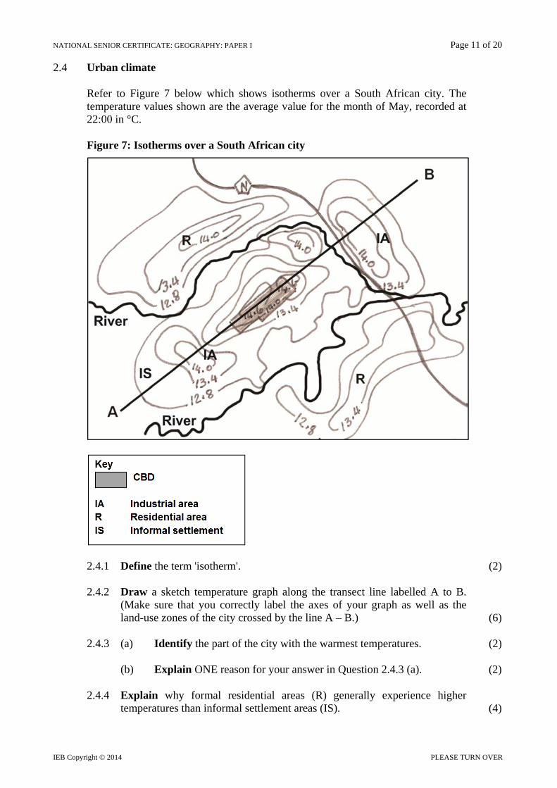
2.4 Urban climate
Refer to Figure 7 below which shows isotherms over a South African city. The temperature values shown are the average value for the month of May, recorded at 22:00 in °C. Figure 7: Isotherms over a South African city
2.4.1 Define the term 'isotherm'. (2) 2.4.2 Draw a sketch temperature graph along the transect line labelled A to B.
(Make sure that you correctly label the axes of your graph as well as the land-use zones of the city crossed by the line A – B.) (6)
2.4.3 (a) Identify the part of the city with the warmest temperatures. (2) (b) Explain ONE reason for your answer in Question 2.4.3 (a). (2) 2.4.4 Explain why formal residential areas (R) generally experience higher
temperatures than informal settlement areas (IS). (4)
NATIONAL SENIOR CERTIFICATE: GEOGRAPHY: PAPER I Page 12 of 20
IEB Copyright © 2014
2.5 Fluvial terminology
Match the word(s) in column A with the correct statement in column B. Write ONLY the number and the correct letter, for example 2.5.1 – A.
Column A Column B
2.5.1 Graded profile A Rivers flow outwards from a central highland
2.5.2
Superimposed drainage
B A waterfall along the longitudinal profile of a river
2.5.3
Dendritic drainage pattern
C River is younger than the landscape
2.5.4 Exotic river D Concave longitudinal profile of a river
E River is older than the landscape
F
A river that rises in a well-watered highland and flows for most of its course through arid landscapes
G A branching, tree-like drainage pattern
(8)
2.6 Fluvial landforms and processes
Study Photograph 10 on page (iii) of the colour Insert. 2.6.1 Draw a well-labelled sketch of the river shown in Photograph 10. Label and
identify the following features on your sketch in your Answer Book:
the under-cut and slip-off slopes of a meander a previous floodplain levee river terraces (8)
2.6.2 A river valley such as the one shown in Photograph 10 (page (iii) of the
colour Insert) poses advantages and disadvantages for agriculture. List ONE advantage and ONE disadvantage of farming along this river. (4)
NATIONAL SENIOR CERTIFICATE: GEOGRAPHY: PAPER I Page 13 of 20
IEB Copyright © 2014 PLEASE TURN OVER
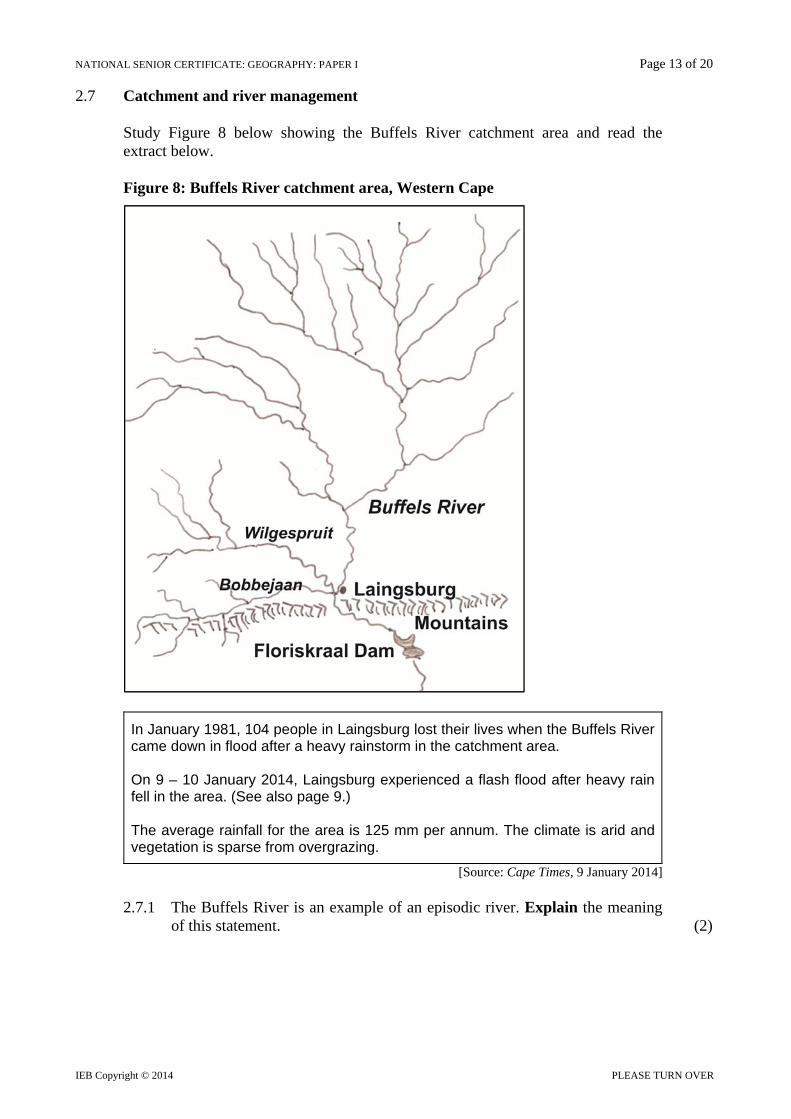
2.7 Catchment and river management
Study Figure 8 below showing the Buffels River catchment area and read the extract below. Figure 8: Buffels River catchment area, Western Cape
In January 1981, 104 people in Laingsburg lost their lives when the Buffels River came down in flood after a heavy rainstorm in the catchment area. On 9 – 10 January 2014, Laingsburg experienced a flash flood after heavy rain fell in the area. (See also page 9.) The average rainfall for the area is 125 mm per annum. The climate is arid and vegetation is sparse from overgrazing.
[Source: Cape Times, 9 January 2014] 2.7.1 The Buffels River is an example of an episodic river. Explain the meaning
of this statement. (2)

NATIONAL SENIOR CERTIFICATE: GEOGRAPHY: PAPER I Page 14 of 20
IEB Copyright © 2014
2.7.2 The municipality of Laingsburg has commissioned the local Water Department to carry out a study to make recommendations for a catchment area management strategy for the Buffels River basin.
Write a 1½ to 2 page report in which you analyse the contributing factors below. Shape and size of the drainage basin River flow and rainfall patterns Drainage density and stream ordering Surface vegetation
Include your recommendations for a catchment area management strategy to be implemented by the department. (16)
100 marks

NATIONAL SENIOR CERTIFICATE: GEOGRAPHY: PAPER I Page 15 of 20
IEB Copyright © 2014 PLEASE TURN OVER
SECTION C RURAL AND URBAN SETTLEMENT AND ECONOMIC GEOGRAPHY OF SOUTH AFRICA
QUESTION 3 3.1 Urban structure and patterns
Multiple choice: Select the most appropriate answer from the list for each question. Write down only the number and the correct answer. For example: 3.1.1 – A.
3.1.1 The main function of the Central Business District (CBD) is … A manufacturing activities B retail and service activities C selling of low order goods D residential 3.1.2 The transition zone is mainly situated next to the … A CBD B heavy industry zone C rural-urban fringe D light manufacturing zone 3.1.3 The street pattern of New York City
depicted in the photograph alongside is best described as …
A radial B cobweb C grid D irregular
[Source: Examiner's photograph]
3.1.4 The urban land use model that strictly divides a city according to the race of
the inhabitants is called the ... A LEDC city model B MEDC city model C multiple nuclei model D apartheid city model 3.1.5 Most high-order goods in MEDC cities are found in the/a … A spaza shop B corner shop C local shopping centre D regional shopping centre (10)

NATIONAL SENIOR CERTIFICATE: GEOGRAPHY: PAPER I Page 16 of 20
IEB Copyright © 2014
3.2 Settlement issues, new ruralism and eco-estates
Study the Fact File on rural gated developments in the Western Cape
Fact File: Rural gated developments in the Western Cape Gated developments are not only found in urban areas, but have also
increasingly become part of the rural locale in South Africa.
These rural gated developments such as Benguela Cove Lagoon Wine Estate offer security, community and leisure/amenity activities in an idyllic rural setting.
They can be seen as an example of counterurbanism.
The rural domain is transformed into an urbanised rurality.
The value of previously agricultural land has increased dramatically.
[Adapted from M. Spocter, South African Geographical Journal, Vol. 95, 2013]
3.2.1 Explain the following terms in the Fact File: (a) Gated developments (b) Urbanised rurality (4) 3.2.2 List FOUR possible 'leisure/amenity activities' that these gated
developments could offer. (4) 3.2.3 The development Benguela Cove Lagoon Wine Estate is an example of
counter-urbanism. Explain why such developments are growing in popularity. (6) 3.2.4 Justify your opinion as to whether rural gated developments in South Africa
contribute to social justice issues in rural areas. (8)
NATIONAL SENIOR CERTIFICATE: GEOGRAPHY: PAPER I Page 17 of 20
IEB Copyright © 2014 PLEASE TURN OVER
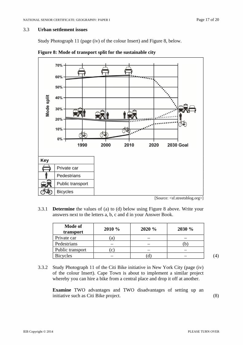
3.3 Urban settlement issues
Study Photograph 11 (page (iv) of the colour Insert) and Figure 8, below.
Figure 8: Mode of transport split for the sustainable city
Key
Private car
Pedestrians
Public transport
Bicycles [Source: <sf.streetsblog.org>]
3.3.1 Determine the values of (a) to (d) below using Figure 8 above. Write your
answers next to the letters a, b, c and d in your Answer Book.
Mode of transport
2010 % 2020 % 2030 %
Private car (a) – – Pedestrians – – (b) Public transport (c) – – Bicycles – (d) – (4)
3.3.2 Study Photograph 11 of the Citi Bike initiative in New York City (page (iv)
of the colour Insert). Cape Town is about to implement a similar project whereby you can hire a bike from a central place and drop it off at another.
Examine TWO advantages and TWO disadvantages of setting up an
initiative such as Citi Bike project. (8)
NATIONAL SENIOR CERTIFICATE: GEOGRAPHY: PAPER I Page 18 of 20
IEB Copyright © 2014
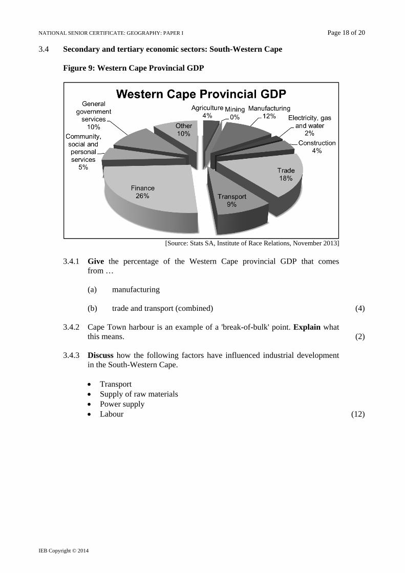
3.4 Secondary and tertiary economic sectors: South-Western Cape
Figure 9: Western Cape Provincial GDP
[Source: Stats SA, Institute of Race Relations, November 2013]
3.4.1 Give the percentage of the Western Cape provincial GDP that comes
from …
(a) manufacturing
(b) trade and transport (combined) (4) 3.4.2 Cape Town harbour is an example of a 'break-of-bulk' point. Explain what
this means. (2) 3.4.3 Discuss how the following factors have influenced industrial development
in the South-Western Cape.
Transport Supply of raw materials Power supply Labour (12)

NATIONAL SENIOR CERTIFICATE: GEOGRAPHY: PAPER I Page 19 of 20
IEB Copyright © 2014 PLEASE TURN OVER
3.5 Economic Geography terminology
Match the words in Column A with the correct statement in Column B. Write ONLY the number and correct letter, for example 3.5.1 – A.
Column A Column B
3.5.1 Ubiquitous industry A Located along main transport routes around which economic activities grow
3.5.2 Tertiary activities B Located close to the source of raw materials
3.5.3 Spatial Development Initiative
C Located over the entire geographic area
3.5.4 Quaternary activities E Tourism service provider is an example
D Viticulture is an example
F Geoinformation Science is an example (8)
3.6 Informal sector
3.6.1 Explain what 'informal trading' is. (2) 3.6.2 Refer to Photographs 12 and 13 (page (iv) of the colour Insert) and
comment on the challenges facing South Africa's informal economic sector. (8)
NATIONAL SENIOR CERTIFICATE: GEOGRAPHY: PAPER I Page 20 of 20
IEB Copyright © 2014
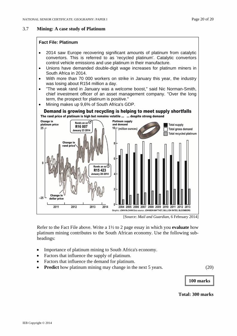
3.7 Mining: A case study of Platinum
Fact File: Platinum 2014 saw Europe recovering significant amounts of platinum from catalytic
convertors. This is referred to as 'recycled platinum'. Catalytic convertors control vehicle emissions and use platinum in their manufacture.
Unions have demanded double-digit wage increases for platinum miners in South Africa in 2014.
With more than 70 000 workers on strike in January this year, the industry was losing about R154 million a day.
"The weak rand in January was a welcome boost," said Nic Norman-Smith, chief investment officer of an asset management company. "Over the long term, the prospect for platinum is positive."
Mining makes up 9,6% of South Africa's GDP.
[Source: Mail and Guardian, 6 February 2014]
Refer to the Fact File above. Write a 1½ to 2 page essay in which you evaluate how platinum mining contributes to the South African economy. Use the following sub-headings:
Importance of platinum mining to South Africa's economy. Factors that influence the supply of platinum. Factors that influence the demand for platinum. Predict how platinum mining may change in the next 5 years. (20)
100 marks
Total: 300 marks


![2019/2020 - UP · NSC/IEB AS Level NSC/IEB AS Level NSC/IEB AS Level School of Dentistry BChD – Bachelor of Dental Surgery [5 years] Closing dates: SA – 31 May Non-SA – 31 May](https://img.pdfslide.us/doc/110x75/60468b1fc073b12ae527eba9/20192020-up-nscieb-as-level-nscieb-as-level-nscieb-as-level-school-of-dentistry.jpg)