Embed Size (px)
Citation preview

GeographyGeographyLatitude and LongitudeLatitude and Longitude
SolutionsSolutions

Latitude linesLatitude linesRun East to West Parallel to the EquatorRun East to West Parallel to the Equator
Measures degrees North or South of the EquatorMeasures degrees North or South of the Equator

Longitude linesLongitude lines Run North to South fromRun North to South fromNorth Pole to South Pole.North Pole to South Pole.
Measures degrees East or Measures degrees East or
West of the Prime Meridian.West of the Prime Meridian.

Fill in the BlankFill in the Blank1.1. Lines of latitude are drawn in a(n) Lines of latitude are drawn in a(n)
_____________________ direction. _____________________ direction. East -to- WestEast -to- West
2.2. Lines of longitude are drawn in a(n) Lines of longitude are drawn in a(n) _____________________ direction. _____________________ direction.
North -to- SouthNorth -to- South
3.3. The intersection of Longitude and Latitude lines help The intersection of Longitude and Latitude lines help us find the exact or absolute _________________ of us find the exact or absolute _________________ of places. places.
locationlocation
4.4. Lines of latitude measure distance North and South of Lines of latitude measure distance North and South of the ______________ . the ______________ .
EquatorEquator
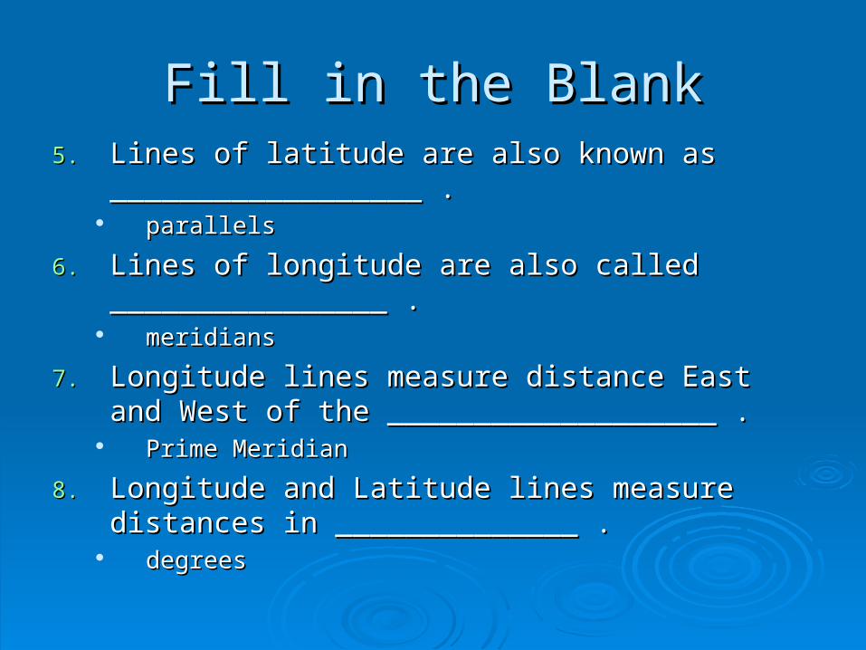
Fill in the BlankFill in the Blank5.5. Lines of latitude are also known as Lines of latitude are also known as
__________________ .__________________ . parallelsparallels
6.6. Lines of longitude are also called ________________ .Lines of longitude are also called ________________ . meridiansmeridians
7.7. Longitude lines measure distance East and West of Longitude lines measure distance East and West of the ___________________ .the ___________________ .
Prime MeridianPrime Meridian
8.8. Longitude and Latitude lines measure distances in Longitude and Latitude lines measure distances in ______________ .______________ .
degreesdegrees

Fill in the BlankFill in the Blank9.9. Degrees are further divided into _____________ . Degrees are further divided into _____________ .
minutesminutes
10.10. The symbol for degrees is ______. The symbol for The symbol for degrees is ______. The symbol for minutes is ______. minutes is ______.
Degrees Degrees Minutes Minutes (36(36 3 3 NorthNorth, -80, -80 23 23 WestWest) where is this?) where is this?
11.11. The equator divides the planet into ________ and The equator divides the planet into ________ and ________ hemispheres. ________ hemispheres.
North and SouthNorth and South
12.12. The different ways of presenting a round Earth on flat The different ways of presenting a round Earth on flat maps are called ______ ____________ . maps are called ______ ____________ .
Map projectionsMap projections

Map ProjectionsMap Projections
Two dimensional maps are Two dimensional maps are made by placing a light inside made by placing a light inside of a globe and projecting the of a globe and projecting the different continents, islands, different continents, islands, and other features onto a flat and other features onto a flat screen. What the projection screen. What the projection looks like depends on where looks like depends on where you place the screen.you place the screen.

Map ProjectionsMap Projections
Fill in the BlankFill in the Blank13.13. __________ projections are designed as __________ projections are designed as
if a ________ has been placed over the if a ________ has been placed over the globe. It retains almost _______ globe. It retains almost _______ __________ and________ of land __________ and________ of land masses. masses.
ConicConic conecone true shapestrue shapes sizessizes

Conic ProjectionConic Projectionproduces a fan shaped mapproduces a fan shaped map

Fill in the BlankFill in the Blank14.14. _____________ maps are those that _____________ maps are those that
appear to touch the globe at one point appear to touch the globe at one point such as the North or South Pole. They such as the North or South Pole. They show true ___________ but _________ show true ___________ but _________ shapes. shapes.
Flat-planeFlat-plane areaarea shapesshapes

Flat-plane ProjectionFlat-plane Projection

Fill in the BlankFill in the Blank15.15. The shortest distance between any two places The shortest distance between any two places
is called the _________ _________ is called the _________ _________ __________ . This is not a straight line on a __________ . This is not a straight line on a flat map because the world is ____________ . flat map because the world is ____________ .
great circle routegreat circle route roundround

Fill in the BlankFill in the Blank16.16. Define: compass rose. Define: compass rose.
A directional indicator on maps that has A directional indicator on maps that has arrows pointing in all four principal, or arrows pointing in all four principal, or cardinal, directions. cardinal, directions.
NOTE: North is not always “up”.NOTE: North is not always “up”.

Fill in the BlankFill in the Blank17.17. Define: Contiguous. Define: Contiguous.
Means connecting or bordering and is often Means connecting or bordering and is often used to refer to the “lower” 48 states as the used to refer to the “lower” 48 states as the “contiguous United States”.“contiguous United States”.

Matching (Latitude or Longitude)Matching (Latitude or Longitude)The EquatorThe Equator
LatitudeLatitude
They run from the North to the South PoleThey run from the North to the South PoleLongitudeLongitude
They They are notare not all the same size all the same size LatitudeLatitude
They are all the same sizeThey are all the same size LongitudeLongitude
They are They are labeledlabeled as either East or West as either East or West LongitudeLongitude

Matching (Latitude or Longitude)Matching (Latitude or Longitude)
They are They are labeledlabeled as either North or South as either North or South LatitudeLatitude
Prime MeridianPrime Meridian LongitudeLongitude
They are all parallel to each otherThey are all parallel to each other LatitudeLatitude
They only go up to 90°They only go up to 90° LatitudeLatitude
GreenwichGreenwich LongitudeLongitude

Short Answer Short Answer (complete sentences)(complete sentences)
You travel to 90° North Latitude. Where You travel to 90° North Latitude. Where are you? are you? I am at the North Pole.I am at the North Pole.
Name one country you will pass through if Name one country you will pass through if you travel along the Prime Meridian. you travel along the Prime Meridian. I will pass through England.I will pass through England.