Embed Size (px)
Citation preview
B.A. (Hons) Geography Syllabus
CHOICE BASED CREDIT SYSTEM (CBCS)
S.C.S. (A) College, Puri
Academic Session
2015-18
CBCS - B.A. Geography (Hons) Syllabus
CBCS – (B.A.) Geography Honours
S.C.S. (A) College, Puri
1
+3 1st Year
SEMESTER – I
Paper- 1 GEOGC-1(Theory) Credits-4 Marks-75
Geomorphology Unit 1: Nature, Scope & 5 fundamental concepts of geomorphology
Unit II: Interior of the earth, Isostasy, Continental theory, Plate Tectonics.
Unit III: Earthquakes, Volcanoes, Muntain building theory of Kober and Holmes
Unit IV: Features produced in Fluvial, Aeolian, Glacial topography.
Unit V: Weathering, Mass Wasting, Cycle of Erosion (Davis and Penck)
Paper- 1 GEOGC-1(Practical) Credits-2 Marks- 25
Practical 1. Interpretation of topographical maps and drawing of profiles
2. Drawing of cross section from geological maps and interpretation
3. Practical records and viva -voce
Paper- 2 GEOGC-2 (Theory) Credits-4 Marks-75
Cartographic Techniques Unit – I: Nature of cartography: a) Forms of representation and needs of map making,
characteristics of maps, Categories of maps. b) Scope of cartography c) branches
of cartography
Unit – II: History of cartography –a) Primitive, medieval and modern period b) Impact of
changing ideas and technology c) electronic technology and digitization of maps
Unit – III: Basic Geodesy – a) Spherical earth, Ellipsoidal earth, Geoidal earth b)
Cartographic use of the sphere, ellipsoid and geoid c) geographical coordinates –
latitude and longitude
Unit – IV: Map Projections –a) Meaning and needs b) Use of developable surface c)
Classification, and properties.
Unit – V: Map making –a) Relief maps and diagram b) climatic maps and diagram c)
Socioeconomic maps and Diagram
Paper- 2GEOGC-2(Practical) Credits-2 Marks- 25
1. Cartograms –Complex bar, wheel diagram, cube diagrams
2. Maps drawing –Dot maps, Choropleth maps (taking two indicators)
3. Practical record and viva-voce
Paper- 3 GEOGAECC-1 Credits-2 Marks-50
(English/M.I.L Communication)/Environmental Science
CBCS – (B.A.) Geography Honours
S.C.S. (A) College, Puri
2
Paper-4 GEOGGE-1(Theory) Credits-4 Marks-75
Rural Development/Other related discipline
1. Defining Development: Inter-Dependence of Urban and Rural Sectors of the Economy;
Need for Rural Development, Gandhian Concept of Rural Development.
2. Rural Economic Base: Agriculture and Allied activities, Need for Expanding Non-Farm
Activities.
3. Area Based Approach to Rural Development: Drought Prone Area Programmes,
PMGSY.
4. Target Group Approach to Rural Development: SJSY (Integrated Rural Development
Programme).
5. Provision of Services – Physical and Socio-Economic Access to Elementary Education
and Primary Health Care and Micro credit
Paper-4 GEOGGE-1(Practical) Credits-2 Marks-25 Rural Development/Other related discipline 1. Cartograms – Pair-Bar diagram, complex bar, wheel diagram 2. Maps drawing –Simple dot maps, Multiple dot maps
3. Practical record and viva-voce
SEMESTER – II
Paper- 5 GEOGC-3 (Theory) Credits-4 Marks-75
Climatology Unit I. Atmospheric Composition and Structure. Insolation and Temperature – Factors and
Distribution, Heat . . . Budget, Temperature Inversion.,
Unit II. Atmospheric Pressure and Winds – Planetary Winds, Forces affecting Winds, General Circulation, Jet
Streams.
Unit III. Atmospheric Moisture – Evaporation, Humidity, Condensation, Fog and Clouds, Types of cloud.
Precipitation and its type
Unit IV. Cyclones – Tropical Cyclones, Extra Tropical Cyclones, Monsoon - Origin and Mechanism.
Unit V. Airmass- Source region characteristics, types and modification.
Paper- 5 GEOGC-3 (Practical) Credits-2 Marks-25
Practical:- 1. Interpretation of weather map, Weather forecasting.
2. Drawing of graphs showing rainfall, temperature, humidity ,
3. Drawing of Climograph and Hythergraph. Wind rose diagram).
4. Practical records and viva -voce
Paper-6 GEOGC-4 (Theory) Credits-4 Marks-75
Thematic Cartography
Unit I: Definition and Types of Thematic Maps, Factors Associated with Thematic map,
Choice of Base ,Maps, Data and Their Representation, Data Generalization,
Standardization of Symbols, Compilation of Data, Design of Maps, Cartographic
Equipment’s, Drawing Media, Map compilation,
Unit II: Cartographic design: Function and scope of design, Limitation and constraints in
Map Designing ,Concept of Map symbolization: Use of Point, Line and Area
symbols, Conventional Signm,Symbols of physical and cultural themes on maps,
CBCS – (B.A.) Geography Honours
S.C.S. (A) College, Puri
3
Unit III: Mapping the terrain, Relief representation by different methods: Spot height,
Bench Marks , Hachuring, Hill Shadings, Use of Contours in Representation of
Relief, Gradient and Slope Significance, Calculation of Gradient, Methods of
average slope determination (Raisz& Henry ,Method, Wentworth’s method,
Smith’s method),
Unit IV: Mapping Qualitative Data: Use of Pictures and Symbols (Simple and Multiple
Dots), Picturial ,Maps, Mapping Spatial Variation using Quantitative Data using
Diagrams; One Dimensional (Simple and Complex Bars) Two Dimensional
(Circles and Pie Diagrams) Three Dimensional (Spheres and Block Diagrams
Mapping Spatial Variation Using the Techniques of Choropleth.andIsopleths.
Unit V: Indexing of Topographic Maps and Map Numbering System, Interpretation and
analysis of physical details, Interpretation and Analysis of Cultural Details and
Settlement Patterns, Interpretation of Cadastral Maps, Symbols in Cadastral
Maps, Measurement on Cadastral Map
Paper-6 GEOGC-4 (Practical) Credits-2 Marks-25
Practical
1. Construction and use of Graphical Scale, R.F., Statement Scale, Diagonal Scale
2. Construction of dot maps( simple and multiple),propionate circle
3. Construction of: Spheres and Block diagrams
4. Drawing of Isopleths using spot height/ rainfall / temperature / pressure
5. Drawing of Choropleths using population density / literacy
6. Practical records and viva -voce
Paper-8 GEOGGE-2(Theory) Credits-4 Marks-75
Industrial Geography
Unit I. Nature, Scope and Subject Matter of Industrial Geography
Unit II. Types, Geographical Characteristics and Location of Industries: Small and
Medium
Enterprises, Coal and Iron, Tertiary Industries, Rural based Industries.
Unit III. Mega Industrial Complexes: National Capital Region, Mumbai-Pune Industrial
Region, Bengaluru-Tamil Nadu Industrial Region and Chota Nagpur Industrial
Region.
Unit IV: Impact of Industrialization in India: Environmental; Social and Economic
Unit V Industrial Policy of India
Paper-8 GEOGGE-2(Practical) Credits-2 Marks-25
Report on a particular industry of your region 1. Selection of project topic for study of an industry
2. Data collection.
3. Compilation and analysis of data,
4. Preparation of chart and diagrams.
5. Interpretation and preparation of project
CBCS – (B.A.) Geography Honours
S.C.S. (A) College, Puri
4
SEMESTER – III Paper-9 GEOGC-5 (Theory) Credits-4Marks-75
Environmental Geography
Unit I: Environmental Geography – Concept and Scope, Environmental contrast(biotic and abiotic,
global, continental, local ) Environmental control (light, temperature,topography , water
edaphic factor)
Unit II: Environmental zones and their classification, concept of biomes
Unit III: Ecosystem – Concept, Structure and Functions , basic ecological principle, trophic level and
food chains, biogeochemical cycle , energy flow in ecosystem.
Unit IV: Enviromentalpollution : causes ,consequences an management(land , air ,water)
Unit V: Man environmental relationship :Historicalprogression,Adaption, Disharmony
between man and nature; global ecological imbalance, achieving balance; concept
of spaceship earth Paper-9 GEOGC-5 (Practical) Credits-2 Marks-25
Practical 1. Drawing of maps to showthe relief, soil,and vegetation.
2. Drawing of maps to show the amenities of the area
3. Representation of population data by small squares, proportionate circle, divided rectangle.
4. Practical records and viva -voce
Paper-10 GEOGC-6(Theory) Credits-4 Marks-75
Economic Geography
Unit I: Introduction: Concept and classification of economic activity
Unit II: Factors Affecting location of Economic Activity with special reference to
Agriculture, locational theory of Vonthunen ; Industry andlocational theory of
weber
Unit III: Primary Activities: Subsistence and Commercial agriculture, forestry, fishing and
mining.
Unit IV: Secondary Activities: Manufacturing (Cotton Textile, Iron and Steel),
Unit V: Tertiary Activities: Transport, Trade and Services.Concept of Manufacturing
Regions, Special Economic Zones and Technology Parks.
Paper-10 GEOGC-6(Practical) Credits-2 Marks-25
Practical 1. Determination of agricultural efficiency (Kendal and Bhatia method) and to show on maps
2. Drawing of isotims and isodapane.
3. Representation of transport data –traffic flow diagram, isochronic map
4. Practical records and viva -voce
Paper-11GEOGC-7 (Theory) Credits-4 Marks-75
Field Work and Research Methodology
Unit I: Field Work in Geographical Studies – Role, Value and Ethics of Field-Work
Unit II: Defining the Field and Identifying the Case Study – Rural / Urban / Physical /
Human / Environmental.
CBCS – (B.A.) Geography Honours
S.C.S. (A) College, Puri
5
Unit III: Field Techniques – Merits, Demerits and Selection of the Appropriate Technique;
Observation (Participant / Non Participant), Questionnaires (Open/ Closed /
Structured / Non-Structured); Interview with Special Focus on Focused Group
Discussions; Space Survey (Transects and Quadrants, Constructing a Sketch)
Unit IV: Use of Field Tools – Collection of Material for Physical and Socio-Economic
Surveys.
Unit V: Designing the Field Report – Aims and Objectives, Methodology, Analysis,
Interpretation and Writingthe Report.
Paper-11GEOGC-7(Practical) Credits-2 Marks-25
1. Each student will prepare an individual report based on primary and secondary data
collected during field work.
2. The students / teachers can opt to take students in or outside the NCR, depending upon,
problem to be studied.
3. The duration of the field work should not exceed 10 days.
4. The word count of the report should be about 8000 to 12,000 excluding figures, tables,
photographs, maps, references and appendices.
5. Report in soft and hard copy and viva
Paper-12 GEOGSEC-1 Credits-2 Marks-50
Not applicable
Paper-13 GEOGGE-3(Theory) Credits-4 Marks-75
Geography of Tourism/Other related discipline 1. Scope and Nature: Concepts and Issues, Tourism, Recreation and Leisure Inter-Relations;
Geographical Parameters of Tourism by Robinson; Type of Tourism: Nature Tourism,
Cultural Tourism, Medical Tourism, Pilgrimage
2. Recent Trends of Tourism: International and Regional; Domestic (India); Eco-Tourism,
Sustainable Tourism, Meetings Incentives Conventions and Exhibitions (MICE)
3. Impact of Tourism: Economy; Environment; Society
4. Tourism in India: Tourism Infrastructure; Case Studies of Himalaya, Desert and Coastal
Areas; National Tourism Policy
Paper-13 GEOGGE-3(Practical) Credits-2 Marks-25
Practical
1. Drawing of cartograms – Pair bar diagram ,Complex bar diagram, wheel diagram
2. Drawing of maps – Choropleth
3. Practical records and viva -voce
SEMESTER – IV
Paper-14 GEOGC-8 Credits-4 Marks-75
Evolution of Geographical Thought 1. Paradigms in Geography
CBCS – (B.A.) Geography Honours
S.C.S. (A) College, Puri
6
2. Pre-Modern – Early Origins of Geographical Thinking with reference to the Classical and
Medieval Philosophies.
3. Modern – Evolution of Geographical Thinking and Disciplinary Trends in Germany,
France, Britain, United States of America.
4. Debates – Environmental Determinism and Possibilism, Systematic and Regional,
Ideographic and Nomeothetic.
5. Trends – Quantitative Revolution and its Impact, Behaviouralism, Systems Approach,
Radicalism, Feminism; Towards Post Modernism – Changing Concept of Space in
Geography, Future of Geography.
Paper-14 GEOGC –8 (Practical)Credits-2 Marks-25 1. Types of map projection, properties and uses
2. Drawing of projection (Cylindrical- simple and cylindrical equal area
3. Drawing of projection (simple Conical with one standard parallel and two standard
parallel, poly conic)
4. Drawing of projection (Gnomonic, Stereographic, Ortographic)
5. Practical records and viva -voce
Paper-15 GEOGC-9(Theory) Credits-4 Marks-75
Statistical Methods in Geography 1. Use of Data in Geography: Geographical Data Matrix, Significance of Statistical
Methods in Geography; Sources of Data, Scales of Measurement (Nominal, Ordinal,
Interval, Ratio).
2. Tabulation and Descriptive Statistics: Frequencies (Deciles, Quartiles), Cross Tabulation,
Central Tendency (Mean, Median and Mode, Centro-graphicTechniques, Dispersion
(Standard Deviation, Variance and Coefficient of Variation).
3. Sampling: Purposive, Random, Systematic and Stratified.
4. Theoretical Distribution: Probability and Normal Distribution.
5. Association and Correlation: Rank Correlation, Product Moment Correlation, and Simple
Regression,
Paper-15 GEOGC-9(Practical) Credits-2 Marks-2
1. Drawing of histogram frequency curve, frequency polygon, ogive 2. Drawing of graphs showing mean, median, mode and quartile 3. Calculation of correlation coefficient (spearman rank, Karl person product moment)
4. Drawing of regression line
5. Practical records and viva -voce
Paper-16 GEOGC-10(Theory) Credits-4 Marks-75
Human Geography 1. Definition, Nature, Scope, Major Subfields, Contemporary Relevance.
2. Space and Society: Cultural Regions; Race; Religion and Language
3. Population: Population Growth and Demographic Transition Theory, Application in
India;
CBCS – (B.A.) Geography Honours
S.C.S. (A) College, Puri
7
4. Population Distribution; Population Composition (Age, Gender, Race and Religion).
5. Settlements: Types and Patterns of Rural Settlements; Types of Urban Settlements;
Trends and Patterns of World Urbanization
Paper-16 GEOGC-10(practical) Credits-2 Marks-25
Practical 1. Drawing of age sex pyramid
2. Drawing maps showing to show density of population
3. Drawing of Sphere diagram on map
4. Enlargement and reduction of maps
5. Practical records and viva -voce
Paper-17 GEOGSEC-2 Credits-6 Marks-100
N.A
Paper-18 GEOGGE-4 (Theory)Credits-4 Marks-75
Disaster Management /Other related discipline 1. Disasters: Definition and Concepts: Hazards, Disasters; Risk and Vulnerability;
Classification
2. Disaster in India: (a) Flood: Causes, Impact, Distribution and Mapping; Landslide:
Causes, Impact, Distribution and Mapping; Drought: Causes, Impact, Distribution and
Mapping
3. Disaster in India: (b) Earthquake and Tsunami: Causes, Impact, Distribution and
Mapping; Cyclone: Causes, Impact, Distribution and Mapping; Manmade disasters:
Causes, Impact, Distribution and Mapping
4. Response and Mitigation to Disasters: Mitigation and Preparedness, NDMA and NIDM;
Indigenous Knowledge and Community-Based
Disaster Management; Do’s and Don’ts During Disaster
Paper-18 GEOGGE-4 (Practical)Credits-2 Marks-25 Report on a particular topic of your region 1. Selection of project topic
2. Data collection.
3. Compilation and analysis of data,
4. Preparation of chart and diagrams.
5. Interpretation and preparation of project
6. Report and viva
Year – 3
SEMESTER-V
Paper-19 GEOGC-11(Theory) Credits-4 Marks-75
Geography of India 1. Physical: Physiographic Divisions, Drainage
2. C limate , soil and vegetation.
3. Agricultural -production and distribution of rice , wheat, cotton ,sugarcane; Mineral and
power resources distribution and utilisation of iron ore, coal, petroleum,
CBCS – (B.A.) Geography Honours
S.C.S. (A) College, Puri
8
4. Industry –production and distribution of iron and steel, alluminium,cotton textile
5. Population: Distribution and growth, rural –urban population, trends of urbanisation
Paper-19 GEOGC-11(Practical) Credits-2 Marks-25 1. Use of instrument – measurement of length of river or road and area by the help of
planimeter and rotameter.
2. Chain and tape survey
3. Plane table survey
4. Practical record and viva
Paper-20 GEOGC-12(Theory) Credits-4 Marks-75
Remote Sensing and GIS (Practical) 1. Remote Sensing - Definition, Components, history and development, Platforms and
types: Principles of Remote Sensing,
2. Satellite Remote Sensing, EMR Interaction with Atmosphere and Earth, Surface;
Satellites (Landsat and IRS) and Sensors. Concept of signature, data reception and data
products, data analysis
3. GIS- Definition , Components, history and development, characteristics of data base
system, G.I.S data structure- types (spatial and Non-spatial), Raster and Vector.
4. Image Processing (Digital and Manual) and Data Analysis: Pre-processing (Radiometric
and Geometric Correction), Enhancement (Filtering); Classification (Supervised and Un-
supervised), Geo- Referencing; Editing and Output;
5. Data input and editing, error and its sources, G.I.S. operation, project design and
management application
Paper-20 GEOGC-12(Practical) Credits-2 Marks-25 1. Interpretation and Application of Remote Sensing and GIS: Land use/ Land Cover,
2. Urban Sprawl Analysis
3. Forests Monitoring
4. Practical record and viva
Paper-21 GEOGDSE-1(Theory) Credits-4 Marks-75
Population Geography 1. Defining the Field – Nature and Scope; Sources of Data with special reference to India
(Census, Vital Statistics and NSS).
2. Population Size, Distribution and Growth – Determinants and Patterns; Theories of
Growth –Malthusian Theory and Demographic Transition Theory.
3. Population Dynamics: Fertility, Mortality and Migration – Measures, Determinants and
Implications.
4. Population Composition and Characteristics – Age-Sex Composition; Rural and Urban
Composition; Literacy,occupational structure
5. Contemporary Issues – Ageing of Population; Declining Sex Ratio; HIV/AIDS.
Paper-21 GEOGDSE-1(Practical) Credits-2 Marks-25 1. Population projection by various methods
2. Drawing of triangular diagram and lorenge curve
3. Construction of compund and superimposed pyramids
4. Practical record and viva
CBCS – (B.A.) Geography Honours
S.C.S. (A) College, Puri
9
Paper-22 GEOGDSE-2(Theory) Credits-4 Marks-75
Hydrology and Oceanography 1. Hydrological Cycle: Systems approach in hydrology, human impact on the hydrological
cycle; Precipitation, interception, evaporation, evapo-transpiration, infiltration, ground-
water, run off and over land flow.
2. River Basin and Problems of Regional Hydrology: Characteristics of river basins, basin
surface run-off, measurement of river discharge; floods and droughts.
3. Ocean Floor Topography and Oceanic Movements – Waves, Currents and Tides.
4. Ocean Salinity and Temperature – Distribution and Determinants.
5. Coral Reefs and Marine Deposits and Ocean Resources: Types and Theories of Origin;
Biotic, Mineral.
Paper-22 GEOGDSE-2(Practical) Credits-2 Marks-25 1. Survey by Prismatic Compass
2. Survey by The odolite (horizontal and vertical)
3. Levelling by Dumpy level
4. Practical record and viva
SEMESTER – VI
Paper-23 GEOGC-13(Theory) Credits-4 Marks-75
Regional Planning and Development
1. Definition and types of region - Formal, Functional .regions and regional Planning; need
for regional planning; Hierarchy concept
2. Choice of a region for Planning: Characteristics of an Ideal Planning Region; Delineation
of Planning Region; Regionalization of India for Planning (Agro Ecological Zones)
3. Theories and Models for Regional Planning: Growth Pole; Growth Centre and economic
base theory
4. Changing Concept of Development, level of regional disparities vs diversitities, balance
regional development- backward area development,
5. Measuring development: Indicators (Economic, Social and Environmental), human
development index .
Paper-23 GEOGC-13(Practical) Credits-2 Marks-25
Practical 1. Transport network analysis –Alfa, Beta, Gama and detour indices
2. Nearest neighbour analysis
3. Determination of service center
4. Practical record and viva
Paper-24 GEOGC-14(Theory) Credits-4 Marks-75
Disaster Management based Project Work (Practical) 1. Disasters: Definition and Concepts: Hazards, Disasters; Risk and Vulnerability;
Classification
2. Disaster in India: (a) Flood: Causes, Impact, Distribution and Mapping; Landslide:
Causes, Impact, Distribution and Mapping; Drought: Causes, Impact, Distribution and
Mapping
CBCS – (B.A.) Geography Honours
S.C.S. (A) College, Puri
10
3. Disaster in India: (b) Earthquake and Tsunami: Causes, Impact, Distribution and
Mapping; Cyclone: Causes, Impact, Distribution and Mapping; Manmade disasters:
Causes, Impact, Distribution and Mapping
4. Response to Disasters: Resque, relief, reconstruction, planning, preparedness, Indigenous
knowledge and community based knowledge
5. Disaster Management; Do’s and Don’ts during Disaster, mechanism India and Odisha
Paper-24 GEOGC-14(Practical) Credits-2 Marks-25
Disaster management based project work 1. Selection of project topic
2. Data collection.
3. Compilation and analysis of data,
4. Preparation of chart and diagrams.
5. Interpretation and preparation of project
6. Report and viva
Paper-25 GEOGDSE-3(Theory) Credits-4 Marks-75
Urban Geography 1. Urban geography -, Nature and scope; origin and growth of urban settlement, history of
urbanization.
2. Morphology of urban settlement, urban land use pattern, urban land use theory
3. Functional classification of cities: Quantitative and Qualitative Methods, Rank size rule,
urban sphere of influence
4. Urban Issues: problems of housing, slums, civic amenities (water and transport)
5. Case studies of Delhi, Mumbai, Kolkata and Chennai with reference to Urban Issues
Paper-25 GEOGDSE-3(Practical) Credits-2 Marks-25 1. Functional classification of towns
2. Delimitation of C.B.D
3. Delemitation of urban sphere of influence
Paper-26 GEOGDSE-4 Credits-6 Marks-100
Project Report Introducing Research Component in Under-Graduate Courses
Project work/Dissertation is considered as a special course involving application of knowledge
in solving / analyzing /exploring a real life situation / difficult problem. A Project/Dissertation
work would be of 6 credits. A Project/Dissertation work may be given in lieu of a discipline
specific elective paper.
SEMESTER – II
Paper- 5 GEOGC-3 Credits-6 Marks-100
Climatology: 1. Atmospheric Composition and Structure – Variation with Altitude, Latitude and Season.
2. Insolation and Temperature – Factors and Distribution, Heat Budget, Temperature
Inversion.
CBCS – (B.A.) Geography Honours
S.C.S. (A) College, Puri
11
3. Atmospheric Pressure and Winds – Planetary Winds, Forces affecting Winds, General
Circulation, Jet Streams.
4. Atmospheric Moisture – Evaporation, Humidity, Condensation, Fog and Clouds,
Precipitation Types, Stability and Instability.
5. Cyclones – Tropical Cyclones, Extra Tropical Cyclones, Monsoon - Origin and
Mechanism.
Paper-6 GEOGC-4 Credits-6 Marks-100
Thematic Cartography (Practical) 1. Maps – Classification and Types; Principles of Map Design.
2. Diagrammatic Data Presentation – Line, Bar and Circle.
3. Thematic Mapping Techniques – Properties, Uses and Limitations; Areal Data --
Choropleth, Dot, Proportional Circles; Point Data – Isopleths.
4. Cartographic Overlays – Point, Line and Areal Data.
5. Thematic Maps – Preparation and Interpretation.
Practical Record: A Thematic Atlas with ink should be prepared on a specific theme with five
plates of any state in India.
Paper-7 GEOGAECC-2 Credits-2 Marks-50
Environmental Science/(English/M.I.L Communication)
Paper-8 GEOGGE-2 Credits-6 Marks-100
Industrial Geography/Other related discipline 1. Nature, Scope and Subject Matter of Industrial Geography
2. Types, Geographical Characteristics and Location of Industries: Small and Medium
Enterprises, Coal and Iron, Tertiary Industries, Rural based Industries
3. Mega Industrial Complexes: National Capital Region, Mumbai-Pune Industrial Region,
Bengaluru-Tamil Nadu Industrial Region and Chota Nagpur Industrial Region
4. Impact of Industrialisation in India: Environmental; Social and Economic
5. Industrial Policy of India
Year-2
SEMESTER – III
Paper-9 GEOGC-5 Credits-6 Marks-100
Environmental Geography 1. Environmental Geography – Concept and Scope
2. Human-Environment Relationships – Historical Progression, Adaptation
3. Ecosystem – Concept, Structure and Functions
4. Environmental Problems in Tropical, Temperate and Polar Ecosystems
5. Environmental Programmes and Policies – Global, National and Local levels
CBCS – (B.A.) Geography Honours
S.C.S. (A) College, Puri
12
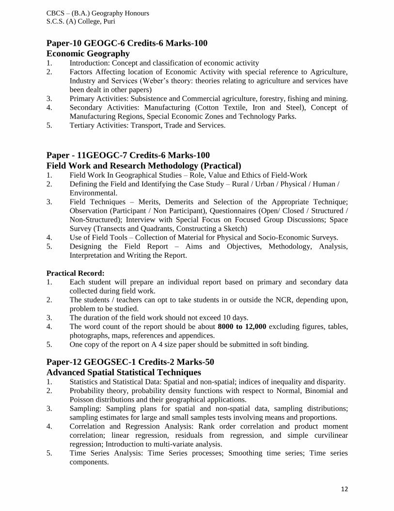
Paper-10 GEOGC-6 Credits-6 Marks-100
Economic Geography 1. Introduction: Concept and classification of economic activity
2. Factors Affecting location of Economic Activity with special reference to Agriculture,
Industry and Services (Weber’s theory: theories relating to agriculture and services have
been dealt in other papers)
3. Primary Activities: Subsistence and Commercial agriculture, forestry, fishing and mining.
4. Secondary Activities: Manufacturing (Cotton Textile, Iron and Steel), Concept of
Manufacturing Regions, Special Economic Zones and Technology Parks.
5. Tertiary Activities: Transport, Trade and Services.
Paper - 11GEOGC-7 Credits-6 Marks-100
Field Work and Research Methodology (Practical) 1. Field Work In Geographical Studies – Role, Value and Ethics of Field-Work
2. Defining the Field and Identifying the Case Study – Rural / Urban / Physical / Human /
Environmental.
3. Field Techniques – Merits, Demerits and Selection of the Appropriate Technique;
Observation (Participant / Non Participant), Questionnaires (Open/ Closed / Structured /
Non-Structured); Interview with Special Focus on Focused Group Discussions; Space
Survey (Transects and Quadrants, Constructing a Sketch)
4. Use of Field Tools – Collection of Material for Physical and Socio-Economic Surveys.
5. Designing the Field Report – Aims and Objectives, Methodology, Analysis,
Interpretation and Writing the Report.
Practical Record:
1. Each student will prepare an individual report based on primary and secondary data
collected during field work.
2. The students / teachers can opt to take students in or outside the NCR, depending upon,
problem to be studied.
3. The duration of the field work should not exceed 10 days.
4. The word count of the report should be about 8000 to 12,000 excluding figures, tables,
photographs, maps, references and appendices.
5. One copy of the report on A 4 size paper should be submitted in soft binding.
Paper-12 GEOGSEC-1 Credits-2 Marks-50
Advanced Spatial Statistical Techniques 1. Statistics and Statistical Data: Spatial and non-spatial; indices of inequality and disparity.
2. Probability theory, probability density functions with respect to Normal, Binomial and
Poisson distributions and their geographical applications.
3. Sampling: Sampling plans for spatial and non-spatial data, sampling distributions;
sampling estimates for large and small samples tests involving means and proportions.
4. Correlation and Regression Analysis: Rank order correlation and product moment
correlation; linear regression, residuals from regression, and simple curvilinear
regression; Introduction to multi-variate analysis.
5. Time Series Analysis: Time Series processes; Smoothing time series; Time series
components.
CBCS – (B.A.) Geography Honours
S.C.S. (A) College, Puri
13
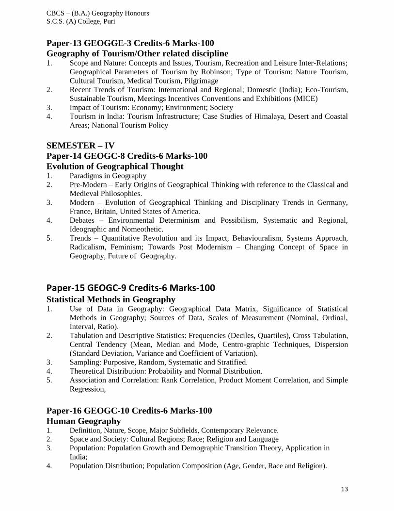
Paper-13 GEOGGE-3 Credits-6 Marks-100
Geography of Tourism/Other related discipline 1. Scope and Nature: Concepts and Issues, Tourism, Recreation and Leisure Inter-Relations;
Geographical Parameters of Tourism by Robinson; Type of Tourism: Nature Tourism,
Cultural Tourism, Medical Tourism, Pilgrimage
2. Recent Trends of Tourism: International and Regional; Domestic (India); Eco-Tourism,
Sustainable Tourism, Meetings Incentives Conventions and Exhibitions (MICE)
3. Impact of Tourism: Economy; Environment; Society
4. Tourism in India: Tourism Infrastructure; Case Studies of Himalaya, Desert and Coastal
Areas; National Tourism Policy
SEMESTER – IV
Paper-14 GEOGC-8 Credits-6 Marks-100
Evolution of Geographical Thought 1. Paradigms in Geography
2. Pre-Modern – Early Origins of Geographical Thinking with reference to the Classical and
Medieval Philosophies.
3. Modern – Evolution of Geographical Thinking and Disciplinary Trends in Germany,
France, Britain, United States of America.
4. Debates – Environmental Determinism and Possibilism, Systematic and Regional,
Ideographic and Nomeothetic.
5. Trends – Quantitative Revolution and its Impact, Behaviouralism, Systems Approach,
Radicalism, Feminism; Towards Post Modernism – Changing Concept of Space in
Geography, Future of Geography.
Paper-15 GEOGC-9 Credits-6 Marks-100 Statistical Methods in Geography 1. Use of Data in Geography: Geographical Data Matrix, Significance of Statistical
Methods in Geography; Sources of Data, Scales of Measurement (Nominal, Ordinal,
Interval, Ratio).
2. Tabulation and Descriptive Statistics: Frequencies (Deciles, Quartiles), Cross Tabulation,
Central Tendency (Mean, Median and Mode, Centro-graphic Techniques, Dispersion
(Standard Deviation, Variance and Coefficient of Variation).
3. Sampling: Purposive, Random, Systematic and Stratified.
4. Theoretical Distribution: Probability and Normal Distribution.
5. Association and Correlation: Rank Correlation, Product Moment Correlation, and Simple
Regression,
Paper-16 GEOGC-10 Credits-6 Marks-100
Human Geography 1. Definition, Nature, Scope, Major Subfields, Contemporary Relevance.
2. Space and Society: Cultural Regions; Race; Religion and Language
3. Population: Population Growth and Demographic Transition Theory, Application in
India;
4. Population Distribution; Population Composition (Age, Gender, Race and Religion).
CBCS – (B.A.) Geography Honours
S.C.S. (A) College, Puri
14
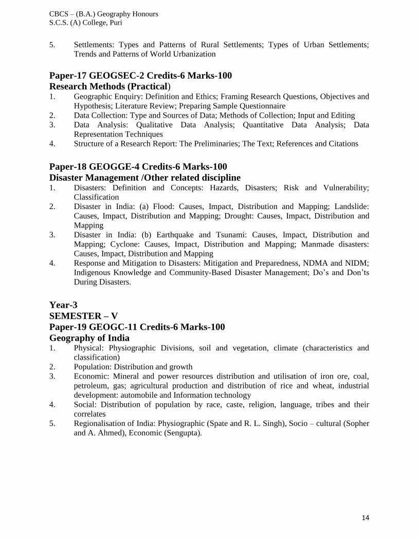
5. Settlements: Types and Patterns of Rural Settlements; Types of Urban Settlements;
Trends and Patterns of World Urbanization
Paper-17 GEOGSEC-2 Credits-6 Marks-100
Research Methods (Practical) 1. Geographic Enquiry: Definition and Ethics; Framing Research Questions, Objectives and
Hypothesis; Literature Review; Preparing Sample Questionnaire
2. Data Collection: Type and Sources of Data; Methods of Collection; Input and Editing
3. Data Analysis: Qualitative Data Analysis; Quantitative Data Analysis; Data
Representation Techniques
4. Structure of a Research Report: The Preliminaries; The Text; References and Citations
Paper-18 GEOGGE-4 Credits-6 Marks-100
Disaster Management /Other related discipline 1. Disasters: Definition and Concepts: Hazards, Disasters; Risk and Vulnerability;
Classification
2. Disaster in India: (a) Flood: Causes, Impact, Distribution and Mapping; Landslide:
Causes, Impact, Distribution and Mapping; Drought: Causes, Impact, Distribution and
Mapping
3. Disaster in India: (b) Earthquake and Tsunami: Causes, Impact, Distribution and
Mapping; Cyclone: Causes, Impact, Distribution and Mapping; Manmade disasters:
Causes, Impact, Distribution and Mapping
4. Response and Mitigation to Disasters: Mitigation and Preparedness, NDMA and NIDM;
Indigenous Knowledge and Community-Based Disaster Management; Do’s and Don’ts
During Disasters.
Year-3
SEMESTER – V
Paper-19 GEOGC-11 Credits-6 Marks-100
Geography of India 1. Physical: Physiographic Divisions, soil and vegetation, climate (characteristics and
classification)
2. Population: Distribution and growth
3. Economic: Mineral and power resources distribution and utilisation of iron ore, coal,
petroleum, gas; agricultural production and distribution of rice and wheat, industrial
development: automobile and Information technology
4. Social: Distribution of population by race, caste, religion, language, tribes and their
correlates
5. Regionalisation of India: Physiographic (Spate and R. L. Singh), Socio – cultural (Sopher
and A. Ahmed), Economic (Sengupta).
CBCS – (B.A.) Geography Honours
S.C.S. (A) College, Puri
15
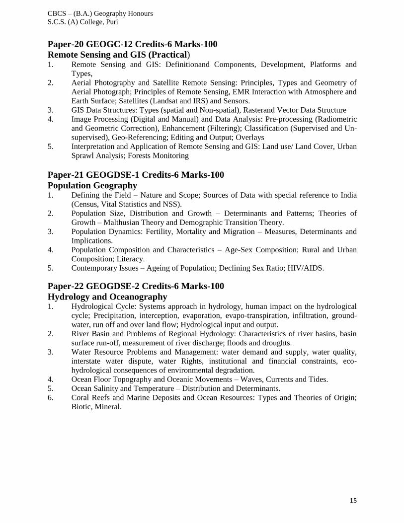
Paper-20 GEOGC-12 Credits-6 Marks-100
Remote Sensing and GIS (Practical) 1. Remote Sensing and GIS: Definitionand Components, Development, Platforms and
Types,
2. Aerial Photography and Satellite Remote Sensing: Principles, Types and Geometry of
Aerial Photograph; Principles of Remote Sensing, EMR Interaction with Atmosphere and
Earth Surface; Satellites (Landsat and IRS) and Sensors.
3. GIS Data Structures: Types (spatial and Non-spatial), Rasterand Vector Data Structure
4. Image Processing (Digital and Manual) and Data Analysis: Pre-processing (Radiometric
and Geometric Correction), Enhancement (Filtering); Classification (Supervised and Un-
supervised), Geo-Referencing; Editing and Output; Overlays
5. Interpretation and Application of Remote Sensing and GIS: Land use/ Land Cover, Urban
Sprawl Analysis; Forests Monitoring
Paper-21 GEOGDSE-1 Credits-6 Marks-100
Population Geography 1. Defining the Field – Nature and Scope; Sources of Data with special reference to India
(Census, Vital Statistics and NSS).
2. Population Size, Distribution and Growth – Determinants and Patterns; Theories of
Growth – Malthusian Theory and Demographic Transition Theory.
3. Population Dynamics: Fertility, Mortality and Migration – Measures, Determinants and
Implications.
4. Population Composition and Characteristics – Age-Sex Composition; Rural and Urban
Composition; Literacy.
5. Contemporary Issues – Ageing of Population; Declining Sex Ratio; HIV/AIDS.
Paper-22 GEOGDSE-2 Credits-6 Marks-100
Hydrology and Oceanography 1. Hydrological Cycle: Systems approach in hydrology, human impact on the hydrological
cycle; Precipitation, interception, evaporation, evapo-transpiration, infiltration, ground-
water, run off and over land flow; Hydrological input and output.
2. River Basin and Problems of Regional Hydrology: Characteristics of river basins, basin
surface run-off, measurement of river discharge; floods and droughts.
3. Water Resource Problems and Management: water demand and supply, water quality,
interstate water dispute, water Rights, institutional and financial constraints, eco-
hydrological consequences of environmental degradation.
4. Ocean Floor Topography and Oceanic Movements – Waves, Currents and Tides.
5. Ocean Salinity and Temperature – Distribution and Determinants.
6. Coral Reefs and Marine Deposits and Ocean Resources: Types and Theories of Origin;
Biotic, Mineral.
CBCS – (B.A.) Geography Honours
S.C.S. (A) College, Puri
16
SEMESTER – VI
Paper-23 GEOGC-13 Credits-6 Marks-100
Regional Planning and Development
1. Definition of Region, Evolution and Types of Regional planning: Formal, Functional, and
Planning Regions and Regional Planning; Need for Regional Planning; Types of regional
Planning.
2. Choice of a Region for Planning: Characteristics of an Ideal Planning Region;
Delineation of Planning Region; Regionalization of India for Planning (Agro Ecological
Zones)
3. Theories and Models for Regional Planning: Growth Pole Model of Perroux; Growth
Centre Model in Indian Context; Myrdal, Hirschman, Rostow and Friedmann; Village
Cluster
4. Changing Concept of Development, Concept of underdevelopment; Efficiency-Equity
Debate
5. Measuring development: Indicators (Economic, Social and Environmenta)l
6. Global Pattern of Development: inter-regional variations; Human development:
International, interstate comparison of India.
Paper-24 GEOGC-14 Credits-6 Marks-100
Disaster Management based Project Work (Practical) The Project work Report based on any two field based case studies among following disasters
and one disaster preparedness plan of respective college or locality:
1. Flood
2. Drought
3. Cyclone
4. Earthquake
5. Landslides
6. Human Induced Disasters: Fire Hazards, Chemical, Industrial accidents
Paper-25 GEOGDSE-3 Credits-6 Marks-100
Urban Geography
1. Urban geography: Introduction, nature and scope; history of urbanisation
2. Patterns of Urbanisation in developed and developing countries
3. Functional classification of cities: Quantitative and Qualitative Methods
4. Urban Issues: problems of housing, slums, civic amenities (water and transport)
5. Case studies of Delhi, Mumbai, Kolkata and Chennai with reference to Urban Issues
CBCS – (B.A.) Geography Honours
S.C.S. (A) College, Puri
17
Paper-26 GEOGDSE-4 Credits-6 Marks-100
Project Report
Introducing Research Component in Under-Graduate Courses
Project work/Dissertation is considered as a special course involving application of knowledge
in solving / analyzing /exploring a real life situation / difficult problem. A Project/Dissertation
work would be of 6 credits. A Project/Dissertation work may be given in lieu of a discipline
specific elective paper.
For papers with practical: Theory-75 marks (Mid sem 15 +End sem 60), practical- 25 (End
sem)
There will be no mid semester exam for practical papers.
For papers with no practical: 100 marks paper = 20 (Midsem) + 80 (End sem)
50 marks paper = 10 (Mid sem) + 40 (End sem)
Subjects with practical: Each of the 14 Core Courses ,4 Discipline Specific Elective Courses
and 4 Generic Elective papers (100 marks each) will have minimum 40 theory classes of 1 hour
duration and minimum of 10 tutorial classes (Normally practical classes at Hons level are of 2
hours duration each)
Subjects without practicals: Each of the 14 Core Courses, 4 Discipline Specific Elective
Courses and 4 Generic Elective papers (100 marks each) will have minimum 50 theory classes
of 1 hour duration and minimum 10 tutorial classes .Ability enhancement (compulsory) and 2
ability enhancement (skill based) papers will have minimum 20 classes each of one hour
duration.
Core Course – CC,
Ability Enhancement Compulsory Course – AECC,
Skill Enhancement Course – SEC,
Discipline Specific Elective – DSE,
Generic Elective – GE,