Embed Size (px)
Citation preview
7/18/2019 Geography 2011-2012.pdf
http://slidepdf.com/reader/full/geography-2011-2012pdf 1/10
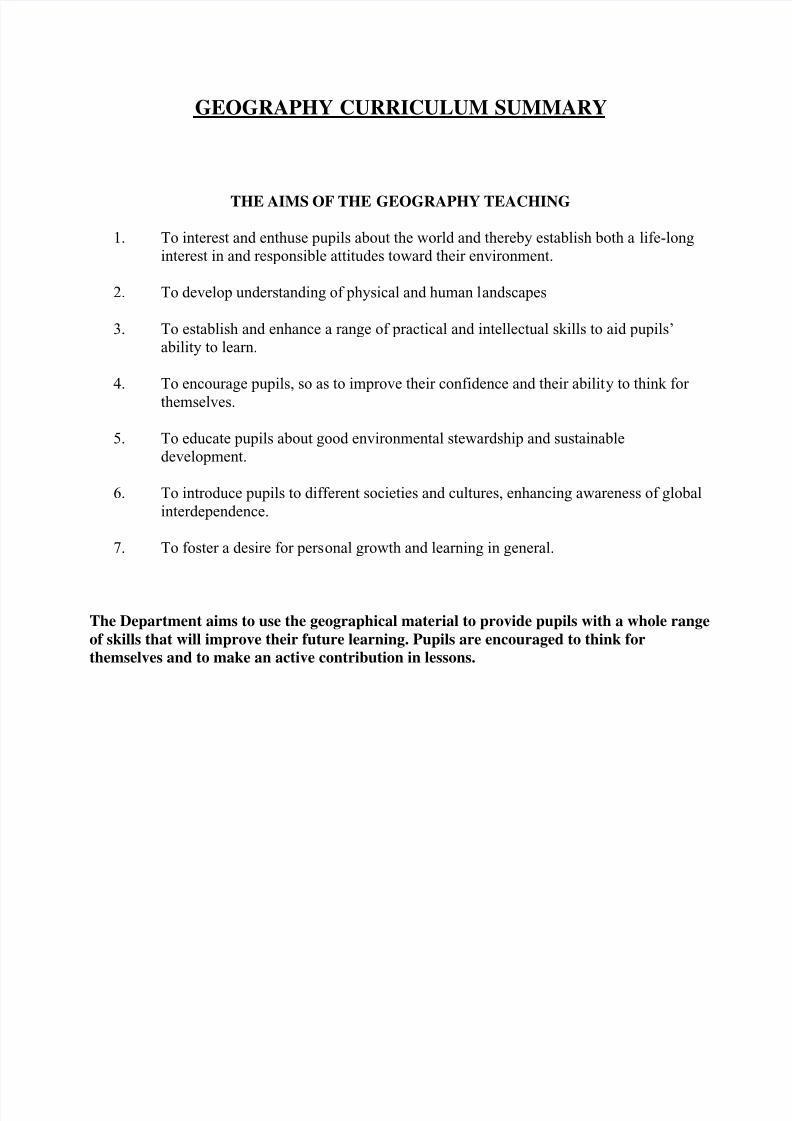
GEOGRAPHY CURRICULUM SUMMARY
THE AIMS OF THE GEOGRAPHY TEACHING
1. To interest and enthuse pupils about the world and thereby establish both a life-long
interest in and responsible attitudes toward their environment.
2.
To develop understanding of physical and human landscapes
3. To establish and enhance a range of practical and intellectual skills to aid pupils’
ability to learn.
4. To encourage pupils, so as to improve their confidence and their ability to think for
themselves.
5. To educate pupils about good environmental stewardship and sustainable
development.
6.
To introduce pupils to different societies and cultures, enhancing awareness of global
interdependence.
7. To foster a desire for personal growth and learning in general.
The Department aims to use the geographical material to provide pupils with a whole range
of skills that will improve their future learning. Pupils are encouraged to think for
themselves and to make an active contribution in lessons.
7/18/2019 Geography 2011-2012.pdf
http://slidepdf.com/reader/full/geography-2011-2012pdf 2/10
YEAR 5 GEOGRAPHY
PERIODS: 2 x 35 mins. PREP: 1 x 35 mins. (every fortnight).
Year 5 work establishes a basic grounding in the subject, focusing largely on global location.
The work is based on the National Curriculum Geography Programmes of Study:
Geographical Skills
Places
Thematic Study
CONTINENTS AND OCEANS:
a) How the world is divided.
Name the 7 continents (on world map) and the capital of each.
How the continents are broken down.
e.g. British Islescountriescountiescitiestownsvillages, etc.
Name the 5 oceans (on world map).
Recognise the shape of continents out of context.
Time differences.
MAPPING AND DEFINING LOCAL AREA:
a) Draw a simple map of how to find one’s way to school from home or vice versa,
looking out for landmarks. Direction. Read distance on car’s milometer.
b) Locate own village on O.S. map and mark it.
c) Where do most of the children travel from?
d) By using wool, measure the distance travelled (as the crow flies) and change to kms. by
using the scale of the map.
e) Who travels the furthest? How does it differ from the mileage recorded in the car?
Why?f) Why do settlements vary in size?
g)
Should streets be closed to traffic? Why? Why not?
h) The problems involved in g).
United Kingdom:
a) Using a map of UK, locate the features named by the National Curriculum:
Countries of UK; cities; upland areas; rivers; seas; locate Kent in relation to UK.
b) Map of Kent showing neighbouring villages and consideration of geology and
physical features.
7/18/2019 Geography 2011-2012.pdf
http://slidepdf.com/reader/full/geography-2011-2012pdf 3/10
Europe:
a) Using a map of Europe, locate the features named by the National Curriculum.
b) Select an EU country and discover the population, area, monetary system, language,
flag, longest river, highest mountain. Conduct own investigation into areas such as food
and culture.
ORDNANCE SURVEY WORK:
a) Introduce O.S. work.
b) Grid references (4-figure): how do you do these? Direction, distance, height.
Aerial photos.
Draw grid and try examples with crosses.
c) Select a picture, draw a grid over it, and mark certain spots.
d) Introduce O.S. symbols. Learn common ones. Learn about direction, distance, height.
e) Use an O.S. map to recognise the symbols, and read grid references.f) Direction: worksheets, field-work on site.
g) Identify features on a large-scale map and on a vertical, aerial photograph of the same
place.
THE WORLD:
a) To learn about the world. What shape is it?
b) It rotates twice. How? In rotating what do we experience?
c) The equator is the most important line of latitude. What does it separate?
Differences between these two hemispheres.
d) The Prime Meridian is the most important line of longitude.
Separates Western/Eastern hemisphere and is the base for the International Time Zone
System. Visit to Greenwich Maritime Museum.
e) Become familiar with an atlas.
f) Be able to use the index and contents pages to find information in the atlas.
g)
Reason for physical/political maps.
h) Grid references.
How people would travel around the world.
The use of faxes, e-mail, letters to connect people around the world.
WATER:
a)
To recognise water features on an OS map
b) Where fresh water would be found in local area, and the need for it.
c) Locate main desert areas in the world.
d) Look briefly at world weather patterns.
e) Transportation of water.
f) Uses of water.
g)
Investigation of permeability with reference to the 3 rock types and use of the school site.
7/18/2019 Geography 2011-2012.pdf
http://slidepdf.com/reader/full/geography-2011-2012pdf 4/10
YEAR 6 GEOGRAPHY
PERIODS: 2.5 x 35 mins. PREP: 1 x 30 mins.
The work is based on the National Curriculum Geography Programmes of Study:
Geographical Skills
Places
Thematic Study
Year 6 begins with an appreciation that geographers are primarily interested in space. Pupils are
introduced to the basic underlying concepts of LOCATION, DISTRIBUTION, SCALE, LINKS
and CHANGE.
The next stage is a detailed consideration of ‘place’. Pupils are encouraged to question why
places are as they are (and not a different way)? Human Geography is traced to its physical roots.
The links between different aspects of environments are emphasised.
The investigation of links leads to a consideration of animal and plant adaptations in different
biomes, including mountains, savannah and tropical rainforests. Human lifestyles and their
impact are studied as an integral part of these environments.
Pupils also learn map skills and some introductory material about rivers, in preparation for Year
7. There is a field visit to a local river to study cross-sectional profiles and flow characteristics.
THE WORLD/ATLAS:
a) Reinforcement of global locations:
Great Britain – Map D National Curriculum.
Europe – Map B National Curriculum.
b) Name features marked on Map C World as named in the National Curriculum.
c)
Look at routes around the world – important features that might be seen from the
air / sea.
ORDNANCE SURVEY WORK:
a) Symbols. Direction and distance.
b) Use six-figure grid references to locate features on O.S.map.
Select a picture, draw a grid over it, and mark certain spots.
Lots of reinforcement work using photocopiable work and O.S. maps.
c) Interpret relief maps - look at height of land. What do contour lines show?
Why should
certain things, e.g. viewpoint, be positioned as they are?
7/18/2019 Geography 2011-2012.pdf
http://slidepdf.com/reader/full/geography-2011-2012pdf 5/10
d) Follow a route on a 1:50,000 O.S. map and describe features seen - look at both sides of
road.
e) Communication-lines on OS maps.
f) Aerial photographs.
g) Look at direction travelling.
h) Measure the straight-line distance between two points on a map and convert to km.
RIVER SYSTEMS:
a) Simple knowledge of where a river begins and ends.
b) Identifying the parts of a river system on a simple diagram.
c) Evidence that materials are eroded, transported and deposited.
d) Explain causes and effects of river floods, and how they can be reduced.
e) Visit a river to see the features.
f) Locate major rivers around the world.
g) What are rivers used for?
THE ENVIRONMENT:
a) An investigation of systems theory in general and eco-systems in particular.
b)
Study of a mountain environment with particular reference to climate, homes and life-
styles.
c) Environmental damage and how it can occur.
d) How can pollution be reduced and damaged landscapes be restored?
CLIMATIC ZONES (Savannah and Rain Forest Regions):
a) Different climates - where might these occur and why?
b) Location of these zones on a world map.
c) Climates compared: differences between lifestyle and vegetation.
INVESTIGATION OF AN UNDERDEVELOPED COUNTRY (contrasting environment):
a)
Links to the world. b)
What would it be like to live there?
c) Compare with home region: similarities and differences.
d)
Is the country changing? How? Why?
7/18/2019 Geography 2011-2012.pdf
http://slidepdf.com/reader/full/geography-2011-2012pdf 6/10
YEAR 7 GEOGRAPHY
THIS IS THE FIRST YEAR OF A TWO-YEAR COURSE.
PERIODS: 2.5 x 35 mins. PREP: 1 x 30 mins.
COURSE-BOOK: "Geography For Common Entrance” (Widdowson) (Pub. John Murray.)
Also recommended: "GCSE Geography - The Revision Guide"(Published by Co-ordination Group Publications. ISBN: 1 84146 7006)
“ISEB Revision Guide Geography”Belinda Froud. ISBN: 978-0-90362-749-8
The work is based on the National Curriculum Geography Programmes of Study.
Geographical Skills
Places
Thematic Studies
In Years 7 and 8 pupils follow the Common Entrance Syllabus, but topics are taught at a higher
level than that which is actually examined. More able pupils are required to write essays to fairly
open questions. We aim to give Scholarship candidates some kind of theoretical underpinning to
help structure their ideas, e.g. a simple model or diagram against which to view located examples.
Year 7 is mainly Physical Geography, with the human aspects receiving greater emphasis in Year
8.
Pupils are encouraged to broaden their horizons by reading, or by watching television
programmes relating to other parts of the world, or which concern general world issues. Every
journey (by rail, sea, air or road) is a potential Geography lesson.
ORDNANCE SURVEY MAPWORK (taught throughout the course)
Scale 1:25 000 and 1:50 000 map extracts. Physical features
Scale/direction/symbols Relief
4+6 figure references Simple cross-sections
Orientation Distance
Area Following routes
Activities
Cross sections; "walks" and "cycle rides" across extracts; spending a holiday in an area; analysis
of settlement growth (refer to earlier maps); location of various industries; how relief affectscommunication.
7/18/2019 Geography 2011-2012.pdf
http://slidepdf.com/reader/full/geography-2011-2012pdf 7/10
GLOBAL LOCATION: YEARS 7 AND 8.
North and South America Time Zones
Africa Political groupings (EU etc.)
Australasia Latitude and longitude revisionEurope British Isles
AUTUMN TERM: TECTONIC PROCESSES:
• The structure of the Earth
• Earthquakes, volcanoes, plate tectonics
• Sedimentary, igneous and metamorphic rocks
• The rock cycle
• The water cycle
•
Tectonic processes - case studies: the Asian tsunami and New Zealand earthquakes
SPRING TERM: GEOMORPHOLOGICAL PROCESSES:
• Processes, e.g. weathering, erosion, transportation, deposition, responsible for the
development of selected landforms including the role of rock-type
• Examples of landforms that have been caused by these processes in fluvial and coastalenvironments
• Processes (tectonic, geomorphological or human) causing landslides and the effect of
these on people
Case Study: Floods – Boscastle and the River Exe (North Cornwall). (Also Felixstowe)
SUMMER TERM: WEATHER AND CLIMATE:
• Differences between either and climate on a local and national scale, including micro-
climates
• Types of rainfall: relief, frontal and convectional
• Causes of temperature and rainfall variation from place to place in the British Isles
Case Study: A weather/climate hazard - Hurricane Katrina
7/18/2019 Geography 2011-2012.pdf
http://slidepdf.com/reader/full/geography-2011-2012pdf 8/10
YEAR 8 GEOGRAPHY
PERIODS: 2.5 x 35 mins. PREP: 1 x 30 mins.
COURSE-BOOK: "Geography For Common Entrance” (Widdowson)
(Pub. John Murray: ISBN 9 7807 19 575723)
Also recommended: "GCSE Geography: The Revision Guide"
“ISEB Revision Guide Geography”Belinda Froud. ISBN: 978-0-90362-749-8
The work is based on the National Curriculum Geography Programmes of Study:
Geographical SkillsPlaces
Thematic Study
The syllabus is based on the Common Entrance Examination and the National Curriculum
(Key Stage 3).
In Year 8, pupils follow the second part of the Common Entrance Syllabus, but topics are taught
at a higher level than that which is actually examined. More-able pupils are required to write
essays to fairly-open questions. We aim to give Scholarship candidates some kind of theoretical
underpinning to help structure their ideas, e.g. a simple model or diagram against which to view
located examples.
Year 8 is mainly about Human Geography.
GLOBAL LOCATION: (taught throughout the course):
North and South America Time Zones
Africa Political groupings (EU etc.)
Australasia Latitude and longitude revision
Europe British Isles
AUTUMN TERM: FELIXSTOWE FIELDWORK AND TECTONIC PROCESSES:
Felixstowe Fieldwork:
• Preparation
•
The geographical context• The location of Felixstowe
7/18/2019 Geography 2011-2012.pdf
http://slidepdf.com/reader/full/geography-2011-2012pdf 9/10
• Historical, land and sea factors affecting the threat from the sea
A fieldwork investigation (worth 20% of the final Common Entrance / Year 8 exam-mark) will
be completed in the first term of Year 8. Much personal organisation is required as pupils have a
fixed deadline by which to complete the work. C.E. candidates have details of their work sent totheir future schools.
Fieldwork involves much cross-curricular work, the gathering of information and its presentation
in maps/diagrams/graphs, the use of computers, hypothesising, interpretation and drawing of
conclusions, etc. Currently we study coastal erosion at Felixstowe in Suffolk.
Pupils are encouraged to broaden their horizons by reading, or by watching television
programmes relating to other parts of the world, or which concern general world issues. Every
journey (by rail, sea, air or road) is a potential Geography lesson.
SPRING TERM: ECONOMIC ACTIVITY:
The differences between Primary, Secondary and Tertiary activities; the geographical distribution
of two types of contrasting economic activities from different sectors; how and why the
distribution has changed and is changing, and the effects of such changes.
• Classification of economic activity, with examples of each
• Recognition of location factors relating to primary, secondary, tertiary, and quaternaryactivities on an OS map.
CASE STUDY: A GLOBAL ECONOMIC ACTIVITY:
• Nike (Vietnam)
• Farming in East Anglia
• Tourism in Palau, Micronesia
• The sherpas of Nepal
SUMMER TERM: ENVIRONMENTAL ISSUES
Areas of great scenic attraction; conflicting demands made on such areas and issues that arise; the
attempts made to plan and manage such environments and how these may have unintended
effects; how considerations of sustainable development, stewardship and conservation may affect
environmental planning and management.
• Location of the National Parks in the British Isles
• Reasons for conflicting demands on an environment (i.e. agriculture, conservation,derelict land, forestry, industry, landfill, military, pollution, power, reservoirs, tourism,
transport, urbanisation) and their effect on people.
Case Studies: Dartmoor National Park; the Amazon Rainforest, Felixstowe.

7/18/2019 Geography 2011-2012.pdf
http://slidepdf.com/reader/full/geography-2011-2012pdf 10/10
REVISION OF SYLLABUS TOPICS FOR COMMON ENTRANCE AND ASSESSMENT
The scholarship group moves rather faster than the CE groups as exams are often earlier in the
year and it is wise to try to cover more of the syllabus options.