Embed Size (px)
Citation preview
Year 2016 Papers, 1, 2, & 3
st09n BGCSESchool Number Candidate Numtrer
Surname and Initials
I
--II
-I
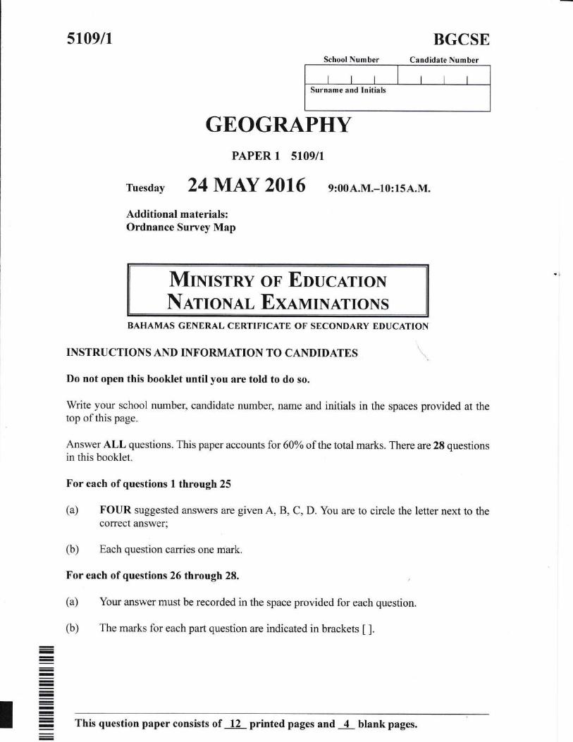
GEOGRAPHYPAPER 1 5109/I
ruesday 24 M.AY 2016 e:00A.M.-r0:15A.M.
Additional materials:Ordnance Survey Map
MINIsTRYNauoNAL
OT EUUCATIoNExarvuNATroNS
BAHAMAS GENERAL CERTIFICATE OF SECONDARY EDUCATION
INSTRUCTIONS AND INFORMATION TO CANDIDATES
Do not open this booklet until you are told to do so.
Write your school number, candidate number, name and initials in the spaces provided at thetop of this page.
Answer ALL questions" This papff accounts for 60Yo of the total marks. There are28 questionsin this booklet.
For each ofquestions I through 25
(a) FOUR suggested answers are given A, B, C, D. You are to circle the letter next to thecorrect answer;
(b) Each question carries one mark.
For each of questions 26 through 28.
(a) Your answer must be recorded in the space provided for each question.
(b) The marks for each part question are indicated in brackets [ ].
= This question paper consists of 12 printed pages and 4 blank pages.
.\-L-
Circle the letter which represents the best response.
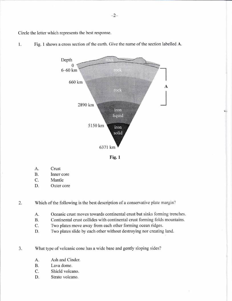
1. Fig. 1 shows a cross section of the earth. Give the name of the section labelled A.
660 km
2890 km
5150 km
6371 km
Fig. I
Depth01
6-60 km IA
l
2. Which of the following is the best description of a conservative plate margin?
A.B.C.
D.
A.B.
C.
D.
CrustInner core
MantleOuter core
Oceanic crust moves towards continental crust but sinks forming trenches.
Continental crust collides with continental crust forming folds mountains.
Two plates move away from each other forming ocean ridges.
Two plates slide by each other without destroying nor creating land.
-). What type of volcanic cone has a wide base and gently sloping sides?
A. Ash and Cinder.
B. Lava dome.
C. Shield volcano.
D. Strato volcano"
-3-
4. What is the lowest layer of the atmosphere called?
A.B.C.
D.
Exosphere.
Inosphere"
Stratosphere.
Troposphere.
Altostratus.Cirrocumulus.Cimrs"Stratus.
5. Which of the following is a low level cloud?
A.B.C.
D.
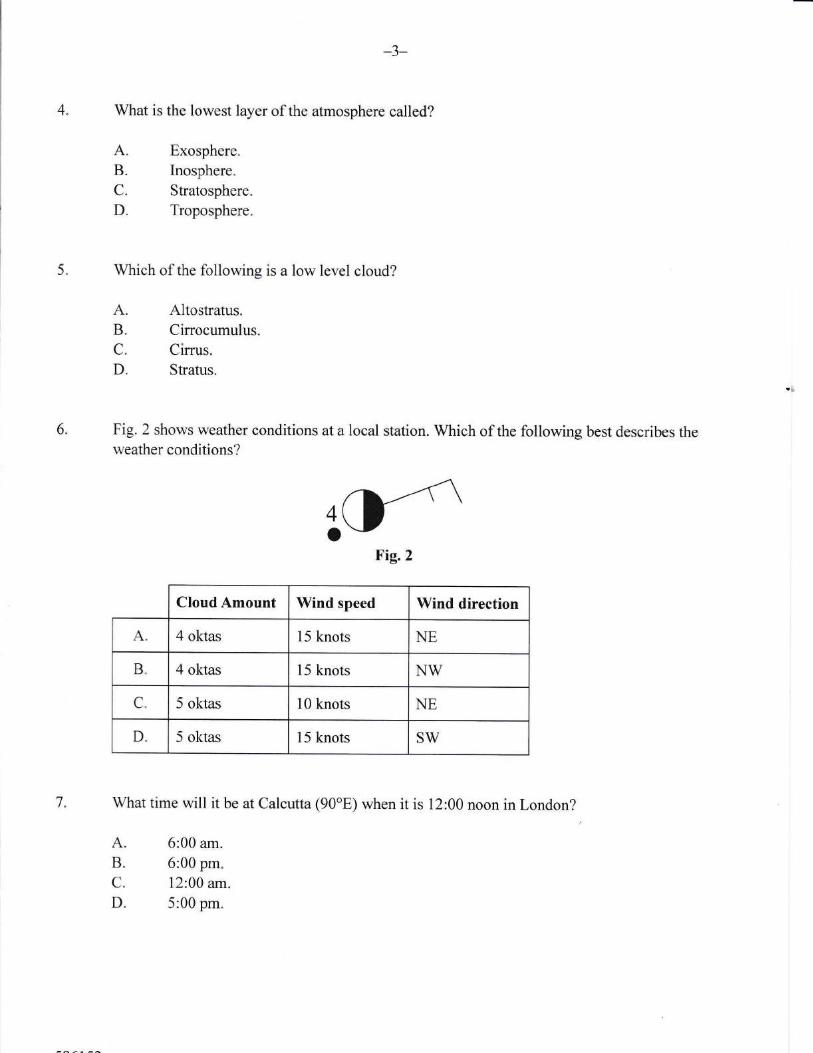
6" Fig.2 shows weather conditions at a local station. Which of the following best describes theweather conditions?
rrFig.2
CloudAmount Wind speed Wind direction
A. 4 oktas 15 knots NE
B. 4 oktas 15 knots NW
C. 5 oktas 10 knots NE
D. 5 oktas 15 knots SW
7. What time will it be at Calcutta (90"E) when it is 12:00 noon in London?
A.B.C.
D"
6:00 am.
6:00 pm.12:00 am.
5:00 pm.
4-
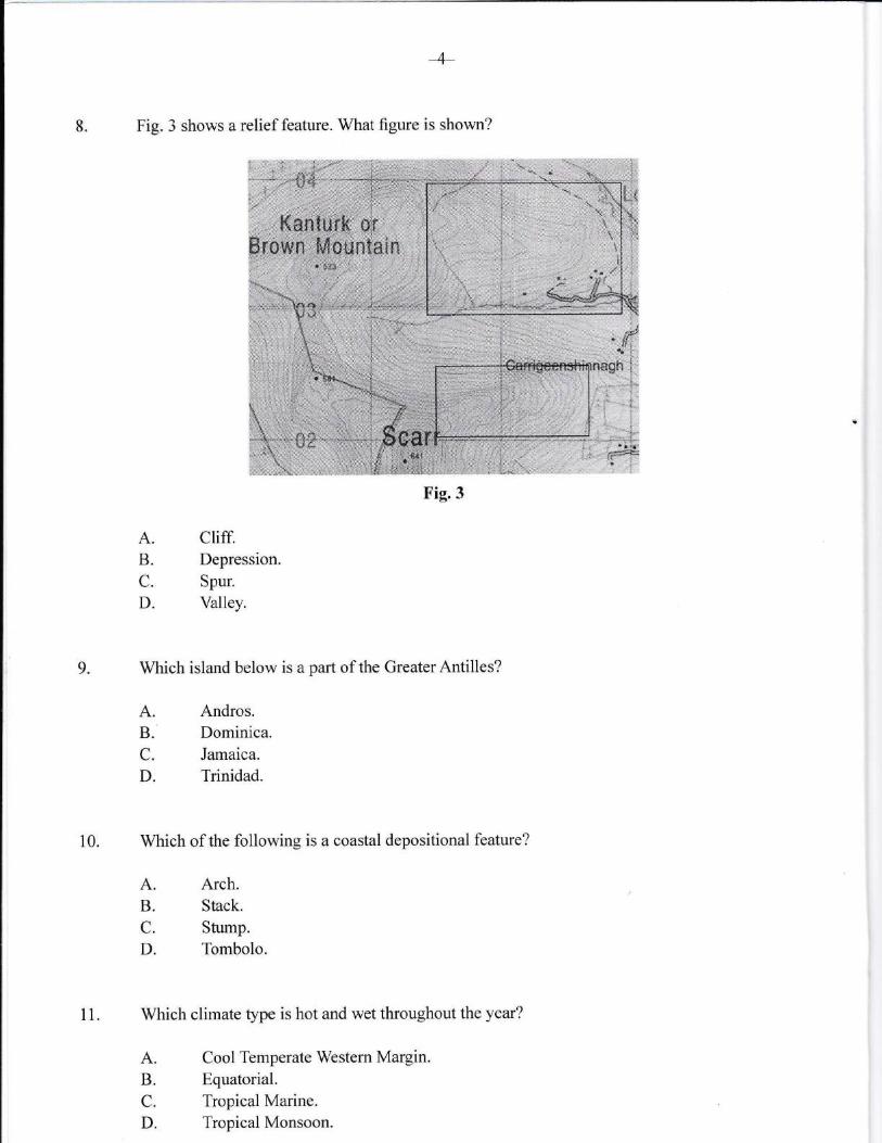
8. Fig. 3 shows a relief feature. What flgure is shown?
A.B.
C.
D.
cliff.Depression.
Spur.
Valley.
Arch.Stack.
Stump.
Tombolo.
9. Which island below is a part of the GreaterAntilles?
A. Andros.B. Dominica.C. Jamaica.
D. Trinidad.
10. Which of the following is a coastal depositional feature?
A.B.C.
D.
Which climate type is hot and wet throughout the year?
A. Cool Temperate Western Margin.
B. Equatorial.C. Tropical Marine.D. Tropical Monsoon.
Fig.3
11.
12"
-5-
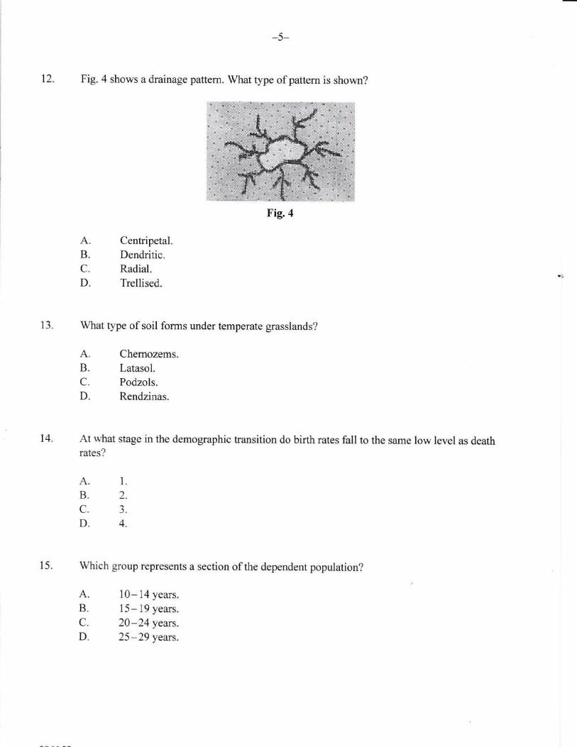
Fig. 4 shows a drainage pattern. What type of pattern is shown?
13. What type of soil forms under temperate grasslands?
A.B.C.
D.
A.B.C.
D.
Centripetal.Dendritic.Radial.Trellised.
Chemozems.
Latasol.Podzols.
Rendzinas.
14. At what stage in the demographic transition do birth rates fall to the same low level as deathrates?
15. Which group represents a section of the dependent population?
A.B.C.
D.
A.B.C.
D.
1.
2.
3.
4.
10- 14 years.
15-19 years.
20-24 years.
25-29 years.
Fig.4
-6-
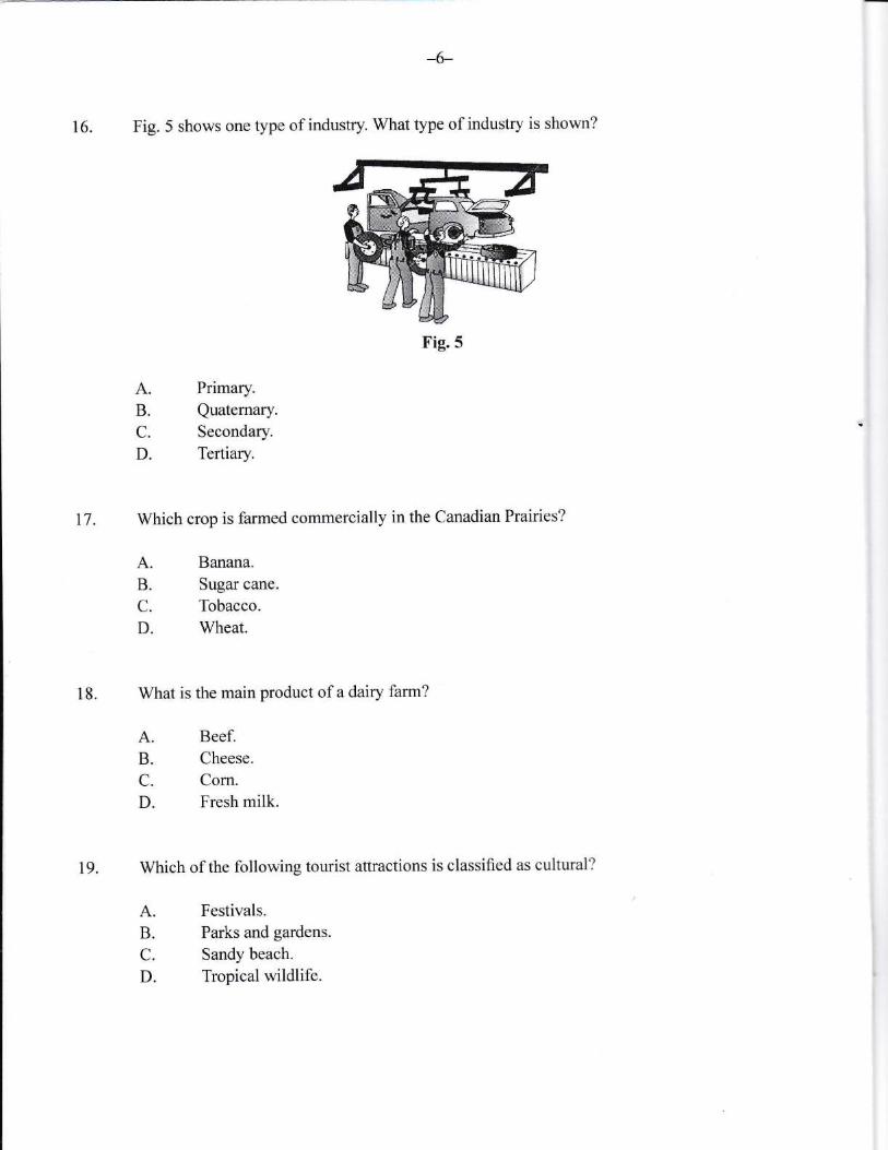
16. Fig. 5 shows one type of industry. What type of industry is shown?
A.B.C.
D.
Primary.
Quaternary.Secondary.
Tertiary.
Banana.
Sugar cane.
Tobacco.
Wheat.
Beef.Cheese.
Corn.Fresh milk.
Festivals.Parks and gardens.
Sandy beach.
Tropical wildlife.
t7. Which crop is farmed commercially in the Canadian Prairies?
A.B.C.
D.
18. What is the main product of a dairy farm?
A.B.C.
D.
19. Which of the following tourist attractions is classified as cultural?
A.B.C.
D.
Fig.5
-7-
20. Which of the following best describes the distance a person is willing to travel for a particularservice?
A. Hierarchy.B. Range"
C. Sphere of influence.D. Threshold.
-8-
Use the enclosed Ordnance Survey map extract of Inagua (The Bahamas) to answer questions2t-26.
21. What is the direction of Mortimer's Hill from the Store Union?
22. What is the height of the highest point north of grid line 18?
A.B.C.
D.
A.B.C.
D.
A.B.
C.
D.
NW.NE.sw.SE.
23. What is the predominant vegetation in lnagua?
18 feet.
23 feet.39 feet.
53 feet.
Casuarina.
Coconut.Mixed Broadleaf Coppice.Whiteland.
24. What is the vertical interval of this map?
A. 5 feet.
B. 10 feet.
C. 15 feet.
D. 20 feet.
25. Which natural feature is not found along the southern coastline?
A. Beach.
B. Cliff.C. Point.D. Coral reef.
l
t
4-
26.. (a) The mining of salt is practiced in Inagua. State THREE ways saltmay be used.
1.
')
aJ.
t3l
(b) Name TWO other industries that the inhabitants of Inagua may take part in.
1.
2. p)
-10-
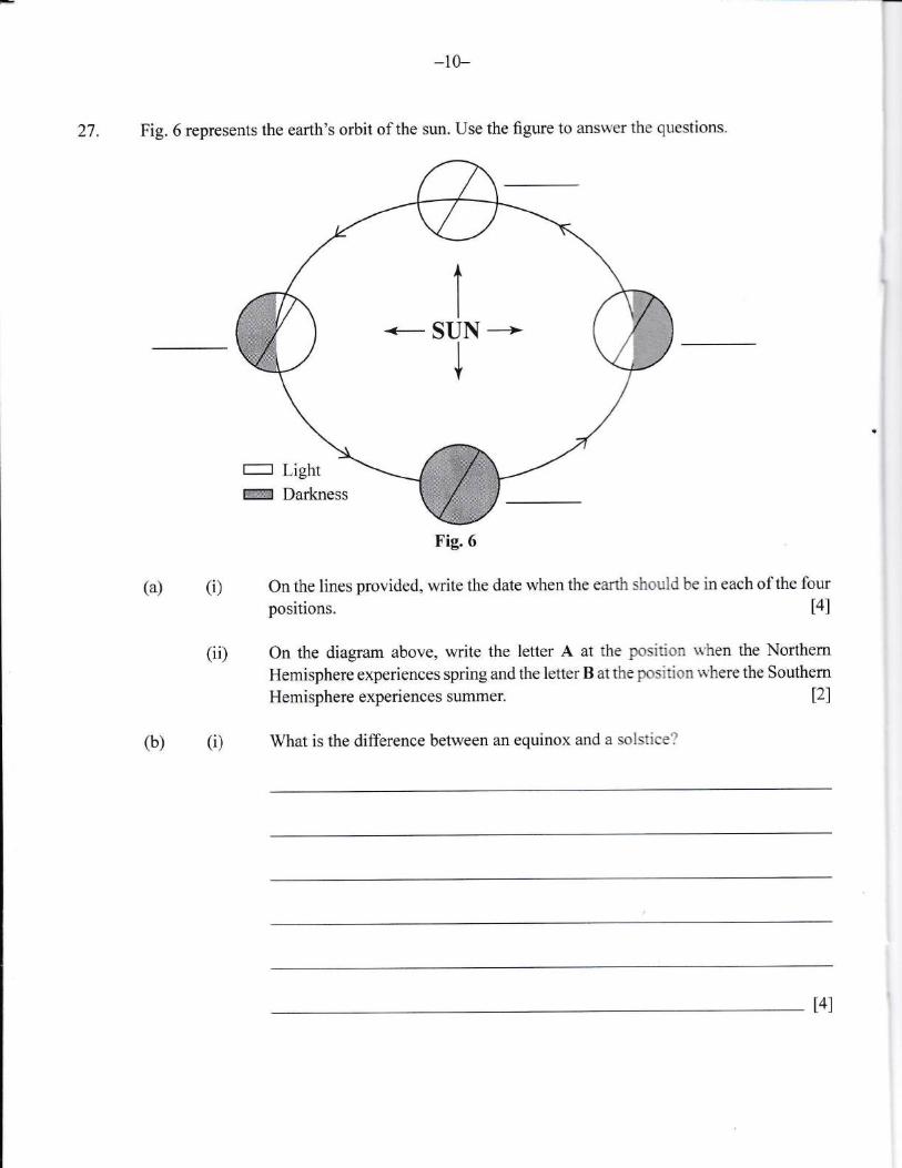
27. Fig. 6 represents the earth's orbit of the sun. Use the figure to answer the questions.
(a) (i) On the lines provided, write the date when the earth should be in each of the four
positions. t4l
(ii) On the diagram above, write the letter A at the position rn'hen the Northern
Hemisphere experiences spring andthe letterB atthepositionwherethe Southern
Hemisphere experiences summer.
(i) What is the difference between an equinox and a solstice?
l2l
(b)
tSUN --i
Fig.6
l4l
-11-
(ii) How does the ear,th's rotation result in different time eorres?
t3l
28. (a)
-12-
(i) Explain THREE reaso-ns why water is important.
1.
2.
3.
(i0
T6I
In the boxes provide{ illustrate,a labelled diagram to show orographic (relief)
and frontal (cyclonic) rainfatl'
(iii) State THREE ways that we catr conservc water
1.
2.
3.
Explain TWO ways that domestic water is obtained in ThE Bahamas.
t.
2.
st09t2 BGCSESchool Number Candidate Number
Surname and Initials
GEOGRAPHYPAPER 2 5IO9/2
ruesday 31 MAY 2016 e:00A.M.-u:30A.M.
Additional materials:Ordnance Survey Map
MrNrsrRYNauoNAL
OT EuUCATIoNExaurNATroNS
BAHAMAS GENERAL CERTIFICATE OF SECONDARY EDUCATION
INSTRUCTIONS TO SUPERVISORS
Candidates should be issued at the start of the examination with the paper for which they havebeen entered EITHER Paper 2 OR Paper 3.
Paper 2 is targeted at those candidates who would be expected to achieve a grade withinthe range C to G.
INSTRUCTIONS AND INFORMATION TO CANDIDATES
Do not open this booklet until you are told to do so.
Write your school number, candidate number, sumame and initials in the spaces provided onthis booklet.
This paper accounts for 50o/o of the total marks. There are 8 questions in this booklet.
Candidates must answer any FOUR questions. If you attempt more than FOUR questions onlythe first FOUR answers will be marked. All questions carry twenty marks. The mark for eachpart-question is given in brackets [ ].
ALL candidates are required to write their answers in the spaces provided for each question.I
I
I
I
I
-=
This question paper consists of 21 printed pages and 3 blank pages.l=
1-L-
Study the map extract of Port Antonio on a scale of 1:50 000 and complete the following exercise.
1. (a) Give the four figure grid reference of the following places.
(i) Egg Hill
(ii) Comfort Castle
(b) Give TWO ways that height is shown on this map.
tll
l1l
1.
2. t2l
(c) (i) What is the drainage pattern along the Rio Grande?
(ii) Desuibe the pattern identified in (cXi).
l1l
t3l
(d) (i) Identify THREE natural features along the northern coast.
t.
2.
-J. t3l
-J-
(ii) Choose TWO features and explain their formation.
1.
2.
t4l
(e) (i) Name THREE services offered by PortAntonio.
1.
2.
J.
(iD Suggest TWO recreational aetivities that the inhabitants of Port Antonio mayenjoy.
1.
t3l
t2I2.
4-
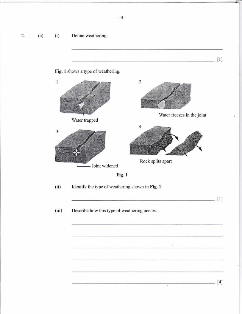
2. (a) (i) Define weathering.
Fig. 1 shows a type of weathering.
Water trapped
I1l
(ii)
Fig. I
Identify the type of weathering shown in Fig. l.
tll
(iii) Describe how this type of weathering occurs.
Water freezes in the joint
Rock splits apartJoint widened
t4l
-5-
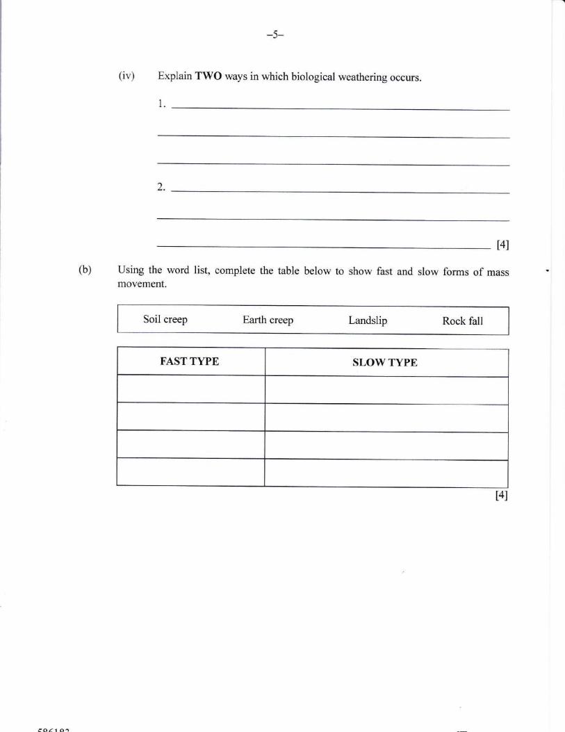
(iv) Explain TWO ways in which biological weathering occurs.
1.
')
t4l
(b) Using the word list, complete the table below to show fast and slow forms of mass ?
movement.
Soil creep Earth creep Landslip Rock fall
FAST TYPE SLOW TYPE
t4l
Describe and e-xplain THREE effects of mass movement on the environment.
1.
''J
(i)(a)aJ.
-7-
Give THREE factors which favour plant growth in the Equatorial Region.
1.
2.
-).
t6l
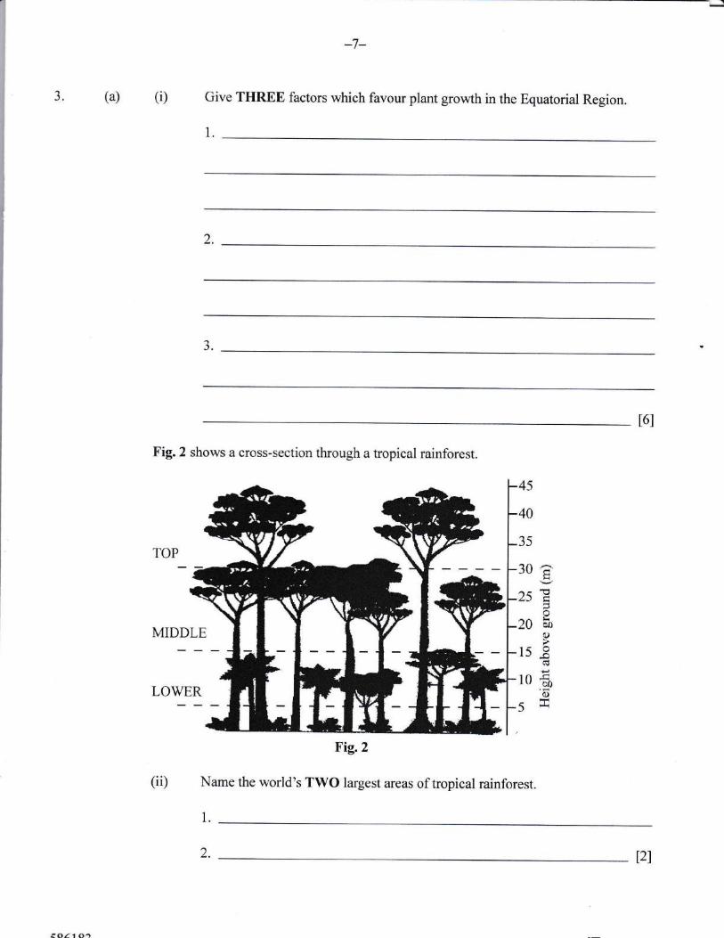
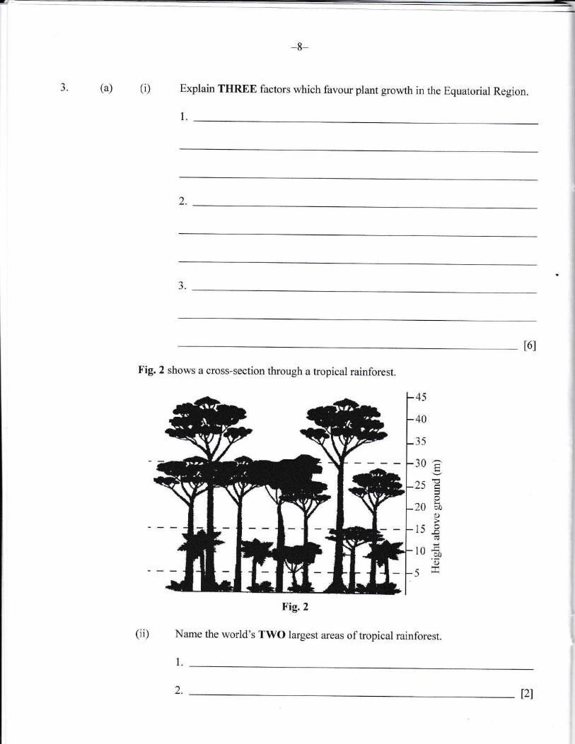
Fig.2 shows a cross-section through a tropical rainforest.
45
40
35
30a2sE
20 50I
lssr-l10fi'6
^5 Frr
Name the world's TWO largest areas of tropical rainforest.
1.
t2l2.
(iii) Describe each layer of the tropical rainforest shown in Fig.2.
TOP
MIDDLE
LOWER
t6l
(b) List TWO species of trees in the rainforest.
1.
)
(c) Explain why the soil in rainforests are relatively infertile.
Ii
t4l
-9-
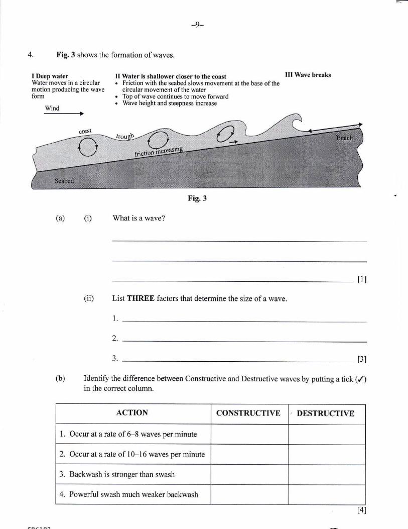
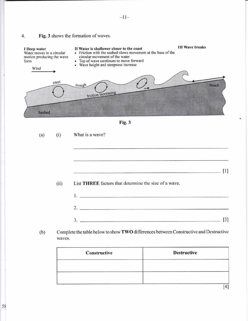
4. Fig.3 shows the formation of waves.
I Deep waterWater moves in a circularmotion producing the waveform
Wind
II Water is shallower closer to the coast. Friction with the seabed slows movement at the base of the
circular movement of the watero Top of wave continues to move forwardo Wave height and steepness increase
III Wave breaks
(a) (i) What is a wave?
t1l
(ii) List THREE factors that determine the size of a wave.
1.
Identify the difference between Constructive and Destructive waves by putting a tick (/)in the correct column.
t3l
2.
aJ.
(b)
ACTION CONSTRUCTIVE DESTRUCTIVE
1. Occur at a rate of 6-8 waves per minute
2. Occur at a rate of 10-16 waves per minute
3. Backwash is stronger than swash
4. Powerful swash much weaker backwash
t4l
*10-
(c) Name and explain TIIREE ways in which wave$ erode.
1.
2.
J.
t5l
(d) It is important to manags eoastal areas. Name and explain TEREE ways that coastal
areas are protected in The Bahamas"
t.
2.
3.
t6l
-l l-
5. F'ig. 4 gives views about forestry expressed by conservation groups.
Every minute, an area of rainforest, the size of 15 football pitches, is destroyed.At the present rate of destruction, in 40 years'time there will be virtually no morerainforest. That means the Earth's climate will change. We will lose a precioussource of medicine. We will be deprived of an important source of food andindustrial products. And we will lose over half the world's animal and plantspecies.
Fig. 4 The New Wder World 2nd Edition blt David Waugh
(a) (i) What term is used for the large scale destruction of forest?
tll r
(ii) List and explain THREE causes of forest destruction.
1.
2.
3.
t6l
*r2-
(iii) Suggest TWO ways that the removal of trees cirn pfove benefioial to a eouotry.
1.
2.
Explaln TIIREE reasons why fores8 and woodlands are to people in the
Caribbean.
t.
2.
3.
(c) Name TIIREE types of forcst found iu the Caribbean.
1.
2.
3.
-13-
6. (a) Define demography.
t1l
(b) How are population statistics obtained in The Bahamas?
t2l
(c) Explain THREE physical factors that influence the distribution of population.
l.
2.
J.
16l
-t4-
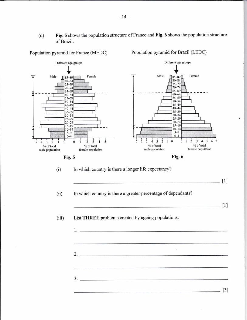
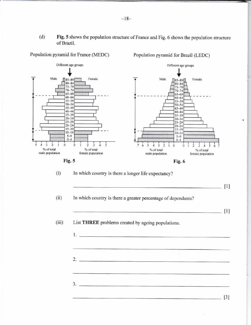
(d) Fig. 5 shows the population sfucture of France and Fig. 6 shows the population structure
of Brazil.
Population pyramid for France (MEDC) Population pyramid for Brazil (LEDC)
Diflerent age goups
+
I
Different age goups
s43210012345g6oftotal %oftotal
male population female population
Fig.5
6 5 4 3 2 | 0 0l 2 3 4 5 61%oftotal ?Loftotal
male population femde PoPulation
Frg.6
(r) In which country is there a longer life expectancy?
(ii) In which country is there a greater percentage of dependants?
(iii) List TI{REE problems created by ageing populations.
l.
t1l
tll
+8H980-8475-1970-7465-69M55-5950-54454940-4435-39
24l5-l
.,
J.
t3l
-15-
(iv) List TWO stmtegies for increasing population in MEDCs.
1.
2,
t2I
(e) Explain TWO strategies for reducing population gro$/th in LEDCs.
1.
)
t4l
-17-
(ii) state THREE reasons that may have caused each type of migration to occur.
Voluntary: 1.
2.
J.
Forced: 1.
2.
aJ.
t6l
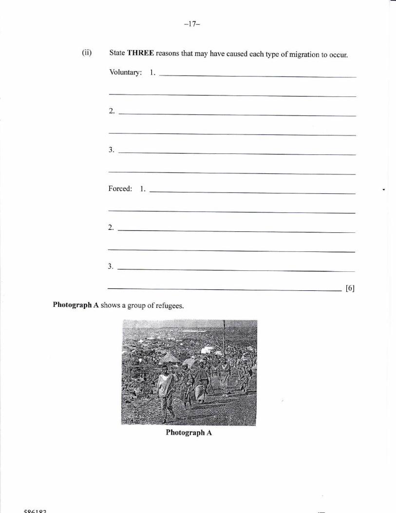
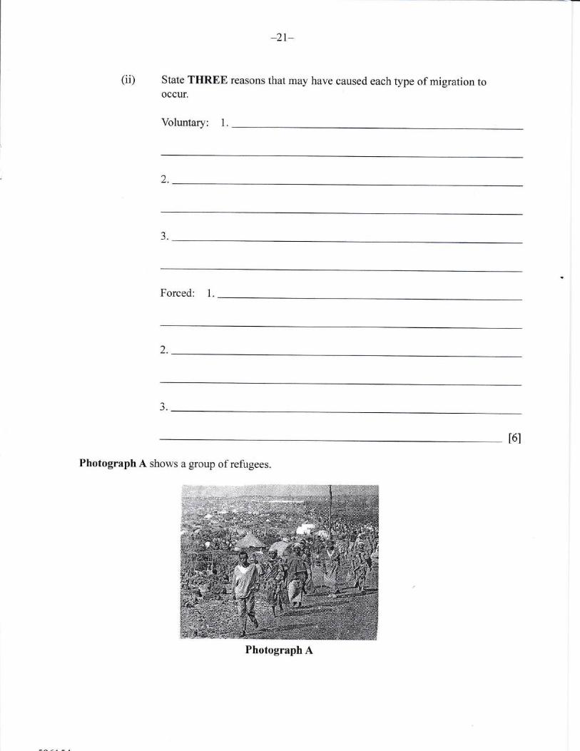
Photograph A shows a group of refugees.
Photograph A
(b)
-18-
why governments of some countries afe reluctant to acceptExplain TWO reasonsrefugees.
l.
)
(c) (i) Explain THREE problems faced by migrants in the county to which theymigrate.
1.
")
3.
t6l(ii) Name Two caribbean countries fi"om which rhe Bahamas receives most of itsmigrants.
l.
2.l2l
8.
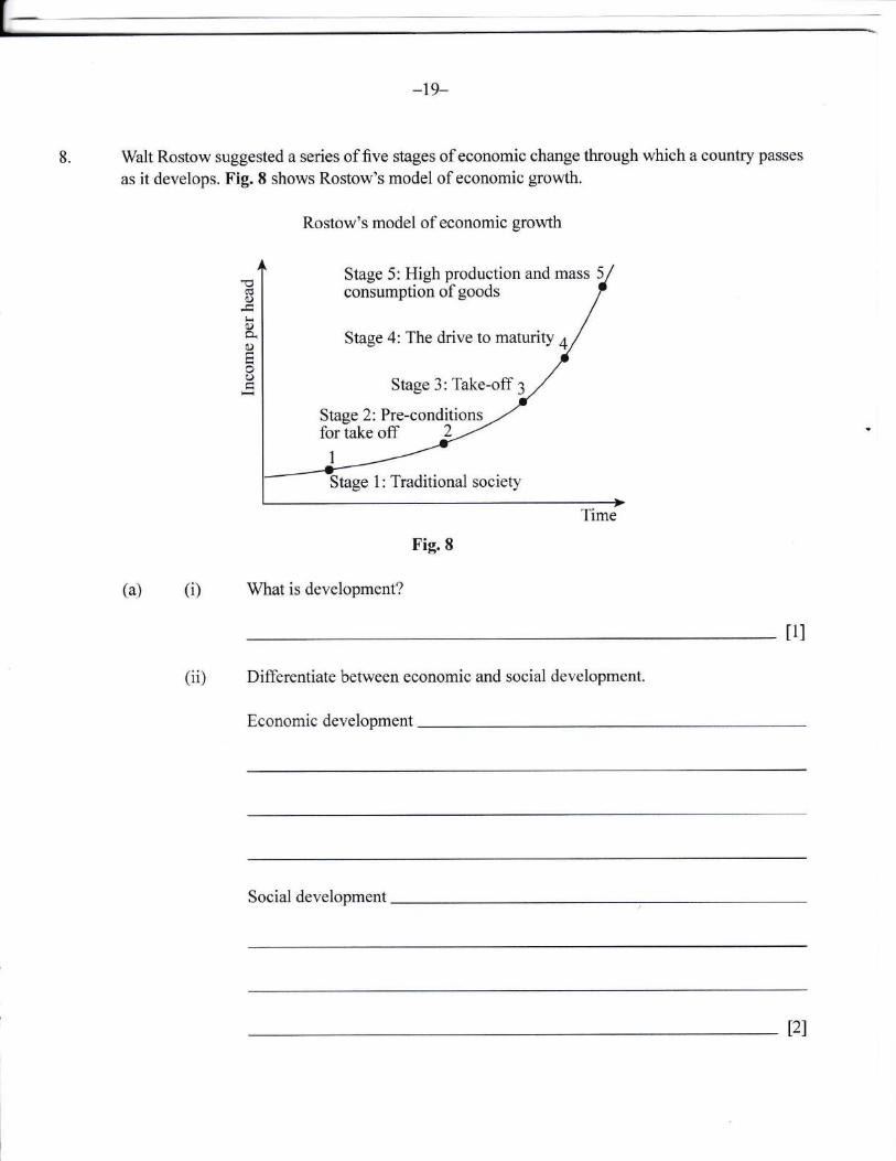
-19-
Walt Rostow suggested a series of five stages of economic change through which a country passes
as it develops. Fig. 8 shows Rostow's model of economic growth.
Rostow's model of economic growth
Fig.8
(a) (i)
(ii)
What is development?
Differentiate between economic and social development.
Economic development
cdo)
tioa(,)FoO
t1l
Stage 5: High production and mass 5consumption of goods
Stage 4: The drive to maturity 4
Stage 3: Take-off 3
Stage 2: Pre-conditionsfor take off 2 -'
Stage 1: Traditional society
Social development
t2l

-20-
(b) State THREE characteristics of a traditional society.
1.
2.
t3l
(c) Explain how a country's wealth, education and employment structure provide clear
indications of development.
1.
2.
J.
t6l
(d) Explain TWO characteristics of LEDCs which hinder development.
l.
2.
t4l
-21-
(e) Suggest TWO ways that MEDCs can assist in the development of LEDCs.
1.
2.
t4l
5109/3 BGCSESchool Number Candidate Number
Surname and Initials
T
GEOGRAPHYPAPER 3 5109/3
ruesday 31 MAY 2016 e:00A.M.-u:30A.M.
Additional materials:Ordnance Survey MapAnswer sheet
MrxrsrRYNauoNAL
OT EuUCATIoNExavuNATroNS
BAHAMAS GENERAL CERTIFICATE OF SECONDARY EDUCATION
INSTRUCTIONS TO SUPERVISORS
Candidates should be issued at the start of the examination with the paper for which they havebeen entered EITHER Paper 2 OR Paper 3.
Paper 3 is targeted at those candidates who would be expected to achieve a grade withinthe range A to D.
INSTRUCTIONS AND INFORMATION TO CANDIDATES
Do not open this booklet until you are told to do so.
Write your school number, candidate number, surname and initials in the spaces provided at thetop of this page.
This paper accounts for 50% of the total marks. There are 8 questions in this booklet.
Candidates must answer any FOUR questions from a total of eight questions. If you attemptmore than FOUR questions only the first FOUR answers will be marked. All questions carrytwenty-five marks. The mark for each part-question is given in brackets [ ].
ALL candidates are required to write their answers in the spaces provided for each question.
= This question paper consists of 26 printed pages and 2 blank pages.
-II
-IrI
1-L-
Study the map extract of Port Antonio on a scale of 1:50 000 and complete the following exercise.
l. (a) Give the four flgure grid reference of the following places.
(i) Egg Hill
(ii) Comfort Castle
(b) How is height shown on this map?
t1l
l1l ,
t2)
(c) (i) What is the drainage pattern along the Rio Grande?
(ii) Describe the pattern identified in (c)(i).
t1l
t3l
(d) (i) Identiff THREE natural features along the northern coast.
1.
t3l
2.
-l-
a-J-
(ii) Choose TWO features and explain their formation.
1.
2.
t4l
(e) (i) Name THREE services offered by PortAntonio.
l.
t3l
2.
J.
(ii) Suggest TWO recreational activities that the inhabitants of Port Antonio mayenJoy.
l
tzl2.
(f) (i) Name TWO types of settlement pattern in PortAntonio.
1.
Choose ONE type of settlementpattern and describe it. Give ONE advantage ofthis type of settlement.
t3l
t2l
(ii)
-5-
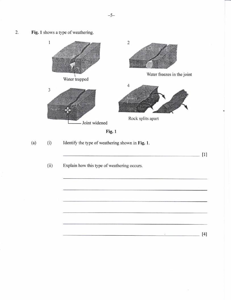
2. Fig. 1 shows a type of weathering.
(a) (i)
tll
(ii) Explain how this type of weathering occurs.
,ffiWater freezes in the joint
Rock splits apart
Fig. I
Identiff the type of weathering shown in Fig. 1.
Water trapped
t4l
(iii) Explain TWO ways in which biologioal weathering occurs.
1.
)
&)
t4l
Using the word list, complete the table below to show fast and slow forms of massmovement
FAST TYPE STOWTYPE
t4l
soil ereep Earth creep Landslip Rockfall

-7-
(c) Explain THREE effects of mass movement on the environment.
1.
2.
J.
t6l
(d) Describe THREE ways that people can help to prevent mass movement.
l.
2.
aJ.
I6l
(i)(a)1-)"
-8-
Explain THREE factors which favour plant growth in the Equatorial Region.
l"
2.
aJ.
t6l
Fig. 2 shows a cross-section through a tropical rainforest.
45
40
35
30
25
20
15
10
5
Fig.2
Name the world's TWO largest areas of tropical rainforest.
1.
2.
'IJ
C)
-o
30a,)
:E
(ii)
t2l
-9-
(iii) Describe each layer of the tropical rainforest.
t6l
(b) List TWO species of trees in the rainforest"
1.
)t1l
(c) Explain why the soil in rainforests are relatively infertile.
t4l
-10-
(d) Explain TIIREE ways in whioh plant* adaptto co.nditions irl the min&re.st,
t.
2.
3.
t5l
4" Fig. 3 shows the
I Deep waterWater moves in a circularmotion producing the waveform
Wind
-1 1-
formation of waves.
II Water is shallower closer to the coast. Friction with the seabed slows movement at the base of the
circular movement of the water. Top of wave continues to move forward. Wave height and steepness increase
III Wave breaks
Fig.3
(a) (i) What is a wave?
tll
(ii) List THREE factors that determine the size of a wave.
1.
Complete the table below to show TWO differences between Constructive and Destructive
waves"
Constructive Destructive
t4l
t3l
2.
aJ.
(b)
-il
-12-
(c) Name and explain THREE ways in which waves erode'
1.
)
aJ.
t6l
(d) It is important to manage coastal areas. Name and explain THREE ways that coastal
areas are protected in The Bahamas'
l.
)
J.
t6l
r--l J-
(e) With the aid of a diagram, explain TWO ways in which waves transport material.
l.
.)
I
Wave Transport
-14-
5. Fig. 4 gives views about forestry expressed by eonservation groups.
Every minute, an area of rainforest, the size of 15 football pitches, is destroyed.
At the present rate of destruction, in 40 years'time there will be virtually no more
rainforest. That means the Earth's climate will change. We will lose a precious
source of medicine. Wb will be deprived of an important source of food and
industrial products. And we will lose over half the world's animal and plant
species.
Fig. 4 The New Wider World 2nd Edition by David Waugh
(a) (i) What term is used for the large scale destruction of forest?
l1l i
(ii) Explain THREE causes of forest destruction.
1.
2.
a-1.
t6l
-15-
(iii) Suggest TWO ways that the removal of trees can prove beneficial to a country.
1.
2.
t4l
(b) Explain THREE reasons why forests and woodlands are important to people in the 'Caribbean.
1.
2.
3.
t6l
-16-
(c) Name TWO types of forest found in the Caribbean.
1.
t2l
(d) Complete the table below csmparing the forestry industry in Canada to that of theCaribbean (e.g, types oftrees etc.),
Canada Caribbean
I 1.
2. n
J. J.
t6I
-17-
6. (a) What is the study of population called?
t1l
(b) How are population statistics obtained in The Bahamas?
12)
(c) Explain THREE physical factors that influence the distribution of population.
1.
2.
-r.
t6l
-18-
(d) Fig. 5 shows the population structure of France and Fig. 6 shows the population structureof Brazil.
Population pyramid for France (MEDC) Population pyramid for Brazil (LEDC)
Different age groups Different age groups
+85-8980-8473-797A-7465496o-6455-5950-54454940-4435-3930-3425--292o-24l5-tt0-t45-9H
s43 210 0l 2 3 4 so/o oftotal 7o oftotal
male population female population
765 432 t
Yo of totalmale population
+85-8980-8475-797V1465496H,455-5950-5445494H,435-3930-3425-292V24I 5-19l0-t 45-9
3 4 5 67o% of total
female population
Fig.6Fig.5
In which country is there a longer life expectancy?(i)
(ii) In which country is there a greater percentage of dependants?
(iii) List THREE problems created by ageing populations.
1.
t1l
tl l
2.
aJ.
t3l
-19-
(iv) List THREE strategies for increasing population in MEDCs.
1.
2.
J.
t3l
(e) Explain FOUR strategies for reducing population growth in LEDCs.
l.
2.
3.
4.
t8l
-20-
Fig.7
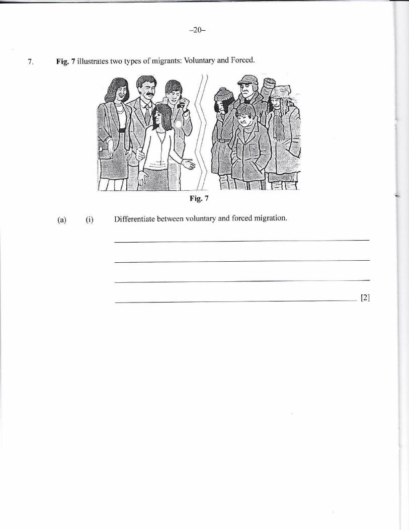
Differentiate between voluntary and forced migration.
Fig. 7 illustrates two types of migrants:7. Voluntary
lt\ ll I
h\, i
pildI lt fr
s\' lill "_li
and Forced.
(i)(a)
t?l
-21-
(ii) state THREE reasons that may have caused each type of migration tooccur.
Voluntary: 1.
2.
aJ.
Forced: 1.
2.
J.
t6l
Photograph A shows a group of refugees.
Photograph A
(b) Explain TW, O reasons wtry gorenrments of $ome coulmes arg relucta"[t to aceept
refugees.
L
2,
(c) (0 Explain THREE problems faeed by migrants iu the countrt to which they
migrate.
1
,1L.,
aJ.
t6l
(ii) Name the earibbean counff from u&ich The Bahauxrs receives most sf itsmigrants,.
+3-
(iiD Explain THREE strategies used by the government of The Bahamas to controlthe large influx of immigrants.
1.
2.
3.
t6l
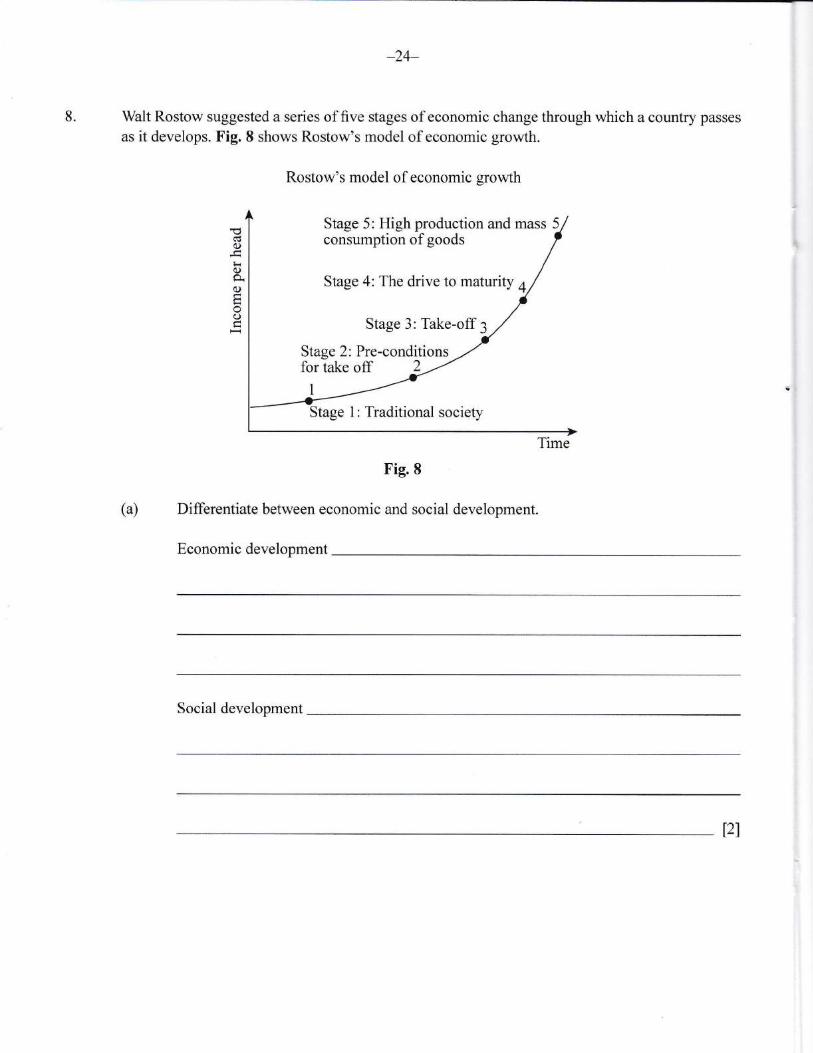
8.
)4-
Walt Rostow suggested a series of five stages of economic change through which a country passes
as it develops. Fig. 8 shows Rostow's model of economic growth.
Fig.8
(a) Differentiate between economic and social development.
Economic development
C)
tiogOH
O
Rostow's model of economic growth
Stage 5: High production and mass 5consumption of goods
Stage 4: The drive to maturity 4
Stage 3: Take-off 3
Stage 2: Pre-conditions
Stage 1: Traditional society
Time
Social development
t2)
*25-
(b) State THREE characteristics of a traditional society.
1.
2.
aJ. t3l
(c) Explain THREE ways that a country's level of development is measured.
l.
2.
3.
t6l
-26-
(d) Explain FOUR characteristics of LEDCs which hinder development.
t.
2.
J.
4.
t8l
(e) Suggest THREE solutions to the problems associated with underdevelopment in LEDCs.
1.
2.
J.
t6l