Embed Size (px)
Citation preview
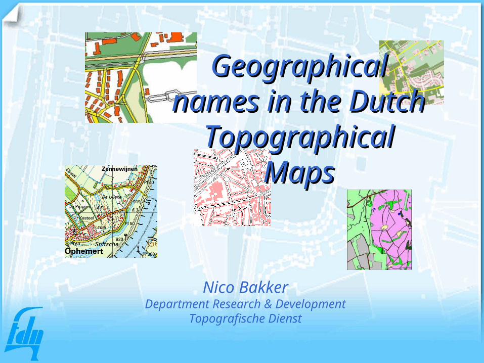
Geographical Geographical names in the names in the
Dutch Dutch Topographical Topographical
MapsMaps
Nico BakkerDepartment Research & Development
Topografische Dienst

Production overview
Aerial Photographs
TOP10vector
Terrain Reconnaissance
Photogrammetry
UpdatedAerial Photograph
orthophoto
digitising
check
TOP10vector

Pencomputer for reconnaissance
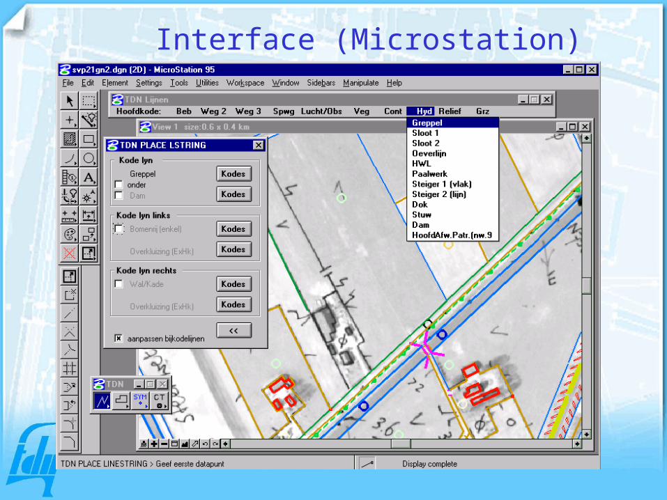
Interface (Microstation)

TOP10vector Topographic map 1:25.000

Specifications/Handbook
Namenboek Topografische Dienst
Handleiding
Versie 2001.1

Explanation2.1. Preface2.1.2 Sources / general information2.1.3 Use of deviated corps for populated places2.1.4 Spacing of names of populated places2.1.5 Description of quarters of towns and industrial areas
Selection of names2.2 Selection of names of farms or houses 2.3 Local names2.4 Foreign names2.5 Depth and depth line figures2.6 Street names2.7 Buildings2.8 Elevation numbers and contour lines 2.9 Low water mark2.10 Polder name
Content Handbook (1)
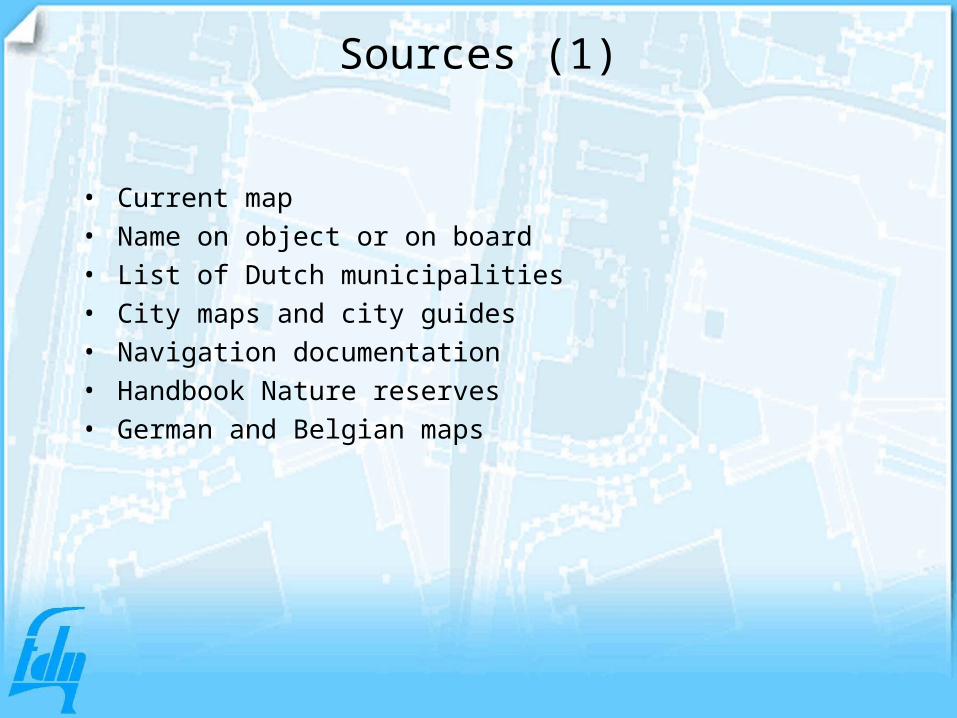
Sources (1)
• Current map• Name on object or on board• List of Dutch municipalities• City maps and city guides• Navigation documentation• Handbook Nature reserves• German and Belgian maps

Sources (2)
Object Information
Name Municipality Official name by law
Place name Municipality
Field name Municipality, local information, owners etc.
Polder name Waterboards
Canal Navigation documentation
River, stream, Waterboards, local information
Road name Municipality, local information

3.1 General rules3.2 Use of van hyphen 3.3 Use of capitals3.4 Orthography of (farm)houses3.5 Capitals in names of farms 3.6 Splitting names3.7 Relation between types the corps3.8 Frisian toponyms
Content Handbook (2)Orthography
Languages
• Dutch• Frisian

Frisian and Dutch names

How to handle the 2 languages
Object Name
Municipality name Official name (can be Ditch or Frisian)
Place name First name on board, second name translation, in smaller corps
Polder Name in the field (can be Dutch or Frisian)
Watercourse, river Name in the field (can be Dutch or Frisian), unless official source gives name in Dutch
Field name Name in the field (can be Dutch or Frisian), unless official source gives name in Dutch
Street, road Name in the field (can be Dutch or Frisian), sometimes two names
Farm, building Name on the house or building

Some translationsFrisian Dutchbosk bosbrêge brugbuorren burendyk dijkgroppe greppelhege hogekoarte korteleane laanlege lagelytse kleinemar, mear meermoune molennije nieuwepaed padryd riedskeane schuinetsjerke kerktun tuinwei wegwyk wijkwyt wit

Reconnaissance of topographical names (1)
4.1 Reconnaissance 4.2 Preparation4.2.1 Overview of sources4.2.2 Description of information4.3 Activities during field work4.4 Documenting the name information4.4.1 Documentation on the register4.4.2 Documentation on the name model
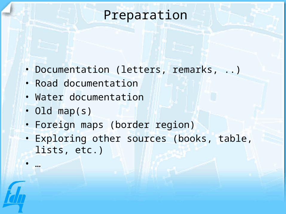
Preparation
• Documentation (letters, remarks, ..)• Road documentation• Water documentation• Old map(s)• Foreign maps (border region)• Exploring other sources (books, table, lists,
etc.)• …

4.1 Reconnaissance 4.2 Preparation4.2.1 Overview of sources4.2.2 Description of information4.3 Activities during field work4.4 Documenting the name information4.4.1 Documentation on the register4.4.2 Documentation on the name model
Reconnaissance of topographical names (2)

Reconnaissance
• Visiting official authorities (municipalities, water boards, etc.)
• Names on boards, signs, buildings, ….• Street names• Local people• ….
4.1 Reconnaissance 4.2 Preparation4.2.1 Overview of sources4.2.2 Description of information4.3 Activities during field work4.4 Documenting the name information4.4.1 Documentation on the register4.4.2 Documentation on the name model
Reconnaissance of van topographical names (3)
Documentation
• The source of the name is documented:
• Name of authority, persons, date, etc

Placing the names on the map
5.1 General rules5.1.1 Caption5.1.2 Colour of the text5.1.2 Corps of the text5.1.3 Often used text5.1.4 Spacing5.1.5 Superior placing of letters and numbers5.1.6 Abbreviations

Letter family and type
Application family type
Name Municipality Univers 45 Normal
Point Objects (1:100.000) Univers 47 Normal, small
Point objects,Univers 55 Normal, halfbold
Line objecten, as roads, waterways.Cursief, halfbold
Area's f.e.. Field-names, polder-names, lakes, ..
Point objects, (1:100.000) Univers 57 Normal
Univers 58 Italic
Populated places Univers 65 Normal, Bold,
Populated places (1:250.000) Univers 67 Normal, Bold,
Univers 56

Placing the names on the map
5.1 General rules5.1.1 Caption5.1.2 Colour of the text5.1.2 Corps of the text5.1.3 Often used text5.1.4 Spacing5.1.5 Superior placing of letters and numbers5.1.6 Abbreviations

Tabel topographic objects
Tabel topographic objectscolumn 1 column 2 column 3
Univers corps Univers corps Univers corps
exampleBuilding B E/S 55 85 55 80 57 80
Populated place > 25,000 B E 65 170 65 160 65 120
column 11
Univers corps Univers corps Univers corps Univers corps
example (cont)~ ~ ~ ~ ~ ~ ~ ~67 90 67 90
column 4 column 5 column 6Object or geographical unit B/P/R/V E/S
1:25.000 1:50.000 1:100.000
column 7 column 8 column 9 column 10Remarks1:250.000 1:500.000 Stadspl.gr. Vliegveldkrt

AbbreviationsUsed abbreviations in mapseries 1:250.000
A Antenne AntenneBr Brug BridgeB Gebouw BuildingC Schoorsteen Chimney-stackCh Kerk ChurchCt Koeltoren Cooling towerCp Kraakinstallatie Cracking plantCr Kraan CraneD Boortoren DerrickF Vlampijp Flare-chimneyG Gashouder GasometerH Hoogspanningsmast High tension pylonLB Hefbrug Lifting bridgeLT Heftoren Lifting towerL Vuurtoren LighthouseM Mast MastR Radiotelescoop RadiotelescopeS Silo SiloSH Mijnsteenberg Spoil heapST Torenspits SteepleT Tank TankTM Straaltoren Transmitting mastTR Toren TowerTT Straaltoren Transmitting towerTVT TV-toren TV towerW Watertoren Water towerWR Windmolenpark Wind-power plant

Placing the names on the map
5.1 General rules5.1.1 Caption5.1.2 Colour of the text5.1.2 Corps of the text5.1.3 Often used text5.1.4 Spacing5.1.5 Superior placing of letters and numbers5.1.6 Abbreviations

Use of colours at different maps
1:25,000
1:50,000
1:100,000
1:250,000
1:500,000
Black yes yes yes yes yes
Red yes yes yes
Blue yes yes yes yes yes
Brown yes yes yes
Violet yes

Text types
• CAPITAL• Normal• Bold• Half bold• Italic• Narrow• S p a c e d
Geogr names at different map scales
• Overview with gazetteer codes

Gazet TDN kode Omschrijving gazet_code_EN 25d 50d 100d 250d 500d Omschrijving van de TDN-kode
EN Object_codeObject_description_EN
BLDG 1009 Building, group of buildings Gebouw (-encomplex)
BLDG 1029 Building, group of buildings Gebouw encomplex (groot)
BLDG 1179 Building, group of buildings Kazerne/legerplaats/Milit.gebouw
MISC 1209 Miscellaneous landmarks Belangrijk gebouw /Bijzonder object
BLDG 1219 Building, group of buildings Ziekenhuis
BLDG 1229 Building, group of buildings Universiteit
BLDG 1239 Building, group of buildings Kasteel
POWS 1349 Power station Electriciteitscentrale
MILL 1599 Mill Molen
BLDG 1719 Building, group of buildings sbm Religieus gebouw
BLDG 1729 Building, group of buildings Klooster/Abdij
MONU 1789 Monument, memorial Monument/gedenkteken
LH 1859 Lighthouse Vuurtoren
FORT 1899 Fort, entrenchment [Voormalig] fort
RECR 1919 Recreational facilities IJsstadion
RECR 1929 Recreational facilities Renbaan
RECR 1939 Recreational facilities Circuit
RECR 1979 Recreational facilities Dierenpark/Safaripark

Production flow
• Preparation• Sources research• Field work• Name documentation• Digitising in Microstation• Check-plot• Correction• Publishing maps

Dgn-file txt (1)

Map (1)

Dgn-file txt (2)

Map (2)

Gazetteers
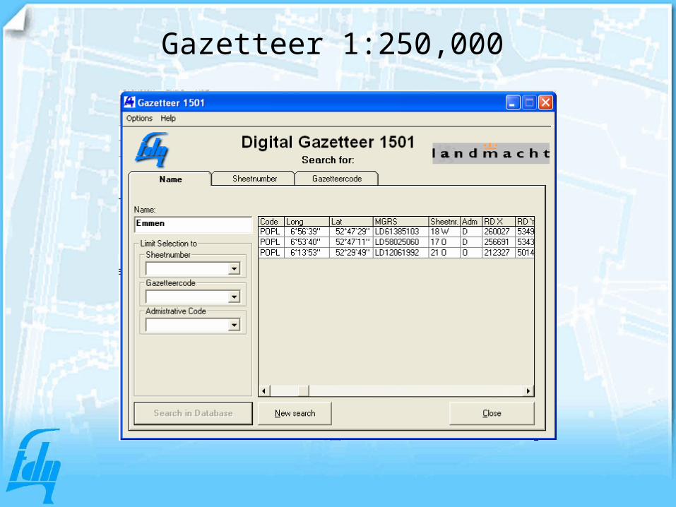
Gazetteer 1:250,000

Gazetteercodes (1)gazcode code gazcode Object_description_NL Object_description_EN
Dutch English
GEB 1009 BLDG Gebouw, gebouwencomplex Building, group of buildings
DIV 1209 MISC Diverse puntobjecten Miscellaneous landmarks
CNTR 1349 POWS Energiecentrale Power station
MLN 1599 MILL Molen Mill
MONU 1789 MONU Monument, gedenkteken Monument, memorial
VT 1859 LH Vuurtoren, lichttoren Lighthouse
FORT 1899 FORT Fort, schans Fort, entrenchment
TUNN 3449 TUNN Tunnel Tunnel
WEG 3509 ROAD Weg, straat, laan, pad Road, street, lane, path
VP 3709 RIVerkeersplein, verkeersknooppun Road intersection, road junction
BRUG 3729 BRDG Brug, viaduct Bridge, viaduct
PARK 3839 PARK Parkeerplaats Parking area
VLV 4509 AF Vliegveld, luchthaven Airfield, airport
BOS 5019 FRST Bos Forest
HEI 5249 HTH (voormalig) Heidegebied (former) Heathland
BEGR 5309 CEM Begraafplaats Cemetery
KAN 6039 CNAL Kanaal, vaart, sloot Canal, waterway, ditch
ZEE 6109 SEA Zee Sea
MEER 6119 LAKE Meer, plas, vijver Lake, pool, pond
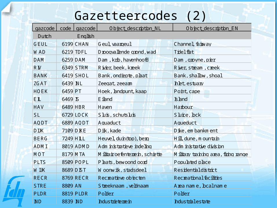
Gazetteercodes (2)gazcode code gazcode Object_description_NL Object_description_EN
Dutch English
GEUL 6199 CHAN Geul, vaargeul Channel, fairway
WAD 6219 TDFL Droogvallende grond, wad Tidel flat
DAM 6259 DAM Dam, krib, havenhoofd Dam, groyne, pier
RIV 6349 STRM Rivier, beek, kreek River, stream, creek
BANK 6419 SHOL Bank, ondiepte, plaat Bank, shallow, shoal
ZGAT 6439 INL Zeegat, zeearm Inlet, estuary
HOEK 6459 PT Hoek, landpunt, kaap Point, cape
EIL 6469 IS Eiland Island
HAV 6489 HBR Haven Harbour
SL 6729 LOCK Sluis, schutsluis Sluice, lock
AQDT 6889 AQDT Aquaduct Aqueduct
DIJK 7109 DIKE Dijk, kade Dike, embankment
BERG 7249 HILL Heuvel, duin(top), berg Hill, dune, mountain
ADMI 8019 ADMD Administratieve indeling Administrative division
MOT 8179 MTA Militair oefenterrein, schiette Military training area, firing range
PLTS 8509 POPL Plaats, bewoond oord Populated place
WIJK 8689 DIST Woonwijk, stadsdeel Residential district
RECR 8769 RECR Recreatieve objecten Recreational facilities
STRE 8809 AN Streeknaam, veldnaam Area name, local name
PLDR 8819 PLDR Polder Polder
IND 8839 IND Industrieterrein Industrial estate
Development TOP10NL and smaller scales

OGT 29 mei 2002
Topographic basic objects
Terrain
Building
Road segment
Water segment
Railroad segment
Specific terrain element
Administrative area Conservation area
Geographic areaFunctional area

Topographic basic objects
Entity
Road segment
Railroad segmentl
Water segment
Building
Terrain
Ispecial terrain element/construction
Administrative area
Conservation area
Geographic area
Functional area
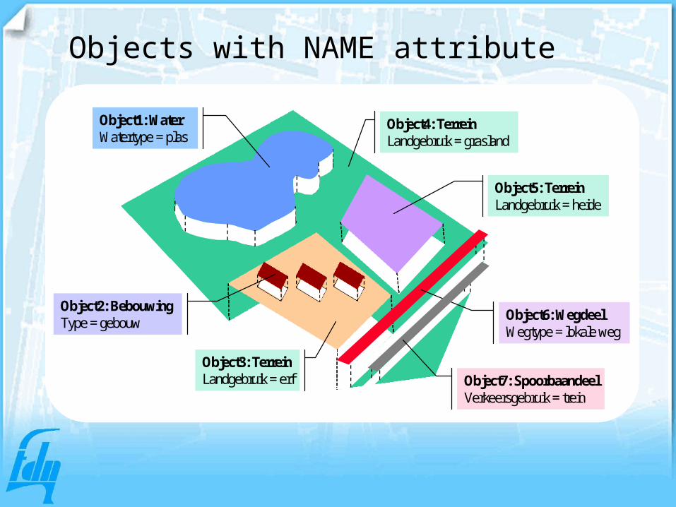
Object5: TerreinLandgebruik = heide
Object3: TerreinLandgebruik = erf
Object1: WaterWatertype = plas
Object2: BebouwingType = gebouw
Object4: TerreinLandgebruik = grasland
Object6: WegdeelWegtype = lokale weg
Object7: SpoorbaandeelVerkeersgebruik = trein
Object5: TerreinLandgebruik = heide
Object3: TerreinLandgebruik = erf
Object1: WaterWatertype = plas
Object2: BebouwingType = gebouw
Object4: TerreinLandgebruik = grasland
Object6: WegdeelWegtype = lokale weg
Object7: SpoorbaandeelVerkeersgebruik = trein
Objects with NAME attribute

Object9: InrichtingselementType = boom
Object8: BeheersgebiedType = nationaal parkNaam = Hoge Veluwe
Object9: InrichtingselementType = boom
Object8: BeheersgebiedType = nationaal parkNaam = Hoge Veluwe
Special polygon for geographical names

Object characteristics: wegdeel
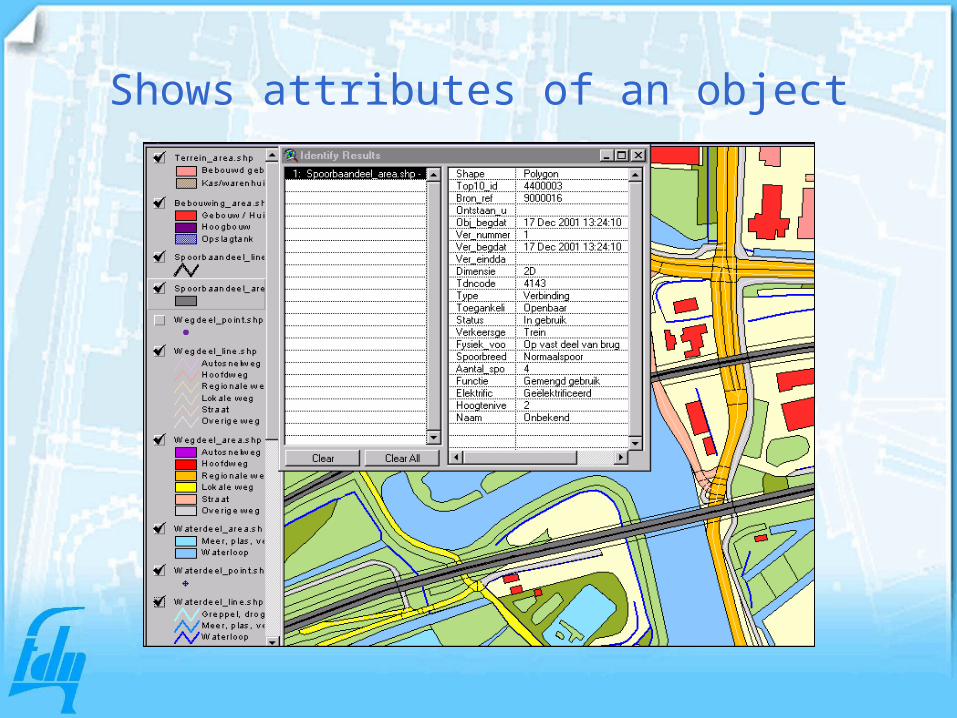
Shows attributes of an object

Meta-information for each object